Embed Size (px)
Citation preview
I I I I I I I I I I I I I I I I I I I
~ TERRAQUEST LTD.
2.329'5 4
Operations &Interpretation Report DiaMine Explorations Inc.
High Resolution Horizontal Magnetic Gradient & XDS-VLF-EM Airborne Survey
Attawapiskat Project Attawapiskat, Ontario
AUG " U Z006 /),... ~
GEOSCIENCE ASSESSMENT OFFICE
Terraquest Ltd., Airborne Geophysical Surveys. - Contract 8-201
August 28, 2006
Report #: B-201
Requested by: Mr. John Skinner
OiaMines Exploration Inc.
Prepared by: Charles Barrie, Managing Partner
Terraquest Ltd.
2006-{)8-25
I I I I I I I I I I I I I I I I I I I
Operations Report for DiaMine Explorations Inc.: High Resolution Magnetic Gradient & XDS-VLF-EM Survey, Attawapiskat Project, Attawapis!cat, Ontario
Table of Contents
1. INTRODUCTION .......................................................................................................................................... 1
2. SURVEY SPECIFICATIONS ....................................................................................................................... 2
2.1. 2.2. 2.3. 2.4. 2.5. 2.6.
1. 2. 3. 4.
2.7.
LOCATION ............................................................................................................................................... 2 LINE SPECIFICATIONS .......................................................................................................................... 3 SURVEY KILOMETRAGE ...................................................................................................................... 3 NAVIGATION SPECIFICATIONS ......................................................................................................... 3 FLIGHT PLAN .......................................................................................................................................... 4 TOLERANCES ......................................................................................................................................... 5 Traverse Line Interval ............................................................................................................................... 5 Terrain Clearance: .................................................................................................................................... 5 Diurnal Variation: ..................................................................................................................................... 5 GPSData: .................................................................................................................................................. 5 NAVIGATION AND RECOVERY .......................................................................................................... 5
3. AIRBORNE GEOPHYSICAL EQUIPMENT ............................................................................................. 6
3.1. 3.2. 3.3.
1. 2. 3. 4. 5. 6. 7. 8. 9. 10. 11. 12.
SURVEY AIRCRAFT ............................................................................................................................... 6 EQUIPMENT OVERVIEW ...................................................................................................................... 7 GEOPHYSICAL EQUIPMENT SPECIFICA nONS ............................................................................... 8 Magnetics: ................................................................................................................................................. 8 Magnetometer Counter .............................................................................................................................. 8 XDS-VLF-EM System ................................................................................................................................ 9 Tri-Axial Fluxgate Magnetic Sensor ..... ..................................................................................................... 9 Analog Processor ......... ............................................................................................................................ 10 Data Acquisition System .......................................................................................................................... 10 Real-Time Correction CPS Receiver ....................................................................................................... II Navigation System ................................................................................................................................... II Radar Altimeter ....................................................................................................................................... 12 Barometric Altimeter ............................................................................................................................... 12 Video Camera .......................................................................................................................................... 12 Video CD Recorder ................................. ................................................................................................. 12
4. BASE STATION EQUIPMENT .................................................................................................................. 13
4.1. 4.2.
5. 5.1. 5.2.
BASE STATION MAGNETOMETER ................................................................................................... 13 BASE STATION GPS RECIEVER ........................................................................................................ 13
TESTS AND CALmRA TIONS ................................................................................................................... 14
MAGNETIC FIGURE OF MERIT ......................................................................................................... 14 MAGNETIC LAG TEST ......................................................................................................................... 14
Terraquest Ltd., Airborne Geophysical Surveys Contract 8-201
2006-08-28 ii
I I I I I I I I I I I I I I I I I I I
Operations Report for DiaMine Explorations Inc.: High Resolution Magnetic Gradient & XDS- VLF-EM Survey, Attawapiskat Project, Attawapiskat, Ontario
6. 6.1. 6.2. 6.3. 6.4. 6.5.
7. 7.1. 7.2.
8. 8.1. 8.2. 8.3. 8.4. 8.5. 8.6. 8.7.
9.
10. 10.1. 10.2.
LOGISTICS .................................................................................................................................................. 15
PERSONNEL .......................................................................................................................................... 15 FIELD OPERATIONS ............................................................................................................................ 15 BASE OF OPERATIONS ....................................................................................................................... 15 ACCOMMODATION ............................................................................................................................. 15 FUEL ....................................................................................................................................................... 15
DATA PROCESSING .................................................................................................................................. 16
DATA QUALITY CONTROL ................................................................................................................ 16 FINAL DATA PROCESSING ................................................................................................................ 16
AEROMAGNETIC INTERPRETATION ................................................................................................. 18
INTRODUCTION ................................................................................................................................... 18 GEOLOGy .............................................................................................................................................. 18 SHALLOW MAGNETIC COMPONENT .............................................................................................. 18 KIMBERLITE EXPECTATIONS ........................................................................................................... 18 DISCUSSION .......................................................................................................................................... 19 RECOMMENDATIONS ......................................................................................................................... 20 CERTIFICATION OF QUALIFICATION ............................................................................................. 21
SUMMARY .................................................................................................................................................... 22
APPENDICES ........................................................................................................................................ 23
CERTIFICATE OF QUALIFICATION .................................................................................................. 23 DAILY LOG ............................................................................................................................................ 24
Terraquest Ltd., Airbome Geophysical Surveys Contract 8-201
2006-08-28 iii
I I I I I I I I I I I I I I I I I I I
Operations Reportfor DiaMine Explorations Inc.: High Resolution Gradient Aeromagnetic &xDS-VLF-EM Survey, Attawapiskat Project, Attawapiskat ON
1. INTRODUCTION
This report describes the specifications and parameters of an airborne geophysical survey carried out for:
DIAMINE EXPLORATIONS INC. 23-5225 Orbiter Drive Mississauga, ON L4W 4Y8
Attention: Mr. John Skinner
The survey was perfonned by:
TERRAQUEST LTD., 2-2800 John Street, Markham, ON, Canada L3ROE2 Ph: 905-477-2800 ext. 22 [email protected].
The purpose of the survey of this type is to collect geophysical data that can be used to prospect directly for anomalous magnetic and conductive areas in the earth's crust which may be caused by or related to economic minerals. Secondly, the geophysical patterns can be used indirectly for exploration by mapping the geology in detail, including faults shear zones, folding, alteration zones and other structures.
To obtain this data, the area was systematically traversed by aircraft carrying geophysical equipment along parallel flight lines spaced at even intervals and oriented so as to intersect the geology and structure in a way as to provide optimum contour patterns of the geophysical data.
Terraquest Ltd., Airborne Geophysical SUrveys Contract: 8-201
2006-08-28
1
I I I I I I I I I I I I I I I I I I I
Operations Report for DiaMine Explorations Inc.: High Resolution Gradient Aeromagnetic &xDS-VLF-EM Survey, Attawapiskat Project, Attawapiskat ON
2. SURVEY SPECIFICATIONS
2.1. LOCATION
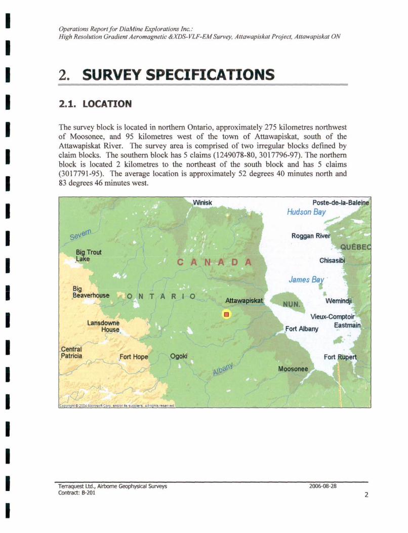
The survey block is located in northern Ontario, approximately 275 kilometres northwest of Moosonee, and 95 kilometres west of the town of Attawapiskat, south of the Attawapiskat River. The survey area is comprised of two irregular blocks defined by claim blocks. The southern block has 5 claims (1249078-80, 3017796-97). The northern block is located 2 kilometres to the northeast of the south block and has 5 claims (3017791-95). The average location is approximately 52 degrees 40 minutes north and 83 degrees 46 minutes west.
Big Trout .Lake CAN A 0 A
Big Beaverhouse . ONTARIO
l ansdowne Ho sec )
~~ Central .Patricia
Terraquest Ltd., Airborne Geophysical Surveys Contract: B-201
o
P goki
Chisasib·
2006-08-28
2
I I I I I I I I I I I I I I I I I I I
Operations Report for DiaMine Explorations Inc.: High Resolution Gradient Aeromagnetic &XDS-VLF-EM Survey, Attawapiskat Project, Attawapiskat ON
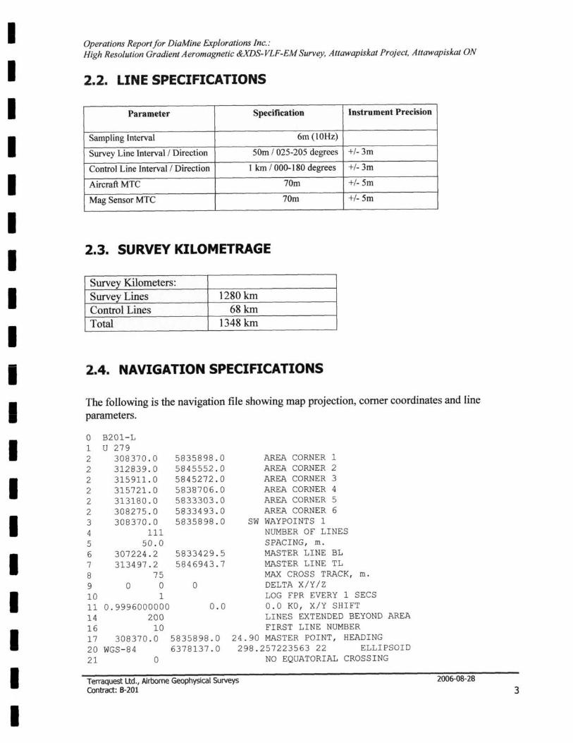
2.2. LINE SPECIFICATIONS
Parameter Specification Instrument Precision
Sampling Interval 6m (lOHz)
Survey Line Interval / Direction 50m / 025-205 degrees +/- 3m
Control Line Interval / Direction 1 km / 000-180 degrees +/- 3m
Aircraft MTC 70m +/- 5m
Mag Sensor MTC 70m +/- 5m
2.3. SURVEY KILOMETRAGE
Survey Kilometers: Survey Lines 1280 km Control Lines 68km Total 1348 km
2.4. NAVIGATION SPECIFICATIONS
The following is the navigation file showing map projection, comer coordinates and line parameters.
o 1 2 2 2 2 2 2 3 4 5 6 7 8 9
B201 - L U 279
308370.0 312839 . 0 315911 . 0 315721.0 3l3180.0 308275 . 0 308370.0
111 50 . 0
307224.2 3l3497 . 2
75 o 0
10 1
5835898.0 5845552 . 0 5845272 . 0 5838706.0 5833303 . 0 5833493 . 0 5835898 . 0
5833429 . 5 5846943 . 7
o
11 0.9996000000 0.0 14 200 16 10 17 308370.0 5835898.0 20 WGS-84 6378137.0 21 0
AREA CORNER 1 AREA CORNER 2 AREA CORNER 3 AREA CORNER 4 AREA CORNER 5 AREA CORNER 6
SW WAYPOINTS 1 NUMBER OF LINES SPACING, ffi.
MASTER LINE BL MASTER LINE TL MAX CROSS TRACK, ffi.
DELTA X/Y/Z LOG FPR EVERY 1 SECS 0 . 0 KO, X/Y SHIFT LINES EXTENDED BEYOND AREA FIRST LINE NUMBER
24.90 MASTER POINT, HEADING 298 . 257223563 22 ELLIPSOID
NO EQUATORIAL CROSSING
Terraquest Ltd., Airborne Geophysical Surveys Contract: B-201
2006-08-28
3
I I I I I I I I I I I I I I I I I I I
Operations Reportfor DiaMine Explorations Inc.: High Resolution Gradient Aeromagnetic &XDS-VLF-EM Survey, Attawapiskat Project, Attawapiskat ON
30 20 9600 N 1 31 20 9600 N 1 38 0 39 5 41 0.00 80 0.00 83 0 85 100 102 UTM
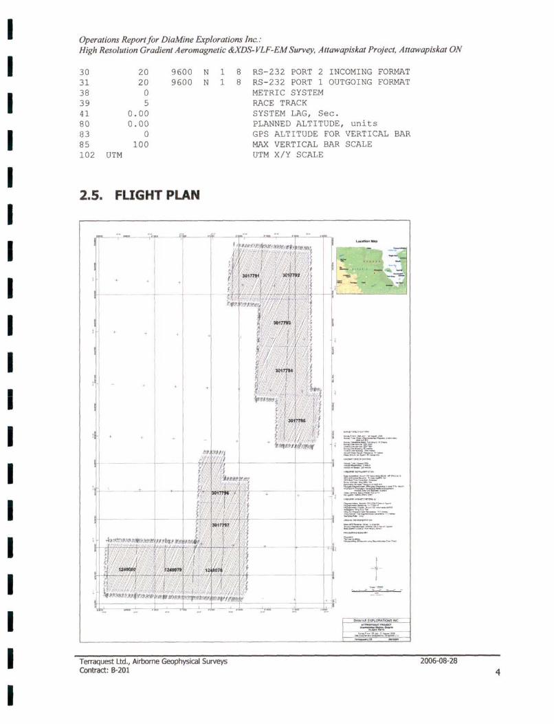
2.5. FLIGHT PLAN
+
+ + +
+ +
+
Terraquest Ltd., Airborne Geophysical Surveys Contract: 8-201
8 8
RS-232 PORT 2 INCOMING FORMAT RS-232 PORT 1 OUTGOING FORMAT METRIC SYSTEM RACE TRACK SYSTEM LAG, Sec. PLANNED ALTITUDE, units GPS ALTITUDE FOR VERTICAL MAX VERTICAL BAR UTM X/Y SCALE
SCALE
=~t!! ..-.. _"'-
~~.,
==_~::.:t:..'7:. s:~-==-...:!!...-;-,-
-f-
BAR
m ... :--:::' .... _
2006-{)8-28
4

I I I I I I I I I I I I I I I I I I I
Operations Reportfor DiaMine Explorations Inc.: High Resolution Gradient Aeromagnetic &XDS-VLF-EM Survey, Attawapiskat Project, Attawapiskat ON
2.6. TOLERANCES
1. Traverse Une Interval Reflights would take place if the final corrected flight path was greater than 30 m. from the intended flight path over a distance greater than 1 kilometre.
2. Terrain Clearance:
The aircraft mean terrain clearance was smoothly maintained at 60 metres MTC in a drape mode. Reflights would take place if the final corrected altitude deviated from the flight altitude by +/-15 metres over a distance of one kilometre or more if, in the pilot's opinion, it is safe to do so.
3. Diurnal Variation:
Diurnal activity was limited to 5 nT deviation from 60 sec. chord.
4. GPS Data:
GPS data shall include at least four satellites for accurate navigation and flight path recovery. There shall be no significant gaps in any of the digital data including GPS and magnetic data.
2.7. NAVIGATION AND RECOVERY
The satellite navigation system was used to ferry to the survey sites and to survey along each line. The survey coordinates were measured from the claim map and were used to establish the survey boundaries and the flight lines.
The flight path guidance accuracy is variable depending upon the number and condition (health) of the satellites employed. The selective availability normally imposed by the military was at a minimum during this period and consequently the accuracy was for the most part better than 10 metres. Real-time correction using the Trimble receiver and Omnistar broadcast services improves the accuracy to about 3 metres or less in the horizontal plane and 4-5 metres in the vertical direction.
A video camera recorded the ground image along the flight path with CD-ROM media. A video display screen in the cockpit enabled the operator to monitor the flight path during the survey.
The video flight path is in a new format as it is recorded directly onto CD's. In order to record the immense volume of video data in a given time period, the image was compressed in real time as it was recorded using software by the name of DVIX. Windows Media Player cannot play these images without the appropriate driver; this can be done easily by downloading DVIX Player at no cost from www.DVIX .com and once installed one can use either DVIX or, better yet Windows Media Player (which has controls for focusing the image).
Terraquest Ud., Airborne Geophysical Surveys Contract: 8-201
2006-08-28
5
I I I I I I I I I I I I I I I I I I I
Operations Report for DiaMine Explorations Inc.: High Resolution Gradient Aeromagnetic &XDS-VLF-EM Survey, Altawapiskat Project, Allawapiskat ON
3. AIRBORNE GEOPHYSICAL EQUIPMENT
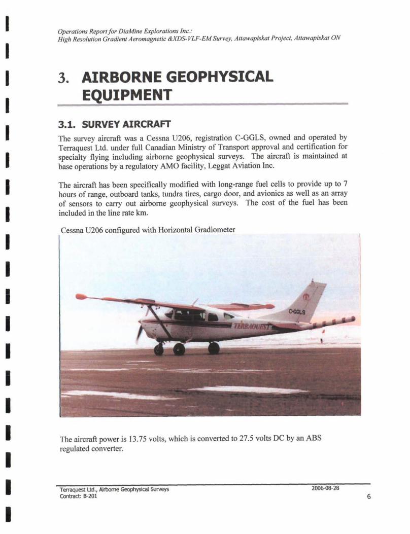
3.1. SURVEY AIRCRAFT The survey aircraft was a Cessna U206, registration C-GGLS, owned and operated by Terraquest Ltd. under full Canadian Ministry of Transport approval and certification for specialty flying including airborne geophysical surveys. The aircraft is maintained at base operations by a regulatory AMO facility, Leggat Aviation Inc.
The aircraft has been specifically modified with long-range fuel cells to provide up to 7 hours of range, outboard tanks, tundra tires, cargo door, and avionics as well as an array of sensors to carry out airborne geophysical surveys. The cost of the fuel has been included in the line rate km.
Cessna U206 configured with Horizontal Gradiometer
The aircraft power is 13.75 volts, which is converted to 27.5 volts DC by an ABS regulated converter.
Terraquest Ltd., Airborne Geophysical Surveys Contract: 6-201
2006-08-28
6
I I I I I I I I I I I I I I I I I I I
Operations Report for DiaMine Explorations Inc.: High Resolution Gradient Aeromagnetic &XDS-VLF-EM Survey, Attawapiskat Project, Attawapiskat ON
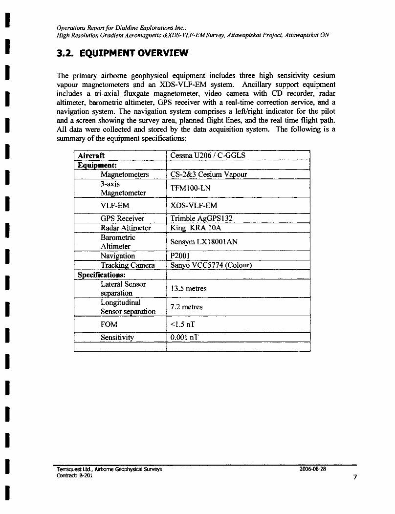
3.2. EQUIPMENT OVERVIEW
The primary airborne geophysical equipment includes three high sensitivity cesium vapour magnetometers and an XDS-VLF -EM system. Ancillary support equipment includes a tri-axial fluxgate magnetometer, video camera with CD recorder, radar altimeter, barometric altimeter, GPS receiver with a real-time correction service, and a navigation system. The navigation system comprises a left/right indicator for the pilot and a screen showing the survey area, planned flight lines, and the real time flight path. All data were collected and stored by the data acquisition system. The following is a summary of the equipment specifications:
Aircraft Equipment:
Magnetometers 3-axis Magnetometer
VLF-EM
GPS Receiver Radar Altimeter Barometric Altimeter Navigation Tracking Camera
Specifications: Lateral Sensor separation Longitudinal Sensor separation
FOM
Sensitivity
Terraquest Ltd., Airborne Geophysical Surveys Contract: 8-201
Cessna U206 / C-GGLS
CS-2&3 Cesium Vapour
TFMI00-LN
XDS-VLF-EM
Trimble AgGPSl32 King KRA lOA
Sensym LX1800 1 AN
P2001 Sanyo VCC5774 (Colour)
13.5 metres
7.2 metres
<1.5 nT
0.001 nT
2006-oB-28
7
I I I I I I I I I I I I I I I I I I I
Operations Reportfor DiaMine Explorations Inc.: High Resolution Gradient Aeromagnetic &xDS-VLF-EM Survey, Attawapiskat Project, Attawapiskat ON
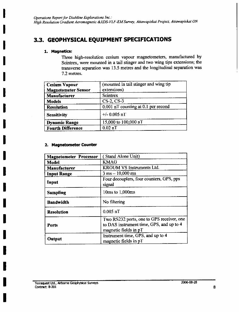
3.3. GEOPHYSICAL EQUIPMENT SPECIFICATIONS
1. Magnetics: Three high-resolution cesium vapour magnetometers, manufactured by Scintrex, were mounted in a tail stinger and two wing tips extensions; the transverse separation was 13.5 metres and the longitudinal separation was 7.2 metres.
Cesium Vapour Mapetometer Sensor Manufacturer Models Resolution
Sensitivity
Dynamic Range Fourth Difference
2. Magnetometer Counter
Magnetometer Processor Model Manufacturer Input Ran2e
Input
Sampling
Bandwidth
Resolution
Ports
Output
Terraquest Ltd., Airborne Geophysical Surveys Contract: 6-201
(mounted in tail stinger and wing tip extensions) Scintrex CS-2, CS-3 0.001 nT counting at 0.1 per second
+/- 0.005 nT
15,000 to 100,000 nT 0.02 nT
( Stand Alone Unit) KMAG KROUM VS Instruments Ltd. 3 ms -10,000 ms Four decouplers, four counters, GPS, pps signal
10ms to 1,000ms
No filtering
0.005 nT
Two RS232 ports, one to GPS receiver, one to DAS instrument time, GPS, and up to 4 ma~etic fields in ~T Instrument time, GPS, and up to 4 magnetic fields in pT
2006-08-28
8
I I I I I I I I I I I I I I I I I I I
Operations Report for DiaMine Explorations Inc.: High Resolution Gradient Aeromagnetic &xDS-VLF-EM Survey, Attawapiskat Project, Attawapiskat ON
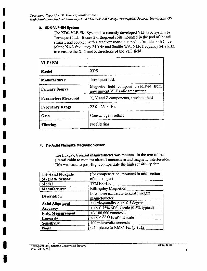
3. XDS-VLF-EM System
The XDS-VLF-EM System is a recently developed VLF type system by Terraquest Ltd. It uses 3 orthogonal coils mounted in the pod of the tail stinger, and coupled with a receiver-console, tuned to include both Cutler Maine NAA frequency 24 kHz and Seattle W A, NLK frequency 24.8 kHz, to measure the X, Y and Z directions of the VLF field.
VLF/EM
Model XDS
Manufacturer T erraquest Ltd.
Primary Source Magnetic field component radiated from government VLF radio transmitter
Parameters Measured X, Y and Z components, absolute field
Frequency Range 22.0 - 26.0 kHz
Gain Constant gain setting
Filtering No filtering
4. Tri-Axial Fluxgate Magnetic Sensor
The fluxgate tri-axial magnetometer was mounted in the rear of the aircraft cabin to monitor aircraft manoeuvre and magnetic interference. This was used to post-flight compensate the high sensitivity data.
Tri-Axial Fluxgate Magnetic Sensor Model Manufacturer
Description
Axial Alignment Accuracy Field Measurement Linearity Sensitivity Noise
Terraquest Ud., Airborne Geophysical Surveys Contract: 8-201
(for compensation, mounted in mid-section of tail stinger) TFMIOO-LN Billingsley Magn_etics Low noise miniature triaxial fluxgate magnetometer > Orthogonality> +1- 0.5 degree < +1- 0.75% of full scale (0.5% typical) +1- 100,000 nanotesla < +1- 0.0035% of full scale 100 microvoltlnanotesla < 14 Qicotesla RMS/-Hz @ 1 Hz
2006-08-28
9
I I I I I I I I I I I I I I I I I I I
Operations Report/or DiaMine explorations Inc.: High Resolution Gradient Aeromagnetic &xDS-VLF-EM Survey, Attawapiskat Project, Attawapiskat ON
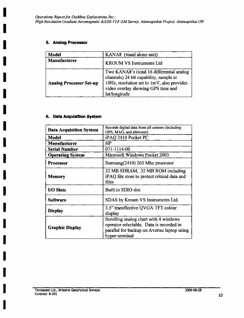
5. Analog Processor
Model Manufacturer
Analog Processor Set-up
6. Data Acquisition System
Data Acquisition System
Model Manufacturer Serial Number Operating System
Processor
Memory
110 Slots
Software
Display
Graphic Display
Terraquest Ltd., Airborne Geophysical Surveys Contract: B-201
KANA8 (stand alone unit)
KROUM VS Instruments Ltd
Two KANA8's (total 16 differential analog channels) 24 bit capability, sample at 10Hz, resolution set to 1m V, also provides video overlay showing GPS time and latllongitude
Records digital data from all sensors (including GPS, MAG, and altimeter) iP AQ 2410 Pocket PC HP 071-1114-00 Microsoft Windows Pocket 2003
Samsung(2410) 203 Mhz processor
32 MB SDRAM, 32 MB ROM including iP AQ file store to protect critical data and files
Built in SDIO slot
SDAS by Kroum VS Instruments Ltd.
3.5" transflective QVGA TFT colour display Scrolling analog chart with 4 windows operator selectable. Data is recorded in parallel for backup on A vertec laptop using h~er-terminal
2006-08-28
10
I I I I I I I I I I I I I I I I I I I
Operations Reportfor DiaMine Explorations Inc.: High Resolution Gradient Aeromagnetic &XDS-VLF-EM Survey, Attawapiskat Project, Attawapiskat ON
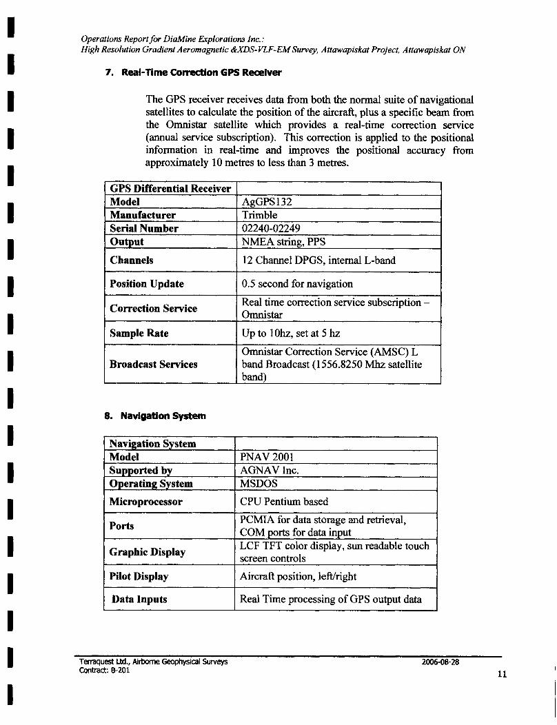
7. Real-TIme Correction GPS Receiver
The GPS receiver receives data from both the normal suite of navigational satellites to calculate the position of the aircraft, plus a specific beam from the Omnistar satellite which provides a real-time correction service (annual service SUbscription). This correction is applied to the positional information in real-time and improves the positional accuracy from approximately 10 metres to less than 3 metres.
GPS Differential Receiver Model Manufacturer Serial Number Output
Channels
Position Update
Correction Service
Sample Rate
Broadcast Services
8. Navigation System
Navigation System Model Supported by Operating System
Microprocessor
Ports
Graphic Display
Pilot Display
Data Inputs
Terraquest Ltd., Airborne Geophysical Surveys Contract: 8-201
AgGPS132 Trimble 02240-02249 NMEA string, PPS
12 Channel DPGS, internal L-band
0.5 second for navigation
Real time correction service subscription -Omnistar
Up to 10hz, set at 5 hz
Omnistar Correction Service (AMSC) L band Broadcast (1556.8250 Mhz satellite band)
PNAV2001 AGNAVInc. MSDOS
CPU Pentium based
PCMIA for data storage and retrieval, COM {!orts for data input LCF TFT color display, sun readable touch screen controls
Aircraft position, left/right
Real Time processing of GPS output data
2006-08-28
11
I I I I I I I I I I I I I I I I I I I
Operations Report for DiaMine Explorations Inc.: High Resolution Gradient Aeromagnetic &xDS-VLF-EM Survey, Attawapiskat Project, Attawapiskat ON
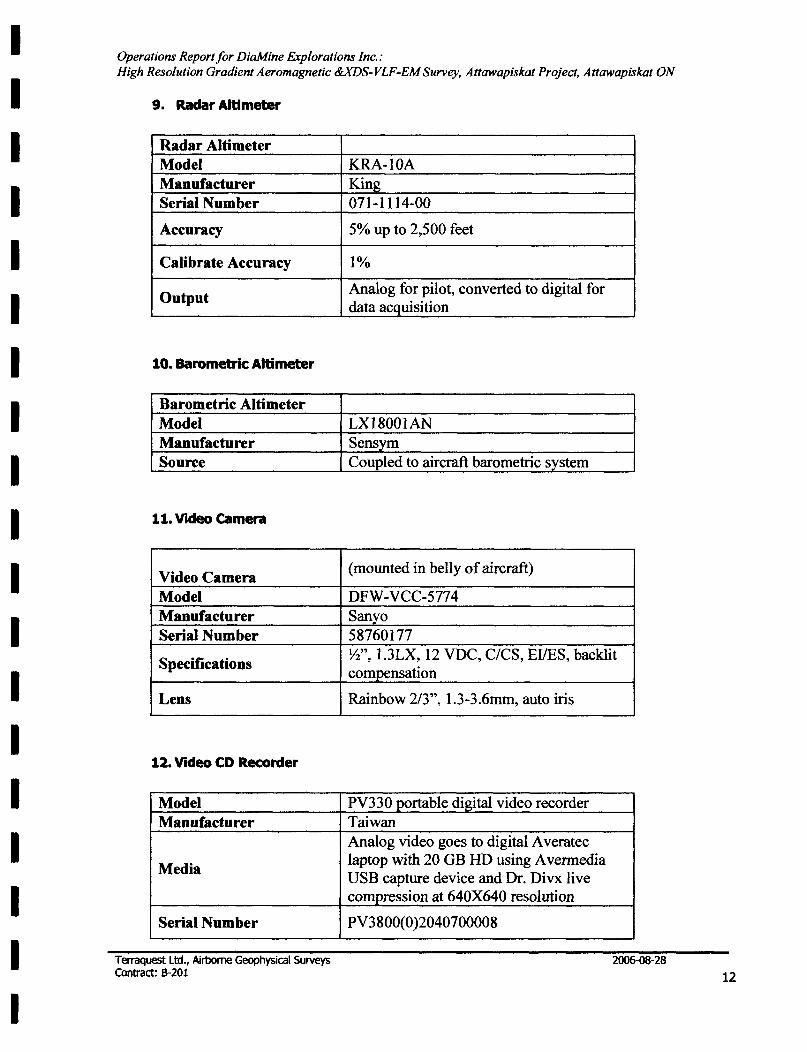
9. Radar Altimeter
Radar Altimeter Model Manufacturer Serial Number
Accuracy
Calibrate Accuracy
Output
10. Baromebic Altimeter
Barometric Altimeter Model Manufacturer Source
11. Video camera
Video Camera Model Manufacturer Serial Number
Specifications
Lens
12. Video CD Recorder
Model Manufacturer
Media
Serial Number
Terraquest Ltd., Airborne Geophysical SUrveys Contract: 8-201
KRA-lOA King 071-1114-00
5% up to 2,500 feet
1%
Analog for pilot, converted to digital for data acquisition
LX18001AN Sensym Coupled to aircraft barometric system
(mounted in belly of aircraft)
DFW -VCC-5774 Sanyo 58760177 W', 1.3LX, 12 VDC, C/CS, EVES, backlit com~nsation
Rainbow 2/3", 1.3-3.6mm, auto iris
PV330 portable digital video recorder Taiwan Analog video goes to digital A veratec laptop with 20 OB HD using A vermedia USB capture device and Dr. Divx live comJ>ression at 640X640 resolution
PV3800(0)2040700008
2006-08-28
12
I I I I I I I I I I I I I I I I I I I
Operations Report/or DiaMine Explorations Inc.: High Resolution Gradient Aeromagnetic &XDS-VLF-EM Survey, Attawapiskat Project, Attawapiskat ON
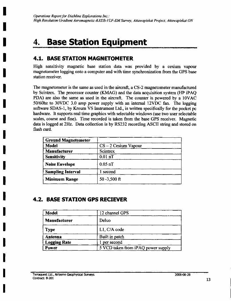
4. Base Station Equipment lUI gmws
4.1. BASE STATION MAGNETOMETER High sensitivity magnetic base station data was provided by a cesium vapour magnetometer logging onto a computer and with time synchronization from the GPS base station receiver.
The magnetometer is the same as used in the aircraft, a CS-2 magnetometer manufactured by Scintrex. The processor counter (KMAG) and the data acquisition system (HP iPAQ PDA) are also the same as used in the aircraft. The counter is powered by a 1 OV AC 50/60hz to 30VDC 3.0 amp power supply with an internal 12VDC fan. The logging software SDAS-1, by Kroum VS Instrument Ltd., is written specifically for the pocket pc hardware. It supports real time graphics with selectable windows (use two user selectable scales, coarse and fine). Time recorded is taken from the base GPS receiver. Magnetic data is logged at 2Hz. Data collection is by RS232 recording ASCII string and stored on flash card.
Ground Magnetometer Model CS - 2 Cesium Vapour Manufacturer Scintrex Sensitivity 0.01 nT
Noise Envelope 0.05 nT
Samplinl( Interval 1 second
Minimum Range 50 -3,500 ft
4.2. BASE STATION GPS RECIEVER
Model
Manufacturer
Type
Antenna Logging Rate Power
Terraquest Ltd., Airborne Geophysical Surveys Contract: 8-201
12 channel GPS
Deluo
L1, CIA code
Built in patch 1Qer second 5 VCD taken from iP AQ power supply
2006-08-28
13
I I I I I I I I I I I I I I I I I I I
Operations Report for DiaMine Explorations Inc.: High Resolution Gradient Aeromagnetic &xDS-VLF-EM Survey, Attawapiskat Project, Attawapiskat ON
5. TESTS AND CALIBRATIONS ••
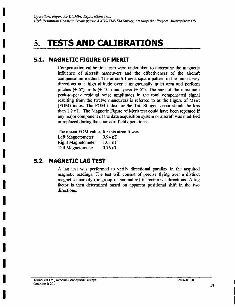
5.1. MAGNETIC FIGURE OF MERIT
5.2.
Compensation calibration tests were undertaken to determine the magnetic influence of aircraft maneuvers and the effectiveness of the aircraft compensation method. The aircraft flew a square pattern in the four survey directions at a high altitude over a magnetically quiet area and perform pitches (± 5°), rolls (± 10°) and yaws (± 5°). The sum of the maximum peak-to-peak residual noise amplitudes in the total compensated signal resulting from the twelve maneuvers is referred to as the Figure of Merit (FOM) index. The FOM index for the Tail Stinger sensor should be less than 1.2 nT. The Magnetic Figure of Merit test could have been repeated if any major component of the data acquisition system or aircraft was modified or replaced during the course of field operations.
The recent FOM values for this aircraft were: Left Magnetometer 0.94 nT Right Magnetometer 1.03 nT Tail Magnetometer 0.76 nT
MAGNETIC LAG TEST A lag test was performed to verify directional parallax in the acquired magnetic readings. The test will consist of precise flying over a distinct magnetic anomaly (or group of anomalies) in reciprocal directions. A lag factor is then determined based on apparent positional shift in the two directions.
Terraquest Ltd., Airborne Geophysical Surveys Contract: 8-201
2006-08-28
14
I I I I I I I I I I I I I I I I I I I
Operations Report for DiaMine Explorations Inc.,' High Resolution Gradient Aeromagnetic &xDS-VLF-EM Survey, Attawapiskat Project, Attawapiskat ON
6. LOGISTICS , W til
_ .. I
6.1. PERSONNEL The contractor supplied the following properly qualified and experienced personnel to carry out the survey and to process, compile and report on the data:
Field C-GGLS:
Office:
Pilot Operator
Senior Geophysicist Manager
6.2. FIELD OPERATIONS
Brian Knapp Gabe Genier
Al Duffy Charles Barrie
The crew arrived in Fort Albany Tuesday July 25,2006 and secured accommodations and the following day set up the base station. The survey was flown successfully in 5 flights, GLS856 to GLS860 over 6 days from July 26h to 31 st, including all calibration tests and re-flights. Wind and rain hindered production to varying degrees on three days.
6.3. BASE OF OPERATIONS The closest base was Attawapiskat but no lodging could be obtained there, hence the main base of operations was in Fort Albany, Ontario. The base station (combined high sensitivity magnetic and GPS) was set up at the airport well away from cultural interference.
6.4. ACCOMMODATION Accommodations for the crew were the responsibility and cost of Terraquest. The crew was housed at the Loon Lodge telephone 705-278-1169. High speed internet was available at the Band Office by special pennission.
6.5. FUEL Fuel and fuel positioning if necessary for the entire survey was the responsibility and cost ofTerraquest. Fuel was available at Fort Albany.
Terraquest Ud., Airborne Geophysical Surveys Contract: 8-201
2006-08-28
15
I I I I I I I I I I I I I I I I I I I
Operations Report for DiaMine Explorations Inc.: High Resolution Gradient Aeromagnetic &XDS- VLF-EM Survey, Attawapiskat Project, Attawapiskat ON
7. DATA PROCESSING
7.1. DATA QUALITY CONTROL
The data were transmitted via an FTP site to Terraquest Ltd. where it was reviewed thoroughly for quality control and tolerances on all channels. This included any corrections to the flight path, making flight path plots, importing the base station data, creating a database on a flight-by-flight basis, and posting the data. All data were checked for continuity and integrity. Any errors or omission or data beyond tolerances were flagged for re-flight and the crew was notified by return FTP transmission, ready for their flight in the morning.
7.2. FINAL DATA PROCESSING
The final processing performed by senior geophysicist Al Duffy, involved tie line leveling in the standard manner by tying the survey lines to the tie lines using GEOSOFT software. The total field was gridded and micro-leveled in the Fourier domain (generally less than 1 nT corrections) to reduce any linear noise along the flight path without degrading the geologic signal. The vertical magnetic gradient was calculated from the final processed total magnetic field gridded data. The fmalleveled datasets were gridded and were contoured.
The measured horizontal gradient was obtained as follows. a) The raw transverse gradient is the value from the left sensor minus the value from the right sensor divided by their separation. b) The raw longitudinal gradient is the difference between the tail sensor and the average of the left and right sensors, and divided by the longitudinal separation. c) The raw gradients are then DC shifted to account for line heading effects and differences in the sensors. d) The gradients are then rotated from aircraft centric components to true geographic components; these are the fmal North and East gradients, which are listed in the database.
The XDS-VLF-EM data using the Cutler Maine to Seattle WA range of transmitter signals were rescaled (where required), low pass filtered and then DC shift corrected.
All maps are 1:20,000 scale on paper with both latllong and VTM coordinates, and two copies of each map have been prepared. The following maps were plotted:
• Map of Total Magnetic Intensity Contoured Colour Image and Digital Topo Base, • Map of Total Magnetic Intensity Contours and Digital Topo Base, • Map of Vertical Magnetic Gradient Contoured Colour Image with Flight Path and
Digital Topo Base,
Terraquest Ltd., Airborne Geophysical Surveys Contract: 8-201
2006-08-28
16
I I I I I I I I I I I I I I I I I I I
Operations Report for DiaMine Exp/orations Inc.: High Resolution Gradient Aeromagnetic &XDS-VLF-EM Survey, Attawapiskat Project, Attawapiskat ON
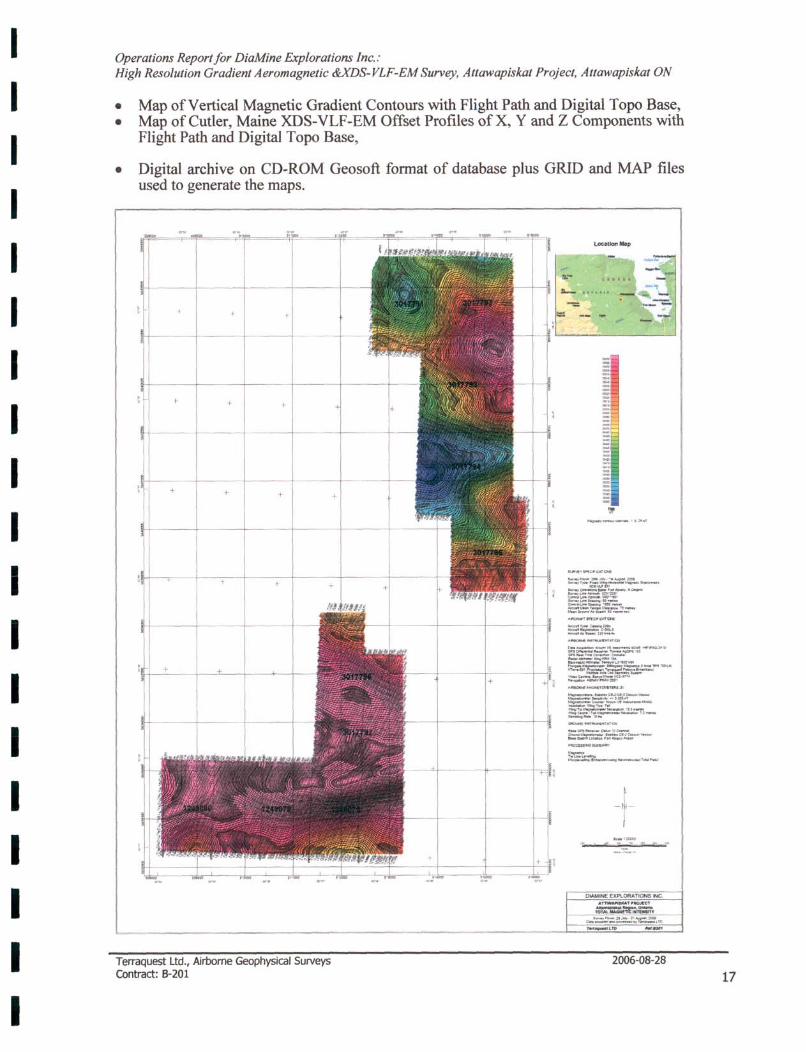
• Map of Vertical Magnetic Gradient Contours with Flight Path and Digital T opo Base, • Map of Cutler, Maine XDS-VLF-EM Offset Profiles of X, Y and Z Components with
Flight Path and Digital T opo Base,
• Digital archive on CD· ROM Geosoft format of database plus GRID and MAP files used to generate the maps.
TerraQuest Ltd., Airborne Geophysical Surveys Contract: 8-201
Loc:attonMip
-, -
... ~l_r'CATQIl
==-~ ... ___ ,.". ... '001 t.Io ............. "'_W_I(>Itot""'_~
:;==:'="T=-~~
==--='-*'~ ~~=~~~ __ ce.......,....., ==-....!:"",..:-:»i~ "'_~~~"l
...-_a..:~.-._ ......----...,. 4' •. , =-"~f":""'W--.... ~ _____ Iooc_ ,,~_ .... _ ., .. .....-.-.....- J:_ -....,_ l. Ho
-1-.... '-, ........ - <>< -
~=-""::~..,""==lrC> r.".....,Lrp ,.."...
2006-08-28
17
I I I I I I I I I I I I I I I I I I I
Operations Report for DiaMine Explorations Inc.,' High Resolution Gradient Aeromagnetic &XDS-VLF-EM Survey, Attawapiskat Project, Attawapiskat ON
8. AEROMAGNETIC INTERPRETATION
8.1. INTRODUCTION The interpretation of the aero magnetic data was subcontracted to Scott Hogg & Associates. This has involved further processing utilizing gradient tensor (GT) techniques to produce maps of GT-Total Magnetic Field, GT-Calculated Vertical Gradient, GT -Shallow Magnetic Component (profiles) and Aero Magnetic Interpretation. The following is provided by Scott Hogg & Associates.
8.2. GEOLOGY The survey area, southwest of the town of Attawapiskat, is about 20 kIn SSE of the Victor kimberlite that is under development by De Beers Canada. Other kimberlites, discovered by De Beers, and closer to the property, are the Alpha and India kimberlites of unknown economic potential. In this region the Archean basement is overlain by 300 to 400 metres of Paleozoic sedimentary rock that is in turn capped by 10 to 50 metres of glacial till. The kimberlites, cited above, have penetrated fully through the Paleozoic section. About 60 kIn to the west of this area are the Kyle series of kimberlites discovered by Spider and KWG Resources. These pipes are considerably older than the De Beers discoveries and do not penetrate the Paleozoic rocks. They lie at depths of 40 to 140 metres below surface.
8.3. SHALLOW MAGNETIC COMPONENT
The Paleozoic sedimentary rocks are predominantly limestones, with typically no magnetic signature. As a result, the magnetic map is composed of two principal anomaly sources; the Archean rocks at depth and the kimberlites and glacial tills at surface. The anomalies arising from the deeper rocks are broad with long wavelengths and those arising from near surface are sharper with short wavelengths. A two dimensional Fourier Transform filtering process was applied to the total magnetic field grid to extract the detail associated with the shallower magnetic sources. This map designated the Shallow Magnetic Component Map, presents clearly the magnetic detail arising from all shallow magnetic sources.
8.4. KIMBERLITE EXPECTATIONS
The typical kimberlite pipe is commonly described as carrot shaped, near vertical in orientation, tapering with depth and presenting a roughly circular cross section at surface. Kimberlite pipes range in size from tens of metres to hundreds of metres in diameter. A typical size is in the order of 100 to 200 metres diameter, large enough to be detected by a low-level aeromagnetic survey. The susceptibility of kimberlite ranges from very low
Terraquest Ltd., Airborne Geophysical SUrveys Contract: 8-201
2006-08-28
18
I I I I I I I I I I I I I I I I I I I
Operations Reportfor DiaMine Explorations Inc.: High Resolution Gradient Aeromagnetic &XDS-VLF-EM Survey, Attawapiskat Project, Attawapiskat ON
values, almost zero, to values in the order of 0.005 emu. Kimberlites with higher susceptibilities may exist but would be an exception to the norm. In areas with a relatively steep magnetic inclination (>60 degrees from horizontal) the top surface of the pipe is the principal source of the anomaly. If the pipe tapers rapidly with depth the effective vertical thickness of the pipe is reduced and the bottom contact of the anomaly will have a negative impact and reduce the observed anomaly amplitude. For this reason, the most pronounced anomaly is expected over the root zone of a pipe and perhaps no anomaly will be evident over a sill or crater edge. A pipe with steeply dipping crater walls extending down to the root provides the optimum form for generating a magnetic anomaly. Kimberlite dykes, although they may be steeply dipping and of great depth extent are often too narrow, less than 10 metres, to create a significant airborne response.
While the locations of kimberlite fields may be influenced by major, crustal scale geologic conditions; the location of individual pipes, at surface, usually bears little relationship to the local host geology. Kimberlites often appear as random local events, at odds with the surrounding geologic and magnetic context. This concept of being at odds with their immediate surrounds is referred to as "isolation" or "singularity". This description can be applied to a strong circular anomaly surrounded by a quiet background as well as an anomaly on or adjacent to a dyke. This consideration of contrast or isolation is subjective but useful for kimberlite anomaly identification. In an active magnetic area such as a greenstone belt, there will be many small magnetic anomalies that are due to local small formations of volcanic rock that is not kimberlite. A small anomaly within a large magnetically quiet area is more unexpected geologically and thus deserves greater consideration as a possible kimberlite pipe.
The anomaly selection process is therefore directed towards anomalies that have a form suggestive of an intrusive, ideally several hundred metres in diameter with a low to moderate susceptibility. There are many such features in a typical map and the apparent isolation or singularity of the anomaly is a qualitative but important criterion. The amplitude of a magnetic anomaly from a kimberlite scale source is a function of both size and magnetic susceptibility. A small body with high iron content can produce the same amplitude as a larger body with lower iron content. Magnetic modelling can help distinguish between the effects of width and magnetic susceptibility. As the width of a source decreases and the susceptibility increases the source becomes increasingly unlikely to be kimberlite. If the susceptibility is low to moderate, kimberlite becomes a possible source but so too do a wide variety of rocks. The magnetic method cannot identify kimberlite but only indicate anomalies that have magnetic attributes in line with those commonly associated with known pipes.
8.5. DISCUSSION There is no evidence in the Total Field Magnetic Map of a deeper anomaly that could be considered suggestive of a Kyle type kimberlite. The Shallow Magnetic Component Map, especially towards the north, indicates numerous anomalies with amplitudes of about +/-2 nT. Many of these are aligned WNW-ESE in a direction, believed to be perpendicular to glacial ice movement. It is very likely that these linear features are associated with
Terraquest Ltd., Airborne Geophysical Surveys Contract: 8-201
2006-08-28
19
I I I I I I I I I I I I I I I I I I I
Operations Reportfor DiaMine Explorations Inc.: High Resolution Gradient Aeromagnetic &XDS-VLF-EM Survey, Attawapiskat Project, Attawapiskat ON
to glacial ice movement. It is very likely that these linear features are associated with deposits of gravel along the ice front. Glacial gravel typically contains a magnetic fraction that can create a weak magnetic anomaly; positive in areas of increased thickness or negative where locally thinner. In addition to the WNW -ESE trend noted above there are also other trends, not always linear. It is possible that these are associated with glacial out-wash or paleo-drainage that has eroded the Paleozoic surface and created channels that would lead a thicker till cover. There are also some suggestions of circular forms, such as those near 315,000 E and 5,839,000 N. While the dimensions are not unreasonable for kimberlite it is strongly suspected that the source is related to glacial till.
1.6. RECOMMENDATIONS On the basis of the aeromagnetic data alone no follow-up is recommended. If other exploration techniques suggest a kimberlite may be present within the area, the magnetic survey results do not rule out the possibility of an essentially non-magnetic pipe.
Terraquest Ltd., Airborne Geophysical Surveys Contract: 8-201
August 28, 2006
itted,
2006-08-28
I I I I I I I I I I I I I I I I I I I
Operations Report/or DiaMine Explorations Inc.: High Resolution Gradient Aeromagnetic &xDS-VLF-EM Survey, Attawapiskat Project, Attawapiskat ON
1.7. CERTIFICATION OF QUALIFICATION
I, Robert Leslie Scott Hogg, of the City of Toronto, Ontario, Canada, certify that:
I reside at 1 Deepwood Crescent, Toronto, Canada.
I have worked as a geophysicist since 1970.
1 have worked for:
1970 1972-1980 1980-1981
1981-1992
1998-present
Selco Mining as a staff geophysicist Northway Survey Corporation as Manager and Chief Geophysicist Questor Surveys Ltd. as General Manager of the Magnetics and Radiometrics Division Aerodat Ltd. as Vice President Consultant to High-Sense Geophysics, and various mining exploration companies. Scott Hogg & Associates Ltd., geophysical services, as president and senior geophysicist.
I am a graduate of the University of Toronto, 1970, with a B.A.Sc. degree in engineering science, geophysics option.
I am a Professional Engineer of Ontario.
I am a member of the Society of Exploration Geophysicists and the European Association of Geoscientists and Engineers.
I do not have any financial interest in the project or properties associated with this report.
Terraquest Ud., Airborne Geophysical Surveys Contract: 8-201
Dated at Toronto, Ontario This 28th day of August, 2006
I/~;;-R.L. Scott Hogg, B.A.Sc., P.Eng.
2006-08-28
I I I I I I I I I I I I I I I I I I I
Operations Report for DiaMine Explorations Inc.: High Resolution Gradient Aeromagnetic &XDS- VLF-EM Survey, Attawapiskat Project, Attawapiskat ON
9. SUMMARY
An airborne tri-sensor, high sensitivity magnetic and passive XDS-VLF-EM survey was performed at 70 metre mean terrain clearance, 50 metre survey line intervals with 025 degree azimuth, 1 kilometre control line interval with 000 degrees azimuth, and with data sample points at 6 metres along the flight lines. A high sensitivity magnetic and a GPS base station located in Fort Albany, ON recorded the diurnal magnetic activity and reference GPS time during the survey for adherence to survey tolerances.
The data were subjected to final processing to produce 2 copies each of colour images of the following maps: a) contours of total magnetic intensity, b) contours of calculated vertical magnetic gradient, and c) contours of the XDS-VLF -EM signal. All data have been archived on a CD-ROM as Geosoft database (GDB) and ASCII database plus all MAP and GRID files used to make the maps.
Enhanced processing involving gradient tensor (GT) techniques plus aeromagnetic interpretation was subcontracted to Scott Hogg & Associates. Based on aeromagnetic only, no follow-up is recommended however this does not exclude the possibility of a non-magnetic kimberlite.
1- les Barrie, M.Sc. Vice President Terraquest Ltd.
August 28, 2006
Terraquest Ltd., Airborne Geophysical Surveys Contract: 8-201
2006-08-28
22
I I I I I I I I I I I I I I I I I I I
Operations Report for DiaMine Explorations Inc.: High Resolution Gradient Aeromagnetic &xDS-VLF-EM Survey, Attawapiskat Project, Attawapiskat ON
10. APPENDICES
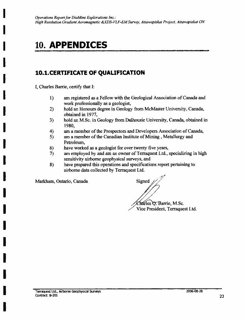
IO.I.CERTIFICATE OF QUAUFICATION
I, Charles Barrie, certify that I:
1) am registered as a Fellow with the Geological Association of Canada and work professionally as a geologist,
2) hold an Honours degree in Geology from McMaster University, Canada, obtained in 1977,
3) hold an M.Sc. in Geology from Dalhousie University, Canada, obtained in 1980,
4) am a member of the Prospectors and Developers Association of Canada, 5) am a member of the Canadian Institute of Mining, Metallurgy and
Petroleum, 6) have worked as a geologist for over twenty five years, 7) am employed by and am an owner of Terraquest Ltd., specializing in high
sensitivity airborne geophysical surveys, and 8) have prepared this operations and specifications report pertaining to
airborne data collected by Terraquest Ltd.
Markham, Ontario, Canada
Terraquest Ltd., Airborne Geophysical Surveys Contract: IH01
les . arrie, M.Sc. Vice President, Terraquest Ltd.
2006-08-28
23
I I I I I I I I I I I I I I I I I I I
Operations Report for DiaMine Explorations Inc.: High Resolution Gradient Aeromagnetic &XDS~VLF~EM Survey, Attawapiskat Project, Attawapiskat ON
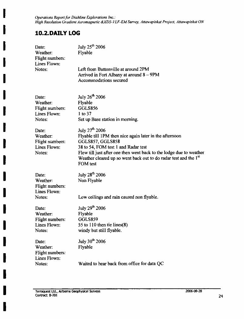
10.2. DAILY LOG
Date: Weather: Flight numbers: Lines Flown: Notes:
Date: Weather: Flight numbers: Lines Flown: Notes:
Date: Weather: Flight numbers: Lines Flown: Notes:
Date: Weather: Flight numbers: Lines Flown: Notes:
Date: Weather: Flight numbers: Lines Flown: Notes:
Date: Weather: Flight numbers: Lines Flown: Notes:
July 25th 2006 Flyable
Left from Buttonville at around 2PM Arrived in Fort Albany at around 8 - 9PM Accommodations secured
July 26th 2006 Flyable GGLS856 I to 37 Set up Base station in morning.
July 27th 2006 Flyable till 1 PM then nice again later in the afternoon GGLS857, GGLS858 38 to 54, FOM test 1 and Radar test Flew till just after one then went back to the lodge due to weather Weather cleared up so went back out to do radar test and the 1 st
FOMtest
July 28th 2006 Non Flyable
Low ceilings and rain caused non flyable.
July 29th 2006 Flyable GGLS859 55 to 110 then tie lines(8) windy but still flyable.
July 30th 2006 Flyable
Waited to hear back from office for data QC
Terraquest Ltd., Airborne Geophysical Surveys Contract: 8-201
2006-08-28
24
I I I I I I I I I I I I I I I I I I I
Operations Report/or DiaMine Explorations Inc.: High Resolution Gradient Aeromagnetic &xDS-VLF-EM Survey, Attawapiskat Project, Attawapiskat ON
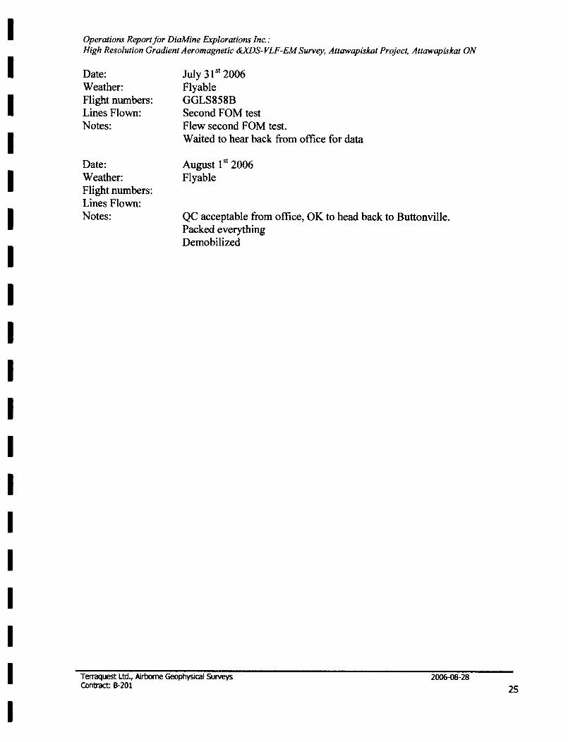
Date: Weather: Flight numbers: Lines Flown: Notes:
Date: Weather: Flight numbers: Lines Flown: Notes:
July 31 st 2006 Flyable GGLS858B Second FOM test Flew second FOM test. Waited to hear back from office for data
August 1 st 2006 Flyable
QC acceptable from office, OK to head back to Buttonville. Packed everything Demobilized
Terraquest Ltd., Airborne Geophysical Surveys Contract: 8-201
2006-08-28
25


![CONTRACT INTERPRETATION ENFORCEMENT COSTS: AN …2019] CONTRACT INTERPRETATION ENFORCEMENT COSTS 1013 I. INTRODUCTION Contract interpretation is one of the most important topics in](https://img.pdfslide.us/doc/110x75/5e720267e69fa76e540166b7/contract-interpretation-enforcement-costs-an-2019-contract-interpretation-enforcement.jpg)