Embed Size (px)
Citation preview

i -
’ SUB-RECORDER RECEIVED
M.R. # ..................._ $......-... 1 VANCOUVER, B.C.
1991 GEOLOGICAL AND GEOCHEMICAL REPORT
ON THE SCUD RIVER PROJECT
Located in the Galore Creek Area Liard Mining Division
NTS 104G/4E,SE,6W 57’ 15‘ North Latitude
131” 33‘ West Longitude
-prepared for- CONSOLIDATED GOLDWEST RESOURCES LTD.6)
- E Q w d w o m
September, 1991 w m 0 4
-prepared by- 0 M
Robert Falls, Geologist
1991 GEOLOGICAL AND GEOCHEMICAL REPORT ON THE SCUD RIVER PROJECT
1.0 2.0 3.0 4.0
4.1 4.2
5.0 6.0
6.1 6.2
7.0 8.0
TABLE OF CONTENTS
INTRODUCTION LIST OF CLAIMS LOCATION, ACCESS AND GEOGRAPHY PROPERTY MINING HISTORY
Previous Work 1991 Work Program
REGIONAL GEOLOGY PROPERTY GEOLOGY AND MINERALIZATION
Geology Mineralization
GEOCHEMISTRY DISCUSSION
APPENDICES
Appendix A Bibliography Appendix B Statement of Expenditures Appendix C Rock Descriptions Appendix D Trench Maps Appendix E Cumulative Frequency Distributions
Appendix F Certificates of Analysis Appendix G Statement of Qualifications
for Soil Geochemistry
LIST OF FIGURES
Figure Figure Figure Figure Figure Figure Figure Figure Figure Figure Figure Figure
1 2 3 4 5 6 7 8 9 10 11 12
Location Map Claim Map Regional Mineral Occurrence Map Regional Geology Geology and Geochemistry:South Sheet Geology and Geochemistry:North Sheet Twilight grid: Geology and Geochemistry Alder showing: Cross-section Twilight grid: Goldfsilver in Soils Twilight grid: CopperfArsenic in Soils Twilight grid: LeadIZinc in Soils Twilight grid: Soil Compilation Map
LIST OF TABLES
Table 2.0.1 Claim Data
Paqe .l. .l. .2.
. 3 .
. 4 .
.5.
. 8 .
.9. .lo. .13.
Following Paqe .l. .l. . 3 . .5. . Pocket. . Pocket.
.Pocket.
.Pocket.
.Pocket.
.Pocket. . Pocket. . Pocket.
Page .l.
.lo.
.11.
Table 6.2.1 Alder Showing: Significant Rock
Table 7.0.1 Silt Sampling Results Table 7.0.2 Anomalous Levels for Soil Geochemistry .12.
Sample Results
tqu i ty Engineering Ltd -

1.0 INTRODUCTION
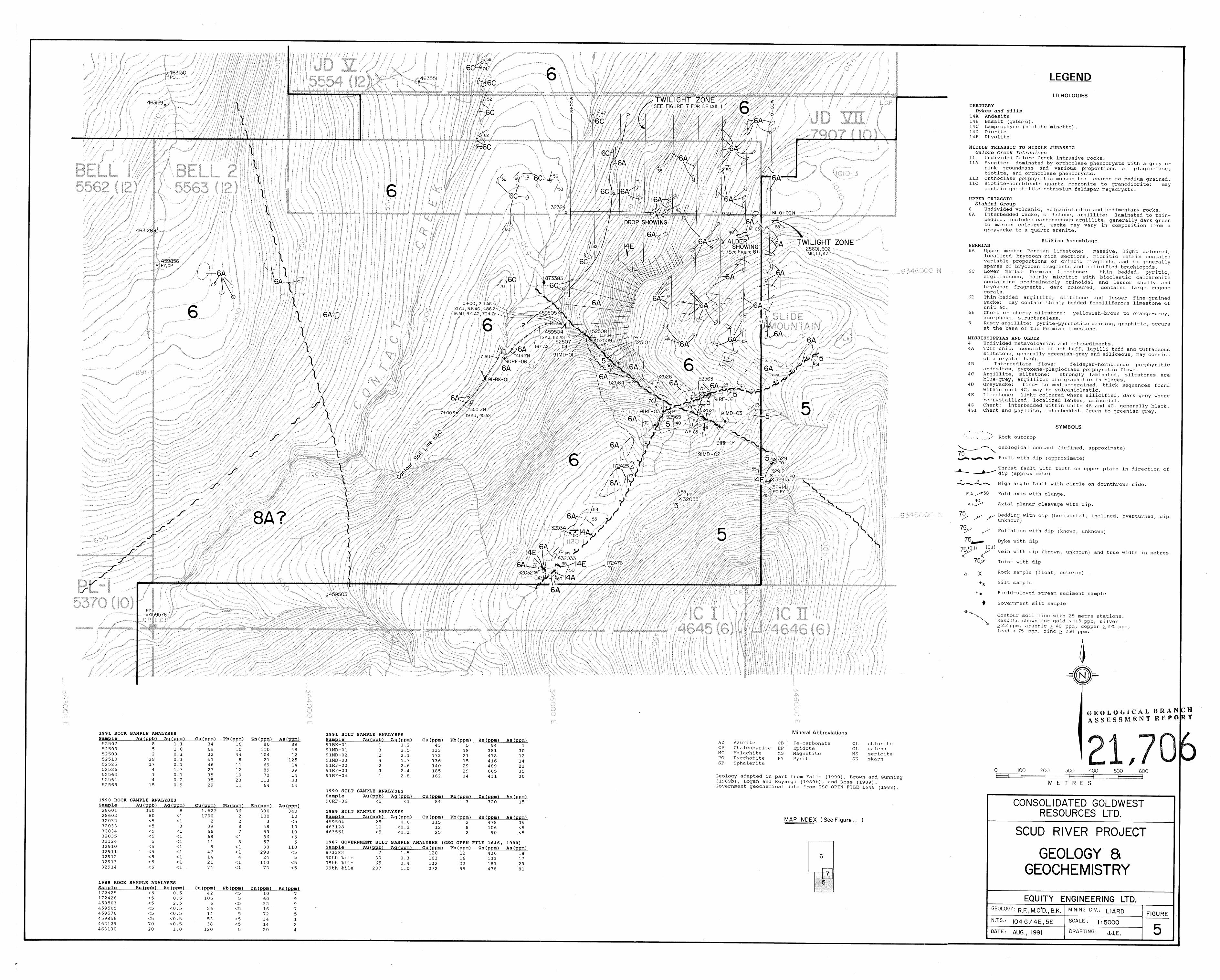
The Scud River property encompasses the JD I-VII, Bell 1-2, PL-1 and CB 1-11 claims, which were staked in 1988, 1989 and 1990 to cover favourable geology, geochemistry and sulphide-rich float in the Scud River drainage, located approximately 180 kilometres northwest of Stewart in northwestern British Columbia (Figure 1). Exploration programs on the property from 1988 to 1990 resulted in the discovery of gold-bearing skarn float at the toe of the Rugose Glacier and several gold-bearing zones of limited extent across the property. Anomalous soil geochemistry from 1990 suggested that the Twilight Zone, a polymetallic sulphide zone on the RB 11 claim, may extend onto the adjacent Bell 2 claim of the Scud River property.
An exploration program, consisting of geological mapping, prospecting and soil sampling, was carried out on the Bell 2, JD V and JD VII claims of the Scud River property during July 1991. The intent of the program was to determine whether the Twilight zone extends onto the Scud River property. Equity Engineering Ltd. conducted this program for Consolidated Goldwest Resources Ltd. and has been retained to report on the results of the fieldwork.
2.0 LIST OF CLAIMS
Records of the British Columbia Ministry of Energy, Mines and Petroleum Resources indicate that the claims listed in Table 2.0.1, all of which are situated in the Liard Mining Division (Figure 2), are owned 49% by Pass Lake Resources Ltd. and 51% by Consolidated Goldwest Resources Ltd.. Separate documents indicate that they are beneficially owned by Pass Lake Resources Ltd. while Consolidated Goldwest Resources Ltd. earns its interest.
TABLE 2.0.1 CLAIM DATA
Claim Record NO. of Record Expiry Name Number Units Date Year JD I 4641 20 June 13, 1988 1993 JD I1 4642 20 June 13, 1988 1994 JD I11 5552 20 Dec. 9, 1988 1994 JD IV 5553 20 Dec. 9, 1988 1994 JD V 5554 20 Dec. 9, 1988 1994 JD VI 5555 20 Dec. 9, 1988 1995
Bell 1 5562 20 Dec. 9, 1988 1994 Bell 2 5563 20 Dec. 9, 1988 1995 PL- 1 5370 20 OCt.11, 1988 1995 CB I 6521 20 oct. 4, 1989 1994 CB I1 6522 - 16 OCt. 5, 1989 1993
JD VII 7907 5 oct. 4, 1990 1991
221
Equity Engineering Ltd. -

I
PROPERTY LO CAT I0 N
Km 0 100 200 300 400 500 Km
MILES 0 50 100 200 300 MILES
CONSOLIDATED GOLDWEST RESOURCES LTD.
SCUD RIVER PROJECT LOCATION MAP
BRITISH COLUMBIA EQUITY ENGINEERING LTD.
1 N.T.S.: 104G/4E,SE SCALE: A S SHOWN
DATE: SEPT.. 1991 REVISED:

BRITISH COLUMBIA EQUITY ENGINEERING LTD.
F X E I MINING DIV.: LIARD DRAWN: N .T. S . :Io4 G/?y$&4k y6w I SCALE: I:50000 DATE: SEPT., 1991 REVISED: 2

The CB I claim overlies the previously staked Nunatak 1 claim, reducing by half its effective size. The JD VII claim was staked in October 1990 to cover a fraction between the JD and Bell claim groups. The positions of all legal corner posts for the claims have been verified by Equity Engineering Ltd. personnel.
3.0 LOCATION, ACCESS AND GEOGRAPHY
The JD I-VII, Bell 1-2, CB 1-11 and PL-1 claims are located within the Coast Range Mountains approximately 180 kilometres northwest of Stewart and 75 kilometres southeast of Telegraph Creek in northwestern British Columbia (Figure 1). They lie within the Liard Mining Division, cantered at 57' 15' north latitude and 131' 33' west longitude.
Access to the Scud River property during the 1991 exploration program was provided by helicopter from the Galore Creek camp and airstrip, which is located approximately fifteen kilometres to the southeast. During the field season, fixed-wing aircraft fly charters from Smithers to the Galore Creek airstrip direct or via the Bronson airstrip. The Galore Creek airstrip is 425 metres in length, limiting the size of the aircraft that can be safely landed there. During the 1991 season, the Galore Creek camp was serviced by a Turbo Otter, based out of Smithers. The Scud River airstrip, located sixteen kilometres west of the property, is suitable for DC-3 aircraft.
On the Alaskan side of the border, Wrangell lies approximately 100 kilometres to the southwest and provides a full range of services and supplies, including a commercial airport. The Stikine River has been navigated by 100-ton barges upriver as far as Telegraph Creek, allowing economical transportation of heavy machinery and fuel to within sixteen kilometres of the property. During the 1960's, Kennco constructed a cat road from their Galore Creek copper-gold deposit down the south side of the Scud River to the Scud River airstrip, passing through the JD 11, 111, IV and VI claims. This cat road has not been maintained and would require extensive reconstruction before becoming useable.
The JD I to VI claims straddle the Scud River, from fifteen to twenty-two kilometres above its confluence with the Stikine River (Figure 2). The JD I and I1 claims lie mainly on the north side of the Scud River, covering the lower part of the Rugose Creek drainage, including the toe of the Rugose Glacier, a valley glacier which descends to an elevation of 1100 metres. The CB I and I1 claims extend east from JD I, covering the upper portions of the Rugose Glacier. The other claims lie mainly on the south side of the Scud River, stretching southwest up the drainage of Contact Creek. Topography is rugged, typical of mountainous and glaciated terrain, with elevations ranging from 200 metres on the Scud River to over 1770 metres on an unnamed peak on the Bell 1 claim.

3
Lower slopes are covered by a mature forest of hemlock, spruce and balsam fir with a dense undergrowth of devil's club, alder and huckleberry. Above treeline, which occurs at approximately 1100 metres, the creek beds and slopes are covered by dense slide alder and willow growth. Steeper slopes are covered by short heather and other alpine vegetation. Northerly-facing slopes are covered with permanent snowfields at higher elevations.
The Scud River property lies in the wet belt of the Coast Range Mountains. Annual precipitation ranges from 190 to 380 centimetres (Kerr, 1948b). Except during July, August and September, precipitation at higher elevations falls mainly as snow, with accumulations reaching three metres or more. Both summer and winter temperatures are moderate, ranging from -5OC in the winter to 2OoC in the summer months.
4.0 PROPERTY MINING HISTORY
4 . 1 Previous Work
The Galore Creek district was extensively explored for its copper potential throughout the 1960's (Figure 3), following the discovery in 1955 of the Galore Creek copper-gold porphyry deposit, whose Central Zone hosts reserves of 125 million tonnes grading 1.06% copper and 400 ppb gold (Allen et al, 1976). Kennecott is currently updating its feasibility study on the Galore Creek deposit, incorporating significant gold and copper results from drilling in recent years. Several major mining companies conducted regional mapping and silt sampling programs over the entire Galore Creek area, and the Copper Canyon copper-gold porphyry, estimated by Consolidated Rhodes (1991) at 35.7 million tonnes grading 0.75% copper and 1.17 g/tonne (0.034 ozfton) gold was discovered eight kilometres east of the Central Zone.
In the early 1980's, Teck Corp. conducted regional reconnaissance for gold throughout the area, and delineated 185,000 tonnes of reserves grading 4.11 grams gold per tonne on the Paydirt deposit (Holtby, 1985), which is located approximately twenty kilometres south of the Scud River property. Significant precious metal occurrences were also discovered on each of the Trophy, Trek, Icy, PL 7-13 and Jack Wilson properties during the 1988, 1989 and 1990 field seasons (Figure 3). In each case, these properties had been explored for copper during the 1960's, but had never received due attention for their gold potential.
During September of 1988, Pass Lake Resources Ltd. carried out a limited exploration program of prospecting, stream and soil geochemistry on the JD I and I1 claims. Three of the four field- sieved stream sediment samples taken from Rugose Creek were highly anomalous, with 1850, 3720 and 700 ppb gold. Five of the twelve

4
rock samples taken from the JD claims returned values in excess'of 3000 ppb gold (Awmack, 1989).
Based upon these results, Consolidated Goldwest Resources Ltd. optioned the Scud River property in 1989 and carried out a property-wide reconnaissance exploration program that fall. A total of 11 field-sieved stream sediment samples, 22 silt samples, 67 soil samples and 82 rock samples were taken. The gold-bearing sulphide float discovered in 1988 on Rugose Creek was traced to gossanous limestone cliffs east of the JD I claim, and the CB I and I1 claims were staked in an attempt to cover this source. Gold- bearing mineralization of limited extent was found in place on the JD I, JD 111, JD V and PL-1 claims in a variety of structural and lithological settings (Ross, 1989).
In 1990, a further 8 silt samples, 372 soil samples and 195 rock samples were taken from the Scud River property by Consolidated Goldwest. A soil geochemical grid was established near the confluence of Contact Creek and the Scud River to provide mapping control and geochemical information in a poorly exposed area where a 1989 rock sample returned a value of 3550 ppb gold. Chip sampling failed to reproduce this value. Two contour soil lines were run on the Bell 2 claim in an attempt to trace the Twilight Zone, a sulphide-bearing horizon which outcrops on the adjacent RB 11 claim, onto the Scud River property (Falls, 1990).
4.2 1991 W ~ r k Program
During July 1991, Consolidated Goldwest carried out additional exploration on the Scud River property. The main focus of this program was to trace the Twilight Zone west onto the Bell 2 claim. During the course of this program 10 silt samples, 3 3 0 soil samples and 67 rock samples were taken. All samples were analyzed geochemically for gold and 31 elements by ICP. Samples with greater than 1000 ppb gold, 100 ppm silver or 10,000 ppm copper, lead or zinc were assayed. Analytical certificates are attached in Appendix F.
The Twilight geochemical grid was established on the Bell 2 and JD VII claims (Figures 5 and 7). A flagged baseline extends from the Bell 2/RB 11 claim boundary due west for 800 metres. Crosslines, flagged at 100 metre intervals along the baseline, extend 400 metres towards the north and 500 metres towards the south where topography allowed. Soil samples were taken at 25 metre intervals along the baseline and crosslines. To the south of Cut Creek a contour soil line was established at an elevation of 650 metres. This line was intended to test for sulphide mineralization on that side of the creek. Wherever possible, soil samples were taken from the red-brown B horizon. Where soil development was poor, talus fines were taken.
Prospecting and detailed geological mapping were carried out
I Equity Engineering Ltd.

5
over the grid (Figure 7). Reconnaissance geological mapping and prospecting were carried out along Cut Creek and on part of the JD V claim (Figures 5 and 6). Rock samples, described in Appendix C, were taken from zones of alteration and mineralization.
5.0 REGIONAL GEOLOGY
The basis for regional geological mapping in the Stikine River area was set out by Xerr (1948b), the crew of Operation Stikine (GSC, 1957) and Souther (1972). Their work has been refined in the Galore Creek area by Brown and Gunning (1989a,b) and Logan et a1 (1989a,b) at a scale of 1:50,000.
The Galore Creek Camp lies within the Intermontane Belt, a geological and physiographic province of the Canadian Cordillera, and flanks the Coast Plutonic Complex to the west (Figure 4). At Galore Creek, the generally northwest-trending structure of the Intermontane Belt is discordantly cut across by the northeast- trending Stikine Arch which became an important, relatively positive tectonic element in Mesozoic time when it began to influence sedimentation into the Bowser Successor Basin to the southeast and into the Whitehorse Trough to the northwest (Souther et al., 1974).
Stikinian stratigraphy ranges from possibly Devonian to Jurassic, and was subsequently intruded by granitoid plutons of Upper Triassic to Eocene age. The oldest strata exposed in the Galore Creek camp are Mississippian or older mafic to intermediate volcanic flows and pyroclastic rocks (Units 4A and 4B) with associated clastic sediments (Units 4C, 4D, 4G and 4J) and carbonate lenses (Unit 4E). These are capped by up to 700 metres of Mississippian limestone with a diverse fossil fauna (Unit 4E). It appears from fossil evidence that all of the Pennsylvanian system is missing and may be represented by an angular unconformity and lacuna of 30 million years, though field relationships are complicated by faulting (Monger, 1977; Logan and Koyanagi, 1989a). Permian limestones (Units 6A, 6B and 6C), also about 700 metres thick, lie upon the Mississippian limestone but are succeeded by a second lacuna amounting to about 20 million years from the Upper Permian to the upper Lower Triassic.
Middle and Upper Triassic siliciclastic and volcanic rocks (Unit 7) are overlain by Upper Triassic Stuhini Group siliciclastic (Units 8A and 8B) and volcanic (Units 8D, 8E, 8G, 8H and 81) rocks, consisting of mafic to intermediate pyroclastic rocks and lesser flows. The Galore Creek porphyry copper deposit appears from field evidence to mark the edifice of an eroded volcanic centre with numerous sub-volcanic plutons of syenitic composition. Jurassic Bowser Basin strata onlap the Stuhini Group strata to the southeast of Iskut River but, because of erosion and non-deposition, are virtually absent from the Galore Creek area.


6
The plutonic rocks follow a three-fold division (Logan and Koyanagi, 1989a,b). Middle Triassic to Late Jurassic syenitic and broadly granodioritic intrusions are partly coeval and cogenetic with the Stuhini Group volcanics and include the composite Hickman Batholith (Unit 9) and the syenites of the Galore Creek Complex (Unit 11). Jura-Cretaceous Coast Plutonic Complex intrusions (Unit 12) occur on the west side of the Galore Creek Camp, along the Stikine River, with the youngest of these intrusions occupying more axial positions along the trend of the Coast Plutonic Complex flanked by older intrusions. The youngest intrusives in the Galore Creek Camp are Eocene (quartz-) monzonitic plugs (Unit 13), felsic and mafic sills and dykes (Unit 14), and biotite lamprophyre (minette) dykes (Unit 14C).
The dominant style of deformation in the Galore Creek area consists of upright north-trending, open to tight folds and northwest-trending, southwest-verging, folding and reverse faulting in the greenschist facies of regional metamorphism. Localized contact metamorphism ranges as high as pyroxene hornfels grade; metasomatism is also noted near intrusions. Upright folding may be an early manifestation of a progressive deformation which later resulted in southwest-verging structures. Southwest-verging deformation involves the marginal phases of the Hickman Batholith and so is, at least in part, no older than Late Triassic.
Steeply dipping faults which strike north, northwest, northeast, and east have broken the area into a fault-block mosaic. North-striking faults are vertical to steeply east-dipping and parallel to the Mess Creek Fault (Souther, 1972), which was active from Early Jurassic to Recent times (Souther and Symons, 1974); northwest-striking faults are probably coeval with the north- striking faults, but locally pre-date them. East-west trending faults are vertical or steeply dipping to the north and have normal-type motion on them (i.e., north-side down), whereas northeast-striking faults are the loci of (sinistral) strike-slip motion (Brown and Gunning, 1989a).
A number of metallic deposit types have been recognized in the Galore Creek camp: porphyry copper+molybdenum+gold deposits, structurally-controlled precious metal veinlshear deposits, skarns and breccia deposits (Figure 3). Porphyry copper deposits of this area include both the alkalic Galore Creek copper-gold and calc- alkalic Schaft Creek copper-molybdenum deposits. Galore Creek, which is associated with syenitic stocks and dikes rather than a quartz-feldspar porphyry, is further contrasted from the calc- alkaline Schaft Creek in that molybdenite is rare, magnetite is common and gold and silver are important by-products. The mineralization is clearly coeval and cogenetic with the spatially associated intrusive bodies. Other porphyry copper occurrences in the Galore Creek area include the Copper Canyon, SueIAnn, Bik and Jack Wilson Creek deposits (Figure 3).
Equity Engineering Ltd. -
7
Structurally-controlled gold-silver deposits have been the focus of exploration in recent years. The vein/shear occurrences are similar throughout the Galore Creek camp in that they are mesothermal in nature, containing base metal sulphides with strong silica veining and alteration. However, it appears that the intrusive bodies associated with this mineralization fall into two classes on the basis of age and composition. These two classes are reflected in differences in the style of structures, sulphide mineralogy and associated alteration products. The intrusive types are: 1) Lower Jurassic alkaline "Galore Creek" stocks; and 2) Eocene quartz monzonite to porphyritic granodiorite intrusions. Lead isotope data from the Stewart mining camp (Alldrick et al., 1987) further supports the proposition that separate Jurassic and Tertiary mineralizing events were "brief regional-scale phenomena@#.
Structures associated with the Lower Jurassic syenites are typically narrow quartz-chlorite veins mineralized predominately with pyrite, chalcopyrite and magnetite. Examples of these structures in the Galore Creek camp include many of the discrete zones peripheral to the Galore Creek deposit and the gold-rich veins at Jack Wilson Creek. The Tertiary mineralization comprises discrete quartz veins and larger shear zones characterized by pervasive silicification, sericitization and pyritization whose total sulphide content is commonly quite low. The quartz veins contain a larger spectrum of sulphide minerals including pyrite, chalcopyrite, pyrrhotite, arsenopyrite, galena and sphalerite. Unlike the Jurassic mineralization, silver grades may be very high. A number of mineral showings discovered in the Porcupine River area, including the Paydirt deposit, are of this type.
Skarns represent a minor percentage of the precious metal- bearing occurrences in the Galore Creek camp. The mineralogy of these deposits could be influenced by the composition of the intrusion driving the hydrothermal fluids, in much the same way as described above for the structurally-controlled deposits. If the intrusives are alkalic, the skarn assemblage will be dominated by magnetite and chalcopyrite, as at the Galore Creek deposit and the Hummingbird skarn on the east side of the South Scud River.
The breccia hosted mineralization discovered in the Galore Creek camp precious metal deposits appear to be unique in style and mineralization. Three occurrences have been located in the camp: (1) the zinc-silver-gold Ptarmigan zone in the South Scud River area, (2) the copper-molybdenum-gold-silver breccia at the Trek property on Sphaler Creek and ( 3 ) the copper-bearing and magnetite breccias of the complex Galore Creek deposit. The single common denominator of each is that the zones are located along fault structures which may represent the main conduit for mineralizing fluids.

I
8
6.0 PROPERTY GEOLOGY AND MINERALIZATION
6.1 Geology
The Scud River property is underlain by Permian and older sedimentary and volcanic rocks of the Stikine Assemblage except 'in the southern part of the property where some Upper Triassic Stuhini Group sediments outcrop. Triassic to Jurassic intrusives of the Galore Creek Suite have intruded the Permian and older rocks on the Bell 1 and P1-1 claims. Eocene dykes and sills intrude Permian limestone on the Nunatak property to the east of the Scud River property and Tertiary dykes and sills intrude all rocks on the Scud River property. The stratified rocks generally strike northerly and dip toward the east but are quite variable in orientation. Geological mapping during the 1991 program was confined to the eastern parts of the Bell 2 and JD VII claims and the southern part of the JD V claim and the results of this work are described below. Figures 5 to 7 illustrate the geology of the 1991 project area. Figures 5 and 6 have been adapted from Falls (1990) and modified as a result of the 1991 mapping program.
The oldest rocks within the 1991 map area consist of a sequence of interbedded Mississippian and older sediments (Unit 4). These rocks occupy much of the eastern part of the JD V claim and are exposed along Contact Creek and on a treed ridge to the south of the Contact Creek grid (Figure 6). They generally strike easterly and dip gently towards the south. The lateral extent of subunits within this sequence is difficult to determine due .to complex interbedding and generally poor exposure. Unit 4C consists of dark grey to black, locally calcareous or graphitic, laminated argillite with lesser siltstone. It is generally interbedded with black, thickly bedded chert (Unit 4G) and massive, grey limestone (Unit 4E). Several other units are known to occur within this sequence but none of these were observed within the 1991 project area.
Unit 4 is overlain to the south by a thick sequence of Permian limestone (Unit 6). The limestones have been mapped in detail within the Twilight grid (Figure 7). Much of the grid is occupied by the upper member limestone (Unit 6A). This unit consists of light coloured , thickly bedded to massive, crinoidal limestone. Chert interbeds up to 5 centimetres thick are present locally. In the southern part of the grid the rocks strike northerly and dip moderately to steeply towards the west. In the north, strikes become easterly to northeasterly, suggesting that some folding has taken place. Several shear zones of variable orientations have been mapped and sulphide mineralization is associated with two such zones (Section 6.2).
Underlying Unit 6A is argillaceous limestone (Unit 6C). This dark coloured, thinly bedded unit is exposed in the western part
I Equity Engineering Ltd

9
of the grid. The contact appears to be conformable but the full lateral extent of Unit 6C has yet to be determined.
In the southeast corner of the Bell 2 claim rusty-weathering argillite (Unit 5) is in fault contact with the Permian limestone (Unit 6A) (Figure 5). The argillite is highly deformed, often graphitic and contains up to 10% stratiform pyrite and pyrrhotite. These rocks strike northeasterly and dip moderately towards the west. A wedge of Unit 5, apparently displaced by faulting, has been mapped within Cut Creek. The argillite unit was previously thought to be part of the Upper Triassic Stuhini Group (Unit 8A) but its deformed nature and high sulphide content is more typical of Unit 5 of the Paleozoic Stikine Assemblage.
Minor Tertiary dykes of dioritic (Unit 14D) and rhyolitic (Unit 14E) compositions have been mapped within the Twilight grid.
6 . 2 Mineralization
Numerous gold-bearing occurrences have been described previously from the Scud River property by Falls (1990), Ross (1989) and Awmack (1989). None of these were examined during the 1991 field program and they will not be described below.
The Twilight Zone, a sulphide-bearing shear zone hostedwithin limestone, is exposed in a series of trenches on the RE 11 claim, just east of the Scud River property (Figure 5). The Alder Showing is an occurrence of similar mineralization which outcrops on the Scud River property approximately 100 metres southwest of the westernmost Twilight Zone trench. The showing, located at approximately 1+00 W, 0+75 S on the Twilight grid (Figure 7), may be a continuation of the Twilight Zone as it is similar in both appearance and orientation. The Alder Showing is exposed in a vertical rock face which is illustrated in Figure 8 . Sulphide mineralization occurs mainly as discontinuous, 1 to 2 centimetre wide pyrite-sphalerite-chalcopyrite-galena stringers hosted within a 1 metre thick unit of calcareous talc schist. The schist is overlain by massive, blocky, unmineralized Permian limestone (Unit 6A). Three parallel trenches (see Appendix D) expose weathered calc-silicate schist which underlies the talc schist. This lower unit is at least 1 metre thick and is less mineralized, although disseminated pyrite and traces of chalcopyrite and malachite are present. The schistose units probably resulted from shearing and hydrothermal alteration of original limestone and the whole package is believed to represent a fault zone, striking 122' and dipping 30 to 40' towards the south. Numerous rock samples were taken from the Alder Showing and the most significant results are shown in Table 6.2.1.

10
TABLE 6.2.1 ALDER SHOWING: SIGNIFICANT ROCK SAMPLE RESULTS
sample Sample Gold Silver Copper Lead Zinc Usenic Number Tvve ( vvb (vvm) (vvm) (vvm) (v ercent ( vvm L 52505 Select 64 17.2 1993 4007 15.08% 131 52506 Chip(l.4m) 53 8.4 1557 1231 3.03% 66 52552 Grab 97 15.4 4375 2419 1.41% 35 52556 Grab 152 19.5 1.357% 76 7040ppm 11 52559 Grab 83 8.9 2256 813 2.80% 94
As can be seen from Table 6.2.1 most of the significant results are from grab or select samples of sulphide pods or stringers. Chip sample 52506 was taken across the talc schist horizon in an area containing several pyrite-sphalerite stringers but mineralization within the showing is generally spotty and the results of other chip and grab samples are not as high (Figure 8).
Select sample 52554 yielded the highest copper value of all samples taken within the Twilight grid. The sample, taken from a 10 centimetre wide quartz-chalcopyrite-pyrite-chalcocite vein at O+OO W, 1+00 S on the grid, assayed 1.964% copper with low values for other base and precious metals.
Select sample 52602, which assayed 1.327% copper, was taken from a one metre wide, chalcopyrite-bearing shear zone at 3+98 W, Of49 N on the Twilight grid. The sample returned low values for other base and precious metals. The shear zone strikes northeasterly and dips moderately towards the southeast. Several grab and chip samples were taken from the same shear zone in an area known as the Drop Showing. All of these samples yielded values of less than one percent copper with low values for other base and precious metals.
Sample 52619 was taken from a creek gully in the vicinity of the Drop Showing. The sample, from limestone float containing chalcopyrite-pyrite-calcite veinlets, yielded values of 635 ppb gold, 19.9 ppm silver, 5411 ppm copper, 1923 ppm lead, and 2794 ppm zinc. The sample was angular in shape and probably derived from a nearby source.
1991 did not yield any significant results. Prospecting in other areas of the Scud River property during
7.0 GEOCHEMISTRY
Ten silt samples were taken on the Scud River property during the 1991 field program. The sampling results have been compared to the results of a 1987 government regional geochemical survey (GSC Open File 1646, 1988) and the percentiles referred to below are those of the government survey. A sample is considered to be

II
anomalous if it exceeds the 90th percentile in one or more of the base or precious metals. The 1991 silt sampling results are listed in Table 7.0.1. All of the 1991 silt samples were found to be anomalous in a least one of the major base or precious metals.
TABLE 7.0.1 SILT SAMPLING RESULTS
Sample A u Ag cu Pb zn As
91BK-01 1 1.2*** 43 5 94 1 Number (DDb) (DDm) ( DDm ) (DDm) (DDm) (DDm)
91BK-02 91MD-01 91MD-02 9 1MD-03 9 1RF-0 1 91RF-02 91RF-03 91RF-04 91RF-05
0.2 2.5*** 2.1*** 1.7*** 1.6*** 2.6*** 2.4***
0.7** 2 .a***
32 21*
173** 21* 136** 15
140** 29** ia5** 29** 162** 14 621*** 30**
133** ia*
i65a*** i7i***
66 381**
416** logo***
665*** 431** 635***
47a***
489***
15 30** 12 14 48** 22* 35** 30** 27*
90th %ile 30 0.3 103 16 133 17 95th %ile 65 0.4 132 22 181 29 99th %ile 237 1.0 272 55 478 a1 Percentile values are from GSC Open File 1646, 1988. N=1291. * exceeds 90th percentile (anomalous). ** exceeds 95th percentile (highly anomalous). *** exceeds 99th percentile (extremely anomalous).
Silt sample 91BK-01 was taken from a creek in the central part of the Bell 2 claim (Figure 5). The sample returned a high silver value. The rock in this area consists of thickly bedded Permian limestone (Unit 6A). No mineralization was observed in this area and the anomaly is as yet unexplained.
Silt sample 91BK-02 was taken from a tributary of Contact Creek (Figure 6). The sample, from an area of laminated limestone (Unit 6C), is anomalous in lead. No mineralization was observed in this area and the anomaly is as yet unexplained.
Silt sample 91RF-01 was taken from a stream in the eastern part of the Twilight grid (Figure 7). The sample yielded extremely anomalous values for silver, copper, lead and zinc and a highly anomalous arsenic value. No mineralization was observed in the immediate area of this sample, however the Twilight Zone sulphide mineralization is exposed in a trench approximately 200 metres upslope to the east of the sample. It is probable that the stream anomaly has resulted from the downslope movement of metals from this area.
Silt samples 91MD-01 to 91MD-03 and 91RF-02 to 91RF-04 were
Equity Engineering l ~ d -

12
all taken from Cut Creek or its tributaries (Figure 5). These samples show fairly uniform results, with most being anomalous to extremely anomalous in silver, copper, lead, zinc and arsenic. Prospecting and rock sampling in the area did not yield any significant results, however, it should be noted that most of the anomalous silt samples were taken from creeks which drain areas where rusty-weathering argillite (Unit 5) is the predominant rock type. Rock samples from this unit have been observed to contain up to 10 percent stratiform pyrite and pyrrhotite and it has been suggested by Awmack (1991) that it is a potential host for stratiform massive sulphide deposits. Several rock samples have been taken from the argillite unit but they have not yielded significant results.
Silt sample 91RF-05 was taken from a creek near the eastern border of the JD V claim (Figure 6). The sample yielded anomalous to extremely anomalous results for silver, copper, lead, zinc and arsenic. The stream drains an area of Mississippian and older sediments (Unit 4 ) . Previous silt samples taken in this area have also yielded anomalous results. Rock samples were taken from nearby quartz veins and from chert float but the results were not significant and the source of the anomaly remains unknown.
Soil sampling on the Scud River property during 1991 has revealed some geochemical anomalies. Anomalous levels for the major base and precious metals have been determined by statistical analysis of the results of all soil sampling done on the property during 1991. Anomalous levels have been taken as background (median value), anomalous (median value plus one standard deviation) and highly anomalous (median value plus two standard deviations). Anomalous levels for the major base and precious metals are listed in Table 7.0.2 and the log-probability plots from which these values were derived are shown in Appendix E.
ANOMALOUS TABLE 7.0.2
LEVELS FOR SOIL GEOCHEMISTRY
Element Backsround Anomalous Hiqhly Anomalous
silver 0.7 ppm 2.2 ppm 6.2 ppm 225 ppm 2450 ppm
Lead 25 PPm 75 PPm 350 ppm Zinc 150 ppm 350 ppm 1450 ppm Arsenic 15 PPm 4 0 PPm 110 ppm
Figures 9 to 12 illustrate the soil geochemistry of the Twilight grid. As can be seen from the soil compilation map (Figure 12) there are several multi-element soil anomalies within the grid area. When interpreting the soil sampling results the possibility of downslope dispersion of metals must be taken into account because of the steep terrain.
Gold 3 PPb 11.5 ppb 8 5 PPb
Copper 4 8 PPm

13
A strong soil anomaly centred at approximately 1+00 W, 0+50 S contains values as high as 64 ppb gold, 7.6 ppm silver, 5188 ppm copper, 683 ppm lead, 7962 ppm zinc and 75 ppm arsenic. The Alder Showing and the westernmost trench of the Twilight Zone lie within this anomaly. The soil values are probably a reflection of the presence of sulphide mineralization within these zones. A multi- element anomaly centred at 4+00 W, 1+25 S and a gold anomaly at 5+00 W, 2+00 S appear to lie on the same trend as the Alder Showing and the Twilight Zone and may indicate a continuation of these zones. Both of the soil anomalies lie within talus at the base of a major cliff so they probably indicate the presence of mineralization further upslope rather than in-place material.
A major east-west trending, multi-element soil anomaly is centred at approximately 4+00 W, 0+75 N. It contains values as high as 214 ppb gold, 7.6 ppm silver, 5516 ppm copper, 627 ppm lead, 3856 pprn zinc and 180 ppm arsenic. This anomaly is centred around the Drop Showing and most of the high soil values coincide with or lie downslope from areas of known sulphide mineralization. The eastern tail of the anomaly may reflect a downslope dispersion of metals from the Alder Showing.
Several other anomalies within the grid area are as yet unexplained. The most significant of these is a large multi- element anomaly centred at approximately 3+00 W, 3+00 N. With values as high as 181 ppb gold, 20.9 ppm silver, 2119 ppm copper, 1059 ppm lead, 2521 ppm zinc and 109 ppm arsenic this anomaly suggests that undiscovered sulphide mineralization may be present in this part of the grid.
A 650 metre elevation contour soil line extends southeast from Cut Creek for 700 metres (Figure 5). Several soil samples from this line returned slightly anomalous values for gold, silver and zinc and some were anomalous to highly anomalous in arsenic. This area is underlain by Permian limestone (Unit 6 A ) and no sulphide mineralization has been observed in this area to date.
8 . 0 DISCUSSION
Two areas of shear-hosted sulphide mineralization were discovered on the Scud River property during 1991. Both showings lie within the Twilight grid. Separate grab or select rock samples from the Alder Showing, a possible extension of the Twilight Zone, returned values as high as 15.08% zinc and 1.357% copper. Generally low base and precious metal values from chip samples suggest that the mineralization is limited to narrow, discontinuous pods and stringers.
Select sample 52602, from the Drop Showing, located in the central part of the grid, returned 1.327% copper with low values for other base and precious metals. Nearby float sample 52619 yielded values of 635 ppb gold, 19.9 ppm silver, 5411 ppm copper,
Equity Engmeenne, Ltd __

14
1923 ppm lead and 2794 ppm zinc.
Two strong multi-element soil anomalies coincide with the known sulphide showings but a third significant anomaly in the northern part of the grid remains unexplained.
To the south of the grid, silt samples from streams draining an area underlain by a rusty argillite unit yielded anomalous results for silver, copper, lead zinc and arsenic. It has been suggested that this unit is a potential host for massive sulphide mineralization.
Several minor base and precious metal occurrences have been found on the Scud River property since 1988. Although none of these occurrences has proved to be of great significance their presence and the presence of unexplained soil and silt anomalies should provide some incentive for further work on the property.
Respectfully submitted, EQUITY ENGINEERING LTD.
Robert Falls, Geologist
Vancouver, British Columbia September 1991

APPENDIX A
BIBLIOGRAPHY
Equity Enginerring Ltd. -

BIBLIOGRAPHY
Alldrick, D.J., Gabites, J.E. and Godwin, C.I. (1987): Lead Isotope Data from the Stewart Mining Camp, b Geological Fieldwork 1986; British Columbia Ministry of Energy, Mines, and Petroleum Resources, Geological Survey Branch, Paper 1987- 1, pp. 93-102.
Allen, D.G., A. Panteleyev and A.T. Armstrong (1976): Galore
Anderson, R.G. (1989): A Stratigraphic, Plutonic, and Structural Framework for the Iskut River map area, Northwestern British Columbia, b Current Research, Part E; Geol. Surv. Can. Paper
Awmack, H.J. (1989): 1988 Summary Report on the JD I & I1 Claims; Report submitted for assessment credit to the British Columbia Ministry of Energy, Mines and Petroleum Resources.
Awmack, H.J. (1991): Qualifying report on the Pass Lake Option Properties; Private report for Consolidated Goldwest Resources Ltd.
Creek, b CIM Special Volume 15; pp. 402-414.
89-1E, pp. 145-154.
Brown, D.A., and Gunning, M.H. (1989a): Geology of the Scud River area, North Western British Columbia, (1046/5,6), b Geological Fieldwork 1988; British Columbia Ministry of Energy, Mines, and Petroleum Resources, Geological Survey Branch, Paper 1989-1, pp. 251-267.
Brown, D . A . , and Gunning, M.H. (1989b): Geology of the Scud River area, North Western B.C. (map); British Columbia Ministry of Energy, Mines, and Petroleum Resources, Geological Survey Branch, Open File 1989-7.
Consolidated Rhodes Resources Ltd. (1991): News Release dated May 29, 1991.
Falls, R.B. (1990): 1990 Geological and Geochemical Report on the Scud River Project; Report submitted for assessment credit to the British Columbia Ministry of Energy, Mines and Petroleum Resources.
Geological Survey of Canada (1957): Stikine River area, Cassiar District, British Columbia; Geological Survey of Canada Map
Geological Survey of Canada (1988): National Geochemical Reconnaissance, Sumdum - Telegraph Creek, British Columbia (NTS 104F - 104G); GSC Open File 1646.
9-1957.
Eqniiy Engineering Lid. -
Grant, G.W. (1964): Final Geological Report - CW Group; British Columbia Ministry of Energy, Mines and Petroleum Resources Assessment Report #621.
Holtby, M.H. (1985): Geological, Soil Geochemical, Trenching and Diamond Drilling Programme on the Paydirt Claim Group; British Columbia Ministry of Energy, Mines and Petroleum Resources Assessment Report #14,980.
Kerr, F.A. (1948a): Taku River map-area, British Columbia; Geological Survey of Canada, Memoir 248, 84 pp.
Kerr, F.A. (1948b): Lower Stikine and Western Iskut River Areas, British Columbia; Geological Survey of Canada, Memoir 246, 94 PP.
Logan, J.M., and Koyanagi, V.M. (1989a): Geology and Mineral Deposits of the Galore Creek area, Northwestern B.C:, 104G/3,4, Geological Fieldwork 1988; British Columbia Ministry of Energy, Mines, and Petroleum Resources, Geological Survey Branch, Paper 1989-1, pp. 269-284.
Logan, J.M., Koyanagi, V.M., and Rhys, D. (1989b) : Geology and Mineral Occurrences of the Galore Creek Area; British Columbia Ministry of Energy, Mines, and Petroleum Resources; Geological Survey Branch Open File 1989-8.
Monger, J.W.H. (1977): Upper Palaeozoic rocks of the western Canadian Cordillera and their bearing on Cordilleran evolution; Can. Jour. Earth Sci., V.14, pp. 1832-1859.
Panteleyev, A. (1976): Galore Creek map area, British Columbia, - in Geological Fieldwork 1975; British Columbia Ministry of Energy, Mines, and Petroleum Resources; Geological Survey Branch, Paper 1976-1, pp. 79-81.
Ross, K.V. (1989): Geological and Geochemical Report on the Scud River Project; Report submitted for assessment credit to the British Columbia Ministry of Energy, Mines and Petroleum Resources.
Souther, J.G. (1971): Telegraph Creek Map Area, British Columbia; Geological Survey of Canada, Paper 71-44.
Souther, J.G. (1972) : Geology and Mineral Deposits of the Tulsequah map-area, British Columbia; Geological Survey of Canada, Memoir 362, 84 pp.
Souther, J.G., and Symons, D.T.A. (1974): Stratigraphy and Palaeomagnetism of the Mount Edziza volcanic complex, northwestern British Columbia; Geological Survey of Canada Paper 73-32, 48 pp.

Souther, J.G., Brew, D.A., and Okulitch, A.V. (1979): Iskut River 1:1,000,000; Geological Atlas Geological Survey of Canada, Map
Thios Resources Inc. (1990): News release dated December 4, 1990.
1418A.
tqugty tnglneerlng Lld.

APPENDIX B
STATEMENT OF EXPENDITURES

SCUD RIVER PROJECT (July 10 - August 3, 1991)
PROFESSIONAL FEES AND WAGES: Henry Awmack, P. Eng.
Mike Blusson, Sampler 13 days @ $225/day
David Caulfield, F.G.A.C. 0.5 days @ $400/day
Ann Doyle, Geologist 0.25 days @ $350/day
Rob Falls, Project Geologist 23.75 days @ $400/day
Bruno Kasper, Geologist 14.375 days @ $350/day
Donald McInnes, Project Manager 1.875 days @ $300/day
Mark O’Dea, Prospector
0.625 days @ $400/day $
13 days @ $300/day -
250.00
2,925.00
200.00
87.50
9,500.00
5,031.25
562.50
3,900.00 $ 22,456.25
MOBILIZATION AND SUPPORT COSTS: Pro rata according to mandays on each of several properties operated out of the Galore Creek/Porcupine River Camps 3,976.85
CHEMICAL ANALYSES: Rock Geochemical Analyses
Soil Geochemical Analyses
Silt Geochemical Analyses
Assays 48.92
67 @ $16.00 each $ 1,072.00
330 @ $13.25 each 4,372.50
10 @ $13.50 each 135.00
5.628.50
EQUIPMENT RENTAL: Fly Camp
4x4 Truck
4x4 Truck Standby
Handheld Radios
Porcupine Camp
56 mandays @ $25/day $ 1,400.00
1 day @ $8O/day 8 0 . 0 0
5.375 days @ $lO/day 53.75
26 mandays @ $5/day 130.00
1.25 mandays @ $125/day 156.25 1,820.00
I tquity Engineering Ltd 2

EXPENSES: Aircraft Charters Courier and Telefax Drafting Expediting Food Freight Helicopter Charters Materials and Supplies Printing and Reproductions Telephone Distance Charges
OVERHEAD CHARGE @ 5%
REPORT (estimated)
$ 348.02 21.00
2,113.75 315.00 209.96 22.35
2,393.67 165.91 268.50 44.28
$ 5,902.44
576.55 40,360.59
3,000.00 $ 43,360.59
AS AZ BI BO CA cc CB CL CP cv CY DI DO EP GA GE GL HE
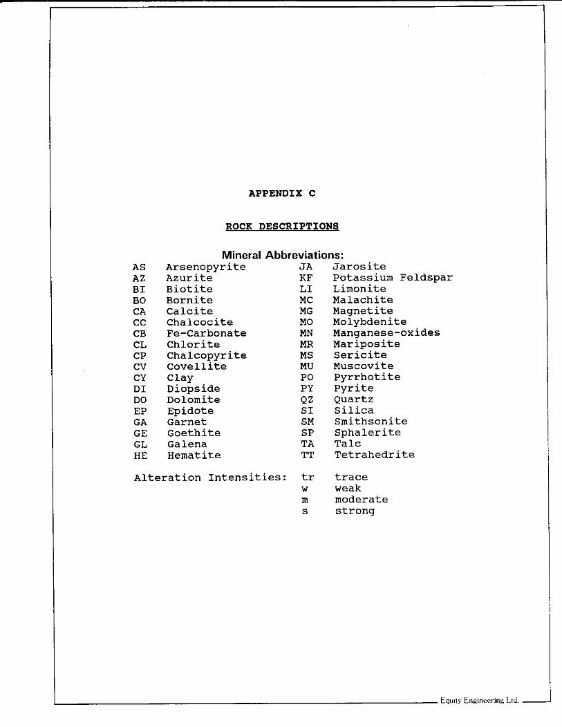
APPENDIX C
ROCK DESCRIPTIONS
Mineral Abbreviations: Arsenopyrite Azurite Biotite Bornite Calcite Chalcocite Fe-Carbonate Chlorite Chalcopyrite covellite Clay Diopside Dolomite Epidote Garnet Goethite Galena Hematite
JA KF LI MC MG MO MN m MS MU PO PY Qz SI SM SP TA TT
Alteration Intensities: tr W m s
Jarosite Potassium Feldspar Limonite Malachite Magnetite Molybdenite Manganese-oxides Mariposite Sericite Muscovite Pyrrhotite Pyrite Quartz Silica Smithsonite Sphalerite Talc Tetrahedrite
trace weak moderate strong

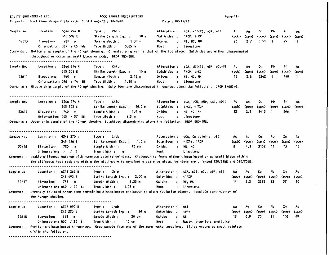
EQUITY ENGINEERING LTD. ROCK SAMPLE DESCRIPTIONS
Property : Scud River Pro ject ( T u i l i g h t Grid Area)NTS : 104G14E Date : 09111191 Page-1
Sample No. Location : 6346 368 N Type : Float A l te ra t i on : UNALTERED Au Ag Cu Pb 2n AS
345 956 E S t r i k e Length Exp. : - - - m Sulphides : NONE OBSERVED ~ppb) (ppn) (ppn) (Ppn) (Ppn) (ppn) 52501 Elevation: 980 m Sample Width : ... m Oxides : NONE OBSERVED 9 1 . 9 30 14 27 1
: Limestone o r ien ta t i on : - - I - - True Width : m Host ..- C m n t s : From s o i l p i t a t s o i l sample s t a t i o n CL960, 3+25. S o i l sample uas anomalous in Pb and 2n.
......................................................... Sample No. Location : 6346 180 N Type : Select A l te ra t i on : NONE OBSERVED Au Ag Cu Pb 2n As
345 850 E S t r i k e Length Exp. : 0.5 m Sulphides : 4 X C P . 8OWY (ppb) (ppn) (ppn) (ppn) (ppn) (ppn) 52502 Elevation: 975 m Sample Width : 10 cm Oxides : MC, L I 56 7 . 9 4501 1 313 1
Orientat ion: 140 I 44 SW True Width : 40 cm Host : Limestone
Comnents : Massive p y r i t e pod measuring 0.4m*0.5m, contains t races of chalcopyrite. from rock sample 52556 a t appproximately 0+75S, 1+OOW on the Tu i l i gh t gr id .
Rock sample taken one metre uest along s t r i k e ALDER SHOWING.
Sample No. Location : 6346 226 N Type : Grab A l t e r a t i o n : wSI Au Ag Cu Pb 2n As
52503 Elevation: 905 m Sample Width : 10 cm Oxides : HE 7 3.1 132 28 35 50 345 758 E S t r i k e Length Exp. : 10 m Sulphides : NONE OBSERVED (ppb) (ppn) (ppn) (Ppn) Cnm) (ppn)
Or ientat ion: ? I ? True Width : 2.0 m Host : Brecciated limestone
C m n t s : Highly f ractured and s l i g h t l y s i l i c i f i e d massive limestone u i t h hematite s ta in ing along the fractures.
breecia?
Probable f a u l t
Sample taken a t approximately 2+00W, 0+35S on the Tu i l i gh t gr id . ____________________~~ . . . . . . . ~~ .~~ . .~~~~~~~ . . . .~~~~ .~ . .~~ Sample No. Location : 6346 180 N Type : Chip A l t e r a t i o n : TA. CY A" Ag Cu Pb 2n As
52504 Elevation: 975 m Sample Width : 1 . 6 m Oxides : GE, MC. MN 21 4.5 955 732 2196 27 345 850 E S t r i k e Length Exp. : 2 . 7 m Sulphides : <lXPY, 4 X S P . t r C P , t r G L (ppb) (ppn) (ppn) (ppn) (ppn) (ppn)
or ientat ion: 184 I 3 0 W True Width : 1.8 m Host : Talc sch is t and c a l c - s i l i c a t e schist.
C m n t s : Chip sample across B mineral ized shear zone exposed i n trench TR-91-01. on the T u i l i g h t gr id .
Trench located a t approximately l+OOW, 0+75S ALDER SHOWING.
Sample No. Location : 6346 180 N Type : Select A l t e r a t i o n : TA Au Ag Cu Pb 2n AS
345 850 E S t r i k e Length Exp. : 0 . 5 m Sulphides : 307$Y, 20-25%SP, t r G L (ppb) (ppn) (ppn) (W) (ppn) (ppn) 52505 Elevation: 975 m Sanple Width : 10 cm Oxides : GE 64 17.2 1993 4007 124500 131
Orientat ion: 184 I 30 W True Width : 5 cm Host : Calcareous t a l c sch is t .
C m n t s : Select sample of a 3 t o 5 cm. uide sulphide band i n the t a l c schist. TR-91-01. ALDER SHOVING.
Sulphide band exposed i n the upper pa r t of trench
Sample No. Location : 6346 180 N T y p e : Chip A l t e r a t i o n : T A Au Ag Cu Pb 2n As 345 850 E S t r i k e Length Exp. : ,20 m Sulphides : <lXPY, 5XSP. t r G L (ppb) (ppn) (ppn) (Ppn) (ppn) (ppn)
52506 Elevation: 975 m Sanple Width : 1.4 m Oxides : GE, MN 53 8.4 1557 1231 23035 66 Orientat ion: 117 I 24 S True width : 1.4 m Host : Calcareous t a l c sch is t .
C m n t s : Chip sample across a t a l c sch is t unit conta in ing several 1 t o 3 cm. uide sulphide bands uhich are or iented p a r a l l e l t o f o l i a t i o n . ALDER SHOWING.
.........................................................

EQUITY ENGINEERING LTD. ROCK SAMPLE DESCRIPTIONS
Property : Scud River Project ( T u i l i g h t Gr id Area)NTS : 104G/4E Date : 09/11/91 Page-2-
Sample NO. Location : 6345 800 N T y p e : Grab A l te ra t i on : CB Au A9 Cu Pb Zn As
52507 Elevation: 680 m Sample Uidth : 10 cm Oxides : NONE OBSERVED 8 1.1 34 16 80 89 345 185 E S t r i k e Length Exp. : 1.0 m Sulphides : NONE OBSERVED (ppb) (W) (rn) (W) (W) (ppn)
Orientat ion: 040 I 65 S True Uidth : 30 cm Host : Mottled. grey limestone.
Comnents : I r o n carbonate a l t e r a t i o n zone containing s m vuggy c a l c i t e ve in le ts , exposed along Cu t creek.
Sample NO. Location : 6345 775 N Type : Grab
345 205 E S t r i k e Length Exp. : 3.0 m
52508 Elevation: 690 m Sample Uidth : 10 cm Orientat ion: 030 I 90 True Uidth : 20 cm
Rusty horizon u i t h i n a black a r g i l l i t e exposed along Cut creek. Comments :
......................................................... Sample No. Location : 6345 770 N Type : Grab
345 235 E S t r i k e Length Exp. : 5.0 m
52509 Elevation: 700 m Sample Uidth : 10 cm
Orientat ion: 009 I 79 U True Uidth : .2.0 m
C m e n t s : Rusty ueathering sch is t outcropping along Cut creek.
ALteration : UNALTERED Au Ag cu Pb Zn As
Oxides : GE 5 1.0 69 10 110 48 Host : Black a r g i l l i t e .
Sulphides : t r P Y (ppb) (W) (W) ( P P ) (W) (W)
Al te ra t i on : Ms, 02 Au Ag Cu Pb Zn As
Oxides : GE 2 0.1 32 44 104 12 Host : Ser i c i t e (?) sch is t .
Sulphides : *1xpI (ppb) (W) (ppn) (ppnl (WI (ppn)
Sample NO. Location : 6345 700 N Type : Select
345 290 E S t r i k e Length Exp. : 10.0 m
52510 Elevation: 765 m Sample Uidth : 5 cm Orientat ion: 190 I 4 0 U True Uidth : 5 cm
Al te ra t i on : UNALTERED
Sutphides : 1-2XPY Oxides : HE
Host : Limestone.
Comnents : Hematite s ta in ing uhere p y r i t e ve in i s exposed on the east s ide of Cut creek. the limestone uhich may ind i ca te normal movement along the f a u l t .
Vein located be l l ou a large 2 - f o l d w i t h i n
......................................................... Sarrple No. Location : 6346 292 N Type : Float A l te ra t i on : TA AU Ag cu Pb Zn As
m Oxides : GE 14 0.6 195 1 1 85 19 345 748 E S t r i k e Length Exp. : - - - m Sulphides : NONE OBSERVED (ppb) (W) (ppn) (Ppn) (W) (am)
52511 Elevation: 885 m Sample Uidth : .._ Orientat ion: - - I - - True Uidth : - - - m Host : Limestone and t a l c schist.
C m n t s : Rock fragments from s o i l p i t from uhich anomalous s o i l sample CLZMO, 1+25 uas taken.
top of the hole but no bedrock i s exposed w i t h i n the hole.
Rusty fragments located near the
Sample No. Location : 6346 272 N Type : Grab A l te ra t i on : UNALTERED Au Ag Cu Pb 2n As
52512 Elevation: 885 m Sample Uidth : 10 cm Oxides : NONE OBSERVED 2 2.6 17 19 11 48 345 742 E S t r i k e Length Exp. : 4 . 0 m Sulphides : NONE OBSERVED (ppb) (W) (W) (ppn) (W) (W)
Orientat ion: ? I ? True Uidth : 2.0 m Host : Grey marble.
C m n t s : Rock face above anomalous s o i l p i t a t CL860, 1+00.

EQUITY ENGINEERING LTD. ROCK SAMPLE DESCRIPTIONS
Property : Scud River Project ( T u i l i g h t Grid Area)NTS : 104G14E Date : 09111191 Page-3.
sample No. Location : 6346 402 N Type : Float A l t e r a t i o n : UNALTERED AU Ag
345 7’76 E S t r i k e Length Exp. : - - - m Sulphides : t r P r (ppb) ( P P ) 52513 Elevation: 885 m Sample Uidth : ... m Oxides : NONE OBSERVED 9 1 . 8
Orientat ion: - - I - - True Uidth : - - - m nost : Granite C m e n t s : Gran i t i c pebbles frm s o i l p i t i n which anomalous s o i l sample CL860, 2+75 uas taken.
are thought t o have been transported frm a d i s tan t source.
Pebbles are well rounded and therefore
Sample No. Location : 6346 420 N Type : Float A l te ra t i on : UNALTERED AU Ag
345 814 E S t r i k e Length Exp. : - - - m Sulphides : NONE OBSERVED (ppb) (ppn) 52514 Elevation: 890 m Sample Uidth : ... m Oxides : NONE OBSERVED 6 2.5
Orientat ion: - - I - - True Uidth : - - - m Host : Mott led greyish u h i t e Limestone. Comnents : Rock fragments from s a i l p i t where anomalous s o i l sample CL860, 3+00 was taken. Marble outcrop located nearby.
Sample No. Location : 6346 480 N Type : Grab A l t e r a t i o n : UNALTERED AU A9
345 864 E S t r i k e Length Exp. : 10.0 m Sulphides : NONE OBSERVE0 (ppb) (ppn) 52515 Elevation: 860 m Sample Uidth : 10 cm Oxides : NONE OBSERVED 2 2 .6
Orientat ion: ? I ? True Uidth : 2 . 0 m nost : Grey marble. Comments : Massive marble outcrop above anomalous s o i l sample p i t a t l oca t i on CL860, 3+75.
Sample NO. Location : 6346 492 N Type : Float A l te ra t i on : UNALTERED AU Ag
345 882 E S t r i k e Length Exp. : - - - m Sulphides : NONE OBSERVED (ppb) (ppn) m Oxides : GE 4 2 . 6 52516 Elevation: 895 n Sample Uidth : ...
Orientat ion: - - I - - True Uidth : - - - m Host : Greyish uhite, mot t led marble. C m e n t s : Rock fragments from s o i l p i t where anomalous s o i l sample CL860, 4+00 was taken.
uhich may be a possible f a u l t ? Found along a gu l l ey trending 024 degrees
......................................................... sample No. Location : 6346 506 N Type : Grab A l t e r a t i o n : UNALTERED AU Ag
345 905 E S t r i k e Length Exp. : 1.0 m Sulphides : NONE OBSERVED (ppb) (ppn) 52517 Elevation: 890 m Sample Uidth : 10 cm Oxides : NONE OBSERVED 1 2.3
Orientat ion: 180 I 8 4 E True Uidth : 50 cm most : Marble. C m e n t s : Graphit ic, sheared marble located two metres douns lop from the Location of a n m l o u s s o i l sample CL860. 4+25. Possible
f a u l t zone?
sample No. Location : 6346 518 N Type : Float A l te ra t i on : US? AU Ag
345 920 E S t r i k e Length Exp. : - - - m Sulphides : NONE OBSERVED (ppb) (ppn) 52518 Elevation: 895 m Sample Uidth : ... n Oxides : GE 49 0.1
Orientat ion: - - I - - True Uidth : - - - m Host : Schist? C m e n t s : Rusty, schistose fragments from anunalous s o i l sample l oca t i on CL860, 4+50.
degrees uhich may be a f a u l t zone. S o i l p i t located i n a gu l l ey trending 050
Pb
(W) 5
Pb
(ppn) 15
Pb
15
Pb
( P P ) 33
Pb
(W) 15
Pb
(ppn) 20

EOUITY ENGINEERING LTD. ROCK SAMPLE DESCRIPTIONS
Property : scud River Project ( T u i l i g h t Grid Area)NTS : 104G/4E Date : 09/11/91 Page-4-
Sample No. Location : 6346 550 N Type : Float A l te ra t i on : wCB Au Ag CU Pb Zn AS
in Oxides : L I 7 2.5 9 14 146 10 345 970 E S t r i k e Length Exp. : - - - m Sulphides : NONE OBSERVE0 (ppb) (ppn) (ppn) (ppn) (ppn) (W)
52519 Elevation: 905 m Sample Uidth : ...
m Host : Lirnestone. Orientat ion: - - I - - True Uidth : - - - C m e n t s : Ueakly carbonate a l te red white limestone f l o a t u i t h minor l i m o n i t i c s ta in ing found on a ta lus s l o w located above a n m l o u s
s o i l sample CL860, 5+25.
Sample No. Location : 6346 386 N Type : Float A l t e r a t i o n : Unaltered 345 964 E S t r i k e Length Exp. : - - - m Sulphides : t r P Y
m oxides : GE 52520 Elevation: 980 m Sample Uidth : ... Orientat ion: - - I - - True Uidth : - - - m Host : Limestone
C m e n t s : Rock chips from s o i l p i t a CL960, 3t75. Sample l i e s i n a d r y gu l ly , trending 11 degrees.
Sample No. Location : 6346 468 N Type : Float A l t e r a t i o n : Unaltered 346 008 E S t r i k e Length Exp. : - - - m Sulphides : None observed
52521 Elevation: 980 m Sample Uidth : .-. m Oxides : Hone v i s i b l e Or ientat ion: - - I - - True Uidth : - - - m Host : Chertllirnestone
C m e n t s : From s o i l p i t a CL960, 4+75. Sample l i e s in a drainage g u l l y trending 46 degrees (possible f a u l t zone).
Sample No. Location : 6346 490 N Type : Float A l te ra t i on : Unaltered 346 018 E S t r i k e Length Exp. : - - - m Sulphides : None observed
m Oxides : None v i s i b l e 52522 Elevation: 965 m Sample Uidth : ... Orientat ion: - - / - - True Uidth : - - - m Host : Breccia
Comnents : Limestone and cher t fragments i n a f a u l t breccia w i th carbonate cement. Sample taken a t CL960, 5t00.
Sample No. Location : 6346 510 N Type : Float 346 028 E S t r i k e Length Exp. : -.- m
m 52523 Elevation: 955 m Sample Uidth : ...
or ien ta t i on : - - / - - True Uidth : - - - m
C m n t s : F r m s o i l p i t CI CL960, 5+25. I n a d r y g u l l y t rending 46 degrees
......................................................... Sample No. Location : 6346 528 N Type : Float
346 032 E S t r i k e Length Exp. : - - - m m ... 52524 Elevation: 950 m Sample Uidth :
Orientat ion: -~ I - - True Uidth : - - - m
C m n t s : From s o i l p i t a t CL960, 5+50.
A l t e r a t i o n : Unaltered Sulphides : None observed Oxides : None v i s i b l e Host : Chert
A l t e r a t i o n : Unaltered Sulphides : None observed Oxides : None v i s i b l e Host : Limestone + cher t

EQUITY ENGINEERING LTO. ROCK SAMPLE DESCRIPTIONS
Property : Scud River Project (Tw i l i gh t Grid Area)NTS : 104G/4E Date : 09/11/91
Sample No. Location : 6345 455 N Type : Select A l te ra t i on : Unknoun
52525 Elevation: 990 m Sample Yidth : 10 cm Oxides : L I 345 655 E S t r i k e Length Exp. : 10 m Sulphides : 1-3WY
Orientat ion: 060 / 52 SE True Yidth : 3 m Host : Black a r g i l l i t e Ccmnents : Rusty shear zone w i t h p y r i t e along f ractures and cleavage planes. Taken near the headuaters of Cut Creek
Page-5-
Sample No. Location : 6345 570 N Type : Float A l t e r a t i o n : CA, AK
345 475 E S t r i k e Length Exp. : - - - m Sulphides : None observed 52526 Elevation: 920 m Sample Yidth : 10 cm Oxides : None v i s i b l e
Orientat ion: -. / - - True Width : 10 cm Host : Calc i te-anker i te ve in Comnents : Vuggy v e i n mater ia l exposed on the bank of Cut Creek. Source i s probably nearby.
......................................................... Sample No. Location : 6347 785 N Type : Grab A l te ra t i on : SI, 0 2 . AK Au Ag CU Pb Zn As
346 380 E S t r i k e Length Exp. : 1 m Sulphides : None observed (ppb) (ppn) (ppn) (ppn) (ppn) (ppn) 52527 Elevation: 520 m Sample Yidth : 10 cm Oxides : None v i s i b l e 3 1 . 7 8 1 20 1
Orientat ion: 124 / 15 SW True Uidth : 3-10 cm Host : Si l iceous s i l t s t o n e and limestone Coments : ouartz-ankerite vein. Crosscuts bedding i n h i g h l y deformed sediments. Taken on the bank of a small stream approx imte l y
100 metres south of 10+00 S on the Contact Creek g r id .
Sample No. Location : 6347 800 N Type : Grab A l te ra t i on : S I , QZ. CA AU Ag Cu Pb Zn As
346 335 E S t r i k e Length Exp. : 0.5 m Sulphides : None observed (ppb) (ppn) (ppn) (PW) (ppn) (ppn) 52520 Elevation: 520 m Sample Uidth : 30 cm Oxides : L I 2 2.3 8 1 31 1
Orientat ion: 127 / 10 SU True Width : 1 cm Host : Si l iceous si l tstone+limestane
C m e n t s : Cmposite of several p a r a l l e l qua r t z -ca l c i t e ve in le ts , crosscut t ing sediments. sample 52527. Veins f o l l o u the a x i a l planar cleavage of a small fo ld .
Taken approximately 10 m t r e s NE o f
......................................................... sample No. Location : 6347 725 N Type : Float A l te ra t i on : Unaltered Au Ag Cu Pb Zn As
52529 Elevation: 535 m Sample Uidth : ... m Oxides : L I 1 0.4 7 7 16 20 346 350 E S t r i k e Length Exp. : - - - m Sulphides : t r P Y (ppb) (ppn) (ppn) (Ppn) (ppn) (ppn)
Orientat ion: -. / - - True Yidth : - - - m nost : Blue-grey chert C m n t s : Rusty ueathering cher t f l o a t . The source i s probably nearby.
Sample No. Location : 6346 194 N Type : Float A l te ra t i on : UNALTERED Au Ag Cu Pb 2n As
345 840 E s t r i k e Length Exp. : - - - m Sulphides : t r P Y (ppb) (ppn) (m) (ppn) (ppn) (ppn) 52551 Elevation: 965 m Sample Yidth : .-. m Oxides : JA 12 2 .9 130 36 797 1
Orientat ion: - - / - - True Yidth : - - - m Host : Dark grey, sheared limestone Comnents : Sample taken fran s o i l p i t a t s o i l sample s t a t i o n CL960. 0+50.

EQUITY ENGINEERING LTO. ROCK SAMPLE DESCRIPTIONS
Property : Scud River Project (Tw i l i gh t Gr id Area)NTS : 104G/4E Date : 09/11/91 Page-6-
sample No. Location : 6346 180 N Type : Grab A l te ra t i on : TA Au Ag Cu Pb Zn AS
52552 Elevation: 975 m Sample Yidth : 10 cm Oxides : GE, MC 97 15.4 4375 2419 10202 35 345 850 E S t r i k e Length Exp. : 1.0 m Sulphides : IXCP, 1%PY, 2%SP (ppb) (ppn) (ppn) (ppn) (ppn) (ppn)
Orientat ion: 085 I 4 1 S True Yidth : 60 cm Host : Sheared limestone Conrnents : Mineral ized zone 0.5 t o 1 m t h i ck . Overlain by limestone and under la in by weathered shale. ALDER SHWING.
sample No. Location : 6346 180 N Type : Chip A l te ra t i on : TA, PZ veining AU Ag C u Pb Zn As
52553 Elevation: 975 m Sample Uidth : 1.0 m Oxides : JA, MC 43 10.1 2239 3700 5511 40 345 850 E s t r i k e Length Exp. : 1.2 m Sulphides : ~l%CP,1-2%PY.~l%GL,~l%SP (ppb) (ppn) (ppn) (ppn) (ppn) (ppn)
Orientat ion: 085 / 41 S True Yidth : ? m Host : L i m y t a l c sch is t Ccmnents : Zone o f sheared rock composed of l i m o n i t i c gouge and in tense ly f ractured a r g i l l i t e . Zone i s over la in by curv i -p lanar
t a l c sch is t . The whole package i s speculated t o be a shear zone. ALDER S H W I N G .
Sample No. Location : 6346 160 N Type : Select A l te ra t i on : EP Au Ag Cu Pb 2n As
52554 Elevation: 1020 m Sample Yidth : 10 cm Oxides : AZ. MC 104 13.0 15568 74 398 39 345 944 E S t r i k e Length Exp. : 3 m Sulphides : t r C C , SXCP, t r P Y (ppb) (Plan) (P) (ppn) (ppn) (ppn)
Orientat ion: 163 I 8 2 SU True Yidth : 10 cm Host : Limestone C m e n t s : Limestone outcrop cut by a 2 metre wide zone o f p a r a l l e l 10-15 cm wide quartz veins. Only one ve in i s mineralized.
Taken a t O+OO Y, 1+00 S on the Twi l ight grid. ......................................................... sample No. Location : 6346 076 N Type : Grab A l te ra t i on : MS Au Ag C u Pb Zn AS
52555 Elevation: 1055 m Sample Uidth : 30 cm Oxides : L I 2 2.2 182 41 108 26 345 860 E S t r i k e Length Exp. : 10-15 m Sulphides : < l % P Y (ppb) (ppn) (ppn) (ppn) (ppn) (ppn)
Orientat ion: 150 / C8 U True Width : 30 cm Host : Limestone Conrnents : Mineral ized uaLlrock t o a s e r i c i t i c f a u l t zone c u t t i n g limestone. Taken a t 1+00 U. 1+75 S on the Twi l ight grid.
......................................................... Sample No. Location : 6346 180 N Type : Grab A l te ra t i on : CY Au Ag Cu Pb Zn AS
52556 Elevation: 975 m Sample Width : 0.5 m Oxides : AZ. GE, JA, MC 152 19.5 11545 76 7040 52 345 850 E S t r i k e Length Exp. : 2.5 m Sulphides : l-S%CP, 5-15XPY (ppb) (W) (ppn) (ppn) (ppn) (ppn)
Orientat ion: 065 I 4 1 S True Uidth : 0.5 m Host : Limestone C o m n t s : Quartz-carbanate ve in ing associated w i th shearing. Taken a t 1+00 Y, 0+75 S on the Twi l ight grid. Part of the ALDER
S H W I N G .
sample NO. Location : 6346 180 N Type : Chip A l te ra t i on : TA, Dl7 Au Ag Cu Pb 2n As
345 850 E S t r i k e Length Exp. : 1.8 m Sulphides : t r C P , <1WY (ppb) (ppn) (ppn) (ppn) (ppn) (ppn) 52557 Elevation: 975 m Sample Yidth : 1.6 m Oxides : HE, MN 16 2.7 461 178 345 6
Orientat ion: 062 / 31 S True Yidth : 1.6 m Host : Ca lc -s i l i ca te schis t C m n t s : Chip across trench TR-91-02 of the ALDER SHOVING.

EQUITY ENGINEERING LTD. ROCK SAMPLE DESCRIPTIONS
Property : Scud River Pro ject (Twi l ight Gr id Area)NTS : 104G/4E Date : 09/11/91
Sample No. Location : 6346 180 N Type : Grab A l t e r a t i o n : TA, D I
52558 Elevation: 975 m Sample Width : 30 cm Oxides : HE 345 850 E S t r i k e Length Exp. : 1.8 m Sulphides : 1XPY
Orientat ion: 062 I 31 S True Width : 50 cm Host : t a l c - s i l i c a t e schis t
C m e n t s : Euhedral p y r i t e along f o l i a t i o n planes. ALDER SHOWING.
Page-7-
AU Ag Cu Pb Zn As
13 2.6 369 69 311 11 (ppb) (ppn) (ppn) (ppn) (ppn) (ppn)
Sample No. Location : 6346 180 N Type : Grab A l t e r a t i o n : TA, 01 AU Ag Cu Pb 2n As
345 850 E S t r i k e Length Exp. : 5 m Sulphides : 4 X C P . trGL, 5ZPY. 4%SP (ppb) (ppn) (w) (ppn) (ppn) tm) 52559 Elevation: 975 m Sample Width : 15 cm Oxides : None v i s i b l e 83 8.9 2256 813 19107 94
Orientat ion: 074 I 4 1 S True Width : 5-10 cm Host : Talc sch is t shear zone
Comments : s t r a t i f o r m minera l izat ion i n wavy t a l c sch is t . Sample taken 1.5 metres above trench TR-91-02, ALDER SHOVING.
Sample No. Location : 6346 180 N Type : ch ip A l t e r a t i o n : CA. TA AU Ag Cu Pb 2n As
52560 Elevation: 975 rn Sample U id th : 1.5 m Oxides : None v i s i b l e 18 4.5 1135 467 2472 45 345 850 E S t r i k e Length Exp. : >3 m Sulphides : tr-2XPY (ppb) (ppn) (ppn) (ppn) (ppn)
Orientat ion: 074 I 4 1 S True width : 1.5 m Host : Talc sch is t
Comments : Chip across mineral ized zone in t a l c sch i s t . The zone contains 3 2 t o 10 cm wide mineral ized horizons. ALDER SHOVING.
Sample No. Location : 6346 180 N Type : Grab A l t e r a t i o n : 02, CB AU Ag Cu Pb 2n As
52561 Elevation: 975 m Sample Width : 30 cm Oxides : MC 3 3.6 829 54 889 43 345 850 E S t r i k e Length Exp. : 1 m Sulphides : lXPY (ppb) (W) (ppn) (ppn) (ppn) tppn)
Orientat ion: 134 I 54 S True Width : 30 cm Host : Quartz-carbonate ve in
Comments : Abundant quartz veining. ALDER SHOWING.
sample No. Location : 6346 130 N Type : Grab A l t e r a t i o n : sns Au Ag Cu Pb 2n AS
52562 Elevation: 1035 m Sample Width : 40 cm Oxides : Unaltered 21 0.7 I 8 9 15 21 345 920 E S t r i k e Length Exp. : 2 m Sulphides : l X P Y (ppb) (ppn) (ppn) cw, (ppn) (rn)
Orientat ion: 164 I 4 5 W True Width : 0.5-1 m Host : t a l c - s e r i c i t e sch is t
comnents : Thin hor izon of f i n e sulphides, re la ted t o shearing. Located a t approximately 0+30 W , 1+25 S on the Twi l ight gr id .
Sample No. Location : 6345 535 N Type : Grab A l t e r a t i o n : sMS, sQ2 Au Ag Cu Pb 2n As
52563 Elevation: 1005 rn Sample Width : 1.5 rn Oxides : L I 1 0.1 35 19 72 14 345 655 E S t r i k e Length Exp. : 2 m Sulphides : 4 X P Y (W) (ppn) (ppn) Cnn) (ppn) tppn)
Orientat ion: 185 I 5 5 W True Width : 1.5 m Host : Puar t z -py r i t e -se r i c i t e sch is t
C m e n t s : Al tered shear zone hosted i n limestone. Truncated by l i m e s t a n e l a r g i l l i t e f a u l t contact.

EQUITY ENGINEERING LTD. ROCK SAMPLE DESCRIPTIONS
Property : Scud River Pro ject (Tw i l i gh t Gr id AreaINTS : 104t/4E Date : 09/11/91 Page-8.
sample No. Location : 6345 595 N T y p : Grab A l t e r a t i o n : CB, Us, Q2 Au Ag Cu Pb 2n As
52564 Elevation: 840 m Sample Width : 0.5 m Oxides : L I 4 0.2 35 23 113 33 345 385 E S t r i k e Length Exp. : 5 m Sulphides : 1-2WY (ppb) (ppn) (ppn) (ppn) (ppn) (ppn)
Orientat ion: 208 I 4 0 U True Uidth : 1-2 m Host : Sericite-quartz-carbonate-pyrite schis t Comnents : Exposed i n C u t Creek.
......................................................... Sample No. Location : 6345 460 N Type : Grab A l t e r a t i o n : Unknoun Au Ag Cu Pb 2n As
52565 Elevation: 935 m Sample Width : 15 cm Oxides : HE, JA 15 0.9 29 11 64 14 345 525 E S t r i k e Length Exp. : 25 m Sulphides : 1-2WY (ppb) (ppn) (ppn) (ppn) (ppn) (ppn)
Orientat ion: 000 / 82 E True Uidth : 15 cm HOS t : Rusty-weathering a r g i L l i t e
Comnents : One of many p y r i t i c horizons i n r u s t y a r g i l l i t e . P y r i t e i s s t r a t i f o r m and f rac tu re contro l led.
Sample NO. Location : 6346 208 N Type : Float
345 868 E S t r i k e Length Exp. : - - - m m 52566 Elevation: 970 m Sample Width : _ _ _
m Orientat ion: - - / - - True Uidth : ...
C o m n t s : Taken a t CL960, 0175.
A l t e r a t i o n : Unaltered? Au Ag CU Pb 2n AS
Sulphides : t r P Y (ppb) tppn) (ppn) ( P P ) (ppn) (ppn) Oxides : Mc 27 2.7 115 1 21 1 Host : Massive, mott led limestone
Sample No. Location : 6346 224 N Type : Float
345 890 E S t r i k e Length Exp. : - - - m m ..- 52567 Elevation: 975 m sample Width :
m Orientat ion: - - I - - True Uidth : ...
C m e n t s : Fractured b u l l quartz taken a t CL960, 1 t O D .
A l t e r a t i o n : Q2 Au Ag Cu Pb Zn AS
Oxides : None v i s i b l e 5 1.7 37 11 67 13 Host : Quartz ve in
Sulphides : None observed (ppb) (ppn) (ppn) (ppn) mil) (ppn)
sample No. Location : 6346 236 N Type : Float
345 912 E S t r i k e Length Exp. : - - - m m 52568 Elevation: 975 m Sample Uidth : .-.
m ... Orientat ion: - - / - - True Uidth : C o m n t s : Subrounded fragments. Taken a t CL960, 1+25.
......................................................... Sample NO. Location : 6346 252 N T y p e : Float
345 932 E S t r i k e Length Exp. : - - - m m .-. 52569 Elevation: 960 m Sample width :
R ..- Orientat ion: - - I - - True Uidth :
Comnents : Taken a t CL960, l+50.
A l t e r a t i o n : CB Au Ag CU Pb 2n AS
Sulphides : t r C P , t r P Y ( w b ) (ppn) (ppn) (ppn) (ppn) (ppn) Oxides : JA 22 2.0 688 14 103 38 Host : Recrystal l ized, f o l i a t e d limestone
A l t e r a t i o n : C B A u Ag Cu Pb 2n As
Oxides : HE 4 2.5 28 20 33 45 Host : Sheared, my lon i t i c l inestone
Sulphides : None observed (ppb) (ppn) (ppn) (ppn) (ppn) (ppn)

EQUITY ENGINEERING LTD. ROCK SAMPLE DESCRIPTIONS
Property : Scud River Pro ject (Tw i l i gh t Gr id Area)NTS : 104G14E Date : 09111191 Page-9-
Sample No. Location : 6346 320 N Type : Grab A l te ra t i on : sCA, sol(?) AU Ag Cu Pb 2n As
52601 Elevation: 775 m Sample Uidth : 1.00 m Oxides : 1WC. HE 2 1.8 4074 20 255 21 345 565 E S t r i k e Length Exp. : 25 m Sulphides : t r C P (ppb) (ppn) (ppn) ( P P ) (ppn) (ppn)
Orientat ion: 130 / 35 SU True Uidth : 0.15 m Host : Limestone u i t h chert interbeds C m n t s : Malachite stained pods scat tered throughout a shear zone. D i s t i n c t f o l i a t i o n u i t h i n the zone s t r i k e s 060 degrees and
d ips 42 degrees t o the south but i s h igh l y convoluted in places. Actual u i d t h of the shear zone i s approximately one metre. ......................................................... Sample No. Location : 6346 330 N Type : Select A l t e r a t i o n : sCA, sol(?) AU Ag Cu Pb 2n AS
345 570 E S t r i k e Length Exp. : 0.15 m Sulphides : 1 X P (ppb) (ppn) (ppn) (ppn) (ppn) (ppn) 52602 Elevation: 775 m Sample Uidth : 15 cm Oxides : GE, HE, MC 23 6.2 12636 18 167 1
Orientat ion: 130 / 50 SU True Uidth : 15 cm Host : Limestone u i t h chert interbeds. C m e n t s : Pod of copper-r ich sulphides w i t h i n the shear zone.
the fractures.
Pods occur sporadica l ly throughout the f a u l t and are found along Rock sample taken 15 metres along s t r i k e from rock sample 52601.
Sample No. Location : 6346 274 N Type : Grab A l te ra t i on : sCA, m t o sDI0) AU Ag Cu Pb 2n As
345 548 E S t r i k e Length Exp. : 40 m Sulphides : t r C P (ppb) (ppn) (ppn) (Ppn) Cppn) (ppn) 52603 Elevation: 780 m Sample Uidth : 1.00 m Oxides : HE, MC, MN 3 3.0 1870 1 719 1
Orientat ion: 040 I 8 5 SE True Uidth : 0.15 m Host : Limestone. Coments : Fol ia ted shear zone. Malachite s ta in ing occurs u i t h hematite along f rac tu re surfaces. F o l i a t i o n i s convoluted i n places.
Fault zone i s approximately 0.7 metres uide.
Sample No. Location : 6346 274 N Type : Grab A l t e r a t i o n : sCA, m T A 0 ) . YEP, 01(?) Au Ag Cu Pb 2n As
52604 Elevation: 740 m Sanple Uidth : 1.2 m Oxides : HE, 19W 18 3.1 4708 13 76 17 345 502 E S t r i k e Length Exp. : 10 m Sulphides : l%CP ( w b ) (ppn) (ppn) (PP) (!TI) (ppn)
: Limestone Or ientat ion: 050 I 8 5 SE True Uidth : 0.8 m Host Coments : Shear zone approximately 4 metres wide. Uel l f o l i a t e d but f o l i a t i o n has been folded i n places. Chalcopyrite occurs
f i n e l y disseminated along f o l i a t i o n planes or as small blebs i n c a l c i t e veins. Same shear as samples 52601.2. DROP SHOWING.
Sample No. Location : 6346 330 N Type : Grab A l te ra t i on : wCA, 02 veining, 0 1 0 ) AU A9 Cu Pb 2n As
52605 Elevation: 680 m Sample Uidth : 0.4 m Oxides : MC 8 2.2 1074 11 49 17 345 446 E S t r i k e Length Exp. : 1.5 m Sulphides : 4 X C P (Wb) (ppn) (ppn) (Ppn) (rn) (ppn)
or ien ta t i on : 005 I 4 5 E True Uidth : 0.3 m Host : Limestone C m n t s : Centimetre scale quartz ve in le t s containing chalcopyrite, found w i t h i n an one metre wide shear zone. The shear zone
i s exposed w i t h i n a small stream. ......................................................... Sample No. Location : 6346 506 N Type : Float A l te ra t i on : sSI AU Ag Cu Pb 2n As
345 450 E S t r i k e Length Exp. : - - - m Sulphides : t r P Y (ppb) (ppn) (ppn) (ppn) (ppn) (ppn) 52606 Elevation: 650 m Sanple U id th : ... m Oxides : GE, JA 3 1.0 175 6 28 1
Orientat ion: - - I -. True Uidth : - - - m Host : Unknown C-nts : Angular f l o a t measuring 15cm*tOcm*5cm, f o d a t approxiametly 5*00U, 2+3ON on the Twi l ight grid. Vein has a porous
texture uhere the s u l f i d e s have been leached out. .........................................................

EQUITY ENGINEERING LTD. ROCK SAMPLE DESCRIPTIONS
Property : Scud River Project (Tw i l i gh t Gr id Area)NTS : 104G/4E Date : 09/11/91 Page-10-
sample No. Location : 6346 180 N Type : Chip A l te ra t i on : sCA. sTA, us1 Au Ag Cu Pb Zn As
52607 Elevation: 975 n Sample Uidth : 1.10 m Oxides : GE, HE, MN 7 3.5 1075 54 591 17 345 850 E S t r i k e Length Exp. : 1.30 m Sulphides : <l%CP, TXPY (ppb) (ppn) (ppn) (ppn) (ppn) (rn)
Orientat ion: 054 I 34 SE True Uidth : 1.03 m Host : Calcareous t a l c sch is t C o m n t s : Chip sample frm the b o t t m of trench TR91-03.
chalcopyr i te i s found w i t h i n c a l c i t e f i l l e d fractures.
P y r i t e occurs as f i n e l y disseminated cubes throughout the sch is t whi le
ALDER SHOUING. ......................................................... Sample No. Location : 6346 180 N Type : Grab A l t e r a t i o n : sSI Au Ag Cu Pb Zn AS
52608 Elevation: 975 m Sample Uidth : 15 cm Oxides : GE, HE, MN 65 3 . 3 398 179 909 97 345 850 E S t r i k e Length Exp. : 0.15 m Sulphides : 4XPI (ppb) (rn) (ppn) (ppn) ~ r n ) (ppn)
Orientat ion: 164 I 4 7 E True Uidth : 15 cm Host : Calcareous t a l c sch i s t
Comments : Limoni t ic Layer w i t h i n sch is t . Pinches out t o the west. Has a strong baxuork texture and oxides make up more than
20% of the Layer. Found i n trench TR91-03. ALDER SHOUING.
Sample No. Location : 6346 180 N Type : Chip A l t e r a t i o n : sCA. us1 AU Ag Cu Pb Zn As
52609 Elevation: 975 n Sample Uidth : 30 cm oxides : HN 17 2.1 384 93 1786 44 345 850 E S t r i k e Length Exp. : 0.4 m Sulphides : 3YzY (ppb) (ppn) (ppn) (rn) (rn) (ppn)
Orientat ion: 054 I 3 4 SE True Uidth : 25 cm Host : Calcareous t a l c sch is t .
S i l iceous and p y r i t i c zone surrounding Limonit ic pod i n trench TR91-03. occurs as s t r ingers. ALDER SHOUING.
C m e n t s : P y r i t e i s e i t he r disseminated throughout o r
......................................................... Sample No. Location : 6346 180 N Type : Chip A l te ra t i on : sCA, sTA. us1 Au Ag Cu Pb Zn As
52610 Elevation: 975 m Sample Uidth : 1.15 m Oxides : GE, HE, MN 2 2.1 296 296 598 1 1 345 850 E S t r i k e Length Exp. : 1.40 m Sulphides : 2XPY (ppb) (ppn) (ppn) (rn) (ppn) (W)
Orientat ion: 065 I 57 SE True Uidth : 1.00 m Host : Calcareous t a l c ( ? ) sch is t
C m e n t s : Upper p a r t of the calcareous sch is t in trench TR91-03. P y r i t e i s disseminated throughout. ALDER SHOUING.
......................................................... Sample No. Location : 6346 180 N Type : Chip A l t e r a t i o n : sCY, m S I , wCA A u Ag Cu Pb Zn As
52611 Elevation: 975 m Sample Uidth : 30 cm Oxides : NONE OBSERVED 3 3 . 7 646 1505 1328 15 345 850 E S t r i k e Length Exp. : 1.6 m Sulphides : t rPY, t r S P , t r G L (ppb) (ppn) (ppn) (rn) (ppn) (ppn)
Orientat ion: 090 I 3 0 S True Uidth : 20 cm Host : Calcareous ta l c (? ) sch i s t and limestone.
C m e n t s : Faul t gouge zone between the l imestone and the calcareous sch is t a t the top of trench TR91-03. ALDER SHOUING.
Sample No. Location : 6346 532 N Type : Grab A l t e r a t i o n : CA veining Au Ag Cu Pb Zn As
345 352 E S t r i k e Length Exp. : 5.0 m Sulphides : 2%PY (ppb) (ppn) (ppn) (ppn) (ppn) (ppn) 52612 Elevation: 565 m Sarrple Uidth : 30 cm Oxides : GE, HE 2 1.0 3% 8 48 9
Orientat ion: 094 I 9 0 True Uidth : 20 cm Host : Rusty and calcareous a r g i l l i t e .
C m n t s : Stockwork of CA ve in ing w i t h i n an a rg i l l eous host. Argi l laceous unit contains boulders of a r g i t l i c limestone. P y r i t e Ca lc i t e ve in le t s range in s i z e frm 4 cm t o 5 cn. occurs as blebs i n the veins or as s t r i nge rs w i t h i n the a r g i l l i t e .
.........................................................
EQUITY ENGINEERING LTD. ROCK SAMPLE DESCRIPTIONS
Property : Scud River Pro ject (Tw i l i gh t Grid Area)NTS : 104G/4E Date : 09/11/91 Page-11-
Sample No. Location : 6346 274 N Type : Chip A l t e r a t i o n : sCA, ~010). m€P, uSI AU Ag Cu Pb 2n As
345 502 E S t r i k e Length Exp. : 10 m Sulphides : 1XCP. t r C C (W) (W) (W) (W) (W) (ppn) 52613 Elevation: 740 m Sample Uidth : 1.30 m Oxides : HE, MC, MN 26 2 . 7 5051 1 9 9 1
Orientat ion: 039 I 85 NU True Uidth : 0.85 m Host : Limestone
C m e n t s : Bot tan ch ip sample of the ‘Drop‘ shouing. Or ien ta t i on given i s that o f the f o l i a t i o n . Sulphides are e i the r disseminated
throughout o r occur as small blebs o r pods. DROP SHOVING. ......................................................... Sample No. Location : 6346 274 N Type : Chip A l t e r a t i o n : sCA, ~ 0 1 0 ) . rrEP, uCL+SI Au Ag Cu Pb 2n As
345 502 E S t r i k e Length Exp. : 10 m Sulphides : lXCP, t r C C (ppb) (W) (W) (W) (W) (ppn) 52614 Elevation: 740 m sample U id th : 2.15 m Oxides : HE, MC, MN 18 2 .8 3242 1 140 1
or ientat ion: 026 I 74 SE True Width : 1.80 m Host : Limestone
C o m n t s : Middle ch ip sample o f the ‘Drop‘ shouing. Sulphides are disseminated throughout along the f o l i a t i o n . DROP SHMIINC.
Sample No. Location : 6346 274 N Type : Chip A l t e r a t i o n : sCA, sCB, mEP, u S I , nOl? AU Ag Cu Pb 2n As
345 502 E S t r i k e Length Exp. : 10.0 m Sulphides : t r C C , <l%CP (ppb) (W) (rn) (ppo) (W) (P) 52615 Elevation: 740 m Sample U id th : 1.9 m Oxides : HE, MC, MN 23 2 .5 2413 1 6 6 6 1
Orientat ion: 045 I 57 SE True Width : 1.5 m Host : Limestone
C o m n t s : Upper ch ip sample of the ‘Drop’ shouing. Sulphides disseminated along the f o l i a t i o n . DROP SHOWING.
......................................................... Sample No. Location : 6346 270 N Type : Grab A l t e r a t i o n : sCA, CA veining, u S I Au Ag Cu Pb Zn As
345 486 E S t r i k e Length Exp. : 1 . 0 m Sulphides : <l%$’Y. lXCP (ppb) (W) (W) (W) (Plan) (ppn) 52616 Elevation: 730 m sample Width : 70 cm Oxides : HE, MC 8 4 . 2 3152 1 1 73 18
Orientat ion: ? I ? True Width : m Host : Limestone
C o m n t s : Weakty s i l i ceous outcrop u i t h numerous c a l c i t e ve in le ts .
the s i l i ceous host rock and u i t h i n the m i l l i m e t r e t o centimetre scale ve in le ts . Veinlets are oriented 120I82NE a r d 02017DSE.
Chalcopyrite found e i the r disseminated o r as small blebs u i t h i n
......................................................... sample No. Location : 6346 268 N Type : Chip A l t e r a t i o n : sCA, sCB, wCL, YEP, uSI Au Ag Cu Pb Zn AS
52617 Elevation: 735 m Sample Uidth : 1.35 m Oxides : HE, MC 14 2 . 3 2225 13 37 10 345 492 E S t r i k e Length Exp. : 2.00 m Sulphides : 4 X C P (ppb) (W) (W) (W) (W) (W)
Orientat ion: 049 I 4 0 SE True Width : 1.25 m Host : Limestone C m n t s : s t rong ly f o l i e t e d shear zone containing disseminated chalcopyr i te along f o l i a t i o n planes. Possible cont inuat ion o f
the ‘Orap‘ shouing. ......................................................... Sample NO. Location : 6347 090 N T y p e : Grab A l t e r a t i o n : Y S I AU Ag Cu Pb 2n AS
52618 Elevation: 385 m Sample Uidth : 20 cm Oxides : GE 19 0 . 9 70 21 106 49 344 330 E S t r i k e Length Exp. : 20 m Sulphides : trPY (ppb) (rn) (rn) (P) (ppa) (Fpn)
Orientat ion: 000 I 3 0 E True Uidth : 10 cm Host : Rusty, g raph i t i c a r g i l l i t e
Carmnts : Pyr i te i s disseminated throughout. Grab sample fran one of the mare rusty locations. S i l i c a occurs as small ve in le t s
u i t h i n the f o l i a t i o n . .........................................................

EQUITY ENGINEERING LTD. ROCK SAMPLE O E S C R l P T l O N S
Property : Scud River Project ( T u i l i g h t Gr id Area)NTS : 104G/4E Date : 09/11/91
Page-12.
Sample No. Location : 6346 336 N Type : FLOat A l te ra t i on : CA veinlets, uCB & SI AU Ag Cu Pb 2n As
345 446 E S t r i k e Length Exp. : - - - m Sulphides : 5XPI. l X C P (@) (ppn) (ppn) (ppn) (ppn) (ppn) 52619 Elevation: 680 m Sample Uidth : .-. m Oxides : t r H E & MC 635 19.9 5411 1923 2794 184
Orientat ion: - - / - - True Yidth : - - - m Host : Limestone.
C m e n t s : Gossanous f l o a t u i t h i n a creek gu l l ey a t approxiamtely 5+00U. 0+58N.
........................................................

APPENDIX D
TRENCH MAPS


Clnit 2,
U n i t 3
M . o n

-0-I(.

APPENDIX E
CUMULATIVE FREOUENCY DISTRIBUTIONS
FOR SOIL GEOCHEMISTRY
Equity Engineering Ltd.


-.- * , .. -
P I I
75
.- C
RESOURCES LTD.
I
K-7 (1, UUC) P p l CONSOLIDATED GOLDWEST I

* D
*
P
a
yl
I
1
I I
CUMULATIVE ~ E R C E N T .a- L T , -
a 9 r ul O S R 4 : $ s E g q q 4 4 i d l


APPENDIX F
CERTIFICATES OF ANALYSIS

cmp: PROJ: A I T N :
EOUIlY ENGINEERING LTD. $rim PIVFP
MIN-EN LABS - I C P REPORT 705 VEST l 5 1 H S T . . NORTH VANCCUVER. B.C. V7M 112
FILE NO: 15-0238-R DATE: 91/08/
SAMPLE NUMBER 52501 52502 52503 52504 52505 52506 52551 52552 52553 52554 52555 52556 52557 52558 52559 52560 52561 52601 52602 52603 52604 52605 52606 52607 52608 52609 52610 5261 1

JJ \ , 'vmr'w' 705 WEST 15TH STREET NORTH VANCOUVER, B.C. CANADA V7M 172 TELEPHONE 18041 880-5814 OR (8041 988-4524 FAX 16041 980-9621
TELEPHONE 1807) 622-8958 FAX 18071 623-5931
TELEPHONEIFAX (604) 647-3004
EN THUNDER BAY LAB.:
SMITHERS LAB.:
LABORATORIES iDlViSION OF ASSAYERS COW 1
SPECIALISTS IN MINERAL ENVIRONMENTS i,iFU,TI.. . i r ; A Y i i i s . AN*L"+1' i . GE.n7,E,..! ' '~'<
D a t e : AUG-01-93 i n p , 1 . PFi iYE E Q U I T I E S INC., VANCOUVER, B.C.
Ue hereby certify t h e f o l l o w i n g Assay of 7 ROCK samples submitted JUL-26-91 by ROBERT FALLS.
Sampl. e i' LI IN rkmbE: ..
1 . 4 :~ L-CICC-? .,-.-, 1 *:
-.

COMP: EOulIY
.- SAMPLE NUMBER S*OOU 1+75N 5+00U 1+50N 5+0W 1+00N 4+0W 4+00N 4+OOU 3+75N 4+OOU 3+00N 4tOW 0+75N &+OW 2'75s &+OW 3+00S 4+00u 3+255 4+0W 3 t50S 4+OOu 4 t25S 4+00U 4t5OS 4+oou 4+755 4+00u 5+00s 3+00u 1+75N 3+00U 160N 3*00U 1+25N 3+00U l+OON 3+00u 0+75N 3*00u 015011 3 + 0 W 0+25N 3+00u 0*25S 3+00u 0+50S 3*00u 0+75S 3+00u l t 0OS 3+00U 1+25S 3+00U 1+50s 3 + 0 W 1+75s 3+00U 2+00s 3+00u 2+25s 3+00u 2150s 3+00U 2+75S 3+OOU 3+00S 3+00U 3+25S 3+00u 3 t50S 3+00u 3+755 3 + 0 W 4+00S 3iOOU 4 t25S 3+00u 4+50s 3+0W 1+75s 3+00U 5+00S 2+00U 3+50N 2+00U 3 i25N 2+00u 3+00N 2tOW 2+75N 2tOOU 2+50N 2+00U Zt25N 2+00U 2+00N 2+00U 1+75N 2+00u 1+50N 2+0OU i+oos 2+OOU 2+00s 2tOOU 2125s 2+00U 2+50S 1+OW 1+50N l+OOU 0+50s 1+oou 0+75s l+OOU 3+00S l+OOU L+2%
~__.___
~~
ENGlNl PROJ: SCUD RIVER A I I N : HENRY ALMAC
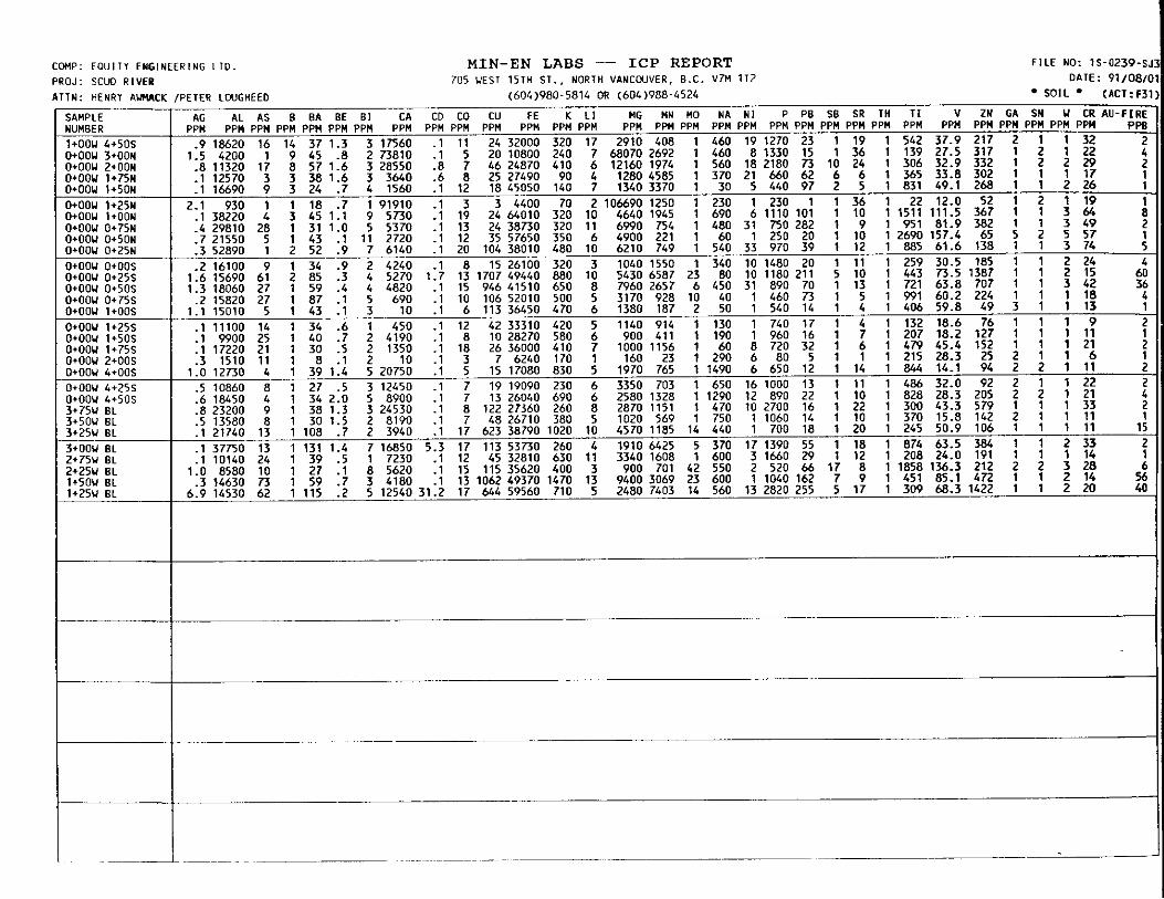
COMP: E O U I I Y ENGINEERING L T D . MIN-EN LABS - I C P REPORT PROJ: ATTN:
SCUD RIVER HENRY A W C K
SAMPLE (UMBER I+OOU 4+50S l+OOU 3+00N l+OOU 2+00N l+OOU 1+75N J+OOu 1+50N POOU 1+25N l+OOU l+OON l+OOU O t 7 5 N l*OOU 0+50N POOU O t 2 5 N ItOOU O+OOS ItOOU O t 2 5 S l+OOU 0+50S l+OOu O t 7 5 S l+OOU 1+oos l+OOU 1+25S l + O O U 1+50S l+OOU 1+75S l+OOU 2+00s JtOOU 4+00S l+OOu 4+2% l+OOU 6+50S 3 + 7 5 u B L 3+50U BL 3*25U BL 3tOOU B L 2+75U B L
lt50U BL 2 + 2 5 u BL
1 + 2 5 u BL
7115 UFST l 5 T H S T . . NORTH VANCOUVER. B.C. V M 112
~
SR 1 PPM P I 19 36 24 6 5
36 10 9
10 12 11 10 13 5 4 4 7 6 1
14 11 10 22 10 20 18 12 8 9
17
~
__
__
__
__
~
F ILE NO: 1s-0239-s D A I E : 911081
SOIL (ACT:F3


cmp: PROJ: A T T N :
E0UlT.I ENGl SCUD R I V E R HI AIMACK/ J
SAMPLE NUMBER CL 6 6 0 2 6 0 s
CL 6 6 0 3+005 CL 6+50 3+255 CL 6+50 3+50s CL 6+50 3+755 CL 6+50 4+00S CL 6+50 4+25S CL 6+50 4+50s CL 6+50 4,755 CL 6*50 5+00S CL 6+5O 5+25s CL 6+50 5 6 0 s CL 6+50 5+?5s C L 6+50 6rOOS CL 6+50 6+25s CL 6+50 6+50s CL 6+50 e 7 5 5 CL 6+50 7+MK 6+00U 4+00N
6+0W 3+50N 6+0W 3+2SN 6rOOU 3t00N
6+00U 2+50N 6+00U 2+25N
6+00u 1+5m 6+00u 1+25Y 6+00U l+OON 6+00U O+EN 6+00U O+5ON 6+00U 0125N 6+00u 0+25s 6+00u 0+50s 6+00U 0+75s 6+00u 1+OOs 6+00U 1+25s 6+00U 1+5Os 6+00U 1 + E S 6+00U 2+00s
CL 6+50 2+75s
6+00U 3*BN
6+00U 2+75N
6+00U 2+00N 6+00U 1+75N

COWP: EOUITY ENGRG./PRIME E Q U I T I E S PROJ: SCUD R I V E R P .O. KGGPL ATTN: H.AUIIACKIJ.FOSTER
MIN-EN LABS - I C P REPORT 7 0 5 WEST 15TH ST., NORTH VANCOUVER, B.C. VM 1 1 2
( 6 0 4 ) 9 8 0 - 5 8 1 4 OR ( 6 0 4 ) 9 8 8 - 4 5 2 4
F I L E NO: l S - 0 2 8 5 - S J 1 DATE: 9 1 1 0 8 1 1
S I L T S * (ACT:F31
SAMPLE UUMBER
P l R F - 0 1 P l R F - 0 2 P l R F - 0 3 P l R F - 0 4 P l R F - 0 5

COHP: EQUITY ENGRG./PRIME E Q U I T I E S PROJ: SCUO RIVER P.O. KGGPL ATTN: H.A(MACKIJ.FOSTER
MIN-EN LABS - ICP REPORT 705 UEST 15TH ST., NORTH VANCWVER, B . C . V M 112
(604)980-5814 OR (604)988-4524
F I L E NO: lS-0285-RJl DATE: 91/081
ROCK * (ACT:F3
SAMPLE NUMBER 52507 52508 52509 52510 52511 52512 52513 52514 52515 52516 52517 52518 52519 52520 52521 52522 52523 52524 52525 52526 52527 52528 52529 52562 52563 52564 52565 52566 52567 52568 52569 52612 52613 52614 52615 52616 52617 52618

F I L E NO: lS-0285-RJ3. DATE: 91/08/'
* ROCK (ACT:F3'
SAMPLE NUMBER 8115 8116 8117 81 18 8119 8120 8121 8122 8123 8124 8125 8126 8127 8128 8129 8130 8131 8132 8133 8134 8135 8136 8137 8138 8139 8140 8141 8142 8143 8144 8145 8146 8147 8148 8149 8150 8151 8152 8153 8154 8155 8156 8157 8158 8159 8160 8161 8162 8163 8164 8165 8166 8167 8168
-_.

CDHP: EQUITY ENGINEERING LTD. PROJ: SCUD RIVER,P.O.KGGPL
MIN-EN LABS - ICP REPORT 705 WEST 15TH S T . , NORTH VANCWVER, B.C. V7n 112
F I L E NO: 1S-0361-R o m : 9 i i o 8 i
ATTN: J.FOS1
$AMPLE WHBER 52619
I H.ALMACK (604)980-5814 OR (604)988-4524 . A G AL AS B BA BE B I CA CD CO CU FE K L I MG MN MO WA NI P PB S B SR T H TI V 2N GA SN U CR AU-FIRE
PPW PPW PPW PPH PPW PPW PPW PPU PPW PPH PPW PPW PPW PPW PPW PPW PPW PPM PPW PPW PPW PPW PpIl PPW PPM PPW PPW PPW PPM PPW Ppll PPB 19.9 1190 184 19 6 .1 1 72740 22.6 12 5411 81300 1490 17 17040 4542 11 10 1 590 1923 14 176 1 36 41.9 2794 1 1 3 38 635

[CUP: EOUlIY ENGINEERING LTD. PROJ: SCUD R I V E R P.O. KGGPL;H IN~EN A I I N : H.AIMACK/J.FOSTER
- SAHPLE NUMBER 5+00u 4+00N 5+00U 3+75N 5+OOU 3+50N 5+00U 3+25N 5+OOu 3t00N 5+00U 2+75N 5+00u 2 + 5 0 ~
_____
5+00U 2*25N 5+00U 2tODN 5+00u l t 2 5 ~ 5+00u Ot75N
5+DOU 0+25N 5+DOu 0+25s 5+OOu Ot50S 5+oou 0+75s 5+00u l t O O S 5+DOU 1+25s 5+00u 2100s 4+00U 3+50N 4100U 3+25N 4+00u 2 t 7 5 ~ 4+DOU 2+50N 4+00U 2t2SN 4+00U 2IOON 4+00U 1+75N
-___.
5+00U O+SON
-
______
4+00U 1+OON 4+00u 0+50N 4+0W 0+25N 4+00U 0125s 4+00u 0150s 4+00U 0+75S 4+00U 1+OOS 4+00u 1+25s 4+00u l t50S 4+00u Zt50S L+OOU 3+7% 4+00U 4+OOs 3+00U 4+0DN 3+00U 3+75N 3+00U 3+50N 3+00U 3+25N 3+00U 3+00N 3+00U 2+75N 3r00U 2+50N 3+00U 2+25N 3+00U 2+00N 2+00U 4+00N 2+00U 3+75N 2+00U 1+25N Z+ODU l+OON 2+00U 0+75N 2+00U 0+50N 2+00U 0+25N 2+00U 0+25s 2+DOU 0+50s 2+00u 0+75s 2+DOU 1+25s ~ - _ _ _
AG AL AS
.3 6010 36
.3 5710 6
.1 13520 13
.1 22680 1
.2 13340 8
.1 6850 179
.2 9830 36
.2 13190 41 1.1 2450 5 1.0 15980 36
.1 10950 119 5.9 18080 180
.1 11280 18
.4 7220 28
.5 4000 34
.4 1530 11 3.2 1090 6 .4 3900 10 .8 5460 35
4.4 11030 35 3.2 20970 22 2.6 14670 42 2.3 13630 23 .4 2430 3 .4 1950 1 .5 3880 34
7.6 11110 17 .4 16650 17
1.3 10570 39 12< 1.2 14100 22 3.9 28680 1
.3 540 3
PPU PPM PPM PI
-
~i 4700 R 2:s 6860 8 1.3 14310 84 2.2 6820 16
.6 7500 36
.1 3070 3
.P 6870 10 14 8580 1 .a 16160 a .1 5450 44
1.8 11630 14 3.9 14570 67
20.9 21550 109 1.3 9390 12
.1 13210 47
.4 6130 44 2.3 22520 15
.9 19660 10 3.0 23000 52
.3 29200 1 1.5 17920 16
.7 20330 13
.2 16220 1
.2 25830 29
.7 15140 45 1.7 9890 62
.2 10730 13
.1 5080 15
MIN-EN LABS - ICP REPORT 705 WEST l51H ST.. NORTH VI\NCCUVER. 8.C. V M 112
FILE NO: lS-0362-SJ1+2 DATE: 91/08/11

COHP: EOUITY ENGINEERING LTO. PROJ: SCUD R I V E R P.O. KGGPL;HIN-EN A T I N : H.AIMACK/J.FC
SAMPLE
2+00u 1+50S 2tOOU 1+75s
2+00U 3+00S 2+00U 3+25S 2tOOW 3+505 2+00w 3+75s 2+0OW 4+005 2+00W 4+255 2rOOw 4+50S l+OOU 3+75N 1+OOw 3+50N l + O O W 3+25U l+OOU 3+00N
1+OOw 2+50N l + O O W 2+25N 1+OOW 2100N 1+OOu 1*75N 1+OOu 1+25N
1+OOw 0+75N 1+OOu 0150N 1+OOw 0+25N 1+OOw O t 2 5 S 1+oow l + O O S l+OOW 1+255 l t O O W 1+50S l+OOU 1+75s l+OOU 2t00S 1+OOu 2+25S l+OOw 2+50S l+OOU 2+75S l+OOw 3+25S 1+OOw 3+50S l+OOW 3+75s l t O O W 4+00s l+OOU 4+75s 1+OOW 5*00S O+OOW 4*00N O+OOU 3+EN
S R
2+00w 2 + n s
I+OOU 2 t n u -
l + O O W l + O O N
O+OOY 3+50N O+OOu 3+25N
O+OOu 2+25N O+OOu 2+255 O+OOu 2+505 o+oou 2+75s WOOU 3+005 O+OOw 3+255 O+OOU 3+755 O+OOU 4*75s O+OOU 5+00S EL 8+OW
8L 7+5w EL 7+25U EL 6-75U
O+OOU 2+75N O+OOU 2+50N
BL 7+75u
IR
AG AL AS PPM PPM PPM PI
.1 4410 9
.1 24530 11
.3 10910 9
.1 15270 15
.2 4500 7
.4 13680 4
.5 20930 6
.4 18400 1
.6 19500 8
.4 9970 7 1.0 16630 3
.5 29060 16 2.5 29180 33 2.1 40340 4 1.1 19410 26
.3 40320 1
.1 8420 6
.1 23580 1
.2 5930 25
.2 33950 12
.3 27400 19 4.1 16390 23
.6 20480 24 1.3 20810 56 .9 14830 24 .7 8770 28 .1 6380 17 .1 10620 22 .1 22940 14 .1 23050 9 .2 14870 7 .5 7870 8 .4 15750 4
1.3 7270 1 .6 11470 5 .2 M O 5 .4 8170 4 .5 13930 14
2.8 4670 1 1.2 20790 5 1.4 22380 21 1.1 20060 6 2.1 4120 1 2.1 4080 1 2.0 4600 1
.4 26610 13
.1 27050 20
.3 25110 4
.1 31900 12
.5 10220 13
.3 21120 10 1.1 9420 9 .9 3110 3
1.6 1120 32 1.9 1050 36 1.5 1080 33 .9 1860 26 .9 930 19
8.1 24710
MIN-EN LABS - I C P REPORT 705 WEST 151H ST. . NORTH V A N C I V E R , E.C. V7M 112
1 m m 0 - 5 8 1 4 OR 1604)988-4524
FILE NO: 15-0362-5J3+1 DATE: 91108l l i
* SOIL (ACT:F31'
NA N I P PB ! PPM PPM PPM PPW PI 160 4 710 11 90 1 470 25 50 15 1550 15 70 13 650 14 70 27 960 11
,400 4 640 25 1620 16 1700 43 180 14 1140 15
1380 27 1370 36 I220 13 1080 25 1500 19 1960 56 I210 11 1520 200 980 26 2050 516 990 1 880 156 130 15 900 137
1310 1 1460 38 810 1 320 35 760 1 780 92
1420 2 380 27 1010 55 3570 492 1350 20 670 42 140 18 1560 60
!040 17 2910 108 130 27 460 57
1070 9 830 53 750 16 1010 38 700 15 1410 20
1180 1 1670 22 980 3 630 18 170 24 480 26 40 1 380 39
1160 1 500 42 1450 1 480 41 850 1 500 38
1160 1 470 27 130 17 1310 24
1640 5 1120 26 790 7 1180 21 20 36 670 43
1080 23 880 80 1510 1 790 62 960 37 2980 82
1510 6 1060 36 6450 6 1540 65 1380 1 600 17 1000 8 1280 61 1090 25 810 29 1100 38 560 64
60 7 520 23 100 15 690 57 90 31 1350 40
900 23 580 42 1230 9 1220 27 1180 4 370 37 920 19 950 29 910 16 780 32 640 21 830 23 910 28 1600 29 $90 15 1030 19
- SR
8 17 21 23 15 13 18 15 19 12 21 14 19 9
17 9 4 9 8
41 10 17 21 21 13 15 14 25 10 10 7 6 6 9 6
18 9 9
13 59 11 24 16 37 33 28 11 13 11 16 18 11 21 6
106 126 105 48 39
-
-
-
-
-
-
-
-
-
-
-

COHP: EQUIIY ENGlNEERlNG L I D . PROJ: SCUD RIVER P .O. KGGPL;MIN-EN ATTN: H.AIMACK/J.FOSTER
MIN-EN LAB8 - I C P REPORT 7 0 5 WEST l 5 T H ST., NORTH VANCOUVER, B.C. V M 1 1 2
( 6 0 4 ) 9 8 0 - 5 8 1 4 OR ( 6 0 4 ) 9 8 8 - 4 5 2 4
SAMPLE
BL 6+25W BL 6 + 0 0 U EL 5+75U
EL 5+00W BL BL 4+50u
BL 4+00u BL 2+50u BL 2+00u BL 1+75u BL 1+oou
BL 0+50W BL 0 + 2 5 U
I
FILE NO: 1s-03C DATE: 911
SOIL (AC1

APPENDIX G
STATEMENTS OF OUALIFICATIONS

I, ROBERT B. FALLS, of 103-2181 Panorama Drive, North Vancouver, in the Province of British Columbia, DO HEREBY CERTIFY:
1. THAT I am a Consulting Geologist with offices at Suite 207, 675 West Hastings Street, Vancouver, British Columbia.
2 . THAT I am a graduate of the University of Toronto with a Bachelor of Science degree in Geology, 1982.
THAT my primary employment since 1987 has been in the field of mineral exploration.
THAT this report is based on fieldwork carried out under my direction, and on assessment reports filed with the province of British Columbia.
3 .
4 .
5. THAT I have no interest in the property described herein, nor in securities of any company associated with the property, nor do I expect to acquire any such interest.
/ R w ?--kh Robert Falls, Geologist