Embed Size (px)
Citation preview

Sites
LEJ Boundary
• Emory Grove Historic District‘Decatur vicinity, DeKaib County, GeorgiaSketch MapNational Register Boundary —
• Contributing Property CIINoncontributing Property ~Scale: 1”=350’ North: t
Contributing
Noncontributing
~L..
RPJLROAO
—I —
1
24 DECATUR

NPSFOnTI1O-900 - OMBN0.1024-0018United States Department of the InteriorNational Park Service Ci’ocoo 3cc
NATIONAL REGISTER OF HISTORIC PLACES REGISTRATION FORM
This form is for use in nominating or requesting determinations of eligibility for individual properties or districts. See instructions in Guidelines for CompletingNational Register Forms” (National Register Bulletin 16). Complete each item by marking “X” in the appropriate box or by entering the requested information.If an item does not apply to the property being documented, enter “N/A’ br ‘not applicable.” For functions, styles, materials, and areas of significance, enteronly the categories and subcategories listed in the instructions. For additional space use continuation sheets (Form 1O-900a). Type all entries.
1. Name of Property
historic name Emory Grove Historic Districtother nameslsite number N/A
2. Location
street & number Centered on North Decatur Road between the CSX railroad line and theUniversity Park-Emory Highlands-Emory Estates Historic District.
city, town Decatur (x) vicinity ofcounty DekaIb code 089state Georgia code GA zip code 30307
( ) not for publication
3. Classification
Ownership of Property: Category of Property:
(x) private ( ) building(s)public-local (x) districtpublic-state ( ) sitepublic-federal ( ) structure
object
Number of Resources within Property: Contributing Noncontributing
buildings 200 13sites 4 0structures 1 0objects 0 0total 205 13
Contributing resources previously listed in the National Register: N/AName of previous listing: N/AName of related multiple property listing: N/A

4. State/Federal Agency Certification
As the designated authority under the National Historic Preservation Act of 1966. as amended. hereby certifythat this nomination meets the documentation standards for registering properties in the National Register ofHistoric Places and meets the procedural and professional requirements set forth in 36 CFR Part 60. In myopinion, the property meets the National Register criteria. ()See continuation sheet.
Signature of certifying official Date
W. Ray LuceDirector, Historic Preservation Division,Georgia Department of Natural Resources
In my opinion, the property ( ) meets ( ) does not meet the National Register criteria. ()See continuation sheet.
Signature of commenting or other official Date
State or Federal agency or bureau
5. National Park Service Certification
I, hereby, certify that this property is:
()entered in the National Register
_____________________________________ _____________
() determined eligible for the National Register
_______________________________________ ______________
()determined not eligible for the National Register
_____________________________________ _____________
()removed from the National Register
_____________________________________ _____________
Qother, explain:
_______________________________________ ______________
()see continuation sheet
_____________________________________ _____________
Keeper of the National Register Date
Emory Grove Historic District, DeKaib county, Georgia 2
6. Function or Use
Historic Functions:
Domestic: single dwellingEducation: schoolReligion: religious facility, church school
Current Functions:
Domestic: single dwellingEducation: schoolReligion: religious facility, church school
7. Description
Architectural Classification:
Late 19th and 20th Century Revivals: Colonial Revival, Late Gothic Revival
Materials:
foundation Concretewalls Brickroof Asphaltother Wood: weatherboard
Description of present and historic physical appearance:
The Emory Grove Historic District is an approximately 90-acre residential neighborhood locatedbetween Emory University and the city of Decatur. The neighborhood is organized as a series ofloop roads that branch from North Decatur Road. Princeton Way, developed in 1939, loops south ofNorth Decatur Road; Westminster Way and Edinburgh Terrace, located north of North DecaturRoad, were developed in 1941. In the center of each loop road is a landscaped recreational parkwhich is accessed by narrow paths between houses.
The neighborhood of Emory Grove is bounded on the north and east by the CSX railroad line. Thesouth and southwest boundary is denoted by the rear lots of homes along Princeton Way. Theextreme westernmost edge is the Druid Hills High School property line and the University Park-Emory Highlands-Emory Estates Historic District. The small-scale houses are built on small lots onslightly hilly terrain (photos 4 and 21-22). The subdivision is harmonious in appearance with uniformsetbacks and Colonial Revival-style houses (photos 4-9). The roads are curvilinear with landscapedtraffic islands at the major intersections (photos 5, 7, 11, and 23-24).
The houses were constructed in one basic residential style with several variations. This type is aone-story, or one-and-one-half-story, rectangular-shaped house with a moderate pitched, sidegabled roof, interior, central chimney, and smaller side-gabled wings (photo 6 and 19). Variations
Emory Grove Historic District, DeKaib County, Georgia 3

NPS Form 10-900-a 0MB Approved Na 1024-0018
United States Department of the InteriorNational Park SerMce
National Register of Historic PlacesContinuation Sheet
Section 7--Description
include front-gabled porches, dormer windows, slightly projecting front-gabled wings, and variouschimney placements. Decorative trim and moldings are flat and not highly detailed. Screenedporches are customarily located on the main facade. The houses are not high style but represent aminimalistic variation of traditional Colonial Revival-style design. Some houses feature gambrelroofs with broad, overhanging eaves in the Dutch Colonial Revival style (photo 22).
The material used for building Emory Grove houses was for the most part brick veneer, clapboardsiding, or masonry. In many cases the brick walls are laid in Flemish bond. The roofs were originallycovered with large asbestos shingles. Today, most roofs have been replaced with smaller-scaleasphalt shingles. Windows throughout the historic district are both wood sash and steel casementwindows. Some of the homes’ screened porches have been enclosed with glass, usually in keepingwith the modest style of the house, to provide additional living space.
The houses are sited with uniform setbacks, facing the winding curbed streets of Westminster Way,Edinburgh Terrace, Princeton Way, and North Decatur Road. The placement of these homesafforded the creation of three interior parks accessed by a series of narrow, mostly unpaved pathscalled by-ways. These by-ways are located between residential lots. Emory Grove Park, in thenortheast corner of the historic district, is the most elaborate with recreational equipment, pavedwalks, picnic pavilion, and historic landscaping (photos 30- 31). Westminster Way Park is a broad,open field with tennis courts (photo 29), and Princeton Way Park features a baseball field (photo 28).Ball fields, playgrounds, tennis courts and picnic tables are available for neighborhood use in theseparks. Various fencing types delineate the rear yards of the private properties from these commongrounds. Braided wire fencing and mature shrubs and tree lines can often be found at the rear of theproperties facing the interior parks. Other types of fencing can also be seen here, including chain-link and wood-plank fences.
Sidewalks exist only on North Decatur Road. Landscaped triangular-shaped traffic islands mark themajor intersections. Because the subdivision was built during the rise of the automobile, drivewaysand garages are common to most Emory Grove houses. Some houses built after World War II donot have garages, possibly because of building supply shortages during the war.
The landscape is cultivated with mature plantings, evidence of the continuous care of homeownersfor over fifty years. Dogwood, red oak, magnolia, and maple trees abound in the small front yards.Along Princeton Way retaining walls have been constructed to control the sloping topography.Nandina and hollies edge the rear lot borders. Pines tower over the houses but no trees line thestreets because there are no sidewalk strips like those in the adjacent University Park-EmoryHighlands-Emory Estates Historic District.
Emory Grave Historic District, DekaIb county, Georgia 4
NPS Form 10-900-a 0MB Approved No. 10240018
Unfted States Department of the InteriorNational Park Service
National Register of Historic PlacesContinuation Sheet
Section 7--Description
Emory Grove includes two substantial community landmark buildings, Druid Hills High School andEmory Presbyterian Church. Both resources are located at the intersection of Haygood Drive andNorth Decatur Road in the northwest corner of the historic district. Druid Hills High School, built in1928, was designed in the Colonial Revival style by the Atlanta architectural firm Ivey and Crook(photo 1). The two-story school features a five-part Palladian plan with a central pavilionsurmounted by a multi-stage cupola. The side wings include many of the elements of the main block,including Flemish-bond brickwork, quoihs, and ornate entrances framed in cast concrete. Thesymmetry of the main facade is reminiscent of Georgian Revival-style buildings.
Atlanta architects Sayward and Logan designed the Emory Presbyterian Church in 1946 (photo 2).Completed two years later, the Gothic Revival-style church is sheathed in granite with a centrallancet window outlined with stone tracery. The Gothic-style main entrance is located on the side ofthe main building, opening to Westminster Way and the Emory Grove neighborhood. A largegrassed lawn extends from the building to North Decatur Road. Mature trees surround the building.
The Emory Grove neighborhood has changed very little since its 1948 period of significance ended.The landscape has matured and some of the houses have been altered but in mostly non-obtrusiveadaptations creating an architecturally consistent urban subdivision in central DeKaIb County.
Emory Grove Historic District, DeKaIb County, Georgia 5

8. Statement of Significance
Certifying official has considered the significance of this property in relation to otherproperties:
nationally ( ) statewide (x) locally
Applicable National Register Criteria:
(x)A ( )B (x)C ( )D
Criteria Considerations (Exceptions): (x) NIA
)A ( )B ( )C ( )D ( )E ( )F ( )G
Areas of Significance (enter categories from instructions):
ArchitectureLandscape ArchitectureCommunity Planning and Development
Period of Significance:
1928-1948.
Significant Dates:
1928 - Druid Hills High School built.1939- Neal Smith develops Princeton Way.1941 - Neal Smith develops Westminster Way and Edinburgh Terrace.1948 - Emory Presbyterian Church is completed.
Significant Person(s):
N/A
Cultural Affiliation:
N/A
Architect(s)IBuilder(s):
lvey and Crook, architect.Robert and Company, engineer.Sayward and Logan, architect.
Emory Grove Histo~ic District, DeKaib county, Georgia 6
NPS Form 10-900-a 0MB Appro’~ed No. 1024-0018
Unft~ States Department of the InteriorNational Park Service
National Register of Historic PlacesContinuation Sheet
Section 8--Statement of Significance
Narrative statement of significance (areas of significance)
The Emory Grove Historic District is a small, intact historic residential area that developed insuburban DeKaIb County beginning with the construction of Druid Hills High School in 1928 andending with the completion of Emory Presbyterian Church in 1948. Most of the houses in the historicdistrict were constructed between 1939 and 1946. The district is significant under National RegisterCriteria A and C in the areas of architecture, landscape architecture, and community planning anddevelopment.
The historic district is significant in the area of architecture for its intact collection of residential andcommunity landmark buildings constructed from 1928 to 1948. The majority of buildings within thehistoric district were built in one basic residential type with several variations. This type is a one-story, or one-and-a-half story, rectangular-shaped house with a low-pitched, side-gabled roof,interior or central chimney on the ridge line, and smaller side-gabled wings. Variations include front-gabled porches, dormer windows, slightly projecting front-gabled wings, and various chimneyplacements. Decorative trim and moldings are flat and not highly detailed. Screen porches arecustomarily located on the front side. The houses are not high style but represent a minimaltraditional version of the Colonial Revival style. That is, elements of the style were applied tobuildings whose forms are vaguely reminiscent of the Colonial Revival because the style was stillvery much popular in Georgia. Stylistic details applied to a single house type represents the broaderbuilding trend in suburban Georgia in which ornament was sacrificed by builders to save costs.
Like the neighboring University Park-Emory Highlands-Emory Estates Historic District to the west,the houses in Emory Grove were designed for middle-income families, especially faculty and staff atnearby Emory University. The houses at Emory Grove, however, are even smaller than those atUniversity-Park-Emory Highlands-Emory-Estates because of building supply shortages associatedwith World War II and because the builder, Neal Smith, chose to sell more houses on smaller lotsrather than fewer houses on larger lots.
Emory Grove Historic District is also significant for its community landmark buildings. The ColonialRevival-style Druid Hills High School, built in 1928, was designed by the Atlanta architectural firm ofIvey and Crook. The architect, Lewis “Buck” Crook, had served as head draftsman for Need Reidand later designed may of the buildings at Emory University. Sayward and Logan, anotherprominent Atlanta architectural firm, designed the Emory Presbyterian Church. Crook had designeda substantial Gothic Revival-style complex that included a larger church with a side tower, a smallerchapel, and an educational building. The chapel, the only building that was constructed, is anoutstanding mid-2Oth-century example of the Gothic Revival style in Georgia.
Emoiy Grove Historic District, Dekaib county, Georgia 7

NPS Form 10-900-a OMBApprowd No. 1024-0018
United States Department of the InteriorNahonal Park Service
National Register of Historic PlacesContinuation Sheet
Section 8--Statement of Significance
The Emory Grove Historic District is significant in the area of landscape architecture and communityplanning and development because its plan, developed in two phases from 1939 to 1946, featuresmany design elements that are characteristic of neighboring University Park-Emory Highlands-EmoryEstates Historic District and Druid Hills, which was designed by Frederick Law Olmsted and theOlmsted Brothers. The roads were laid out with broad curves and landscaped traffic islands, whichindicate the influence of the Druid Hills plan. Moreover, the neighborhood was planned with threerecreational parks for the enjoyment of the residents. Built in the tradition of Olmsted, these parkscontinue to serve the community. Emory Grove Park, in the northeast corner of the historic district,retains a significant number of historic plantings.
In addition, the historic district is significant because its smaller lot sizes and uniform layout reflectthe increased demand for moderate housing at the middle of the 20th century. West DeKaIb Countyexperienced an increase in the construction of housing to support not only those who worked fourmiles to the west in downtown Atlanta but also residents that worked in nearby Decatur. EmoryUniversity grew significantly during the first half of the 20th century, further establishing a need formoderately priced houses for its faculty and staff. The historic district represents the emergence ofwest DeKaIb County and Emory University as an economic center in suburban Atlanta.
ContributingINoncontributing Resources (explanation, if necessary)
Contributing resources in the historic district are those constructed between 1928 and 1948 that arearchitecturally significant, represent a historic theme associated with the historic district, and retainhistoric integrity. Noncontributing resources are those constructed after 1948 and those that havelost their historic integrity. The contributing structure identified in the historic district is the plan ofthe development. The three landscaped parks and the overall landscaping of the district are countedas contributing sites. The many historic garages throughout the district are not counted because oftheir small size but they nevertheless contribute.
Developmental historylhistoric context (if appropriate)
The Emory Grove Historic District was platted in two sections: Princeton Way, south of NorthDecatur Road in 1939; and Westminster Way and Edinburgh Terrace, north of North Decatur Roadin 1941. The Emory Grove subdivision was built to provide an affordable neighborhood to attractfamilies of the Emory University faculty and staff. The dense, early 1940s developmental patternwas conceived by Neal Smith, an Emory University facilities manager, and laid out by Robert andCompany, an Atlanta-based engineering firm. The scale and style of the neighborhood reflected theearly 20th-century movement toward period revival styles such as the English Vernacular Cottage,Colonial Revival, Dutch Colonial Revival and Tudor Revival. The inclusion of driveways and
Emory Gro¼e Historic District, Dekaib county, Georgia 8

NPS Form 10-900-a 0MBAppra~ed No. 1o24-oole
United States Department of the InteriorNational Park SeMce
National Register of Historic PlacesContinuation Sheet
Section 8--Statement of Significance
garages with most houses reflects the rise of the automobile and the preference for private mobilityover public transportation.
In 1934, Asa Candler, the founder of the Coca-Cola Company, owned most of the area now knownas Emory Grove, according to Kauffman’s Map of Atlanta. Dr. Sam Guy, head of the ChemistryDepartment at Emory, wanted to build houses near the university. Having married into the wealthyCandler family, he had the means to proceed with his plan. Guy hired Neal Smith, who was the headof maintenance at Emory, to build the houses. The plat maps indicate that Neal Smith was the ownerand developer. Neal Smith had his office on North Decatur Road according to the 1942 Atlanta CityDirectory. DeKaIb County plat maps indicate that the Princeton Way section was platted in 1939 andEdinburgh Terrace and Westminster Way in 1941. Both sections were platted by Robert andCompany. Dr. Guy wanted the streets named after famous universities. Another contractor, EdGilliam, also built houses on some of the streets. It was not until just after World War II that theneighborhood was built out. The typical home cost $7,500.
Among the most distinctive features of the subdivision are the common park areas behind thehouses. The playground areas in the historic district were under the homeowners’ care initially, withindividual landscape responsibility falling to each neighborhood. The area garden clubs providedguidance and labor in establishing the plantings which have now matured. A victory garden wasgrown during the war years in the large park area in the center of Princeton Way, while post-warlandscaping included playground equipment, trees, and flowering bulbs. Currently, the parks aremaintained by DeKaIb County.
An educational institution that later became Druid Hills High School was established in 1919 forchildren of Emory University personnel. There were no paved roads leading to the campus at thattime, and getting children to school in Atlanta was not possible. The school was originally called theEmory Elementary School and was located in a wooden chapel on the Emory University campus. Anew three-story brick school building opened as the Druid Hills School in 1928 on Haygood Drive,accommodating kindergarten through the eleventh grade. The architect for the building was the firmof Ivey and Crook, whose classical design is reflected in the traditional form of the school.
As the population of the area grew, an addition was built on the rear of the main school building in1941 to house the gym and machine shop. Architects for the 1941 gymnasium were Bodin andLamberson who designed many school buildings and gymnasiums in Atlanta. Later additions to theschool are noncontributing. The school operated independently of the DeKaIb County SchoolSystem until 1947. By the mid-1950s, a neighborhood kindergarten was established in one of thehomes. From there, the children went on to the Druid Hills School. With the boom in the populationduring the post-war years, it became clear that the school was no longer adequate. Children were
Emory Grow Historic District, DeKaib county, Georgia 9

NPS Form 10-900-a 0MB Approwd Na 1024-0018
United States Department & the InteriorNational Park Service
National Register of Historic PlacesContinuation Sheet
Section 8--Statement of Significance
taught in various churches and community buildings until Fernbank Elementary School wascompleted in 1958. Druid Hills School then became Druid Hills High School.
In 1940, Emory Presbyterian Church began holding services and purchased the property where itnow stands at the intersection of North Druid Hills Road and Haygood Drive. Ground breaking forthe new church, designed by architects Sayward and Logan, was held in 1946. Sayward and Logancontinued the leading Atlanta architectural firm of Edwards and Sayward, which had formed in 1912.Their best-known project was University Homes, an urban redevelopment project in Atlanta. The firmspecialized in educational buildings, including Decatur projects at Agnes Scoff College, ColumbiaPresbyterian Theological Seminary, and Decatur High School.
Emory Gro~v Historic District, DeKaib county, Georgia 10

9. Major Bibliographic References
Bamby Ray Associates. National Register of Historic Places Registration Form. May 1999. On fileat the Division of Historic Preservation, Georgia Department of Natural Resources, Atlanta, Georgia,with supplemental information.
Historic Preservation Section, Georgia Department of Natural Resources. Georgia’s Living Places:Historic Houses in their Landscaped Settings. Atlanta: Historic Preservation Section, GeorgiaDepartment of Natural Resources, 1991.
Previous documentation on file (NPS): (x) N!A
preliminary determination of individual listing (36 CFR 67) has been requested( ) preliminary determination of individual listing (36 CFR 67) has been issued
date issued:previously listed in the National Register
( ) previously determined eligible by the National Registerdesignated a National Historic Landmarkrecorded by Historic American Buildings Survey #recorded by Historic American Engineering Record #
Primary location of additional data:
(x) State historic preservation officeOther State AgencyFederal agencyLocal governmentUniversityOther, Specify Repository:
Georgia Historic Resources Survey Number (if assigned): N/A
Emory Grow Histojic District, DeKaib cc2~ny, Georgia 11

10. Geographical Data
Acreage of Property Approximately 90 acres
IJTM References
A) Zone 16 Easting 748450 Northing 3742670B) Zone 16 Easting 749300 Northing 3742670C) Zone 16 Easting748llO Northing 3741990D) Zone 16 Easting 748190 Northing 3741980E) Zone 16 Easting 748390 Northing 3742500
Verbal Boundary Description
The property boundary is indicated by a heavy black line on the attached map, drawn to scale.
Boundary Justification
The Emory Grove Historic District encompasses the intact and contiguous properties associated withthe development of the Emory Grove neighborhood and its community landmark buildings. Thehistoric district retains a high level of historic integrity.
11. Form Prepared By
State Historic Preservation Office
name/title Steven H. Moffson, Architectural Historianorganization Historic Preservation Division, Georgia Department of Natural Resourcesstreet & number 500 The Healey Building, 57 Forsyth Streetcity or town Atlanta state Georgia zip code 30303telephone (404) 656-2840 date January 15, 1999
Consulting ServiceslTechnical Assistance (if applicable) ( ) not applicable
organization Bamby Ray Associatesstreet & number 328 7th Street, N.E.city or town Atlanta state Georgia zip code 30308
(HPD forni version 02-24-97)
Emory Gro~e Historic District, DeKaib County, Georgia 12
NPS Fern, 10-900-a OMSAppra~ed No. 1024-0018
United States Department of the InteriorNational Park Servfte
National Register of Historic PlacesContinuation Sheet
Photographs
Name of Property: Emory Grove Historic DistrictCity or Vicinity: Decatur vicinityCounty: DeKaibState: GeorgiaPhotographer: James R. LockhartNegative Filed: Georgia Department of Natural ResourcesDate Photographed: May 1998
Description of Photograph(s):
1. Druid Hills High School, photographer facing northeast.
2. Emory Presbyterian Church, photographer facing northwest.
3. North Decatur Road, photographer facing north.
4. Westminster Way, photographer facing north.
5. Westminster Way, photographer facing northeast.
6. Westminster Way, photographer facing northeast.
7. Westminster Way, photographer facing west.
8. Westminster Way, photographer facing west.
9. Westminster Way, photographer facing northwest.
10. Westminster Way, photographer facing northwest.
11. Westminster Way, photographer facing northwest.
12. Edinburgh Terrace, photographer facing northwest.
13. Edinburgh Terrace, photographer facing northwest.
14. Edinburgh Terrace, photographer facing northwest.
15. North Decatur Road, photographer facing northwest.
Emory Grove Historic District, DeKaib county, Georgia 13
NPS Form 1 0-900-a 0MB Approved No. 1024-0018
United States Department of the InteriorNational Park Service
National Register of Historic PlacesContinuation Sheet
Photographs
16. North Decatur Road, photographer facing northwest.
17. North Decatur Road, photographer facing northwest.
18. North Decatur Road, photographer facing northwest.
19. North Decatur Road, photographer facing northwest.
20. North Decatur Road, photographer facing northwest.
21. Princeton Way, photographer facing south.
22. Princeton Way, photographer facing north.
23. Princeton Way, photographer facing southwest.
24. Princeton Way, photographer facing northwest.
25. Princeton Way, photographer facing northwest.
26. Princeton Way, photographer facing northwest.
27. Princeton Way, photographer facing northwest.
28. Princeton Way Park, photographer facing north.
29. Westminster Way Park, photographer facing west.
30. Emory Grove Park, photographer facing northwest.
31. Emory Grove Park, photographer facing west.
Emory Grove Historic District, DeKaIb county, Georgia 14

Emory Grove Historic DistrictDecatur vicinity, DeKaib County, GeorgiaAttachmentl
$ . ~.~
~63 So
•1~~ \.. .:: .‘‘.~ -~rfl’es es c 20
J~:.i...& ~ .1
:~~..
.~
• \\ ‘I i %..
~~w
~ /
1
I - ‘. :~ .~ ‘i.-::~-a~
‘‘., ... I- . .——..- .. .. .. - .
N. $ 0\\ -,--y9 U ‘‘_~C ~ I
\._0~ lrniCO’ ~ J’ JS2_ ...~2_. ~ Co c -
/
1 . . PRINCETPN ~. .WAY
.° ~,•...- Z~i/-
. .- ~.. ~1 ~.—T——r—wrnc-.co I 60
.fl~6S 1~’~r - . c6 ~---..j.~ .~
.<-. N~JY~t j~L~4--4-J~Th~ ..... ~~:- /. .• ~0 — S / 1<•: ~•SI~~f.•. .1. ‘-:~~~
~~ .
*~
?5
~r°~’~:::CO Co C S~ Go : .
:>~ ~: ~ )‘~
*
7
\
.. .1 4160 60 ~ ~o cc CO ~tS~. . r
•.;%.
..o 2/: .o > .
.~.. ~ .;~. ::j- ~ .~ .-~~
~ .m.z.~.:.z,z.C: .. $—S’-s_%_.,.i~.
. ....
~ ~
--!~~~ ¶~ ~ a ~r.
/m/m~ OQ
- /—
/tI . ~ ,‘ .. -~ • . ~ top - ~ ~ Co ‘co co~ ~. ~ ~ .~.•• ./.- - .~ .~g~ >
~-~ PRINCETON WAY! 7
~ ~/ 7- • CS ~5 60 60- 60 75,~ ,,r ii 9 ~ —I CD
-.•.:~..‘.- ..: b’ -~m~
. .Q~ —S / Zr C) C — HS - -.1 ~ / — in —-~ ‘S
~ / h— S/C Ito ,oo Icc j~ ~ Co /JAND LOT LINECo so •~, ~ ,~ .. H
: ...H-ç;-,~/~ .j..../•.* L..--<:L
I•~-‘ rn~Ji

Attachment DeKaib County Plat Book 12,and Records, showing the 1941 plat of Emory
Emory Grove Historic DistrictDecatur vicinity, DeKaib County, GeorgiaAttachment 2
-J
r
-J
I
0
0
Page 112, located in the DeKalb County Courthouse, DeedsGrove II.
L NEAL SFIIITH OWNEP. AND DEVELOPERDZ3S NORTH DECATUR ROAD NC CR. 266
7n’~p4-om.m n~ J4~..lR 01
J.~,aI ~, .t. ¼cAJ-. .n.’d.,,flyrncnc4/n,ddc
in A C-;’ 4’ ~ ~‘°‘~2k
.14:
~&ALoii
1/~~~
Caln,n,sJ,n,vo.ro.1c6d’s d•A)~ tP &‘6 ‘7k
SECTION
EMORY20F
GROVELAND LOTS 51.52—18 DISTRICTDE KALB COUNTY GEORIIA
C.R.ROBERTS& CO. ENGINEERS~SCALCIN FECI
JULY 94— S.
A+rwo’eo’s-, /4/JocC~L.~

Attachment Continuation of brochure. Emory Grove Historic District
— .—— I
• Decatur vicinity, DeKaib County, GeorgiaAttachment 3
EMory Grove Ye. 2At the end of its second month 14%
of the lots ae sold and being improved, and within 90 days all utilitieswill be finished.
LOTS OR HOMES FOR SALE
Efflory Grove Xo. 1At the end of its second yea is now
96% developed and owner occupied.
ACCESSIBLE TO—
Decatur —. Its colleges, I
~rfl
stores and business, 1
Emory — Its hospital,churches and culture, 1 ½
SHOPPING CENTER
StOresr service stations, theatre.street car, laundry, e.tc 4-blpch.

Cs~ s~*ct~2)
~‘ Hb.
~
L
Druid Hills, Atlanta, DeICalb County, Georgia
MAP OF THE DRUID HILLS HISTORIC DISTflCT(sheet fl of four)
scale: 1” 1000’ (approxtuately)
district boundary:intrusion: Kphotograph and direction of view:
north:
(sash~d.’I) Ni”. .
Druid Hills, Atlanta, DeKalb County, Georgia
MAP OF THE DRUID HILLS HISTORIC DISTRICT(Sheet #2 of four)
scale: 1” 1000’ (approximately)north: ~district boundary:intrusion: Kphotograph and direction of view:

A
[L
Druid Hills, Atlanta, DeKaib County, Georgia
NAP OF THE DRUID HILLS HISTORIC DISTRICT(sheet #3 of four)
scale: 1” 1000’ (approximately) -
north:district boundary:intrusion: Xphotograph and direction of view: (‘~~P
Druid Hills, Atlanta, DeICaib County, Georgia
MAP OF THE DRUID HILLS HISTORIC DISTRICT(sheet #4 of four)
scale: 1” 1000’ (approximately)north: ~district boundary:intrusion: Xphotograph and direction of view: (~i.
I ~ I I~. conI oF~ I
0
I__

f-z:L.€__Co9jP iAh’,I)~ l’\ 1 NI 01 JIll INTl 1(10k
_____
—
~j-: .:: NAtIONAL PARK SERVICE
!nrcc,vENAtE ON’~.L REGISTER OF hiSTORIC PLACESIN~NTopy --NOMINATION FORM ~ATECNTERE~
___
~~WPE ALL ENTRIES
-- COMPLEm APPUCASLE SECTIONS______________~JNAME
__
HISTORIC
— ru i a 1 i sAN WOR COMM ON
~DnndHnis-~--~]~
1~4LOCA1 IONSTRaT& NUMBER
___________
[See conti n tnt i on sheet]
____________._~~FORfJBUCpJION
CITY, TOWNCONGRESSIONAL DISTRICTAtlanta X VICINITYOF 4th - Elliot LevitasSTATE
CODECOUNTY CODEGeorgia 13
DeKaib
___
089-
~CLASSXFICATION
CATEG~qy OWNERSHIP STATUSPRESENT USE—PUBLIC
LOCCUPIEO~GRICULThRE __M.J$EUM
BUILDINGCS) —J’RIVATE_UNOCCUPIED
~c_COMMERCIAL 4PARXZSTRUCTURE YBOTH -
-~ _WORK IN PROGRESS ~EDUCATIONAL ~PRIVATE RESICENCE_SITE — ‘PUBLIC ~CQIJISITION ACCESSIBLE
__ENTERTAINMENT _X_REL!GIOUS_OBJECT _IN PROCES~ _YES: P~STRICTCD_GOV~RNMLNT _SCIENTIFIC_BEING CONSIDERED .CYES: UNRESTRICTED _INDUSTrtIAL .ITR~NSPORTATION
- NQ— —MILITARY _OTHER
~IJOWNFIR OF PROPERTYNAME
—~ list]
CITY TOWN .r———-----—-—----—-- STATE
— VICINITy o~..-_____OF LEGAL DESCRIPTiON
COURTHOUSE• REGISTRYOFOEEDS.ETC. DeKa]b County Courthouse, Superior Court~T&NUNIBEH~
~StreetSTATE ——Decatur
GeorgiaF~1 REPRESENTATION IN EXISTING SURVEYSTITLE (a) Historic Structures Field Survey: Atlant& N.E., Fulton County, Georgia~94~~ructures fic~t!L~urveY: DeKam County, Georg$a
(b) 1975—1976._FEDCRAL LSTATE —COUNTY _tOCA~— D~O~T~floq
SURVEYRECOROSfljp
ResourcesCITY,TowN
STAlEAtlantaGeor~Ja_____
____
rt~.~—3OUA
UNItED STATES DEPARTMENT OF THL INTERIOR FOR HCRS USE ONLYHERiTAGE Ca’JSERVATION AND RECREATION SERVICE
RECEIVED
NATIONAL REGISTER OF HISTORIC PLACES DATE ENTEREDINVENTORY--NOMINATIONFORM -__
CONTINUATION SHEET Street & Number ITEM NUMBER 2 PAGE 2
Approximately 1,300 acres of land in the City of Atlanta and DeKalb gountybordered more or less by Moreland Avenue and Briarcliff Road on the west; EmoryRoad, Oxford Road and North Decatur Road on the north; the eastern edges ofLand Lots 53 and 3, Clifton and East Cliftoii Roads, Barton Woods Road, and theSeaboard Coast Line railroad tracks on the east, including both sides of EastLake Road between the railroad tracks and Parkwood Road; and the Atlanta citylimits and the southern edges of Land Lots 241 and 242 on the south; includingall or parts of Ponce de Leon Avenue, North Decatur Road, the Byway, SpringdaleRoad, Oakdale Road, Lullwater Road and Luliwater Parkway, Clifton and East Clifton Roads, Ridgewood Road, Oxford Road, Harvard Road, Cornell Road, Emory Road,Fairview Road, East Lake Road, and Ridgecrest Road.
h,tt ‘lo 10 3UUatIm, .10 /4)
UNIIII)XIAIISI)l.l’AIt11\1I NI (N IIIIINIII<I0I(NA1IONAL PARK SERVICE
NATIONAL REGiSTER OF HISTORIC PLACESINVENTORY -- NOMINATION FORM
Representation inCONTINUATION SHEET Existing Surveys ITEM NUMBER
i-OR NPS IJ~JE ONLY
RECEIVED
DATE ENTERED
6 PAGE 2
N&tional Register of Historic Places,“Druid Hills Parks and Parkways”Atlanta, DeKaib County, GeorgiaEntered April 11, 1975(See Sectipn 7 for additional information)
District:

f;W~~’DESCRIPTIUN -
CONDITION CHECK ONE CHECK ONE
XEXCELLENT _DETERIORATED ..JJNALTERED .XMHIGINAL SITE
_GOOD ......RLJINS 2ALIEREO _MOVED DATE
_UNEXPOSED
DESCRIBE THE PRESENT AND ORIGINAL (IF KNOWN) PHYSICAL APPEARANCE
Druid Hills
• Druid Hills is a late_nineteenth/earlY_twentieth -century suburb situated
between the City of Atlanta, Decatur, and Emory University in the northeast
Atlanta metropolitan area; It encompasses approximately 1,300 acres of land
and 1,300 properties. The suburb is primarily residential in nature, with a
number of churches and schools and a small neighborhood commercial center in
addition to houses. There are also several small parks and a golf course in
Druid Hills.
The natural terrain in Druid Hills is that of the gently rolling Pied
mont ,countryside with its low hills; and dal:es. Jhe~suburban ~streets are set
into this landscape; their alignment and grade follow to a large degree the
natural contours of the land. These streets range from broadly curving,
divided avenues through long, meandering roads to short, narrow, sharply
curving lanes. All the streets are landscaped on either side like parkways.
- Carefully aligned curbs, smooth lawns, shrubs, and trees border the streets
throughout the suburb. In some cases, the streets actually border park space
or contain it in medians, and here, streetscape and landscape merge com
pletely. - Building lots are laid out along every street in Druid Hills. These
lots range in size from several acres to one—half andone—third acre: Al
though a few lots are square in shape, most are long and narrow, with fron
tages of 60 feet to 150 feet and depths of 200 feet to nearly 1 ,000 feet.
Front yards are generally landscaped .wi-th lawns, shrubs., f-lowers, and trees
in a “natural” manner that, aldng with the streetsides, creates the appear
ance of a large public park. Back yards are well removed from the streets
and public view, and in many cases have resorted to a natural condition.
Houses date from the late 1890s through the l930s and range- from mansions to
bungalows. Predominant architectural styles are those of early—twentieth-
century eclecticism ar,d revivalism, including Italian Renaissance, Spanish
Villa, English Tudor, Jacobean, Georgian, and Federal. Neo—classical designs
and bungalows, while not as prevalent, are also.well represented. The
churches,’ schools, and commercial buildings in the area partake of similar
period styles. Parks are, for the most part, set into the wide median along
Ponce de Leon Avenue: the principal divided avenue in Druid Hills. Like
front yards and streetsides, they are landscaped in a “natural” manner, but
with larger stands of trees, more open space, and fewer shrubs and flowers.
There are several large sections or subdistricts within Druid Hills.
These sections reflect generally the historical development of the suburb.
One of the largest of these sections, and the first to be developed, stretches
across the southern end of the district along either side of Ponce de Leon
Avenue from Briarcliff Road on the west to the Seaboard Coast Llne railroad
[continued]

• bI:1R-~ti—3UUr\~G1i78)
-. UNITED STATES DEPARTMENT OF THE 1NT~RIORHERITAGE CONSERVATION AND RECREATION SERVICE
NATIONAL REGISTER OF HISTORIC PLACESINVENTORY-- NOMINATION FORM
CONTINUATION SHEET Description ITEM NUMBER 7
FOR HURS USE ONLY
RECE. IVED
DATE ENTERED.
PAGE 2
on the east. Ponce de Leon Avenue is a divided parkway containing a succession of parks within its median. Ponce de Leon Avenue is bordered by thelargest lots (ranging from one to seven acres) and the grandest mansions inthe suburb. Some of the mansions have been converted into churches, schools,and other institutions; a few are abandoned.~ Several .estates have been recently subdivided and developed with low—rise apartment buildings or brickranch houses. It is essentially this part of Druid Hills that was previouslyentered on the National Register [see note below]. The second part of DruidHills to be developed, and the central section of the suburb, lies betweenPonce de Leon Avenue on the south, North Decatur Road on the north, Briar-cliff Road on the west, and Lullwater Road on the east. This section ofDruid Hills features long, parallel streets, moderately—si~ed lots (one totwo acres) with long, narrow dimensions, and moderately—sized period houses.Two tracts of land within this section have been recently subdivided anddeveloped with brick ranch houses. There are numerous intrusions, includingranch houses and low—rise apartment buildings, along the east side of Briar—•cliff Road. North of North Decatur Road is one of the last sections of DruidHills to be developed. In this part of the suburb, the streets are laid outin a highly irregular plan. The smallest lots (one—half to one—third acre)in the suburb are located here, as are the most modest period houses. Thefew intrusions are mostly brick ranch houses. Similar to this part of DruidHills is a contemporary development along East Lake and Ridgecrest Roads inthe extreme southeast corner of the suburb. The final residential section ofDruid Hills is located along Clifton Road in the northeast part of the suburb.This section is a compromise in terms of layout, sites, and houses betweenthe central and northern sections. An unusual aspect of this section is thecircular street pattern formed by Clifton and East Clifton Roads. A smallcommercial center, consisting of l920s-period row shops, is located in thenorthern area of Druid Hills at the intersection of North Decatur and OxfordRoads. Originally lining the streets south of the intersection, the commercial center has recently been reduced in size by a fire which destroyed thestores along South Oxford Road; these sites are Currently vacant, and plansfor rebuilding are still being made. Directly south of this commercial center is the northern edge of a golf course which stretches south through DruidHills all the way to Ponce de Leon Avenue.
Overall, Druid Hills is characterized by continuity of natural terrain,landscape architecture, street layout, and site planning, and by consistency
[continued]

II’
(11/78)
_____________
UNITED STATES DEPARTMENT OF THE INTERIOR EOR HCRS USE ONLY•kERITA’GE CONSERVATION AND RECREATION SERVICE
RECEIVED
NATIONAL REGISTER OF HISTORIC PLACES DATE ENTERED.
___
INVENTORY-- NOMINATION FORM
CONTINUATIONSHEET Description ITEM NUMBER 7 PAGE 3
of scale among architecture, landscape architecture, and streetscape. DruidHills is an exceptionally well—preserved, early—twentieth—century suburb Withfew non-contributing properties and even fewer intrusions.
Intrusions and Non-contributing Properties
• Intrusions and non—contributing properties in Druid Hills are marked onthe enclosed maps. Generally, these are brick ranch houses dating from thel950s and l960s, low—rise brick apartment buildings from the same decades,and a few “contemporary’ houses. The ranch houses are situated individuallyor in small groups where large estates have been partially or wholly subdivided. The individual ranch houses are scattered throughout the district andtend to.conform in terms of their setbacks and landscaping, if not their massing and detailing, to early-twentieth-century period standards. Concentrations of ranch houses occur along East Lake Road and around the Clifton-EastClifton Road circle. Subdivisions of the ranch houses are generally locatedoff the main streets and are screened from public view by topography or trees.Apartment buildings are confined to the lower east side of Briarcliff Roadand to a few locations along Ponce de Leon Avenue and North Druid Hills Road.Vacant lots resulting from a recent fire in the commercial center at the intersection of North Druid Kills and Oxford Roads constitute non-contributingprbperties at present.
Boundaries
Boundaries for the Druid Kills historic district have been carefullydrawn to include only the property owned and developed by the Kirkwood LandCompany and its successor, the Druid Kills Company, according to the plansof Frederick Law Olmsted, Sr., and his successors, the Olmsted Brothers, asthe suburb of Druid Kills. These boundaries have been determined throughextensive research using historical maps, subdivision plats, and deeds. Theyhave been thoroughly field-checked. They bound the’full extent of the DruidHills suburb as.it was planned and developed from the l890s to the l930s.
North of Druid Hills is the campus of Emory University. West of DruidHills are the City of Atlanta neighborhoods of Virginia—Highland and Morning—side. Morningside exhibits design characteristics similar to those of Druid
[continued]

• t~’IR—ö--3UDA•(1.1fl8)
• • UNITED STATES DEPARTMENT OF THE INTERIORHERITAGE CONSERVATION AND RECREATION SERVICE
NATIONAL REGISTER OF HISTORIC PLACES• INVENTORY-- NOMINATION FORM
CONTINUATION SHEET Description ITEM NUMBER 7
FOR HCRS USE ONLY —
RECEIVED
DATE ENTERED.
PAGE 4
Hills, but on a smaller scale, and the neighborhood was planned and developedseparately from, and later than, Druid Hills. South of Druid Hills are several Atlanta neighborhoods, including Edgewood, Candler Park, and Kirkwood,each of which post—dates Druid Hills and none of which resembles it in planor architecture. Southeast of Druid Hills, across the Seaboard Coast Linerailroad tracks, is Parkwood, an area originally intended to be part of DruidHills but not actually developed until the post—World War II era; a smallsubdivision along East Lake Road east of the railroad tracks is all that wasdeveloped here as an official “part of Druid Hills.” Directly east of DruidHills, andmaking an inroad into it, is the Fernbank Forest and RecreationCenter, developed on a large estate which pre-dates and never was incorporated into Druid Hills. Northeast of Druid Hills are several small residential subdivisions associated with Emory University which were developedseparately from, and later than, Druid Hills.
“Druid Hills’ and “Druid Hills Parks and Parkways”
This “Druid Hills” historic district incorporates in its entirety thepreviously registered “Druid Hills Parks and Parkways” historic district(entered on the National Register on April 11, 1975). The earlier districtextends along either side of Ponce de Leon Avenue from Briarcliff Road on thewest to the Seaboard Coast Line railroad tracks on the east. At the time theearlier district was nominated, it was believed that Frederick Law Olmsted’sinvolvement with Druid Hills was limited to this area, and the history of thesuburb as a whole was not fully understood. Since then, research has broughtto light documents which demonstrate Olrnsted’s involvement, at least in apreliminary way, with the entire suburb. The history of Druid Hills is alsomore fully understood now, and it shows how the planning and development ofthe whole suburb were directly guided by Olmsted’s designs, as revised by theOlmsted Brothers. Thus, the area which was previously nominated as “DruidHills Parks and Parkways° is now seen as but one section of the larger “DruidHills.”
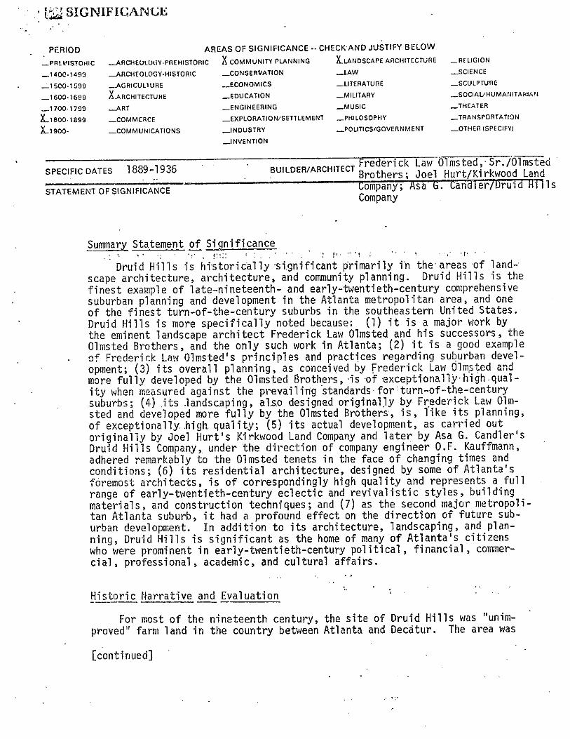
1~ SIGNIFICANUE
PERIOD AREAS OF SIGNIFICANCE-S CHECKAND JUSTIFY BELOW
_PREMISTOIIIC _ARcHEUWC;Y-pnEHIsTopIc X COMMUNITY PLANNING ILANDSCAPL ARCHITECTURE _RELIGION
_1400.1493 ....ARCHEOLOGY•HISTORIC ..CONSERVAIION _LAW _SCIENCE
_lSO0.1599 ...AGRICULTURE _ECONOMICS _LITERATURE _SCULPTURE
_l 600.1659 X..ARCHITECTUHE ..._EOUCATION _MILITARY ...SOCIAL/HUMANITAHIAM
....17001?99 _ART _ENGINEERING _MUSIC ..THEATER
)Lieoo. 1899 _COMMCRCE _EXPLORATION,’SETTLEMENT .PHILOSOPHY .._TRANSPORTATIQN
Ligoo- _COMMUNICAT(ONS _INDUSTRY _POLITICS/GOVERNMENT _OTHER (SPECIFY)
...JNVENTION
SPECIFIC DATES 1889-1936 . BUI LDER/ARCHITECT ~ Law Oi msted, Sr./Ol msted
STATEMENTOFSIGNIFICANCE company; Asa S. candTërfUruid HillsCompany
Summary Statement of Significance. ‘
‘:1
Druid Hills is historically significant primarily in theareas of landscape architecture, architecture, and community planning. Druid Kills is thefinest example of late—nineteenth— and early—twentieth—century comprehensivesuburban planning and development in the Atlanta metropolitan area, and oneof the finest turn-of-the-century suburbs in the southeastern United States.Druid Hills is more specifically noted because: (1) it is a major work bythe eminent landscape architect Frederick Law Olmsted and his successors, theOlmsted Brothers, and the only such work in Atlanta; (2) it is a good exampleof Frederick Law Olmsted’s principles and practices regarding suburban development; (3) its overall planning, as conceived by Frederick Law Olmsted andmore fully developed by the Olmsted Brothers, is of exceptionally high quality when measured against the prevailing standards forturn-of~the-centurYsuburbs; (4) its landscaping, also designad originaiJy by Frederick Law Olmsted and developed more fully by the Olmsted Brothers, is, like its planning,of exceptionally. higft quality; (5) its actual development, as carried outoriginally by Joel Hurt’s Kirkwood Land Company and later by Asa Q. Candler’sDruid Kills Company,, under the direction of company engineer O.F. Kauffmann,adhered remarkably to the Olmsted tenets in the face of changing times andconditions; (6) its residential architecture, designed by some of Atlanta’sforemost architects, is of correspondingly high quality and represents a fullrange of early—twentieth—century eclectic and revivalistic styles, buildingmaterials, and construction techniques; and (7) as the second major metropolitan. Atlanta suburb, it had a profound effect on the direction of future suburban development. In addition to its architecture, landscaping, and planning, Druid Hills is significant as the home of many of Atlanta’s citizenswho were prominent in early-twentieth-century political, financial , coninercial, professional, academic, and cultural affairs.
~f!:coric Narrative and Evaluation •
For most of the nineteenth century, the site of Druid Hills was “unimproved” farm land in the country between Atlanta and Decatur. The area was
[continued] . .

• (iiLi~
___________________
UNITED STATES DEPARTMENT OF THE INTERIOR FOR HCRS U~JE ONLYHERITAGE CONSER\’ATION AND RECREATION SERVICE
RECEIVEDNATIONAL REGISTER OF HISTORIC PLACES IATE ENTEPED
INVENTORY--NOMINATION FORM
CONTINUATION SHELT Significance ITEM NUMBER 8 PAGE 2
traversed by Williams Mill Road (later Briarcliff Road) on the west, the Seaboard Coast Line railroad on the east, the turnpike between Decatur and Buck—head (later North Druid Hills Road) on the north, and the Georgia Railroa4 onthe south. Land in this area was generally owned in large agricultural tracts.
During the late 1880s, Joel Hurt conceived of an “ideal residential suburb” to be developed on this land. Hurt was a prominent Atlanta businessmanand developer. In the l880s, he developed Inman Park, Atlanta’s first suburb(listed on the National Register on July 23, 1973), built and operated Atlanta’s first electric street railway from the suburb to the city along EdgewoodAvenue, and commenced planning for Atlanta’s first skyscraper, the EquitableBuilding (later the Trust Company of Georgia Building, demolished in 1971).Druid Kills was thus to be Hurt’s second suburban residential development,and his largest and most comprehensive undertaking.
Between 1889 and 1892, Hurt made several moves toward carrying out hisideas for the new suburb. First; he organized the Kirkwood Land• Company;Several prominent Atlantans were original stockholders in the company, including Robert Lowry, a banker who owned property in the area to be developed.The Kirkwood Land Company then acquired nearly 1 ,500 aëres of land, includingthe John~on, Kilpatrick, Pedan, Washington, Harrison, and Lowry tracts. S.Z.Ruff was hired as company engineer to prepare a topographic map of the hold-i ngs.
In 1892, Hurt secured Frederick Law Olnisted, Sr., as planner and designerfor the new suburb; Apparently, Olmsted was to prepare preliminary overall
‘plans and designs, and company engineer Ruff was to supervise their execution.Between 1892 and 1894, Olmsted visited Atlanta several times for the expresspurpose of consulting with Kurt and visiting the site. Hurt, in turn, visitedOlnisted’s office in Brookline, Mass., on at least one occasion to confer withOlmsted and view the latest suburban developments in the northeast. Considerable correspondence between the two men reviewed these meetings and elaborated upon the major points of discussion. Hurt, for example, wanted Olmstedto move ahead with working drawings for some 600 acres at the outset, whileOlmsted argued for a general plan for the whole 1 ,500-acre suburb before anydevelopment was allowed to take place. Hurt also wanted an arrow-straightprincipal avenue modeled after Edgewood Avenue, which connected his earlierInman Park suburb with Atlanta; Olmsted, characteristically, urged a more
[continued]

FOR IICRS USE ONLY
RECEiVED
DATE ENTERED.
PAGE 3
botanist and established a nur—Here, under Olinsted’s observe—
of exotic and domestic land-
By 1893, Olmsted had prepared a preliminary plan for the new suburb.Olmsted’s plan called for a broad, curving, divided major avenue (Ponce deLeon), with a succession of public parks in the median, bordered by large estates. Secondary streets, narrower in width and also gently curving in alignment, ran northward, more or less perpendicular to the major divided avenue,and were bordered by smaller, long and narrow lots. Olmsted’s plan alsocalled for two artificial lakes and additional park land around them. Thiswas to be Olmsted’s most prestigious Southern work, his first significantwork in Atlanta., and one of the last major works of his career. It embodiedthe genera] principles of suburban development set forth in Oimsted’s firstsuburb of Riverside, to which he steadfastly adhered throughout hi~ career.In general , the plan exhibited the combination of picturesque planning andlandscaping with concern for function and livability that has made Olmsted’swork famous. It also sought to combine, as most of Olmsted’s residentialwork did, the civilizatipn of the city as manifest in modern technology andsophisticated design with the natural attributes of the country in a suburbansetting. Some of the more specific characteristics of the Olmsted plan arealso worth noting. The principal avenue was divided for more than aestheticreasons: one roadway was devoted to through or express traffic, while theother was designated as a more leisurely parkway. The electric trolley linewas placed in the median rather than in the street to separate the differentmodes of transportation and to allow for more effective landscaping of therailbed, tracks, poles, and wires. Each of the series of median parks wasdifferentiated by its landscaping; they ranged from relatively open greens-wards to nearly impenetrable woods. There was a clear hierarchy of streets,depending upon their use, and all streets were sensitively laid into thenatural terrain instead of being imposed upon it. To a large degree, theseaspects of Olmsted’s preliminary plan have been translated into the realityof Druid Kills.
After the preparation of Olmsted’s plan, Hurt intended to proceed immediately with the laying out of rights-of-way, the grading of streets, and the
rrIK;~—)uuR(11/18)
UNITED STATES DEPARTMENT OF THE INTERIORHERITAGE CONSERVATION AND RECREATION SERVICE
NATIONAL REGISTER OF HISTORIC PLACESINVENTORY--NOMINATION FORM
CONTINUATION SHEET Significance ITEM NUMBER 3
picturesque, curving avenue.
At this same time, Hurt became an amateursery on Williams Mill (later Briarcliff) Road.tion, he collected and cultivated a wide rangescaping plants.
[continued]
• F~R-. P.-300AUi/78)
UNITE!) STATES DEPARTMENT OF THE INTERIOR F R !ICR~ UCE ON! yHERITAGE CONSERVATION ~D RECREATiON SERVICE
0
RECEiVED
NATIONAL REGISTER OF HISTORIC PLACES DATE ENTEREDINVENTORY-- NOMINATION FORM —. -__
CONTINUAT~0N SHEET Significance ITEM NUMBER 8 PAGE 4
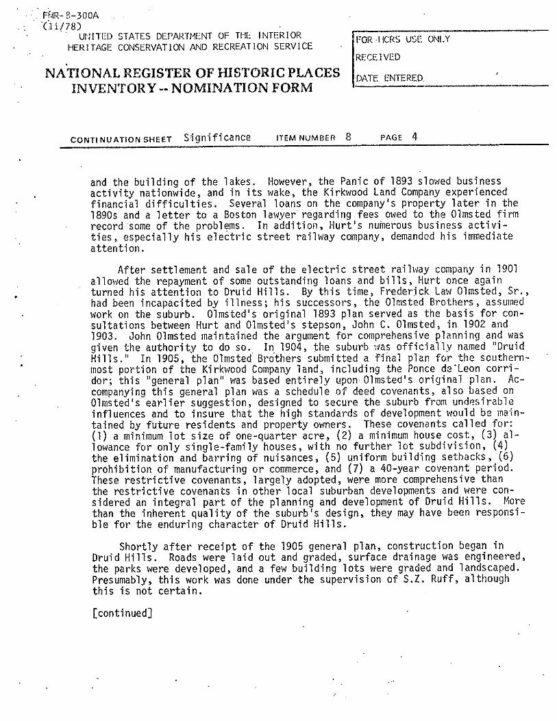
and the building of the lakes. However, the Panic of 1893 slowed businessactivity nationwide, and in its wake, the Kirkwood Land Company experiencedfinancial difficulties. Several loans on the company’s property later in the189Os and a letter to a Boston lawyer regarding fees owed to the Olmsted firmrecord some of the problems. In addition, Hurt’s nuinerous business activities, especially his electric street railway company, demanded his immediateattention.
After settlement and sale of the electric street railway company in 1901allowed the repayment of some outstanding loans and bills, Hurt once againturned his attention to Druid Hills. By this time, Frederjck Law Olmsted, Sr.,had been incapacited by illness; his successors, the Olmsted Brothers, assumedwork on the suburb. Olnisted’s original 1893 plan served as the basis for consultations between Hurt and Olmsted’s stepson, John C. Olmsted, in 1902 and1903. John Olmsted maintained the argument for comprehensive planning and wasgiven the authority to do so., In, 1904, the suburb was officially named ‘DruidHills.” In 1905, the Olmsted Brothers submitted a final plan for the southernmost portion of the Kirkwood Company land, including the Ponce daLeon corridor; this “general plan” was based entirely upon Olmsted’s original plan. Ac—coinpanying this general plan was a schedule of deed covenants, also based onOlmsted’s earlier suggestion, designed to secure the suburb from undesirableinfluences and to insure that the high standards of development would be maintained by future residents and property owners. These covenants called for:(1) a minimum lot size of one-quarter acre, (2) a minimum house cost, (3) allowance for only single—family houses, with no further lot subdivision, (4)the elimination and barring of nuisances, (5) uniform building setbacks, (6)prohibition of manufacturing or commerce, and (7) a 40-year covenant period.These restrictive covenants, largely adopted, were more comprehensive thanthe restrictive covenants in other local suburban developments and were considered an integral part of the planning and development of Druid Kills. Morethan the inherent quality of the suburb’s design, they may have been responsible for the enduring character of Druid Hills.
Shortly after receipt of the 1905 general plan, construction began inDruid Kills. Roads were laid out and graded, surface drainage was engineered,the parks were developed, and a few building lots were graded and landscaped.Presumably, this work was done under the supervision of S.Z. Ruff, althoughthis is not certain.
[continued]

• rHR4—300A(11/18)
UNITED STATES DEPARTMENT OF THE INTERIOR FOR lICkS USE ONLYHERiTAGE CONSERVATION I-V’J[) RECREATiON SERVICE
RECEIVED
NATIONAL REGISTER OF FIISTORIC PLACES DATE ENTFRED• INVENTORY-- NOMINATION FORM
CONTINUATION SHEET Significance ITEM NUMBER 8 PAGE 5
In 1908, the Kirkwood Land Company and its holdings in Druid Hills werepurchased by a consortium of local businessmen. Circumstances surroundingthe sale are unclear, but the sale price of $500,000 constituted the largestreal-estate transaction in Atlanta’s history. The new owners subsequentlyorganized the Druid Hills Company. Coca—Cola magnato Asa Griggs Candlerassumed the presidency; Forrest and George Adair, real-estate brokers, servedas vice-president and secretary—treasurer respectively.
‘The Druid Hills Company made several changes in the planning and development of the Druid Hills suburb. Although the new company insisted that itwould follow “in the main” the original plans of Frederick Law Olmsted asamended by the Olmsted Brothers, it imediately notified the Olmsted Brothersthat their services were “no longer required” and then hired a new company
- engineer, 0.F. Kauffmann, to prepare revised plans and working drawings. Previously established parts of the suburb, including the Ponce de Leon corridor,were left largely unchanged, but modifications were made elsewhere. Between1908 and 1911, for example, much property was sys~erñatica3ly repiatted. • Lotsbecame progressively smaller~ as time went on. Plans for the two lake~ werepermanently shelved. Some intersections and stretches of roadway wpre realigned. Deed restrictions became progressively less restrictive and shorterin term.. Sales of building lots were handled exclusively by the Forrest andGeorge Adair real-estate agency.
Between 1908 and 1936, the Druid Hills Company successfully carried outthe development of Druid Hills according to these new policies and procedures.The result was one of the finest early-twentieth-century suburbs in Atlantaand the Southeast. The decision to replat lots and eliminate some luxuriesseems to have been based on a clear understanding of the changes taking placein the residential real-estate market of the time. Turn-of-the-century visions of mansions and estates were being replaced by the realities of periodhouses on modest, manageable lots. Furthermore, coordinated sales of lotsthrough the Adair real—estate agency provided a degree of harmonious development otherwise unobtainable. Throughout, however, the legacy of FrederickLaw Olmsted and the Olmsted Brothers is evident. Olmsted’s original plansfor the Ponce de Leon corridor have survived more or less intact~ his plansfor the entire suburb as amended by the Olmsted Brothers served as the framework for later developments, and the Olmsted design philosophy perseveredthrough the two development companies and two company engineers. -
[continued]

I’ol~ HCRS USE ~Y~LY —
RECEIVED
DATE ENTERED.
PAGE 5
The residences built in Druid Hills during the early—twentieth centuryare among the finest examples of period architecture in the Atlanta metropolitan area and the state of Georgia. These period houses range from mansionsto bungalows, with a concentration in the middle range. The~’ partake of awide variety of eclectic and revivalistic styles, with the Georgian, Tpdor,Jacobean, and Italian Renaissance represented in greatest numbers. Significant period materials include brick, tile, slate, half-timber, weatherboard,and shingle. Construction techniques are typically load—bearing masonry orwood frame with veneer. Although varied in design, the Druid Hills housesare related in terms of their period characteristics, setbacks, and site landscaping.
Some of Atlanta’s most distinguished early-twentieth-century architectsdesigned houses in Druid Hills. The list of these includes Walter T. Downing;Arthur Neal Robinson; Henry Hornbostel; Hentz, Reid, and Adler; Hentz, Adler,and Shutze; and Pringle and Smith . Several of these architects haye more thanone example of their work represented in the suburb; Neal Reid, for example,designed at least six houses of differing styles in addition to his own Georgian Revival home (1914).
Landscaping of private grounds around houses in Druid Hills was designedin a variety of ways. In some cases, the architect of the house suggestedplans for landscaping. In other cases, the architect would subcontract witha landscape architect. In still other cases, independent landscape gardenersprovided their services directly to the property owners; one such firm knownto have been active in Druid Hills was the C.A. Dahl Company of Atlanta,whose motto was, “You build your house, let us make it a home.” Regardlessof the means, almost all landscaping led to the same• end: informal “English”landscaping with an emphasis on broad, undulating lawns and casually disposedtrees, shrubbery, flower gardens, and walks.
Little is known at the present time about the contractors who actuallybuilt Druid Hills.
It is important to note that the design and construction of houses andlandscaping was not provided by the Druid Kills Company but rather by eachproperty owner independently with the professionals of the owner’s choice.
F~iR- 8—300A(u/78)
UNITED STATES DEPARTMENT OF THE INTERIORHERITAGE CONSERVATION ~ND RECREATION SERVICE
NATIONAL REGISTER OF HISTORIC PLACESINVENTORY-- NOMiNATION FORM
CONTINUATON SHEET Significance ITEM NUMBERS
[conti nued]

~5tiR-B—3OOA- (U/78)
____________________
* UNITED STATES DEPARTMENT OF THE INTERIOR ro’~ ticks USL: ONLYHERITAGE CONSERVATION AND RECREATION SERVICE I -
• RECEIVED
• NATiONAL REGISTER OF HISTORIC PLACES DATE ENTEREDINVENTORY-- NOMINATION FORM
CONTINUATION SHEET Significance ITEM NUMBER 8 PAGE 7
That such an arrangement produced results characterized by the harmony andgrace of Druid Hills is a testimony to the strength of early-twentieth-century period design.
The planning and development of Druid Hills exerted a powerful influenceon the direction of future suburban development in the Atlanta area. Mostsignificantly, as a major real—estate undertaking, it strengthened the movetoward suburban residency and away from downtown residency. Along with InruanPark, Joel Hurt’s earlier suburb, it shifted the course of suburban residential development from the south to the east and northeast. The establishmentof the Ponce de Leon corridor connecting eventually to Peachtree Road bolstered the suburban development of north Atlanta. It set an example to beemulated in such developing areas as Ansley Park, the West Paces Ferry Roadneighborhood, Brookwood Hills, and, on a more modest scale, Morningside.Local designers who were not just influenced but actually trained in the Olnisted way at Druid Hills include S.Z. Ruff, the Kirkwood Land Company engineer who later designed Ansley Park for the South-Eastern Real Estate Improve—went Company (listed on the National Register on April 20, 1979), and 0.F.Kauffmann, the Druid Hills Company engineer who platted many significant suburban subdivisions.
The historical significance of Druid Hills. as a suburb cannot be divorcedfrom the historical significance of the many prominent Atlanta citizens whomade Druid Hills their home in the early-twentieth century. Thesecitizensconstituted much of the leadership in Atlanta’s political, financial , commercial, professional, academic, and cultural affairs. Chief among them was AsaGriggs Candler, founding president of the Coca-Cola Company, who has alreadybeen mentioned as not only living in the Druid Hills neighborhood but, aspresident of the Druid Hills Company, playing an important role in its planning and development. Two generations of the Candler family lived in DruidHills, as did many executives of the Coca-Cola Company, the Coca-Cola BottlingCompany of Atlanta, and the Trust Company of Georgia. Candler’s land grant and endowment of Emory University, located immediately northeast of Druid Hills,not only insured the future of this educational institution, but more or lessguaranteed a body of academic and professional people seeking homes in nearbyDruid Hills. Other Druid Hills residents, generally not as well known asCandler, also contributed to the history of the city. Guy Woolford, who lived
[continued]
141X.- 0z)UUR(Ii / /8)
______________________
• UNITED STATES DEPARTMENT OF THE INTERIORFOR HCRS USE ONLY
HERITAGE CONSERVATION AND RECREATION SERVICERECEIVED
NATIONAL REGISTER OF HISTORIC PLACES DATE ENTERED• INVENTORY--NOMINATIONFORM - -
CONTINUA11ON SHEET Significance ITEM NUMBER 8 PAGE 8
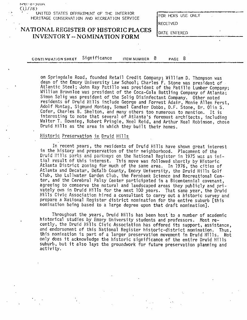
on Springdale Road, founded Retail Credit Company; William D. Thompson wasdean of the Emory University Law School ; Charles F. Stone was president OfAtlantic Steel; John Ray Patillo was president of the Patillo Lumber Company;William Brownlee was president of the Coca—Cola Bottling Company of Atlanta;Simon Selig was president of the Selig Disinfectant Company. Other notedresidents of Druid Hills include George and Forrest Adair, Monie Allen Ferst,Adolf Nontag, Sigmund Montag, Samuel Candler Dobbs, O.F. Stone, Dr. Olin S.Cofer, Charles B. Shelton, and many others too numerous to mention. It isinteresting to note that several of Atlanta’s foremost architects, includingWalter T. Downing, Robert Pringle, Ned Reid, and Arthur Neal Robinson, choseDruid Hills as the area in which they built their homes.
Historic Preservation in Druid Hills
In recent years, the residents of Druid Hills have shown great interestin the history and preservation of their neighborhood. Placement of theDruid Hills parks and parkways on the National Register in 1975 was an initial result of this interest. This move was followed shortly by HistoricAtlanta District zoning for much of the same area. In 1976, the cities ofAtlanta and Decatur, DeKalb County, Emory University, the Druid Hills GolfClub, the Lullwater Garden Club, the Fernbank Science and Recreational Center, and the Cerebral Palsy Center participated in a Bicentennial covenant,agreeing to conserve the natural and landscaped areas they publicly and privately own in Druid Hills for the next 100 years. That same year, the DruidHills Civic Association hired a consultant to carry out a historic survey andprepare a National Register district nomination for the entire suburb [thisnomination being based to a large degree upon that draft nomination].
Throughout the years, Druid Hills has been host to a number of academichistorical studies by Emory University students and professors. Most recently, the Druid Hills Civic Association has offered its support, assistance,and endorsement of this National Register historic-district nomination. Thus,this nomination is part of a larger preservation movement in Druid Hills. Notonly does it acknowledge the historic significance of the entire Druid Hillssuburb, but it also lays the groundwork for future preservation planning andact i vi ty.

U~JMA)UK UIbLLUIil( ‘fl1UALKtiJSKtJNUt~i
Asa Griggs Candler Papers: Boxes 6,7,8 (Druid Killlections, Emory University.
Lyon, Elizabeth, A.M., “Frederick Law Olnisted andin Atlanta, 1890-1894,’ unpublished conference
[continued]
s), Woodruff Library, Special Col—
Joel Hurt:paper, 1972.
~GEOGRAPH1 CAL DATAACREAGE OF NOMINATED PROPERTY app. 1 .300 acres
QUADRANGLE NAME N.E. Atlanta~Ga. QUADRANGLE SCALEUTM REFERENCES
I I I i i__I
I I ~i I
I_
Bhl,61 L714,6181501 L11I.4~21.z~1~JZONE EASTING . NQRTHING
Dj.l ,6l [7li~9l0!2T5] I3i71 31819161 ~jFl__I LII I~J~1 11111
I HI I lli~ i ~VERBAL BOUNDARY DEScRIPn0N —__________
Boundaries for the Druid Hills historic district are described by heavy black lineson thèuattached “Maps~ of~ the Druid Hills Historic District” (four ~heetts)
LIST ALL STATES AND COUNTIES FOR PROPERTIES OVERLAPPING STATE OR COUNTY BOUNDARIES
STATE CODE COUr4TY CODE
STATE CODE COUNTY ~. CODE ——
~FORM PREPARED BY -
~ NAME/TITLE Richard Cloues, architectural histor~an -
Kenneth H. Thomas, Jr., historian ——________________
ORGANIZATION DAlE
Historic Preservation Sec., Georgia DNR June 26, 1979STREET& NUMBER TELEPHONE
270 Washington St.; S.W. . (4.04.) ~5.6:~284QCITY OR TOWN STATE
Atlanta
~STATh HISTORIC PRESERVATION OFFICER CERTIFICATIONTHE EVALUATED SIGNIFICANCE OF THIS PROPERTY WITHIN THE STATE IS:
NATIONAL..L STATE_ LOcAL_
As the designated State -Ustoric Preservation 0& for:the Nationai ~1istoric.Presprv~tion Ac~ 9Ltg66 (Public Law 89-663). I
hereby nominate this property for inclusion in the National Register and certify that it has been evaluated according to thecriteria and procedures set forth by the National Park S .~ce.
STATE HISTORIC PRESERVATION OFFICER SIGNATURE ~Jej/)
Planning the Environment
~40EASTIN C1714181l19r01
Al 1161ZONE
ci 1 ~6I
El I I
oL I
13171 3t9~_~1_j~QJNO EU 111 NC13,7141118,0101
F’
TITLEState Historic~
A. Lyon ~DATE
RJRNPSUSEONIYI I-’EPEBY cEPJIFV THAT ThIS DROPERTY IS INCLUDED IN THF NATIONAL RtC’STER
: u . DATE -
KEEPER OF ThE NATIONAL REGiSTER - .
ATTEST; — — .... . .. . . . DATE
CHlEF OF REG4STRATK)i4 . . .
GPO ~21-SO~.

IitlR—&-5IJU/\ -
• Gii//8)
_________________
• A UNITED STATES DEPARTMENT OF THE INTF.:RIOR - ~., ,j-r C ic:- — — , ti).. —
HERITAGE CONSERVA1 ION AND RECREATION SERVICERECEIVED
NATIONAL REGISTER OF HISTORIC PISACES DATE ENTERED
____
INVENTORY-- NOMINATION FORM - —-___
CONTI NUATION SHEET Bibliography ITEM NUMBER 9 PAGE 2
Frederick Law Olmsted and Olmsted Assoc.. Collections of the Library of Con.:gress.
Marks, Randolph C., “Druid Hills Historic District,” National Register nomination (draft), September 15, 1976. -
Lyon, Elizabeth A., “Druid Hills Parks and Parkways,!’ National Register noniin—ation, November, 1974.

•~flcnZ cn >0~OflO ~ rtpz
11 I-’SrtZf~art H P)CDOØ~(DZ 0 t”$og~,”.. ~ no
~ >~
0’ II i—-iI_a.rt
P..rtc1~0 —
m~.-- fin CD
it•0’•
- 01_a.
%%%%%% -
Ga
H ct-i 0fri1I~1. 0
SI I.F’ • ~•‘ I
(H • • (_~ ‘~-.--~- Kit - - - -t ~...
..
• I

~jLE coi-~u/FHR.-S--3~O (li—n)
United States Department of the InteriorHeritage Conservation and Recreation Service
National Register of Historic PlacesInventory—Nomination FormSee instructions in How to Complete National Register Forms ,., ,Type all entries—complete applicable sections 12O O 7&&21. Namehistoric Cameron Court
and or common same
2. LocationStreet & number Cameron Court NIL not for publication
city, town Atlanta 3k vicinity of asnprssels..al distritt —
stateGeorgia
code 013 county DeKaib code 089
3. ClassificationCategory Ownership Status Present Use
J!district public L occupied agriculture — museumbuilding(s) ._L. private — unoccupied commercial — parkstructure — both — work in progress educational ._L. private residencesite Public Acquisition Accessible — entertainment — religiousobject liLt. In process — yes: restricted government — scientific
being considered X yes: unrestricted — Industrial — transportationno — military — other:
4. Owner of Propertyname Multiple owners (23)
street & number
city, town — vicinity of state
5. Location of Legal Descriptioncourthouse, registry of deeds, etc. Superior Court
street & number DeKaib County Courthouse
city, town Decatur state Georgia
6. Representation in Existing SurveysHistoric Structures Field Survey:
title Dexalb County, Georgia has this property been determined elegible? — yes ._1. no
date 1975—1981— federal .JL state — county — local
depository for survey records Department of Natural Resources
city, town Atlanta state Georgia

7. Description U JCondition Check one Check one
excellent — deteriorated — unaltered original site.1,,,,, good — ruins altered — moved date
fair — unexposed
Describe the present and original (if known) physical appearance
Cameron Court is a~ •sma1~ single—family residential subdivision dating from the midto late 1920’s. It is located in the midst of a vast early twentieth century suburbanarea, some three miles northeast of downtown Atlanta. Cameron Court lies just beyondthe western edge of Druid Hills., a nationally significant suburban developmentoriginally planned by Frederick Law Olmsted.
Cameron Court consist-s of a. single short cul—de—sac street running eastward fromBriarcliff Road, a major-metropolitan—areathoroughfare. The street follows a gentlymeandering, course across gradually sloping terrain. Small, uniform, ~rectangularshaped lots, measuring only fifty feet by one hundred and fifty feet, line both sidesof the street; an additional three lots front. on Br±arcliff Road.. Houses are situatednear the front ceater of these lots. The houses are relatively small one and one—and—a—half story detached single—family dwellings.. They were built in the mid to late1920’s. Predominant architectural styles are Craftsman/Bungalow, Spanish Mission,Tudor, and Colonial. Exterior walls are veneered in either brick or stucco, with wooddetailing. Original tiles or slates remain on many roofs; others are covered withreplacement asphalt shingles. Recessed porches, bracketed pedtnents, half timbering,and exposed rafter ends or boxed cornices are characteristic architectural details.The houses are uniformly sized, share a common setback line, axid. stand relativelyclose together, creating an almost rowhouse—like effect along the street. ftontyards are informally landscaped with trees, shrubbery, lawn, and hedges, and theyblend together to create a relatively uniform streetscape. The street itself islined with sidewalks and bordered by curbs. Stone gateposts stand to either side ofthe Briarcliff Road entrance to the subdivision.
Non—contri&iting ~roperties
There are ho~ nbn—dont±ibut~ng pro’perties in the Cameron Cburt historic district.A few houses have been remodeled on the exterior and/or the interior, but none soextensively a’~ to have lost its identity as a historic structure. One vacant lot,which was never built upon, is located at the extreme, eastert end of the subdivision.
Boundaries
Boundaries for the Cameron Court historic district coincide with the historicplattedlimits of the Cameron Court subdivision. They circumscribe an intact historic suburban residential development. North of the historic district are early to
mid twentieth century suburban houses built after., and independently of Cameron Court.
To the east and south is the Druid Hills subdivision. West of Cameron Court, across
Briarcliff Road, are much larger historic houses and large—scale,. multi—family resi
dential complexes.
Photographs . -
The Historic Preservation Section has determined that the photographs taken in
February 1981 still represent the character and appearance of the district. No
significant.changes have taken place since then.
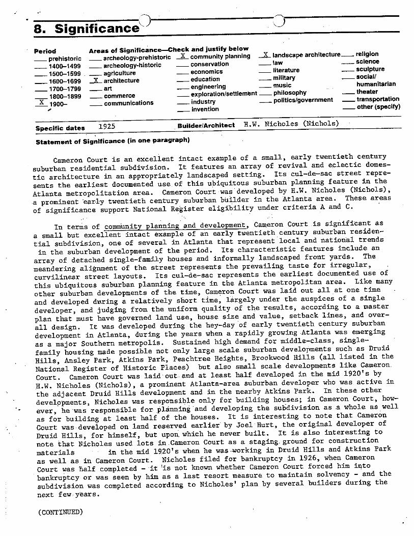
U8. Significance’Period Areas of Significance—Check and justify below
— prehistoric — archeology-prehistoric .JL community planning _L landscape architecture._ religion
— 1400—1499 — archeology-historic — conservation — law — science
— 1500—1599 — agriculture — economics — literature — sculpture
— 1600—1699 JL. architecture — education — military — social?
— 1700—1799 — art — engineering music humanitarian
— 1800—1899 — commerce — exploration/settlement — philosophy — theater
1900— — communications — industry — politics/government — transportation
— invention — other (specify)~0
Specific dates 1925 Builder/Architect H.W Nicholes (Nichols)
Statement of Significance (in one paragraph)
Cameron Court is an excellent intact example of a small, early twentieth century
suburban residential subdivision. It features an array of revival and eclectic domes
tic architecture in an appropriately landscaped setting. Its cul—de—sac street repre
sents the earliest documented use of this ubiquitous suburban planning feature in the
Atlanta metropolitation area. Cameron Court was developed by H.W. Nicholes (Nichols),
a prominent early twentieth century suburban builder in the Atlanta area. These areas
of significance support National Register eligibility under criteria A and C.
In terms of comniunity planning and development, Cameron Court is significant as
a small but excellent intact example of an early twentieth century suburban residen
tial subdivision, one of several in Atlanta that represent local and national trends
in the suburban development of the period. Its characteristic features include an
array of detached single—family houses and informally landscaped front yards. The
meandering alignment of the street represents the prevailing taste for irregular,
curvilinear street layouts. Its cul—de—sac represents the earliest documented use of
this ubiquitous suburban planning feature in the Atlanta metropolitan area. Like many
other suburban developments of the time, Camçron Court was laid out all at one time
and developed dt~ring a relatively short time, lérgely under the auspices of a single
developer, and judging from the uniform quality of the results, according to a master
plan that must have governed land use, house size and value, setback lines, and over
all design. It was developed during the hey—day of early twentieth century suburban
development in Atlanta, during the years when a rapidly growing Atlanta was emerging
as a major Southern metropolis. Sustained high demand for middle—class, single—
family housing made possible not only large scale suburban developments such as Druid
Hills, Ansley Park, Atkins Park, Peachtree Heights, Brookwood Hills (all listed in the
National Register of Historic Places) but also small scale developments like Cameron.
Court. Cameron Court was laidout and at least half developed in the mid 1920’s by
H.W. Nicholes (Nichols), a prominent Atlanta—area suburban developer who was active in
the adjacent Druid Hills development and in the nearby Atkins Park. In these other
developments, Nicholas was responsible only for building houses; in Cameron Court, how
ever, he was responsible for plánnin~ and developing the su1~division as .a whole as well
as for building at least half of the houses. It is interesting to note that Cameron
Court wasdeveloped on land reserved earlier by Joel Hurt, the original developer of
Druid Hills, for himself, but upon. which he never built. It is also interesting to
note that Nicholes used lots in Cameron Court as a staging- ground for construction
materials in the mid 1920’s when he was -Morking in Druid Hills and Atkins Park
as well as in Cameron Court. Nicholes filed for bankruptcy in 1926, when Cameron
Court was half completed — - it j~ not known whether Cameron Court forced him into
bankruptcy or was seen by him as a last resort measure to maintain solvency — and the
subdivision was completed according to Nicholes’ plan by several builders during the
next few years.
(CONTINUED)

NPS Form 10 900-i 0MB No 1024—0018(342) ) ~ J Exp 10—31—84
United States Department of the InteriorNational Park Service III~IsI!IIIIIsNational Register of Historic PlacesInventory—Nomination Form ~I1~~IIIiPi’Continuation sheet Significance Item numbel Page 2
In terms of architecture, Cameron Court is significant for its collection ofmodestly—sized single—family houses. These houses represent the prevailing designprinciples and construction practices of early twentieth century domestic suburbanarchitecture. Excellent example of revival styles such as Colonial, Tudor, and SpanishMission, and of then—comteznporary styles such as Craftsman/Bungalow, are present inthe district. Such houses are commonly associated with early twentieth century suburban architecture in Atlanta and elsewhere. They exhibit such characteristic earlytwentieth century building materials as brick, stucco, tile, slate, and half timbering,and they illustrate early twentieth century construction methods, particularly theballoon frame with veneer. Individually and collectively they maintain a high degreeof integrity, which makes their architectural value all the more pronounced. Because of the apparently strict design controls under which they were produced, theyrelate well to one another in tens of size, massing, siting, materials, and detailing.At least half of the houses were built by prominent Atlanta—area suburban developerH.W. Nicholes (Nichols) (See above). It is interesting to 9ote that many of thesemodestly—sized houses are similar in design to their much l~xger counterparts in theadjacent Druid Hills development and in fact were built out of the very same highquality building materials that went into Nicholes’ Druid Hills houses.
In terms of landscape architecture, Cameron Court is significant for its informally landscaped front yards, its sidewalks, and its street curbs, all characteristicfeatures of early twentieth century suburban landscaping. Front yards informallylandscaped with trees, lawn, and shrubbery, blending together to create a park—likeimpression along the street, are among the great achievements in early twentiethcentury Anerican landscape gardening, and Cameron Court is a good albeit modest exampleof this common but characteristic landscaping feature in this type of development.The stone gateposts at the Briarcliff entrance to Cameron Court,similar to butsmaller than those of the nearby and slightly earlier Atkins Park, are distinctivelandscaping features
9. Major Biblioflphical ReferenceCLichtenstein, Marshall, et. al., “Preliminary National Historic Register Application for
Cameron Court Subdivision,” September 22, 1980 (on file at the Historic Preservation, Georgia Department of Natural Resources, Atlanta).
10. Geographical DataAcreage of nominated property 6 acres (estimated)
Ouadrpngle name Northeast Atlanta, CA Quadrangle scale 1:24000UMT References
BI II I II
Zone Easting Northing
cli_1111111111111111 Dli) Ill till iLlEl I II I I nj I F I I I Fl Li I I p I ii
GI II I ill i I i I I I I H) I I I i I i i I I i I i I I I I
Verbal boundary description and justification Boundary is described by a heavy black line onthe accompanying sketch map and is justified in Section 7.
List all states and counties for properties overlapping state or county boundaries
state N/A code county code
state N/A code county code
11. Form Prepared Byname/title Richard Cloues, Nato~al Register Coordinator
. Ristoric Preservation Sectionorganization Ceorgia Department of Nstural Resources date August 12, 1982
street& number 270 Washington Street, S.W. telephone 404/656—2840
city or town Atlanta state Georgia
12. State Historic Preservation Officer CertificationThe evaluated significance of this property within the state is:
national — state local
As the designated State Historic Preservation Officer for the National Historic Preservation Act of 1966 (Public Law 89—665), I hereby nominate this property for inclusion in the National Register and certify that it has been evaluatedaccording to the criteria and procedures set forth by the Heritage Conservation and Recreation Service.
State Historic Preservation Officer signature F2LIJPJJ.J ~ c~4~tn_._
Zone Easting
A 116 I j7 I~ 161216 101 l~ ~ l~ il 12 319JNorthing
title State Historic Preservation Officer
ForHcRsuBeoniVr(~ØI hereby certify that this
C Elizabeth A.~’Lyon
Keeper of the N
Attest:
date
Chief of
date

-— 435’
Z tn >0Z~O C ~ rrgzC~ ‘1 P1 i-~~rtZ ft ~-3 m~00- ~ 0 ~Pi
DQI~~ Z c-tofrjIj
z> 40fr~ 1.1.0
DC
Zr,0_I-’
Co C,0_ft ‘4
H. fri• 01-”• CD
ft1-1.0.. .
OH.Zco a’OH
SI
~ ~hC~.;-*~
P/Pt) £-ZV-’~-7NPS Form 10-900
0MB lb 1024-re
United States Department of the IntenorNational Park Service
NATIONAL REGISTER OF HISTORIC PLACES REGISTRATION FORM
This form is for use in nominating or requesting determinations of elig bility for individual properties or districts See instructions in ouidelines for compleurc
National Register Forms” (Nationa Register Bulletin 16) Complete each item by marking Yin the appropriate Dcx or by entering the requested informati~
if an item does not apply to the property be ng documented enter “N A” for “not applicable - For functions. styles mater as and areas of significance e
only the categories and subcategories sted in the instructions For additional space use continuation sheets (Form 10-900a Type all entries
1. Name of Property
historic name University Park-Emory Highlands-Emory Estates Historic District
other names/site number N/A
2. Location
street & number Roughly bounded by North Decatur Road Durand Drive, Peavine Creek, and
the Druid Hills Historic District.
city, town Decatur (x) vicinity of
county DeKaIb code 089state Georgia code GA zip code 31051
not for publication
3. Classification
Ownership of Property: Category of Property:
(x) private ( ) building(s)public-local (x) districtpublic-state ( ) sitepublic-federal ( ) structure
object
Number of Resources within Property: Contributing Noncontributing
buildings 150 31sites 1 0structures 0 0objects 0 0total 151 31
Contributing resources previously listed in the National Register: N/AName of previous listing N/AName of related multiple property listing: N/A

~.
StatelFederal Agency Certification
As the designated authority under the National Historic Preservation Act of 1966, as amended, I hereby certifythat this nomination meets the documentation standards for registering properties in the National Register ofHistoric Places and meets the procedural and professional requirements set forth in 36 CFR Part 60. In myopinion, the property meets the National Register criteria. ()See continuation sheet.
___________________________
~1~k 7’) I9~Signature of certifying official Date
Mark R. EdwardsState Historic Preservation Officer
In my opinion, the property () meets ( ) does not meet the National Register criteria. ()See continuation sheet.
Signature of commenting or other official Dale
State or Federal agency or bureau
5. National Park Service Certification
I, hereby, certify that this property is:
() entered in the National Register
()determined eligible for the National Register
()deterrnined not eligible for the National Register
()removed from the National Register
() other, explain:
()see continuation sheet
_____________________________________
Keeper of the National Register Date
Unwersity Park-Emory Highlands-Emory Estates Historic District. DeKaIb County. Georgia 2

6. Function or Use
Historic Functions:
Domestic: single dwelling
Current Functions:
Domestic: single dwellingDomestic: multiple dwelling
7. Description
Architectural Classification:
Late 19th and 20th Century Revivals: Tudor Revival, Colonial RevivalLate 20th Century American Movements: Bungalow/Craftsman
Materials:
foundation Concretewalls Woodroof Asphaltother Brick
Description of present and historic physical appearance:
The University Park-Emory Highlands-Emory Estates Historic District is an approximately 67-acre
residential neighborhood located south of Emory University in DeKaIb County, Georgia. The historic
district is roughly bounded by North Decatur Road to the north, Peavine Creek to the south, Durand
Drive to the east, and the Druid Hills Historic District to the west. The neighborhood is organizedalong the north-south trending Emory, Ridgewood, and Durand drives; these last two are joined byBurlington and Emory circles. The terrain features hills but most)y slopes from North Decatur Roaddown to Peavine Creek.
Development in the district occurred in three phases, from 1916 to 1943. First, the L-shapedUniversity Park development was laid out in 1916 (Attachment A). In 1923, the smaller EmoryEstates was laid out (Attachment B). Lastly, in 1925, Emory Estates was laid out (Attachment C).The three developments are indistinguishable from one another. The roads run seamlessly among
each development and the houses throughout the district feature uniform setbacks with large frontlawns and paved driveways (photos 15, 16, and 21). The architectural styles and house types arerepresented in each of the three developments. The same architectural styles--Craftsman-stylebungalows, English Vernacular Revival-style houses, and two-story, brick-and-frame ColonialRevival-style dwellings—are found in each of the three developments.
university Park-Emory Highlands-Emory Estates Historic District, DeKatb County, Geocgia 3
NPS Fomi 10-900-a 0MB Approved No, 1024-0)18
United States Department of the interiorNational Parl Seivice
National Register of Historic PlacesContinuation Sheet
Section 7--Description
426 Emory Drive is typical of the Colonial Revival-style houses found throughout the historic district
(photo 3). It is a two-story, three-bay, frame dwelling with a side-gable roof and end chimney. The
main facade is symmetrically arranged with a center entrance that includes a small porch andfanlight above the door, and double and tripartite windows on each side. The exterior is clad inweatherboard. Numerous Colonial Revival-style house are located at the north end of Emory Drive
(photo 2).
Several hoUses at the foot of Emory Drive (photo 5) are characteristic of the many Craftsman-stylebungalows found in the historic district. 390 Emory Drive is a one-story, gable-front dwelling with a
jerkinhead roof. Large brackets support the entrance stoop. 396 Emory Drive is a one-story, brick
dwelling with a side gable roof and a small entrance porch supported by Tuscan columns. Its multi-
pane windows feature Craftsman-style muntins. Other bungalows appear in photos 8, 10, and 12.
Another house style common to the historic district is the English Vernacular Revival style, alsocalled the Tudor revival style (photo 17). 486 Emory Circle features many characteristics of thestyle: asymmetrical massing, steeply pitched gable roof, and front-facing chimney. 490 Emory Circle,also seen in photo 17, features half-timbered gable ends, another characteristic of the style. OtherEnglish Vernacular-style houses appear in photos 21 and 23.
Most lots in the historic district feature a variety of mature plantings with some landscape features
located near or along the street. Sidewalks with planting strips and granite curbs border the streets.
The intersections of Emory and Ridgewood drives and Durand Drive and Emory Circle (photo 20)feature landscaped traffic islands. Several residences feature frame garages and caretaker cottagesset to the rear of the lot.
The plan for University Park reserved a small, wooded area in the middle of the block betweenEmory and Ridgewood drives. In circa 1930, a small log cabin was constructed for neighborhoodGirl Scouts to use as a meeting house. The cabin survives, although the property is now privatelyowned and the cabin is used as rental property.
The historic district contains noncontributing resources scattered throughout the district, but mostlyin three areas. A significant number of noncontributing properties are located on the south side ofNorth Decatur Road, the north boundary of the historic district. Most of these noncontributingproperties are one- and two-story houses built after the period of significance. The three exceptionsare 1743 and 1767 North Decatur Road, a one-two-story motel/apartment building and a two-storymotel, and 1795 North Decatur Road (photo 13), a two-story apartment building. A row of fournoncontributing houses are located on the east side of Ridgewood Drive between Vickers Drive andBurlington Circle. These are all houses, including large, two-story homes and a small ranch-typehouse, which were built after the period of significance. A row of noncontributing buildings is located
University Park-Emory Highlands-Emory Estates Historic District. DeXaib County. Georgia 4
NPS Form 1O-~-a 0MB Approved No. ¶O24-~18
United States Department of the Interi&National Paric SeMot
National Register of Historic PlacesContinuation Sheet
Section 7--Description
on the east side of Durand Drive. These are mostly ranch-type houses constructed in the 1 950s and1960s.
The majority of noncontributing properties are single-family houses that are consistent with the size,scale, and use of the historic dwellings (photo 14). In many cases, the materials are similar. Theprincipal exceptions are the two motel buildings on North Decatur Road. Most of the noncontributingproperties maintain setbacks that are consistent with the historic streetscape and the lots associatedwith them are typically landscaped so that the nonhistoric houses are not intrusions, but blend intostreetscape. Noncontributing houses on Durand are set further from the road and screened byvegetation (photo 22). Few of the historic lots have been combined or subdivided.
University ParI-Emery Highlands-Emory Estates Historic District, DekaIb County, Georgia 5
8. Statement of Sign ificance
Certifying official has considered the significance of this property in relation to otherproperties:
nationally ( ) statewide (x) locally
Applicable National Register Criteria:
(x)A ( )B (x)C ( )D
Criteria Considerations (Exceptions): (x) NIA
)A ( )B ( )C ( )D ( )E ( )F ( )G
Areas of Significance (enter categories from instructions):
ArchitectureLandscape ArchitectureCommunity Planning and Development
Period of Significance:
1916-1943.
Significant Dates:
1916- Druid Hills Company laid out University Park.1923 - Druid Hills Company laid out Emory Highlands.1925 - Empire Trust Company laid out Emory Estates.
Significant Person(s):
N/A
Cultural Affiliation:
N/A
Architect(s)/Builder(s):
0. F. Kauffman, engineer.J. T. Nash, engineer.
Ur*eersity Park-Emory Highlands-Emory Estates Historic District, DeKaib County, Georgia 6

NPS Form 1Q-~O-a 0MB Approved No. 1Q24-~18
United States Department of the InteriorNational Park Service
National Register of Historic PlacesContinuation Sheet
Section 8--Statement of Significance
Narrative statement of significance (areas of significance)
The University Park-Emory Highlands-Emory Estates Historic District is significant under the themesof architecture, landscape architecture, and community planning and development. In the area ofarchitecture, the historic district is significant because it features a variety of architectural styles andtypes built in Georgia during the first half of the 20th century. Small, Craftsman-style bungalows andEnglish Vernacular-style cottages are the most common house types, although larger, two-storyColonial Revival-style dwellings are also located in the district. These house types are foundthroughout west DeKaIb County and in neighboring Druid Hills.
The University Park-Emory Highlands-Emory Estates Historic District is significant in the area oflandscape architecture because its plan, developed in three phases from 1916 to 1943, featuresmany design elements that are characteristic of neighboring Druid Hills, which was designed byFrederick Law Olmsted and the Olmsted Brothers. Curved elements on Burlington Road and EmoryCircle (photos 10 and 24) and two landscaped traffic islands indicate the influence of the Druid Hillsplan (photo 24). In addition, the mature plantings, sidewalks with planting strips, and granite curbs inthe University Park-Emory Highlands-Emory-Estates Historic District are also design elements foundin Druid Hills.
However, unlike Druid Hills, lots in the University Park-Emory Highlands-Emory-Estates HistoricDistrict are both smaller and uniform in size. Although the roads feature curved elements, they arelaid out on a north-south axis (photos 15 and 16) unlike those in Druid Hills, which are trulycurvilinear streets.
In addition, the historic district is significant under the theme of community planning anddevelopment because its smaller lot sizes and uniform layout reflect the increased demand formoderate housing at the beginning of the 20th century. West DeKaib County experienced anincrease in the construction of housing to support not only those who worked four miles to the west indowntown Atlanta but also residents that worked in nearby Decatur. Emory University grewsignificantly during the first half of the 20th century, further establishing a need for moderately pricedhouses for its faculty and staff. The historic district represents the emergence of west DeKalbCounty and Emory University as an economic center in suburban Atlanta.
National Register Criteria
AandC.
University Park-Emory Highlands-Emory Estates Historic District, DeKaib County, Georgia 7
NPS Form 10-900-a 0MB Approved No. 1024—0018
United States Department of the InteriorNational Park Service
National Register of Historic PlacesContinuation Sheet
Section 8--Statement of Significance
Criteria Considerations (if applicable)
N/A
Period of significance (justiflcation)
The 191 6-1 943 period of significance begins in 1916 with the development of the first tract of land asUniversity Park and ends in 1943, when the last houses in the historic district were constructed. CityDirectories indicate that the last houses were built along Ridgewood and Durand drives in the early1940s. The intent of this period of significance is to include those dwellings located in the historicdistrict that are associated with the University Park, Emory Highland, or Emory Estatesdevelopments.
Contributing/Noncontributing Resources (explanation, if necessary)
Contributing resources in the historic district are those constructed between 1916 and 1943 that arearchitecturally significant and/or represent a historic theme and retain historic integrity.Noncontributing resources are those constructed after 1943 and those that have lost their historicintegrity. The contributing structure identified in the historic district is the plan of the development,includihg the layout the streets.
Developmental historylhistoric context (if appropriate)
Between 1889 and 1936, Joel Hurt’s Kirkwood Land Company and later Asa G. Candler’s Druid HillsCompany developed neighboring Druid Hills according to plans laid out by Frederick Law Qlmstedand the Qlmsted Brothers. The Olmsted designs for Druid Hills featured curvilinear boulevards andnarrower secondary roads, large irregular-shaped lots, and landscaped medians and parks. In 1908,the Druid Hills Company, which had purchased the Kirkwood Land Company’s holdings in DruidHills, relieved the Olmsted Brothers and made several changes in the planning and development ofthe Druid Hills suburb. Between 1908 and 1911, the Druid Hills Company, under the direction of 0.F. Kauffman, replatted areas to include smaller-sized lots, realigned intersections and roadways, andshelved plans for two lakes.
In 1916, the Druid Hills Company purchased a tract of land bounding the northeast corner of theDruid Hills suburb. University Park, named for its proximity to Emory University, was laid out by 0. F.Kauffman and featured approximately 65 lots along Emory and Ridgewood drives. Extending southfrom North Decatur Road, the lots along Emory Drive are generally uniform in size and shape,
Unrversity Park-Emory Highlands-Emory Estates Historic District, Dekaib county, Geogia 8
NPS Form 10-900-a 0MB Approved No. 1024-0018
United States Department of the InteriorNational Park Service
National Register of Historic PlacesContinuation Sheet
Section 8—Statement of Significance
roughly 60 feet by 200 feet. The lots along the bend on Ridgewood Drive are pie-shaped but appearuniform from the street. Some of the restrictive covenants are contained in the deed when the DruidHills Company sold the development to H. D. Thomson in the 1921. The covenants include minimum60-foot lot widths, minimum $2,500 building costs, and residential use restrictions.
In 1923, Kauffman laid out Emory Highlands, a neighboring tract east of University Park. EmoryHighlands consisted of 58 lots along Burlington Road and Ridgewood Drive between University andNorth Decatur Road. In 1925, J. T. Nash laid out Emory Estates for the Empire Trust Company inAtlanta. The third phase of development, Emory Estates, features 73 lots on Emory Circle andDurand Drive. Although the lots were laid out in 1925, houses continued to be built in the historicdistrict through 1943.
University Park-Emory Highlands-Emory Estates Historic District, DeKaib county, Georgia 9
9. Major Bibliographic References
Ballard, Allan. National Register of Historic Places Registration Form. August 1994. On file at the
Division of Historic Preservation, Georgia Department of Natural Resources, Atlanta, Georgia, with
supplemental information.
Historic Preservation Section, Georgia Department of Natural Resources. Georgia’s Living Places:
Historic Houses in their Landscaped Settings. Atlanta: Historic Preservation Section, Georgia
Department of Natural Resources, 1991.
Previous documentation on file (NPS): (x) NIA
preliminary determination of individual listing (36 CFR 67) has been requested
preliminary determination of individual listing (36 CFR 67) has been issued
date issued:previously listed in the National Registerpreviously determined eligible by the National Registerdesignated a National Historic Landmarkrecorded by Historic American Buildings Survey #recorded by Historic American Engineering Record #
Primary location of additional data:
(x) State historic preservation officeOther State AgencyFederal agencyLocal governmentUniversityOther, Specify Repository:
Georgia Historic Resources Survey Number (if assigned): N/A
University Pad&Emory Highlands-Emory Estates Historic District. Dekaib County, Georgia 10
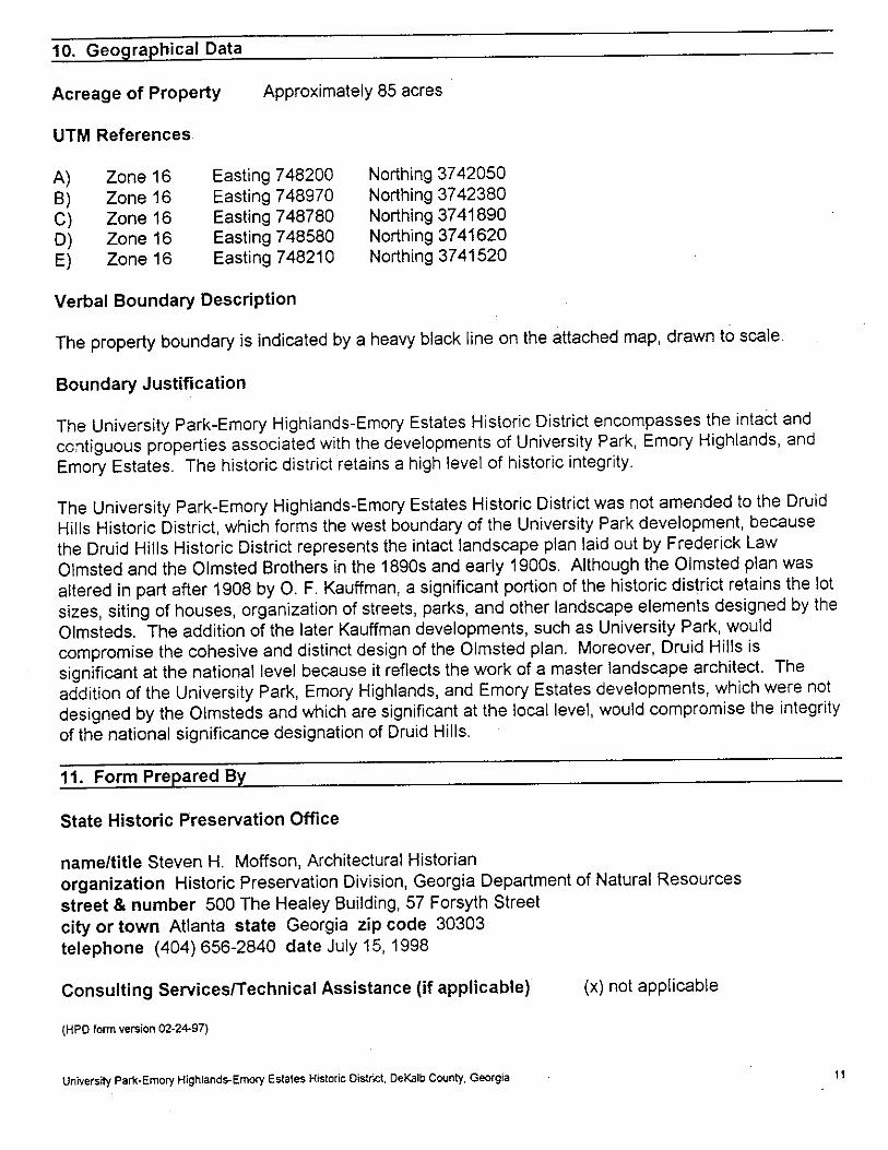
10. Geographical Data
Acreage of Property Approximately 85 acres
UTM References.
A) Zone 16 Easting 748200 Northing 3742050B) Zone 16 Easting 748970 Northing 3742380C) Zone 16 Easting 748780 Northing 3741890D) Zone 16 Easting 748580 Northing 3741620E) Zone 16 Easting 748210 Northing 3741520
Verbal Boundary Description
The property boundary is indicated by a heavy black line on the attached map, drawn to scale.
Boundary Justification
The University Park-Emory Highlands-Emory Estates Historic District encompasses the intact andcontiguous properties associated with the developments of University Park, Emory Highlands, and
Emory Estates. The historic district retains a high level of historic integrity.
The University Park-Emory Highlands-Emory Estates Historic District was not amended to the Druid
Hills Historic District, which forms the west boundary of the University Park development, because
the Druid Hills Historic District represents the intact landscape plan laid out by Frederick Law
Olmsted and the Olmsted Brothers in the 1890s and early 1900s. Although the Olmsted plan was
altered in part after 1908 by 0. F. Kauffman, a significant portion of the historic district retains the lot
sizes, siting of houses, organization of streets, parks, and other landscape elements designed by the
Olmsteds. The addition of the later Kauffman developments, such as University Park, wouldcompromise the cohesive and distinct design of the Olmsted plan. Moreover, Druid Hills issignificant at the national level because it reflects the work of a master landscape architect. The
addition of the University Park, Emory Highlands, and Emory Estates developments, which were not
designed by the Qlmsteds and which are significant at the local level, would compromise the integrity
of the national significance designation of Druid Hills.
11. Form Prepared By
State Historic Preservation Office
name/title Steven H. Moffson, Architectural Historianorganization Historic Preservation Division, Georgia Department of Natural Resourcesstreet & number 500 The Healey Building, 57 Forsyth Streetcity or town Atlanta state Georgia zip code 30303telephone (404) 656-2840 date July 15, 1998
Consulting Services/Technical Assistance (if applicable) (x) not applicable
(HPD form version 02-2497)
university Park-Emory Highlands-Emory Estates Historic District, DeKaib County. Georgia 11

OM6Appwve~ No. 1024-0316NPS Form 10-9CC-a
United States Department of the InteriorNational Parl Service
National Register of Historic PlacesContinuation Sheet
Photographs
Name of Property:City or Vicinity:County:State:Photographer:Negative Filed:Date Photographed:
Description of Photograph(s):
1. North Decatur Road, photographer facing southwest.
2. Emory Drive, photographer facing northeast.
3. Emory Drive, photographer facing northwest.
4. Emory Drive, photographer facing northwest.
5. Emory Drive, photographer facing south.
6. Ridgewood Drive, photographer facing northeast.
7. Vickers Drive, photographer facing northwest.
8. Ridgewood Drive, photographer facing west.
9. Ridgewood Drive, photographer facing southwest.
10. Burlington Road, photographer facing northwest.
11. Burlington Road, photographer facing northwest.
12. Burlington Road, photographer facing north.
13. Burlington Road, photographer facing northwest.
14. Ridgewood Drive, photographer facing southwest.
15. Ridgewood Drive, photographer facing north.
University Park-Emory Highlands-Emory Estates Historic DistrictDecatur vicinityDeKaIbGeorgiaJames R. LockhartGeorgia Department of Natural ResourcesMarch 1997
University Parl<-Ernory Highlands-Emory Estates Histocic District. Dekaib county, Georgia 12

NPS Form 1O-~-a 0MB Approved No. 1O24-~I8
United States Department of the InteriorNational Park Service
National Register of Historic PlacesContinuation Sheet
Photographs
16. Ridgewood Drive, photographer facing southwest.
17. Emory Circle, photographer facing northwest.
18. Emory Circle, photographer facing northwest.
19. North Decatur Road, photographer facing west.
20. Durand Drive, photographer facing northwest.
21. Durand Drive, photographer facing northwest.
22. Durand Drive, photographer facing northeast.
23. Durand Drive, photographer facing northwest.
24. Durand Drive, photographer facing northeast.
University Park-Emory Highlands-Emory Estates Historic District, DeKalb County, Georgia . 13

.w.. .l•.
__4 ~‘fl. • ~~ ~ •• I I — I o
~tjr 4~J7” ~S ‘~Jf ‘EMORY , QRIL/E
~~~~ L _
~j\~
/ /‘~/,6/-~:i~
~h -
~
~_N1
~‘ _z::i~9u] ~7

C>
aD,
~1
~1.o
CCD7;-
0~
C-,0C
C,CD0•~1
00
L —
aaanai ~a Ian
P.
CD~1(a
~~1
rn0
00
0-C?ri-IB0
rnf-n
CD(a
WV
r—1
—— .2 ~t~t.-’ ~
~~_______ ___
~ q4.n~T~ 1I&
\‘
I .• -- \~ ‘~-r~
- - c---~r. -;/‘
. (
~,A.,4~ !;tZ .-
. ;i- ~4- i I~‘
4 d~@4? ~
1 .1 ®I
~4 I
• )t .
. •~e~ / Øs• . rm- I
~ © I I ‘1
-• I. ‘~ I?I ~
0tz-—’~—-i I
_•~~_~_~t7 —-
~ ~~2!L~ ~1 I - -
I H1
r - - —
V i I
13300

I
I
9
‘-4
C
U
U
I--.0
Q.U
S
-ç
0
I-)
a.- -
0
cj
.,~ 0I’
-‘p
_j~ .‘
ii
‘I
- -. — t
Th
ft~
0)
0-1
0
q
0J
41‘.4
0
—I
2~
-~ ~I • -_. ~4.#.’nq~.~.,*o
/‘‘Y’~~ we’-~c,,..—.;.’
S31V153 .caons
- It~fl’r
__-, ~1~V~ —~--—-J -• •‘~.
P
-.4---
I,
Ii
C
I;
6.
I-—
--I
h--~--—-a ,i•,—.j--I -
‘Sr
:0
S ‘7 -
I-S-I -.
V I.!
0~7
C,,
• 4
I,
4.
‘‘-Ca • ‘I,
I a’’ -4.
a -~
3.
7;
L. .1’ -lr‘S
‘SI.
ii”
© -----44:C,
—I
I
‘I
-~ ~
a’
C
‘.3
‘C’ —---— -
- “44-f’..-.
-A
-4
---1
C.-J
- ---
~~~1 -‘--
n~ .ma~_ Tnt.
____ ___
~~- - ,, -,~- ‘~ - —
- —-~~-‘:r~rt~’ts
_~fl r~’fl~4.’~t-t,-’y,n,t.,tC-c0 ‘4--’—-. t.:.~.,s,;,or. n-r- -,? ~, r;~ *t.r~,..-,- -- - -.
C’)‘C
(5~
C)‘CC-3
I
IIaoC~o
<C

National Register of Historic Places t