Embed Size (px)
Citation preview

F:\Documents\Earth Science\Dynamic Crust\Dynamic Crust Notes.doc 1
Vocabulary
I.
I. Evidence of Crustal Changes A. Deformed Rock Structure - Sedimentary strata normally form in a _______________
___________________. Any change from the horizontal position is evidence of
_____________________________________________________________________.
1. Strata 2. Strata
3. Strata
Unit 4: Dynamic Crust – Earthquakes, Volcanoes & Earth’s Interior
Anticline Asthenosphere Compression Continental Crust Continental drift Convection Cell Convergent Boundary Crust Crustal plate Divergent Boundary Earthquake
Epicenter Fault Focus Fold Fracture Hot spots Inner Core Island-arc Lava Lithosphere Long wave or L-wave Magma
Mantle Mid-ocean ridges Moho Discontinuity Oceanic Crust Outer Core Pangaea Plate Tectonics Primary or P-wave Richter scale Ring of Fire Rift Valley
Sea floor spreading Secondary or S-wave Seismic wave Seismograph Shadow zone Subsidence Syncline Subduction Transform Boundary Tsunamis Volcano
F:\Documents\Earth Science\Dynamic Crust\Dynamic Crust Notes.doc 2
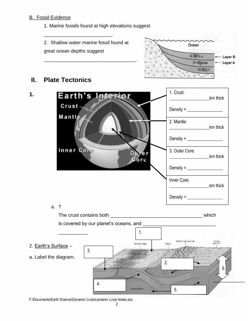
B. Fossil Evidence
1. Marine fossils found at high elevations suggest
_________________________.
2. Shallow water marine fossil found at
great ocean depths suggest
__________________________________.
II. Plate Tectonics
1.
a. T
The crust contains both __________________________________ which
is covered by our planet’s oceans, and ___________________________
_________________ that is the land on which we live.
2. Earth’s Surface – a. Label the diagram.
3.
2.
1.
4.
5.
6.
1. Crust: __________________km thick
Density = ________________
2. Mantle: __________________km thick
Density = ________________
3. Outer Core: __________________km thick
Density = ________________
Inner Core: __________________km thick
Density = ________________

F:\Documents\Earth Science\Dynamic Crust\Dynamic Crust Notes.doc 3
b. Density of: 1. Ocean (water) _______________
2. Granite (continental crust) _______________
3. Basalt (ocean crust) _______________
4. Rigid upper mantle
5. Asthenosphere
c. Lithosphere = __________________ + ____________________________
d. – The plastic-like layer below the lithosphere in the Earth’s upper mantle.
3. Theory of Continental Drift
a. – proposed the theory of Continental Drift in the early 1900’s.
b. He proposed that approximately 200 mya, all the continents existed as one large land mass which
he called _______________________.
Evidence of continental drift:
1. Coastline of the continents – for example, the east coast of _______________________________
fits well with the west coast of _______________________________ – like the pieces of a giant
.
2. Fossil Clues – certain fossils of
___________________________ are found on
widely separated continents.
Mesosaurus was a small freshwater reptile. It’s
fossils are found in and
Glossopteris – it was an ancient seed-fern (with
very large heavy seeds). It’s fossils are found in _________________, India, Australia, Antarctica
and .

F:\Documents\Earth Science\Dynamic Crust\Dynamic Crust Notes.doc 4
3. Rock Clues:
a. The _______________________________ Mountains of the eastern US are geologically similar
to the mountains in Greenland and Western Europe, which include the Caledonian Mountains of
Scotland.
b. Structure, age, and mineral content of rocks are similar on the coasts of eastern
________________ __________________________________________________.
4. Climate Clues:
a. Coal, which forms from plants that grow in warm swampy environments, is found today in the
colder climates of ____________________________________________________.
b. __________________________________, containing the remains of coral, which once lived in
_________________________, is found today in northern latitudes such as .
c. Ancient rocks of the __________________________ near the equator in South America, South
Africa and other southern landmasses show evidence of _______________________________.
4. Theory of Sea Floor Spreading
A. Topography of the ocean floor
Label the following on the diagram.
1. Seamount
2. Abyssal plain
3. Rift-valley
4. Mid-Ocean Ridge
5. Trench
6. Continental Slope
7. Continental Shelf
B. Evidence for Sea Floor Spreading
1. Age Evidence – As the distance from the ocean ridge
the age of the rock
.
2. – magnetic clues
from the iron-bearing basalt rock of the ocean floor supports
the theory of seafloor spreading.
(add the magnetic field arrows to this picture)

F:\Documents\Earth Science\Dynamic Crust\Dynamic Crust Notes.doc 5
C. The Theory of Sea Floor Spreading
1. The Theory of Plate Tectonics states that Earth’s (crust + upper
mantle) is divided into sections called .
Key to Major Plates
1. North American
2. South American
3. Eurasian
4. African
5. Pacific
6. Nazca
7. Antarctic
8. Indian-Australian
2. – The theory of Plate Tectonics states that these
lithospheric plates are in motion and “float” or ride on the _____________________________.
3. Direction of Plate Movement – the movement and interaction of tectonic plates creates 3 types of
plate boundaries: the arrows on the tectonic map below show the relative motion.

F:\Documents\Earth Science\Dynamic Crust\Dynamic Crust Notes.doc 6
4. Types of Plate Boundaries
A. Divergent Plate Boundaries – .
1. _________________: Mid-Atlantic Ridge
2. Continental –
B. Convergent Plate Boundaries –
________________________________________________________.
1. Oceanic-Continental – _____________________________ ________________
Example: Nazca (oceanic) subducts under South American (continental)
2. Oceanic – Oceanic –
______________________________
_______________________ of
Japan and Alleutian Islands (Alaska)
3. _______________________ - _________________________ – Indian/Australian Plate
Colliding with Eurasian Plate forming the
Himalaya Mountains
C. Transform Plate Boundaries –
F:\Documents\Earth Science\Dynamic Crust\Dynamic Crust Notes.doc 7
D. Convection Currents = ___________________________________________________________
Hot, ______________dense material from deep within Earth’s mantle rises. When this material
cools near the surface, it becomes ____________ dense and sinks. The resulting convective flow
of this material in the mantle ___________________ /_______________ lithospheric plates across
the surface of Earth.
III. Earthquakes
A. ______________________________ – the branch of science that studies earthquakes.
B. Causes of Earthquakes – __________________________________________________________
_________________________________________________________________________________.
1. Plate Boundaries
Divergent Boundary -
Convergent Boundary – Ocean –Continent -
Convergent Boundary – Ocean – ocean -
Transform Boundary – (Strike-Slip Fault) -
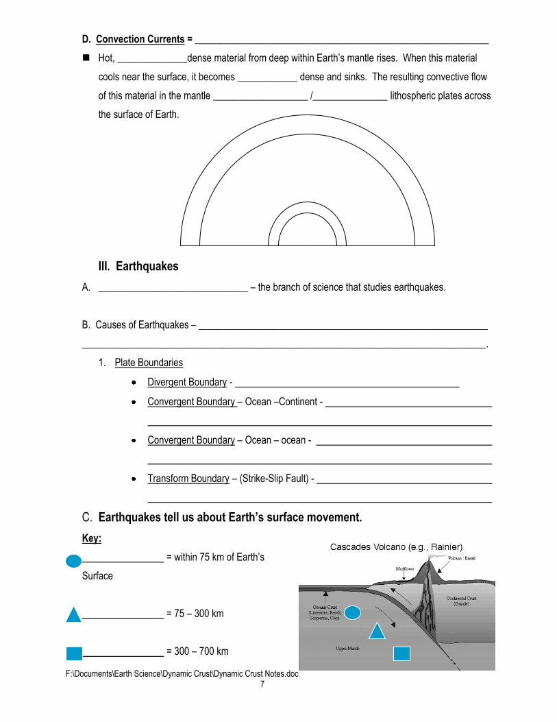
C. Earthquakes tell us about Earth’s surface movement.
Key:
= within 75 km of Earth’s
Surface
= 75 – 300 km
= 300 – 700 km

F:\Documents\Earth Science\Dynamic Crust\Dynamic Crust Notes.doc 8
D. Earthquakes cause other disasters
Tsunami =
Characteristics: Speed =
Height =
Features formed by tectonic activity
1.
Faults
2. Earthquake Waves and Earth’s Interior
a. Origin and map location
___________________ = Point beneath Earth’s surface where fault movement releases seismic
waves (energy)
____________________ = the point on Earth’s surface directly above the focus.
b. Types of seismic waves
1. Analysis of seismic waves (P and S waves) has led scientists to infer the
of Earth.
2. P Waves
P or Primary Waves- Also known as
waves -
Motion of matter due to P waves-
alternate contraction and expansion
of rocks in a direction parallel to the direction of wave propagation.

F:\Documents\Earth Science\Dynamic Crust\Dynamic Crust Notes.doc 9
3. S Waves
S or Secondary Waves- Also known as
Motion of matter due to S waves-
displacement of adjacent rocks in a
direction to the direction of wave propagation.
The velocity of P and S waves is controlled by how the material through which wave is
traveling responds to shear forces. It also depends on the of the
material.
4. L-Waves
_________________ are
___________that cause horizontal
shifting of the Earth during an
________________
C. Seismograph –
D. Locating the Epicenter
Using Seismic Waves to Study Earthquakes
1. Need at least stations
2. Determine when P wave arrives
3. Determine when S wave arrives
4. Difference between S and P wave arrival ( t)
5. Locate on travel-time curve what the ( t) corresponds to in distance
6. Draw circles around each station with radii=distance just determined
7. Intersection of three circles is the epicenter

F:\Documents\Earth Science\Dynamic Crust\Dynamic Crust Notes.doc 10
E. Earthquake Waves
• Seismic Waves travel through the entire Earth
• Travel at different rates through different !
• That’s why the lines “ ”…….when they go through the layers
• Earth’s structure/interior is divided into the crust, mantle, outer core and inner core.
F. Measuring an Earthquake
1. Richter Scale –
.
(Each of the numerical steps represents a 10-fold increase in the amount of energy; for
example, a reading of 3 indicates 10 times more energy than a reading of 2)
Earthquake Severity
Richter Earthquake Magnitudes Effects Less than 3.5 Generally not felt, but recorded. 3.5-5.4 Often felt, but rarely causes damage. Under 6.0 At most slight damage to well-designed buildings. Can cause major damage to poorly constructed buildings over small regions. 6.1-6.9 Can be destructive in areas up to about 100 kilometers across where people live. 7.0-7.9 Major earthquake. Can cause serious damage over larger areas. 8 or greater Great earthquake. Can cause serious damage in areas several hundred kilometers across.
2. Mercalli Scale –

F:\Documents\Earth Science\Dynamic Crust\Dynamic Crust Notes.doc 11
IV. Volcanoes
A. Volcanic
Regions on Earth
Ring of Fire =
B. Causes of Volcanic Activity
1. ____________________ - island arc volcanoes (Aleutians), subduction (Cascades, Andes)
2. Hot Spots –

F:\Documents\Earth Science\Dynamic Crust\Dynamic Crust Notes.doc 12
C. Types of Volcanoes
D. Volcanic Features