Embed Size (px)
Citation preview
I F AS R CT R
Portraits and Paradigmsof Development underSpecial Autonomy in Papua
Edited by I Ngurah Suryawan and Muhammad Azka Fahriza
IFATUTR IOS: Portraits and Paradigm
s of Developm
ent under Special Autonomy in Papua
2020
ISBN 978-623-6001-00-4
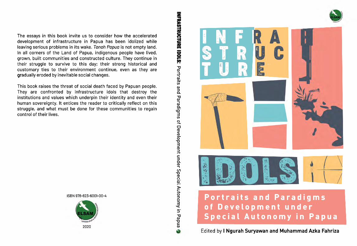
The essays in this book invite us to consider how the accelerated development of infrastructure in Papua has been idolized while leaving serious problems in its wake. Tanah Papua is not empty land. In all corners of the Land of Papua, indigenous people have lived, grown, built communities and constructed culture. They continue in their struggle to survive to this day; their strong historical and customary ties to their environment continue, even as they are grgradually eroded by inevitable social changes.
This book raises the threat of social death faced by Papuan people. They are confronted by infrastructure idols that destroy the institutions and values which underpin their identity and even their human sovereignty. It entices the reader to critically reflect on this struggle, and what must be done for these communities to regain control of their lives.

Infrastructure Idols: Portraits and Paradigms of Development
under Special Autonomy in Papua

Infrastructure Idols: Portraits and Paradigms of Development
under Special Autonomy in Papua
Yason NgeliaYuliana LantipoPilipus Robaha
Yohanis MambrasarWaldine Praxedes Meak
Benny Mawel
Edited by I Ngurah Suryawan and Muhammad Azka Fahriza
Jakarta, 2020
Infrastructure Idols: Portraits and Paradigms of Development under Special Autonomy in Papua
Originally published in Indonesian by ELSAM as Berhala-Berhala Infrastruktur: Potret dan Paradigma Pembangunan Papua di Masa Otsus
Editors:I Ngurah Suryawan dan Muhammad Azka Fahriza
Authors: Yason Ngelia, Yuliana Lantipo, Pilipus Robaha, Yohanis Mambrasar,Waldine Praxedes Meak and Benny Mawel
English Language Editor:Hannah Dwyer Smith
Cover and Content Designer:Sabiq Carebesth and Agus Teriyana
First Printed December 2020978-623-6001-00-4
Lembaga Studi dan advokaSi maSyarakat (eLSam)Jalan Siaga II, No 31, Pejaten Barat,Pasar Minggu, Jakarta Selatan 12510
Telepon : 021-7972662, 021-79192564Faksmili : 021-79192519Surel : [email protected], Laman: www.elsam.or.idTwitter : @elsamnews - @ElsamLibraryFacebook : https://www.facebook.com/elsamjkt
This work is licensed under a Creative Commons Attribution-NonCommercial-NoDerivatives 4.0 International License.
All ELSAM publications are dedicated to the victims of human rights violations, in addition to being part of the effort to promote and protect human rights in Indonesia.
v
Preface
THE JOKOWI ADMINISTRATION has made Papua one of the focal points and main concerns for infrastructure development in Indonesia. Various projects are claimed as concrete efforts to strengthen the economy of the Papuan people. The construction of the Trans-Papua Highway, connecting the provinces of West Papua and Papua and stretching from the city of Sorong in the west to Merauke in the east, is one of the major projects predicted to improve the economy of the Papuan people, narrow income gaps and bring down goods prices in the region.
In addition to infrastructure development, the Jokowi administration has also set out a new framework for Papua’s development, namely the acceleration of human resource development, transformation and economic development, enhancement and preservation of the environment, and bureaucratic reform. This approach seeks to realise a state of advancement, prosperity, peace and dignity for the people of Papua and West Papua Provinces (Presidential Decree No. 20 of 2020).
The plan and orientation of the Government requires significant efforts and steps to be realised. This is especially true of convincing the
vi
Papuan people that these are not just false promises, because the facts show something else. Until now, Papua has remained a less developed region compared to other provinces in Indonesia. In 2019, the Central Statistics Agency (BPS) noted that the Human Development Index (HDI) for Papua ranked the lowest compared to other Indonesian provinces, just 60.84% for Papua Province, followed by West Papua Province with 64.7%. The health tragedy in Asmat in 2018 was not the first; prior to Asmat, other areas have also experienced multiple health tragedies. Year after year, Tanah Papua (or ‘Land of Papua’, as it is known) remains shrouded in tragedy, its citizens stricken by disease and famine.
In practice, development in Tanah Papua, which is expected to create justice and prosperity, and reduce disparities between regions, in fact results in the opposite. The security approach and development paradigm that is oriented towards the exploitation of natural and extractive resources has produced devastation for Papua’s lands and forests. Plantation investments and development projects have destroyed Papua’s virgin forests, turning them into industrial land. Forests, which are considered as the mother by Papuans, protecting nature and the lives of the Papuan people, are slowly disappearing. Development is seen by the Papuan community as an effort to “get rid of land owners and indigenous peoples in various ways, including by force”.
Development also often collides with the values and modes of production that have long been adhered to by indigenous Papuans. A Mbaham-Matta resident who lives along the Trans-Bomberai Road revealed the nature the development process in Papua: “As community members at that time, we were not involved in the process of constructing this road”. A similar situation was conveyed by a Werur resident whose garden was seized for the airport construction; his comment is telling of the speed with which the process of evicting residents’ land had occurred. “When I arrived that afternoon I was angry because they had not talked to me yet, but the construction equipment was already in position.” However, these ‘small’ facts do not seem to be considered a serious problem by the government in Jakarta. They appear to be considered as normal side effects that need not impede the progress
vii
of development. Nevertheless, slowly but surely customary lands that were communally owned and used for the common good of indigenous peoples in Papua are being lost, and in some cases, development is igniting in internal conflicts between tribes.
This book, published by ELSAM, clearly and straightforwardly describes the localised, yet not insignificant, impacts of development processes. If allowed to continue, they will not remain a ‘Papuan issue’, but will become an Indonesian issue, perhaps even an international one. In this book, young Papuan researchers have succeeded in picturing and reading the facts and interests behind the development processes taking place in their region. Through their diverse backgrounds and perspectives, the authors were able to identify substantial issues that require an immediate Government response, with wider implications regarding the future orientation of development plans for Papua.
We thank the authors, each of whom took a lot of their time to go into the field and write down their observations carefully and clearly. We also remember one of the intended contributors, Assa Asso, known as Stracky Yally, who was originally involved in this project but was unable to complete his research. After taking photographs documenting an anti-racism demonstration on 29 August 2019, Stracky became a victim of criminalization and had to undergo legal proceedings on charges of treason.
The publication of this book is expected to spark critical awareness among human rights activists, the government and the wider community, to explore issues of human rights, the environment, natural resources and development in Tanah Papua with a clear mind. Together, we can encourage discourse and development efforts that prioritize the values of justice and human rights.
Jakarta, 10 December 2020
Wahyu WagimanExecutive Director, ELSAM

ix
ForewordPapua, Caught in the Snare
of Developmentby Elvira Rumkabu
WHEN HE WAS named President in 1966, Suharto expressed the commitment of his New Order government to carry out Pancasila1 and the 1945 Constitution in a pure and consistent manner. The policy framework of the New Order era also changed from the ‘spirit of revolution’ in the Sukarno era to one of ‘acceleration and modernization’.2 The goal that Suharto was trying to achieve at that time was to integrate Indonesia into the modern capitalist system.
From a modernization perspective, the existence of a certain modern attitude is a prerequisite for development.3 Traditional societies have characteristics such as being bound by traditional norms, living in relative isolation, subsistence, having a strong relationship with nature, being oriented to the past, pursuing non-economic incentives, and
1 Pancasila is the foundational ideology of the Indonesian State and is based on five core principles: the belief in one God, just and civilized humanity, Indonesian unity, democracy, and social justice for the peoples of Indonesia.
2 Oekan S.Abdullah and Dede Mulyanto, Isu-Isu Pembangunan: Pengantar Teoretis, (Jakarta: PT.Gramedia Pustaka Utama, 2019).
3 Ibid, p. 21.
x
desiring to maintain the stability of life as if it were static.4 Therefore there is a need to modernize not only the individual character, but also the institutions and social structures within them, to achieve the standard of being modern.
In Papua, a mantra of modernization underlies the transmigration policy5 since the 1960s. This migration of populations from Java and Bali was followed by changes in the social and cultural fabric of Papua. The Papuan people were forced to abandon their staple foods and switch to planting rice, thus changing the local agricultural system. Likewise, the traditional languages of Papua were no longer used, because transmigrants could only speak Indonesian; even though Papua has more than 200 indigenous languages, Indonesian is the only language spoken universally. Not surprisingly, local residents now have better Indonesian language skills than the incoming migrants. Even in formal institutions, local languages are not allowed to be taught.6 This homogenization policy was implemented through strong political and military control, making it difficult for Papuan people to resist.
One form of cultural violence in the name of development was the so-called Operation Koteka, which took place between April and June 1977.7 For the sake of modernization, the government poured out IDR 205 million to force the replacement of koteka8 with shorts.9 The value of ‘civilizing’ the Papuans was imposed through military campaigns by
4 Ibid, p. 24.5 A policy of government-mandated internal migration from more densely populated areas of
the archipelago to less populous regions, typically in eastern Indonesia, including the provinces of Papua and West Papua.
6 Bilveer Singh, Papua: Geopolitics and the Quest for Nationhood (London: Transaction Publishers, 2008), p. 99.
7 Al-Araf, Sekuritisasi Papua: Implikasi Pendekatan Keamanan Terhadap Kondisi HAM di Papua (Jakarta: Imparsial, 2011), p. 58.
8 In Dani society, the koteka (or penis gourd) is a traditional form of dress which was previously part of everyday life, and is a marker of cultural identity.
9 Singgih Wiryono, “Masa Kelam Koteka Era Orba, Warga Papua Dirazia dan Dipaksa Pakai Celana Pendek,” Kompas.com, 21 January 2020. https://megapolitan.kompas.com/read/2020/01/22/05350091/masa-kelam-koteka-era-orba-warga-papua-dirazia-dan-dipaksa-pakai-celana
xi
the armed forces and state bureaucracy. The Dani people were forced to leave their culture in order to become educated and integrated into a modern economic system. About 15,000 people gathered to protest. In Tiom, Jayawijaya, about 4,000 residents attacked a government post but their resistance was suppressed by the deployment of the military (RPKAD, now called Kopassus TNI AD) via helicopters.10
The development paradigm implemented by the government has even forced penetration of the bodies and minds of the Papuan people. This approach has been justified because of racist constructions of Papuan culture; Papuan people are considered ‘backward’ and ‘primitive’, their culture deemed in need of replacement by ‘Indonesian culture’ considered more civilized and modern. This humiliation strategy has ensured that Papuans experience an inferiority complex in the process of social change.
To break the cycle of violence in the various development agendas of the New Order era, the government of Susilo Bambang Yudhoyono made a breakthrough in establishing the Papuan Development Acceleration Unit (UP4B) at the end of 2011. In accordance with Presidential Decree No. 65/2011, UP4B was tasked with supporting the implementation of accelerated development of Papua, especially socio-political development, by means of constructive communication between the government and the Papuan people. Within this framework, policies to support the socio-political aims were established, namely programs to improve security, order and stability, especially in areas with potential for conflict.11 Yet in fact, between 2012 and 2014, there were more than 40 incidences of violence. This shows that despite the discourse of development with a welfare approach, there was no change to the security and defence approach taken in Papua. Papua is still seen as a conflict area that needs militarization.
Under the administration of President Joko Widodo, infrastructure-
10 Al-Araf, Sekuritisasi Papua, p. 58.11 Al Araf, et al., Oase Gagasan Papua Bermartabat Waa…Waa…Waa…, (Jakarta : IMPARSIAL,
2017).
xii
oriented welfare development has continued. Various core programs, such as the construction of the Trans-Papua Highway, the revitalization of bridges and airports, electrification, and the establishment of an economic area, are carried out within the framework of social welfare for indigenous Papuans. In the eyes of the government, infrastructure and economic development is a powerful recipe for improving the welfare of indigenous Papuans. However, this book challenges the narrative of successful infrastructure development and leads us to another question: Have there been any changes in the past and present approaches to development? What has development done to the Papuan people? And for broader advocacy needs: What is the ideal of development for indigenous Papuans?
There are at least four important points that we can understand together through this book. First, the five case studies in this book show that there has been no significant change in the development approach from the New Order era until the present day. The top down and paternalistic character of development remains.
Development encapsulates a power dynamic between development agents (government, corporations and military) as determinants of destiny, and indigenous peoples whose destinies are determined. Because development is a political paradigm, the government implements it according to its own imagination and interests. Indigenous peoples are not given the opportunity to determine the development model they desire or need. Racist constructions related to Papuan ‘backwardness’ also contribute to the exclusion of indigenous peoples in setting the development agenda. They are not seen as executors of development, nor as agents in deciding how economic, social and cultural development should be carried out.
Second, through this book we are able to look at the complexity of the problems faced by indigenous peoples behind various infrastructure projects. It cannot be denied that some level of infrastructural development is important in supporting economic growth. However, behind the splendour of large-scale projects arise complex conflicts that should force the government to review its policies. These conflicts
xiii
not only occur between customary owners and the government, but also emerge as horizontal conflicts between customary communities regarding land ownership and management rights.
In this regard, we are made aware that indigenous peoples are faced with a dilemma. On the one hand, the state does not fully recognize the existence and sovereignty of the community over customary territories. On the other hand, indigenous peoples also face internal problems related to recognition among one another, related to the mapping of ownership rights, rights to natural resource management, and unclear conflict resolution processes. As a result, indigenous peoples are faced with a system of infrastructure development that makes them seem unable to resist, while in parallel, communities may experience divisions at junctures when important decisions regarding their fate are made.
Third, this book shows that there is public awareness of the processes and the negative impacts of development on communities’ existence. However, communities also experiences limitations in the infrastructure of justice and public information regarding the steps and strategies they could take to address injustices and claim their rights.
Fourth, we are invited to reflect together on the role of local governments in implementing various infrastructure developments. The various cases in this study indicate the existence of structural injustice that requires the partisanship of local governments to responsively advocate for the interests of indigenous peoples and victims of development. However, local governments appear unresponsive and even cut off from the realities of indigenous peoples. Collective sensitivity from the government is needed to identify community dynamics, detect signs of conflict and find ways to resolve them.
The five case studies described in this book are important reflections of the various struggles of indigenous peoples. This book does not merely capture the complex issues behind various infrastructure development projects, but further sheds light on the oppression of people who have been crushed by the pace of development.
Finally, this book raises the urgent need for a development model that does not marginalize indigenous Papuans, but which provides the
xiv
greatest possible space for them to determine their own economic, social and cultural development. In the author’s opinion, to achieve this we need to revisit and reposition the development agenda in relation to two key aspects: first, with respect for the existence of indigenous peoples, and second, with regard to political and security conflicts in Papua. Thus the choice of development model will consider human aspects, be sensitive to potential conflicts and take into account the interactions between the various facets of development, physical, social and cultural.
Elvira Rumkabu(International Relations Academic,
Faculty of Social and Political Sciences,Cenderawasih University)
xv
IntroductionInfrastructure Idols:
Portraits and paradigms of developmentunder Special Autonomy in Papua
by I Ngurah Suryawan and Muhammad Azka Fahriza
“What did we get from the construction of the airport? We can hear the noise of the planes and see them taking off and landing in our
village, that’s all.” (Johan Songgeni, Chair of the Busami Tribe Customary Council,
Kamanap, 25 August 2019)
“When I arrived that afternoon I was angry because they had not talked to me but the construction equipment was already prepared.”
(Elsa Mayor, Resident, Werur, 17 August 2019)
ON THE AFTERNOON of 19 May 2013, the author learned
a valuable lesson while chatting with four paitua (elders). He had accompanied them to their gardens during his visit to a village in Arguni Bawah District, Kaimana Regency, West Papua. One paitua said that Papuans are not able to manage life; it is the forests that provide Papuans with a livelihood, Papuans cannot manage barren land. One then asked, “How can we manage the forest, if the forest is sold already to those businessmen?”
The four paitua, the author noticed, told stories along the way to the gardens. They had learned from the experiences of their relatives in Aroba, Tofoi, Furwata and Tanah Merah (Bintuni Bay Regency). The forests that stretch between Aroba, Furwata and Arguni Atas Bay have all been cut down by timber and oil palm companies. They no longer have rights over the forest, which provided the source of their livelihood.
xvi
The bitter experience of the elders’ relatives is what makes them wary in protecting their forest, so that it does not become separated from their customary ownership. “Now we don’t easily let go of our forest and land.”
Development, covering all areas of Papua, clearly requires land on which to build physical infrastructure. In addition, another form of development need is for human resources to drive the bureaucracy and companies operating in Papua. Regional expansion has already come here and there, giving rise to new groups of Papuan elites (Suryawan, 2020). The presence of development initiatives certainly brings new awareness and understanding to the local communities. The meeting of new ideas for development with the lives of local communities has various implications. The perspective of the development program on society, meets the perspective of the community in witnessing development.
Observing in more depth, the perspective of development instilled by the New Order regime is one of a desired and needed change, so that whatever does not change or is old fashioned is automatically considered as ‘backwardness’. Most important among what is considered backward is culture, by which is meant the totality of life practices and values of local communities, and which is seen as a barrier to the development process.
As we hear the roar of heavy machinery tearing through the forests of the indigenous clans in Papua, we may come appreciate that development is often enforced as a new awareness that is present and accepted, separate from the culture of local communities. Development introduced by the state, investors and capital regimes, penetrates the consciousness of the local community, not as a synthesis of the historical process of local cultures, but through the allure of the successful image of development in advanced industrialized countries, supported by the power of capital. Gradually but surely, the displacement of traditional society is not merely a matter of loss of the authentic traditional cultures of the local community, but also a loss of personality and self-confidence, of the local community but also of Indonesian society more broadly (Laksono 2002: 383-384).
xvii
The essays in this book invite us to realise that the accelerating pace of infrastructure development in Papua has left serious problems in its path. Not one inch of soil in The Land of the Bird of Paradise is without an owner. Local, indigenous communities that exist in all corners of Tanah Papua (the Land of Papua) have lived and grown, created communities, constructed cultures, and of course, continued in the struggle to survive until the present day. They have knowledge, experience and historical ties that are strong and proven, even though they are also gradually eroding and stretching along with inevitable social changes. Their relationship to the environment, to their ancestors, and to cosmology are formed from the totality of this knowledge. It is this foundation which is now experiencing challenges and change.
New faces in the form of investment, bureaucratic institutions, and various infrastructure programs, are coming to the villages of Papua. These faces of modernity have no historical connection to their territory. Unfortunately, on the authority of the state, they have claimed the land and resources of Papuan villages as theirs. In this book we will be brought to understand fragments of the collision of the imagination of development — driven through infrastructure — with the imaginations of local communities who remain anxious about their fate after the development takes place. In this context, various dynamics in the form of deception, conflicts, underhanded tactics and false promises, overlap and co-exist.
This book contains five essays by young Papuans from various professions that portray the impact of infrastructure development in their respective work or research areas. We witness how local communities have to struggle against infrastructure developments present in their homelands. The cases relate to the following projects: Stevanus Rumbewas Airport in Kamanap, Yapen; Werur Airport in Tambrauw; the ring road and Youtefa Bridge in Jayapura; Palapa Ring in Wamena; and the Trans Bomberai Road in Fakfak. Each is an example of the impact of infrastructure projects present throughout Papua.
xviii
Fetish of InfrastructureThe anthropologist Michael T. Taussig (1980) in his study The
Devil and Commodity Fetishism, focussing on South America, argues that the coming of capitalistic thinking has a serious impact on the economic orientation, and thus the lives, of local communities. There is a fundamental difference in the exchange processes that occur in the society’s economy. The praxis of the capitalist economy of exchange is merely the means towards the ultimate goal of seeking profit (if taking the right step) or suffering from loss (if taking the wrong step).
The implication of this capitalistic system is that individualism and personal ambition play a very important role, and are fetishized as idols. It is the idolation of ‘merchandise’ that is greedily exchanged and amassed in a capitalistic system that causes alienation between one person and another, between humanity and their environment, and of course between humanity and their production.
A study conducted by Dove (1985) argues that the peak of change occurs as Indonesia applies the concept of development-oriented economic growth. If we examine the traces of the development paradigm, it was during the New Order era that (forced) development was defined as changes that were desired and needed, and relatedly, anything unchanged came to be considered as ‘backward’. In Papua, people experience how the rich and diverse cultures of various communities are seen as obstacles to the development process.
Thus development is also used as a fetish to transform local communities according to the desires of power. The introduction of development leads to a new awareness that is present and accepted, yet exists apart from the culture of the local indigenous community, which actually has historical relations with the land and culture that they construct. The presence of development enters local peoples’ consciousness, not as a synthesis of the historical process of the socio-economic and cultural politics of the local communities, but enticed through the glamourised image of development in advanced industrialized countries. Constructed as such, development is certainly not rooted in the people of the local community.
xix
The narratives of development success are built on examples from various countries, which of course differ in many aspects. The success of development in certain countries has also become a new idol, an image the likeness of which is expected to be successfully mirrored in the villages of Papua. Certainly it is not wrong to be successful; the problem is we can only embrace an image of success, rather than achieving it in reality, and in doing so we have let go of our grip on the cultural knowledge that has been built over aeons.
The idols of development that enter the interior of Papua exploit the natural resources of local communities. The condition of degradation of natural resources and local knowledge is always accompanied by an increase in consumerism, which is driven by the charm of the consumer sector, leading to an identity crisis and social disintegration. Local community members may also participate in exploiting or destroying the nature that is their motherland. This condition reflects that the elimination of the traditional society is not merely a loss of ‘authenticity’ in local culture, but also reflects a of loss of personality and self-confidence among indigenous communities and our society more widely.
The idols of development in the face of infrastructure show clearly how dependent we are on a process whose power is beyond our control. It is at this point that the state and government (both national and regional) seem to become fixated and lose their dynamism. The need for the participation of fellow citizens as partners in carrying out development is often considered irrelevant. The natural environment and local communities are then solely regarded as a frontier to be conquered, not as partners in the evolving history of civilization. The desire for progress itself requires new spaces to develop.
Rachman (2015: 41-42) identifies the expansion of the capitalist production system as requiring special “spatial reorganization” so that capitalistic production can expand geographically. What is meant in this spatial reorganization is as follows: first, a space for imagination and description, including technocratic design, wherein we find the terminologies of ‘master plan’ and ‘grand design’; second, the material
xx
space in which we live; and third, the spatial practices of various parties in making space, utilizing space, modifying space, and eliminating space, in the context of efforts to meet various needs, including of those in positions as part of the state, corporations, or the people.
Fetishizing development through the image of successfully realised infrastructure projects clearly requires spatial reorganization. It is at this moment that transnational companies dare to invest heavily with the aim of exploiting space, and thus natural resources. Commodities or merchandise under the capitalist system are transported from where they are produced, to be traded and consumed by the people, both to meet living needs and to serve shopping habits (consumptive culture). Infrastructure development with a capitalistic style expands its working area through violent operations, especially through seizing people’s lands and limiting people’s enjoyment - or even prohibiting the use outright - of their land and natural resources. This results in drastic and dramatic changes to the existing land use, and creates groups of workers who voluntarily or involuntarily are conditioned to become the driving force for the continued operation of this capitalistic system.
A study conducted by The Asia Foundation and LIPI (2019: 20-21) looks specifically at the impacts of infrastructure, and particularly of roads, on indigenous Papuans (OAPs). Fetishizing infrastructure has the surface-level impact of opening up greater access for OAPs to the market, increasing their social mobility, access to goods and economic opportunities. Inevitably however, infrastructure, in this case roads, also facilitates access to the forest for others, damaging the careful balance of ecosystems, and increasing inequality and conflict between indigenous and migrant groups. Vulnerabilities in OAPs’ livelihoods, traditions and culture are increasingly widening due to the presence of infrastructure development. The idol of the infrastructure paradigm that prioritizes the interests of economic growth fails to pay attention to the sustainability of local community life (Porath, 2002; Adam et al, 2011; Menezes and Ruwanpura, 2017; The Asia Foundation and LIPI, 2019)
The idol of the infrastructure paradigm that has been carried out in Papua until the present day is oriented towards building connective
xxi
infrastructure that links centres of economic growth. This paradigm is part of an economic development strategy for poverty reduction through the development of superior commodities in the plantation and mining sectors. In line with this is the development of special economic zones, openness and a system of regulations that invite maximum investment.
Instead, central and local governments need to focus firmly on the direction of infrastructure development in Papua to strengthen OAP access to health, education and their desired livelihoods. This clearly needs to be a top priority, and is one that has the potential to reduce inequality between regions and support sustainable development in Papua. Infrastructure in this model is designed with communities, not commodities, in mind.
Criticism of this paradigm of infrastructure idolatry notes how it succeeds in forgetting the remote communities who in fact live on the ancestral lands which are targeted by such campaigns. Instead, we demand a shift in focus, wherein the sustainability of the life of OAP communities living in the interior of Papua is prioritised. Focusing on improving access between OAP villages and high quality providers of healthcare and education is one example (The Asia Foundation and LIPI, 2019).
The essays in this book guide us to reflect on how to treat the environment and our neighbours. The situation is getting more complicated and multifaceted with the rise of contested interests. It opens the question of where the social movement should begin. The author sees that in moments like this, it is important to link the imagination of social change that is dreamed of by the local communities, with the movement for change initiatives within oneself. This is very important to foster the communities’ self-confidence to survive and struggle amid the roar of social change that is slowly but surely engulfing their lives.
Socio-cultural transformation forces the community to take a position or form a response in relation to the situation that has sparked the change. Under these conditions, efforts are needed to mediate the independence and imagination of the community, and to ensure meaningful engagement with the social changes that occur in their
xxii
environment. The community is involved not only as an observer to the change around them, but as a subject that can determine the direction of change, especially that which they themselves desire. The author believes that the movement of change within oneself is vital in the midst of the chaos of idols that have come to fill our lives and imaginations.
Where is ‘the People’?As Susanto SJ (2003: 8) reminds us, we are expected to be aware and
familiar with the infrastructure development regime, one that often borrows from the stability paradigm of ‘security and order’, as well as attempting to pit Papuan communities against one another through strategies of power co-optation. Papuans live amid various situations of economic and socio-political injustice, societal division and a political culture of kickbacks. Such conditions entrap them in pragmatism, as well as conditioning them to be capable of making ‘additional moves’, a term that indicates a readiness to take advantage of an already bad situation.
‘Additional movement’ also refers to the ability to develop schemes in response to the arrogance of those in power in their behaviour towards Papua. There should be a new awareness of ‘trusting not to trust’ the regime in power, with its persuasion and oppression towards the people of Papua. Such trusting not to trust in the regime is something that can be well comprehended when one considers the invariable inconsistencies in the behaviour of state apparatus towards Papua, that Papuans have come to expect.
The Papuan people who struggle against the grip of a regime fetishizing infrastructure in their lands are teachers to all of us when it comes to the question of how to speak out. Violence, cruelty, injustice and violations of human rights are more often related to the silence of survivors, than to the suspicion or greed of other parties. That is why it is imperative to break the silence and create social movements. The Papuan people who can seize their agency find that they have strong cultural and socio-political capital to achieve this.
Many Papuans are living in relentless violence and suffering. Yet the
xxiii
idol of development has also created Papuans who are opportunistic, egotistical and willing to harm other Papuans for their own advancement. Nevertheless, one of the shared historical experiences of Papua is that of violence and suffering (memoria passionis). This can be used as a foundation to unite the imagination and solidarity of Papuan people towards ‘liberation’ from perpetual vicious circles of injustice and violence. The legacy of being constantly labelled as stupid, lacking in ability, or drunk, is an experience which remains until now despite many changes in various fields. However, discriminatory and colonialist perspectives still cannot be totally erased from the mind of the Indonesian nation and state.
The traumatic experiences of the Papuan people also occur as a result of various forms of violence and human rights violations. The violent experience of the Papuan people is kept in their collective memory, living through the ages and passed from one generation to the next. This experience is inherently degrading to human dignity in general, and to the dignity of the Papuan people in particular. The Papuan experience of violence and suffering has of course plunged Papuans into hatred and sadness. These experiences are very difficult to erase from their collective memory and go on to affect their self-understanding, which in turn threatens to destroy their future (Giay, 2000: 56-57).
For this reason, it is important to explore how the Papuan people see themselves based on social, political, economic and cultural experiences. Often, studies of a community only make observations from an outside perspective, so that they never fully recognize the imagination and experiences of local communities in terms of geographical, political, economic, socio-cultural and cosmological facets. For example, for people living on islands, maritime peoples and fisherfolk, the seas are actually bridges, rather than barriers, in their daily lives. Boating is an activity that shapes the discourse of people who live in the sea, about the islands, beaches, seas, corals, fish and others.
Another reality that threatens the Papuan people in the villages is addiction to the cash incentives that accompany infrastructure development programs. These “empowerment” programs enter the
xxiv
villages and have a serious impact on people’s lives. Such cash fund programs help to facilitate the smooth running of various infrastructure construction projects, even when they bear little value to the local people and are subsequently not widely used. While these objects signify the success of development, behind it all the negative impacts remain. One of the most important impacts is the monetization of rural areas. The paradigm of the monetization of villages starts from the argument that a free market system and a liberal political conception based on a monetary system will solve the problem of poverty. Money in the form of cash aid is considered as the only solution. Another no less serious impact is the weakening and even the destruction of the independence and power of self-determination of the Papuan people in the villages (Kusumaryati, 2020; Handl and Spronk, 2015).
The reality in Papua shows how the grip of capitalism has reached the villages to the point of becoming unavoidable. What has happened was a consumptive choice to follow the progress provided by capitalism. A clear example is the use of cell phones in Papuan villages, despite the lack of signal, as well as the compulsion among young people to consume alcoholic beverages. These conditions provide an opportunity for the growth and development of the machinery of capitalism in the villages.
The main impetus that shapes and drives the capitalist machine comes from its ability to make people consume goods through new modes of production, new transportation, new markets, and the management of new industrial organizations. Products must always be purchased and people are encouraged to engage as mere consumers. Mechanisms to increase consumption are continually being renewed; indeed the old is replaced and the new is always being created (Rahman, 2015: 33-37).
Manufactured goods that enter Papuan villages come from outside and become a reflection of ‘progress’. The image of progress is carried by transnational companies operating in Papua. For this reason, the companies that are present and operating in Papua cannot be seen as independent, but as part of an expansive global production network. Multinational companies in mining, forestry, agribusiness, manufacturing, housing and tourism, infrastructure and other industries
xxv
work under licenses or permits obtained from authorized public officials. These licenses serve as legal grounds to remove and marginalize agrarian people (farmers, fisherfolk, customary communities who collect forest/marine products and so on) from their land and living space, both for companies that hold the license, as well for as the military/police who work on behalf of the license holders.
Reclaiming LifeGradually, the people of Papua are moving towards social death
when critical awareness and reflection cease. Social death is a concept put forward by Orlando Peterson in his book, Slavery and Social Death (1982), in which he argued that what distinguishes slavery from other dependent relationships in society is that a slave is considered already dead by that society. Further, there is a relationship between social death and genocide.
Social death occurs not only because the subject is considered dead by the surrounding community, but also because the institutions and other elements that support identity are destroyed. In the case of Papua, we see that the things that allow a Papuan to formalize his or her Papuan-ness have been destroyed. Social death only requires that the Papuan people are unable to rebuild their relationship with that which makes them Papuan. Thus, social death kills part of the soul of the Papuan.
Leading Papuans towards social death often begins with a tendency to see and discuss what is lacking in the lives of Papuans. Because Papuans are not educated, Papuans need to be educated. Because Papuans are not healthy, Papuans need health technology. Because Papuans are undressed, Papuans need clothing. Because Papuans have no religion, it is necessary to teach them religion. And above all, because Papuans are ‘primitive’, Papuans are in need of modernising (Ploeg, 2002; Card, 2003; Giay, 2016).
The fragments of the Papuan people which shine through amid the idols of infrastructure that are presented in this book can be a spark to ignite the fight against social death and regain control in life.
xxvi
Independence and dignity are obtained through an attitude which responds to change with the ability to reflect. The intended reflection is to draw lessons from the past and present conditions, and for the future. There is a need for openness and awareness of the fact that there have been many changes that have occurred so far.
The movement to reclaim life through reflection also includes deciding on attitudes in response to the changes that are in sight. This includes making decisions regarding future life, what path will we choose to follow in terms of our values, beliefs and social organization. Reclaiming life is also deciding what change we consider positive because it can support our future development, and what should be rejected because it will harm our welfare, culture, identity and personality (Broek, 1996: 10-11).
Papuan people find themselves to be in a liminal condition, engulfed by rapid change. Such a condition is a difficult one when dealing with static characteristics in a society that is closed to the changes that occur. Indeed these characteristics are highly unfavourable for dealing with such changes. The static situation of Papua’s villages and communities illustrates their ‘defeat’ as well as the difficulty they face in placing themselves in the midst of the change brought on by the current wave of industrialization and exploitation of natural resources that is taking place in Papua. This book, and the narratives contained within it, hopes to spark reflection and foster a critical awareness among the people of Papua to help them to seize control over their shared future.
Kasumasa…
Waaa…Waaa…Waaa…
Denpasar – Jakarta, December 2020 I Ngurah Suryawan and Muhammad Azka Fahriza, Editors
xxvii
References• Adam MC, Kneeshaw D, and Beckley TM. 2011. “Forestry
and road development: direct and indirect impacts from an aboriginal perspective”, Ecology and Society, Vol. 17, No. 1.
• Broek, Theo van den. 1996. Kedudukan Persoalan Timika: Bahan Refleksi. Jayapura: SKP Jayapura Diocese.
• Card, Claudia. 2003. “Genocide and Social Death”, Hypatia 18 Vol.1 (2003): 63-79.
• Dove, Michael. 1985. Peranan Kebudayaan Tradisional Indonesia dalam Modernisasi. Jakarta: Obor.
• Giay, Benny, 2000. Menuju Papua Baru: Beberapa Pokok Pikiran sekitar Emansipasi Orang Papua. Jayapura: Deiyai/Elsham Papua.
• Handl, Melisa and Susan Spronk. 2015. “With Strings Attached.” Jacobin, November 24. https://jacobinmag.com/2015/11/conditional-cash-transfers-cct-latin-america-pink-tide-kirchner-bolsa-familia-lula-poverty.
• Kusumaryati, Veronika. 2020. “Perubahan Sosial di Pedesaan di Tanah Papua” Indoprogress, February 11, 2020. https://indoprogress.com/2020/02/perubahan-sosial-di-pedesaan-di-tanah-papua/.
• Laksono, P.M. 2002. “Tanpa Tanah, Budaya Nir-Papan, Antropologi Antah Berantah” in Lounela, Anu and R. Yando Zakaria (editors). Berebut Tanah: Beberapa Kajian Berperspektif Kampus dan Kampung, Yogyakarta: Insist, Jurnal Antropologi Indonesia dan Karsa.
• Menezes DC and Ruwanpura KN. 2017. “Road and development = environment and energy?”, Progress in Development Studies, Vol. 18, No. 1, pp. 52-65.
• Patterson, Orlando. 1982. Slavery and Social Death: A Comparative Study. Cambridge MA and London: Harvard University Press.
• Ploeg, Anton. 2002. “De Papoea: What’s in a name?”, The Asia Pacific Journal of Anthropology 3 (2002): 75-101.
• Porath N. 2002. “A river, a road, an indigenous people and an
xxviii
entangled landscape in Riau, Indonesia” in Bijdragen tot de Taal, Land en Volkenkunde, On the road: The social impact of new roads in Southeast Asia, Vol. 158, No. 4, pp. 769-779.
• Rahman, Noer Fauzi. 2015. “Memahami Reorganisasi Ruang melalui Perspektif Politik Agraria” in Bhumi, Jurnal Agraria dan Pertanahan Vol. 1, No. 1 (2015).
• Susanto, SJ Budi (ed). 2003. Politik dan postkolonialitas di Indonesia, Seri siasat kebudayaan. Yogyakarta: Kanisius
• Susanto, S.J Budi and A. Made Tony Supriatma. 1998. “Paradoks Demokrasi” in Kekayaan, Agama, dan Kekuasaan: Identitas dan Konflik di Indonesia (Timur) Modern. Yogyakarta: Lembaga Studi Realino and Kanisius.
• Taussig, Michael T. 1980. The Devil and Commodity Fetishism in South America. Chapel Hill: The University of North Carolina Press.
• The Asia Foundation and LIPI. 2019. “Jalan untuk Komunitas: Membangun Infrastruktur Konektivitas Jalan untuk Penghidupan Orang Asli Papua dan Lingkungan Hidup”. Jakarta, March 2019.
xxix
Contents
Preface v...........................................................................................................................Foreword Papua, Caught in the Snare of Developmentby Elvira Rumkabu ix...........................................................................................................................IntroductionInfrastructure Idols: Portraits and paradigms of developmentunder Special Autonomy in Papuaby I Ngurah Suryawan and Muhammad Azka Fahriza xv...........................................................................................................................The Origins of Conflict and Environmental Damage in the Tobati-Enggros and Nafri Villages: A preliminary study on the impact of the construction of the Jayapura Ring Road and Youtefa Bridgeby Yason Ngelia and Yuliana Lantipo 1...........................................................................................................................Flying into Turbulent Weather: A study on the construction of the Stevanus Rumbewas Airport, Kamanap Village, Yapen Islands Regency, Papua Provinceby Pilipus Robaha 21...........................................................................................................................The False Promise of Benefit and the Neglect of the Rights of the Abun Indigenous People: A study on the construction of Werur Airport, Tambrauw Regency, West Papua Provinceby Yohanis Mambrasar 37
xxx
...........................................................................................................................The Hope for Prosperity, the Demands and the Anxietiesof the Mbaham-Matta: A report on the impacts of the Trans-Bomberay Road construction in Fakfak Regencyby Waldine Praxedes Meak 59...........................................................................................................................The World Cup in Exchange for Sacred Land:A case study of the East Palapa Ring towers construction in Kurulu and Itlay Hisage Districts, Jayawijaya Regencyby Benny Mawel 75...........................................................................................................................About the Authors 93
1
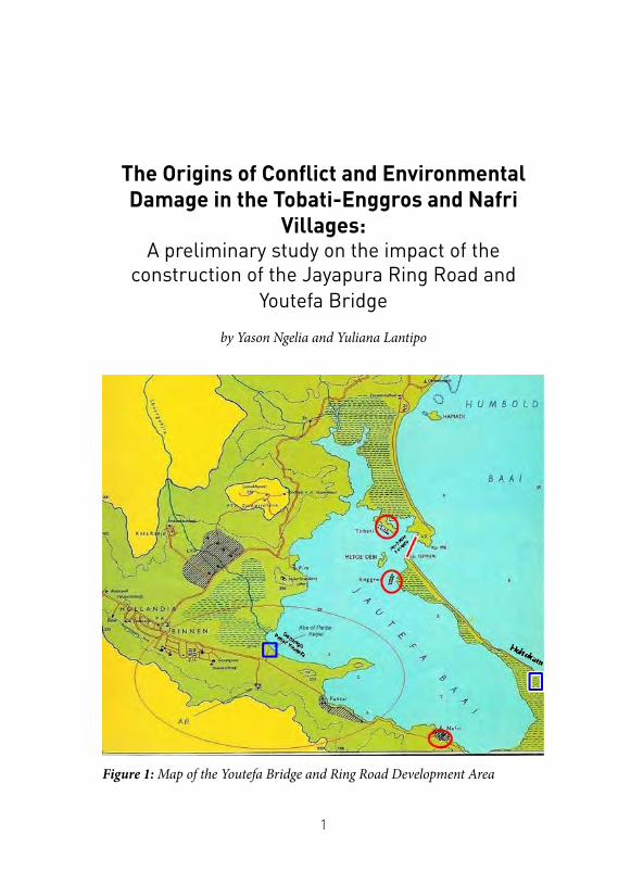
The Origins of Conflict and Environmental Damage in the Tobati-Enggros and Nafri
Villages: A preliminary study on the impact of the
construction of the Jayapura Ring Road and Youtefa Bridge
by Yason Ngelia and Yuliana Lantipo
Figure 1: Map of the Youtefa Bridge and Ring Road Development Area
2
WEDNESDAY, 18 DECEMBER 2019, 1.00 p.m. We are waiting at Youtefa Port, Jayapura, expecting that a passenger boat would come and take us to Enggros Village, a 10-minute trip by speed boat. Thirty minutes pass, but there is no activity of motorists1 at the pier, despite the scores of people milling around – betel nut sellers, women and children, and visitors who come just to enjoy Youtefa Port.
After waiting for a long time, a villager named Abas says that no speed boat will go to Enggros Village until late afternoon, because a member of the Meraudje2 clan has just been buried in the cemetery behind the pier. Usually, only after the funeral service is finished will the motorists take residents back to the village. The team decide to ride by motorbike to Ciberi Beach, passing the ring road and Youtefa Bridge, taking about 15 minutes.
Soon after arriving at Ciberi Beach, we board a boat that has just docked. The boat is not a passenger boat, but the owner offers to carry us to Enggros Village without paying. Normally, the trip would cost IDR 5,000; the fare from Youtefa Port to the same location is usually higher, IDR 10,000. This is because Ciberi is much closer to Enggros, less than three minutes by speed boat.
We are lucky. As we arrive in Enggros Village, wind is blowing, keeping the scorching heat of the sun at bay. Stepping off the boat, we head to the home of a 60-year old woman, a member of Injros Tatj Merry (Enggros Women’s Association) - an organization involving women and girls from various tribes and clans in Enggros Village. Mama, as we call her, is active in the association, working to preserve culture and customs through song and dance. They often hold gatherings to cement the kinship ties between the residents. Our visit to Enggros Village is to hear Mama’s story about the changes in the lives of the Tobati-Enggros people, especially after the construction of the Youtefa Bridge, located in their customary territory.
1 Motorist is a term used by local residents to describe motor boat drivers.2 Meraudje is one of the original clans of Enggros Village.
3
Tobati-Enggros peopleTobati-Enggros3 is the name of the indigenous group that inhabits
part of the Youtefa Bay area. The name also refers to the names of the two villages which are located next to each other, namely Enggros Village and Tobati Village. The villages number among a cluster of 10 villages located along the Youtefa Bay, the majority of which are inhabited by 10 ethnic groups indigenous to Jayapura.
The closest neighbouring village to these two is Nafri Village. All three villages have close kinship relationships formed through inter-clan marriages over several generations. However, among the three, Tobati and Enggros have the closest kinship ties.
People in Enggros regard Tobati as the mother village. Oral histories among the people of Enggros state that the stories and history of Enggros are closely related to the stories and history of Tobati, as Tobati is the parent village of Enggros. Even the name of the village, in the local language, is rooted in the term ‘injros’, meaning ‘second’.
Culturally and traditionally, the two villages also seem inseparable from one another. In their language, people in Tobati refer to father as ai and mother as anyi; not dissimilar to the terms used in Enggros: ace for father and ame for mother. There are even some shared terms in use in both villages, abo tan for grandfather and abo monj for grandmother. Thus it is not surprising the that people in the Youtefa Bay area and its surroundings refer to people from both villages as ‘Tobati-Enggros’ people.
Indeed, the administrative division of the two villages, as stipulated by the government, never really separated the two. The village heads representing the government only perform the administrative affairs of the population and the administrative boundaries splitting the two villages do not reflect the customary areas of each clan, the demarcation of which are supervised by an ondoafi, the highest indigenous leader in each keret or clan.
3 Information about the Tobati-Enggros people is taken from Ohoiwutun (2015).
4
Tobati-Enggros Village, Past and Present Mama was having a nap when we arrived at her house. As we waited,
we observed the activities of the residents; children of the village as well as those from other villages arriving by speed boat. According to one girl, that afternoon there would be a Christmas service conducted by the Children and Youth Congregation of the Abara Christian Church in Enggros.
We waited thirty minutes for Mama to wake up from her nap. She then came to greet us, telling about the modes of transportation used by the Tobati-Enggros people in the past. Before the existence of the bridge and sea taxis,4 Mama said that the Tobati-Enggros people used rowboats to visit people from other villages or islands, and vice versa.
The Tobati-Enggros women, including Mama, are fisherfolk. Other than catching fish in the sea, they also gather bia, or clams, in mangrove forests. Usually, they sell their catch in Youtefa Market. To reach the market, they have to paddle from the village to Fim Beach and then climb to the top of a hill; from there they can finally take public transportation to Youtefa Market. Fim Beach itself is located just below a steep mountain where the Jayapura City Skyline Traffic Police (Polantas) Post is located.
Some Tobati-Enggros people also sell vegetables. They don’t grow the vegetables themselves, but instead buy the produce from the vegetable gardens of the people living in Holtekamp.5 To get to Holtekamp, one has to walk a 25km round-trip along the Youtefa Bay. On the following day, they sell the vegetables in Hamadi Market. They do this three times a week. Apart from fish and vegetables, shellfish is another commodity sold by the Tobati-Enggros, which the women catch in their mangrove forests.
Mangrove forests have a special position in Tobati-Enggros customary law. Elisabeth (2019) explained that mangrove forests have a special name, referring to women’s ownership. Not only that, Tobati-Enggros
4 ‘Sea taxi’ refers to personal sea transportation for hire, such as private boats in Jayapura.5 Holtekamp is a large land area to the east of the islands of Enggros and Tobati
5
customary law stipulates that mangroves are to be managed entirely by women. Men are only allowed to enter the area when it is not being used for the activity of women. Because of their position, mangrove forests are therefore socially important, both as a “safe” sharing space and, more importantly, as an economic resource for women. Unfortunately, according to Mama, only a handful of Tobati-Enggros women now catch bia. They only do so when there are buyers, otherwise, they will enter the mangroves at most once a month to catch this high-protein food.
The Tobati-Enggros people have almost abandoned such gathering as an economic activity, even catching fish and selling vegetables. Today, the people of Tobati-Enggros are no longer dependent on gathered food from hunting, fishing or collecting shellfish in the mangroves as food is available more quickly and easily in traditional markets and stalls.6
This shift has taken place since the Tobati-Enggros found an alternative source of income. The Tobati-Enggros people now depend heavily on beach tourism along the coast from Ciberi to Holtekamp. However, the change in the livelihood of the Tobati-Enggros is not really new. For a long time, the coastline stretching from Ciberi Beach to Holtekamp has been a favoured beach spot for residents of Jayapura and the surrounding area.
Nevertheless, there has been a significant change in recent times, particularly since the Youtefa Bridge was constructed and inaugurated on 28 October 2019. According to Mama, many Tobati-Enggros people are now able to earn daily wages of between IDR 600,000 and 1 million (USD 40-70).7 The huge profits have attracted the attention of all residents who are the customary rights owners along the coast from Ciberi to
6 The situation is different from the research data released by the Rural Community Development Foundation (1990) which describes the livelihoods of Tobati-Enggros residents as extracting sago, gardening, fishing and trade/selling. Sago extraction was noted as the highest proportion, namely 20%. Meanwhile, catching fish in the sea is mostly done by men while shellfish (bia) are caught by women, 55%. Gardening 10%, trading 15%.
7 The rental price of one bench is IDR 100,000. Jubi (Ramah, 18 November 2019) stated something similar to what Mama said. In this coverage it was even stated that the two main informants were happy with the opening of road access through Youtefa Bridge, which has a positive impact on their daily income.
6
Holtekamp. A drastic change in the region occurred, as each clan began to fix the boundaries of ‘their’ beach and began to build facilities for tourists, such as seating, toilets, and so on. These efforts are made on the communities’ own initiative; the municipal government of Jayapura has thus far only given attention to the development of Ciberi beach area.
Infrastructure Projects, the Issue of Compensation and the Dispute Between the Tobati-Enggros and the Nafri
The Youtefa Bridge and Jayapura Ring Road are part of what the mainstream media often refers to as President Joko Widodo’s “concern” for Papua. Infrastructure has indeed become one of the main programs of the seventh president of Indonesia, and infrastructure development in Papua has almost always featured in his public speeches on equitable development.
Youtefa Bridge is a 1,328 meter-long bridge, connecting the Hamadi and Holtekamp beaches. The two-lane bridge, with a width of 50 meters, was built by the Papuan Provincial Government. Construction began in 2017 with financial support from the central government.8 The purpose of the construction of the bridge is to speed up travel from Skouw to Jayapura City. Before the construction of the bridge, travel from Skouw Village, Muara Tami District - which borders Papua New Guinea - to the centre of Jayapura City, took up to two and a half hours. Now, the travel time has been reduced to just 60 minutes. In addition, the bridge is part of a ring road construction program in Jayapura City. It connects several economic centres within Jayapura City with communities on the New Guinean border, Koya, Hamadi and the Jayapura docks.
8 According to Detik data (Hamdani, 28 October 2019) compiled from the Ministry of Public Works, the bridge was financed with Sharia Securities (SBSN) issued by the government, as well as from the Papua provincial budget. The details are as follows: the work of the 433-meter main span bridge is worth IDR 946 billion and the 7,410-meter Holtekamp side access IDR 200 billion. The Papua Regional Budget (APBD) provides for the construction of a 210-meter-long approaching bridge worth IDR 400 billion. Meanwhile, the Jayapura City APBD was used for the construction of a 400-meter long Hamadi side access bridge with a value of IDR 35 billion.
7
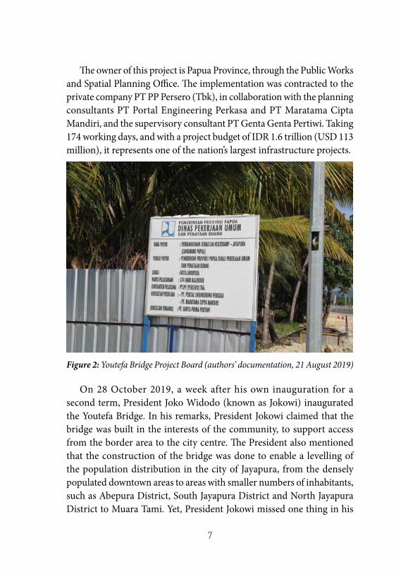
The owner of this project is Papua Province, through the Public Works and Spatial Planning Office. The implementation was contracted to the private company PT PP Persero (Tbk), in collaboration with the planning consultants PT Portal Engineering Perkasa and PT Maratama Cipta Mandiri, and the supervisory consultant PT Genta Genta Pertiwi. Taking 174 working days, and with a project budget of IDR 1.6 trillion (USD 113 million), it represents one of the nation’s largest infrastructure projects.
Figure 2: Youtefa Bridge Project Board (authors’ documentation, 21 August 2019)
On 28 October 2019, a week after his own inauguration for a second term, President Joko Widodo (known as Jokowi) inaugurated the Youtefa Bridge. In his remarks, President Jokowi claimed that the bridge was built in the interests of the community, to support access from the border area to the city centre. The President also mentioned that the construction of the bridge was done to enable a levelling of the population distribution in the city of Jayapura, from the densely populated downtown areas to areas with smaller numbers of inhabitants, such as Abepura District, South Jayapura District and North Jayapura District to Muara Tami. Yet, President Jokowi missed one thing in his
8
speech, namely, the benefits of the bridge for the indigenous people around Youtefa Bay; the Tobati-Enggros.
19 December 2019. We received information that the indigenous people of Tobati-Enggros would hold a traditional ritual of thanksgiving for the construction of the ring road and Youtefa Bridge. The ritual was also held to mark the opening of the two projects. It was said that the traditional Tobati-Enggros rituals must be carried out by traditional officials together with the ondoafi (traditional chiefs) and clan chiefs at dawn. Thus, we arrived at the location at 4.30 a.m.
In a field owned by the Hassor clan, not far from the bridge, a blue tent was decorated with red and white banners, but no one had yet arrived. On the roadside, coconut leaves fluttered from poles, decoration typical for the local community during customary events.
The presence of tents and chairs showed signs that preparations had begun, but they were not yet neatly arranged. After a long wait, at around 7.30 in the morning, several residents appeared, entering the tent. They arranged chairs and fixed decorations (palm leaves and flowers) that had fallen during the last night’s wind.
The opening ceremony was delayed far beyond the typical hours of traditional ceremonies, and contrary to what we were told by the ondoafi of Tobati. According to customary official Yairus Haay, the ceremony was delayed because it coincided with the thanksgiving activity held by the Mayor of Jayapura, Benhur Tomi Mano and his staff (interview, 19 December 2019). According to him, such a ceremony and ritual reading were usually done before sunrise.
At 09.00 a.m., the Regional Leadership Board (Muspida) of Jayapura City, namely the Mayor of Jayapura and the Jayapura City Police Chief, arrived, followed by religious leaders, traditional leaders and Tobati-Enggros community members. Also present were several other traditional leaders, ondoafi and tribal leaders.9 The overall number of
9 These include the chief ondoafi of Tobati-Enggros and ondoafi of Tobati Laut. The tribal chiefs who attended included the chief of the Itaar Tribe from Tobati, the chief of the Itaar Tribe from Enggros, and the chiefs of the following tribes: Meraudje, Habupuk, Mano, Hamadi, Hasor, Drunyi and Dawir.
9
guests was about one hundred.The ceremony began with the blessing of ring road and Youtefa
bridge, conducted at several points marked with palm leaves. The Ondoafi of Tobati, Jhon Ireeuw, said that the traditional ceremony at these points was intended to release the customary territory from the ancestors, through the descendants, so that the area called by the Tobati-Enggros people as safekey is legally released and handed over to the government, to be registered with the National Land Agency (BPN).
After carrying out a traditional blessing at a predetermined point on the ring road bridge, led by Yairus Haay, the customary officials headed right to the middle of Youtefa Bridge. Yairus led a prayer in the local language. The ceremony was conducted solemnly despite the traffic passing nearby. After the ceremony was over, the people and the Muspida returned for the speeches as the final part of the event.
In his closing remarks, Benhur Tomi Mano, the Mayor of Jayapura, stated his appreciation to the indigenous community of Tobati-Enggros, to the ondoafi and other tribal leaders, who had been a part of his struggle for the construction of the bridge, up to Jakarta. He was also grateful to the ondoafi and the community for supporting the city government to fight for the name of this bridge which, as anticipated, was named following the recommendation of the community as Youtefa Bridge.10 At the same time, the Mayor of Jayapura promised to pay attention to and resolve the rights of indigenous land owners properly if he received complaints from the community.
It is not known whether or not Tomi Mano was referring to compensation for the entire area of the construction of the ring road and Youtefa Bridge that the community had complained about. To be sure, the people feel that the Mayor’s promises have not been fully
10 Initially, the bridge was to be named Holtekap-Hamadi Red Bridge of Youtefa Bay, then a suggestion emerged to name it the Papuan Awakening Bridge of Youtefa. There was also a proposal to append Nobadich to the second name, before the fourth proposal was received, the Red-White Bridge of Youtefa. Nevertheless, after going through discussions and even debates with the provincial government, in the end the name Youtefa Bridge was chosen based on the suggestion of the indigenous population of Port Numbay.
10
implemented. The city government has yet to pay compensation for the land used in the construction of Youtefa Bridge.
Protests by the community were even carried out on the day prior to President Jokowi’s inauguration of Youtefa Bridge on 28 October 2019. The protestors blocked the approach to the bridge before being disbanded by troops tasked with securing the area. Following the protest, the Mayor of Jayapura urged the community not to block the road, promising that the payment of compensation to the customary rights owners and the residents of Enggros and Tobati villages would take place after the inauguration.
However, the blockade by the residents on 27 October 2019 did not only stem from the issue of compensation. Beyond that, the residents also demanded the Jayapura City government hold the traditional ceremony on the same day that the bridge was to be inaugurated by the president. The Tobati-Enggros believed that land payments and traditional ceremonies must be carried out immediately to prevent any casualties or loss of life.
Indeed, there were frequent accidents around the ring road and the bridge. According to the Enggros villagers, the accidents were caused by angry ancestral spirits, disappointed as there was no legal release of the land. Two days after the inauguration of the bridge by President Joko Widodo, for example, a young man fell from the bridge to his death (Siagian, 2 November 2019). More than a month later, on 9 December, a middle-aged woman was found dead under the bridge (Redaksi, 9 December 2019).
The residents urged for an end to the accidents, and the traditional ceremony was finally held on 19 December 2019. Still, the ceremony seemed to fail in preventing further accidents, which have continued to occur around the ring road and the bridge well into 2020 (Saiful, 14 October 2019; Rumagit, 21 January 2020). In the view of the Tobati-Enggros, these accidents have been caused by the fact that the government did not fully comply with its promises to the Tobati-Enggros people; they did not receive due compensation for their customary land.
In addition to the issue of compensation sparking protests, the
11
construction of the ring road and Youtefa bridge also sparked conflicts between indigenous residents, specifically between the Tobati-Enggros people and the Sibri clan in Nafri Village. This conflict originated in mutual claims to customary areas where the ring road and Youtefa Bridge were built. The Sibri clan considers the boundary of the Tobati-Enggros customary land to end in Hamadi, and the entire coast of Youtefa Bay from Ciberi to Kali Buaya in Holtekamp to belong to the Sibri. They claim that the two villages (Tobati and Enggros) were floating villages and did not have any customary territory there. They believe that the Tobati-Enggros were permitted to farm and live in the region by the ancestors of the Sibri clan.
Not to be outdone, the Tobati-Enggros denied all the assertions of the Nafri. According to them, the Nafri claims were incorrect, as they have long settled in the Youtefa Bay, from Ciberi to the Crocodile River (in Holtekamp), and farm and find food there. The region has been divided by the Tobati-Enggros community between each clan residing in the village without exception.
The conflicting claims brought the Port Numbay Indigenous Deliberative Council (LMA), the customary organization of eleven villages in Jayapura City, to try and facilitate dialogue between both parties. However, the LMA’s efforts not only failed to find a solution, but in fact led to miscommunication in the community. This was especially true among the Tobati-Enggros, who suspected the Chairman of the Port Numbay LMA, George Awi, of taking sides.
According to George Awi, the suspicion arose because he hailed from Nafri Village. Against this background, the Tobati-Enggros people felt that he behaved unfairly, and supported the Sibri. This resulted in the failure of the mediation process carried out by the LMA. After this, the LMA offered that the meeting be facilitated by the city government, the police and the military (TNI). George Awi remembered the offer, dating from 2016. However, the process also failed to resolve the dispute between residents (interview with George Awi, 14 March 2020).
Their dispute was then referred to the Jayapura High Court. The Tobati-Enggros formed the Team of Seven, chaired by Reverend Willem
12
Itaar, to counter the claims of the Sibri. Unfortunately, the judges of the Jayapura City District Court (Class 1a) decided the case in favour of the Sibri. The Tobati-Enggros appealed the decision (Priyadi, 26 February 2019), as it resulted in the Tobati-Enggros people losing their customary land rights.11
Despite their court defeat, the claim of ownership by the Tobati-Enggros over the land in the Youtefa Gulf region was not without strong historical evidence. Hanggua Rudi Mebri (2010) stated that the Tobati-Enggros people have lived in Tobati and Enggros Villages for four generations.
Research by the Rural Community Development Foundation (1990) also explains the activity of sago extraction carried out by the Tobati-Enggros people in historical terms. According to the research, the Injros (Enggros) people harvested sago in the area around Holtekamp Beach between the Abepura and Kotaraja areas, while the Tobatji (Tobati) people controlled most of the area between Kota Raja and Entrop as their customary land area. The division of this area was strict, because any violations of the customary territory would have triggered conflict or even tribal wars.
Environmental Damage in Youtefa BayApart from igniting the flames of conflict between the Tobati-
Enggros and Sibri peoples, the construction of the ring road and Youtefa Bridge has drastically changed the ecological landscape in the area around Youtefa Bay. The most obvious changes can be seen in the loss of several mangrove forests stemming from the construction of the two infrastructure projects, especially the 36 km-long road from Hamadi, South Jayapura District, at the Youtefa Bridge, to Holtekamp
11 The reason for an appeal made by the people of Tobati-Enggros was stated by Reverend Willem Itaar in the hearings between the Team of Seven and the Muspida of Jayapura City on 25 February 2020. On the same occasion, Rev. Willem also mentioned that the fear of losing land was the strongest motive for the protest which blocked access to Youtefa Bridge at the end of 2019.
13
Koya, Muara Tami District. On the right hand side of the road, only five hectares of mangroves have been replanted.12
The replanting of the mangroves where forests once stood shows how the construction of the ring road and bridge did not take place as planned. The land which has been reforested by the community, with the help of the Jayapura City government, was not the only area lost to development. Near the location of the reforestation area, two other plots have dried up and become neglected, even though they are located right on the coastline. Yet, the function of mangroves on these locations is crucial to preserving the coastline, acting as a barrier to waves. As such, immediate reforestation efforts are needed.
Damage and loss of mangroves not only affects the environment but also the livelihoods of local people. As discussed, mangroves are the habitat of the bia that are regularly consumed by villagers around Youtefa Bay. The environmental damage around Youtefa Bay due to the construction of the bridge and ring road was confirmed by the Mayor of Jayapura.13
However, looking back further, environmental damage in Youtefa Bay has long been anticipated by environmental activists around Jayapura. Before the construction of Youtefa Bridge and the ring road, activists and environmentalists held events and campaigns, warning of the need to preserve the mangrove forests. One campaign highlighted the increasingly worrying problem of plastic pollution in Youtefa Bay. Frederik Wanda, the coordinator and founder of the Port Numbay Green Care Forum (FPPNG) said that their advocacy efforts had been going on since 2009. The work of the FPPNG focuses not only on conducting campaigns and providing social services, they have also planted mangroves at five locations in Youtefa Bay where the mangroves were damaged. The planting is usually done by FPPNG itself, but on several occasions various communities and students also joined. FPPNG has
12 The authors conducted observations and a series of field interviews on 13 and 21 August 2019, and on 13, 18 and 19 December 2019. The findings inform this chapter.
13 The authors recorded the mayor’s statement while attending the thanksgiving ceremony for the construction of the ring road and Youtefa Bridge on 19 December 2019.
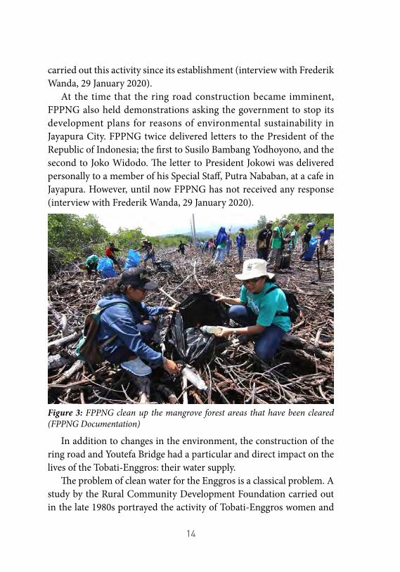
14
carried out this activity since its establishment (interview with Frederik Wanda, 29 January 2020).
At the time that the ring road construction became imminent, FPPNG also held demonstrations asking the government to stop its development plans for reasons of environmental sustainability in Jayapura City. FPPNG twice delivered letters to the President of the Republic of Indonesia; the first to Susilo Bambang Yodhoyono, and the second to Joko Widodo. The letter to President Jokowi was delivered personally to a member of his Special Staff, Putra Nababan, at a cafe in Jayapura. However, until now FPPNG has not received any response (interview with Frederik Wanda, 29 January 2020).
Figure 3: FPPNG clean up the mangrove forest areas that have been cleared (FPPNG Documentation)
In addition to changes in the environment, the construction of the ring road and Youtefa Bridge had a particular and direct impact on the lives of the Tobati-Enggros: their water supply.
The problem of clean water for the Enggros is a classical problem. A study by the Rural Community Development Foundation carried out in the late 1980s portrayed the activity of Tobati-Enggros women and
15
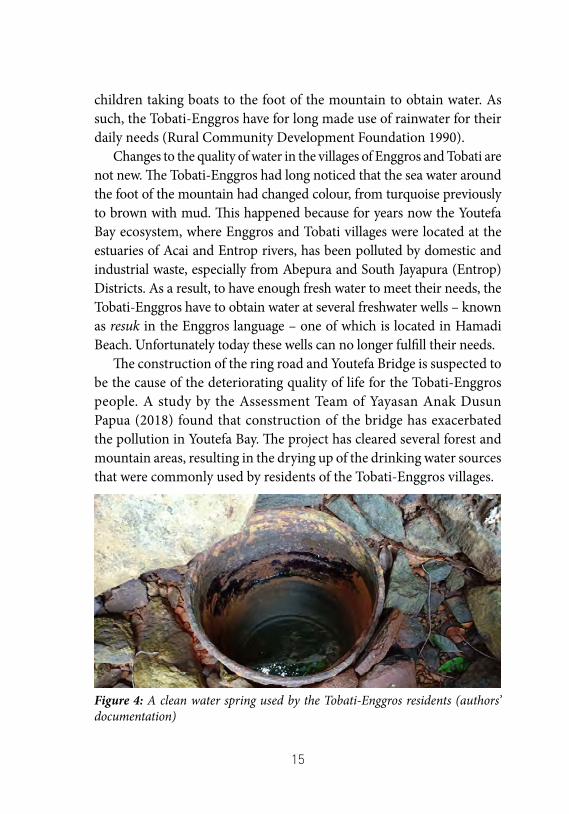
children taking boats to the foot of the mountain to obtain water. As such, the Tobati-Enggros have for long made use of rainwater for their daily needs (Rural Community Development Foundation 1990).
Changes to the quality of water in the villages of Enggros and Tobati are not new. The Tobati-Enggros had long noticed that the sea water around the foot of the mountain had changed colour, from turquoise previously to brown with mud. This happened because for years now the Youtefa Bay ecosystem, where Enggros and Tobati villages were located at the estuaries of Acai and Entrop rivers, has been polluted by domestic and industrial waste, especially from Abepura and South Jayapura (Entrop) Districts. As a result, to have enough fresh water to meet their needs, the Tobati-Enggros have to obtain water at several freshwater wells – known as resuk in the Enggros language – one of which is located in Hamadi Beach. Unfortunately today these wells can no longer fulfill their needs.
The construction of the ring road and Youtefa Bridge is suspected to be the cause of the deteriorating quality of life for the Tobati-Enggros people. A study by the Assessment Team of Yayasan Anak Dusun Papua (2018) found that construction of the bridge has exacerbated the pollution in Youtefa Bay. The project has cleared several forest and mountain areas, resulting in the drying up of the drinking water sources that were commonly used by residents of the Tobati-Enggros villages.
Figure 4: A clean water spring used by the Tobati-Enggros residents (authors’ documentation)
16
Tobati-Enggros residents who met with the authors explained that only two out of five wells in Enggros Village are still functioning. As a result, people have to pay more to make up for the shortfall by subscribing to the Regional Water Company (PDAM) service. Even then, the PDAM is no always able to solve the problem of clean water scarcity, because often water does not flow smoothly and lengthy interruptions to the water supply occur. As a result, the people of Enggros Village have to buy water from sellers. For a 1100-litre tank, they must spend IDR 120,000, which does not include the IDR 100,000 speed boat fare for transporting water to Enggros.
ConclusionMost of the Tobati-Enggros and the eleven other villages in Jayapura
City would never have agreed to building the ring road and Youtefa Bridge in their customary territory. Given the choice, they would have rejected the construction project. Unfortunately, like with many stories of development projects in Indonesia, it seems that indigenous peoples do not have any choice over development plans which are decided at the national level.
The story of the Tobati-Enggros shows how a development project undertaken by the government created conflict, positioning communities in a dilemma and setting them head to head against one another. In the case of the Tobati-Enggros and the Sibri, the conflict has the potential to last a long time. On 9 September 2020, villagers from Tobati-Enggros and Nafri were involved in a violent clash: seven were injured and two cars were damaged (Topikpapua.com, 10 September 2020). This highlights how seeking settlement through the legal system alone is unlikely to resolve the underlying conflict.
In the case of the Tobati-Enggros, the legal settlement process has actually resulted in a negative outcome, the loss of rights to their land. This fact must be swallowed as a bitter pill because the compensation process promised by the government has not been fulfilled. Another aspect that is no less important is that the construction of these two infrastructure projects has led to a deterioration in quality of life for the Tobati-Enggros, as well as for the communities from the eleven other villages.
17
We find that it is the government, inevitably, that is the main actor ultimately responsible for the negative excesses that have affected the Enggros people as a result of the construction of the ring road and Youtefa Bridge. Thus, it is the government who should be held to account, both to fulfil all the promises which were made, and to reverse the negative impacts of the construction, including by reconciling the unending land disputes that they have triggered. Indeed, it is not implausible that the prolonged conflict would lead to a tribal war in Youtefa Gulf between Tobati-Enggros and Nafri villages and action is urgently needed to change the current course.
References• Awi, George. 2020. Interview by Y. Ngelia, and Y. Lantipo. March
14, 2020.• Elisabeth, Asrida. 2019. “Nasib Hutan Perempuan Kampung
Enggros.” Mongabay: Situs Berita Lingkungan, December 22. Accessed September 11, 2020. https://www.mongabay.co.id/2019/12/22/nasib-hutan-perempuan-kampung-enggros/.
• Haay, Yairus. 2019. Interview by Y. Ngelia, and Y. Lantipo. December 19, 2019. Jayapura.
• Hamdani, Trio. 2019. “Diresmikan Jokowi, Ini Sumber Pembiayaan Jembatan Youtefa.” detikcom, October 28. Accessed September 11, 2020. https://finance.detik.com/infrastruktur/d-4762624/diresmikan-jokowi-ini-sumber-pembiayaan-jembatan-youtefa.
• Hanggua, Rudy M. 2010. Injil Di Tanah Tabi 100 Tahun Baptisan Di Metu Debi. Jayapura: Yayasan Emereuw Sentani Papua.
• Priyadi. 2019. “Masyarakat Adat Enggros Lakukan Banding Sengketa Lokasi Jembatan Holtekamp.” Cenderawasih Pos, February 26. Accessed September 11, 2020. https://www.ceposonline.com/2019/02/26/masyarakat-adat-enggros-lakukan-banding-sengketa-lokasi-jembatan-holtekamp/.
• Ramah. 2019. “Pantai C’beery Menjadi Berkah Bagi Warga
18
Kampung.” Jubi.co.id, November 18. Accessed September 11, 2020. https://jubi.co.id/pantai-cbeery-menjadi-berkah-bagi-warga-kampung/.
• Redaksi. 2019. “Kaki Dan Pinggul Patah, Seorang Warga Heram Diduga Terjatuh Dari Jembatan Youtefa.” KabarPapua.co, December 9. Accessed September 11, 2020. https://kabarpapua.co/kaki-dan-pinggul-patah-seorang-warga-heram-diduga-terjatuh-dari-jembatan-youtefa/.
• Rumagit, Alfian. 2020. “Seorang Pelajar Ditemukan Tewas Diduga Korban Tabrak Lari.” ANTARA News Aceh, January 21. Accessed September 11, 2020. https://aceh.antaranews.com/berita/117084/seorang-pelajar-ditemukan-tewas-diduga-korban-tabrak-lari.
• Ruth Miserikodiasdomini Ohoiwutun. 2015. “Kisah Ciptaan Manusia Tabati Dan Penyebaran Suku Itaar Di Tanah Tabi.” In Dongeng Negeri Kita : Antologi Cerita Rakyat Nusantara, edited by Joko Pinurbo, Dhenok Kristianti, and Iman B. Santosa, 1–20. Bekasi: Padasan.
• Siagian, Wilpret. 2019. “Selfie Di Jembatan Youtefa, Respi Jatuh Ke Laut Dan Belum Ditemukan.” detik.com, November 2. Accessed September 11, 2020. https://news.detik.com/berita/d-4769465/selfie-di-jembatan-youtefa-respi-jatuh-ke-laut-dan-belum-ditemukan.
• Syaiful, Achmad. 2019. “1 Pelajar Tewas, 2 Koma Dalam Kecelakaan Maut Di Jalan Ring Road Jayapura-Pospapua.Com.” Pos Papua, October 14. Accessed September 11, 2020. https://pospapua.com/1-pelajar-tewas-2-koma-dalam-kecelakaan-maut-di-jalan-ring-road-jayapura/.
• Tim Assesmen Yayasan Anak Dusun Papua. 2018. “Dampak Migrasi Terhadap Depopulasi dan Pergeseran Budaya Masyarakat Port Numbay.”.
• Topikpapua.com. 2020. “Masalah Batas Tanah Adat, Dua Kampung Di Jayapura Perang, 7 Terluka, 2 Mobil Dirusak.” topikpapua.com, October 9. Accessed September 11, 2020.

19
https://topikpapua.com/masalah-batas-tanah-adat-dua-kampung-di-jayapura-perang-7-terluka-2-mobil-dirusak/.
• Wanda, Frederik. 2020. Interview by Y. Ngelia, and Y. Lantipo. January 29, 2020. Jayapura.
• Yayasan Pengembangan Masyarakat Desa. 1990. “Teluk Youtefa Sumber Kehidupan Penduduk Kampung Injros (Enggros) Dan Tobati Di Jayapura.”.

21
Flying into Turbulent Weather: A study on the construction of the Stevanus Rumbewas Airport, Kamanap Village, Yapen
Islands Regency, Papua Provinceby Pilipus Robaha
“What we got from the construction of the airport? We can hear the noise of the planes and see them take off
and land in our village, that’s all” (Johan Songgeni, Chair of the Busami Tribe Customary Council,
Kamanap, 25 August 2019)
22 AUGUST 2019. Rays of sunshine passing through the afternoon drizzle create a rainbow in Kamanap Village,1 Kosiwo-Yapen Selatan District, Yapen Islands Regency. It is a beautiful sight for anyone exploring the village for the first time. Beautiful, yet lonely at the same time. The rain cloaks everything, including the Stevanus Rumbewas Airport.
The runway measuring 1600 meters by 30 meters is empty. No planes are landing or taking off. Not one airport operations crew can be seen at the airport terminal. Likewise, the kiosks around the terminal are empty. The new airport, owned by the Yapen Islands government, is as if in a trance. All is lonely, all is quiet. It is a quiet which began with the silence
1 In this article ‘Kamanap’ refers to the name of the administrative village, which is located adjacent to Panduami Village, and also to the living space of the Busami Tribe (which consists of three clans: Aisoki Rombe, Songgeni, and Moman) and the two Biak clans who came to Kamanap hundreds of years ago, namely Korwa and Rumbewas. The second definition is used because the writer found that even now the residents of both villages consider themselves “Kamanap people.” This is a remnant of when the two villages were previously considered one administrative area, namely Kamanap Village, before being divided into the villages of Kamanap and Panduami.
22
of the airport proprietors to the public regarding the impact of the airport’s construction, a silence so complete that no public information was ever provided to the community who own the customary rights to the land on which it is built.
Since its inception, the development of the Stevanus Rumbewas Airport has caused controversy among the residents of Kamanap and Panduami Villages, on whose lands the airport was constructed. In addition to the lack of public information, there is an emerging sense that the development of the airport has changed the lives of the people in Kamanap and Panduami Villages, both socially and economically. Before the airport, the people of the two villages felt that their social life was relatively harmonious. Their days were occupied with maintaining their plantations and tending to crops, activities that involve mutual help between residents. They usually sold most of their harvest and kept the rest for personal consumption. Income from selling commodities such as vegetables and cocoa was considered, in the view of most residents, sufficient to bring prosperity into their lives, at least compared that which came after the airport construction.
This report will explore some of the social, cultural, economic and environmental impacts of the Stevanus Rumbewas Airport development on the communities of Kamanap and Panduami Villages, especially for those who have been most directly affected by it.2
Stevanus Rumbewas, the Land of the Busami and the Construction of the Airport
The namesake of the airport, Stevanus Rumbewas, was a leader from Serui, Yapen Islands Regency.3 Stevanus was born in Serui in 1908. He
2 For the purposes of this article, the author carried out field work for a two week period beginning 21 August 2019. The author conducted a series of interviews with actors involved in the response to the construction of Stevanus Rumbewas Airport. The names of the interviewees have been changed for security reasons.
3 Yapen Islands Regency was previously named Yapen-Waropen Regency, formed under Law Number 12 of 1969. In 2002, under Law Number 26 of 2002, Yapen-Waropen Regency was then split into two regencies, namely Yapen-Waropen Regency and Waropen Regency. Following Government Regulation Number 40 of 2008, Yapen-Waropen Regency changed its name again to Yapen Islands Regency.
23
reached the rank of Lieutenant in the Indonesian Navy and in 1969 Stevanus was appointed as a delegate of Yapen Islands (at that time, still a district) to the controversial referendum on self-determination known as the ‘Act of Free Choice’ or ‘Pepera’, in Biak. The referendum, which was orchestrated by the Indonesian military, brought Stevanus Rumbewas to become a leading figure in Yapen Islands.
Stevanus Rumbewas’ role in the Pepera gave him strong influence in the eyes of the community and the Yapen-Waropen Regency Government. This influence allowed him in 1980 to encourage the surrender of lands belonging to the Busami people, one of the indigenous peoples in Yapen Islands, to be used as a transmigration settlement site (Kamanap Airport Land Care Team, 2011). The story of the handover of the land is still remembered well by the people in the area.4 It is on this land, that the Stevanus Rumbewas Airport now stands.
The change in utilization of the land from transmigration settlement to airport began in 1996, two years before the dictator, Suharto, was deposed and the New Order regime came to an end. Dr. Laban Samori, the then Regent of Yapen-Waropen, visited Kamanap Village and held face-to-face meetings with the community. One of the outcomes from the meetings between the regent and the community in 1996, was the change in the function of the land that had been handed over by Stevanus Rumbewas in 1980, and its designation as the location for the airport construction.
The agreement between the indigenous people of Kamanap and Regent Samori in 1996 served as the basis for the Yapen government to cut down the forests and plantations owned by the community in 2000, in order to build a new airport and replace Sudjarwo Tjondronegoro airport. In 2014, Stevanus Rumbewas Airport began operations.
Initially, the airport was intended to serve the Serui-Biak and Serui-Jayapura routes. The goal was to prepare Kamanap Village as one of the potential district capitals, in case the Yapen-Waropen Regency was to be
4 Confirmed by the author during a visit to Kamanap Village, 24 August 2019.
24
split.5 Frans Sanadi, the Deputy Regent of Yapen Islands, who met the author in his office on 3 October 2019, stated that the construction of Kamanap Airport (as it is locally known) was the responsibility of the Yapen Islands Regency. In the future, the government intends for the new airport to replace the old Sudjarwo Tjondronegoro airport, which belongs to the Civil Aviation Office in the regency.
Sudjarwo Tjondronegoro Airport is a legacy from the Dutch colonial era. Its runway measures 650 meters by 20 meters, one of the shortest runways in Indonesia, and can only support Twin Otter or similar aircraft with a passenger capacity of 12. Located in down town Serui, the airport is considered an obstacle to the development of the regency capital. Moreover, in terms of aviation safety, the layout of the airport runway is not in alignment with the direction of the prevailing westerly wind.6 7 This issue also results in irregularities in the landing and take-off schedules of aeroplanes. These are among the reasons why it was considered necessary to construct a new airport in Kamanap Village.
Indigenous/Migrant Sentimentsand the Promise of Compensation
Land ownership status and indigenous/migrant sentiments Papua is not an empty land, states the slogan of the Papuan youth
movement Gempar Papua. This is particularly relevant in the case of the land on which the Kamanap Airport now stands. There are the indigenous people who hold the ownership rights to indigenous lands,
5 Letter from the Regent of Yapen-Waropen to the head of the Kamanap Village customary deliberation council, Number: 5553/479/SET signed by Dr. Philips Wona, Regent of Yapen-Waropen, annexed to the proposal document of the Kamanap Airport Land Care Team (2014).
6 The westerly wind is a strong wind which appears in early October and lasts until the second week of December. Information given by several fishermen who live on the coast of Mariadei-Serui Village.
7 Interview with a local BMKG staff member, 22 December 2019.
25
in this case, the Busami – a community which holds the principles of mutual respect and appreciation, as well as helping one another, as social and cultural norms. It is these norms that, as felt by the Kamanap people, changed drastically after the construction of the airport.
During the author’s visit to Kamanap between late August and early October 2019, many people made the same complaint. They explained how they felt that the togetherness of the Kamanap residents disappeared as the airport was built. In the past, if a family was working on their house, without needing to ask, they would have received help from others, especially their neighbours. The women would help by preparing food and the men with the construction. This would continue until the house was finished. After the airport was built, this tradition became less commonly seen in Kamanap.
It was not only the relationships between residents that became fractured after the airport was built, the position of the tribal chief as the supreme leader in the customary structure shifted as well. In the past, the chief was a respected figure and held a place in all aspects of social relations between residents. Now, everything has changed. One of the most well known incidents that marked this shift in values involved a chief in Kamanap - a teacher in the local church. The chief was attacked with a machete shortly after refusing to sign a note of land release for the keret (clan).8
This incident did not happen out of the blue, though. Since the airport came to Kamanap, a ‘cold war’ has set in between those who have interests cultivating the land that has been demarcated for the airport, and the customary right holders of the land. This cold war began to emerge from the time in 2001 when the Busami community held a deliberation and decided that the Aisoki Rombe clan was the owner of the airport land.9 This decision split the Busami tribe, with two clans advocating that the Aisoki Rombe clan reject the construction of the
8 Interview with informant YS in Kamanap Village, 25 August 2019.9 Formulated by the Care Team (students and community members), in the document from the
Busami community deliberations meeting of 2001.
26
airport, while the two Biak clans, Korwa and Rumbewas, sought to release the land to the government based on their ownership claims.
In order to understand these positions, it is important to trace the history of the presence of the Korwa and Rumbewas clans in Kamanap Village. Biak tribal clans have a long history in Yapen. Albert Rumbekwan (2019) stated that in 1840 a Protestant missionary named von Rosenberg reported an attack in Biak-Noemfoor, which was carried out by a Biak clan against other clans in the Padaido islands. The attack resulted in the near annihilation of the Padaido inhabitants. As a result, most of the remaining population in Miokwundi, a neighbour of Padaido, migrated to Yapen Island.
The history of migration among the Biak tribe dates to long before the attack on Padaido, though. Historian A.B. Lapian argued that this migration was driven by competition and wars between tribes, geographical conditions and culture. Rumbekwan also argues that the long drought which affected the region in the 1400s was a major trigger for the Biak to migrate to the northern coastal regions of Papua, including to Yapen (Wamla, 2016).
In the context of Kamanap Village, it is not known exactly when the two Biak clans arrived, namely the Korwa and the Rumbewas. However, what is clear is that according to the Busami people, the process of assimilation between the Biak and indigenous tribes has occurred for generations, including through intermarriage. Marriage is what has resulted in the Korwa and Rumbewas having the right to manage Busami traditional lands. Thus, for generations, the status of the land management rights of the two clans of the Biak tribe has never been questioned.
It was not until the Kamanap Airport development project began that negative sentiments among the Busami towards the Rumbewas and Korwa clans arose. The land management rights, which for generations were given by the Busami tribe to the Rumbewas and Korwa, came into question. However, this negative sentiment and the challenge to their land rights did not just appear. In 1999, a year before the plan to build Kamanap Airport was realised, the Land Agency (BPN) of Yapen-
27
Waropen Islands Regency conducted a survey of the land around the planned airport location. The land measurement process concluded that the Rumbewas owned 39 hectares of customary land and 27 hectares of certified land (privately owned); the Korwa owned 18 hectares plus 7.75 hectares of land used for the construction of the airport apron, located in the administrative area of the Panduami Village; while the Songgeni clan of the Busami tribe had 8 hectares of land. Additionally, there were 26 persons other than the Rumbewas, Korwa and Songgeni clans with land rights, one of whom was Philips Wona, former regent of Yapen-Waropen, who had a plot measuring 9,940 m² (just less than one hectare).
Immediately the Busami rejected the validity of the data. The data also opened up conflicts between the individual clans of the Busami Tribe, and between Busami clans and the Korwa and Rumbewas clans, as well as between the Korwa and Rumbewas clans themselves. Busami clans accused one another of receiving money in compensation for land. Even the Korwa and Rumbewas clans, who supported the sale of the land, were split by mutual suspicions and accusations of receiving land compensation at the expense of the other. Further, the BPN data split the positions of several traditional leaders of the Songgeni clan.
A member of the Busami tribe told the author that he was often suspected by relatives from his own keret (clan) of skimming from the compensation money paid for the clan’s ancestral lands. When the government paid the compensation in December 2019 and the amount did not correspond with the proposed sum asked by the landowning clan, he was suspected to have taken the missing money. He denied this. “To receive the land compensation money, our father had to write a proposal and it was said that it would be paid in December. But, the payment was not the amount we asked for.”
The dispute between the Busami tribe and the Korwa and Rumbewas clans became evident in the course of two important moments in 2001. On 22 and 23 February 2001, two years after the land survey by the BPN in Kamanap Village, the Busami convened a tribal council. The council, conducted during the Busami Community Deliberations Meeting
28
was meant to respond to social and cultural conflicts arising during the development of Stevanus Rumbewas airport, including conflicts pertaining to claims of customary land rights. The meeting discussed the history of the Busami tribe, the boundaries of land belonging to the clan, the customary rights of the community, the use of land for airport development, and land and crop compensation rights, as well as the process of releasing the Busami tribal land to the government for the airport development.10
In the same year the Kamanap Airport Land Care Team (hereafter ‘the Care Team’) was formed. The team was formed to fight for compensation for material losses including land and crops, as well as non-material losses, namely the social and cultural impacts of the airport construction. However, the Busami Community Deliberations Meeting and the Care Team reached different conclusions regarding airport land ownership rights, reflecting the opposing positions of the two groups.
The Deliberations Meeting resulted in a statement that the land handed over to the government for the construction of the airport was owned by the Aisoki Rombe clan. Thus, all negotiations relating to the construction of Kamanap Airport should go through the Aisoki Rombe clan. More importantly, the Deliberations Meeting agreed the position of the Busami Tribe, rejecting the sale of customary land for the construction of Kamanap Airport. Instead they agreed that if the project were not cancelled, they would demand the government pay rent to the Busami Tribe, through the Aisoki Rombe clan as the customary owners.
The Care Team reached a different position. In their proposal “Settlement of Kamanap-Panduami Airport Land”, it is stated that three clans, namely the Rumbewas and Korwa (both Biak), and the Songgeni clan of the Busami tribe, held the customary rights to the airport land – they did not make any mention of ownership by the Aisoki Rombe, as claimed by the Deliberations Meeting.11 The settlement document
10 Related to the formulation of the Care Team (of students and community members), in the document from the Busami community deliberations meeting of 2001, submitted by YA, one of the traditional elders of the Busami tribe.
11 It is interesting to note that the secretary of the Care Team is one of the traditional leaders of
29
further stipulated a mechanism for the compensation of land and crops, meaning that the Care Team was in a position to agree on the process of selling the land and crops, in opposition to the position of the Busami to reject the project, or at most maintain ownership of the land and lease it.
The unfulfilled promises of compensation and ‘milk money’ In a letter written by the Yapen Regent, Philips Wona, to the
Chairman of the Busami Tribe Customary Council regarding the issue of compensation for land and crops at Kamanap Airport in 2001,12 it was stated that the area of the land allocated for the development of Kamanap Airport would be revised as necessary. The letter went on to note that the the Decree of the Yapen-Waropen Regent No. 113 of 1992 (28 September), was deemed to be no longer in line with developments. The Decree had stipulated that crops would be compensated at different rates, with cocoa trees compensated at a lower rate than non-cocoa crops. This is because cocoa trees were a mainstay commodity and grown on a larger scale than other crops.
In Regent Philips Wona’s 2001 letter, a new compensation approach was outlined which would be implemented by the government through the following measures:
1. Compensate estates/community lands where crops have been destroyed and the land has been used for airport development, calculating the entire investment beginning with land clearing, nursery, planting, fertilizing, maintenance and so on.
2. Provide food assistance in the form of 20 kg of rice for each household for a one-year period.
3. Build clean water facilities in the form of fifteen dug wells; explore the possibility of constructing piped clean water if the available water source is fit for purpose.
the Songgeni clan. The involvement of actors from the Songgeni clan in the Care Team, which from the start has never rejected the development of Kamanap Airport outright, shows the internal conflict within the Busami Tribe. However, it is important to state here that not all members of the Songgeni clan agree with the position of the Care Team.
12 Annexed to the proposal document of the Care Team.
30
4. Providing financial assistance for children of the Busami tribe who are continuing their education at various universities.
Of all the compensation measures promised by the government in Regent Philips Wona’s letter, only the wells had been constructed by the time of the author’s visit at the end of August 2019. Even then, most of them had not been maintained by the community and were out of use. Meanwhile, the promised construction of piped water has not been realised to this day.13
This is not the only unfulfilled promise of compensation, however. Another thorny issue exists regarding the payment of compensation for land and crops, which the Rumbewas and Korwa clans call ‘milk money’.14
In 2014 Stevanus Rumbewas Airport was officially opened by the Minister of Transportation. This event marked the defeat of the Busami people in the fight for their customary rights to the land where the airport is now located. That is, in matters related to compensation, the government only dealt with the Korwa, Rumbewas and Songgeni clans. Here it can be said that the government benefited from not having to pay any rent for the land, as demanded by the Busami.15 Yet, even aside from the rent, it did not make good on its promise regarding compensation.
When interviewed, Deputy Regent Frans Sanadi said that the issue of compensation for the loss of crop revenue and the land itself following the construction of Kamanap airport was under control, and that the government had allocated funds from the Yapen Regency
13 Interview with one of the descendants of Stevanus Rumbewas in Kamanap Village, 25 August 2019.
14 The term ‘milk money’ has a particular significance for Papuan people, describing compensation for land as an entity that not only has a commercial value, but also an intangible value as a manifestation of the Mother. The origin of the phrase is rooted in the value of respect that a man holds for the mother who gave birth, breastfed and raised a daughter that he wishes to marry.
15 Contrary to expectations, the author found no open conflict related to the defeat of the Busami tribe in demanding their customary rights. This situation may be due to the compensation process for the Korwa, Rumbewas, and Songgeni clans being still ongoing at the time the research was conducted in Kamanap Village.
31
regional budget to pay the compensation.16 Yet, this does not reflect the experience of residents. One of the former village heads interviewed by the author said that they, as owners of customary land rights, had demonstrated to demand compensation for land and crops by blocking the entrance to the airport. “Yet until now there has been no response.” 17
The government’s responsibility should have gone beyond what was demanded by the Care Team in 2001. More than that, the government should recognize the rights of the Kamanap people, who are victims of the construction of Stevanus Rumbewas Airport, without exception. Likewise, the government should have known that the Kamanap community, Busami, Korwa and Rumbewas, held hopes that the airport could provide employment for the residents of Kamanap and Panduami Villages.18 Unfortunately, even following the election of a new regent, Tonny Tesar, who was elected in 2012 and is due to end his second term in 2022, the promises of the former regents Laban Samori and Phillips Wona have yet to be fulfilled.
Environmental and Economic ImpactsThe presence of Stevanus Rumbewas Airport has not only caused
noise pollution problems and ignited conflict within the Kamanap and Panduami communities. It has also resulted in environmental destruction through the logging of of mangrove forests, the lumber from which has been used as pillars to support foundations dug at the airport location, before soil hardening and paving processes were carried out. Two private companies, PT. Arta Makmur Permai and CV. Parirap were responsible for cutting down thousands of mangrove trees, each
16 Interview with Frans Sanadi, Deputy Regent of Yapen, 3 October 2019.17 Interview with an informant in Kamanap Village, 28 August 2019. The interviewee is a former
head of Panduami Village and also owned land on which the airport apron was built. 18 Later, after the construction of Kamanap Airport, indigenous peoples in Yapen demanded that
the local government create a regional by-law (perda) to govern the price of land and to protect land value in Yapen. This pre-emptive strategy seeks to avoid the worst case scenario of again of losing their land for no compensation or at a low price when new development projects come.
32
two meters tall, to be used in the foundations of the airstrip. In addition to cutting down the mangroves, forest areas were also cleared, including the rattan within, despite the fact that the community’s economy is dependent on them.19
The airport construction process also tells a further story of environmental damage. The water of Sahorata River, the main source of fresh water to Kamanap, was previously used to meet the daily needs of the community for bathing, drinking and washing. Nowadays, due to pollution run-off from the airport, it can only be used for washing.
Beyond the environmental impacts, the construction of the airport in Kamanap and Panduami villages has displaced the people’s economy, sacrificing residents’ agricultural lands. It was on what is now airport land that farmers used to plant long-term crops such as cacao, rambutan, vanilla, banana, langsat and durian, as well as short-term crops such as string beans, chilli, tomatoes and a variety of other vegetables. This is not to mention the forest plants such as rattan discussed above.
Prior to the construction of the airport, long-term crops, vegetables, and forest products such as rattan, allowed farmers and communities in Kamanap and Panduami to live in prosperity, priding themselves as ‘farmers in suits’. This term, which was used by a number of the residents of Kamanap who spoke to the author, does not refer to the better-known definition of the term, i.e. landowners who employ farm workers to cultivate the land without getting involved in the production process (Rahardi, 1989), but rather to show pride in their welfare before the airport was built.
In the time before the airport, farmers worked all year round tending the fields and gardens, and employed farm workers to carry the harvest during harvest season. From the fruits of their labour, they were able to independently finance their children’s education up to university. Not only that, the farmers were able to keep savings in the bank and buy mopeds and motorcycles on credit, which they could pay each month
19 Rattan is utilized and processed into a number of items of economic value by the local community, such as tables, chairs and various kinds of tableware.
33
from the yields of their crops. Vegetables could be harvested weekly for sale or personal consumption, while long-term crops would be harvested in season (durian, rambutan and langsat) and the yields sold to Biak, Manokwari and Jayapura. Meanwhile, cocoa as the farmers’ main crop could be harvested twice a month and sold to traders in Serui City.
When the airport construction began, these ‘farmers in suits’ lost their agricultural land and plantations. Of course, this eliminated their economic resources and devastated the economy of the workers who worked on the estates. The farmers are now working as lumberjacks, senso lumber carriers, and hunting wild boar in the traditional manner. Although they have found work in new occupations after losing their land, these jobs are more menial and their income as labourers is much less than when they were farmers.
The story of YA, a Busami traditional leader, illustrates the fate of many people who were driven out by the airport and forced to work as labourers because they lost their land. After the airport was completed and started operating, YA worked as a casual employee of the air transportation service stationed at the airport. However, working at the airport does not necessarily mean that his salary meets his daily needs, and YA was lucky to have some land outside the airport location because he is still able to grow some produce and make up for the shortfall in his salary.
Finally, it is necessary to mention how women have also felt the loss of the occupations on which they had previously been dependent. Mama M, a Busami woman, said that on the day her land was cleared for airport development she cried, thinking about the economic future of her family which she had to bear with her husband. In the days before there was an airport in her village, Mama M and her husband worked hard to cultivate the land. From the results of this work, they supported themselves and paid for their children’s tuition fees. So when heavy equipment began to come to her village, and to take over the land her family lived on, a great uneasiness filled Mama M’s mind.
“If the garden is no longer there, then how could Mama help the family
34
economy? In the city, I can work as a domestic helper. But in this village, what can we women do? The garden is gone.”
ConclusionIn any infrastructure development, it is common for the people living
around the project, especially those victimized by the development, to hope the development will improve their economic situation. Such is the case for the residents in Kamanap and Panduami Villages, especially the members of the Busami Tribe. Unfortunately, such expectations are rarely met. In this report, the author has described the unsuccessful attempts of the indigenous Busami Tribe to halt the construction of Stevanus Rumbewas Airport. Their hopes to increase economic income through the airport, especially in Kamanap and Panduami Villages, were not realised. Apart from that, the issue of government compensation for land and crops continues to be a problem like a thorn in the flesh, and keeps threatening to spark conflict. In addition to the resulting impact on the environment and economy, the presence of a conflict-ridden infrastructure development project has had a negative impact on social solidarity more broadly. The community will eventually, inevitably, split. This is more or less what has already happened to the indigenous Busami tribe in responding to the construction of Stevanus Rumbewas Airport.
References• Rahardi, F. 1989. “Ihwal Petani Berdasi.” Majalah Tempo,
September 12. Accessed September 09, 2020. https://majalah.tempo.co/read/kolom/21509/ihwal-petani-berdasi.
• Rumbekwan, Albert. 2019. “Peristiwa-Peristiwa Perang Suku/Tradisional Di Pesisir Utara Papua.” In Prosiding Seminar Hasil Penelitian Pengembangan Ipteks dan Seni, edited by Albert Rumbekwan. V. Jayapura: Lembaga Penelitian dan Pengembangan Masyarakan Universitas Cenderawasih.
• Tim Peduli Tanah Bandara Kamanap. 2011. “Sejarah Singkat Kampung Kamanap Dan Pembangunan Bandara Kamanap:

35
Proposal Tim Peduli Tanah Bandara Kamanap.”.• Wamla, Ibiroma. 2016. “Suku Biak, Suku Vikingnya Papua.”
January 4. Accessed March 20, 2020. https://historia.id/kultur/articles/suku-biak-suku-vikingnya-papua-PMLzX.
• Wardani, Dewasasri M. 2014. “Pelabuhan Dan Bandara Baru Diresmikan - Satu Harapan.” Satu Harapan, December 20. Accessed September 09, 2020. http://www.satuharapan.com/read-detail/read/pelabuhan-dan-bandara-baru-diresmikan.

37
The False Promise of Benefit and the Neglect of the Rights of the Abun Indigenous People:
A study on the construction of Werur Airport, Tambrauw Regency, West Papua Province
by Yohanis Mambrasar
WERUR AIRPORT in Tambrauw Regency is a project of the Tambrauw Regency Government, built under the pretext of accelerating access in order to improve the local economy and benefit the community. With the construction of the airport, residents were promised a change in the level of welfare. The regency government assumes that the presence of Werur Airport will accelerate access to transportation and facilitate the economic activities of residents. It should achieve this by connecting residents in the villages and the capital of Tambrauw Regency, as well as with other cities in West Papua Province such as Sorong and Manokwari. In addition, the regency government believes that the opening of domestic commercial flight routes will absorb potential domestic and international tourists who visit attractions in West Papua, especially Raja Ampat.1
1 The opinion of the Tambrauw Regency Government about the Werur Airport can be read in Hamdani, 21 October 2018.
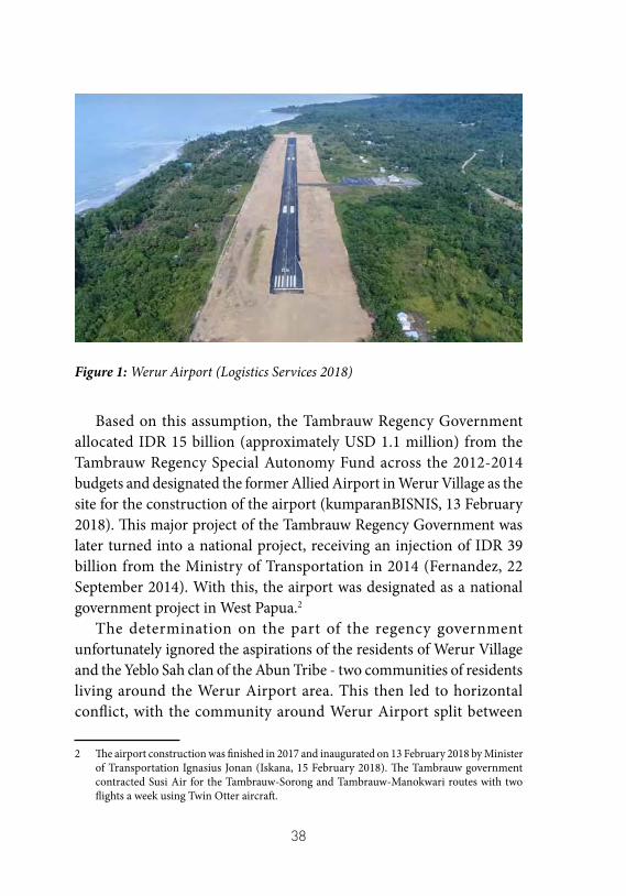
38
Figure 1: Werur Airport (Logistics Services 2018)
Based on this assumption, the Tambrauw Regency Government allocated IDR 15 billion (approximately USD 1.1 million) from the Tambrauw Regency Special Autonomy Fund across the 2012-2014 budgets and designated the former Allied Airport in Werur Village as the site for the construction of the airport (kumparanBISNIS, 13 February 2018). This major project of the Tambrauw Regency Government was later turned into a national project, receiving an injection of IDR 39 billion from the Ministry of Transportation in 2014 (Fernandez, 22 September 2014). With this, the airport was designated as a national government project in West Papua.2
The determination on the part of the regency government unfortunately ignored the aspirations of the residents of Werur Village and the Yeblo Sah clan of the Abun Tribe - two communities of residents living around the Werur Airport area. This then led to horizontal conflict, with the community around Werur Airport split between
2 The airport construction was finished in 2017 and inaugurated on 13 February 2018 by Minister of Transportation Ignasius Jonan (Iskana, 15 February 2018). The Tambrauw government contracted Susi Air for the Tambrauw-Sorong and Tambrauw-Manokwari routes with two flights a week using Twin Otter aircraft.
39
those supporting the project and those opposing it. The government’s approach, which involved only consulting the village elites such as the village head and a few people close to the government, also gave rise to mutual suspicion among the Werur and Abun residents.
In this chapter, the author will unpick the layers of conflict caused by the construction of Werur Airport in Tambrauw Regency. In the second section, the author will explore the roots of conflict, arising from the airport construction. In the third section, the author will elaborate on the demands of the residents who became victims of the airport’s construction, and seek to explain how this has inspired residents’ protests. Finally, there will be a discussion of the findings related to the functions and benefits of Werur Airport for Tambrauw residents in general, providing a broader on background to why the demands of Werur and Abun residents emerged.
Development Without Consent
The Bikar and Abun peoples in Werur Village Werur Village, which is the location of the construction of Werur
Airport, is one of the oldest villages in Tambrauw Regency, West Papua Province. After the division of Tambrauw Regency in 2008, Werur Village was split into five new villages, namely Werur Tambrauw (Wertam), Werwaf, Werur Timur (Wertim), Suyam and Bukit. The airport area intersects with all five of the villages and the perimeter fence directly borders the yards of some residents of the villages. Several residents’ houses have been demolished due to the construction of this airport.
Werur Village was founded in the 1920s and 1930s by people from Biak. The Biak people who founded the village were members of the Biak people in Karon Land,3 and are known today as Bikar, a portmanteau of Biak Karon. The story told among Bikar elders who met with the author,
3 Karon Land is the term used by the indigenous Papuans for all of the area under the administrative boundaries of Tambrauw. The Biak Karon people believe that ‘Karon’ was the term used by their ancestors for the Tambrauw region since their arrival. The term Tambrauw itself only came into use in 2008 with the creation of the regency.
40
is that the Bikar people began to migrate to Karon Land in the late 18th and early 19th centuries. They date the of arrival of the Bikar people to Karon Land in relation to the arrival of the German missionaries Carl Willem Ottow and Johan Gottlod Gleiser to Mansinam Island in 1855. Indeed, according to oral histories the Bikar people occupied the Tambrauw coast even before the Dutch conquered the Tidore Kingdom during the height of Kurabesi’s armada.4 The migration of the Bikar people to Karon Land marked the start of the Biak people living in the area now known as Werur Village.
The people of Werur Village are the second generation of Biak migrants to live in Tambrauw. Prior to the arrival of this generation, Biak people had migrated to and occupied the coastal areas spanning from Tambrauw to the coastal areas of the Moi people (a major tribe in Sorong Regency). They were the first to identify themselves as Biak Karon, or so-called Bikar. At that time, according to the oral history of the Bikar people, not many Abun people (one of the four indigenous Tambrauw tribes)5 lived in this coastal area. One resident interviewed even hypothesized that when the first generation of Bikar arrived in Tambrauw, the Abun people were settled in their hamlets in the Tambrauw mountains. Even so, to this day the Abun people are the recognized owners of the lands along the Tambrauw coast. Werur itself, part of which is the site for the construction of the airport, stands on the communal land of the Yeblo Sah clan of the Abun tribe.
The contact between the Bikar and Abun tribes occurred after Biak people settled in the areas that are known today as villages of Werur and Sausapor. This relationship began when the Biak people began to introduce religion to the Abun tribe. After being nomadic for a long time, far from the reach of outsiders, the Abun began to build their
4 Kurabesi (or ‘Gurabesi’) is another name of Sekmaferi, a Papuan fleet commander from the 15th century. He led a legendary fleet crewed by Papuans. Hailing from Biak, Kurabesi and his fleet sailed to Raja Ampat archipelago and controlled the islands after kicking out the Sawai. Kurabesi was known for his success aiding the Sultan of Tidore in destroying the Jailoloan fleet, resulting in his being wed to the Sultan’s daughter. See Widjojo 2013 for further information.
5 Other indigenous tribes are the Mea, Ireres and Impur.
41
own villages. Nowadays, the closest Abun villages to Werur are Werbes (Werur Besar) and Sausapor. The distance between Werbes and Werur is just 1 km, while Sausapor is more distant, at about 15-20 km.
Despite the long-established relationship between the Bikar people in Werur Village and the Abun people, demographically even today Werur Village is relatively homogeneous. This makes Werur different from surrounding villages, where the populations include fairly large proportions of other Papuan tribes or immigrants. All the sources met by the author claimed that all Werur residents were Bikar.
Nor was this claim one-sided, and the Abun people living in the surrounding villages also confirmed it. To this day, the people around Werur call the village a ‘Bikar village’ - a term not used for any of the other villages. Even so, the author that found some residents of Werur Village were not originally from the Biak tribe. They became inhabitants of the village through marriage, something that seemed to have happened for a long time.
This unique demographic composition has resulted in a distinctive land ownership model in Werur Village. In the Abun customary system, land is owned collectively. All members of the clan have ownership and manage the land jointly, with the full control of the men. However, men cannot determine the use of customary land absolutely. Women also play an important role in determining land use, and Abun men must obtain the consent of the women’s representatives who have been mandated within the clan before making important decisions regarding the land. This includes the issue of land release for certain parties or projects in their territory. It is the duty of men to negotiate with women’s representatives to reach a collective agreement.
As previously mentioned, Werur Village stands on the customary land of the Yeblo Sah clan of the Abun tribe. However, this position does not necessarily mean that land management rights are in their hands. For generations, the Yeblo Sah people have traditionally granted land management rights to the Bikar people in Werur Village. No one knows exactly when this agreement began; both the Bikar and the Yeblo Sah people only know and understand that the agreement has
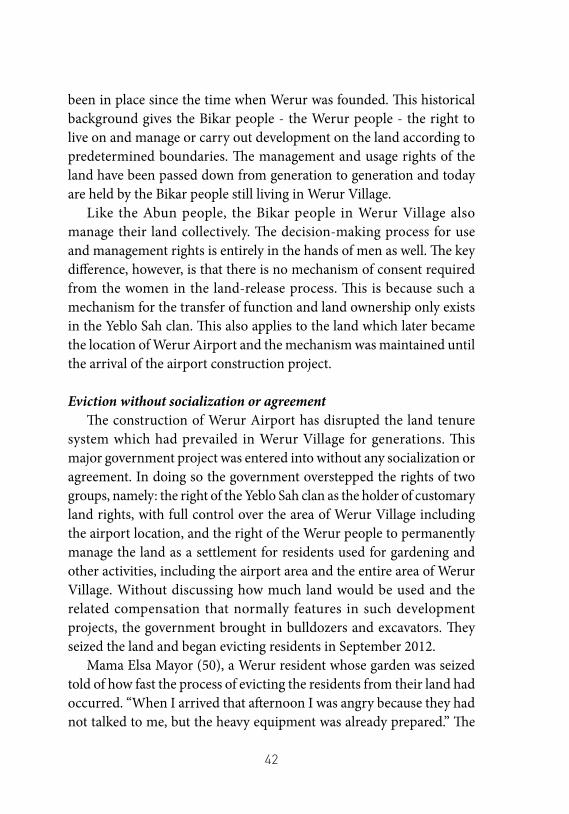
42
been in place since the time when Werur was founded. This historical background gives the Bikar people - the Werur people - the right to live on and manage or carry out development on the land according to predetermined boundaries. The management and usage rights of the land have been passed down from generation to generation and today are held by the Bikar people still living in Werur Village.
Like the Abun people, the Bikar people in Werur Village also manage their land collectively. The decision-making process for use and management rights is entirely in the hands of men as well. The key difference, however, is that there is no mechanism of consent required from the women in the land-release process. This is because such a mechanism for the transfer of function and land ownership only exists in the Yeblo Sah clan. This also applies to the land which later became the location of Werur Airport and the mechanism was maintained until the arrival of the airport construction project.
Eviction without socialization or agreementThe construction of Werur Airport has disrupted the land tenure
system which had prevailed in Werur Village for generations. This major government project was entered into without any socialization or agreement. In doing so the government overstepped the rights of two groups, namely: the right of the Yeblo Sah clan as the holder of customary land rights, with full control over the area of Werur Village including the airport location, and the right of the Werur people to permanently manage the land as a settlement for residents used for gardening and other activities, including the airport area and the entire area of Werur Village. Without discussing how much land would be used and the related compensation that normally features in such development projects, the government brought in bulldozers and excavators. They seized the land and began evicting residents in September 2012.
Mama Elsa Mayor (50), a Werur resident whose garden was seized told of how fast the process of evicting the residents from their land had occurred. “When I arrived that afternoon I was angry because they had not talked to me, but the heavy equipment was already prepared.” The
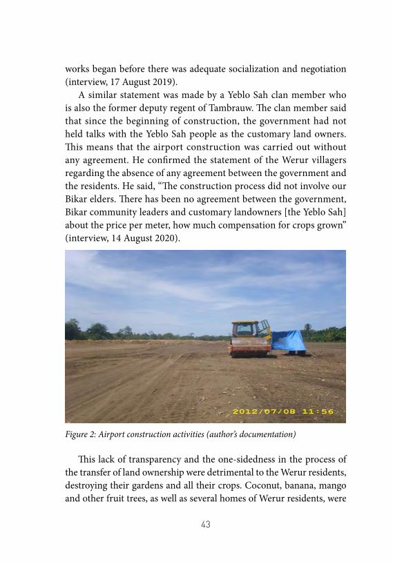
43
works began before there was adequate socialization and negotiation (interview, 17 August 2019).
A similar statement was made by a Yeblo Sah clan member who is also the former deputy regent of Tambrauw. The clan member said that since the beginning of construction, the government had not held talks with the Yeblo Sah people as the customary land owners. This means that the airport construction was carried out without any agreement. He confirmed the statement of the Werur villagers regarding the absence of any agreement between the government and the residents. He said, “The construction process did not involve our Bikar elders. There has been no agreement between the government, Bikar community leaders and customary landowners [the Yeblo Sah] about the price per meter, how much compensation for crops grown” (interview, 14 August 2020).
Figure 2: Airport construction activities (author’s documentation)
This lack of transparency and the one-sidedness in the process of the transfer of land ownership were detrimental to the Werur residents, destroying their gardens and all their crops. Coconut, banana, mango and other fruit trees, as well as several homes of Werur residents, were
44
simply removed for the sake of economic development and growth without adequate socialization and negotiation processes.
This is not to suggest that there has been no initiative from either the Werur or Yeblo Sah peoples. In September 2012, Werur residents, represented by several young leaders, held an audience with the regent of Tambrauw in his office to ask the government for an explanation regarding the presence of a contractor who brought bulldozers onto the lands of the Werur village residents. During the meeting, they asked Regent Gabriel Asem, related officials, and the head of the Tambrauw District House of Representatives (Dewan Perwakilan Rakyat Daerah, or DPRD) to hold a dialogue with the Werur residents and to explain the airport development plan.
This open meeting between Werur residents and the government was held at the end of September 2012 at the Werur Village Hall. Unfortunately, in the meeting, which was attended by the regent and chairman of the DPRD, only a handful of people from the village were present. These were the district head, the head of Werur Village, and some of the people closest to the village head. In this meeting, there was no agreement between the villagers and the government. The residents also did not receive any explanation about the area of the land to be used, the environmental impact assessment (EIA) regarding the impact of the airport on them, nor the mechanism for fulfilling their rights to the land and crops. In the view of the residents, the government made a unilateral decision in the presence of DPRD members, district heads, village heads and their allies.
Furthermore, it appears that no EIA, a prerequisite for obtaining an environmental permit for any development activity (Article 1 paragraph (35) of Law No. 32 of 2009) was ever carried out in Werur. Indeed, no one from Werur claims to have been involved in, met, or even have seen a survey or research team conducting assessments for the airport construction plan.
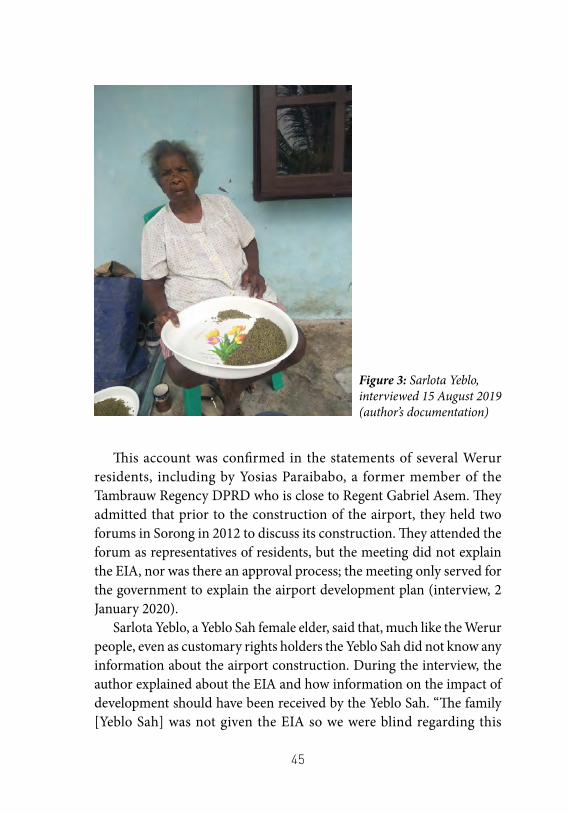
45
This account was confirmed in the statements of several Werur residents, including by Yosias Paraibabo, a former member of the Tambrauw Regency DPRD who is close to Regent Gabriel Asem. They admitted that prior to the construction of the airport, they held two forums in Sorong in 2012 to discuss its construction. They attended the forum as representatives of residents, but the meeting did not explain the EIA, nor was there an approval process; the meeting only served for the government to explain the airport development plan (interview, 2 January 2020).
Sarlota Yeblo, a Yeblo Sah female elder, said that, much like the Werur people, even as customary rights holders the Yeblo Sah did not know any information about the airport construction. During the interview, the author explained about the EIA and how information on the impact of development should have been received by the Yeblo Sah. “The family [Yeblo Sah] was not given the EIA so we were blind regarding this
Figure 3: Sarlota Yeblo, interviewed 15 August 2019 (author’s documentation)
46
airport,” said Sarlota (interview, 15 August 2019).General socialization and efforts to get citizens’ agreement were only
carried out by the Government after the construction began and after residents protested. The government used a variety of approaches to win over citizens to compromise. Several tricks were used by the government to appease the residents, including promising to recruit their children as civil servants, giving them a certain amount of money as compensation because residents’ lands were used without agreement, and even granting the title of Village Head to certain customary landowners. The EIA socialization meeting for residents was only carried out 2 years later, namely in 2014 at Hotel Carstensz Sorong, and even then it only included a few village heads and pro-government community leaders as representatives of the Werur and Abun residents. In the meeting there was no discussion about an agreement between residents and the government on land use, or about the value of compensation.
After the socialization, the Tambrauw Regency Government determined the value of compensation of the lands to the Yeblo Sah people at IDR 10,000 (USD 0.70) per square meter. This price was determined without reference to any regulations because the Government argued that it did not yet have a regional regulation on the value of land prices as a reference point for compensation payments. Apart from land, Tambrauw Regency Government also unilaterally determined the compensation for crops. For each tree, a productive coconut tree was valued at IDR 200,000, while those which had not borne fruit were valued at IDR 100,000. Mango trees and guava trees were valued at IDR 300,000 and IDR 500,000 respectively. These offers were rejected by the Yeblo Sah people because they felt that until the point the airport was inaugurated, they had never given approval for the use of their land (interview with Yance Padwa, 17 August 2019 and with N.Y., 15 August 2019).
The unilateral determination of prices by the government negatively impacted residents. The coconut and mango trees had been planted and cared for by residents for a long time, and these two crops formed the residents’ main saleable commodity in meeting their economic needs.
47
The values determined by the government were also not proportional to the residents income from the crops, with the value of coconut and mango harvests in a single year being higher than the total compensation given by the government after destroying their orchards.
Demands for Compensation and Citizen Protests
Claims for compensationFor example, not one Werur or Abunresident who project information
and details that are commonly made available in government-owned infrastructure development projects have never been provided at the airport construction site. For the duration of the construction, the residents of Werur and Abun only received unwritten information at formal and informal meetings held by the government, or through the very limited information available in the media. Available information on the construction of Werur Airport seems to remain limited. The Werur residents as well as the Yeblo Sah people with whom the author met, unequivocally admitted that they did not know much about the construction, including any related administrative matters.
Until now, for example, not one Werur or Abun resident who has customary land rights has received complete documents for the construction of Werur Airport, either in the form of an Budget Plan (RAB), government decree, EIA, government report or other related document regarding the construction of Werur Airport. The only document that the residents have is a sketch of the planned construction, part of the master plan, which is now held by one of the customary elders.6
6 The author met with all the elders and key figures of the Yeblo who hold customary ownership rights, as well as a number of Werur residents, including the village head, to ask for complete documents for airport construction, but none of them had been given the complete documentation by officials. The author received the same information when verifying the information of the residents by interviewing government officials living in Werur Village, such as the Deputy Regent of Tambrauw and members of the DPRD. They said that they did not have knowledge of the construction documents for Werur Airport. The author also
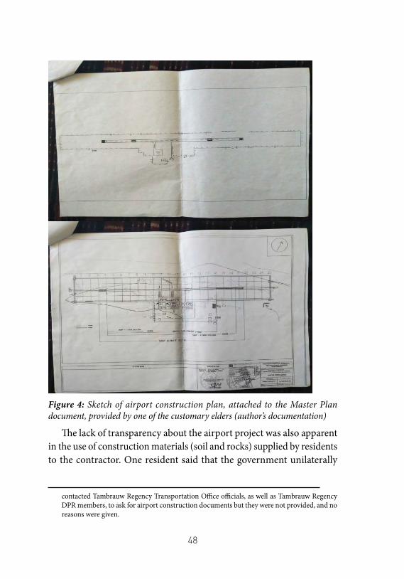
48
Figure 4: Sketch of airport construction plan, attached to the Master Plan document, provided by one of the customary elders (author’s documentation)
The lack of transparency about the airport project was also apparent in the use of construction materials (soil and rocks) supplied by residents to the contractor. One resident said that the government unilaterally
contacted Tambrauw Regency Transportation Office officials, as well as Tambrauw Regency DPR members, to ask for airport construction documents but they were not provided, and no reasons were given.
49
selected four residents to supply materials and determined the value of said materials. Furthermore, the agreements and payments were done without receipts or other written evidence.
Yance Padwa, the former head of Werur Village, stated in an interview on 17 August 2019 that he and the villagers had asked for documents related to the airport construction in order to inform the residents about the details of the project. However, neither the government nor the contractor provided the documentation, nor did they give a reason. “It was not clear,” said Yance, “who the contractor was, how much the project fund was. There was also no project information board”. As a result, the residents were unable to find out how much of their land was being used by the government – making it difficult for them to know how much loss they were going to suffer and to demand the restoration of their rights.
The feelings of the Werur Village residents were clearly contrary to the statement given by the Tambrauw Regent to the media. According to the regent, the first stage of land release and land clearing had been completed. In one statement (Sukmana, 22 September 2014) the regent even explained the value of the project and the details including the payment of compensation for land and crops. “The land area is 200 hectares, there are customary lands and cultivated lands. For the crops, we compensated them IDR 6 billion for the runway and IDR 3 billion for land, a total of IDR 9 billion.”
The Regent’s statement above is a lie. In reality not only were the crops and the materials not paid, but the airport land was also not paid. For the airport land, the government paid only a fine to the customary landowners totalling just IDR 1,150,000,000 (one billion one hundred and fifty million rupiah), rather than any actual compensation. Yeblo residents distributed this money to residents in Sausapor and Werbes, and to Bikar residents in Werur. The fine should not be included in the calculation of compensation money as it was awarded to the customary landowner by way of a penalty. This is in accordance with the customary mechanisms for resolving land disputes for Abun residents, and arose from the fact that the government carried out the airport construction
50
without any agreement.As for the crops and materials belonging to the residents, they were
also not paid in full. The government and the contractor only paid half of what was due, even after the government unilaterally set the price for the compensation of crops such as coconut, mango, and guava (geawas). Not all of these payments were realised; nor were all of the residents’ garden crops paid properly and fairly.
Mama Regina Mambrasar, one of the residents whose land was seized, (interview, 17 August 2019) said that the Government promised to pay off the crops, but at the time of writing this promise had still not been fulfilled. Regina said, “The payment for the crops, only half has been paid, I was told to wait for the other half but it’s not yet paid.” M.W., another resident, (interview, 18 August 2019) talked about their efforts, alongside those of several other residents, to meet with the Regional Secretary of Tambrauw Regency and ask for compensation for their house, the foundations of which measured 8x6 meters. “We’ve met with the Regional Secretary, but he didn’t respond,” said M.W.
Citizen protestsAs explained in the previous section, a lack of information and
unclear land and crop compensation processes are problems that emerged at the outset and have continued during the construction of Werur Airport. Since the beginning, these problems have resulted in many direct protests by local residents. Public protests have generally focused on one of two issues. First, the protests made by Werur residents sought to reject the construction of the airport in Werur Village on the former Allied airstrip site. Second, the protests demanded compensation for the Werur residents who owned the gardens and plants, and the Abun residents who hold the customary ownership rights.
The first protest by Werur residents against the airport construction was held during a meeting with Regent Gabriel Asem and other government officials at Werur Village Hall in 2012. The aim of the meeting between Werur residents and the Tambrauw Regent was to explain the objectives of the airport’s construction. The second protest
51
was carried out by Werur residents a week later. After a face-to-face meeting with the regent, Werur residents stopped the contractor from clearing lands for the airport because there was no agreement. The government immediately responded to this action by deploying troops from the Sausapor military base.
The Yeblo Sah have also periodically held protests to demand compensation by halting bulldozers. They even blocked access to the airport a few hours before it was inaugurated on 13 February 2018. One of the most recent protests was carried out by Soleman Mambrasar who blocked the airport by placing tree branches on the airport runway a few minutes before a plane landed. The aim of his action was to demand compensation for the materials used for the construction of the airport. During the action, which took place not long after the airport was inaugurated, Soleman and two other residents also seized three excavator machines and several other machines belonging to the contractor as collateral (interview with Soleman Mambrasar, 17 August 2019).
The False Promise of Transport AccessThe Tambrauw community has three access routes to travel between
villages and nearby cities such as Sorong and Manokwari. Their two main modes of transport are boats/ships and cars/motorbikes. The travel time and vehicle capacity, which are considered to be sufficient to fulfil the needs of the residents, make these two travel options the most useful and effective choices for Tambrauw residents, and distinguishes them from the third option, the Twin Otter aircraft, which has been operational since the inauguration of the airport.
Figure 5: Twin Otter Aircraft at Werur Airport (Siregar, 15 February 2018)The aircraft tend to be used by Tambrauw residents who live closest
to the airport, as well as residents who need to travel urgently. Air
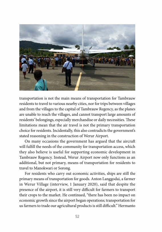
52
transportation is not the main means of transportation for Tambrauw residents to travel to various nearby cities, nor for trips between villages and from the villages to the capital of Tambrauw Regency, as the planes are unable to reach the villages, and cannot transport large amounts of residents’ belongings, especially merchandise or daily necessities. These limitations mean that the air travel is not the primary transportation choice for residents. Incidentally, this also contradicts the government’s stated reasoning in the construction of Werur Airport.
On many occasions the government has argued that the aircraft will fulfill the needs of the community for transportation access, which they also believe is useful for supporting economic development in Tambrauw Regency. Instead, Werur Airport now only functions as an additional, but not primary, means of transportation for residents to travel to Manokwari or Sorong.
For residents who carry out economic activities, ships are still the primary means of transportation for goods. Anton Langgodai, a farmer in Werur Village (interview, 1 January 2020), said that despite the presence of the airport, it is still very difficult for farmers to transport their crops to the market. He continued, “there has been no impact on economic growth since the airport began operations; transportation for us farmers to trade our agricultural products is still difficult.” Hermanto
53
Mambrasar, a civil servant from the Tambrauw regency government who owns a kiosk, agreed with Langgodai. “The price of basic food components from outside the region did not necessarily become cheaper after the airport began operation” (interview, 1 January 2020).
The reason why the aircraft cannot meet the transportation needs of citizens is actually obvious. As many as 90 percent of Tambrauw residents are farmers living in villages in the interior and coastal areas. From this alone, it can be seen that what residents need is improved land transportation and ships or other sea transportation that can carry their goods more effectively than what is available currently. The relatively short distance between Tambrauw Regency and Sorong or Manokwari, or between the villages in Tambrauw, also makes cars and boats the optimal means of transportation for residents.
The argument for the airport development as a source of regional revenue, with Werur airport designed as a commercial airport, which was put forward by Regent Gabriel Asem, is also unfounded and not based on a rigorous study. The regent’s hope that Werur Airport would become a transit airport for tourists to Raja Ampat Regency is unrealistic for several reasons. The first is due to the position and facilities of Werur Airport. Werur Airport is not a transit airport; the Domine Eduard Osok Airport (DEO) in Sorong is more strategic for tourists transiting to Raja Ampat Regency, and also has far more adequate facilities. Better facilities and shorter distances between DEO Airport in Sorong and Raja Ampat, as the center of tourist destinations regionally, and even for several tourist attractions in Tambrauw, make DEO Airport the main transit airport in West Papua. On account of these features, Werur Airport will be unable to replace or compete with DEO Airport as the main transit airport as had been hoped by the Tambrauw government. Instead, Werur Airport will only function as an outpost airport served by Pilatus and Twin Otter aircraft, flying with Susi Air or Trigana Airlines.
Further, the number of potential passengers is low and the lack of customers in Tambrauw Regency will make it difficult for any airline to open new flight routes at Werur Airport. Tambrauw’s population is still
54
relatively small; with the majority of the population of being farmers7 who prefer to use ships and cars there also are very few potential airline customers in Tambrauw. The author heard several stories about the low number of passengers on the Susi Air flights now operating from Werur Airport to serve the Tambrauw-Sorong and Tambrauw-Manokwari routes. However, the author could not confirm this either with the airport management or in official documents issued by the airport.
ConclusionMore than two years since it was inaugurated and began operation,
all the while failing to fulfil the promise of welfare that had been assured by the Regent of Tambrauw, Gabriel Asem, the Tambrauw Regency Government now intends to change the use of Werur Airport. The airport, for which the Werur and Yeblo Sah people lost a lot of land without adequate compensation, is now planned to become a naval air station for Wing III and a forward base for the III Armada of the Indonesian Navy. The Navy has held talks with Regent Gabriel Asem and a number of other regional officials regarding the possibility of using Werur Airport as a military base. It was recorded that as early as 7 August 2018, less than six months after the inauguration, the Indonesian Navy and the Tambrauw Regency Government, represented by Regent Gabriel Asem, held a meeting to discuss the intentions of the Indonesian Navy, with the Navy even conducting a trial landing at the airport (Rahanyamtel, 7 August 2018).
At the time of writing, the planned change of function of the airport, from a civilian airport to a military base, has not resulted in resistance from the residents, at least on the surface. Nevertheless, this step inadvertently strengthens the position of Werur residents and the Abun
7 According to data from the Central Statistics Agency of Sorong Regency (2020: 45) more than half of the total workforce of 6,546 in Tambrauw Regency work in the agricultural sector.
55
people on the futility of the construction of Werur Airport as a means of transportation for people locally. This move also serves to undermine the government’s initial argument to the Tambrauw community, as well as the people of Werur and Abun, about the benefits of the airport for their lives.
References• Badan Pusat Statistik Kabupaten Sorong. 2020. Kabupaten
Tambrauw Dalam Angka 2020. Sorong. Accessed 14 September 2020.
• Fernandez, Mg N. 2014. “Kembangkan Bandara Rp39 M, Kemenhub-Pemkab Tambrauw Teken MoU.” bisnis.com, 22 September. Accessed 14 September 2020. https://ekonomi.bisnis.com/read/20140922/98/259068/kembangkan-bandara-rp39-m-kemenhub-pemkab-tambrauw-teken-mou.
• Hamdani, Trio. 2018. “Jokowi Bangun Bandara Werur, Bekas Peninggalan Perang Dunia II.” detikfinance, 21 October. Accessed 14 September 2020. https://finance.detik.com/infrastruktur/d-4266423/jokowi-bangun-bandara-werur-bekas-peninggalan-perang-dunia-ii.
• Iskana, Febrina R. 2018. “Ke Papua, Menteri Jonan Resmikan Sejumlah Proyek Infrastruktur Energi.” www.kontan.co.id, 15 February. Accessed 14 September 2020. https://industri.kontan.co.id/news/ke-papua-menteri-jonan-resmikan-sejumlah-proyek-infrastruktur-energi.
• Jasa Logistik. 2018. “Bandara Werur – Tambrauw, Bandara Tua Yang Dibangun Kembali.” kargoku.id.
• kumparanBISNIS. 2018. “Jonan Resmikan Bandara Werur Dan PLTMH Warabiai Di Papua Barat.” kumparan, 13 February. Accessed 14 September 2020. https://kumparan.com/kumparanbisnis/jonan-resmikan-bandara-werur-dan-pltmh-warabiai-di-papua-barat/full.
56
• Former Deputy Regent of Tambrauw. 2020. Interview by Y. Mambrasar. 14 August 2020. Sorong.
• Langgodai, Anton. 2020. Interview by Y. Mambrasar. 1 January 2020. Werur Village, Tambrauw Regency.
• Mambrasar, Hermanto. 2020. Interview by Y. Mambrasar. 1 January 2020. Werur Village, Tambrauw Regency.
• Mambrasar, Regina. 2019. Interview by Y. Mambrasar. 17 August 2019. Werur Village, Tambrauw Regency.
• Mambrasar, Soleman. 2019. Interview by Y. Mambrasar. 17 August 2019. Werur Village, Tambrauw Regency.
• Mayor, Elsa. 2019. Interview by Y. Mambrasar. 17 August 2019. Werur Village, Tambrauw Regency.
• M.W. 2019. Interview by Y. Mambrasar. 18 August 2019. Werur Village, Tambrauw Regency.
• N.Y. 2019. Interview by Y. Mambrasar. 15 August 2019. Sausapor Village, Tambrauw Regency.
• Padwa, Yance. 2019. Interview by Y. Mambrasar. August 17, 2019. Werur Village, Tambrauw Regency.
• Paraibabo, Yosias. 2020. Interview by Y. Mambrasar. January 2, 2020. Werur Village, Tambrauw Regency.
• Rahanyamtel, Ahmad. 2018. “TNI-AL Berencana Jadikan Bandara Tambrauw Sebagai LANUDAL Wing Udara 3.” SORONGSAYA.co, 7 August. Accessed 14 September 2020. https://sorongraya.co/metro/tni-al-berencana-jadikan-bandara-tambrauw-sebagai-lanudal-wing-iii/.
• Siregar, Maulina. 2018. “Bandara Werur Papua Barat : Bekas Pangkalan Udara Saat Perang Dunia II: Susi Air Layani Penerbangan Rute Sorong-Werur.” Travia, 15 February. Accessed 14 September 2020.
• Sukmana, Yoga. 2014. “Bandara Di Papua Barat Akan Dibangun Di Lahan Bekas Pangkalan Militer Sekutu.” Kompas.com, 22 September. Accessed 14 September 2020. https://money.kompas.com/read/2014/09/22/121609226/Bandara.di.Papua.Barat.Akan.Dibangun.di.Lahan.Bekas.Pangkalan.Militer.Sekutu.

57
• Widjojo, Muridan S. 2013. Pemberontakan Nuku: Persekutuan lintas budaya di Maluku-Papua sekitar 1780-1810. Depok: Komunitas Bambu.
• Yeblo, Sarlota. 2019. Interview by Y. Mambrasar. 15 August 2019. Sausapor Village, Tambrauw Regency.

59
The Hope for Prosperity, the Demands and the of the Concerns Mbaham-Matta:
A report on the impacts of the Trans-Bomberay Road construction
in Fakfak Regency
by Waldine Praxedes Meak
IN EARLY OCTOBER 2013, in front of 1,200 corporate executives and the heads of various states at the Asia Pacific Economic Cooperation (APEC) High Level Forum in Nusa Dua, Bali, Indonesia’s President Susilo Bambang Yudhoyono (colloquially known as SBY) concluded his opening speech with a straightforward statement about the future of the nation’s development. “Within the next 14 years,” said SBY, “we are targeting to obtain USD 460 billion for investment in 22 major economic activities, which are integrated into eight programs, including mining, energy, industry, maritime, tourism and telecommunications.” What SBY stated had actually already been initiated by his government two years earlier, through a megaproject titled the Master Plan for the Acceleration and Expansion of Indonesian Economic Development 2011-2025 (MP3EI). This flagship development program was publicly launched on 27 May 2011, just seven days after the formal legal foundation for the project was laid in Presidential Regulation No. 32 of 2011.
Almost a year after SBY’s speech in Nusa Dua, and before the inauguration of Joko Widodo as Indonesia’s seventh president in
60
September 2014, news about the unclear future of the MP3EI project appeared in the media. One article mentioned that President Joko Widodo (known as Jokowi) considered not continuing the project, while another stated that the project would be continued with some adjustments (Kuado, 5 September 2014; Rini, 5 September 2014). Officially the MP3EI project was indeed discontinued by President Jokowi. Nevertheless, through the national development schemes and initiatives of the new president, most of the major MP3EI infrastructure projects remained on the agenda (Sari, 18 December 2014).
Among the major infrastructure construction projects that were continued was the Trans-Bomberay Road in Fakfak Regency, West Papua Province. This report will explain how the construction of Trans-Bomberay Road has impacted and affected the lives of the Mbaham-Matta people, an indigenous Papuan tribe living along route of the road in Fakfak Regency, in the period following the announced completion Western Trans-Papua Road in 2018 (Bureau of Public Communication, Ministry of Public Works and Public Housing, 28 February 2018). In researching this report, the author conducted interviews and field observation on three occasions in several villages in Kayauni, Mbahamdandara, Kramongmongga and Kokas Districts, in November 2019, and January and February 2020.
The Trans-Bomberay Road and the Life of the Mbaham-Matta People
Despite the political debacle regarding the abandoning of the MP3EI project, the issue of the Trans-Bomberay Road project has always been clear for the Mbaham-Matta tribe. The construction of the national road, part of the larger Trans-Papua road project, was not affected by the political succession. The road project, cutting across Mbaham-Matta populated regions, went on uninterrupted, while the Mbaham-Matta had no power to determine what was being constructed on ‘their’ lands.
Such a situation was not previously unknown for the Mbaham-Matta
61
people. Paul Haremba, former head of Kramongmongga Village, still remembers well the construction of the road connecting Fakfak and Bomberay, which began at the zenith of former dictator Suharto’s power in 1985. “At that time, citizens were not involved in the road construction process,” said Haremba. According to him, the construction of the road infringed the customary rights of the Mbaham-Matta and destroyed crops and water sources without any compensation. At the time, the Mbaham-Matta community did not demand compensation for damages, reasoning that in the end the road would be beneficial for them, and that through the road’s presence, the government would pay more attention to the livelihoods of the Mbaham-Matta. The road was resurfaced in 1997 (interview with P. Haremba, 31 January 2020).
The Mbaham-Matta people not only made material sacrifices for the construction of the road. The former path, which subsequently became a national road, has a historically important meaning in the minds of Mbaham-Matta people. Soleman Herietrenggi, a resident of Kwamkwamor Village, Kramongmongga district, told of how the path, now subsumed by the Trans Fakfak-Bomberay road, began as a trail pioneered by the ancestors of the Mbaham-Matta who lived in the Mbaham Mountains. The paths which traversed the forest, connected the Mbaham-Matta people to major economic centers on the southern coast, such as Gewerpe (Fakfak District), Air Besar and Danaweria Villages (Central Fakfak District). Due to their significance, the Mbaham-Matta had specific designations for the path according to destination. The Mbaham people around Kayauni and Kokas Districts, for example, called it Wambar Qpara Wri Seng, using the trail to reach the area that today is the centre of Fakfak. The Mbaham people who settled in the village of Nebuktep, Kramongmongga District, use another name, Sikamur, referring to the path to Air Besar Village on the coast, from where they can use a boat to reach the city centre of Fakfak (interview with S. Herietrenggi, 11 November 2019). Beyond this, land has a fundamental function in the lives of the Mbaham-Matta people, as we will explore.
Land, explains Demianus Tuturop, Secretary of Mbaham-Matta
62
Tribal Council of Fakfak, has a meaning comparable to the mother – known in the local language as nou.1 Therefore, the land, including the forests and waters, occupies a position of importance that sustains the structure of traditional Mbaham-Matta society. Land is not only a symbol that determines the position of the clan, it also carries in it the self-identity and pride of each clan. Without rights to the land belonging to the clan, a clan member will be considered as “a person floating on the waves, carried by the currents”. From the communal land belonging to the clan, the Mbaham-Matta have the right to clear land areas and plant crops seasonally for household consumption.2 People who are not members of the clan must plead to the head of the clan to obtain the right to use the communal land, and may never to take ownership of the land. Rivers, trees, meadows, hills and other land features usually mark the boundaries of the land controlled by a clan. When a family that is not related by blood to the clan desires to use land belonging to the clan, they are required to get permission and pay compensation for both the land and crops they may grow on it.
For the Mbaham-Matta people, land also has a spiritual function. Land is like a house that offers protection, as well as providing a place for the spirits of their ancestors to live. It is these ancestors who give the strength for human life. At the same time land is also considered as a place for evil spirits. For example, there are prohibited or taboo places
1 An explanation of the relationship of the Mbaham-Matta to the land is summarized by the author, based on an interview with Demianus Tutorop. (See also: Lefaan and Lelapary, 2015).
2 The Mbaham-Matta people recognise three customary rights in conjunction with the authority, ownership and use of land. These are:
The rights of children to inherit land rights: The right to plant trees such as nutmeg and fruit bearing trees is passed down paternally. However, senior clan members will make the decision on the transfer of the land rights to the son. Daughters in the Mbaham-Matta society are only allowed land usage rights, which are also inherited.
The right to give permission to manage land: This right allows for the granting of permission to manage the land to people outside the clan, to meet the needs of the individual and their family. Granted rights are limited only to the activity of production, and not for the purpose of building a livelihood on the of the land.
The right to consume: This right allows for a man to pass land ownership to his oldest son. In practice, a discussion about the invocation of this right is typically required at the extended family level to avoid conflict.
63
where evil witches scare people and create disaster or mischief (interview with D. Tutorop, 21 February 2020).
Because of these functions, the Mbaham-Matta people are very careful in maintaining and protecting the land. Each process in land management should follow traditional laws of the tribe to keep harmony between the humans and spirits that inhabit the land of the Mbaham-Matta. All acts that destroy or damage the soil, forests or the environment are equated to actions that destroy the Mbaham-Matta.
The Hope for Prosperity, Demands and Concerns
The hope for prosperity The Trans-Bomberay road construction project reached Kriawaswas
Village, Kokas District, in 2009. Amos Wagab (36), a resident of the village, remembers clearly how the project did not run smoothly. “There was a horizontal conflict between the residents and the head of the village, and between the head of the village and the leadership of the company,” he stated, recalling the name of the regionally-owned company that won the tender for the road construction in the village (interview with A. Wagab, 18 August 2020).
Amos Wagab was also able to confirm information the author gathered while conducting desk research. Through his work at the Institute of Human Rights Advocacy (ELSHAM Papua), Fakfak Contact Post, he has had extensive experience working in the villages passed by the Trans-Bomberay Road, especially those located in the Kokas and Bomberay Districts. His recollections regarding the conflict that accompanied the construction of the road, however, were not equally well remembered by the Mbaham-Matta. At least among the residents interviewed, most no longer remembered the problem. The majority of residents only remembered the social and economic changes caused by the construction of Trans-Bomberay Road – changes associated with expectations of prosperity that emerged after the construction of the road began during the New Order era.
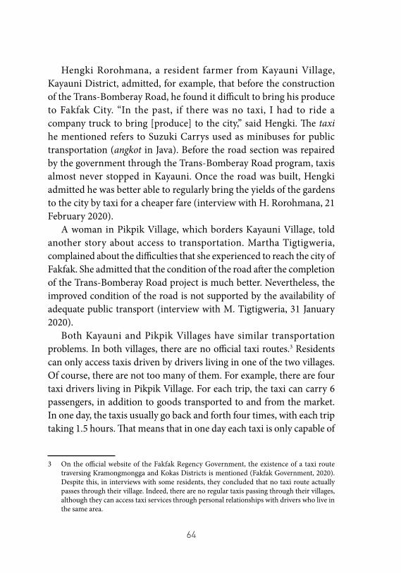
64
Hengki Rorohmana, a resident farmer from Kayauni Village, Kayauni District, admitted, for example, that before the construction of the Trans-Bomberay Road, he found it difficult to bring his produce to Fakfak City. “In the past, if there was no taxi, I had to ride a company truck to bring [produce] to the city,” said Hengki. The taxi he mentioned refers to Suzuki Carrys used as minibuses for public transportation (angkot in Java). Before the road section was repaired by the government through the Trans-Bomberay Road program, taxis almost never stopped in Kayauni. Once the road was built, Hengki admitted he was better able to regularly bring the yields of the gardens to the city by taxi for a cheaper fare (interview with H. Rorohmana, 21 February 2020).
A woman in Pikpik Village, which borders Kayauni Village, told another story about access to transportation. Martha Tigtigweria, complained about the difficulties that she experienced to reach the city of Fakfak. She admitted that the condition of the road after the completion of the Trans-Bomberay Road project is much better. Nevertheless, the improved condition of the road is not supported by the availability of adequate public transport (interview with M. Tigtigweria, 31 January 2020).
Both Kayauni and Pikpik Villages have similar transportation problems. In both villages, there are no official taxi routes.3 Residents can only access taxis driven by drivers living in one of the two villages. Of course, there are not too many of them. For example, there are four taxi drivers living in Pikpik Village. For each trip, the taxi can carry 6 passengers, in addition to goods transported to and from the market. In one day, the taxis usually go back and forth four times, with each trip taking 1.5 hours. That means that in one day each taxi is only capable of
3 On the official website of the Fakfak Regency Government, the existence of a taxi route traversing Kramongmongga and Kokas Districts is mentioned (Fakfak Government, 2020). Despite this, in interviews with some residents, they concluded that no taxi route actually passes through their village. Indeed, there are no regular taxis passing through their villages, although they can access taxi services through personal relationships with drivers who live in the same area.
65
carrying 24 persons. Further, not only the residents of Pikpik, but also those of Kwamkwamor and Bahbadan Villages use their services.4
The lack of available of public transport is in some cases successfully overcome by alternating among the villagers on who makes the trip. This allows more people to get their crops sold at the market, for a reasonable fare of IDR 25,000 (USD 1.80) per person.5 Yet, even this is not sufficient to meet the needs of the entire population of the villages, and some residents have to get around by other methods, for example by getting a ride in the trucks belonging to the palm oil company in Bomberay that regularly pass through the village (interview with K. Hegemur, 31 January 2020). Unfortunately, despite their creative methods, it is often not easy to travel around the times of major religious holidays. At these times, residents need transportation not only for their family members and to transport produce, but also to shop for goods in large amounts. Albertina Herietrenggi, a resident of Kwamkwamor Village, recalled that immediately before Christmas, residents often must hire a taxi at a much higher cost of around IDR 1,000,000 (USD 70) for a round trip from Kwamkwamor to the city. The hugely inflated price must be accepted as there are no alternative transport options available (interview with A. Herietrenggi, 21 February 2020).
The stories above paint a picture of more than just an issue of lack of public transportation in the villages passed by the Trans-Bomberay Road. For comparison, the author tried to count the number of public vehicles operating at the location of the study, in addition to those in the villages already mentioned in the above. Elsewhere in Kokas District, such as in Mambuniibuni, Kriawaswas and Kinam, for example, there is only one taxi that serves the needs of residents. Several villages do not have access to public transport at all. In the villages of Wabung,
4 During the author’s visit to Kayauni Village, the author asked about the number of mothers in the village. The author found an estimated figure of 50 mothers. Assuming the other villages have similar populations, the availability of transport is clearly far from adequate.
5 The fare is not actually fixed, depending on the relationship between the passenger and driver, and according to several mamas, the driver’s mood. On good days, the driver does not ask for a fare, but at other times, the driver may even charge for the transport of the vegetables and tubers being brought to the market. However, the mamas also often tip the drivers.
66
Wos, Mangmangkandak and Mitimber, for example, each village has one pick-up truck belonging to residents, which is operated as if it were public transportation. Similarly, in Waremu and Goras Villages in Mbahamdandara District, there is only one truck and one Ranger pick-up, which are used as a means of emergency public transportation for residents.6
It is important to underline that the availability of public transport is not a trivial issue. The majority of the Mbaham-Matta along the Trans-Bomberay Road live off the yields of their gardens, planted with short term crops (vegetables and tubers), medium term crops (fruits) and long term ones (durian, langsat, rambutan and nutmeg).7 Owing to the diversity of crops grown by the Mbaham-Matta in the villages around the Trans-Bomberay Road, there is an urgent need for cheaply accessible public transport, which is not only limited to transporting people, but also allows the Mbaham-Matta to transport their produce. The need for adequate public transportation of these goods becomes more prominent still when the fruit and nutmeg harvest seasons arrive.
Hery Jose Tigtigweria, a nutmeg farmer in Bahbadan Village, Kramongmongga District, is forced to have traders come to him to buy his crops. This process is done collectively with other farmers in his village, and is considered the most effective option for selling the harvest, as it is not possible to transport nutmeg in large amounts using a taxi or a company truck. However, because the traders travel to them, Hery and the other farmers must accept a lower price, compared to if they transported their crops directly to the city (interview with H. J. Tigtigweria, 31 January 2020).
6 As of 2018, the majority of roads (51.03%) in Fakfak Regency were noted to be in a damaged condition. All these roads are classified as provincial roads (Fakfak Government, 2020). Based on this data, it is highly likely that the villages off the Trans-Bomberay Road have even poorer access to transportation.
7 It was not possible to obtain empirical data regarding the occupations of the Mbaham-Matta people in Fakfak Regency, nor did the author conduct a specific survey for this study. The mention of ‘primary employment’ in this essay is based on observation and interviews with source persons in the field.
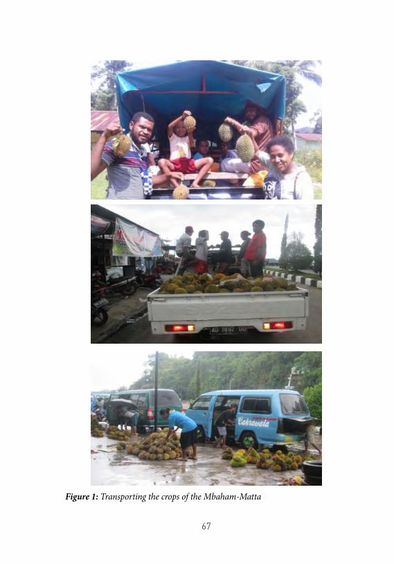
67
Figure 1: Transporting the crops of the Mbaham-Matta
68
In addition to having the buyers come to their village, some other farmers opt for a less economical solution, namely renting a pick-up truck. For this, residents must pay a rental cost of IDR 1,500,000 per trip (interview with A. Hindom, 21 February 2020). If two farmers rent a pick-up truck jointly, an additional fee of IDR 500,000 is charged. The author discovered that the rental price, as with taxi fares, is flexible. In cases where the renter is a relative of the vehicle owner, the rental price decreased to IDR 1,000,000. The cost also fluctuates in relation to the price of commodities in the city. When the commodity price is high, the rental fare also increases.
Demands and concerns8
The absence of adequate public transportation facilities to complement the existence of the Trans-Bomberay Road has not gone unquestioned. In 2018, two years after the road began to be used by the community, ELSHAM’s Fakfak Contact Post tried to convey the difficulties experienced by residents to the Fakfak Regency Regional Representative Council (DPRD) and the Regent. This was attempted for the fourth time in early November 2019. However, each of these efforts failed without ever getting a response.
The requests by the ELSHAM Fakfak Contact Post were not the only times that demands were submitted to the government. The Mbaham-Matta people along Trans-Bomberay Road have also used other means to voice their demands and grievances to the local government. They have repeatedly urged the village heads to submit their demands to the customary institutions. Sporadically, residents have also held meetings with DPRD members who are considered to have kinship ties. Yet, even this approach has thus far resulted in a dead end.
The absence of a government response and action regarding the
8 This section draws heavily from an interview with Amos Wagab (2020) and benefits from Amos’ long experience observing the construction of the Trans-Bomberay Road. Some of the primary data collected by Amos, along with other documentation, was unfortunately unavailable, having been lost in 2018 when Amos was arrested by the police during a demonstration he led.
69
demands and complaints of the citizens is actually nothing new. In the previous section, we noted Amos Wagab’s statement regarding the conflict that accompanied the initial process of building the Trans-Bomberay Road. According to Amos, the conflict that occurred in almost every village passed by the Trans-Bomberay Road lasted for quite a long time, and all came down to the issue of compensation. Even though the Trans-Bomberay road was constructed on top of the old road that had been built during the New Order, the Trans-Bomberay Road project required widening the road, resulting in the clearing of long-term crops belonging to the residents that were planted along the road. This was often carried out unilaterally without confirming who owned the land. In the case of Kriawaswas Village, where Amos Wagab lives, the company that won the tender only coordinated with the village government and village development council (Baperkam), leading to disputes between the crop owners and village officials.
The ensuing tensions, however, never escalated into major protests. For reasons unknown, these sporadic conflicts eventually dissipated without any clarity on the compensation process until now. Residents, according to Amos, “were forced to just give up so that the development could continue.” As a precursor for what was to happen later, the regional government never tried to fulfil the demands of the residents. It is possible that the residents refrained from escalating their protests, at least partly because they viewed the road development as important for them. If the residents had escalated their protests and consolidated them into a bigger wave, they would have had to face the consequences of a halt in the road’s construction. Indeed the road was viewed as vital to improving their economic situation.
The government’s long-held silence has, in the opinion of the author, the potential to cause new and more serious problems in the future by stoking negative sentiment among the indigenous Mbaham-Matta towards migrants. In the last few years, as explained by Amos Wagab, there has been a growing sense in the community of discriminatory treatment by the local government towards the Mbaham-Matta people. They believe that the government has paid more attention to the welfare
70
of migrants, especially those who live in the Settlement Unit areas in Bomberay District. The reason for this stems from a feeling that the lives of migrants are better than those of the Mbaham-Matta people as indigenous Papuans (OAP). Some rumours further question the increase in welfare which was expected to be brought in by the Special Autonomy Fund – whereby instead of bringing prosperity to the OAP, the fund is seen to have benefited migrants more.
Of course, the rumours and allegations that have developed in the community are not supported by evidence. However, this does not mean that these rumours and allegations are meaningless either. Since the completion of the Trans-Bomberay Road, private vehicles, especially vehicles transporting belongings or those driven by migrants concentrated in the Bomberay area are seen more often. These vehicles typically transport agricultural and plantation products cultivated by migrants. Such scenes are inevitably invoked in contrast with the difficulty the Mbaham-Matta people face in transporting their own agricultural produce. It is this disparity, in the opinion of the author, that will trigger the emergence of negative sentiment towards migrants. It is also not impossible that such sentiments will influence how the Mbaham-Matta people see the indirect impact of the Trans-Bomberay Road: traffic accidents.
The operation of Trans-Bomberay Road has made the Mbaham-Matta people witness to a change in the way people drive their cars on the road. The smooth, regularly maintained road, has led to an increase in the speed of passing vehicles. Unfortunately, this has resulted in many accidents where indigenous people’s chickens or dogs have been run over. It is especially indigenous Papuans who are most impacted by the accidents, according to Amos, as most of the harm affects their property.
While spending time in the villages, the author also heard stories of accidents experienced by indigenous Papuans, or their livestock or pets. According to the residents, there have been a number of cases, including one of a person who was hit by a car travelling at high speed. While there is no valid data to confirm the number and proportion of accident cases, Amos’ statement regarding the OAP as the most disadvantaged party in
71
accidents makes sense, considering how the Trans-Bomberay Road cuts through the middle of their settlement, and that most of the drivers of private and public vehicles are migrants.
Irrespective of the statistics, what is more important to note is how these cases are responded to by law enforcement officials. According to Amos, accidents handled by the police often end without clarity. Likewise, the local government does not appear to be making serious efforts to ensure that the Trans-Bomberay Road is used safely and to prevent threats to people living in the vicinity. It is vital that the government achieves these two things, on the one hand in anticipation of and to counter the emergence of tensions between OAP and migrants, and on the other hand to ensure that the OAP, or people living along Trans-Bomberay Road, not live in the shadow of fear. Donatus Tanggahma, a resident of Kramongmongga Village, shared his experience: “My house is facing the road, sometimes I feel scared if my children play next to the main road because they could be hit by a vehicle.”
ConclusionThe Trans-Bomberay Road project, which is a continuation of
the New Order infrastructure development project, came with the expectation of improving the welfare of the Mbaham-Matta people, an indigenous Papuan tribe in Fakfak Regency. This hope was not baseless. It is they, the Mbaham-Matta people, who from the beginning have not only been forced to make material sacrifices in the building of the road, in the form of their land and trees, but also immaterial sacrifices in the form of their collective history and the socio-cultural change that has accompanied the project. Unfortunately, despite their sacrifices, these expectations have not been immediately fulfilled with the completion of the road construction project.
Beyond from the issue of fulfilling the rights and the realising of the hopes of the Mbaham-Matta people, the story of the construction of the Trans-Bomberay Road in the villages of the Mbaham-Matta is also important to observe, because of how it shows that while development
72
projects that may fail to achieve the fulfilment of OAP rights, they can still be realised without encountering significant obstacles due to the pressure of the socio-economic conditions endured by OAPs over the years. Nevertheless, as this research shows, the Trans-Bomberay Road construction project in Fakfak Regency has by no means been problem-free. The construction of the new road without a further program to improve welfare among OAPs, still has the potential to stoke OAP resentment towards migrants. Instead of improving everyone’s welfare, especially OAPs, it remains possible to see how the construction of the road may in fact ignite the fires of conflict in the future.
References• Bureau of Public Communication, Ministry of Public Works
and Public Housing . 2018. “Jalan Trans Papua Barat 1.070 Km Tersambung.” February 28. Accessed August 26, 2020. https://www.pu.go.id/berita/view/15371/jalan-trans-papua-barat-1-070-km-tersambung.
• Hegemur, Katerina. 2020. Interview by W. P. Meak. January 31, 2020. Kampung Mambuniibuni.
• Heremba, Paulus. 2020. Interview by W. P. Meak. January 31, 2020. Kampung Kramongmongga.
• Herietrenggi, Albertina. 2020. Interview by W. P. Meak. February 21, 2020. Kampung Kwamkwamor.
• Herietrenggi, Soleman. 2019. Interview by W. P. Meak. November 11, 2019. Kampung Kwamkwamor.
• Hindom, Alida. 2020. Interview by W. P. Meak. February 21, 2020. Kampung Kriawaswas.
• Kuado, Januarius F. 2014. “Jokowi Isyaratkan Tak Lanjutkan Program MP3EI Dalam Pemerintahannya.” Kompas.com, September 5. Accessed August 04, 2020. https://nasional.kompas.com/read/2014/09/05/17485041/Jokowi.Isyaratkan.Tak.Lanjutkan.Program.MP3EI.dalam.Pemerintahannya.
73
• Lefaan, Ina S., and Heppy L. Lelapary. 2015. Jati Diri Perempuan Asli Fakfak. Yogyakarta: Pustaka Pelajar.
• Fakfak Regency Government. 2020. “Pekerjaan Umum.” Accessed September 23, 2020. https://fakfakkab.go.id/?page_id=357.
• Rini, Annisa S. 2014. “Jokowi Siap Lanjutkan MP3EI Dengan Perubahan.” bisnis.com, September 5. Accessed August 04, 2020. https://ekonomi.bisnis.com/read/20140905/9/255407/jokowi-siap-lanjutkan-mp3ei-dengan-perubahan.
• Rorohmana, Henki. 2020. Interview by W. P. Meak. February 21, 2020. Kampung Kayauni.
• Sari, Elisa V. 2014. “Jokowi Ganti Istilah MP3EI Karena Berbau Politis.” cnnindonesia.com, December 18. Accessed September 15, 2020. https://www.cnnindonesia.com/ekonomi/20141218132635-92-19063/jokowi-ganti-istilah-mp3ei-karena-berbau-politis.
• Tigtigweria, Hery J. 2020. Interview by W. P. Meak. January 31, 2020. Kampung Pikpik.
• Tigtigweria, Martha. 2020. Interview by W. P. Meak. January 31, 2020. Kampung Pikpik.
• Tutorop, Demianus. 2020. Interview by W. P. Meak. February 21, 2020. Kelurahan Fakfak Selatan.
• Wagab, Amos. 2020. Interview by W. P. Meak. August 18, 2020

75
The World Cup in Exchange for Sacred Land: A case study of the East Palapa Ring towers
construction in Kurulu and Itlay Hisage Districts, Jayawijaya Regency
by Benny Mawel
ON 31 JANUARY 2018, the Kurulu District Government facilitated a meeting between residents of Obya and Kimima Villages and a person claiming to be a representative of the company PT Cenderawasih Artha Teknologi (PT CAT)1, together with and Aris Asso, Head of the Jayawijaya Regency Office of Communication and Information (Diskominfo). The meeting, which was held in a courtyard in Kimima Village, Kurulu District, Jayawijaya Regency, sought an agreement on the plan to build one of the East Palapa Ring towers in Kurulu District, but came to a dead end. The two groups of residents from Obya and Kimima Villages clashed throughout the meeting over their conflicting interests, without ever finding an agreement.
1 PT CAT, a company said to be linked to Bahlil Lahadalia, the current the Head of the Investment Coordinating Board (BKPM) under President Joko Widodo’s second term administration, has been named by many in the media as the operator of the East Palapa Ring construction project. Even so, the author was unable to identify an official source confirming the relationship between Bahlil Lahadalia and PT CAT Kendari. Several online media sites mentioned Bahlil’s position as the President Commissioner of PT CAT. PT CAT, as well as PT RIFA Capital, Bahlil’s holding company, do not have official websites at the time of writing. (Haipapua, May 28, 2018; Editorial, May 27, 2018).
76
The first group, the majority of whom consisted of elderly honai2 leaders who did not speak Indonesian, strongly objected to the tower construction plan. They were at odds with the second group, consisting of several youth leaders, church leaders, and officials from the two villages. The strongest reason for the rejection of the plan by the honai leaders was that the area where the tower was to be built was a sacred place for the Dawi-Mawel Alliance - they did not want to repeat the experience of the Amungme Tribe with the Freeport mine in Timika. Decades after the Freeport mine was first established, the Amungme continue to struggle to save their traditional ways of life while facing environmental and human rights abuses committed by the company and security forces.
The opposition between the first and second groups has not changed along the way, even almost two years later on 14 October 2019, when the East Palapa Ring was inaugurated by President Joko Widodo. The dispute rumbles on, as if it had never received serious handling from either the government or the company.
The neglect of social problems arising from the construction of the East Palapa Ring project in Kurulu District, if true, is actually understandable. This project is the final part of an ambitious attempt by the government to build what President Joko Widodo often calls the “sky highway”, to provide internet services across the region through fibre-optic cables, 4G towers and related infrastructure. This is not a new project, and had been under consideration since the 1990s, but was cancelled following the 1998 financial crisis. The project resurfaced in January 2005 at the Infrastructure Summit I in Jakarta, only to be put on ice once again. It was not until the presidency of Joko Widodo in 2015, that the construction project began to be taken seriously in terms of planning, funding and implementation across three phases: West, Central and East. The construction of the West and Central Palapa Rings was completed on 22 December 2018 and was tested in early 2019 in
2 A honai is a traditional round house in the Wamena region, which is symbolic of unity or togetherness. It also refers to a social unit, i.e. an extended family, below the clan level.
77
Tahuna, Sangihe Islands, North Sulawesi.3 Thus, the East Palapa Ring4 became the government’s homework, and the one barrier to being able to declare the entire project complete. As such, the government set a target of July 2019 for the final completion of the East Ring (Syafina, March 20, 2019; Wedhaswary, October 14, 2019).
Furthermore, the Indonesian Government had already publicly announced the primary objectives of the Palapa Ring project in general terms, especially regarding the East Palapa Ring. For a long time, Papua has been seen as one of the regions with the least adequate internet access, and this project is predicted to eliminate the imbalance in internet access across eastern Indonesia, including Papua. In short, through this project the Indonesian government has sought to create internet access in Papua that is equitable and comparable to other regions of Indonesia. In the context of the people of Kurulu District, as is later explained in this paper, these ideals are manifested through the promises of local bureaucrats about improved welfare and equal access, whether for village community members or those living in areas that are more touched by development in Indonesia.
This report examines whether the arguments and promises of equal access and improved welfare presented by the Indonesian government actually hold true in the case of the East Palapa Ring project in Kurulu District, Jayawijaya Regency. In the sections which follow, the author proposes that these arguments and promises have not proven to be completely accurate when it comes to implementation. As the report will go on to explain, Indigenous Papuans (OAP) experience obstacles in utilizing the Palapa Ring in social, economic and educational spheres. Further, the neglect of the rights of indigenous peoples by the government in the process of pursuing the development of East Palapa Ring infrastructure has led to conflicts among indigenous peoples.
3 The Palapa Ring is one of the national strategic projects established under Presidential Regulation No.3 of 2016.
4 Complete details regarding the East Palapa Ring project in Papua can be read in the statement issued by the Directorate General of Management, Financing and Risk of the Ministry of Finance (2018).
78
In compiling this paper, the author defines the research landscape with a primary focus on Kurulu District and some more limited reference to Itlay Hisage District. This is because in the data collection process, the author was only able to access sufficient data and resource persons in Kurulu District, with some additional data gathered in Itlay Hisage District. A limited basis of data was also gathered in Wolo District; the author was not successful in obtaining data from Honelama Village, Wamena City.
Palapa Ring and the Lands of the Dawi-Mawel People
The locations for the construction of the Palapa Ring towers are found in four districts, Wamena, Kurulu, Itlay Hisage and Wolo. It is here that the Yali and Huwula tribes live, two of several indigenous tribes who inhabit the Jayawijaya Regency.
The Huwula tribe lives in the districts of Kurulu and Itlay Hisage. In Kurulu District, the tower construction site is found between Kimima and Obya Villages. These two villages, although administratively separate, actually fall under the same customary area and both are part of the territory of the tribal war alliance of two clans, namely Dawi and Mawel.
The customary land ownership model in Kimima and Obya villages, and generally among the Yali and Hubula tribes, was founded on clan or war alliances. The land ownership in the two villages is collectively held by the two clans, Dawi and Mawel, in a customary structure known as an alliance,5 in this case the Dawi-Mawel Alliance. These communal property rights are then divided into plots of utilization rights or
5 An alliance is a customary structure commonly found among the tribes in Jayawijaya Regency. According to the Dawi-Mawel elders, alliances have been formed since their ancestors first entered the Baliem Valley. Initially, this alliance was a war alliance formed by local tribes engaged in wars to maintain or seize control of customary lands or territories. The story of the formation of the alliance lives on in the memories of the village elders and is retold during traditional ceremonies.
79
inheritance rights whose control falls under a honai - the social structure beneath that of the clan - with regard to the right to cultivate. The tenure of this right to cultivate is determined based on stories of ancestors, war victories, or objects of ancestral heritage in the form of place names, such as former gardens and villages.
The entire land belonging to the Alliance is divided into two areas, namely sacred areas and cultivated areas. The owners of the sacred areas are tasked with performing traditional rituals to maintain soil fertility. Holders of the right to cultivate, on the other hand, maintain the tenure of the right to cultivate the communal land, and are obliged to follow customary rituals by giving compensation to the owners of the sacred areas. Neither the holders of cultivation rights nor the keepers of the sacred areas have the right to unilaterally relinquish land ownership. The submission of any assets to another party is illegal without consultation or permission from the power-holder, namely the Dawi-Mawel Alliance, which is represented by elders from both clans who are endowed with a mandate.
The complicated mechanism for releasing land ownership in Kimima and Obya is understandable. As is common among many other indigenous peoples, land holds an important place of the lives of the Dawi-Mawel Alliance. It is on the lands that the majority of the population depend for their livelihoods as farmers and pig breeders.
Agriculture in Obya and Kimima still follows traditional methods, using hand tools such as hoes, shovels and machetes. Typically they grow tubers and vegetables. The most commonly grown tubers are sweet potatoes or patatas, while the vegetables they grow include cabbage, mustard greens, carrots and spinach, as well as patatas leaves. The most popular livestock is pigs, but some families also farm cattle or fish.
Agricultural activities are not fully market oriented. Most of the produce is used for everyday family consumption. Livestock and fish are usually only killed to fulfil communal functions such as traditional ceremonies, religious ceremonies and community meals to celebrate the achievements of family members or clans. Occasionally, livestock and fish will be sold if families need money to pay for children’s schooling
80
or to buy additional necessities: soap for bathing and washing, cooking oil, salt, herbs and spices, and rice, which is not grown locally or part of a traditional diet in the region, but which has become more popular since since Papua became part of Indonesia.
Education in Obya and Kimima is very limited. Due to a lack of educational infrastructure, the only schools available are primary schools. School facilities are limited and very few teachers are available. The schools are generally made up of classrooms without a library, and are not equipped with teaching aids or textbooks. The only primary school in Obya, the SD Inpres, was founded in the early 1980s and has never been renovated since. The school still does not have a latrine, and the school building and teachers’ houses are becoming decrepit with age.
Money, Land Rights Claims and Unilateral PermitsEven since the inauguration on 14 October 2019, the process of land
transfer for the construction of the Palapa Ring tower between Kimima and Obya Villages has remained a mystery. Of those who took part in interviews, the majority of people in the two villages admitted that their knowledge about the tower construction process was limited to having helicopters flying over them, and occasionally seeing workers and project officers transporting building materials to locations far from their settlements.
The site of the tower construction is located far atop a mountain that residents call Mount Wun Fakfak, around 10 km from Kimima and Obya, which are situated in the valley. This made it almost impossible for residents to follow the construction process, let alone to scrutinize the tower development in detail. Apart from the construction of the tower itself, residents’ primary recollections are of promises of free internet and ease in conducting online business that were presented by Diskominfo officials in early 2018.
The Head of Kurulu District admitted that he had only been invited to participate in a meeting about the development once, on 8 March 2018. During the meeting, he listened to the description of the
81
development plan and filled out the attendance list. A detailed exchange was not on the agenda. “I received a million (USD 70) [for coming to the meeting], because it was my share.”6 He seemed to feel that the payment was compensation for his time, an administrative fee he was entitled to as a local official. The district head’s statement was corroborated by Pilatur Logo, another resident who took part in the meeting. Pilatur received IDR 300,000 to come to the meeting. “I don’t know how much the others received.”
The elders of the Dawi-Mawel Alliance were no more knowledgeable about the process. The five mandate holders of the Alliance’s land ownership committee admitted that they never carried out a process to hand their land over to either a private company or to the government. Four elders from the Mawel clan, referred to here by the initials H, N, Y, and W confirmed the same.
Y and W’s accounts may help to understand the land issue in the construction of the Palapa Ring tower. In interviews, alliance and clan elders mentioned that the Palapa Ring tower stood on their customary honai. Thus, as a result, rumours flew regarding the possible involvement of the two honai elders in the construction process of the Palapa Ring.
Y and W themselves, did not deny the position of their honai as the entry point to the tower’s construction. As the people of Dawi-Mawel later discovered, the Mawel honai led by Y and W suffered from internal conflicts between its younger and older members. Of the Mawel clan, T, B and 8 other younger members, were identified by the residents as the ‘culprits’ who had allowed the tower construction to proceed. They were considered to have unilaterally, and without the knowledge of elders, granted permits to the company and the government.
This conclusion is not without evidence. Since the tower construction plan first became apparent in a socialization meeting in Kimima and Obya, held in early 2018, T and his friends led a group of younger clan members in supporting the construction of the tower. During the
6 Head of Kurulu District, in dialogue with the customary rights owners, the Ministry of Communication and Information and the company, 8 March 2019.
82
meeting, W recalled feeling that T and his group insisted to have their way, against the position of the elders who refused the construction on the grounds that they did not want to repeat the bad experiences of the Amungme Tribe in Timika (interview with W, 10 March 2019).
Later, the residents became more and more convinced that T and his friends had pushed for an agreement among the Dawi-Mawel Alliance against others’ wishes. This became especially prominent after word got out that T had proposed a compensation amount to the company. A resident interviewed in Obya Village said that initially, the company offered compensation of IDR 200 million. This offer, according to the residents, had never received any approval, “but [T and his friends] asked for an additional IDR 50 million” (interview with PL, December 2019).
Some residents believed that the company complied with T’s proposal. According to one resident, this was evident in how T became more confident in influencing the residents who rejected the tower. Residents also told of how T and his supporters distributed between IDR 2-5 million for each honai. Imitating T, one resident quoted, “Bapa, Mama, this tower is for development. We have to smoke cigarettes for development. We have smoked cigarettes for development, no?” (interview with NM, 31 January 2018).
Not everyone who received money agreed to the project. Some people interviewed stated that they wanted to rejected the plan but were forced to accept, even though they continued to refuse the money. W, for example, told the author that he refused IDR 5 million that B had been about to give him. “You can have it. Take it. I’m not a beggar,” he had said. Another Dawi elder had a similar attitude and refused the money, reasoning that he was afraid of selling sacred land (interview with NM, 31 January 2018).
Considering the process of land release and the resulting internal conflict in the Dawi-Mawel Alliance from a broader perspective, there remain certain unanswered questions. Diskominfo, the office which handled the acquisition, ought to have known exactly how a process of releasing land in customary areas should be carried out: that the local community who are the rights holders must issue a release with the approval or knowledge of the local customary council. Yet, they
83
admit that in fact they had no idea about the process. In a report on the results of a discussion at the Kurulu District office in 2019, the Head of Diskominfo implied the agency’s ignorance of the process for the East Palapa Ring tower construction, stating “I don’t know about the release process yet,”7 as if the release process had never been known by the office.
Likewise, the Kurulu District Government claimed that it has never processed a release letter from the customary council as legal evidence of the release by the indigenous community. “I do not have such a letter to this day,” said the Kurulu District Head (interview, 1 December 2019). Indeed, T himself said the same thing in an interview with the author. “I don’t have any letter. If I had it, I would definitely show it. Honestly, I don’t have it because [the company and the government] didn’t give it” (interview with T, 31 December 2019).
It is important to note that irregularities such as these which are apparent in the process of building the East Palapa Ring tower between Kimima and Obya Villages, also occurred at the Palapa Ring construction site in Jayawijaya. In Miami Village, Itlay Hisage District, about 15 km from Kimima and Obya, the land acquisition process for the East Palapa Ring tower also caused an altercation. Like in Kimima and Obya, all the land in Miami Village is part of the customary territory of a local clan alliance, in this case the Molama-Lokobal Alliance. The indigenous alliance consists of two clans, namely the Asso and Molama-Lokobal clans. The location for the construction of the tower, is in an area known by residents as My Mountain, which belongs to the two clans, wherein the Asso clan hold a cultivating right, while for the Molama-Lokobal, it is deemed a sacred place (wakunmo).
Wakunmo is a symbol of customary rights ownership. For this reason, the Molama-Lokobal clan strongly rejected the construction of the tower. This rejection was initially supported unanimously by the Asso clan. However, in the course of the process, P, the leader of the Asso clan,
7 Words of Isak Sawaki, Head of the Jayawijaya Office of Communication and Information, in a chronological report compiled by the people of Obya and Kimima villages (Residents Owning the Authority of Wun Fakfak Forest, 2019).
84
was successfully influenced by Z, the head of Miami Village, to accept the tower construction plan. Without agreement at the customary alliance level, the construction project then went on to completion. YM, one of the mandate holders of the customary alliance for Molama clan, as well as the central figure leading the opposition against the construction of the tower, expressed his astonishment regarding how the tower construction could be carried out without agreement from each of the clans. He stated that he had never once held a customary land release process (interview, 17 April 2019).8
The tower construction in Miami Village has resulted in a swathe of problems. As in Kimima and Obya, compensation money has presented an equally complex issue. Early in the tower construction process in Miami Village it was rumoured that through the Miami Village Head, the company approached P with an offer equal to that reported in Obya and Kimima, namely IDR 200 million. The money was promised to be sent in instalments via bank transfer. According to a resident, P accepted this offer on the condition of receiving additional administration fees and two wam (pigs) worth 100 million.9As in Kimima and Obya, the compensation money did not only serve to line clan leaders’ own pockets. Interviewees met by the author testified that the money was divided between each honai according to size. The large honais received IDR 5 million, while small ones received between IDR 2 - 3 million.
However, in Obya, Kimima and Miami, rumours circulated suggesting that clan leaders were getting the lion’s share. In Miami, P and Z were suspected by residents of using the money to buy a property
8 When discussing the process of building the Palapa Ring towers in Kimima, Obya and Miami Villages, the Papuan Customary Council of the La Pago region gave more or less the same account as the elders of the Dawi-Mawel and Molama-Lokobal Alliances. Acknowledging that they should have been responsible for any release process, they said that they never heard of a customary relinquishment process in this case, nor had they issued a release letter on behalf of the institution to allow for the construction of the towers.
9 The same information is also found in two documents written by residents. The first is a report dated 6 February 2018, entitled Community of Citizens Caring for the Sacred Area of Jayawijaya. The second is a protest letter addressed to the Jayawijaya Regency Government dated 23 February, sent on behalf of the “Wun Fakfak - Timpuapma Forest Area Authority Owner.”
85
in the city of Wamena and to finance their son’s campaign to become a legislative candidate for one of the political parties in Jayawijaya Regency in the 2019 elections.
Issues Surrounding the Tower ConstructionSince the disagreements between factions in the Obya and Kimima
communities first occurred during the meeting held on 31 January 2018 at T’s house in Kimima Village, and again at the second meeting on 8 March 2019, held at the Kurulu District Office, a number of fatal incidents have occurred. These have either taken place in Obya and Kimima Villages, or have involved people from the two villages. Some residents have linked these cases to the East Palapa Ring tower construction project, because they happened to members of the clans who owned the customary rights.
The first incident occurred on 31 March 2018. At around 9 pm, a woman suspected of having a mental disorder stabbed six women to death in Umpagalo Village and injured two others who died later while receiving medical treatment. There was no further investigation into this case, as the perpetrator was herself killed by the enraged villagers, who took justice into their own hands.
However, some residents believe that the stabbing was not carried out solely by the woman. According to a source whom the author met, it was the Yalige,10 “the owner of the mountain’s shoulder”, who committed the stabbing through the poor woman, explaining a relationship between the stabbing incident and the construction of the tower. The mountain here refers to where the tower was built (interview with LL, December 2019). The connection between the murder case and the construction of the tower was believed to be stronger because before the woman killed, she stated “An wene nokodek. Wene hir hinilu ooo”. [“I don’t know this. You know better why.”]
10 According to the Huwula people’s beliefs, the Yalige is a supernatural being and a guardian of nature, especially of sacred places.
86
Another incident occurred in November 2018, this time in the form of a traffic accident. Two people from the Logo clan, a father and his son, died instantly in an accident on Trans Wamena-Jayapura road. Finally, in 2019, a young man from the Mawel clan also died in an accident.
Of course it is not possible to prove the link between these deaths and the construction of the tower. Nevertheless, the narrative developing among the residents can be considered as a model of social punishment by the Dawi-Mawel who rejected the tower’s construction, of those considered to be associated with the project or who chose not to voice their opposition openly.
Indeed, since the construction of the tower began, residents have also realised that the Dawi-Mawel Alliance itself has split, with each party blaming the other. Tensions have sometimes manifested in arguments. In relation to the deaths thought have arisen from the project, for example, the Dawi-Mawel have started arguing about who is responsible for the bad karma that has caused the death of their brethren. Sometimes there are no outright arguments, but cynical insults are exchanged. Even so, these sparks have never yet flared up into a serious conflict or resulted in fighting between residents.
Aside from the internal conflicts that have arisen among the Dawi-Mawel Alliance, one thing to explain here is the question of how the promises made by the Indonesian government and communicated through the Jayawijaya Diskominfo Office have impacted people’s lives. Since the beginning, the Jayawijaya Regency Government, through Diskominfo have said that the community would receive many benefits resulting from the construction of the East Palapa Ring tower. It was also said that people would have access to better telecommunication networks than before. In fact, residents still remember very well the promise of the Head of the Jayawijaya Diskominfo Office, Isak Sawaki, on free internet access. People would be able to access information from around the world: “Watch the World Cup!”, residents reported Sawaki as saying. Not only that; according to Sawaki, the East Palapa Ring could make it easier for residents to obtain information, education, economic improvement and jobs. “Children can open businesses. [There will be]
87
online examinations and online civil servant tests. You want to eat, simply make an order, you don’t need to go to a shop.”11
Similar promises were made to residents of Itlay Hisage District. In a socialization process involving the communities of four villages, Miami, Wuroba, Siliwak and Helepalegem, the government explained that the tower construction project was aimed at making the community prosperous. They heard that the community would be able to stay in their gardens and not have to bring their produce to the market because the buying and selling process would be carried out online. “Every vegetable crop will not need to be brought to the market and sold, but they [buyers] will see them through a camera - they will come by helicopter and buy them directly in the garden” (interview with the Secretary of the Huwula Customary Council, December 2019).
The Jayawijaya Regency Government said that the promise of free internet would be realised in 2020 by installing as many as 138 Wi-Fi points through the Nusantara Wi-Fi Program (JPNN.com, 2020). How many gigabytes will the government provide the community? For how long will people receive the free internet service? Which community groups will receive it? These are questions which the government has not yet answered in any detail. However, in some cases there are parameters available to measure the extent to which the internet has benefited indigenous Papuans in the two districts. One of them is through the experience of the District Internet Program, which has existed long before the Palapa Ring.
In Oboya Village, the access point for the District Internet Programme was located at the Yiwika elementary school. Paulus Himan, one of the elementary school teachers, said that the internet had caused problems. Instead of learning by using the internet, children went to school not to study but to seek entertainment via the internet. As an educator, Paul tried a tactic to deal with this and to ensure that the internet at his school was used to aid the learning process. He turned off the internet during
11 This statement was obtained by the author when attending a dialogue with the community during a visit to Kurulu District on 1 February and 8 March 2019.
88
school hours, except for the purpose of studying in class. However, this tactic apparently failed because when classes were over the pupils did not return home. Instead, they played on the internet until late afternoon when he would have to order the children to go home. Often after being sent home, the children would return again late in the afternoon or evening. Indeed at night the adults would also come to use the internet. “They (the adults),” said Paulus, “could play until the next morning. [They would] urinate anywhere around the school, not in the proper location.” Internet access, according to Paulus, makes it easier for both children and adults in the village to have online dates. “Do you think the kids are only sitting there? They are watching porn, and making out on the internet. It is difficult for us to limit it,” (interview with P. Himan, 5 February 2019)
Another source told an even more depressing tale of how the internet in the village is used by young people as a vehicle for purchasing marijuana. “They can order the drugs via Facebook, bring them to the school. They enter the classrooms and smoke for hours.” They said that it is through the internet that local young people find out about marijuana and where it can be bought. The problem is complicated by several cases of parents being billed for marijuana purchases made by their children.12
ConclusionIn understanding the narrative about the land transfer in the
construction of the East Palapa Ring towers, one piece of the puzzle has remained elusive: how is it that the process could run relatively smoothly, without encountering significant obstacles? Unexpectedly, the internal conflicts in Obya, Kimima and Miami never escalated into open conflict. In observing and interacting with the residents for more than two weeks in Kurulu, the author hardly found any narratives
12 This resource person gave these comments during a discussion about the chronology of the arrest and detention of AM, a Kurulu youth, in relation to narcotics cases at the Papua Provincial Narcotics Agency on 11 March 2020.
89
about violent horizontal clashes between the residents during the tower construction process.
One possible clue that still needs to be investigated further is the involvement of the military. This clue emerged through the accounts of several residents in Kimima and Obya, who told the author that they had been paid to carry loads up the mountain where the tower project was located. “I thought it was construction equipment,” said the resident, “but it (turned out) to be bullets.” Another story mentioned the existence of a military post about one kilometre up the hill, which secured the tower construction process. The author attempted to verify the existence of this military post, but was hindered due to physical limitations and challenging terrain.
Proving the veracity of these stories requires an in-depth investigation, which was unfortunately outside of the scope of this research. Nevertheless, the author is of the opinion that the tale about military support and protection in the process of building the tower may have helped accelerate the tower construction process, which was carried out without the customary approval of the Dawi-Mawel Alliance. At the very least, the story may have effectively suppressed the citizens’ courage to protest any louder.
Aside from the possible role of the military in the process of building the East Palapa Ring towers in Jayawijaya Regency, especially in Kurulu, the promises made by the Indonesian government, transmitted through local officials to the residents of Kimima, Obya and Miami, are important to underline. The failure to make good on these promises not only indicates systematic deception in the Palapa Ring construction process, but possibly also in other infrastructure development projects in Papua, and must be taken seriously. More than that, the failure to uphold their promises can be seen as a manifestation of a self-serving attitude, indifference and ignorance on the part of the Indonesian government in infrastructure development in Papua.
It makes little sense for the government to be unaware of the failure of the existing internet program in Kimima, Obya and Miami. It is also difficult to believe that the government did not implement an evaluation
90
process for this program. Despite all the positive thinking that the author has put forward, the only way to understand the development of the East Palapa Ring in Jayawijaya, the heralded goal of which was named as improving internet access for local residents, is that actually the construction of internet towers from the beginning was not intended for the Kimima, Obya and Miami residents. More precisely, perhaps, the construction of the towers were never intended for the majority of indigenous Papuans in the Jayawijaya region; those who do not have access to education and adequate educational infrastructure and knowledge. Indeed if this is so, it would mean that all the sacrifices of the people of Obya, Kimima, and Miami, including their sacred lands, were in vain.
References • Direktorat Jenderal Pengelolaan, Pembiayaan, dan Resiko
Kementerian Keuangan. 2018. “Palapa Ring Paket Timur.” Accessed August 19, 2020. http://kpbu.djppr.kemenkeu.go.id/proyek/palapa-ring-paket-timur/.
• Haipapua. 2018. “Kerjakan Proyek Palapa Ring Timur, PT Cenderawasih Arta Teknologi Datangkan Heli MI-26.” May 28. Accessed September 24, 2020. https://haipapua.com/kerjakan-proyek-palapa-ring-timur-pt-cenderawasih-arta-teknologi-datangkan-heli-mi-26/.
• JPNN.com. 2020. “Tahun Ini, Warga Jayawijaya Papua Dapat Internet Gratis.” JPNN.com, January 20. Accessed November 09, 2020. https://www.jpnn.com/news/tahun-ini-warga-jayawijaya-papua-dapat-internet-gratis.
• Presidential Regulation No. 3 of 2016• Redaksi. 2018. “Angkut Material Palapa Ring Timur, Helikopter
Didatangkan Dari Moskow.” KabarPapua.co, May 27. Accessed September 24, 2020. https://kabarpapua.co/angkut-material-palapa-ring-timur-helikopter-didatangkan-dari-moskow/.
• Syafina, Dea C. 3/20/2019. “Perjalanan “Infrastruktur Langit”: Mega Proyek Sejak Orde Baru.” Tirto.id, 3/20/2019. Accessed
91
September 24, 2020. https://tirto.id/perjalanan-infrastruktur-langit-mega-proyek-sejak-orde-baru-djUd.
• Warga Pemilik Kuasa Hutan Wun Fakfak. 2019. Laporan Nomor 01/WPK/2019 Tetang Desakan Peninjauan Kembali Pembangunan Tower Satelit Palapa Ring C5 Di Hutan Wun Fakfak.
• Wedhaswary, Inggried D. 10/14/2019. “Perjalanan Palapa Ring, Dicetuskan Sejak 2005 Hingga Diresmikan Jokowi Halaman All - Kompas.Com.” Kompas.com, 10/14/2019. Accessed August 19, 2020. https://www.kompas.com/tren/read/2019/10/14/191700465/perjalanan-palapa-ring-dicetuskan-sejak-2005-hingga-diresmikan-jokowi?page=all.
Interviews:• Himan, Paulus. 2019. Interview by B. Mawel. February 5, 2019.• Kepala Distrik Kurulu. 2019. Interview by B. Mawel. December
1, 2019. Wamena.• LL. Interview by B. Mawel. December, 2019. Kurulu.• NM. 2018. Interview by B. Mawel. January 31, 2018. Kurulu.• PL. Interview by B. Mawel. December, 2019. Kurulu.• Sekretaris Dewan Adat Huwula. Interview by B. Mawel.
December, 2019. Kurulu.• Y T. 2019. Interview by B. Mawel. December 31, 2019. Kurulu.• W. 2019. Interview by B. Mawel. March 10, 2019. Kurulu.• YM. 2019. Interview by B. Mawel. April 17, 2019. Kurulu.

93
About the Authors
BENNY MAWEL is a Papuan journalist. He works as a journalist at jubi.co.id (2011-present) and is a contributor to www.ucanews.com and the Jakarta Post on human rights issues. He was involved in research with ELSAM Jakarta in collaboration with Peace Brigades International (PBI) in 2015 and 2019. In 2018, he received an investigative scholarship from Tempo to research health issues in Papua.
Outside of his journalistic activities, Benny is an opinion writer. His writings on Papuan development issues can be found in the tabloid Suara Perempuan Papua, suarapapua.com, and jubi.co.id.
PILIPUS ROBAHA is active in the organizing and political education of the people, especially among the younger generation of Papuans. In this capacity he has worked in several Papuan youth movement organizations, advocating on the right to freedom of expression and for the self-determination of the Papuan people. In carrying out humanitarian and organizational work, he often partners with GKI Synod, GKI Papua and SKPKC Franciscans Papua. Pilipus studied at Yapis University Papua is now the deputy chairman of the Papua Youth and Student National Solidarity Organization (SONAMAPPA).
WALDINE PRAXEDES MEAK is a Papuan activist working on issues of human and women’s rights. Waldine was born and lives in Fakfak. Since 2009, she has represented the KELOMANG community which promotes organic farming and women’s economic empowerment.
94
YASON NGELIA was born on 6 October 1990 in Getentiri, Boven Digoel, Papua. Yason completed his basic education at Boven Digoel junior high and high school in Merauke. In 2008, Yason moved to Jayapura City to continue his undergraduate education in Government Science at FISIP Cenderawasih University, Jayapura. Since he was a student, Yason has been active in various movements and organizations working on issues related to democracy and human rights.
Outside of his activities as a movement activist, Yason is a writer. In 2018, he published a book entitled Papuan Student Movement. An earlier essay of his was featured in the anthology on human rights defenders, Writing for Rights, published by ELSAM in 2016.
YULIANA LANTIPO is a Papuan journalist working on issues of human rights and politics in Papua. Yuliana lives in Jayapura and works as an editor at jubi.co.id. Yuliana was the first alumna to complete the Basic Course for Human Rights Defenders, jointly organised by ELSAM and PBI in 2015.
YOHANIS MAMBRASAR, S.H. completed his law studies at the Faculty of Law, Cenderawasih University in 2012. Until 2016, Yohanis was active in advocating for indigenous Papuan traders in the Solidarity Forum for Indigenous Papuan Traders (SOLPAP) with the late Robert Jitmau. In 2014-2015 Yohanis joined the Yayasan Anak Dusun Papua (Yadupa). Now, Yohanis is a public lawyer at the Papuan Human Rights Lawyers Association (PAHAM). In 2016-2017, he was an Assistant Public Lawyer with LBH Jakarta. As a lawyer, Yohanis is active in providing legal assistance for Papuan treason suspects and other victims of violence. In September 2019 Yohanis was awarded the 2019 Hukumonline Award in the category of ‘Most Inspiring Lawyer in the Non-Litigation Pro Bono Field’. Since the beginning of 2020, Yohanis has organized the formation of the Babeoser Bikar Community in Tambrauw, West Papua.