Embed Size (px)
Citation preview
,
(CTP~ 3
I ~b ~ )Lttt
COMMONWEALTH OF AUSTRALIA
DEPARTMENT OF NATIONAL DEVELOPMENT
BUREAU OF MINERAL RESOURCES GEOLOGY AND GEOPHYSICS
RECORDS:
1968/44
B.M.R. MARmE GEOLOGY CRUISE IN THE SOLOMON SEA 10/1/68 to 24/2/68
by
C.C. von der Borch
The infonnation contained in this report has been obtained by the Department of National Development, as part of the poli~y of the Commonwealth Government, to assist in the exploration and development of mineral resources. It may not be published in any fonn or used in a company prospe¢tus without the permission in writing of the Director, Bureau of Mineral Resources, Geology and Geophysics. ,
IS928/6S
'v
B.M.R. MARINE GEOLOGY CRUISE IN THE SOLOMON SEA 10:1:68 to 24:2:68
by
C.C. von der Borch
Records 1968/44
INTRODUCTION
Personnel Vessel Recommendations
EQUIPMENT
Echo-sounders Seismic profiler Winches Sampling equipment Additional recommendations
CRUISE NARRATIVE
PRELIMINARY RESULTS
Milne Bay Gomwa Bay Lae-Morobe shelf and canyons Rabaul Harbour Rock dredge samples
CONTENTS
FUTURE WORK IN THE NEW GUINEA - SOLOMON SEA AREA
Vitiaz Strait Trobriand Islands - Woodlark Island area Banks east of Rossel Island Solomon Island region Timing of surveys .
Page
1
1 2 2
3
3 3 4 4 5 6
7 7 8 8 9 9
9 10 10 10 10 10
The information contained in xhis report has been obtained by the Department of National Development, as part of the policy of the Commonwealth Government, to assist in the exploration and development of mineral resources. It may not be published in any form or used in a company prospectus without the permission in writing of the Director, Bureau of Mineral Resources, Geology and Geophysics.
B.M.R. MARINE GEOLOGICAL CRUISE nITRE SOLOMON SEA 10/1/68 to 24/2/68
by
C.C. von der Borch.
INTRODUCTION
This report covers the six week period from 10th January 1968 when the writer was Cruise Leader of the B.M.R. marine geological party in the charter vessel S.S. Kos II. In addition to a cruise narrative and a brief discussion of the results, some comments are made on the ship and on the equipment carried and recommendations are put forward regarding future surveys.
The writer left the vessel in Rabaul on 24th February when he was replaced by Dr van Andel of Scripps Institute of Oceanography. Further sparker traverses were carried out with van Andel on board before the Kos II returned to Australia on the 11th March.
Personnel
Scientific personnel on this section of the 1967-68 B.M.R. Marine geological cruise were as follows:
Dr C.C. von der Borch -!vIr R. Thieme !vIr F. Walraven Mr D. Jongsma Mr R. Dulsky !vIr M. Tratt !vIr R. Williams
Cruise leader Geologist Geologist Geologist Technical Technical Technical
Officer (electronics) Officer (mechanical) Assistant
-2-
Vessel
The vessel used during the survey was the ex whale-chaser "Kos II", a steel ship of 125 feet overall built in 1929 and powered by a triple expansion steam engine driving a single screw.
Several points about the vessel require criticism. Scientific accommodation was of a high standard, both in cleanliness and comfort. On the other hand, washroom and toilet facilities were inferior.
During the first few weeks of the cruise, due to inefficient or unwilling engine room co-operation, the vessel would not proceed at a constant speed. This fact added unnecessary variables to the interpretation of both echo sounder and seismic prfiler records.
The draft of the Kos II (about 14 feet) severely hampered the survey in the reef-strewn waters of the New Guinea - Solomon Sea region. Such a ~aft would, on the other hand, not have been a serious embarrassment in the previous survey area off the northwest shelf. A vessel with a draft of, say, no more than 7 feet, would certainly enhance the efficiency and output of any future survey in the Solomon Sea area. Invariably, the water in this region is extremely deep adjacent to the shoreline or fringing coral reefs. Frequent reef patches rise to within 1 or 2 fathoms of the surface. The chances of grounding on such poorly chartered reefs naturally increase with ship's draft.
Reconunendations
It is the op~n~on of the author that a suitable, reliaQle and efficiently run vessel could not be chartered for less than $1,000 - $1,500 per d~. In the event of a limitation on the amount of money available for chartering, it is recommended that the time of survey be halved to, s~, 3 months per year, to enable a higher charter fee to be paid. In a 3-month survey a reliable vessel, working 24 hours per day at normal efficiency, should provide adequate data for 8 or 9 months laboratory and office work for 3 or so scientists.
Undoubtedly the best available vessels at the present time are the "Gulf Coast" type oil rig tenders, as suggested by van Andel in B.M.R. Record 1965/188. These combine efficiency with· shallow draft, seaworthiness and adequate deck space.
..
•
-3-
EQUIPMENT
Echo-sounders
The only workable echo-sounder on the vessel was the bridge "Furuno" echo sounder, a straight-line recorder with a depth limit of 260 fathoms. This had the advantage of having a hull-mounted transducer. However, the non-cycling nature of the recorder, (scale changes require to be made manually) the extremely slow chart speed, and the depth limitation; combined to make this an unsuitable instrument for charting seafloor topography of the New Guinea type.
An attempt was made to use the E.G. & G. 6 K.C. "Pinger Probe" as an echo sounder. The Pinger-Probe was towed on a mount behind the
. vessel, and return echoes were received by a single-element hydrophone streamer. This, coupled with the Ocean Sanics recorder, functioned as an echo sounder, but had a depth limitation of only about 150 fathoms. It was originally designed for bottom and sub-bottom profiling in estuarine and river areas, at depths of less than 10 fathoms. The towed transducers, also, had to be pulled aboard before every station, thus its use in locating seafloor "highs" and other sampling targets was limited.
Seismic Profiler
The E.G. & C. Model 261 "Sparkarray", coupled with Model 231 "Trigger Capacitor Bank" and Model 232 "Power Supply", proved to be a reliable and useful seismic profiler for waters of continental shelf depths. This instrument, in conjunction with the Ocean Sonics wet-paper recorder, produced sub-bottom penetration of almost t second (2-way travel time) in water depths of up to 200 fathoms. It also provided faint bottom echoes to depths of 600 fathoms, although the use of such a low frequency soundsource as an echo-sounder does not result in good topographic resolution. The opportunity did not arise to determine the maximum water-depth at which this unit produced bottom penetration; as flat topography would be required for such a test. However, it is possible that the unit could provide useful results to water depths of 300 fathoms.
The ship's diesel generator, whiCh supplied power for the sparker, was inadequate. Whilst profiling, refrigeration and air conditioning had to be shut down, precluding 24 hour per day operation. In addition it was not possible to spark at a rate greater than once per second due to slow recovery rate of the capacitors,. somewhat limiting the versatility of the recorder.
The E.G. & G. Model 236 "Boomer" was tried on one occasion without success. The fault, possibly a minor one, appeared to lie in the Boomer transducer itself.
Seismic profiling speed was limited by hydrophone "noise" to a maximum of 5 knots. By experimenting with tow length, various hydrophone streamers and tow depth, it is quite possible that profiling speed could be increased to 10 knots. This is the speed used in similar surveys with well-found oceanographic vessels.
•
\ I •
... 4-
Hydrophone streamers are unpredictable, and vary in reliability and characteristics. On any oceangraphic cruise which includes seismic profiling, two tested hydrophone streamers should be carried in the event of failure.
Winches
Two winches were installed aboard Kos II. The larger carried i" wire, which was fed through an accumulator, over a meter wheel on the vessel's boom, and thence into the water. This winch was inadequate and unreliable, and broke down several times during critical dredging operations. Also, the boom mounting of the meter wheel was unsatisfactory, although it was the only possibility on the Kos II.
The smaller winch proved satisfactory for light work, including coring, light dredging, bottom photography and grab-sampling. Its pull was limited to 200 lbs. The small side A-frame was entirely suitable. This winch could be improved by the addition of an automatic cable feed and a more rugged braking system. It is suggested that a guard be mounted to protect the operator in the event of wire-failure. This could consist of a frame, welded to the winch chassis, and the guard could be of "expanded metal" or similar heavy duty mesh.
It is strongly recommended that a reliable medium to heavy-duty winch be purchased by the B.M.R. for future cruises. These are standard off-the-shelf items, and are virtually foOl-proof. A suitable winch would be electrically operated, with variable speed controls, and would have an instrument panel at the controls which would include a meter gauge •
Sampling Equipment
Dredges used aboard Kos II were quite suitable. Because of inevitable dredge losses in steep terrain, however, it is recommended that cheap but effective pipe dredges be used. These are constructed from heavy steel pipes, about 12" to 2411 in diameter and about 6 feet in length. They have a heavy chain bridle at one en~, and a welded steel ~esh at the back. These are quite capable of recovering nodular material, and also function well in areas of rock outcrop.
For rapid and reliable recovery of fine-grained bottom sediment, a small "Phipps Corer" was found ideal, used on the small winch. A plastic tube was inserted inside the 24" core barrel, and a flap-valve taped to the tube outlet. A simple trip are was constructed from ttl steel rod, designed to tilt when the trip-weight touched bottom, tipping the corer off the arm and allowing it a free-fall of about 10 feet. In sediments containing more than about 30-4~ clay-sized material, this sm~ll corer gave 10~ recovery. It could be improved by constructing it out of non-rusting material, and incorporation a core retainer, a rigid plastic core-liner and an efficient valve system.
•
-5-
Due to winch limitations, the 700 Ib gravity corer was modified. Two of the steel weights were removed, and a 6-foot core barrel of ~~" PVC tubing was bolted to the weight stand, in place of the 10 foot steel core-barrel. This corer worked well in soft sediments in Rabaul Harbour. The core barrel could be cut off with the contained core, and sealed with plastic tape. Unfortunately the boom of the Kos made coring a difficult operation; and the small winch proved inadequate for a 200 Ib corer.
It is recommended that the B.M.R. construct a simple but effective "Hydroplastic Corer". Plans for this can be obtained by writing to the following address:
U. S. Navy Hydrographic Office, Sui tland, Maryland, U.S.A.
This corer employs a PVC core barrel, and can be used as a gravity or piston corer. It employs 150 lead weights which can be added as required, enabling an adjustment of corer weight to sediment-type. Core storage is in the PVC tube, which doubles as both core barrel and liner.
Future coring by the B.M.R. would be facilitated by the use of cable "come-along" clamps, and by a friction cable clamp on the trigger arm. In this way, the main cable from the winch is passed through a clamp on the arm, and thence on to the bail of the corer, allowing enough slack wire for free fall. When the corer is raised, the weight is taken by the "come-along" and the trip arm removed completely, at which time the corer can be winched right up to the block.
Additional Recommendations
The most important piece of equipment on any marine geolOgical cruise is a precision depth recorder. A standard "Edo" transducer should be purchased, compatible with the "Ocean Sonics" Recorder. Such a transducer is easily fixed to the hull. (A towed transducer is impractical for echo-sounding). The recorder is then run continuously on the 0-200 fathom scale for most shelf-slope studies, and should be switched to "continuous cycle", which automatically continues the recording at the top of the chart when the echo trace reaches the bottom.
For efficient bottom photography it is advisable to use a "pinger" attached to the camera mount. It is then possible to use the echo-sounder recorder'to control the height of the camera above bottom and also to ensure that it is kept away from hazards.
Radar is essential for any future work, particularly in the New Guinea - Solomon Sea region. Apart from its obvious use in avoiding obstacles at night, or during periods of reduced visibility, it is invaluable as a position-finding device in work areas within sight of land. Surveys in areas such as the northwest shelf could continue with little difficulty for 24 hours a day even without radar. However, in the coral-reef areas of New Guinea and the Solomons it was found necessary to commence work at first light and terminate activities at about 4 to 5 in the afternoon, before visibility failed. In addition; monsoonal rains frequently built up in
-6-
late afternoons, forcing the captain to immediately seek a safe anchorage. These facts limited work in the area to an average of 9-10 hours in 24. On the other hand, with radar and a deep-sea precision echo-sounder, useful work could have continued during hours of darkness for example running depth traverses seaward away from navigation hazards.
CRUISE NARRATIVE
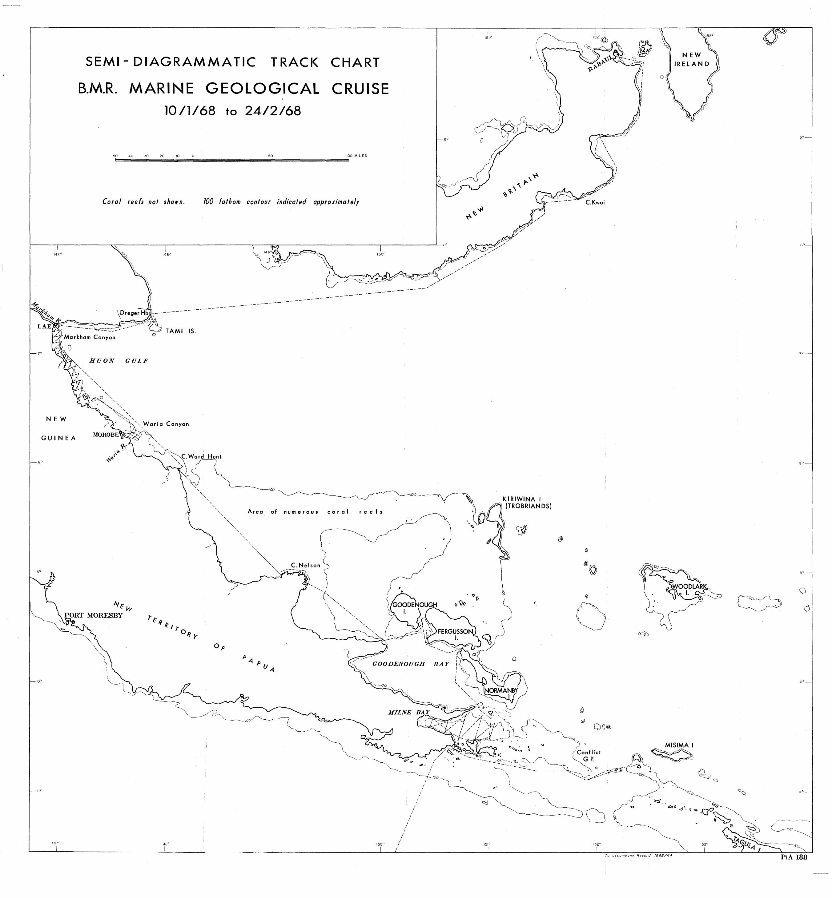
The accompanying plan illustrates diagrammatically the course of the Solomon Sea marine geological cruise.
The cruise commenced in Townsville on 10/1/68. Anchorage for the night was made inside Dunk Island. The following day, Grafton Passage was reached, and the course set across the Coral Sea for Samarai. Samarai was reached in the evening of 13/1/68, and 14/1/68 was spent in bunkering.
From 15/1/68 to 18/1/68, dredging was attempted in typical steep coral reef terrain in the vicinity of the Conflict Group. However? the extreme topography proved impossible to dredge successfully with existing light equipment, and a dredge and considerable amount of wire was lost. In addition, echo-sounding facilities proved inadequate in such terrain. The slow chart speed of the Furuno caused the fore-reef slopes to appear almost vertical.
Because of these limitations, a decision was made to return to Samarai. An appraisal of the charts indicated that the only possible areas for meaningful marine geological studies were Milne Bay, the narrow continental shelf between Lae and Cape Ward Hunt, and Rabaul Harbour.
The period from 19/1/68 to 23/1/68 was spent in carrying out a detailed bottom-sampling survey in ~lilne Bay, using the small cone-dredge.
At the termination of Milne Bay sampling, course was set for the Lae area, via Goodenough Bay. Two days, 24/1/68 and 25/1/68, were spent in attempting to sample the 700 fathom depths of Goodenough Bay. One sample was finally recovered by cone-dredge at a depth of 600 fathoms. Also, a series of dredge and grab samples were taken in sequence from the fumarole area of Gomwa Bay (Fergusson Island) out to the limit of sampling in Goodenough Bay.
The period from 26/1/68 - 29/1/68 was spent en route to Lae from Fergusson Island. Some time was spent sampling Benalla Bank, a dead coral rise seaward of Salamana. This area also proved difficult to dredge, although dead coral was recovered in one haul. Lae was reached on 29/1/68.
The ship bunkered in Lae from 30/1/68 to 31/1/68. The following day was spent by the scientific party trying to locate a suitable filler oil for the new hydrophone streamer, which was collected in Lae.
.'
..
-7-
The period 2/2/68 to 14/2/68 was spent in carrying out detailed sampling on a grid along the 3 to 5 mile wide shelf between Lae and Morobe~ a distance of 80 nautical miles. A series of sparker traverses was also made in the area~ including several ~uns across submarine canyons off the mouths of the Markham and Waria Rivers.
Bunkering and engine-room repairs were carried out in Lae from 15/2/68 to 16/2/68. On 17/2/68, the Kos II left for Rabaul p via Dreger Harbour. A day was spent sparking and dredging a 200 fathom rise between mainland New Guinea and Tami Island.
The pe~iod from 19/2/68 to 22/2/68 was spent en route to Rabaul Harbour. The whole south-facing coastline of New Britain was found to be steep-to, resulting in difficult dredging and poor sample returns.
Rabaul was reached on 22/2/68. The following day was spent in port. J. van Andel arrived on the evening plane.
During 24/2/68 a series of sparker traverses were made, in the main harbour of Rabaul and in Matupi Harbour. Following this, a sampling traverse was made from the head of Matupi Harbour into the main harbour, following the line of the sparker traverse. Grab samples and one "hydroplastic" core sample were collected.
PRELIMINARY RESULTS
Four distinct areas we+e sampled in relative detail during this cruise, each being a complete study. These were as follows:
Milne Bay (sediment samples)
Gomwa Bay (sediment samples)
Lae-Morobe shelf and canyons (sediment samples and sparker traverses)
Rabaul Harbour (sediment samples and sparker traverses)
Apart from these, routine samples were collected at every anchorage, and isolated dredge hauls were made on bank areas.
Milne Bay.
Milne Bay is a structural depression, with a water-depth of 300 fathoms, silled off from the open ocean by reef structures at the eastern extremity. The source of sediments appears to be a river system discharging into the western end, which shows evidence of deltaic out-building. Side slopes of Milne Bay are extremely steep, whilst the floor is, relatively flat •
The predominating sediment appeared to be a green lutite, becoming richer in calcareous arenaceous material to the east. A gravity core collected at a depth of 300 fathoms in the centre of the bay, although a poor sample? indicated that the lutite was underlain by a coarse sand, probably graded and therefore of turbidite origin.
•
-8-
Despite the silled nature of the bay, bottom waters appeared to be oxygenated~ and no signs of H2S were detected in surface sediments.
Gomwa Bay.
A series of grab samples were collected from the fumarole area of Gomwa Bay~ through the passage between Fergusson and Nor.manby Island. Macroscopically, these samples contained clays admixed with coarser debris, including abundant volqanic remains such as glass and pumice •
A small sample from the floor of Goodenough Bay was collected by dredge from a depth of 600 fathoms. The sample was a coarse sand, suggesting turbidity current activity in this steep-sided basin.
Lae-Morobe shelf and canyons.
A detailed sampling grid was carried out of the three to five mile wide shelf between Lae and Morobe. Samples were taken with the small "Phipps Corer", and sediments proved to be mainly green lutite, varying in composition and texture in relation to the different rivers that flow to sea in the area. Dredge hauls were attempted on some of the small bank areas that dominate the topography at the outer edge of the shelf. Despite loss of gear~ samples recovered indicated that the banks were a submerged barrier of mainly dead coral. No traces of phosphatization were evident.
The sparker survey provided much interesting data on the internal structure of the continental terrace in this region. In general, deltaic wedges of sediments occurred opposite major river mouths, exhibiting classic deltaicforeset structures. The pre-transgression land surface could be recognized, showing evidence of considerable erosion and channelling. In general, this unconformity was underlain by a thick sequence of bedded sediments of probable Pliocene-Pleistocene age, underlain in some areas by rugged basement topography.
Sparker traverses across the Waria Canyon indicated that the canyon head is entrenched up to 900 feet into horizontally bedded sediments of possible Plio-Pleistocene age.
Sparker traverses across the head of the Markham Canyon, off the ~~rkham River, showed indications of extremely rough topography, possibly formed by large-scale slumping on the steep slopel.,.. Sampling out from the mouth of the rapidly flowing Markham River indicated that most of the considerable bed-load of this river, including coarse sand, gravel and pebbles, must be discharged down the axis of this canyon into oceanic depths of the Huon Gulf. One can only conjecture as to the nature of this sediment in its final repository, but it could either be sorted by unknown processes into sandstones and conglomerates, or deposited as a bulk" sediment resembling a tillite"or perliaps-apebblymudflow. This whole problem has great geological significance, and warrants further research.
.;
•
.,"'j:
.~.
-9··
Rabaul Harbour.
The sparker traverse from the head of Matupi Harbour indicated Natupi Harbour to be of volcanic caldera origin, with several hundred feet of horizontally bedded sediments on its floor. Further seaward, towards the main harbour, a sill was crossed, showing the topography and internal structure of a volcanic rim •
Grab samples collected from the horizontally bedded sediments of Matupi Harbour were composed of blue-green lutites, largely volcanic in or~g1n. In the innermost sample, some red-colored lutite was present in surface layers. Pumice predominated the samples from outside Matupi Harbour.
Rock dredge samples.
In all but one case, when dredge hauls were successful, samples proved to be dead or living coral, showing no signs of phosphatization.
Only one sample was taken from the south-facing coast of New Britain, off Cape Kwoi, near Jacquinot Bay. This contained a worm-bored nodule which showed a reaction to the molybdate test. Unfortunately, the whole coast was found to be steep-to, with slopes of up to 450 leading into deep water, with no apparent continental shelf. Despite its academic interest, the occurrence of phosphorite in this area would be certainly non-commercial, due to the limi ted ::ta;~eal extent of water depths of less than 100 fathoms~
FUTURE WORK IN
NEW GUINEA - SOLOMON SEA AREA
From a basic marine geological point-of-view, this area must be classed as one of the most interesting in the world. It is an area of extreme but varied structural mobility, coupled with great structural relief and a tropic climate. With the addition of radar, a precision depth recorder and sui table sampling gear and a co-operative program with marine geophysics, there is no doubt that numerous valuable contri~utions could be made to marine geological knowledge, even if the work were restricted to the marginal areas of New Guinea and the islands.
From the point-of-view of marine phosphorite potentiality, it would appear from the initial survey that the areas so far surveyed are too steep-to, are obscured by Quaternary - Recent reef growth, or are flooded by abundant terrigenous material,and are therefore non-prospective. The bank ar~as sampled were invariably composed of dead or living coral,showing no phosphate enrichment.
More promising areas, which would require investigation with better equipped vessels, would be the fOllowing: .
•
..
..
-10-
Vitiaz Strait.
If the upwelling theory of phospherite formation holds, there is some evidence that the Tami Island - Vitiaz Strait - southern New Britain region would be promising. Productivity appears to be higher in this region than in the area southwest of Lae, and strong currents apparently remove all fine materialo
Trobriand Island - Woodlark Island area.
Large bank areas, as yet unsurveyed, exist in the vicinity of islands between Kiriwina Island and Woodlark Island and east of Woodlark Island. One in particular has a large area at a water depth of less than 150-200 fathoms~ and would be worthy of investigationo Productivity in the Trobriand Island region, judging by its fisheries? appears to be enh~ced.
Banks east of Rossel Island.
Poorly chartered bank areas are shown on Admiralty charts to exist some tens of miles east of Rossel Island. These would be worthy of investigation.
Solomon Island Regiono
Banks and rises are known to exist in this area, although they are generally poorly chartered.
Timing of surveys.
From experience gathered during the recent cruise, and from discussions with the master of Kos II (Capt.W.May) who has had considerable experience in New Guinea-Solomon Sea waters, it is recommended that oceanographic work in the area be restricted to those months between the northwest monsoon and the southwest trades seasons. Suggested months would be either October to December, or March-May. During these months, winds tend to be light and variable, and visibility at a maximum •
SEMI- DIAGRAMMATIC TRACK CHART
B.M.R. MARINE GEOLOGICAL CRUISE 10/1/68 to 24/2/68
Coral reefs no! shown. 100 fathom contour indicated approximately
~------~--------------~~------------~--------------------------~---.~.------------------------------r ________________ ~6° '~ """ ,," Do 1480
\~\ " tV"h'~~" """
---------------------------------------Dreger Hbr. ---------
" ~~~~~~~~--_J~_~-~-~-~-~~ ------- ~';;6 TAM I IS.
Canyon Q
HUON GULF
NEW
GUINEA
_8 0
gO
tvfw PORT MORESBY
Canyon
"
Hunt
" 100
" " "-"-"-"" Are a 0 f n u mer 0 usc 0 r a I
"-"-
"-"-" " "-" "-
"-" "-
"-"-
"-"-
"-,,- C. Nelson '\, ;"------
,,~ \
r ........ "'"" \ I "-
"-"-"-
" " "-" " " " " "-"-
Of:'
,," " b-.s'"I""5:::::'~-.C::'~' " "
)~" '. ,," ----_/ ----------
" --IOO~~-",
r e e f s
•
•
• •
o <i)o \)6
" • " "-
"-" " " --
GOODENOUGH BA Y
MILNE
" ---
" "
KIRIWINA I (TROBRIANDSj
(5 Cl
(
•
" . . <::\, '=> •
o
---
I f
f f
f f
48' f f
I f
I I
I I
f
f I
I
f f
f
/00
i i5ZO~
Q~rt=~d
0(5
,
aD<§)
Conflict Gp.
o o
- @ ~ ----,
I I I I 0 I I I I
•
~
NEW
•
MISIMA I
~
.. a::. 0 .' ~
., • 0 q. £::10 .
. ~» ...
To accompany Record 1968/44
go
<) /co ,
• 0
PIA 188