Embed Size (px)
Citation preview

In Apply j toftr Tot FO-7-1 Oc.obar 30, 1967
i, Cantury 6ffanora Manaqaaaant Corporation Attantlont Mr. Ptart S . Horvath 701 Poydras Straot Nw Orlaans. Louisiana 70139
Gantl
Rafuranca l i naOa to your I n i t i a l Plan of Exploration and Environmental Rnport raca'.vad October 22, 1987* awnndad Octobar 28, 19471 for Laaaa OCS-G 8692* niock 160* Eugana Island Araa. Thla plan tnciuoas tho act fv l t lns pr,poaad for Mailt A through E .
In accordanca with 30 CFR 250,14. ravtaa. Dueaiabar 13* 1979, anC our 1 at tar datad January 29, 1979* th is plan Is nnrnby datamlnnd ta oa coaolat* and l a aaw halng consldaraO for approval*
Your plan control nundTor la M-2632 and a Mould ba rafamncod 1n yonr Icatton and corraspondancn co* earning th is plan.
Slacaraiy your-,
(Orig. Sgd.) William H. Martfri
0 . J . Bru^navla Rag 1cm a" *w»orv1sor F la ld opa-atlona
bcc: Laasa OCS-G 8692 (OPS-3-2) (F ILE ROOM) (OPS-3-4 u/Publ lc Info. Copy of tha plan at*J ER (PUBLIC RECORDS)
AOGobarttrck 110/23/87sponcoa
HUI33H soo <ntxan fgjm I • »«

CENTURY OFFSHORE MANAGEMENT CORPORATION M FIRST NATION * l BUIlDING lb' W£ST MAIN STRUT UXINCTON tiNTUCRV *0M)7
tot.1 m * vn
MJ4 0 M sum IOUAM 701 POTDRAS ">TRl(T
N|W ORIEANS LOUISIANA H i l l MO' (5041
October 26, 1987
U. S. Dep rtment of the Interior Minerals Management Service 1201 Elmwood Fark Boulevard Nev Orleans, Louisiana 70123 2J94
Attention: Hr. Daniel Bourgeois Regional Supervisor Office of Field Operations
RE: I n i t i a l Plan of Exploration Control Nc. 2832 Eugene Isla Area, Block 160
Gentlemen:
Century Offshore Hanagemen Corporation subnjtted a Plan of Exploration for OCS-G 8692, Block 160, Eugene Island Area on October 21, 1987. This l e t t e r i s to correct a typograpSical error in Section 3 "Location of Wells'. Please change location "B" as follows:
Surface: 6500' FWL & 7000' FNL
Thank you for your consideration Jn th i s matter. I f you have any questions or comments, please contact Hs. Kathy Camp at 713'556-0607.
Sincerely,
Paul S. Horvath Executive Vice President
PSH:KC
CENTURY OFFSHORE MANAGEMENT CORPORATION W FIRST NATIONAI K'llOtNC W * O M SHUl SQUAW 167 WIST MAIN STRIt I 701 KTrDRAS MUtl I UXINGTON MNTUCKV 40S07 NfW ()Rl|ANS LOUISIANA 70IW MOI IfcOb) ?SI IK» S04 SJ«»4fcS4
U . S. Department o f the I n t e r i o r Mine raJ s Man«£. ment S e r v i c e 1201 Elmwood Park B o u l e v a r d New Or leana , L o u i a i a n a 70123-2394
October ,21, 1987
A t t e n t i o n : Mr. Daniel Bourgeois Regional Supervisor O f f i c e of F i e l d Operations
RE: I n i t i a l Plan of Exploration OCS-G 8692, Block 160 Eugene Island Area Offahore I uisiana
Gentlemen:
Enclosed p l ease f i n d n ine ( 9 ) cop iea o f tha I n i t i a l P 'an o f E x p l o r a t i o n w i t h a s soc ia ted E n v i r o n m e n t a l R e p o r t , A i r Q u a l i t y Revi f and Coas t a l Zone C o n s i s t e n c y Sta tement f o r Lease OCS-G 8692, B l o c k 160. F ( 5 ) cop iea o f the s u b j e c t r e p o r t a are f o r " P r o p r i e t a r y " i n f o r m a t i o n purposes and f o u r ( 4 ) cop ies c o n t a i n " P u b l i c I n f o r m a t i o n " ; a l l cop iea be ing marked a c c o r d i n g l y .
E x c l u d e d f r o m t h e P u b l i c I n f o r m a t i o n c o p i e s a r « c e r t a i n g e o l >gic d i s c u s s i o n s , dep th o f w e l l s and s t r u c t u r e map.
Century O f f s h o r e Management C o r p o r a t i o n proposes o p e r a t i o n s t o commence by December 1, 1987. Should f u r t h e r i n f o r m a t i o n be r e q u i r e d , p lease c o n t a c t Ma. Kathy Camp, o f J . Connor C o n s u l t i n g at 713/558-0607 .
PSH:KC:bna
e n c l o s u r e s
"Public

I
I • COASTAL ZONE MANAGEMENT. I •
/ CONSISTENCY CERTIFICATION
INITIAL PLAN OF EXPLORATION
EUGENE ISLAND AREA, BLOCK 160
OCS-G 8692
The proposed a c t i v i t i e s described i n d e t a i l i n t Plan comply v i t h Louisiana's approved Coastal Zone Management Program and - i l l ba conducted i n a manner consistent v i t h such Program.
Arrangements have been made v i t h tha State-Times in Baton Rouge, Louisiana, to p u b l i s h notice of the proposed a c t i v i t i e a no l a t e r than October 26, 1987.
Century Offshore Management Corp. Lessee or Operator
C e r t i f y i n g o f f i c i a l
October 21, 1987 Date

INITIAL PLAN OF EXPLORATION
EUGENE ISLAND AREA BLOCK 160
I I OCS-G 8692
Century Offahore Management Corporation as operator of the subject block, submits thia proposed I n i t i a l Plan of Exploration ln accordance with the regulations contained within Tit l e 30 CFR 250.34 as follows:
1. Schedule of Operations
In order to delineate the hydrocarbon potential and limitations of this block, Century Offshr anagesent Corporation proposes to d r i l l f i v e (5) wells in Eugene Isla> -rea Block 160.
The f i r s t well w i l l be spudded on or about December 1, 1987, subject to the approval of t h i s Plan of Exploration and issuance of the required Permit to D r i l l . Wells A thru E should each take approximately 30 days to d r i l l . The epud dates for the remaining wells have not been scheduled; however, exploratory d r i l l i n g should be completed by April 30, 1988.
I t should be emphasized that this schedule is tentative in the meaning of 70 CFR 250. 34-1(a). Additional exploratory d r i l l i n g must be predicated upon the need to further define structures and/c reservoir limitations. In addition to the d r i l l i n g of the well(s), other a c t i v i t i e s which may be conducted under t h i s Plan would be the setting oi a well protector structure, a seafloor template, a velocity survey ln a wellbore, and soi l borings.
Transportation from the existing onshore f a c i l i t i e s in Intracoastal City, Louisiana, to Block 160 w i l l Involve the use of one supply boat making 3 trips per week, one crew boat making 5 tr i p s per week, and one helicopter making 7 t r i p s per week.
2. D r l l l i n g Equipment
Depending on the a v a i l a b i l i t y of rigs, the proposed wells w i l l be d r i l l e d with a cantilever jsck-up d r i l l i n g r i g . Typical diverter and BOP schematics are enclosed herewith as Attachment I .
Safety features w i l l Include well control and blowout prevention equipnip-it as described in OCS Order No. 2. The appropriate l i f e rafts, l i f e :kets, ring buoys, etc. as prescribed by the U.S. Coast Guard w i l l be maintained on the f a c i l i t y at a l l times.

Location of Welle
The approximate locatlona of the f ive (5) ve i l s proposed ln thie Plan as ve i l as theli proposed depths, are shovn on bhe accompanying Location Plat , enclosed herewith as Attachment I I , andjare described as fnl lova:
/ • TOTAL DEPTH "A" Surface: 6500' FWL I 5300' FNL
•B- Surface: 8600' FWL I 7000' FNL
•C- Surface: 6500' FWL & 5300' FNL
•D" Surface: 6500' FWL £ 5300* FNL
"E* Surface: 6500' FWL I 5300' FNL
Water depth in thia block ranges from 68-76 feet.
Geoiogical/Geophye :al_Informatlon
A structure map which Illustrates. Century Offahere Management's current interpretation of Eugene Island Block 160 i s enclosed herewith as Attachment I I I .
« A Shall • D r i l l i n g Hazards Report covering the surface location of the vellB propoaed ln this Plan la enclosed herevith aa Attachment IV.
Archaeological_Informat ion
An Archaecloglcol Survey vas required vith the Shallov Hazards Survey Report for Eugene .land Block 160. I t has been determined that there nre n magnetic ano alles or r u l t u i a l resources within 700 feet of the proposed well location.
Onshore.Facilities
The service base for this area will be intracoastal City , Loulalana. This vi1J be an established f a c i l i t y that v i l l i quire no modifications.
Pollution Pievention Information
Pollution pievention control measures wi l l be in accordance with OCS Orrim |n, 7. fentuiy Off shot f Hanagemer \ has on f i l e with the MM? ar. Oil S p i l l Ct«fitmfSH > Plan foi Ihe Oulf of Mexico In the event of a s p i l l .

this Plan v i l l be actuated. Century Offahore Management ia a member of Clean Gulf Associate? vhlch provides s p i l l containment equipment and clear up equipment at six Halliburton Service Bases on the Gulf Coast:
1 I ' Galveston/and Rockport in Texas; Grand Isle, Venice, Cameron, and Intracoastal City in Louisiana. If a s p i l l should occUr from the propoaed operations, the equipment located at Cameron, Louisiana vould be utilized first, vith additional equipment moved in from other bases, i f necessary. Fast boat response vith o i l boom, skimmers, pump and storage tanks vould require approximately 10-12 hours, Including preparation time. A heavy equipment system response vould require approximately 20-26 hours, including six hours preparation time.
Drill cuttings and excess drilling fluids v i l l be disposed of in accordance vith applicable environmental regulations. Tbe drilling fluid components and additives to be used are enclosed herewith as Attachment V.
Encloaed aie copies of the fjlloving information:
ATTACHMENT NO.
I Rig Information II Location Plats (Well & Vicinity) II I Structure Hap IV Shallov Drilling Hazard Report V List of Mud Components and Additives
Also enclosed are the associated Environmental Report, Air Quality Reviev and Coaatal Zone Consistency Statement for Louisiana.

a. SKArrrt A*SJ LM m m m too: rsi *u* ?. CA .if.Os I t l b 11 VAivf ?OD0 K\ ASSY." #6i?o^-7-n i e t U i Axuetor #1-302.> jar .
MVl f t lH WD7C NMCIS: f i n riOOJ-WM»nowi t»M ••?».• OA IPt'i iv^nm Ofrit(.io?".ii HOMI MDGAfcC-]
N O l f f i V l R U R VALVIS N?1 DtSlGNLO 1 0 W t K A U 1 I C A l l Y
in r», M nf.iHfi rv . » H par vr r i.
I

BOP STACK
I
CHOKE SIDE FRONT VIEW
EQUIPMENT LIST
. u -s / r .5,00: rii tuntftM n t i -o mean f.o.t.
. 13-S/8'-lO.Oi'C ril CfftttOftJ DDJLlC UMT IfW *U' I.O.T.
. l j . s / r - i o . o . : rsi CV.'PCIN S!M:L( UMT Ttn »r i.o.r.
. 1-1/u-.u..o.'f- ru caftftON siur::; WWl i n K/tMM *•!•>: t«
. 3 - i / U - H . ( ' ' I 1 (atttftflf m i C*'C» VAi V! K/b> M i MftS C !
3 l / H U . d I I ('.''lir.'. U I I 'I HtMMr.H Ot|»M(n | f |V| kf t» l i t 1 « . ' •• .1
I

Block 160
Century Offshore
Eugene Island loO VICINITY MAP
•3

Y= 66.912 46
cc • <? CO r' m cc
i i
X
6500
Proposed Surfacc Locat ions A.C.D&E
- * o Proposed Surface
Locat ion B
BLK 160
1 N
Y * 52 .4 13 88
'Vui:.\ Enformation"
CENTURY OFFSHORE MANAGEMENT CORP
EUGENE ISLAND BLOCK 160 OCS G 869?
OFFSHORE LOUISIANA
Pl AN OF EXPLORATION
II
i ' 000
im 0 2 0 0 0 '
I 4G0 ' i

SHALLOW DRILLING HAZARTS
EUGENE ISLAND BLOCK 160 OCS Q
Eugene Island Block 160 haa baan examined for shallow d r i l l i n g hazards . Descriptions of tha geophysical instrumentation and the navigation systems u t i l i z e d In the survey w*re submit t»*j October 7, 1987 for your review md approval.
Two high raaolution geophysical aurveys conducted within Eugene Island Block 160 were u t i l i zed f J X thia report. The hazard survey materials ware reviewed by Ma. Laura L a n d r y , Archaeologis t and Nr. Wi l l i am K. Murphy, Maiine Geophysicist of Gul f /At lan t i c Geophyaical As j c ia tea . Ma. Landry'a review was designed to locate and define aitea of possible prehi&'.oric habitation. The Cul tura l Reaourcea Asreaamenv indicataa that no high probability areaa for prehistoric archaeological a i t a j associated with formerly subaerially exposed landforms are within the survey area.
Mr. Murphy reviewed tha hazard data for evidence of ahallow d r i l l i n g hazards. "Bright Spots" de l inea ted by the sparker and water gun se ismic data are outlined on tha Anomaly Map. The magnetometer recorda ver i f i ed the ooaition of the abandoned wal l in thia block. Fi t ty-nine (59) magnetic a.u.va> lea were recorded, with most occurring in the v i c i n i t y of the previous ve i l a i t a . These areaa w i l l bs » cided during propoaed and any future d r i l l i n g rperationa.
Century Offahore Management Corporation haa reviewed the art ..aac .logical and multi-aensor engineering survey report co loucted by Gulf/AtJo »* c Geophysical Associataa. Both aurfaca locationa are located on Li.ie 7 I cf. the John E . Chance Survey. concur with the conclus ions and reccm.nendat ions by Gul f /At lant ic Geop; y s i c a l Associates that tha preaently propoaed d r i l l i n g locationa are free and clear oi! ahallow hazards
In view of tha foregoing, we believe th .t X .\- ^rpoaed wall can be d r i l l e d with minimum hazard to paraonnal and sc. tprjspi n. accordance with Minerals Management Service regulations.

G U L F ' A T L A N T I C G E O i * K Y * ? C A L A S S O C I A T E S
William K. Murphy
13 Yoseml*> Drh e
11 Ntw Orleai I I A rVoi31
4 (504) J93 O B V .
October 16, 1987
Mr . Paul S. Horvath Century Offshore Management Corporat ion 382U One Shell Square 701 Poydras S t ree t New Orleans, LA 70139-3801
Dear Mr. Horvath 1
F u r t h e r to my l e t t e r o f September 30, 19&7» forward ing to you t he Archeological and Multi-Sensor Engineeri-ig Report on Block 160, Eugene I s l and Area, I have reexamined the survey data f o r a second proposed d r i l l i n g l o c a t i o n tha t you wish to include i n the plan of e x p l o r a t i o n .
T h i s second proposed l o c a t i o n , i n approximately 7 l i f e e t of wa te r , is located 1700 t et south o f your primary l o c a t i o n at a p o s i t i o n 7000 f e e t f *„m the nor th l i n e and 6500 f e e t from the west l i n e of the b l o c k .
T h i s reexamination o f the data supports the o r i g i n a l i r . ^ r p r e t a t i and indicates t h a t t h i s proposed l o c a t i o n i s f r e e and t ' l t fcr of sha l low hazards.
I f we can be o f f u r t h e r service p lea : - ) donot hes i t a t e to c a l l .
v e r y t r u l y yours,
GULF/ATLANTIC GEOPHYSICAL ASSOC ATES W i l l i a m H. Murpry, President

P M I . L T *
COMMON CHEMICAL C ' CHEMICAL 1 1 TRADE NAME
Aluminum Stearate "AXTAFLO-S" Barlte Calciua Carbonate Calciua Chlordi » Calc iua Oxide Calciua Sulfate Carboxyaethyl C e l l h Cauatlc Potaah Cauatlc Soda Chroae Lignite Chroae Lignoeulfonete D r l a l i r g Detargent • E - P a l '
Farrrchroae Llgnoaulfonate Ce l
Gypsum Lignite Lignoeulfonata -Mud Sweep" •MQR-REX" •Shale-Trol-Sapp Soda Aah Sodiua Bic*i r" ?i ate l i r i iua CtrNjai meth- 1 Cel luJ-ee skx». i a Chloi Ldv
• 4 -.4 Chromate St a. oh •YX-.010-• TORO TrJ -.-O l f C a .v«gi 'Bimck Mapi Supers:* * aliMafl
•Jelf lake" MICA "Pipe-Las* •Wall-Muf Wood Fibera
•uT COMPONENTS
I PESCMPT/i K . ' J F .MATERIAL
i
Aluminum Stearate Nonlonic Surfactant Barium Sulfate (BaSo4) A r agon**. CaCcl) HydrcphiMf* <CeC12> Lime (Oulc«> Anhydrite fuaS04> Carbr-,aethyl Celluloee Fotaajluai Hydrate Sodij* Hydroxide (NaOH) Chroae L I O M U
Chroae Lxgnoeulionate Soap Don-toxic, biodegradable defoamer Derived froa wood pulp Sodium rontmorlllonite, bentonite, attapulgite CaSo4.?H20 Lignite Llgnoaulfonate Cement rre-flueh Hydrcloyzed Cereal aoi*-Hrgano-aluminum complex Solium Acid Pyruphoaphat.-Sodium Carbonate NaHC03
Sodium Carboxyaethyl Celluloee NaCl NaCr04. 10H20 Corn Starch Biodegradable drilling lubricant biodegradable drilling lubricant O.U baae ;ud cone. Sacked concentrated oil baae aud Used to v < certain loaa-circulatlon p l l . . Plaatic fo i l , .-hredded cellophane Loss-circulition mater A -I rurfrctar.< e.'xed with dieael Grcund ••ftl.tel ahelJa Loaa-clrcuiatio' eat»;lal

ENVIRONMENTAL KFPORT
FrTHRAL LEASES OCS-G 8692 EUGENE ISLAND ARE*., B'.CCK 160
CFFSHORt IBERIA, ST. MARY khd TERRE*J II PARISHES, LOUISIANA
r.~ FOLLOWING ENVIRONMENTAL REPORT VAS PREPARED BY J. CONNOR CONSULTING FOR • /rn.URY OFFSHORE HANAGENEKT CORPORATION FOR COASTAL ZONE CONSISTENCY L L*» .RMINATION »Y THE STATE OF LOUISIANA ON OPERATION PROPOSED T0 BE CONDUCTED IN Tk£ INITIAL PLAN OF EXPLORATION FOR LEASE OCS-G 869:,. FOR XHOl'IRTES REGARDING THIS REPORT PLEASE CONTACT:
CENTURY OFFSHDRE MANAGEMENT CORPORATION
701 POYDRAS, SUITE 3824
NEW ORLEANS, LOUISIANA 70139
ATTENTION: MR. J. P. SLATTERY
OCTOBER, 1987

TAELE QF_CDNTENTS
m i l »*ps I ' i
TABLF OF CONTENTS j | ' i i
I . DESCRIPTION r ? C r t # U ACTION 1
A. DE5,RlPTiC* P» PROPOSLD TRAVEL NUDES, ROUTES AND 1 FREQUENCY
B. ONEHORF SUF -f.T SYSTEMS 1 C. NEV C- U N U S J A I \*CHNOLCGY 1
D. viciNii : HA:» I E. PROPOSED HL/.NS 'IC .-ANSPTf OIL AND G/iS TO SHORE
ROUTES, OUANTITIFS
I I . DESCRIPTION OF AFFECTED cJNVIRONHt *T 2
A. COMMERCIAL FISHTNG 2 B. SHIPPING 2 C. PLEASURE BOATING, SPORT FISHING AND RECREATION 2 D. POTENTIAL OR KNO'N CULTURAL RESOURCES 3 E. ECOLOGICAL Li f L'NSITIVE F EATURES 3 F. PIPELINES ANT CABLES 4 G. OTHER HIMERAL USES 4 H. OCEAN DUiv ING 4
ENDANGrRCD OR THREATENED SPECIES ANC CRITICAL 4 HABITAT
I I I . UNAVOIDABLE ADVERSE ENVIRONMENTAL EFFECTS 6
A. WATER OUALITY 6 B. EFFECTS OF MARINE ORGAN I ISMS 6 c *>:TLANDS AND BEACH e D. A I R OUALITY 6 E. COMMERCIAL FISHING 6
SHIP NAVIGATION 7 G. CULTURAL RESOURCES 7 H. RECREATION AND AES" ^ETIC VALUES 7
IV. SUMMARY 6
n'tTFRENCES 9
LI£TT OF ATTACHMENTS
1. VICINITY MAF
11-

DESCRIPTION OF PROPOSED ACTION
Century Of f shore Management Corporat ion (Century), plans to conduct (exploratory a c t i v i t i e s on Eugene Is land Area Blbck 160, OCS-G 8692.
As'p. : posed, the I n i t i a l Plan of Explora t ion fo r Eugene Is land Area Block .60 inc ludes d r i l l i n g f i v e (5) v e i l s i n Block 160.
At th la t ime, planned commencement date f o r d r i l l i n g the f i r s t v e i l l n Block 160 i s on or about December 1, 1967.
A. DESCRIPTION OF PROPOSED TRAVEL MODES, ROUTES AND FREQUENCY:
Boats and h° : oters v i l l be dispatched from support bases located ln Intracoa"* 1 >'ity, Louisiana. The boats v i l l normally move t o Block 160 v i3 the moat d i r e c t route from In t r acoas t a l C i ty , Louisiana. Fol loving i s an estimate of boat and he l icop te r t r i p s to the proposed operations on Eugene Island Block 160.
D r i l l i n g Operat-one
Crew Boat 5 t r i p s per veek Supply Boat 3 t r i p s per veek Hel icopter 7 t r i p s p^ veek
B. ONSHORE SUPPORT BASE
The proposed a c t i v i t i e s w i l l u t i l i z e a support base located at In t r acoas t a l Ci ty , Louisiana. This base provides 24-hour service , a radio tover wi th phone patch, dock space, o f f i c e space, parking l o t , equlpme t and supply storage space, d r i n k i n g and d r i l l water, etc. These proposed exploratory a c t i v i t i e s v i l l help to maintain t h i e baae at i t s pree?nt l eve l o f a c t i v i t y . No expansion of the physical f a c i l i t i e s or the c rea t ion of nev jobs i s expected to r e s u l t from the vcrlc planned in con junc t ion v i t h Block 160.
C. NEW 0?\ UNUSUAL TECHNOLOGY
No new techniques or unusual technology w i l l be required f o r these operations.
D. VI [ l i f t HAP
See Attachment 1.
E. REPOSED MEANS TO TRANSPORT OIL AND GAS TO SHORE, ROUTES, QUANTITIES
\ I p roduc ib le hydrocarbons are found they are l i k e l y to be v.-ansported to shore through connections wi th p ipe l i ne s already i n plac* in or near Eugene IslanC Block 160.

I I . DESCRIPTION OF AFFECTED ENVIRONMENT
A. COMMERCIAL FISHING 1 J I 'Thtf Gulf fishery le dominated by the shell fisheries: shrimp, crabs, and oysters (vith smaller amounts of clam's and scallops). The shrimp fishery ln the Gulf area Includes brovn, white, and pink shrimp. These are taken almost exclusively by trawl fishing depths ranging from 2 to 73 meters. Eugene Island Block 160 is located within the major f i n f i s h grounds, white and brown shrimp harvest areas and the high density offshore shellfish areas. Finfish volume for the Gulf states i s dominated by menhaden. Menhaden are number one ln volume and second ln value for Louisiana. Gulf Region landings in 1965 vere 1.9 b i l l i o n pounds, or 70X of the 2 b i l l i o n pounds U.S. menhaden catch, most of vhlch i s landed at Louisiana ports (Fisheries of the United States 1985, April 1986.). Other flnfishes which contribute significantly to Louisiana's landings Include drum, catfish, sea trout, mackerel and anapper. (Louisiana Landings for Specified Periods, 1984 and 1985).
Since the majority of shrimp and commercial bottom fish are caught by trawling, sites occupied by d r i l l i n g rigs must be avoided by ahrlmpers, but are attractive to hook and line fishermen.
B. SHIPPING
Eugen Island 160 is clear of a l l shipping fairways and anchorage areas. The d r i l l i n g r i g and each of the marine vessels w i l l be equipped with a l l U.S. Coast Guard required navigational safety aids. There should be l i t t l e or no Impact on shipping resulting from the proposed operations.
C. PLEASURE BOA NG, SPORT FISHING AND RECREATION:
Sport fi s h i n g in Louisiana i s a very popular form of recreation. Louisiana's coastal marshland with few roads reaching the shoreline has limited fishing access and precludes f u l l u t i l i z a t i o n of the saltvater fishery resources. Nevertheless, a high percentage of Louisiana residents ovn or have excess to boats. Sport fishing around offshore o i l and gas rigs is popular. Results of recreational fisheries surveys by Ditton and Graefe (1978) in the northvestern Gulf of Mexico's Houston-Galveston area indicated that only one-third of the boating population vas saltvater fishermen and enly 5% fished offshore. Hovever, o i l and gas structures attracted ~ore l i s h i n g than any other structure, natural or a r t i f i c i a l (87X of the boats and 50*/. of a l l offshore recreational fishing e f f o r t were directly associated vith o l i snd gas platforms). Offshore fishermen were estimated to have contributed over five million dollars to the local economy. (The Ecology of petroleum Platforms ln the Northvei 'ern Gulf of Mexico; A Community Profile).
Boating i n Louis iana 's coas ta l areas i s most o f t e n re l s t ed to r recreaLional f i s h i n g . Water s k i i n g and s a i l i n g are growing i n popu la r i ty , especia l ly i n es tuar ine lakes near South Louisiana 's
I (major urban centers. f
'Hunting i s a popular rec ree t io r .a l a c t i v i t y irf Louisiana. A v a r i e t y of water f o w l are taken throughout the coastal marshes. There are three s t a t e w i l d l i f e refuges and numerous s t a te and federa l b i o l o g i c a l l y sens i t ive land areas onshore irom the area of operation.
With the exception of Grand I s l e and v i c i n i t y and a s t re tch of beach area i n Cameron Parish, (Peveto/Constance/Oceen View Beaches, Hol ly Beach, Hackberry Beach) Louisiana haa very l i m i t e d beach area sui table f o r recrea t ion . Host o f i t i s very narrow, of poor r ec rea t iona l q u a l i t y and gene ra l ly inaccessible by automobile, some of the h ighes t qua l i t y beach areas in coastal Louisiana are found along the b a r r i e r islands chain o f f Terrebonne Parish.
Several a d d i t i o n a l s i g n i f i c a n t recrea t iona l resources are found along the Gulf Coast. Louisiana has ornamental gardens, scenic roads, r i v e r s , and t r a i l s . Nc adverse Impacts are an t ic ipa ted .
D. POTENTIAL OR KNOWN CULTURAL RESOURCES
Eugene I s l and 160 l i e s ins ide the Cu l tu ra l Resource S e n s i t i v i t y Demarcation Line (USDI, 1979, Visual 1), and the re fo re , f a l l s i n an area where c u l t u r a l resources are l i k e l y to be found. An arciiaeo-logic 1 survey was required f o r Eugene Island 160, no evidence of archaeological features were seen i n the data presented. However, Century agrees that i f any s i t e , s t ruc ture , or ob jec t of h i s t o r i c a l or a rchaeological s i g n i f i c a n c e should be discovered during any operations, the f i n d i n g w i l l immediately be reported to the Regional Director and every reasonable e f f o r t w i l l be made to preserve and protect the c u l t u r a l resource from damage u n t i l the Regional Director has given d i r e c t i o n s as to i t s preservat ion.
E. ECOLOGICALLY SENSITIVE FEATURES
There are no areas of p a r t i c u l a r concern w i t h i n Eugene Island 160. However, there are several areas of environmental concern that l i e onshore from the lease s i t e . These Include (1) Sabine Pass Lighthouse State Commemorative Area, (2) Paul J. Ralney W i l d l i f e Refuge, (3) Rockefel ler State W i l d l i f e Refuge, (4) Louisisna State W i l d l i f e Refuge, u>d (5) Ruther ford Beach State Park and other recrea t ional beaches.
Clean Gulf Associates has prepared and distributed to members, maps of the coastline of th? Gulf of Mexico l i s t i n g environmentally sensitive areas onshore and near-shore which might be affected by an accidental hydrocarbon release. I
Since'the entire coastline of the state of Louisiana can be considered environmentally sensitive in varying degrees, there is no benefit seen ln l i s t i n g a l l the major bays ana w i l d l i f e refuges along the coast. No adverse impacts are anticipated.
F. PIPELINES AND CABLES
There are no pipeline or cables traversing Eugene Island 160.
G. OTHER MINERAL USES
The a c t i v i t i e s proposed for Eugene Island 160 v i l l have no direct or indirect impact on other mineral uses.
H. OCEAN DUMPING
Ocean dumping i s prohibited ln this area.
I . ENDANGERED OR THREATENED SPECIES AND CRITICAL HABITAT
Five federally listed endangered whale species occur v i t h i n the Central Gulf. These include f i n , humpback, right, sei, and sperm vhales. Generally, these large cetaceans inhabit the continental slope end deep oceanic vaters, occasionally they are Bighted nearshore (Schmidly, 1981). Sperm vhales have been sighted near the Louisiana Delta and offshore Brovnsville ( F r l t t s et al . , 1983).
Red wolf hybrids occur along the Gulf coast in Cameron Parish, Louisiana and Jefferson County, Texas, for a l l practical purposes, pure-blood red wolves are extinct in the wild (McCarley and Carley, 1979).
Four federally listed endangered t u r t l e species (Kemp's ridley, green, hawksbill, and leatherback turtles) and one threatened species (loggerhead t u r t l e ) occur in the Gulf of Mexico.
The American alliga t o r occurs generally throughout the Central Gulf coastal areas. The alligator i s listed as endangered throughout i t s range except in the coastal areas of Florida and Texas where i t i s listed as threatened and in Louisiana where i t ie li s t e d as •threatened by similarity of appearance".

The red-cockadea woodpecker occurs p r i m a r i l y i n nature open pine forest throughout the Eastern and Central Gulf area and i n t o eastern Texas. |
Arctic peregrine falcons migrate along the eastern coast of Florida, the Florida Keys, and the Gulf coast of Texas. Some peregrine falcons overwinter along the Gulf coastal areas.
The endangered eskimo curlew's northward migration corridor crosses the Louisiana and Texas coastal areas.
Brown Pelican's occur along the coast of Cameron Parish, Louisiana. Bald eagles i n h a b i t several Gulf coastal counties.
These species may be affected by the development of coastal lands and/or the occurrence of o i l s p i l l s which may a f f e c t the species d i r e c t l y or through t h e i r food sources. Since the proposed a c t i v i t i e s i nclude no plans f o r the development of the coastal lands, the impact on endangered or threatened species i s p r i m a r i l y based on the occurrence of o i l s p i l l s .
On pages I I I - 5 through II1-72 of the Final Environmental Impact Statement f o r OCS Sale No. 47 there i s a discussion of the factors for estimating the sig n i f i c a n c e of o i l s p i l l s and t h e i r impacts. The impacts on various endangered and threatened species w i l l depend on the nature of the s p i l l , weather conditions, proximity of s p i l l to species, tolerance f o r o i l of species, and the response time and effectiveness of the o i l s p i l l cleanup and containment servies. Given these v a r i a b l e , the impact on the various endangered or threatened species w i l l vary from l i t t l e or no e f f e c t to serious.
The experience of o i l ana gas exploration i n the Gulf of Mexico indicate that there i s a small p r o b a b i l i t y of an occurrence of an o i l s p i l l . The Draft Environmental Impact Statement (DEIS) fo r OCS Sale A-62 and 62 indicates on page 71 that "the aggregate 15 year s o i l l rate i s .0009 percent of the t o t a l volume produced". Table 7, page 73, of the DESI indicates t h a t there has been only 30 incidents of o i l s p i l l s f o r t:.ie 15 year period. The p r o b a b i l i t y remains low because of t h r l e v e l of technology used by the o i l and gas industry to insure safe and responsit e operations.
Century as a prudent operator, w i l l takt the necessary measures to reduce the p r o b a b i l i t y of o i l s p i l l s . wentury's proposed exploratory operations on Block 160 should pose no threat to any endangered or threatened species.

DK ABLE ADVERSE ENVIRONMENTAL EFFECTS
HATER OUALITY
I I D r i l l i n g a c t l v l t l e a / v ' i l t empora r i l y reduce water q u a l i t y adjacent to the l o c a t i o n . This w i l l increase t u r b i d i t y l n a plume down-current from the work e l t e . Released waters and a minor o i l s p i l l ;ould a l so con t r ibu te to water q u a l i t y degradation. EFFECTS ON NARINE ORGANISMS
jome organisms w i l l be k i l l e d and eon.e w i l l be temporar i ly f u n c t i o n a l l y impaired as a r e s u l t of exploratory operat ions. The ROE * a f f e c t e d groups w i l l be p lankton ana benthos immediately around the d r i l l i n g r i g . Damage w i l l be both mechanical and t o x i c o l o g i c a l . discharge o f hole cut t ings w i l l damage plankton wl th l r . the plume and jury some o f the less mobile ben th ic fauna. These Impacts are :onsidered t o be local ized, sho r t term and r e v e r s i b l e at the jopulation l e v e l .
\n o i l s p i l l could a f f e c t a broad spectrum of marine organisms, lowever. most e f f e c t s would be l o c a l i z e d and short term. Any effects on mammals and t u r t l e s would be s i g n i f i c a n t .
IETLANDS AND BEACH
n the u n l i k e l y event of a s p i l l occurr ing and reaching shore, irganisms i n wetland and beach hab i t a t s could be k i l l e d or unc t iona l ly impaired. Human community d i s r u p t i o n ~ould also occur, lthough a l l such e f f e c t s would be loca l i zed , any e f f e c t s on ndangered species and/or c r i t i c a l habi ta ts would be s i g n i f i c a n t .
IR OUALITY
he a i r q u a l i t y at the lease s i t e w i l l be degraded temporar i ly uring opera t ions , but should r e t u r n to normal once operations are easurably completed. Offshore a c t i v i t i e s probably w i l l not a f f e c t nshore a i r q u a l i t y . Air q u a l i t y at tne onshore base w i l l be only n a i g n i f i c a n t l y reduced by onshore a c t i v i t i e s . Any such c i f e c t w i l l e temporary.
OHHERCIAL FISHING
f the v a r i o u s types of f i s h i n g gear i n use i n the OCS areas, t r awls ave the g rea t e s t chance f o r ope ra t iona l c o n f l i c t s wi th o i l and gas c t i v i t i e s . Losses may, however, be compensated under the iahermen'a Contingency Fund or other legal routes. Trawl nets can e snagged on underwater stubs causing damage or loss of the nets, n add i t ion , l t i s conceivable t ha t snags could damage underwater roduction equipment of p i p e l i n e s causing a s p i l l of o i l O' gas.

Because s s f e t y equipment i s i n s t a l l e d , which shuts l n production when a loss of pressure occurs, the l i k e l i h o o d of e major s p i l l r e su l t ing thereby i s considered very small . iLess f r e q u e n t l y , lsrge
I objects which were los t overboard from petroleum indus t ry boats, ' p ipe l ine lay barges, and p l a t fo rms are caught by f i s h i n g gear
r e su l t ing i n damage to the gear and/or i t s catch of f i s h ; however, occurrence of t h i s type o l i nc iden t i s low. Also, commercial fishermen would probably not harvest f i s h i n the area of an o i l s p i l l , as s p i l l e d o i l could coat or contaminate commercial f i s h species render ing them unmarketable. Other unavoidable adverse impacts i nc lude loss of f i s h space caused by i n s t a l l a t i o n of unburied p ipe l i ne s , r i g s , p lo t fo rms , or by other OCS-related 3tructures. There may be some loca l i zed compet i t ion f o r shore i a c i l i t i e s . These e f f e c t s and any e f f e c t that the explora tory operations w i l l have on stocks of important species e^e considered minor.
F. SHIP NAVIGATION
Very l i t t l e i n t e r f e rence can be expected between the r i g end marine vessels u t i l i z e d during d r i l l i n g operations and ships tha t use established fa i rways . However, at n ight and during rough weather, fon.. and heavy seas, ships not using establ ished fa i rways could
v-i h the r i g .
S JURLES
There i s only a small p r o b a b i l i t y tha t an unknown c u l t u r a l resource exis ts i n the lease area.
H. RECREAT:ON
The r i g may represent an obstacle to some sport fishermen, but such an effect i s expected to be negligible and not oermanent.
Even thoug.i existing regulations and orders prohibit indiscriminate l i t t e r i n g of the marine environment vi t h trash, offshore o i l and gas operaticns involving men, machines, equipment, and supplies is bound to result in some l i t t e r i n g of the ocean. Human nature and accidents associated vith offshore operations v i l l contribute some floatable debris to the ocean environment vhich v i l l eventually come ashore on major recreational beaches.
The effects that no, rr.al operatic.-.*- a minor o i l s p i l l would have on any f i s h stocks important to sport fishermen are also considered to be nerjl
A minor i < - non-petroleum floating debris could foul beaches 1 ''ase area. The fouling of the beaches would be an aest V. that could adversely affect recreation. Any effects un be«ui. .tcreatior. could adversely affect tourism and, consequently, the lc~al economy.
-7-

I
IV. SUMMARY
The proposed a c t i v i t y v i l l be carried out and completed vith the guarlantee of the following items. |
A. The* best available and safe3t technologies v i l l be Mlized throughout the project. Thie includes meeting a l l .tpplicab ,e requirements for equipment types, general project ltyout, safety systems, and equipment and monituring systems.
B. All operations are covered by a Minerals Management Service approved Oil S p i l l Contingency Plan.
C. All applicable Federal, State and Local requirements regarding air e...ission and vater quality and discharge for the proposed a c t i v i t i e s , as veil as any other permit conditions, v i l l be complied with.
D. Tne proposed a c t i v i t i e s described in det s i l in the Plan of Exploration v i l l comply v i t h Louisiana's Coastal Management Program and v i l l oc- conducted in a manner consistent v i t h such Program.

REFERENCES
I 1. Flyialj_Envlronmental_Impact_St atement, Propoaed Oil and Pas Lease Salea
94, 9 and 102, Gul:T~oT Hexlco OCS Region, OCS EIS, HMo 84-0057.
2. Final Envi ronments Impact Stateaent, Proposed Oil and Gaa Leaee Sales 94, 98 and 102, GL-. of Mexico OCS Region, OCS EIS, HMS 84-0057, visuals.
3. Fisheries, of_the_United_States, 1985, April, 1986.
4. The_ Ecology of Petroleum Platiorms_ln_the_Northtte^ern_Gulf of Hexlco: A Community__Proflie, Bureau of Land Hanagement f l i e Report 82-03, July, 1982.
5. Environmental Report West Cameron Area_Blocks 516 and 524, Harch, 1987.
r3. BLf. D af t_£nvironmental_Impact. Statement, OCS Oil and Ges Lease Sales A-f>2~ar.d 62. "
7. BLM Flnal_Envlronmental Impact Statement, OCS Oil and Gas Lease Sales A-62 and 62. "
8. BLM Final Environmental Impact Statement, OCS Oil and Gas Lease Sale 47.

tuv i« Island 160 VICINITY m*9
0 *0_ .

P.O.'Box i?1*<>3> Houston. Texa: 772 .8 713-558-0607
FRQJECTED AIR EMISSION SCHEDULE FOR EXPLORATION PROJECT
CENERAL INFORMATION
Locution of F a c i l i t y :
Distance Offahore: Nam.? of Rig: Operator:
Contact Parson: Veil Footage to be Dri l led ln 1967: Well Footage to te Dri l led ln 1988 Date D r i l l i n g Wil l Begin:
Eugene Island 160 OCS-G B692 63 a l l ea Typical canti lever jackup Century Offahore Hanegeeent Corp. 701 Poydras, Suite 3824 Nev Orleans, Loulalana 70139 Nr. J . P. Slattery 8600' 39, 950' December 1, 1987
HAJOR SOURCE (OFFSHORE)
Pover taed aboard d r i l l i n g v a c e l ; approximate footage d r i l l e d 48,550'. •
Projected Fmissions Pr ojacted Emaaione Laitted due/day ;r tone/year (1be/day) ••tone/year Suoatance 1382-" 1983
CO (114) 1.70 (126) 7.55 SO
•J (36) .34 (40) 2. 40
m NOx (533) 8.00 (59D 35.46 VOC (43) .65 (48) 2.86 TSP (38) .57 (42) 2.32
• Based on 60 hphr/ f t . froa Table 4-3, "Atmospheric Emissions from Offahore O i l and Gaa Development and Production", CPA No. 450/3-77-026, June, 1977.
•« Eaiasion factora from Table 3.3.3-1, "Compilation of Air Pollutant Eaiaalon Factora", Thiid Edition, EPA Report AP-42, Auguat, 1977.
•aa Total eaiss ion factors for 1988 are aaximum possible values for thia year
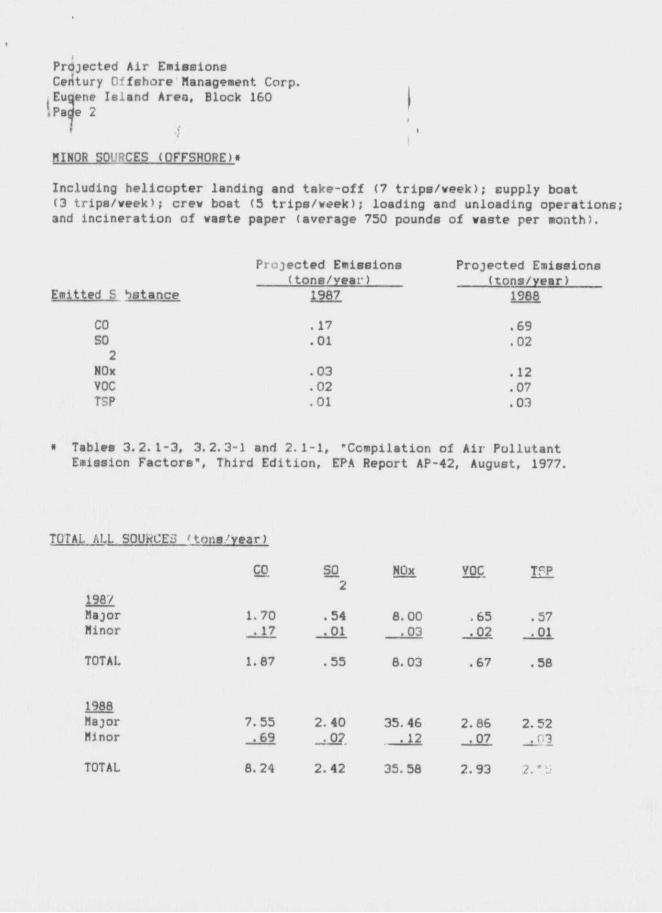
Projected A i r Emieeione Century C f shore Management Corp. Euqene Is land Area, Block 160
I Page 2
HI NOR SO1 :?C£S (OFFSHORE ) •
Including h e l i c o p t e r landing and t a k e - o f f (7 t r i p s / w e e k ) ; supply boat (3 t r ips /week ' ; crew boat (5 t r i p s / w e e k ) ; loading and unloading operat ions; and i n c i n e r a t i o n of waste paper (average 750 pounds of waste per month).
Projected Emissions Projected Emissions ( tons /year) ( tons/year)
Emitted S bstance 1987 198e
CO . 17 .69 SO .01 .02 2
NOx .03 .12 VOC .02 .07 TSP . 01 .03
• Tables 3 .2 .1-3 , 3.2.3-1 and 2 . 1 - 1 , "Ccmpilation of A i r Po l lu tan t Emission Factors" , Third E d i t i o n , EPA Report AP-42, August, 1977.
TOTAL ALL SOUKCEii ' tons year)
CO so NOx TTP 2
196/ Major 1. 70 . 54 8.00 .65 .57 Minor . 17 . 01 .03 .02 .01
TOTAL 1.87 .55 8.03 .67 .58
1986 Major 7. 55 2. 40 35.46 2.86 2. 52 Minor . 69 _.o? .12 .07 _,03
TOTAL 8. 24 2. 42 35. 58 2. 93 2."J

Projected Air Emissions Century Offshore Management Corp. Eugene Inland Art I , Block 160 Page 3 I
I ONSHORH SOURCES These should be about the same as minor sources unless nev f a c i l i t i e s are installed ?t the onshore base. No additional f a c i l i t i e s are required or planned at thia time.
BUflMM EXEMPTION DETERMINATION
2/3 2/3 co: CO: E * 3400 « 3400(65) * 54,965 tons/year For NOx, VOC, TSP & SO : E = 33.3D « 33.3(65) • 2165 tons/year
2
AS per DCI/HHS regulations, t h i r f a c i l i t y i s exempt from further a i r j a l i t y reviev as i t has been determined that i t s operations v i l l not
have a aignlficant adverse environmental impact on air quality.


![SUPPORTING INFORMATION · 2011-12-08 · 1 SUPPORTING INFORMATION Metal-free synthesis of nitrile based partially reduced thia- and oxa-thia[5]helicenes: Conformation and dynamics](https://img.pdfslide.us/doc/110x75/5e7189d55c8ef147535b93ae/supporting-2011-12-08-1-supporting-information-metal-free-synthesis-of-nitrile.jpg)


![Synthetic Routes towards 2-thia-7,8-diaza-cyclopenta[l ...277519/FULLTEXT01.pdf · 1-thia-7,8-diaza-cyclopenta[l]phenanthrene for Molecular Electronics Applications ... Kemin som](https://img.pdfslide.us/doc/110x75/5d1b94de88c993dc468d14cb/synthetic-routes-towards-2-thia-78-diaza-cyclopental-277519fulltext01pdf.jpg)