Embed Size (px)
Citation preview
August 2013
I-95 Integrated Corridor Management, Broward County
Concept of Operations
1 | P a g e
DOCUMENT CONTROL PANEL File Name: I-95 Integrated Corridor Management System, Broward County
Concept of Operations
File Location: 11555 Heron Bay Boulevard, Suite 200, Coral Springs, FL 33076
Document Tracking Number: 1
Deliverable Number: 1
Version Number: 1
Revision Number: Name Initials Date
Created By: Bob Edelstein BE 8/1/13
Reviewed By:
Modified By:
Completed By:
I-95 Integrated Corridor Management, Broward County
Concept of Operations
2 | P a g e
Table of Contents
1. Scope and Summary 1.1. Introduction 1.2. ICM Corridor Boundaries and Travel Characteristics 1.3. Corridor Stakeholders and Users 1.4. Need for Integrated Corridor Management (ICM) 1.5. ICM Vision, Goals and Objectives 1.6. ICM Concept Operational Description 1.7. Required Assets and ICM Implementation Issues 1.8. I-95 ICM Concept Institutional Framework 1.9. Summary 2. References 3. System Overview and Operational Description 3.1. Corridor Boundaries and Networks 3.1.1. Corridor Description and Boundaries 3.1.2. Corridor Networks 3.1.3. Freeway Network 3.1.4 Toll Road Network 3.1.5. Express Lanes Network 3.1.6 Rail Transit Network 3.1.7. Bus Transit Network 3.1.8. Arterial Network 3.1.9. Bicycle and Pedestrian Network 3.2. Corridor Stakeholders 3.2.1. Broward County Metropolitan Planning Organization (MPO) 3.2.2. Florida Department of Transportation (FDOT) District 4 3.2.3. Broward County Traffic Engineering Division (BCTED) 3.2.4. Broward County Transit (BCT) 3.2.5 Florida Highway Patrol (FHP) 3.2.6. South Florida Regional Transportation Authority (SFRTA) 3.2.7. South Florida Commuter Services 3.3. Operational Conditions of the Corridor and Network Assets 3.3.1. Network Conditions 3.3.2. Traffic Generators and Events 3.4. Corridor Management Tactics 3.5. ITS Assets 3.5.1. Freeway Management System 3.5.2. BCTED ITS Assets 3.5.3. BCT ITS Assets 3.5.4. SFRTA ITS Assets 3.6. Proposed Near-Term Network Improvements 3.7. Current Network - Based Institutional Characteristics 3.7.1. Institutional Agreements
I-95 Integrated Corridor Management, Broward County
Concept of Operations
3 | P a g e
3.7.2. Stakeholder Institutional Challenges 3.8. Regional ITS Architecture Review 3.9. Individual Network and Corridor Challenges and Needs 3.9.1. Network Challenges 3.9.2. Network Needs 3.10. Potential for ICM in the Corridor 3.11. Corridor Vision 4. ICM System Operational Concept 4.1. Corridor Goals and Objectives 4.2. User Needs 4.2.1 Use Cases 4.2.2. Use Case Development 4.3. Application of ICM Approaches and Strategies 4.4. ICM Concept Asset Requirements and Needs 4.5. Corridor Concept Operational Description 4.6. Alignment with Regional ITS Architecture 4.7. Implementation Issues 4.8. Corridor ICM Concept Institutional Framework 4.9. Performance Measures 4.10. ICM User Needs and Functionality 5. ICM Operational Scenarios 5.1. Future ICM Operational Conditions 5.2. Scenarios 5.3. Decision Support System 5.3.1. High-Level Functionality and Capability 5.4. Daily Operations 5.5. Traveler Information 5.6. Incident Scenario 5.6.1. Major Traffic Incident – Arterials 5.6.2. Major Traffic Incident – Freeway 5.6.3. Major Transit Incident 5.7. Weather Event Scenario Figures 1-1 FHWA Systems Engineering “V” Diagram 3-1 Southeast Florida Regional Express Lanes Network 3-2 TSM&O Program in Broward County 3-3 TSM&O Network in Broward County 4-1 I-95 ICM Asset Requirements and Needs
I-95 Integrated Corridor Management, Broward County
Concept of Operations
4 | P a g e
List of Acronyms
ATIS Advanced Traveler Information System
ATM Active Traffic Management
ATMS Advanced Traffic Management System
AVL Automated Vehicle Location
BCT Broward County Transit
BCTED Broward County Traffic Engineering Division BRT Bus Rapid Transit
C2C Center to Center
CAD Computer Aided Dispatch
CCTV Closed Circuit Television
ConOps Concept of Operations
DMS Dynamic Message Sign
DSS Decision Support System ETA Estimated Time of Arrival
FDOT Florida Department of Transportation
FHP Florida Highway Patrol
FHWA Federal Highway Administration
FLATIS Florida Advanced Traveler Information System
FTA Federal Transit Administration
FTE Florida Turnpike Enterprise HOV High Occupancy Vehicle
ICM Integrated Corridor Management
ITS Intelligent Transportation System
JPO Joint Program Office
MDT Miami Dade Transit
MPO Metropolitan Planning Organization
PBCTED Palm Beach County Traffic Engineering Division PDA Personal Digital Assistant
RCTO Regional Concept of Transportation Operations
SEFRTOC South East Florida Regional TMC Operations Committee
SFRTA South Florida Regional Transportation Authority
SIRV Severe Incident Response Vehicle
TDM Transportation Demand Management
TIM Traffic Incident Management TMC Transportation Management Center
TSM&O Transportation Systems Management & Operations
TSP Transit Signal Priority
USDOT United States Department of Transportation
VPD Vehicles Per Day
I-95 Integrated Corridor Management, Broward County
Concept of Operations
5 | P a g e
I-95 Integrated Corridor Management System Broward County, Florida Concept of Operations
1. Scope and Summary 1.1. Introduction
A two-day workshop was conducted during April 29-30, 2013 to explore how the regional transportation system within Southeast Florida may be enhanced through Integrated Corridor Management. Integrated Corridor Management (ICM) consists of the operational coordination of multiple transportation networks and cross-network connections comprising a corridor, and the coordination of institutions responsible for corridor mobility. The goal of ICM is to improve mobility, safety, and other transportation objectives for travelers and goods. ICM may encompass several activities, including:
Cooperative and integrated policy among stakeholders. Concept of operations for corridor management. Communications among network operators and stakeholders. Improving the efficiency of cross-network junctions and interfaces. Mobility opportunities, including shifts to alternate routes and modes. Real-time traffic and transit monitoring. Real-time information distribution (including alternative networks). Congestion management (recurring and non-recurring). Incident management. Travel demand management. Public awareness programs. Transportation pricing and payment.
ICM may result in the deployment of an actual transportation management system connecting the individual network-based transportation management systems (complete with central hardware and servers, data base, decision support software, joint sharing of command and control activities, etc.); or may just be a set of operational procedures agreed to by the network owners with appropriate linkages between their respective systems. Regardless of the type of “system” deployed, the process steps and associated activities identified herein are directly applicable. In the context of ICM, integration is a bridging function between the various networks that make up a corridor, and involves processes and activities that facilitate a more seamless operation. In order to implement ICM, the transportation networks within a corridor (and their respective ITS systems) need to be “integrated” in several different ways, specifically:
Operational integration may be viewed as the implementation of multi-agency transportation management strategies, often in real-time, that promote information sharing and cross-network coordination and operations among the various transportation networks in the corridor, and facilitate management of the total capacity and demand of the corridor.
Institutional integration involves the coordination and collaboration between various agencies and jurisdictions (network owners) in support of ICM, including the distribution of specific
I-95 Integrated Corridor Management, Broward County
Concept of Operations
6 | P a g e
operational responsibilities and the sharing of control functions in a manner that transcends institutional boundaries.
Technical integration provides the means (e.g., communication links between agencies, system
interfaces, and the associated standards) by which information and system operations and control functions can be effectively shared and distributed among networks and their respective transportation management systems, and by which the impacts of operational decisions can be immediately viewed and evaluated by the affected agencies.
The various issues associated with operational, institutional, and technical integration are closely related and interdependent; for example, operational integration can be more effective when technical integration has been implemented; successful technical and operational integration typically requires institutional integration (and the associated managerial support and funding) as a prerequisite; while ongoing operations and maintenance (considered an operational integration issue) is equally important to the long term technical success of an ICM program. This Concept of Operations (ConOps) for the I-95 ICM focuses on the 25-mile corridor within Broward County, recognizing the potential to expanding it throughout the Tri-County region (i.e., Miami-Dade, Broward and Palm Beach Counties). The corridor serves as a primary commuter route for travel within the Tri-County region as well as for freight movement, intra-state and inter-state trips. The I-95 corridor, including Tri-Rail, Broward County Transit (BCT) buses, express lanes, and an advanced traffic management signal system, has the potential to support multi-modal deployment of evolving technologies for data collection, demand management, and pricing strategies. The region can benefit by providing additional value from comprehensive approaches to transportation management. The statewide 511 Florida Advanced Traveler Information System (FLATIS) provides corridor users with real-time information and efficient travel alternatives. This document provides an overview of the I-95 ICM concept within Broward County, describes current operations within the corridor, how they will function in the near term once the ICM concept is operational, and identifies current and future responsibilities of regional stakeholders. By highlighting the flexible and innovative approaches to management along this corridor, the user will understand how improvements currently underway along the corridor serve as a foundation for even further integration in the future. This document was developed based on the ConOps prepared for the two ICM projects currently in the pilot testing phase (i.e., Dallas and San Diego) customized to reflect the transportation systems within Southeast Florida. As the stakeholders within the Southeast Florida region continue to conduct ICM workshops in the future, this ConOps will be refined to reflect the operating philosophies, strategies and decisions to subsequently develop functional requirements for the I-95 ICM. Successful implementation of the I-95 ICM concept requires a proactive, strategic, and collaborative approach to public and private-sector stakeholder partnerships. A Virtual Transportation Management Center (Virtual TMC) outlined in this document would allow for the coordination among multiple agencies on multiple levels for data collection and processing, data sharing, and decision support based on workflow and on an expansion of available information. By providing a user-oriented view of the potential for integrated management along the I-95 corridor, the ConOps focuses on the corridor’s needs and problems, goals and objectives, proposed operational approaches, and strategies for attaining these goals, the institutional framework in which the ICM would
I-95 Integrated Corridor Management, Broward County
Concept of Operations
7 | P a g e
operate, and the associated operational, technical, and institutional issues that need to be addressed in the future. Regional partnerships can fully capitalize on existing technologies to design and implement deployment and technology transfer initiatives to improve corridor mobility and productivity along the corridor.
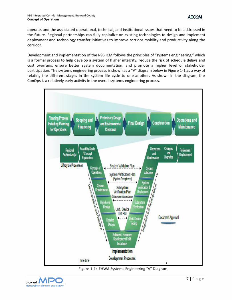
Development and implementation of the I-95 ICM follows the principles of “systems engineering,” which is a formal process to help develop a system of higher integrity, reduce the risk of schedule delays and cost overruns, ensure better system documentation, and promote a higher level of stakeholder participation. The systems engineering process is shown as a “V” diagram below in Figure 1-1 as a way of relating the different stages in the system life cycle to one another. As shown in the diagram, the ConOps is a relatively early activity in the overall systems engineering process.
Figure 1-1: FHWA Systems Engineering “V” Diagram
I-95 Integrated Corridor Management, Broward County
Concept of Operations
8 | P a g e
The I-95 ICM ConOps is essentially a user-oriented perspective of integrated corridor management; therefore, corridor stakeholders play the primary role in its development. The ConOps answers the following set of questions:
Why: Justification for ICM within the I-95 corridor, identifying what the corridor currently lacks, and what the system would provide
What: Currently known elements and high-level capabilities of the system Where: Geographical and physical extents of the system Who: Stakeholders involved with the system and their respective responsibilities When: Time sequence of activities that would be performed How: Resources needed to design, build, operate, and maintain the system
The ConOps does not detail the technology or requirements of the I-95 ICM, but it does address the operational scenarios and objectives, information needs, and overall functionality. The ConOps also addresses the institutional environment in which integrated corridor management must be deployed, operated, and maintained. 1.2. ICM Corridor Boundaries and Travel Characteristics
I-95 is a 90-mile corridor within Southeast Florida covering Miami-Dade, Broward and Palm Beach Counties. While the corridor is regional, this ConOps focuses on Broward County in developing operational strategies as a component of the Transportation Systems Management & Operations (TSM&O) program included in the Broward MPO 2040 Long Range Transportation Plan Update. The I-95 corridor includes express lanes of which 7.2 miles are currently in operation within Miami-Dade County (SR 836 to Golden Glades Interchange); 14 miles are under construction within Miami-Dade and Broward County (Golden Glades Interchange to Broward Boulevard); and an additional 30 miles are under development within Broward and Palm Beach Counties (Broward Boulevard to Linton Boulevard). The 95 Express is a critical component of the regional express lanes network that includes I-595 (under construction) and I-75 (under development) within Broward County and SR 826 (under development) and the HEFT (under construction) in Miami-Dade County. The I-95 corridor is a critical component of the regional transportation systems within Southeast Florida. It is one of three primary north-south transportation corridors within Broward County (i.e., I-95, Florida Turnpike, I-75 / Sawgrass Expressway), serving commuter, freight and interregional travel. The I-95 corridor is situated within a major interregional goods movement corridor connecting the Port of Miami, Port Everglades and Port of Palm Beach. It also plays a key role in providing access to the region’s three international airports. The 95 Express operates as priced managed lanes that drivers can choose to use with tolls varying with the level of congestion. The goal is to keep traffic in the express lanes moving at a minimum speed of 45 mph while maximizing person throughput of the entire facility. Registered vanpools, 3+ carpools and hybrid vehicles, plus transit school and over‐the‐road buses may use the express lanes toll‐free. Motorcycles may also use the facility toll‐free without registering. Trucks of three or more axles are not allowed to use the express lanes.
I-95 Integrated Corridor Management, Broward County
Concept of Operations
9 | P a g e
I-95 is in the jurisdiction of FDOT Districts 4 and 6. Partnerships exist with the South Florida Regional Transit Authority (SFRTA), which operates Tri-Rail within the corridor as well as bus transit agencies in Miami-Dade, Broward and Palm Beach Counties. The corridor includes the following networks:
Freeway Network that includes I-95, I-75 and I-595. I-95 is operated and maintained by FDOT Districts 4 and 6 with agreements with the Florida Highway Patrol (FHP) to manage incidents (i.e., Open Roads Policy) and Florida Turnpike Enterprise for toll collection systems as part of the 95 Express. I-95 includes four to five lanes in each direction, and will include two express lanes in each direction when completed.
Toll Road Network that includes the Florida Turnpike within all three counties; the Sawgrass
Expressway in Broward County; and five toll roads within Miami-Dade County (i.e., SR 836, SR 112, SR 874, SR 878, SR 924). The Florida Turnpike Enterprise operates and maintains the Florida Turnpike and Sawgrass Expressway while the Miami-Dade Expressway Authority operates and maintains the five toll roads within Miami-Dade County.
Arterial Network that encompasses Miami-Dade, Broward and Palm Beach Counties. Each county’s, and certain municipality’s (i.e., Boca Raton, West Palm Beach), public works/transportation department operates the arterial traffic management signal systems.
Transit Network that includes Tri-Rail commuter rail services between the three counties and bus operations provided by Miami-Dade Transit (MDT), Broward County Transit (BCT) and Palm Tran. Bus Rapid Transit operates along the 95 Express.
1.3. Corridor Stakeholders and Users I-95 corridor stakeholders will play an important role in the integrated corridor management program, including the following:
Broward County Metropolitan Planning Organization (MPO) Miami-Dade Metropolitan Planning Organization (MPO) Palm Beach Metropolitan Planning Organization (MPO) Florida Department of Transportation (FDOT) District 4 Florida Department of Transportation (FDOT) District 6 Florida Turnpike Enterprise Miami-Dade Expressway Authority Florida Highway Patrol Broward County Traffic Engineering Division (BCTED) Miami-Dade Public Works Department Palm Beach County Traffic Engineering Division (PBCTED) City of Boca Raton Traffic Division City of West Palm Beach Traffic Division Broward County Transit (BCT) Miami-Dade Transit (MDT) Palm Beach County Transit (Palm Tran) South Florida Regional Transit Authority (SFRTA) South Florida Commuter Services
I-95 Integrated Corridor Management, Broward County
Concept of Operations
10 | P a g e
An I-95 ICM Committee should be formed, inclusive of representatives of the above agencies, to continue the development, implementation, and operation of the ICM as it proceeds through the systems engineering process. 1.4. Need for Integrated Corridor Management (ICM)
The ICM concept has the potential to optimize “people” throughput capacity within the I -95 corridor. This concept may be realized through the coordinated operations of the individual transportation operations within the corridor. Each of the traffic networks within the corridor are experiencing congestion to some extent during peak hours. “Integrated Corridor Management” focuses on the operational, institutional, and technical coordination of multiple transportation networks and cross-network connections comprising a corridor. Strategies for the I-95 ICM would be developed that would assist in operating the corridor in a more efficient and safe manner and have a positive impact to the overall economy of the region. The first major area deals with information sharing both with the public and among agencies. Sharing of information could be used for better informing the public of the operations of the corridor and the availability and impact of different modes. The corridor could provide comparative travel times across modes, so that travelers can make informed decisions about trips they are about to make. This may include the ability to collect and distribute arterial travel time data via various media including 3rd party traveler information providers, websites, and subscription services for phones and PDAs. One of the areas that is needed is coordinated response plans and a decision support tool to assist with the on-going operations of the corridor. This decision support tool would be integrated with the various agencies, and provide multiagency responses scenarios that have been modeled, agreed to, or meet certain criteria. The agencies would identify hot spots where re-occurring incidents and special events occur, and develop responses that are coordinated and agreed upon by the agencies. One of the deficiencies that need to be addressed involves the exchange and sharing of real-time data. With real-time data and video among the networks, each network could monitor the conditions of adjacent networks to anticipate when travelers may shift to their network and take appropriate actions. Moreover, real-time condition information would provide the foundation for corridor-wide traveler information. A Regional Data and Video Communication System may be considered that would serve as the central distribution point for sharing video among corridor agencies. Currently several agencies share some of their video images. Another element of ICM that is needed is outreach and marketing to the public and major employers within the corridor. Currently, many travelers utilize FLATIS, the regional website and 3rd party traveler information products to find out about current conditions. One of the strategies may be outreach to major employers and freight companies to provide customized traveler information to them. Another potential element of ICM involves enhanced mobility opportunities, including shifts to alternate routes and modes. Currently, any shifts that do occur are based on traveler knowledge and past experience. Using integrated real-time information, the various networks working as a corridor could influence traveler network shifts; especially promoting, when appropriate, shifts to the rail network with its unused capacity. Parking notification could be used to direct travelers to available parking; or in some situations temporary parking may be instituted to accommodate the new demand.
I-95 Integrated Corridor Management, Broward County
Concept of Operations
11 | P a g e
Dynamic Message Signs (DMS) deployed among the networks could be operationally integrated and messages could be used to provide travelers condition information on all corridor networks so that each traveler can take appropriate action if one or more of the corridor’s network’s performance is compromised. More can be done with corridor trip travel times to influence traveler shifts, or staggering of the start of travel. For special events, DMSs could be used to direct event attendees to specific event corridor transportation services. There is potential to enhance current and near-term operations by implementing selected ICM and cross-network strategies. All of these enhancements would not be possible from an independent network operational perspective. The potential strategies identified above indicate that further investigation and design concerning ICM is warranted.
1.5. ICM Vision, Goals and Objectives
The I-95 ICM is a collaborative effort between the regional stakeholders with the vision defined as follows: “Operate the I-95 Corridor in a true multimodal, integrated, efficient, and safe fashion where the focus is on the transportation customer.” Using the Vision Statement as a starting point, specific goals for the ICM should be developed along with objectives and strategies for each of the goals. These goals and objectives may include the following:
Increase Corridor Throughput – While the agencies within the corridor have focused on increasing throughput of their individual networks, the ICM would build on these network initiatives, managing delays on a corridor basis, utilizing any spare capacity within the corridor, and coordinating the junctions and interfaces between networks, in order to optimize the overall throughput of the corridor. Specifically, this may include the following objectives:
- Increase transit ridership, with minimal increase in transit operating costs. - Improve the efficiency of freight movement through the corridor - Maximize the efficient use of spare corridor capacity, such that delays on other saturated
networks may be reduced. - Facilitate intermodal transfers and route and mode shifts - Improve pre-planning (e.g., developing response plans) for incidents, events, and
emergencies that have corridor and regional implications.
Improve Travel Time Reliability – Similarly, while the agencies within the corridor have focused on improving travel time reliability of their individual networks, the ICM would build on these network initiatives, managing delays on a corridor basis, utilizing any spare capacity within the corridor, and coordinating the junctions and interfaces between networks, thereby providing a multi-modal transportation system that adequately meets customer expectations for travel time predictability. Specifically, this may include the following objectives:
- Reduce overall trip and person travel time through the corridor. - Improve travel predictability. - Maximize the efficient use of spare corridor capacity, such that delays on other saturated
networks may be reduced. - Improve commercial vehicle operations through and around the corridor.
I-95 Integrated Corridor Management, Broward County
Concept of Operations
12 | P a g e
Improved Incident Management – Provide a corridor-wide and integrated approach to the management of incidents, events, and emergencies that occur within the corridor or that otherwise impact the operation of the corridor, including planning, detection and verification, response and information sharing, such that the corridor returns back to “normal.” The Traffic Incident Management (TIM) Teams in each of the three counties have been meeting on a regular basis since the 1980s as part of regional as well as countywide meetings. Furthermore, the Southeast Florida Regional Transportation Management Center Operations Center Committee (SEFRTOC) has also been meeting for several years on a regular basis to address operational issues among the regional Transportation Management Centers (TMCs). Specifically, improved incident management strategies may include the following:
- Provide/expand means for communicating consistent and accurate information regarding
incidents and events between corridor networks and public safety agencies. - Provide an integrated and coordinated response during major incidents and emergencies,
including joint-use and sharing of response assets and resources among stakeholders, and development of a common policies and processes.
- Continue comprehensive and on-going training program – involving all corridor networks and public safety entities – for corridor event and incident management.
Enable Intermodal Travel Decisions - Travelers should be provided with a holistic view of the
corridor and its operation through the delivery of timely, accurate and reliable multimodal information, which then allows travelers to make informed choices regarding departure time, mode and route of travel. In some instances, the information would recommend travelers to utilize a specific mode or network. Advertising and marketing to travelers over time would allow a greater understanding of the modes available to them. Specifically, this may include the following objectives:
- Facilitate freight movement and intermodal transfers and route and mode shifts - Increase transit ridership - Expand existing FLATIS systems to include mode shifts as part of pre-planning - Expand coverage and availability of traveler information devices - Obtain accurate real-time on the current status of the corridor network and cross network
connections 1.6. ICM Concept Operational Description
The I-95 ICM would provide efficient and reliable travel throughout the corridor and the constituent networks, resulting in improved and consistent trip travel times. Using cross-network strategies, the I-95 ICM would capitalize on integrated network operations to manage the total capacity and demand of the system in relation to the changing corridor conditions. The I-95 ICM would provide a system that would generate comparative corridor data in real-time on freeways, express lanes, arterials, toll roads and transit facilities. The system would forecast corridor operations one hour into the future, analyze potential corridor operating strategies and their benefits, and communicate recommended response plans back to the corridor operating agencies. Each operating agency would continue to be responsible for implementing their part of a response plan; however, the actions and corridor impacts can be monitored from the regional traveler information web site.
I-95 Integrated Corridor Management, Broward County
Concept of Operations
13 | P a g e
Daily operation of the corridor would be an expansion of the existing relationships and operations of the agencies within the region with additional coordination, communication, and responses to congestion and incidents within the corridor; however, it would now be applied on a permanent basis for day-to-day operations. All operations among corridor networks and agencies would be coordinated through a corridor decision support system interconnected with the regional center-to-center communication network. Corridor response plans would be developed and updated for various scenarios that can be expected to occur within the I-95 Corridor. Communications, systems, and system networks would be integrated to support the corridor and decision support system. Voice, data, video, information, and control would be provided to all agencies based on the adopted protocols and standards for the sharing of information and the distribution of responsibilities. Traveler information (on websites, DMS, and through the media and 3rd party traveler information providers) would be corridor based, providing information on corridor trip alternatives complete with current and predicted conditions. Travelers would access or be given real-time corridor information so they can plan or alter their trips in response to current or predicted corridor conditions. Each traveler would be able to make route and modal shifts between networks easily due to integrated corridor information, integrated fare/parking payment system, and coordinated operations between networks. Using one network or another would be dependent on the preferences of the traveler, and not the nuances of each network. Travelers would be able to educate themselves about the corridor so they can identify their optimal travel alternatives and obtain the necessary assets (e.g., smart card, available parking) to facilitate their use of corridor alternatives when conditions warrant. 1.7 Required Assets and ICM Implementation Issues The assets and processes that are needed for a more integrated corridor would be prioritized and accounted for when the high-level and detailed level requirements and designs are developed in the future as a part of the systems engineering process. A key component of this prioritization is the corridor models that are in development. These models would be utilized to review and analyze the proposed strategies, to determine which strategies are the most efficient for the corridor and are technologically feasible with the existing systems. The ICM concept represents a paradigm shift for management and operations within the corridor - from the current partial coordinated operations between corridor networks and agencies, to a fully integrated and proactive operational approach that focuses on a corridor perspective rather than a collection of individual (and relatively independent) networks. To make this happen, several implementation and integration issues need to be resolved. Several of these implementation issues would involve choices that cannot be fully addressed and subsequently resolved until later stages of the systems engineering process (e.g., design, procurement, and implementation). 1.8 ` I-95 ICM Concept Institutional Framework
In developing the institutional framework, many configurations and institutional arrangements need to be considered to continue and improve upon a decentralized operational model with a centralized
I-95 Integrated Corridor Management, Broward County
Concept of Operations
14 | P a g e
decision making body for cooperation and oversight. The institutional framework would utilize existing institutional cooperation agreements, and expand on them specifically for the corridor. 1.9 Summary
The I-95 Steering Committee needs to be committed to the concepts of ICM and agree to continue the pursuit of working in a more coordinated and efficient manner for the I-95 Corridor. The key areas of commitment include focusing on the continued expansion and integration of information sharing between the agencies and the traveling public. The agencies in the corridor would be making improvements to the corridor infrastructure that would assist in improving the integration and infrastructure for the corridor.
I-95 Integrated Corridor Management, Broward County
Concept of Operations
15 | P a g e
2. References The following documents were used in developing the ConOps for the I-95 ICM project:
USDOT, “Integrated Corridor Management, Phase 1 – Concept Development and Foundational Research, Task 2.5 – ICM Implementation Guidance”, ITS Joint Program Office, FHWA-JPO 06-042, EDL Number 14284, April 12, 2006.
San Diego Pioneer Site Team, “Concept of Operations for the I-15 Corridor in San Diego, California”, FHWA-JPO 08-009, EDL Number 14395, March 31, 2008.
DART in association with City of Dallas, Town of Highland Park, North Central Texas Council of
Governments, NTTA, City of Plano, City of Richardson, TXDOT, City of University Park, “Concept of Operations for the US-75 Integrated Corridor in Dallas, Texas”, FHWA-JPO 08-004, EDL Number 14390, April 30, 2008.
USDOT, “Southeast Florida Explores Integrated Corridor Management (ICM) to Take Two
Decades of TSM&O Vision and Investments to the Next Level”, TSM&O and ICM Workshop, April 29-30, 2013.
I-95 Integrated Corridor Management, Broward County
Concept of Operations
16 | P a g e
3. System Overview and Operational Description 3.1. Corridor Boundaries and Networks The corridor boundaries considered the Tri-County region (i.e., Miami-Dade, Broward and Palm Beach Counties); however, the focus of this study is Broward County as this document serves as a component to the Broward MPO 2040 Long Range Transportation Plan Update. In addition to a description of the corridor boundaries, travel networks included within the corridor are also described in this Section. The networks include: arterial streets, freeways, express lanes, toll roads, bus and rail transit, vanpool, and pedestrian/bicycle facilities. 3.1.1. Corridor Description and Boundaries This ConOps is defined for the I-95 Corridor. I-95 is a major north-south interstate highway traversing the entire United States, inclusive of all of Broward County (25 miles). The corridor contains freeways (i.e., I-95, I-75, I-595); express lanes (i.e., 95 Express); toll roads (i.e., Florida Turnpike, Sawgrass Expressway); commuter rail (i.e., Tri-Rail); transit bus service (i.e., Broward County Transit); park & ride lots, arterial streets, bike trails, and an ITS infrastructure. Within the next few years, the express lane network will be expanded along I-595, I-75 and Florida’s Turnpike within Broward County. In addition, a Transportation Systems Management & Operations (TSM&O) network along key arterials is being implemented. I-95 was Broward County’s first major freeway – completed during the 1960s. This section of freeway was reconstructed to include High Occupancy Vehicle (HOV) lanes during the 1990s with a minimum of three general purpose lanes and one HOV lane in each direction. I-95 carries between 200,000 and 300,000 vehicles per day (vpd). The I-95 ICM Corridor also contains the first commuter rail line constructed within Florida, part of the 73-mile Tri-Rail system, opened in 1986. This facility operates at-grade along the CSXT tracks which parallel I-95 on the west side. The I-95 ICM Corridor serves commuting, regional and interregional trips via the freeway, bus routes, rail line, and arterial streets as well as freight traffic. Additionally, the Corridor serves as a major evacuation route. There are significant employment destinations within the corridor (e.g., Fort Lauderdale Central Business District), major airports and seaports; and major shopping centers. There is one major freeway interchange along I-95 within Broward County – I-595 which is located within central Broward County. In addition, the I-95 interchange at SW 10th Street provides access to the Sawgrass Expressway within northern Broward County. Primary state arterials provide connections between I-95 and the Florida Turnpike, Sawgrass Expressway and I-75. 3.1.2 Corridor Networks This section describes the networks contained within the I-95 ICM Corridor. A network is defined for the purposes of this ConOps as a system of transportation infrastructure that is independent of agency or jurisdictional boundary. A description of each network is provided in more detail below.
I-95 Integrated Corridor Management, Broward County
Concept of Operations
17 | P a g e
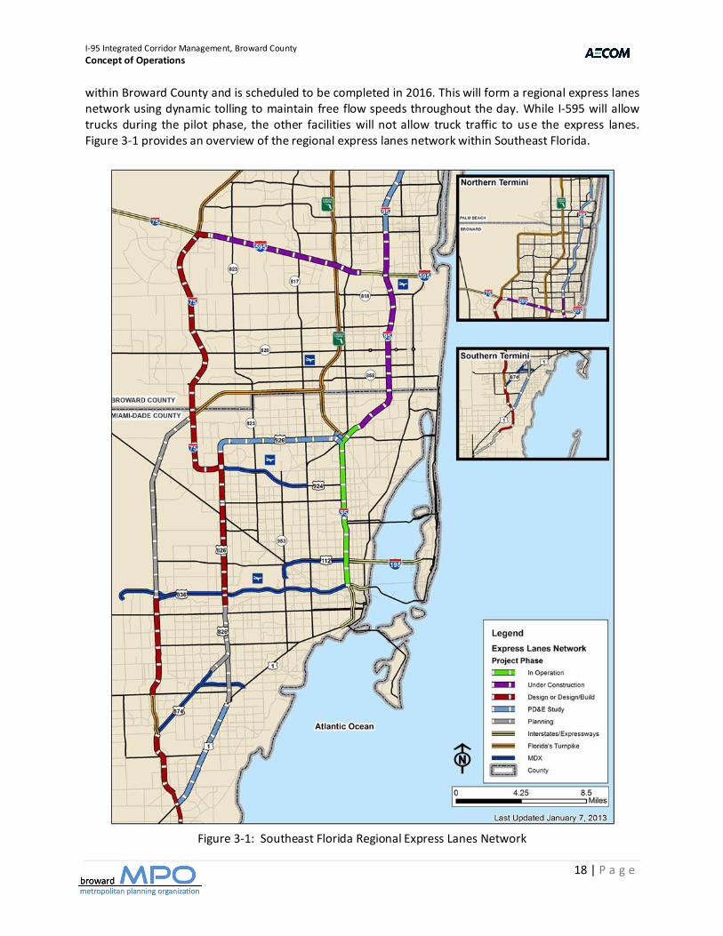
3.1.3. Freeway Network I-95 is operated and maintained by FDOT District 4 within Broward County. If an incident causes the closure of the roadway, or individual lanes, traffic can be routed to parallel arterials, toll roads and interstate highways. Express lanes are currently being constructed as an extension of the 95 Express which has been operational in Miami-Dade County since 2008. The current construction of the expansion of the 95 Express will terminate in central Broward County (i.e., Broward Boulevard) with a planned future extension of the express lanes into Palm Beach County during the next few years. I-595 is currently being operated and maintained by a concessionaire as part of a 35-year public-private partnership agreement with FDOT. This east-west 15-mile facility includes three general purpose lanes in each direction, along with frontage roads between I-75 and the Florida Turnpike. I-595 is currently being reconstructed to provide a reversible express lane system within the median between I-75 on the west and the Florida Turnpike on the east as well as braided interchanges and a continuous frontage road system. I-595 carries between 160,000 and 210,000 vpd. I-75 is a north-south interstate highway between SR 826 in Miami-Dade County and the I-595 interchange in Broward County. I-75 also has an east-west component which traverses the Everglades (i.e., Alligator Alley) to the west coast of Florida, then traverses the west coast in the north-south direction. The Broward County portion of I-75 was built during the 1980s as a six-lane divided interstate highway with a wide median. During the next few years, the north-south section within Broward and Miami-Dade Counties will be widened to add two Express Lanes in each direction plus other improvements. I-75 carries between 140,000 and 150,000 vpd. 3.1.4 Toll Road Network The Florida Turnpike is operated and maintained by the Florida Turnpike Enterprise. The Turnpike includes eight interchanges within Broward County located at the following locations: Hollywood Boulevard, Griffin Road, I-595, Sunrise Boulevard, Commercial Boulevard, Atlantic Boulevard, Sample Road, and SW 10th Street. The Sawgrass Expressway is operated and maintained by the Florida Turnpike Enterprise. It was built during the 1980s as a four-lane divided toll road, then upgraded to a six-lane facility. The toll road includes two mainline toll plazas at the south and north ends as well as ramp toll plazas. Both the Florida Turnpike and Sawgrass Expressway utilize high-speed electronic toll collection-only (ETC) lanes, and toll booth lanes that accept either electronic or cash payment. 3.1.5. Express Lanes Network Southeast Florida is in various stages of developing an express lanes network. Within Broward County, express lanes are being, or will be, constructed along I-95, I-595 and I-75 (north-south segment). The 95 Express, between SR 836 and Golden Glades Interchange within Miami-Dade County (7.2 miles), has been operational since 2008. The 14-mile extension, between the Golden Glades Interchange and Broward Boulevard (14 miles), will have three access points in each direction within Broward County and is scheduled to be completed in 2014. In addition, the I-595 reversible express lanes are scheduled to be completed in 2014 and have access points only at the western terminus (i.e., I-75) and at the Florida Turnpike interchange. Construction of the I-75 express lanes will include four intermediate access points
I-95 Integrated Corridor Management, Broward County
Concept of Operations
18 | P a g e
within Broward County and is scheduled to be completed in 2016. This will form a regional express lanes network using dynamic tolling to maintain free flow speeds throughout the day. While I-595 will allow trucks during the pilot phase, the other facilities will not allow truck traffic to use the express lanes. Figure 3-1 provides an overview of the regional express lanes network within Southeast Florida.
Figure 3-1: Southeast Florida Regional Express Lanes Network
I-95 Integrated Corridor Management, Broward County
Concept of Operations
19 | P a g e
3.1.6 Rail Transit Network Tri-Rail is owned and operated by the South Florida Regional Transit Authority (SFRTA). Within Broward County, stations are located at the following locations: Hollywood Boulevard, Sheridan Street, Griffin Road (Fort Lauderdale / Hollywood International Airport), Broward Boulevard, Cypress Creek Road, Sample Road and Hillsboro Boulevard. In addition, the WAVE street car system will be built within the Fort Lauderdale Central Business District during the next few years. Also, a high-speed rail system and commuter rail line is being planned to operate along the FEC rail corridor. 3.1.7. Bus Transit Network Each of the three counties operates a bus network within Southeast Florida. Broward County Transit (BCT) operates 291 fixed route buses per day, including articulated express buses along I-95 and I-595 in linking Broward County and Miami. The BCT bus network consists of various types of services. There is local bus service serving specific areas characterized by frequent stops. In addition, express routes and cross-town routes serve longer distance trips. Express routes have less frequent stops and generally run on the primary arterials within the Corridor. There is also a Tri-Rail feeder bus service providing access between Tri-Rail stations and local destinations. 3.1.8. Arterial Network The arterial street system consists of several major north-south as well as east-west arterial streets. These primary streets are typically spaced at one-mile intervals and serve as primary travel routes and potentially as alternate routes for traffic diverted from freeways and toll roads. The key north-south arterials within the I-95 ICM Corridor include: US 1, Powerline Road and SR 7. There are also several key east-west arterials. These arterials are critical for moving traffic between the north-south routes, especially for diversion purposes. In general, the arterials are on a grid pattern. The key east-west arterials within Broward County are:
Hallandale Beach Boulevard Griffin Road Atlantic Boulevard
Pembroke Road Broward Boulevard Copans Road Hollywood Boulevard Sunrise Boulevard Sample Road
Sheridan Street Oakland Park Boulevard SW 10th Street
Stirling Road Commercial Boulevard Hillsboro Boulevard
Davie Boulevard Cypress Creek Road
3.1.9. Bicycle and Pedestrian Network At its May 2011 meeting, the Broward MPO took its first step in changing how roads are designed in Broward County. The MPO Board passed a resolution encouraging cities and implementing agencies to develop their roads as complete streets and to use the Institute of Transportation Engineers’ Guide ”Designing Walkable Urban Thoroughfares: A Context Sensitive Approach” in this effort.
Complete Streets are designed and operated to enable safe access for all users including pedestrians, bicyclists, motorists and transit riders. Complete Streets will facilitate users to cross the street, walk to
I-95 Integrated Corridor Management, Broward County
Concept of Operations
20 | P a g e
shops, and bicycle to work as well as allow buses to run on time and make it safe for people to walk to and from bus stops and train stations.
Creating complete streets will require transportation agencies to change their approach to planning, designing or redesigning their roads. They will need to consider bicyclists, pedestrians and transit users first, not last. They will need to think about the capacity not by how many vehicles move through the corridor, but instead by how many people are moving through the corridor. There is not a one size fits all solution and will have to be considered in the context of the community and the corridor.
3.2. Corridor Stakeholders There are several public agency stakeholders in the I-95 ICM Corridor within Broward County. A description of each stakeholder is included in more detail below. 3.2.1. Broward County Metropolitan Planning Organization (MPO) The Broward MPO is a transportation policy-making board responsible for transportation planning and funding allocation in Broward County. The Broward MPO works with the public, planning organizations, government agencies, elected officials, and community groups to develop transportation plans. The Broward MPO’s vision is to transform transportation in Broward County to achieve optimum mobility with emphasis on mass transit while promoting economic vitality, protecting the environment, and enhancing quality of life. The mission of the Broward MPO is to influence the expenditure of federal and state funds to provide a regional transportation system that ensures the safe and efficient mobility of people and goods, optimizes transit opportunities, and enhances our community’s environmental and economic well-being. ICM is a component of the TSM&O program that is included as part of the Broward MPO 2040 Long Range Transportation Plan Update.
3.2.2. Florida Department of Transportation (FDOT) District 4
The Florida Department of Transportation (FDOT) is an executive agency, directly reporting to the Governor. FDOT’s primary statutory responsibility is to coordinate the planning and development of a safe, viable, and balanced state transportation system serving all regions of the state, and to assure the compatibility of all components, including multimodal facilities. Florida’s transportation system includes roadway, air, rail, sea, spaceports, bus transit, and bicycle and pedestrian facilities. FDOT District 4 has jurisdiction over the following five counties: Broward, Palm Beach, Martin, St. Lucie and Indian River.
3.2.3. Broward County Traffic Engineering Division (BCTED)
The Broward County Traffic Engineering Division (BCTED) is organized into five sections: Management and Administration, Signal Systems, Signal Construction and Maintenance, Signs and Markings, Traffic Studies. This includes maintaining signs and signals on a 24/7 basis. Their mission is to “work together to provide for the safe and efficient movement of pedestrians, cyclists and vehicular traffic within the County”. The Signal Systems Section operates and maintains a countywide computer controlled traffic signal system to protect motorists and pedestrians, reduce motorist travel time and aid in the efficiency of roadways. The section is responsible for the design of new signals and the evaluation of signal timing and phasing. The Signal Maintenance Section is responsible for the maintenance of traffic signal systems, and the maintenance of roadway lighting on selected roadways.
I-95 Integrated Corridor Management, Broward County
Concept of Operations
21 | P a g e
3.2.4. Broward County Transit (BCT) Broward County Transit (BCT) provides bus service within Broward County covering 410 square miles within throughout the County with buses connecting to Palm Beach and Miami-Dade transit systems and to Tri-Rail. BCT operates 291 fixed route buses, 29 express buses, 77 community buses and 218 paratransit vehicles (contracted service). Hours of operation start as early as 4:40 a.m. and run as late as until 12:35 a.m. There are 4,521 designated bus stops and 719 bus shelters. BCT carries 125,000 passengers daily (37.9 million trips annually) and has an annual service of 13.7 million miles. BCT has partnered with municipalities in providing community bus service in Coconut Creek, Coral Springs, Dania Beach, Davie, Deerfield Beach, Fort Lauderdale, Hallandale Beach, Hillsboro Beach, Lauderdale-By-The-Sea, Lauderdale Lakes, Lauderhill, Lighthouse Point, Margate, Miramar, Pembroke Pines, Plantation, Pompano Beach and Tamarac. 3.2.5 Florida Highway Patrol The Florida Highway Patrol (FHP) is a division of the Florida Department of Highway Safety and Motor Vehicles and the law enforcement agency charged with ensuring safety of the highways and roads of the state. FHP works closely with the Florida Turnpike Enterprise (FTE) within the Lake Worth Regional Communications Center. FTE provides a full-time operator (24/7) within their communications center to view the FTE’s CCTV cameras and coordinate incident management with FHP. FHP finds th is to be very effective versus pulling up FDOT District IV CCTV images from a computer monitor. 3.2.6. South Florida Regional Transportation Authority (SFRTA) On July 1, 2003, the Tri-County Commuter Rail Authority (Tri-Rail) was transformed into the South Florida Regional Transportation Authority (SFRTA). The SFRTA was created with a vision to provide greater mobility in South Florida, thereby improving the economic viability and quality of life of the community, region and state. The Authority's mission is to coordinate, develop and implement a viable regional transportation system in South Florida that endeavors to meet the desires and needs for the movement of people, goods and services. In addition to operating Tri-Rail, SFRTA is participating in the following transit developments within Broward County:
South Florida East Coast Corridor Transit Analysis Study: FDOT District 4 is leading the South Florida East Coast Corridor Transit Analysis Study in Broward, Miami-Dade, and Palm Beach counties. The study is centered on an 85-mile segment of the Florida East Coast Railway right-of-way that parallels Dixie Highway and US 1 in these three counties.
Central Broward Transit Study: The proposed Central Broward East-West transit line runs from
Fort Lauderdale-Hollywood International Airport northward to downtown Fort Lauderdale, then westward to Sawgrass Mills Mall and the Bank Atlantic Center arena. There are no existing tracks along the corridor, so a new premium transit system would need to be designed and constructed. New options propose either Bus Rapid Transit (BRT) for the entire alignment or a combination of Modern Streetcar for the eastern half of the alignment (from University Drive to the Fort Lauderdale-Hollywood International Airport and downtown Fort Lauderdale). The project now has a greater focus on integrating with shorter-term transit plans, such as the 595 Express bus service and The Wave (downtown Fort Lauderdale streetcar).
I-95 Integrated Corridor Management, Broward County
Concept of Operations
22 | P a g e
The Wave: The Wave is a planned 2.7 mile streetcar system in downtown Fort Lauderdale. Since 2004, a partnership led by the Downtown Development Authority of Fort Lauderdale has been steadily advancing the project from concept to reality. An Alternatives Analysis/Environmental Assessment was completed in 2012. This was followed by FTA issuing a Finding of No Significant Impact for the Analysis/Environmental Assessment document in September.
3.2.7. South Florida Commuter Services South Florida Commuter Services helps promote ride-sharing options for commuters in Miami-Dade, Broward and Palm Beach Counties. They do this by providing commuters with information on the various modes available. In addition, they work closely with employers to identify commuter issues and provide support to relieve these issues. In addition, they administer the decal program to enable registered carpools and vanpools to use the 95 Express for free. 3.3. Operational Conditions of the Corridor and Network Assets This section focuses on the operational characteristics of the I-95 ICM Corridor and the associated network assets. 3.3.1. Network Conditions Arterial Street Network
The BCTED Systems and Design Section, is responsible for the development, implementation and maintenance of the traffic signal system's component parts. This not only includes the central traffic control computer system and the local traffic signal controllers and coordinators but the actual communications network itself. Presently, over 1,000 of the total 1,360 intersections are controlled by the central computer system. Broward County owns and maintains over 400 miles of traffic signal interconnect cable in underground conduit. The cable, extending from the control center located at the SMART SunGuide TMC to all parts of Broward County, is the link between the center to all the traffic signals in the field. The cable is twisted pair copper and ranges in size from 75 pair (trunk line) to 12 pair (local feeder). BCTED in the process of upgrading the overall traffic control system including the complete overhaul of the communications network from a copper based system to a fiber optics system.
BCTED has four consoles within the SMART SunGuide TMC control room. The two closest to the video wall are used by Information System Analysts, primarily during peak periods, to monitor the signal system; work on related computer programming; and coordinate with maintenance technicians and traffic engineers to update signal timings. The next row of two consoles is used for emergencies as well as miscellaneous work stations for traffic engineers and technicians. BCTED uses ATMS.now software to control the signal system, ITS devices and provide new capabilities (e.g., traffic adaptive, transit signal priority). BCTED provides signal timing updates on approximately 12 corridors / segments per year. This results in all signals being re-timed every 3-4 years. Transit Signal Priority (TSP) is carefully coordinated with BCT. BCTED is cautious in only using TSP for schedule recovery rather than priority as it disrupts their signal system for the balance of the network. Once the CCTV cameras are installed throughout the system, BCTED staff will spend more time within the control room (versus the field) in monitoring and managing signal system malfunctions.
I-95 Integrated Corridor Management, Broward County
Concept of Operations
23 | P a g e
Freeway Network FDOT District 4 has deployed, and currently operates and maintains, an extensive ITS infrastructure consisting of CCTV cameras, vehicle detectors, dynamic message signs, highway advisory radio, and road weather information systems connected to the SMART SunGuide TMC through a redundant fiber optic communications network. In addition, express lanes are being constructed along I-95 and I-595 and will be constructed along the north-south segment of I-75 in the near future. Furthermore, ramp metering along I-95 is being studied for possible integration in future Express Lane expansion projects. TSM&O Network
The goal of the Broward County TSM&O program is to provide a framework for active management for the regional transportation network. Active management is already very mature along the freeways as part of the ITS Program; therefore, the Broward County TSM&O program emphasizes arterial traffic management. Specifically, the focus is on how to actively manage traffic such that performance targets relating to outcomes, such as travel time reliability and delay reduction, can be achieved. This approach is based on many of the principles that guide FDOT District 4's ITS Program: defining a network to be managed; defining performance measures and targets; deploying and operating ITS-based systems to manage traffic in real time; reporting performance outcomes; and improving performance.
The initial Broward County TSM&O network was defined by the program's partners and includes critical arterial segments within Central Broward County (i.e., Broward Boulevard, Sunrise Boulevard, Oakland Park Boulevard, US 441, University Drive and US 1). A larger focus on the system as a whole, utilizing inter-agency technologies and practices, is vital for the successful daily operations of the transportation infrastructure. The current participating municipalities include FDOT District 4, Broward MPO, BCTED and BCT.
The statewide SunGuide software will be used to manage incidents and track performance measures (e.g., trip reliability, travel time index, etc.) while the BCTED signal system software (i.e., ATMS.now) will focus on signal timing optimization. The two software packages will not be integrated in the near-term. ATMS.now has predictive functions that are based on trending. Traffic mitigation plans will still need to be activated manually. These functions can also be applied to “train delay predictions”, based on train speeds and length of trains; and train crash avoidance (i.e., pre-empting signals sooner and flushing out delays after the train passes).
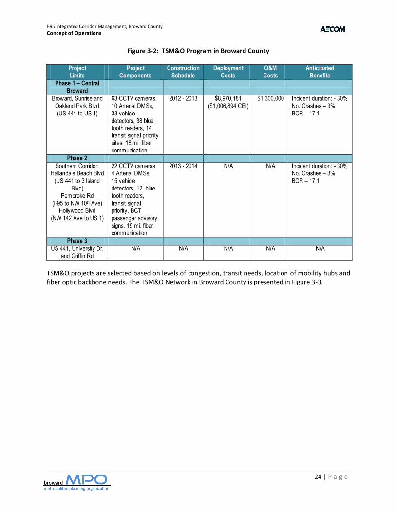
The limited access facilities deployed, operated and maintained by the FDOT District 4 Traffic Operations ITS Program include I-95, I-595 and I-75. The TSM&O program to be deployed by FDOT and Broward County to operate and maintain the systems along arterials is summarized in Figure 3-2..
The Southern Corridor (i.e., Hallandale Beach Boulevard, Pembroke Road, Hollywood Boulevard) is the next TSM&O phase being constructed; followed by US 441 (SW 25th Street to Fillmore Street, FY 13/14) and SR 7 (Fillmore Street to Stirling Road, FY 14/15) as part of roadway improvement projects where the TSM&O components are built into the overall construction. There are no other TSM&O projects planned within the five-year plan. Unfunded
I-95 Integrated Corridor Management, Broward County
Concept of Operations
24 | P a g e
Figure 3-2: TSM&O Program in Broward County
Project Limits
Project Components
Construction Schedule
Deployment Costs
O&M Costs
Anticipated Benefits
Phase 1 – Central Broward
Broward, Sunrise and Oakland Park Blvd (US 441 to US 1)
63 CCTV cameras, 10 Arterial DMSs, 33 vehicle detectors, 38 blue tooth readers, 14 transit signal priority sites, 18 mi. fiber communication
2012 - 2013 $8,970,181 ($1,006,894 CEI)
$1,300,000 Incident duration: - 30% No. Crashes – 3% BCR – 17.1
Phase 2
Southern Corridor: Hallandale Beach Blvd
(US 441 to 3 Island Blvd)
Pembroke Rd (I-95 to NW 10th Ave)
Hollywood Blvd (NW 142 Ave to US 1)
22 CCTV cameras 4 Arterial DMSs, 15 vehicle detectors, 12 blue tooth readers, transit signal priority, BCT passenger advisory signs, 19 mi. fiber communication
2013 - 2014 N/A N/A Incident duration: - 30% No. Crashes – 3% BCR – 17.1
Phase 3
US 441, University Dr. and Griffin Rd
N/A N/A N/A N/A N/A
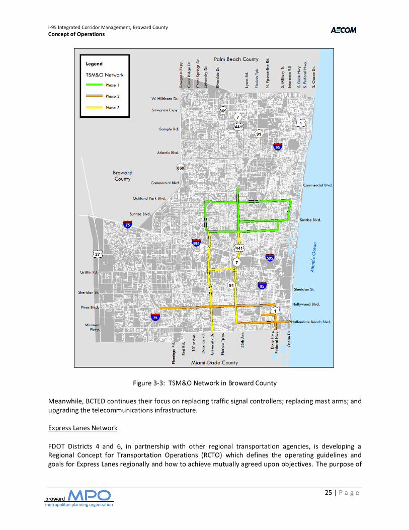
TSM&O projects are selected based on levels of congestion, transit needs, location of mobility hubs and fiber optic backbone needs. The TSM&O Network in Broward County is presented in Figure 3-3.
I-95 Integrated Corridor Management, Broward County
Concept of Operations
25 | P a g e
Figure 3-3: TSM&O Network in Broward County Meanwhile, BCTED continues their focus on replacing traffic signal controllers; replacing mast arms; and upgrading the telecommunications infrastructure. Express Lanes Network
FDOT Districts 4 and 6, in partnership with other regional transportation agencies, is developing a Regional Concept for Transportation Operations (RCTO) which defines the operating guidelines and goals for Express Lanes regionally and how to achieve mutually agreed upon objectives. The purpose of
I-95 Integrated Corridor Management, Broward County
Concept of Operations
26 | P a g e
the RCTO is to be used for the development of the emerging regional network of Express Lane (EL) facilities in Southeast Florida. The RCTO is needed for several reasons, including:
Ensures that Express Lane corridors function seamlessly together Enhances regional mobility Establishes performance metrics Sets institutional arrangements between partners
Initial key topics of the RCTO have been identified, including:
RCTO purpose vs Express Lane corridor specific ConOps Identification of key stakeholders How to administer a multi-agency, regional Express Lane Network Define policy, technical and institutional issues Compliance with ITS architectures Establish performance targets for the Express Lane Network Include mobility related goals from long range transportation plans
Following an extensive outreach process focused on collaboration, a final RCTO document will be approved and agreed upon by all partners that resolve the policy, technical and institutional issues associated with a regional Express Lanes Network in Southeast Florida; defining the roles and responsibilities of participating agencies and partners.
Toll Road Network The Florida Turnpike Enterprise operates the Florida Turnpike and Sawgrass Expressway within Broward County. The Miami-Dade Expressway Authority operates five toll roads within Miami-Dade County. Other than the Florida Turnpike, there are no other toll roads within Palm Beach County. Bus Transit Network BCT provides north-south bus service along the following routes within Broward County:
95 Express: 95 Express Bus Service provides free commuter park and ride locations, and travel along the major interstate highways to Miami-Dade County on weekdays during morning and afternoon peak travel hours. These routes include the following: 95 Express Hollywood, 95 Express Miramar and 95 Express Pembroke Pines. In addition, MDT provides 95 Express service connecting Broward Boulevard and Sheridan Street to Downtown Miami.
The Breeze: The Breeze service has limited stops along the route at major intersections only, on
weekdays every 30 minutes during morning and afternoon peak travel hours. These routes include the following: 441 Breeze, University Breeze, and US 1 Breeze.
BCT Fixed Routes: Fixed routes provide connections to the multimodal transportation network,
as well as system wide connections at four transfer terminals. The continuous north-south routes within Broward County include the following: BCT Route 1, BCT Route 18
I-95 Integrated Corridor Management, Broward County
Concept of Operations
27 | P a g e
Rail Transit Network
Tri-Rail is a commuter rail line linking Miami, Fort Lauderdale, and West Palm Beach. The 70.9-mile-long system has 18 stations along the Southeast Florida coast. The system connects directly to Amtrak at numerous stations, and the Metrorail in Hialeah (Miami) at the Tri-Rail and Metrorail Transfer Station. By late-2013, it will connect with both systems at the Miami Central Station at Miami International Airport.
A second Tri-Rail line, on the Florida East Coast Railway corridor, is currently in the planning stages. The line is expected to extend Tri-Rail service north to Jupiter, Florida, and south through Downtown Fort Lauderdale, terminating at Government Center in Downtown Miami, as well as numerous intermediate cities such as Hollywood, and inner city Miami neighborhoods.
Vanpool Service A vanpool is made up of 5 - 15 people who commute together in a passenger van. One or more of the members of the group volunteers to drive with each rider sharing the cost of operating the van. The main driver may take the van home and use it for personal reasons. In addition, registered vanpools are eligible for using the 95 Express for free. Currently, there are only 13 registered vanpools using the 95 Express in Miami. Park-and-Ride Lots FDOT has built, and currently operates park & ride lots, along I-95 at several locations including the Golden Glades Interchange (Miami-Dade County), Sheridan Street (co-located with Tri-Rail in Broward County), Broward Boulevard (co-located with Tri-Rail in Broward County), Commercial Boulevard (Broward County), Cypress Creek Road (co-located with Tri-Rail in Broward County), and Congress Avenue (Palm Beach County). Pedestrian/Bicycle Network
The Broward MPO continues to play a leadership role in implementing Complete Streets in Broward County. The vision is to create a safe and efficient transportation network that promotes the health and mobility of all residents and visitors by providing high quality multi-modal (pedestrian, bicycle, transit and automobile) access throughout Broward. The Broward MPO endorsed the Complete Streets Guidelines on July 12, 2012 to facilitate and assist local governments in the implementation of Complete Streets. It serves as a template that can be adopted, modified, customized, or expanded based on each community’s needs and desires. The Technical Advisory Committee (TAC) created a “Model Policy Taskforce” and “Model Plan Taskforce” to develop a Complete Streets model Policy and a model Plan. The model Policy and model Plan will guide local governments in revising internal policies and regulations to help implement Complete Streets. They will also help identify and prioritize Complete Streets corridors, leading to the funding and construction of projects.
In addition, two demonstration projects to illustrate principles and measure the benefits of a “Complete Street” have been identified. A “Complete Street” in a suburban area may look different than a “Complete Street" in the urban core, but both are designed with the same principles. Taking this into account, the two demonstration projects selected for analysis are: Hollywood Blvd. – 26 Ave to Dixie Hwy (Urban setting) and Sunset Strip – NW 72 Ave to NW 19 St (Suburban setting). Both corridors
I-95 Integrated Corridor Management, Broward County
Concept of Operations
28 | P a g e
accommodate all modes of transportation. It is the intent of the Broward MPO to partner with the municipalities to implement Complete Streets projects.
3.3.2. Traffic Generators and Events The following is a partial list of events that generally occur annually and impact the I-95 Corridor. These events typically have custom traffic control and special transit service.
Dolphins Cycling Challenger Toys in the Sun Run MLK Day Parade Winter Fest Boat Parade Pines Day Parade Funeral Precessions
In addition, there have been evacuation events for a series of hurricanes that hit the eastern coast of Florida during 2005 - 2007. I-95 was one of the hurricane evacuation routes. 3.4. Corridor Management Tactics The following are descriptions of travel management tactics within the I-95 Corridor. Coordinated DMS Operation FDOT operates DMSs along I-95, I-595 and I-75 and the arterial streets approaching the interstates within the Corridor. Additional DMSs are planned along the arterial streets as part of the TSM&O program. FDOT operates the DMSs from the SMART SunGuide TMC. Sharing of CCTV Images among Public Agencies FHP and BCTED have real-time access to images from FDOT freeway cameras. This assists these agencies in managing the freeway and arterial signal system by viewing field operations in real-time. South East Florida Regional TMC Operations Committee
The South East Florida Regional TMC Operations Committee (SEFRTOC) was formed in 2006 by the South Florida Regional ITS Coalition, an organization that brings together municipal, county, regional and state agencies to ensure compatible implementation and operation of ITS throughout the region. SEFRTOC’s mission is to facilitate regional mobility within South East Florida through coordinated TMC operations. They focus on day-to-day operations and establish a regional approach to ITS operations and incident management through coordinated communication, decision-making and planned resource sharing.
SMART SunGuide TMC
The FDOT District 4 SMART SunGuide TMC is a nationally recognized leader in ITS. It operates 24/7 in Broward County as the communication hub for traffic information along I-95, I-75, and I-595 (monitored and maintained by I-595 Express, LLC) as well as I-95 in Palm Beach, Martin, St. Lucie and Indian River

I-95 Integrated Corridor Management, Broward County
Concept of Operations
29 | P a g e
Counties. TMC Operators coordinate with the Road Rangers, Road Watchers, Florida Highway Patrol and
other partners (i.e., FDOT District 6 TMC, Florida's Turnpike Enterprise TMC, and I-595 Express) to determine incident and congestion locations. Real-time traffic information is then made available to the public through Dynamic Message Signs, Highway Advisory Radio, the SMART SunGuide website, and Florida’s 511 Traveler Information System.
The control room within the TMC includes 22 workstations, a large video wall and projections of relevant data, performance measures, and graphics on the side and rear walls. Of the 22 workstations, 10 are dedicated to FDOT ITS operations, 4 are dedicated to BCTED signal system operations, 3 are dedicated to I-595 operations while the balance are reserved for future applications (e.g., express lanes, ramp metering, TSM&O). The video wall includes real-time performance metrics (e.g., incident management, equipment malfunctions, fiber optic connectivity, signal system map, etc.) while projections provide real-time information on speed profiles along the interstate highways, incident data and weather information.
3.5. ITS Assets The following is a description of ITS Assets being used for travel management within the I-95 Corridor. 3.5.1 FDOT Freeway Management System The freeway management system is operated from the SMART SunGuide TMC located at 2300 West Commercial Boulevard. All equipment is monitored and controlled from the TMC via the SunGuide central software. Within Broward County, the SMART SunGuide ITS infrastructure includes:
79 CCTV Cameras 28 Dynamic Message Signs (Interstate Highway) 36 Arterial Dynamic Message Signs 208 Vehicle detectors 15 Road Ranger trucks operating each weekday 2 Severe Incident Response Vehicles (SIRV) operating each weekday 100 miles of fiber optic communications
The TMC is staffed 24/7. Preventive, corrective and emergency maintenance of ITS field equipment is performed on a scheduled and response basis. 3.5.2. BCTED ITS Assets BCTED is deploying video image detection systems (VIDS) at most of the 1,360 signalized intersections within Broward County. Although the VIDS will help in providing signal timing detection, they will also install CCTV cameras for pan/tilt/zoom capabilities in monitoring their arterial network. As the ITS devices are deployed, BCTED will begin to realize the full potential in applying the ATMS software in terms of new capabilities (e.g., transit signal priority, traffic adaptive) as well as for managing both recurring and non-recurring congestion in supporting ICM operational strategies.
I-95 Integrated Corridor Management, Broward County
Concept of Operations
30 | P a g e
3.5.3. BCT ITS Assets BCT is transitioning from the legacy Orbital AVL system that is UNIX-based to a new system that can operate from a laptop computer. All buses are equipped with the legacy Orbital AVL system and automated voice annuniciators. Approximately half of the fleet has automated passenger counters with plans to equip the entire fleet in the near future as buses are replaced. The current system has limited maintenance diagnostics capabilities, while the new system will be more robust. The new system will use Voice over IP over cellular data. BCT has deployed passenger advisory systems (i.e., next bus signs) along SR 7 (vicinity of Oakland Park Boulevard, Lauderhill Mall) – most next bus signs are solar powered. Plans are to expand the placement of these signs to approximately 500 shelters of the total 5,000 bus stops depending on funding availability. These signs post estimated time of arrivals (ETAs) and have voice announcements, using cellular communications, every minute within five minutes of bus arrivals. The system uses AVL and speed measurements to predict ETAs. It is accurate and embraced by the local community. They have not experienced significant vandalism, largely attributed to community support of the project since the turn-on of the system in June 2009. BCT has plans to install AVL on paratransit vehicles. Currently, there are no plans to install AVL on community shuttles; however, some cities have inquired about implementing passenger advisory signs at their bus stops. BCT does not have current plans to relocate their AVL operations to the SMART SunGuide TMC. However, they would like to keep the option open in using it as a back-up facility during emergencies. Interoperatable electronic fare payment system, between Tri-Rail and BCT, MDT and Palm Tran, is dependent on each transit property complying with the ISO 1443 standard and agreeing to common business rules for back-office operations. BCT fare collection boxes are ready for smart cards. A common fare payment system is anticipated within the next five years. SunPass integration is more of a challenge as the SunPass sticker / transponder is adhered to the vehicle windshield and is less portable. BCT uses 2-3 dispatchers based in the Building 3 operations center at the Copans Road Headquarters facility. BCT buses are equipped with CCTV cameras (i.e., 4 CCTV cameras per bus) and a dual-mode radio system to monitor buses for passenger and driver safety and security. This was funded through Homeland Security funding. It is possible that they may place CCTV cameras at selective bus shelters, particularly those that already have cellular communications via the next bus signs. There are also some discussions, between FDOT and BCT, in using CCTV cameras for monitoring security at the bus stops as part of the TSM&O program. BCT’s ITS program uses an open architecture; is modular to accept new technologies; and has a communications architecture which is not dependent on radio or cellular. They are considering migrating to a mesh network in the future. Google.transit provides a tool for scheduling transit trips. Real-time tracking of BCT buses will soon be available on the BCT web site with real-time information transmitted to cell phones.
I-95 Integrated Corridor Management, Broward County
Concept of Operations
31 | P a g e
Schedule integration of bus-to-bus and bus-to-train (i.e., “connection protection”) is managed through scheduling rather than technology. There are currently no specific policies or procedures in place for ensuring transfer schedule integration. BCT will be working on the maintenance module of the new AVL system to provide maintenance alarms, tickets and status reports. The current Orbital system has limited capabilities in this area. 3.5.4. SFRTA ITS Assets SFRTA is planning to emulate the ITS initiatives being developed and implemented by the three local bus operating agencies (i.e., MDT, BCT, Palm Tran). Specifically, they would mimic the requirements of the electronic fare payment system (e.g., smart cards, automatic passenger counters, etc). SFRTA is planning to piggyback on the other transit agencies in implementing ITS devices on their fleet of shuttle buses as well as smart cards. They are not looking to take the lead due to funding constraints. SFRTA is planning to replace the legacy Geo-Focus system with another system that is more robust. The Geo-Focus system is proprietary; provides no confirmation of actions; and is no longer being supported. The new system should combine the following messages: date, time, track assignment, estimated time of arrival and emergency information. This initiative is currently unfunded. SFRTA plans to continue to operate from the Hialeah Yard in monitoring their 72 miles of track. Security is monitored on trains using CCTV cameras. They desire a single system to be used in monitoring security on trains and at stations using wireless communications. Park & Ride lots are owned and operated by FDOT; railroad crossings are managed by CSXT. 3.6. Proposed Near-Term Network Improvements Several improvement projects have been funded that will have direct impact on the I-95 ICM, including the following: Express Lanes Expansion
o 95 Express, Phase 2, Golden Glades Interchange (Miami-Dade County) to Broward Boulevard (Broward County), under construction
o 95 Express, Phase 3, Broward Boulevard (Broward County) to Linton Road (Palm Beach County), under development
o I-595 Reversible Express Lanes, under construction as part of a public-private partnership for corridor wide improvements
o I-75 Express Lanes, under development for the north-south segment
I-95 Ramp Metering – currently being considered as part of a feasibility study
Broward County Signal System – Phased implementation of a fiber optic communications system to replace the existing copper system
I-95 Integrated Corridor Management, Broward County
Concept of Operations
32 | P a g e
3.7. Current Network - Based Institutional Characteristics The institutional fabric within the I-95 ICM Corridor is multi-agency, multi-functional, and multi-modal. Moreover, the authority for transportation-related decision making is dispersed among several different agencies, including FDOT, BCTED, BCT, SFRTA, FHP and FTE. Additionally, agencies of the US Government (e.g., FHWA, Federal Transit Administration, Department of Homeland Security) and their rules and regulations also impact the operations within the Corridor. The management and operations of the various networks (and the supporting ITS-based systems) have tended to be “stove-piped,” leaving the need for better optimizing communications between the transportation networks and their operators, with the exception of coordination during major events and incidents. It is assumed that the ICM central control/server deployments should be at located the SMART SunGuide TMC. The Corridor Stakeholder decision-makers will need to continue to improve institutional cohesiveness for further implementation of corridor operational technologies and management strategies. 3.7.1. Institutional Agreements The foundation agreement that started regional ITS cooperation is the South Florida ITS Coalition which commenced in 2006 and continues to be active through the South East Florida Regional TMC Operations Committee (SEFRTOC). In addition, there are institutional agreements related to freeway management software sharing, shared facility use for collocated central command, communication sharing, and media relations. 3.7.2. Stakeholder Institutional Challenges Other specific institutional-related obstacles that will effect operation of the I-95 ICM include:
Current jurisdictional policies don’t allow recommendation of specific routes to be communicated to travelers (for various reasons, including neighborhoods not wanting highway traffic on their local streets and liability related to diversion)
Current institutional standard operating procedures discourage diversion off freeways onto
arterials (for various reasons, including heavy arterial congestion within local municipalities) 3.8. Regional ITS Architecture Review The Southeast Florida Regional ITS Architecture is a roadmap for transportation systems integration in South East Florida over the next 20 years. The South East Florida Regional ITS Architecture has been developed through a cooperative effort by the region's transportation agencies, covering all modes. The initial regional ITS architecture was developed from the existing ITS architecture and documentation gathered from stakeholders. This final version of the regional ITS architecture takes into account input from stakeholder workshops conducted in 2005. There have been no subsequent updates of the architecture to directly address the TSM&O or ICM program. However, the Statewide and Regional ITS Architectures represent a shared vision of how each agency’s systems will work together in the future, sharing information and resources to provide a safer, more efficient, and more effective transportation system for travelers in the State.
I-95 Integrated Corridor Management, Broward County
Concept of Operations
33 | P a g e
The Statewide and Regional ITS Architectures have a time horizon of up to twenty years with particular focus on those transportation elements likely to be implemented during the next ten years. The ITS architecture covers the broad spectrum of ITS, including Traffic Management, Transit Management, Traveler Information, Maintenance and Construction, Emergency Management, and Archived Data Management over this time horizon. The “Guideline for Implementation of Rule 940 in Florida” requires the statewide and regional ITS architecture be updated on an as-needed basis. The general rule of thumb is to update the document every three to five years. The South East Florida Regional ITS Architecture was last updated on March 8, 2010 to include the necessary market packages for the deployment of the I-95 Express Project. It may be necessary to provide further updates to the ITS Architecture to reflect the I-95 ICM project. 3.9. Individual Network and Corridor Challenges and Needs This section summarizes the problems, issues and needs of the individual networks and the corridor as a whole. Using the inventory information and other gathered data, coupled with stakeholder discussions, this section addresses operational, technical, and, institutional deficiencies and constraints, As such, it provides insight into the types of problems being faced in the I-95 Corridor. Within the I-95 Corridor, the challenges in efficient movement of people and goods can be classified in terms of agency coordination, available capacity and proactive operational and control strategies. 3.9.1. Network Challenges Agency Coordination: First, the Corridor encompasses multiple modes of transportation and a variety of facilities. It also encompasses multiple operating agencies with various responsibilities for providing transportation services. These operating agencies include a state department of transportation, county traffic signal system, county bus service, regional transportation authority (rail), a statewide toll enterprise, a metropolitan planning organization and a large number of local emergency service providers. While the various agencies generally operate in a cooperative manner, there are limited systems and tools for integrated coordinated operation. One example where data is exchanged is between FDOT, the Broward County 911 system, and FHP. The FDOT District 4 ITS central system receives traffic incident information from the 911 system related to incidents, events, or other actions. There is not, however, a Corridor-wide automated mechanism for improved sharing of data, control strategies, and response plans. For example, a major incident may occur on a freeway and block travel lanes for an hour or more. Drivers may reroute based on information from Dynamic Message Signs (DMS) or from 511. There exists an opportunity for a modal shift to transit, a travel schedule shift, or a route shift if there is a mechanism in place for the affected agencies to act. Even with recurrent congestion, there exists an opportunity for modal, schedule, or route shifts with exchange of information among agencies along with communication to travelers. Such exchange of information and an action plan can better balance available capacity either in time or space. In either case - recurrent or non-recurrent congestion - agencies would be able to manage travel in a more coordinated manner with improved exchange of information and a coordinated action plan taking into account available capacity from all modes. Available Capacity: Second, the Corridor represents a highly-developed, urbanized area. As such, there is limited right-of-way remaining to expand the freeway and arterial streets. Therefore, the vehicle
I-95 Integrated Corridor Management, Broward County
Concept of Operations
34 | P a g e
capacity is set, and the ability to handle future demand increases relies on moving more people on the given modes and effectively utilizing the existing capacity in real-time as both demand and capacity fluctuate. Proactive Operational and Control Strategies: Third, maintaining mobility and safety in the Corridor will require proactive operational and control strategies implemented in an integrated manner among the agencies in the Corridor. Whether it is responding to the high travel demand each day or responding to special and planned events in the Corridor, there is a need to coordinate available capacity to match changes in demand. Furthermore, traveler information should be provided to inform users of travel alternatives to optimize their trips. While the principal mobility challenge in the Corridor is the daily traffic demand, there are a significant number of special events at venues in or near the Corridor that add additional challenges for mobility, safety, and way-finding. 3.9.2. Network Needs Many of the operational deficiencies within the I-95 Corridor have already been discussed. Specific examples of additional needs relating to separate networks, as well as the Corridor as a whole, are discussed below. Arterial Network Needs
Optimization / retiming of traffic signals – especially on established detour routes within the Corridor
Signal systems that better react to current travel conditions (rather than time-of-day); e.g., deployment of traffic responsive signal systems along arterials throughout the corridor; collection and use of real-time traffic conditions along arterials (volume data is needed along with speed data).
Increase BCTED access to 911 / Emergency CAD data to better manage signal system based on incidents effecting traffic on arterials
Improved incident management policies for incidents on arterials – different than freeways.
Freeway Network Needs
Increased sharing of existing freeway travel speed data to other agency systems Transit Network Needs
Signal priority capability for bus and rail transit Increased coordination between BCT and BCTED for management and public information
distribution relating to transit line closures Ability to accurately measure bus and rail ridership in real-time Need ability to alert (not just broadcast) customers about service disruptions, both pre-trip and
en-route (probably via wireless medium, e.g., cell phones or PDAs) Need better parking management at park-&-ride facilities Increased information sharing within BCT and Tri-Rail so that bus operators know about
problems on rail, and vice-versa
I-95 Integrated Corridor Management, Broward County
Concept of Operations
35 | P a g e
Incident Management / Field Operation Needs
Need for interoperable communication between incident responders of all agencies Multi-Network Needs
Delivering freeway travel times and incident messages to travelers along arterials prior to getting on the freeway
Ability to effectively communicate diversion routes to travelers who may be unaccustomed to alternate routes
Proven systems for predicting operating conditions in order to make operational decisions Ability to measure mode change when put into effect as a traffic management tool Increased sharing of video images Increased sharing of travel conditions along all networks, so that information about problems on
one network can be relayed to travelers who seek to transfer from another network Ability to effectively relay travel time and/or delay information for all modes to travelers en-
route so that travel decisions can be made Need for real-time volume data on all modes, not just flow data Integration of existing bus location data (for flow information) to freeway systems Public outreach and education to traveling public who is unaccustomed to use of alternate
modes of travel Institutional / Coordination Needs
There is a need for formalized agreements to define data and video sharing protocol between partner agencies
There is a need for formalized standard operating procedures for multi-agency shared control of ITS devices through integrated systems
As an extension of the TSM&O program, well defined and agreed-upon performance measures are needed for determining the effectiveness of multi/cross-network operational management
There needs to be increased coordination between agencies about what real-time data is being collected and how it can be made available
Increased focus of Corridor Stakeholders for integration of existing system, rather than deployment of additional non-integrated systems
Acquiring decision-maker/political support for ICM concepts, specifically the MPO and County Commission
3.10. Potential for ICM in the Corridor The ICM concept appears to be a viable solution for the I-95 Corridor within Broward County. The needs and goals, as detailed in Section 3.8 above, related transportation operations within the Corridor, are most likely to be met only with operations within each of the separate transportation networks to be coordinated. The I-95 Corridor consists of multiple independent networks: Freeway, Express Lanes, Toll Roads. Arterials, Bus and Rail. Each of these corridor networks are experiencing congestion to some extent during peak hours. “Integrated Corridor Management” focuses on the operational, institutional, and technical coordination of multiple transportation networks and cross-network connections comprising a corridor. Moreover,
I-95 Integrated Corridor Management, Broward County
Concept of Operations
36 | P a g e
ICM can encompass several activities which address the problems and needs identified in the previous section (e.g., integrated policy among stakeholders, communications among network operators and stakeholders, improving the efficiency of cross-network junctions and interfaces, real-time traffic and transit monitoring, real-time information distribution, congestion management, incident management, public awareness programs, and transportation pricing and payment). Multiple areas and strategies are identified that would assist in operating the corridor in a more efficient and safe manner and have a positive impact to the overall economy of the region. The first major area deals with information sharing both with the public and among agencies. A “Center-to-Center” program to share information could be used for better informing the public of the operations of the corridor and the availability and impact of different modes. The corridor could provide comparative travel time across modes, so that travelers can make informed decisions about trips they are about to make. This would include the ability to collect and distribute arterial travel time data via various media. One area that is needed is pre-planned response plans and a decision support tool to assist with the on-going operations of the corridor. This decision support tool would be integrated with the various agencies, and provide response plan requests. The agencies would identify hot spots where recurring incidents and special events occur, and develop responses that are coordinated and agreed upon by the agencies. One of the deficiencies that needs to be addressed – and a specific attribute of the Regional ITS Architecture – involves the exchange and sharing of real-time data. With real-time data and video among the networks, each network could monitor the conditions of adjacent networks to anticipate when travelers may shift to their network and take appropriate actions. Moreover, real-time condition information would provide the foundation for corridor-wide traveler information. A Regional Data and Video Communication System should be designed that would serve as the central distribution point for sharing video among corridor agencies. Currently several agencies share some of their video images. Another element of ICM that is needed is outreach and marketing to the public and major employers within the corridor. Outreach to major employers should be considered to provide customized traveler information to them. Another potential element of ICM involves enhanced mobility opportunities, including shifts to alternate routes and modes. Currently, any shifts that do occur are based on traveler knowledge and past experience. Using integrated real-time information, the various networks working as a corridor could influence traveler network shifts; especially promoting, when appropriate, shifts to the rail network with its unused capacity. DMSs deployed among the networks could be operationally integrated and messages could be used to provide travelers condition information on all corridor networks so that each traveler can take appropriate action if one or more of the corridor’s network’s performance is compromised. More can be done with corridor trip travel times to influence traveler shifts, or staggering of the start of travel. For special events, the DMSs could be used to direct event attendees to specific event corridor transportation services. There is potential to enhance current and near-term operations by implementing selected ICM and cross-network strategies. All of these enhancements would not be possible from an independent network operational perspective. The potential strategies identified above indicate that further investigation and design concerning integrated corridor management is needed.

I-95 Integrated Corridor Management, Broward County
Concept of Operations
37 | P a g e
3.11. Corridor Vision The I-95 ICM Project would be a collaborative effort between FDOT, BCTED, BCT, FHP, SFRTA and other partners within the Tri-County region. The following corridor vision was borrowed from the Dallas ICM project and should be modified to reflect the I-95 ICM stakeholders within the Southeast Florida region. “Operate the I-95 Corridor in a true multimodal, integrated, efficient, and safe fashion where the focus is on the transportation customer”.
I-95 Integrated Corridor Management, Broward County
Concept of Operations
38 | P a g e
4. ICM System Operational Concept This chapter describes the I-95 ICM operational concept within Broward County, recognizing that ICM would need to span all three counties (i.e., Miami-Dade, Broward, Palm Beach) to maximize its effectiveness. The proposed ICM concept explains how operations are expected to work after ICM implementation, and identifies the responsibilities of the various stakeholders for making this happen. The chapter defines the ICM goals and objectives (Section 4.1); the operational approaches and strategies to be implemented in response to the Corridor problems and needs (Section 4.2); proposed changes to the current technical, operational, and institutional situation within the corridor providing a sense of the overall scope for the ICM concept; alignment of the ICM with the Regional ITS Architecture (Section 4.6); and corridor performance measures and metrics (Section 4.9). The system concept also addresses the key system implementation issues including how they may be resolved (Section 4.7). An initial mapping (i.e., traceability) of each selected ICM strategy to the goal(s) and the corresponding need(s) it addresses is also included within the chapter. This chapter provides the traceability from vision, goals and objectives through to assets and strategies. 4.1. Corridor Goals and Objectives The Vision Statement for the Corridor is “Operate the I-95 Corridor in a true multimodal, integrated, efficient, and safe fashion where the focus is on the transportation customer.” Within approximately the next five years, the corridor would offer travelers the opportunity to make seamless and convenient shifts among modes and among the corridor’s networks to complete their trips. Enhanced mobility for people, goods, services, and information would be achieved by further enhancing current levels of existing interoperability between field elements and through continued collaboration and cooperation among the corridor’s institutional partners and their native functional environments or systems. The I-95 ICM is therefore focused on improving person- and vehicle-throughput, productivity, connectivity, safety, environmental compatibility, and enhancing accessibility to reach destination points in a reliable and timely manner. Using the Vision Statement as a starting point, the primary Goals and Objectives for the I-95 ICM are presented below.
1. Goal: The corridor’s multi-modal approach should improve accessibility for corridor travelers to travel options and attain an enhanced level of mobility. The objectives include the following: Reduce travel time for commuters within the corridor Increase transit ridership within the corridor Increase the use of HOVs (carpools and vanpools) for commuters Increase person and vehicle throughput within the corridor on general purpose and express
lanes Increase person and vehicle throughput on arterials Reduce delay time for corridor travel on the networks (e.g., I-95 and arterials) Increase percentage share of telecommuters from corridor commuter market Increase the use of established and effective Transportation Demand Management (TDM)
programs Promote development to encourage the use of transit (especially BRT)
2. Goal: The corridor’s travelers should have the informational tools to make smart travel choices
within the corridor. The objectives include the following:
I-95 Integrated Corridor Management, Broward County
Concept of Operations
39 | P a g e
Improve collection and dissemination of arterial network information Collect and process data on the operational condition/status of all corridor networks,
including comparative travel times between major origins and destinations; construction, detours and other planned road work; occurrence and location of incidents; expected delays; and number of parking spaces available at Park & Ride lots
Disseminate comprehensive, real-time, and accurate information to travelers within the corridor by means of multiple media (e.g., smartphone, computer, PDA, TV, DMSs, ‘Next Bus’ informational signs)
Make available archived historical data to travelers Achieve a high level of 511 call volume and Web use Achieve high overall satisfaction with the 511 system
3. Goal: The corridor should be managed to improve operations of goods movements along the
Virtual Freight Network (VFN) in a collaborative and coordinated way. The objectives include the following:
Provide useful information to truck dispatchers regarding traveler information, truck
restrictions (e.g., weight, height, geometrics), terminal wait times, queues, eliminating “bob tail” (empties) moves, and logistics management information.
Consider the multiple languages of the truckers and the need to keep the technologies simple and to not distract truckers while driving. Therefore, the dispatchers should be the targeted audience for technologies.
Technology improvements should address: (1) drayage optimization (short truck trips from the port to local destinations); (2) freight dynamic routing; (3) increasing emergency preparedness and response efficiency; and (4) data integration and dissemination.
Address travel time reliability along the VFN in terms of incident management along the freeways and active traffic management along the arterials.
Provide a menu of user services to freight companies including: travel time information, dynamic routing, traffic plans by time-of-day, incident alerts, and predictive tools to estimate the duration that traffic will be disrupted by incidents by time-of-day to post on the DMSs and 511.
4. Goal: The corridor’s safety record should be enhanced through an integrated multi-modal approach. The objectives include the following: Reduce primary incident rates Reduce secondary incidents Reduce injury rates Reduce fatality rates
5. Goal: The corridor’s institutional partners should employ an integrated approach through a
corridor-wide perspective to resolve problems. The objectives include the following: Improve level of institutional coordination among stakeholders by developing and executing
a memorandum of understanding (MOU) among I-95 ICM corridor partners Strengthen existing communication linkages among all corridor institutional stakeholders
and establish new communication linkages where appropriate (e.g., business/industrial parks along the corridor)
I-95 Integrated Corridor Management, Broward County
Concept of Operations
40 | P a g e
Enhance a regional/joint operations concept throughout the corridor Balance the needs of through traffic and local communities by coordinating construction
and overall mitigation management on interstate highways and arterials
6. Goal: The corridor’s networks should be managed holistically under both normal operating and incident/event conditions in a collaborative and coordinated way. The objectives include the following: Establish/enhance joint agency action plans to respond to congestion especially at I-
95/arterial network interfaces and at recurring choke points Develop/improve methods for incident and event management (e.g., data sharing) Reduce overall incident clearance times Identify means of enhancing corridor management across all networks (e.g., implement
transit signal priority on selected components of arterial network)
4.2. User Needs User needs identify the high-level ICM system needs; these user needs are developed to focus on the operational aspects of the ICM, and defining the functional requirements of the proposed ICM system. These needs are based upon the system goals and objectives provided above, and the future operational conditions and scenarios defined in Section 5. The user needs will be utilized during the requirements development of the next phase of the systems engineering process to develop the high-level system requirements document. The ICMS implementation guidance provided by the U.S. DOT defined the following five ICMS approaches:
1. Information sharing and distribution. 2. Improve operational efficiency of network junctions and interfaces. 3. Accommodate and promote cross-network route and modal shifts. 4. Manage capacity, or the demand relationship within corridor, in “real-time” for the short term. 5. Manage capacity, or the demand relationship within corridor, for the long term.
4.2.1. Use Cases Use cases are a technique for capturing the functional requirements of a system. Use cases work by describing the typical interactions between the users of a system and the system itself, by providing a narrative of how a system is used. Utilizing the scenarios developed during the concept of operations phase of the ICM project, use cases were developed to tie the scenarios together by a common user goal. The goal of the typical user (traveler) is to make a trip from one location to another. This trip requires the user to plan, understand the current conditions of the transportation network, and make changes during the trip if the conditions of the network change. During the high-level requirements development, each Use Case will be expanded upon to discuss the dependencies, interfaces, and conditions.
I-95 Integrated Corridor Management, Broward County
Concept of Operations
41 | P a g e
4.2.2 Use Case Development Utilizing the Use Cases from the section above, the following User Needs were developed for the ICM program:
1. Need for improved communication among agencies – To ensure that actions taken by one corridor agency do not have unintended consequences on the corridor, or other agencies within the corridor, the agencies need to communicate interactively with each other in order to plan and execute actions that are not normal operation procedures. The communication does not need to be continuous, but does need to occur in a timely manner when actions are about to begin.
2. Need to provide freight dispatchers with real-time traffic information – Need to apply an ICM
system to change truckers’ behavior to re-optimize their decisions. In order to achieve this we need to determine: (1) what medium should be used to transmit data; (2) what data needs to be transmitted; (3) how is this data being used by the freight movement user community; and (4) performance outcomes. Need to identify the 20% of information that 80% of the truckers will use (Pareto Principle).
3. Need to monitor the status of the physical transportation infrastructure – Agency operators
need to monitor the status of all devices within the corridor on a real-time or near real-time basis. Knowing which devices are operational will enable them to determine which devices can be used to affect change within the corridor.
4. Need to process information on status of the infrastructure in near-real time – The ICM system
needs to be able to process all of the relevant data and information it receives from the various agencies within the corridor, in order to provide information to operators and travelers which can be used to make informed decisions on actions to be made.
5. Need to update conditions of the infrastructure to the public and other agencies in near-real
time - In order to optimize the corridor operations, the travelers and the agencies need to have up to date information on the current conditions and status of the corridor infrastructure.
6. Need for interactive trip planning – To ensure that travelers within the corridor can make
informed decisions, the corridor agencies need to provide a way to allow travelers to develop plans for a trip. This could include various media, and multi-modes of travel.
7. Need for near-real time information for travelers – In order to optimize the trips that a traveler
makes, they need to have current information provided to them during trips in order to make informed decisions on the their current route and mode.
8. Need to have physical infrastructure coverage – The components for the physical infrastructure
(DMS, CCTV, vehicle detectors, communications network, etc.) within the corridor need to be reliable, available, maintained, extensible, and interoperable. The operators of the corridor need to know the location of all devices and other facilities within the corridor’s network, and their purpose and capabilities. If a device is not operating correctly, the operator needs to know whom to contact to fix the device.

I-95 Integrated Corridor Management, Broward County
Concept of Operations
42 | P a g e
9. Need to collect and store data/ information – The data/ information collected during daily operations of the corridor needs to be stored for analyzing the effectiveness of the corridor strategies and responses, and for modeling.
10. Need to provide pre-agreed incident response plans – The agencies within the corridor need to
have some pre-arranged response plans for incidents within the corridors, these will provide the contacts, roles and responsibilities, and responses for each network within the corridor.
11. Need to coordinate incident responses among agencies – The agencies within the corridor need
to coordinate responses to incidents such that two agencies are not responding to the same incident, and not inadvertently impacted one another.
12. Need to provide multi-modal alternatives for travelers – In order to reduce congestion, and
improve efficiency of the entire corridor, multiple modes and routes need to be available to the traveler. These mode choices need to include alternatives for various levels of income and mobility for the traveler.
13. Need to measure effectiveness of responses – During the response to an event in the corridor,
the operators need to be able to determine if the preplanned response is effective and if the response if having the intended effect. This includes verifying what conditions exist after implementation of a response. If the operators of the systems determine that their response is not effective, they should be able to change components of their response plans and communicate these changes to the other agencies within the corridor, such that they are not inadvertently impacting the other agencies.
14. Need to modify responses during event as conditions change - As an event progresses, the
conditions (such as lanes closed, severity, etc.) will change. The operators should be able to modify the current conditions, and communicate with the others within the corridor of the change. The system needs to also request changes to the current responses as the conditions warrant.
15. Need to request use of infrastructure from third party - During some major incidents and
special events, the current and planned capacity of the infrastructure owned and operated by the agencies may not be sufficient. This requires an interface to multiple third parties (large companies, private parking, van services, etc.) to request service from them or use of their infrastructure during special circumstances.
4.3. Application of ICM Approaches and Strategies In order to determine the strategies to meet the needs, goals, and objectives of the I-95 ICM program, several meetings and workshops are needed to ensure that all stakeholder viewpoints are relayed and considered in the decision-making process. The activities as part of developing this ConOps includes:
Meeting with each stakeholder agency individually to discuss the I-95 ICM, the agency’s needs and potential strategies for meeting the goals
Multiple project I-95 ICM Steering Committee workshops to review the findings of the agency meetings, and to the discuss goals and strategies for the I-95 ICM
I-95 Integrated Corridor Management, Broward County
Concept of Operations
43 | P a g e
Overall, the strategies for meeting the goals fit very well with many of the activities already underway within Broward County through the TSM&O program. From the ICM Strategies discussed, multiple scenarios are considered to decide upon the institutional framework for the corridor, and to ensure that all goals and strategies are documented. The I-95 ICM Steering Committee should participate in workshops and discuss and evaluate each of the scenarios and strategies for the corridor with respect to their potential for achieving the goals, objectives, and needs of the corridor and stakeholders. As this analysis evolves, the following scenarios would be addressed:
Daily Operations (including minor incidents)
Major Incidents (i.e., Freeway, Arterial, Transit Incident) Freight Movement Operations Weather Event
These scenarios and the goals, objectives, and needs of the corridor also guide the selection of the ICM strategies for the I-95 Corridor. As previously noted, the ICM strategies will be developed based on how each goal could be met through ICM deployments and initiatives. As there are many commonalities among the strategies identified, an analysis should be executed to ensure that strategies for one goal does not compete or contradict with other strategies for the corridor. Proposed ICM approach and strategies are summarized below: Information Sharing/ Distribution Manual information sharing (e.g., voice telecommunications, emailing) Automated information sharing (real-time data)
SunPass readers, cell phone probes
Define what real-time information is available from all agencies
Measure response time and incident clearance time
Data mining of CAD systems
Speed and travel time on arterials
System detection for signal system Automated information sharing (real-time video)
Regional video sharing
Need for streaming video (or near streaming) sharing and distribution Information clearinghouse / Information Exchange Network (corridor networks / agencies)
Center-to-Center (C2C) Network
Share information between FDOT, BCTED, BCT, SFRTA along the corridor
Integrated approach to management
A common incident reporting and asset management
Shared control of passive ITS devices such as CCTV cameras
Trade-offs between agencies to improve overall corridor operations Corridor-based ATIS integrated database and distribution
Automated emailing on incidents
Traveler information to PDAs
Subscription based traveler information to PDAs and text capable devices
Web-based trip planner
Traveler information at major sources of employment
Availability of other modes
I-95 Integrated Corridor Management, Broward County
Concept of Operations
44 | P a g e
Linked Websites/ Portal Access to corridor ATIS database by 3rd party traveler information providers En-route traveler information devices (e.g., DMS, HAR, 511, transit Public Address systems) being
used to describe current operational conditions on another network within the corridor
Passenger Information System – Public Address System, DMS at rail & bus stations
Information to motorists on highway with information to the drivers on parking availability/ transit
Expand real-time travel times on DMSs
Expand traveler information distribution infrastructure on arterials
Customers subscription to real-time data on schedule data, amount of delay, etc. – cell phone, PDA – time of day, and location based
Arterial DMSs
Automated downloads A common incident reporting system and asset management (GIS) system
Integrate/ share data from multiple CAD Systems
Measure response time and incident clearance time
Data mining of the CAD Systems
Common Radio system (frequency/ channels) for emergency services
Pre-defined, acceptable detours are needed for certain incident location Decision support tools to model responses – pre-planned, real-time, predictive Signal priority for transit (e.g., extended green times to buses that are operating behind schedule)
Transit traveler information (e.g., real-time train arrival information, pre-trip planning)
Multi-modal electronic payment (Bus/ Rail/ SunPass) Transit hub connection protection Multi-agency / multi - network incident response teams and training exercises
Need for interoperable communications
Radio/ CAD systems
Expand real-time tracking of Road Rangers
Need for better coordination between responders
Need for staging of resources
Need for pre-planning of incident scenarios
Training of agencies on common approach
Outreach to relay availability of existing courses
Coordinated / consistent policies for incident response (e.g., towing policies, response times) Use of dynamic lanes assignment to increase available capacity in case of accidents on the freeway
and increase amount of green in the direction of the accident. Accommodate / Promote Cross-Network Route & Modal Shifts Modeling of mode shift
Determine benefits and impact Modify arterial transit signal priority timing to accommodate traffic shifting from freeway
Retiming of traffic signals
Modify arterial signal timing to accommodate traffic shifting from freeway Facilitating mode shift from roadways to transit (or vice-versa) via en-route traveler information
devices (e.g., DMS, HAR, 511) to advise motorists of, e.g.: congestion ahead, directions to Tri-Rail stations, and real-time information on the number of parking spaces available.
I-95 Integrated Corridor Management, Broward County
Concept of Operations
45 | P a g e
Agree to how mode change is measured
Evaluate if travelers saved time by mode change
Traveler information to PDAs
Manage Capacity–Demand Relationship – Real-time / Short-Term Add transit capacity by adjusting headways and number of vehicles
Deploy model to evaluate when this is worth the expense Add capacity at parking lots
Work with local businesses in the Corridor to make parking capacity available
Shuttles from temporary parking lots to/from transit stations Coordinate scheduled maintenance and construction activities Consider modifying Express Lane restrictions
Remove express lane restrictions during major incidents and special events
Variable speed limits Restrict / re-route commercial traffic
Coordinate with major Commercial Vehicle Operator hubs in the area
Convert regular lanes to truck-only.
Variable truck restrictions (lane, speed, network, time of day) Manage Capacity – Demand Relationship - Long-Term Capacity Oriented Low-cost infrastructure improvements to cross-network linkages and junctions Possible Express Lanes along arterial connections between I-95 and other limited access
expressways Increase/maximize supply
Additional transit - Automatic Passenger Counters
Additional parking
Diversion of vehicles
Re-routing rail transit (e.g., CSXT) to alternative rail network (e.g., FEC) Demand-Oriented Ride-sharing programs Marketing/ advertising
Public outreach/education
Guidelines for flexible work hours, mode shifts, ride sharing
Information at trucking distribution centers 4.4. I-95 ICM Asset Requirements and Needs The corridor agencies and the region have many of the assets needed to implement ICM; however further integration and coordinated response plans are needed. Some coordination does currently occur during special events and major incidents. Also, some integration is already in place. For instance, both the FDOT freeway operations and the BCTED signal operations are co-located at the SMART SunGuide TMC and will include express lanes operations in the near future.
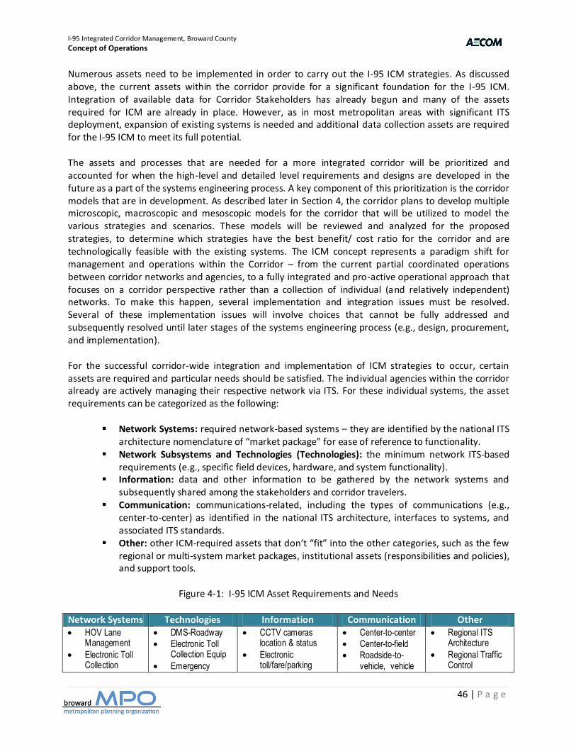
I-95 Integrated Corridor Management, Broward County
Concept of Operations
46 | P a g e
Numerous assets need to be implemented in order to carry out the I-95 ICM strategies. As discussed above, the current assets within the corridor provide for a significant foundation for the I-95 ICM. Integration of available data for Corridor Stakeholders has already begun and many of the assets required for ICM are already in place. However, as in most metropolitan areas with significant ITS deployment, expansion of existing systems is needed and additional data collection assets are required for the I-95 ICM to meet its full potential. The assets and processes that are needed for a more integrated corridor will be prioritized and accounted for when the high-level and detailed level requirements and designs are developed in the future as a part of the systems engineering process. A key component of this prioritization is the corridor models that are in development. As described later in Section 4, the corridor plans to develop multiple microscopic, macroscopic and mesoscopic models for the corridor that will be utilized to model the various strategies and scenarios. These models will be reviewed and analyzed for the proposed strategies, to determine which strategies have the best benefit/ cost ratio for the corridor and are technologically feasible with the existing systems. The ICM concept represents a paradigm shift for management and operations within the Corridor – from the current partial coordinated operations between corridor networks and agencies, to a fully integrated and pro-active operational approach that focuses on a corridor perspective rather than a collection of individual (and relatively independent) networks. To make this happen, several implementation and integration issues must be resolved. Several of these implementation issues will involve choices that cannot be fully addressed and subsequently resolved until later stages of the systems engineering process (e.g., design, procurement, and implementation). For the successful corridor-wide integration and implementation of ICM strategies to occur, certain assets are required and particular needs should be satisfied. The individual agencies within the corridor already are actively managing their respective network via ITS. For these individual systems, the asset requirements can be categorized as the following:
Network Systems: required network-based systems – they are identified by the national ITS architecture nomenclature of “market package” for ease of reference to functionality.
Network Subsystems and Technologies (Technologies): the minimum network ITS-based requirements (e.g., specific field devices, hardware, and system functionality).
Information: data and other information to be gathered by the network systems and subsequently shared among the stakeholders and corridor travelers.
Communication: communications-related, including the types of communications (e.g., center-to-center) as identified in the national ITS architecture, interfaces to systems, and associated ITS standards.
Other: other ICM-required assets that don’t “fit” into the other categories, such as the few regional or multi-system market packages, institutional assets (responsibilities and policies), and support tools.
Figure 4-1: I-95 ICM Asset Requirements and Needs
Network Systems Technologies Information Communication Other HOV Lane
Management
Electronic Toll Collection
DMS-Roadway
Electronic Toll Collection Equip
Emergency
CCTV cameras location & status
Electronic toll/fare/parking
Center-to-center
Center-to-field
Roadside-to-vehicle, vehicle
Regional ITS Architecture
Regional Traffic Control
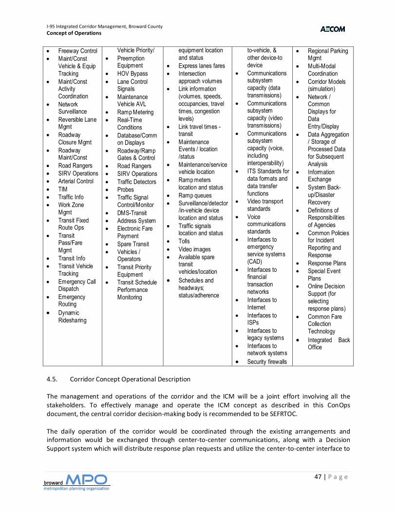
I-95 Integrated Corridor Management, Broward County
Concept of Operations
47 | P a g e
Freeway Control
Maint/Const Vehicle & Equip Tracking
Maint/Const Activity Coordination
Network Surveillance
Reversible Lane Mgmt
Roadway Closure Mgmt
Roadway Maint/Const
Road Rangers
SIRV Operations
Arterial Control
TIM
Traffic Info
Work Zone Mgmt
Transit Fixed Route Ops
Transit Pass/Fare Mgmt
Transit Info
Transit Vehicle Tracking
Emergency Call Dispatch
Emergency Routing
Dynamic Ridesharing
Vehicle Priority/
Preemption Equipment
HOV Bypass
Lane Control Signals
Maintenance Vehicle AVL
Ramp Metering
Real-Time Conditions
Database/Common Displays
Roadway/Ramp Gates & Control
Road Rangers
SIRV Operations
Traffic Detectors
Probes
Traffic Signal Control/Monitor
DMS-Transit
Address System
Electronic Fare Payment
Spare Transit
Vehicles / Operators
Transit Priority Equipment
Transit Schedule Performance Monitoring
equipment location and status
Express lanes fares
Intersection approach volumes
Link information (volumes, speeds, occupancies, travel times, congestion levels)
Link travel times - transit
Maintenance Events / location /status
Maintenance/service vehicle location
Ramp meters location and status
Ramp queues
Surveillance/detector/in-vehicle device location and status
Traffic signals location and status
Tolls
Video images
Available spare transit vehicles/location
Schedules and headways; status/adherence
to-vehicle, & other device-to device
Communications subsystem capacity (data transmissions)
Communications subsystem capacity (video transmissions)
Communications subsystem capacity (voice, including interoperability)
ITS Standards for data formats and data transfer functions
Video transport standards
Voice communications standards
Interfaces to emergency service systems (CAD)
Interfaces to financial transaction networks
Interfaces to Internet
Interfaces to ISPs
Interfaces to legacy systems
Interfaces to network systems
Security firewalls
Regional Parking Mgmt
Multi-Modal Coordination
Corridor Models (simulation)
Network / Common Displays for Data Entry/Display
Data Aggregation / Storage of Processed Data for Subsequent Analysis
Information Exchange
System Back-up/Disaster Recovery
Definitions of Responsibilit ies of Agencies
Common Policies for Incident Reporting and Response
Response Plans
Special Event Plans
Online Decision Support (for selecting response plans)
Common Fare Collection Technology
Integrated Back Office
4.5. Corridor Concept Operational Description The management and operations of the corridor and the ICM will be a joint effort involving all the stakeholders. To effectively manage and operate the ICM concept as described in this ConOps document, the central corridor decision-making body is recommended to be SEFRTOC. The daily operation of the corridor would be coordinated through the existing arrangements and information would be exchanged through center-to-center communications, along with a Decision Support system which will distribute response plan requests and utilize the center-to-center interface to
I-95 Integrated Corridor Management, Broward County
Concept of Operations
48 | P a g e
communicate to the various agency systems. The central point of coordination for the corridor would be the SMART SunGuide TMC with FDOT and BCTED collocated at the facility. All operations among corridor networks and agencies (e.g., activation of specific ICM strategies) would be coordinated via the Decision Support system. SEFRTOC would also investigate and prepare corridor response plans for various scenarios that can be expected to occur within the Corridor. SEFRTOC would be responsible, with the other agency/service operations officers, for configuring the subcommittee with respect to its functions and staffing for all hours of operations. Staff would be assigned by the corridor stakeholders to support daily operations, develop response plans, analyze system deficiencies and needs, and general administration. Performance measurement and monitoring would be the responsibility of SEFRTOC. The agency/service members would accountable to the centralized decision-making body and make reports as the decision making body designates. Communications, systems, and system networks would be integrated to support the virtual corridor command center. Voice, data, video, information, and control would be provided to all agencies based on the adopted protocols and standards for the sharing of information and the distribution of responsibilities. The ICM would support the virtual nature of the corridor by connecting the member agency staff on a real-time basis via communications and other ITS technologies. While all the ICM operational strategies would be available for use, it is envisioned that only a subset of these strategies would be activated at any one time, depending on the operational conditions and events within the corridor. A Virtual TMC would operate the infrastructure of the I-95 ICM. Voice, data, video, information, and control would be provided to all agencies based on the adopted protocols and standards for the sharing of information and the distribution of responsibilities. The Virtual TMC would monitor corridor travel conditions 24/7 and use the response plans, real-time information, and the implemented corridor strategies to address any conditions that present themselves. All supporting staff would know their respective roles and responsibilities and would be aided, when available, by response plans and decision support software. Moreover, the coordinator would be able and authorized to improvise as situations may dictate. Corridor-based traveler information would be made available on 511, Web sites, DMSs, and through the media and 3rd party traveler information providers, presenting corridor trip alternatives complete with current and predicted conditions. Travelers would access or be given real-time corridor information so they can plan or alter aspects their trips such as mode, route choice, or departure time in response to current or predicted corridor conditions. Each traveler would be able to easily make route and modal shifts between networks due to integrated corridor information, integrated fare/parking payment system, and coordinated operations between networks. Travelers would be able to educate themselves about the corridor so they can identify their optimal travel alternatives and obtain the necessary assets (e.g., smart card, available parking) to facilitate their use of corridor alternatives when conditions warrant.
SEFRTOC would conduct desktop scenario sessions to prepare, train and refine response plans for incidents, special events, weather, and evacuations. All the agency/service operations staff would know their respective roles and responsibilities for any of the various situations the corridor may face and would be aided by the Decision Support system and the evaluation model results.
I-95 Integrated Corridor Management, Broward County
Concept of Operations
49 | P a g e
Moreover, agency operations staff would be able and authorized to improvise as situations may dictate. Traveler information via websites, DMS, and through the media and 3rd party traveler information providers would be corridor based, providing information on corridor trip alternatives complete with current and predicted conditions. Travelers would access or be given real-time corridor information so they can plan or alter their trips in response to current or predicted corridor conditions. Each traveler would be able to make route and modal shifts between networks easily due to integrated and real-time corridor information, integrated fare/parking payment system, and coordinated operations between networks. Using one network or another would be dependent on the preferences of the traveler, and not the nuances of each network. Travelers would be able to educate themselves about the corridor so they can identify their optimal travel alternatives and obtain the necessary tools to facilitate their use of corridor alternatives when conditions warrant. The I-95 Corridor would be an integrated transportation system - managed and operated collectively - to maximize its efficiency to corridor travelers. All corridor assets would support the goals and objectives of the corridor, as well as the goals of each individual traveler as their preferences prescribe. The corridor users would recognize the I-95 Corridor as a multimodal, integrated, efficient, and safe transportation system that provides them with multiple viable alternatives that they can select based on their specific travel circumstances and needs. 4.6. Alignment with Regional ITS Architecture The goals and strategies for the Regional ITS Architecture are very similar to the strategies and integration needed for the I-95 ICM, including:
Increase Corridor Throughput Improve travel time reliability Improved incident management Enable intermodal travel decisions
The major focus of the corridor and the region is increased and timely information sharing among agencies and the public. This has already been started through various projects and initiatives and should continue by filling the gaps in the existing ITS communications infrastructure by completing critical system linkages. 4.7. Implementation Issues With regards to strategies and scenarios, several implementation issues are identified. These implementation issues are both technical and political in nature. The technical issues deal with the limitations of technology, and traffic flow. The political issues deal with existing policies and budget issues. The primary implementation issues include the following: Transit Headway – minimum headway of Tri-Rail trains is 20 minutes Limited increase in Tri-Rail capacity may be insufficient for major mode shift during major incidents
and special events. Tri-Rail has maximum length of three cars
I-95 Integrated Corridor Management, Broward County
Concept of Operations
50 | P a g e
Diversion Policies – several of the agencies have policies against diverting traffic from freeway to arterial streets
Full Corridor optimization may not be possible without some changes in current policies. Detour Route Policies – several of the agencies have policies against specifying specific detour
routes Full corridor optimization may not be possible without some changes in current policies. Modeling requirements - Due to the complex nature of the ICM initiative, the modeling effort will be
a prerequisite to prioritizing and finalizing the strategies for ICM. Many strategies chosen initially may be found through modeling to have little to no positive impact
on the corridor Many of the County agencies have limited hours of operations due to funding issues. Response to some corridor scenarios will be time limited in off-hours. Coordination and delegation of authority – some agencies will not allow modification or control of
their assets by others. Responses to some scenarios will require more coordination and may increase time for response. Resource Requirements – many of the operating agencies do not have the additional resources that
may be needed for a corridor operation approach 4.8. I-95 ICM Concept Institutional Framework In developing the institutional framework, many configurations and institutional arrangements should be considered to continue and improve upon a decentralized operational model with a centralized decision making body for cooperation and oversight. The approach for the I-95 ICM is to utilize existing institutional cooperation agreements, and expand on them specifically for the corridor. The management and operations of the corridor and the ICM should be a joint effort involving all the stakeholders. To effectively manage and operate the ICM concept as described in this ConOps document, SEFRTOC is recommended as the operations committee. The I-95 ICM Subcommittee would be the central decision-making body for the corridor, managing the distribution of responsibilities, the sharing of control, and related functions among the corridor agencies. The I-95 ICM Subcommittee would be responsible for establishing the necessary inter-agency and service agreements, budget development, project initiation and selection, corridor operations policies and procedures, and overall administration. As both FDOT and BCTED will be operating from the SMART SunGuide TMC, it will serve as the central point of coordination for the I-95 Corridor. The I-95 Steering Committee would need to obtain the endorsements of each stakeholder representative’s agency’s leadership to pursue the creation of this institutional framework. As the project moves from concept to the design stage, formal inter-agency agreements would be developed and executed describing this institutional framework and structure in detail, including each agency’s responsibilities. 4.9. Performance Measures Performance measurement is important for the several reasons: it provides the basis for identifying the location and severity of problems such as congestion, service delays, and high accident rates within the corridor; it permits the evaluation of the effectiveness of the implemented corridor management strategies in meeting the operational goals and objectives for the corridor; it allows a comparison of
I-95 Integrated Corridor Management, Broward County
Concept of Operations
51 | P a g e
operations from year to year as well as a comparison of performance relative to other areas or corridors; and it provides information to decision makers, stakeholders, and to the public (e.g., justification for the continued operation or expansion of the ICM project). Performance measurement must be viewed as a continuous process focused on assessing the progress made towards achieving the operational goals identified for the corridor. In essence, if you don’t measure results, you can’t tell success from failure; if you can’t see success, you can’t reward it; and if you can’t see failure, you can’t correct it. The I-95 Steering Committee should define how the goals could be measured effectively. These corridor performance measures are identified below. As the corridor system matures, and operational experience is gained, these performance measures would likely change as new data collection methods and processing techniques are implemented. I-95 ICM Performance Measures Increase Corridor Throughput
Person Throughput (Freeway/Arterial/Transit)
Vehicle Throughput (Freeway/Arterial) Volume/Capacity Ratio Travel Time Index Average Vehicle Occupancy Transit Ridership Improve Travel Time Reliability Variance to Baseline Expectations (% change) for time of day and for optimal conditions Planning Index – 95% percentile travel time Buffer Index – change between Mean and 95% Transit Arrival Time (vs. schedule) Improved Incident Management Clearance time for an Incident Response time Delay to the user Impact to capacity as a result of the incident Enable Intermodal Travel Decisions Mode Shift Park & Ride Lot Occupancy Revenue / Ticket sales for Transit Improve Freight Movement Efficiency Reduction in Bob Tails (i.e., truck empties) Reduction in Travel Times
I-95 Integrated Corridor Management, Broward County
Concept of Operations
52 | P a g e
Reduction in Wait Times Reduction in Freight Involved Incidents Reduction in Fuel Consumption / Air Emissions Each individual operator would be responsible for collecting network-specific data related to each of the designated corridor performance measures and providing these network level data to the I-95 ICM for processing and aggregation. The I-95 ICM would save data to the regional data warehouse for archiving. Success targets should be defined for several of the performance measures. The target should be realistic, be measurable, and have sufficient data available. These “Performance Measures Success Thresholds” would provide an indication that the corridor goals have been achieved. The listed performance levels/thresholds are long-term targets that reflect the future vision of how the corridor would operate. Upon deployment of the ICM, any movement toward the thresholds would indicate that ICM is having the desired effect. As data is collected, and models developed, the targets would be validated and goals adjusted to ensure realistic and achievable targets are used. I-95 ICM Performance Measures Success Thresholds Travel Time Index - reduce index by 5% per year Travel Time
Tri-Rail – improve schedule adherence by 20%
Bus - improve schedule adherence by 40% Corridor Throughput Increase – increase person-trips by 5% Increase Throughput during Incident – increase person-trips by 5% Emergency Responder Training - 75% of agencies trained on Incident Management response. Response to Incidents - target is consistent response between jurisdictions Revenue for Transit - increase in ticket purchases during major incidents/events by 10% Park & Ride Lot Utilization - 20% increase Transit Ridership Increase– 5% (year to year increase) Queue Wait Time at Critical Intersections (i.e., percentage of time stopped at intersections) - reduce
by 10% during peak period Provide ATIS information to Public on Incident – less than 10 minutes Public Perception – Awareness of ICM and perceived benefits (survey based) ICM Response Plan Deployment - 95% of plans deployed correctly. Reduction in Truck Bob Tails by 15% Reduction in Truck Wait Times by 35% Reduction in Truck Involved Incidents by 35% Reduction in Truck Fuel Consumption / Air Emissions by 10%. The performance measures and targets discussed above focus on assessing the overall effectiveness of the ICM and corridor operations for purposes of needs identification and improvement selections. Such parameters, however, are not conducive to day-to-day assessments of alternatives by travelers and are not sensitive to quickly changing conditions within the corridor. As part of the modeling effort of the region and the corridor, many existing models are used to evaluate the performance of the corridor. The region has been utilizing models for many years in making transportation investment decisions. Currently, there are several real-time data collection systems that will be utilized as part of the regional data warehouse to evaluate the performance of the corridor. These data include the real-time data

I-95 Integrated Corridor Management, Broward County
Concept of Operations
53 | P a g e
being collected on freeways and toll roads for speeds and travel times, intersection volumes for signalized intersections, and passenger counts on some transit vehicles. Another important resource for the corridor is utilizing the “Annual Urban Mobility Report”, published by the Texas A&M Transportation Institute in partnership with INRIX, , which will produce average corridor speed, average corridor volume, hours in congested travel, travel time index, and planning time index. An education campaign should accompany the use of the operations measures so travelers and corridor agencies understand what the travel times represent and how to make assessments between network/mode combinations (i.e., what is and what is not accounted for in each of the measures). The focus would be on congestion reduction, mode shift, and providing the public with a better understanding of the impact they make to the transportation network and the options they have to improve the regions congestion. This outreach would include individuals as well as large companies and commercial vehicle operators within the region. 4.10. I-95 ICM User Needs and Functionality In order to obtain a more complete understanding of the user needs within the corridor, and identification of functions required, the input from the corridor stakeholders would be utilized to develop a preliminary list of needs and functions. The following provides a non-exhaustive listing of the needs and functions identified for an I-95 ICM program. The user needs identified are items that are not existing, or need expansion to the existing system.
1. Data Warehouse - provides for the creation and management of a configuration data warehouse that maintains information on various parameters within the I-95 ICM corridor.
2. Collect and Process Data - the core service that supports most of the system functionality. Data is collected from a variety of existing and planned systems according to Interface Control Documents, some of which need to be developed as new systems come on line. Once data is collected, certain processing algorithms are invoked that provide a higher level of information aggregation (e.g. volumes, occupancies and speeds at multiple locations are converted to travel times).
3. I-95 ICM Historical Information - provide the capability to create and populate a historical
database. This database contains real-time information on corridor performance. Having consistent export formats for data from these historical databases would simplify corridor-wide analysis. Ad hoc reporting based on this historical data allows the system users to create a variety of reports that characterize corridor operations and performance. These reports can then be stored in the historical database.
4. Publish Information to System Managers - disseminates I-95 ICM data from all sources to
agencies that manage one or more modes in the integrated corridor network.
5. Interactively Conference with Multiple Agencies - allows system managers to directly collaborate in real-time prior to, during or after a major event in the I-95 ICM Corridor. A variety of voice, video and data formats would be supported for multi-site collaboration.
I-95 Integrated Corridor Management, Broward County
Concept of Operations
54 | P a g e
6. Display Information - covers the ability to take information produced by the I-95 ICM and its subsystems and display a variety of data formats in a form that agency decision makers can use to visualize corridor operations, make decisions and take actions to implement the various decision components.
7. Coordinate Transportation and Public Safety Operations - provide public safety users the multi-
dimensional data inherent in transportation management systems while at the same time seeking technical solutions to extracting useful incident information from public safety CAD systems.
8. Share Control of Devices - allows agencies to remotely control selected functions of field devices
regardless of location or agency ownership. This requires that there are interagency agreements to allow such sharing under carefully defined conditions.
9. Manage Video Imagery - the Southeast Florida region has a variety of video sources that provide
a critical view of emerging and on-going events. These video sources can produce aerial, snapshot, archived clips and real-time imagery to a wide variety of system users via high bandwidth links.
10. Respond to Corridor Planned and Unplanned Events - allows I-95 ICM stakeholders to use some
form of decision tool (e.g., expert system or table-driven) that fuses real-time data and manually-entered data derived from field communications at the event site (e.g. , FHP Officers talking to dispatchers using the FHP radio system). The response plan is then either manually or automatically generated based on the fused data input. Once a response plan is generated, the system operator can review the plan's components and make changes as deemed necessary before transmitting plan components to the affected systems. The status of affected systems is then returned to the TMC operator and logged in the historical database.
11. Assess Impact of Corridor Management Strategies - allows stakeholders to model various traffic
and service management strategies for the corridor to gauge the impact of these strategies on corridor performance. The intent is to model strategies and to return results within a time frame suitable to affect decision-making during a major event in the corridor. This would also be invoked for longer- term assessments.
12. Publish Information to System Users - provide corridor information to the regional 511 system
where it will be further disseminated to various classes of system users across a variety of media. It would make available a standard XML data stream and video imagery to other entities for dissemination to system users.
13. Measure Corridor Performance – views multi-modal corridor data from both a short-term and
long-term perspective. Existing historical databases provide mode-specific data. Based on these data sources, corridor demand would be analyzed using actual data or by demand modeling techniques. Using stored corridor configuration data, excess corridor capacity can be measured for any desired time period. This would be most valuable for long-term corridor management.
14. Manage Corridor Demand and Capacity to Optimize Long-Term Performance - provides the
ability for users to collaboratively develop longer-term corridor management strategies. These strategies include both capacity and demand management strategies. For example, a classic
I-95 Integrated Corridor Management, Broward County
Concept of Operations
55 | P a g e
demand management strategy is ramp metering. A classic capacity management strategy is managed lanes. The goal is to increase total corridor performance in the long-term by optimal balancing of capacity and demand.
15. Measure System Performance - provides for constant monitoring of field devices, server systems
and communications networks needed to support the various ICM functions. Based on monitored data, metrics for system components such as reliability and availability would be measured and stored in the ICM historical database.
16. Manage ICM System - this is the administrative function of ICM. Data management for ICM
configuration data, user account management incorporating system-wide security functions and IT- centric functions such as data backup and archival are included.
17. Document System and Train System Users and Maintainers - provides logistical support to the
ICM through documentation and training.
I-95 Integrated Corridor Management, Broward County
Concept of Operations
56 | P a g e
5. ICM Operational Scenarios 5.1. Future ICM Operational Conditions This section provides operational condition assumptions for use during ICM scenario tabletop exercises to be carried out during the subsequent phases of this ConOps development. As such, these assumptions define a baseline operating environment that is needed for stakeholders to clearly identify operational roles and responsibilities, as well as needed data exchange and infrastructure improvements within the I-95 ICM Program. Although a ConOps is typically developed without use of detailed system requirements or design considerations, the need to clarify details relate to how future ICM strategies and associated deployments/systems will operate in order to have significant discussions on operations as they may exist once the ICM program is initiated and running. The resulting definition of future ICM operational conditions for the I-95 ICM is as follows:
A future ICM System, or suite of functionalities (herein referred to as “ICM System”), will be developed and deployed where all stakeholders will have access to all information in the ICM System (assumed to be web-based), as well have the ability to enter/or provide a system interface with the ICM System to provide existing available information into the ICM System. The ICM System will:
- Build upon a Center-to-Center System to provide a comprehensive and consolidated
database for all incidents/events across all transportation networks within the I-95 Corridor
- Incorporate GIS mapping data and systems to define incident/event locations - Incorporate regional 911 Center data on incident/event occurrences and locations - Include a Decision Support subsystem that will include mutually developed and agreed
upon categorization of incidents and events that are entered into the system by stakeholders and/or stakeholder systems. The incident/event categorization will be distinctly developed for each operational stakeholder based on algorithms that use:
All available real-time transportation data from stakeholder and modal network
systems Predefined operational strategies/actions that are available to the stakeholder
related to the particular incident/event Recommended operational strategies based on outputs from the Decision
Support Subsystem models Real-time information on operational strategies/actions that are being deployed
by all stakeholders, specifically related to one/multiple incidents/events
Collect and clearly relay operational strategies being implemented by all Stakeholder ICM System users
Provide stakeholder agencies the ability to access ICM System information within a ICM System GUI (web based), as well as an interface for stakeholder agencies to integrate ICM System data into existing systems
Manage “passive device” control sharing between stakeholders, including access request
messaging and agency approval.
I-95 Integrated Corridor Management, Broward County
Concept of Operations
57 | P a g e
Include an alerting subsystem that alerts appropriate agency personnel to predefined conditions/parameters within the ICM System. The alerting subsystem will provide interface to email, cell phones, and integrated agency operated system interface alerts.
Shared / coordinated control plans for “passive devices” will be mutually developed, adopted,
and used by stakeholders within the Corridor
A future Southeast Florida Regional Advanced Traveler Information System (SFATIS) will be developed and deployed where all stakeholders will input data related to travel conditions and incident information (tailored for the traveling public and commercial vehicle operators) for respective networks within the Corridor, as well have the ability to see and access data from other networks and stakeholders. The system will:
- Build upon the existing 511 travel website to provide a comprehensive and consolidated
traveler information source for all stakeholder transportation networks - Interface with several methods for distributing traveler information, including:
webpage, phone/511, media outlets, cell phones, and in-vehicle systems. - Provide personalized traveler information service that allows travelers, freight
dispatchers, places of business, and other regional points of interest to setup user accounts with specific travel routes, modes, and travel services where service disruption and other alerts are provided through: website login, email, phone/511 caller ID technology, cell phones, and in-vehicle systems.
Monitoring of incidents/events that have adverse affects on travel conditions within Corridor will be entered into a consolidated incident/event database within 10-minutes of the incident/event occurring.
Minimum of 10-minute updates (voice or data) to stakeholder center operations staff with latest incident response and field conditions from onsite responders.
Incident management response coordination procedures will be mutually developed, adopted, and practiced by stakeholders within the Corridor.
Traffic and transit diversion and detour plans will be mutually developed, adopted and practiced
by stakeholders within the Corridor
Systems related to effectively carrying out ICM strategies, roles, and responsibilities will be available 95% of the time (related to system availability, redundancy, routine maintenance, and maintenance repairs/replacements).
75% real-time data coverage will be provided on traffic flow along major arterials within the
Corridor.
Arterial signal systems will be remotely monitored and managed by software signal control systems.
All video within the Corridor will be accessible, in streamed format, to all ICM Stakeholders.
I-95 Integrated Corridor Management, Broward County
Concept of Operations
58 | P a g e
Existing partnerships with local media outlets (radio and television) will continue for distribution of value-added traveler information.
Programmed Tri-Rail and BCT systems for device control, video and information sharing, and
traveler information will be deployed.
Tri-Rail operations will have access to park & ride lot status within the Corridor. Tri-Rail operations will have access to real-time BCT bus and Tri-Rail occupancy data within the
Corridor.
Transit signal priority systems will be deployed along relevant arterials for BCT buses within the Corridor.
5.2. Scenarios In developing scenarios for the ConOps, focus will be on recurring areas of congestion for daily operations, and high frequency locations for incidents. The operational scenarios will consider how ICM in the future could be used to improve the efficiency and response of the coordinated response. The remaining scenarios would be developed based on deviation from the baseline of daily operations. The daily operation of the corridor will be accomplished via a Virtual TMC operating among the corridor agencies. This Virtual TMC will operate the ICM as a “sub-regional” system, managing the various networks and influencing trips that use the corridor. The Virtual TMC would be run by a coordinator jointly appointed by collaborating agencies, and the coordinator supported by existing staff within respective agencies. While FDOT and BCTED will continue to provide dedicated support staff at the SMART SunGuide TMC, other stakeholder agencies may provide staff either remotely or possibly collocated at the SMART SunGuide TMC if workstations are available. The responsibilities of the Virtual TMC include:
investigate and prepare corridor response plans for various scenarios that can be expected to occur within the corridor
develop and deploy a decision support system (DSS) to be used by the coordinator and support staff from corridor agencies
organize multi-agency incident response exercises regularly to update response plans, improve the DSS, and ensure response readiness
monitor corridor travel conditions 24/7, activate response plans and inform corridor agencies Desirable features of the DSS are:
help the coordinator identify scenarios and activate response plans help agency staff implement response plans to minimize the overall impact of incidents
The Virtual TMC would deploy the DSS over the infrastructure of the multi-agency ITS systems. Voice, data, video, information, and control would be provided to all agencies based on the adopted protocols and standards for the sharing of information and the distribution of responsibilities.
I-95 Integrated Corridor Management, Broward County
Concept of Operations
59 | P a g e
While all the ICM operational strategies would be available, it is envisioned that only a subset of these strategies would be activated at any one time, depending on the operational conditions and events within the corridor. The Virtual TMC would conduct desktop scenario sessions to prepare, train, and refine response plans for incidents, special events, weather, and evacuations. All supporting staff would know their respective roles and responsibilities and be aided, when available, by response plans and ICM decision-support software. Moreover, the coordinators would be able and authorized to improvise as situations may dictate. Corridor-based traveler information would be made available on 511, Web sites, DMSs, and through the media and 3rd party traveler information providers, presenting corridor trip alternatives complete with current and predicted conditions. Travelers would access or be given real-time corridor information so they can plan or alter their trips in response to current or predicted corridor conditions. Each traveler would easily be able to make route and modal shifts between networks due to integrated corridor information, integrated fare/parking payment system, and coordinated operations between networks. Travelers would be able to educate themselves about the corridor so they can identify their optimal travel alternatives and obtain the necessary assets (e.g., smart card and available parking) to facilitate their use of corridor alternatives when conditions warrant. Commercial vehicle operators would be able to access real-time information to adjust their dispatching instructions for trucks using the corridor. This may be linked to their own customized freight hub management systems to optimize drayage movements within the corridor. 5.3. Decision Support System The operations and coordination of the corridor will utilize a Decision Support System as part of the daily operation of the corridor, and will be coordinated through the existing arrangements between the agencies with information exchanged through the center-to-center communication. The Decision Support System will distribute response plan requests and utilize the center-to-center interface to communicate to the various agency systems. The Decision Support System will utilize existing Center-to-Center standards based communication infrastructure, using TMDD standards. It will also be able to have direct connections to agencies not on the Center-to-Center network. The existing systems of each member agency would share ITS data with the corridor, and the Decision Support System would recommend responses to all affected agencies. The Decision Support System would be initially populated by response plans utilizing the models developed for the corridor analysis and strategy selection. The I-95 ICM Steering Committee will meet on a monthly basis to conduct post-incident analysis and make any necessary modification to response plans to improve the efficiency of the corridor. The Decision Support hardware and software will be hosted and maintained at the SMART SunGuide TMC. 5.3.1. High-Level Functionality and Capability The Decision Support System will distribute response plan requests and utilize the center-to-center interface to communicate to the various agency systems. For instance, if FDOT has an incident on I-95,
I-95 Integrated Corridor Management, Broward County
Concept of Operations
60 | P a g e
when the operator at the SMART SunGuide TMC inputs data in the SunGuide ATMS, the information from this subsystem would send basic information on the incident (e.g., location, number of lanes, severity) to the Decision Support System via the regional Center-to-Center communication system. The Decision Support System would then query its database based on this criteria, and model potential pre-approved response plans. The Decision Support System would select and then send response plan recommendations to all affected agencies, and a notification to the regional SFATIS. The agencies in the corridor would accept or modify the recommended response, based on current conditions within their network. As the conditions of the incident change, and the agency systems are updated, the Decision Support System would also be notified and send out updated pre-approved responses. In addition, the Decision Support System will send out updated responses based on other criteria. For instance, if an incident was occurring during the peak hours, and extended beyond, one potential response during the peak could be to increase the number of Tri-Rail trains in operation. If a certain time of day was reached before any updates were provided, the Decision Support System may send Tri-Rail an update that notifies them that additional trains are not required. Over the next several phases of the ICM program, the Decision Support System will be more defined, and requirements and design developed. 5.4. Daily Operations Daily operation is defined as operations that are not related to a particular incident/event that causes response or management strategies to be carried out; however minor incidents are routine and a part of daily operations. 5.5. Traveler Information As all scenarios have some component of traveler information, it was decided to include a discussion and description of the traveler information assets existing and needed for the I-95 ICM and for the region as a whole. The traveler information capabilities for the I-95 ICM will involve multiple media, and varied capabilities. This includes existing systems for pre-trip planning, in-route traveler information, and general information regarding the transportation network. This element encompasses many different types of information that can be of use to the traveling public. Through the traveler information technologies that are proposed to be utilized and continue to deployed, information will be provided regarding incidents, congestion, travel times, road conditions, pricing, transit status and parking availability. For example, when there are incidents, accident information will be provided to minimize adverse impacts and enable the public to make decisions on options for the use of work hubs or work from home alternatives. Transit information alternatives will be provided so that commuters can determine the status of the bus or rail system and find out about the availability of parking in the vicinity of Tri-Rail stations in order to avoid an incident or congestion. The delivery methods to be employed in I-95 corridor will consist of:
Dynamic message signs placed at strategic locations Interactive traveler information websites that commuters can quickly check each morning or go
to anytime for corridor information
I-95 Integrated Corridor Management, Broward County
Concept of Operations
61 | P a g e
Traveler information service retailers who will take the data collected and provide value-based services for their customers
A robust 511 phone system that will provide traffic conditions, road conditions, and transit information
Media partnerships with television and radio formed to provide them with traveler information and camera feeds for rebroadcast
A personalized traveler alert system that will enable travelers to create route specific alerts based on the parameters they enter
A freight management component of the ATIS that would provide specific information needed by commercial vehicle operators and dispatchers.
This component will also feature an in-reach and outreach program to garner support from public and private sector partners. 5.6. Incident Scenario For incident scenarios, multiple locations were considered that would require multiple response scenarios depending on location and time of day. 5.6.1. Major Traffic Incident – Arterials Incident Description: During the evening peak, an incident occurs at the intersection of Commercial Boulevard and Powerline Road that closes the intersection for the evening peak period. As it is a parallel route which feeds I-95, it does have some impact to I-95, as well as overall mobility within the Corridor. Assumptions: Major parallel route to I-95, with impact to the corridor Multiple bus routes impacted Incident does not include any fatalities Timeline: 4:00 p.m. Incident Occurs, drivers immediately contact 911 to report the incident. Due to integration with the various 911 CAD systems, the corridor agencies are immediately notified of the potential incident (through ICM System alerting subsystems) and approximate location (through ICM System mapping). 4:05 p.m. Police arrive on scene and begin initial determination of severity and approximate time for resolution. BCT Bus Dispatch is automatically notified by the ICM system of the location, and drivers on affected bus routes are notified.
I-95 Integrated Corridor Management, Broward County
Concept of Operations
62 | P a g e
4:20 p.m. BCTED updates the ICM System to indicate the major incident with a closure of more than one hour. The corridor agencies are alerted through the ICM alerting subsystem, and a previously approved response plan is recommended by the corridor Decision Support System. Incident data is transferred to the SFATIS, resulting in information on the incident being sent to local media, and 3rd party traveler information providers, along with the traveling public through various mediums. FDOT, BCT and BCTED display preliminary information on DMSs and HAR near the incident. BCT displays intersection closure information on the bus stop electronic message signs along the affected routes. 4:30 p.m. BCTED implements timing plans for diversions around the intersection to parallel routes, and bus priority is implemented for pre-approved diversion routes for BCT buses impacted by the intersection closure. 5:00 p.m. Initial clearance of the intersection, restoring traffic flow in all directions, BCTED updates the ICM System. BCTED continues to monitor the traffic flow and change timing plans, if needed. All related messages are removed from DMSs. BCT is notified of opening; however, back-up still requires diversion. 5:20 p.m. Normal operations, BCT bus resumes routes through intersection. Changes to Baseline Strategies: The daily operations scenario serves as the baseline for the strategies associated with the ICM, and then addresses what changes and additions are needed for the specific scenario. The following changes to strategies were identified:
Information sharing and distribution Operational efficiency at network junctions A common incident reporting system and asset management (GIS) system Modify transit priority parameters to accommodate more timely bus and Tri-Rail service Emergency response signal priority En-route traveler information devices used to describe current operational conditions on
another network(s) within the corridor 5.6.2. Major Traffic Incident – Freeway During the early morning hours (approximately 6 a.m.), a truck incident closed all lanes along I-95 in the northbound direction between Atlantic Boulevard and Copans Road. The truck lost its load, and required clean-up and hazmat response due to over 50 gallons of diesel being spilled. FHP arrived first at scene and closed the three upstream entrance ramps (i.e., Oakland Park Boulevard, Commercial Boulevard, Cypress Creek Road). Severe Incident Response Vehicles and Road Rangers assisted with traffic control,
I-95 Integrated Corridor Management, Broward County
Concept of Operations
63 | P a g e
and began clean-up of the incident. The following discussion addresses how ICM in the future could be used to improve the efficiency and response of the coordinated response. Incident Description: A truck jackknifed on northbound I-95 between Atlantic Boulevard and Copans Road at 6 a.m., spilling its load of boxes onto I-95 and closing the freeway in the northbound direction. The jurisdiction of the incident is Pompano Beach. Assumptions: The assumptions used for this scenario are:
No fatalities Hazardous materials spill due to at least 50 gallons of diesel fuel spilled Long-term closure requiring mode shift, and arterial diversions Multiple coordinated responses needed to optimize the corridor
Timeline: 6:00 a.m. Incident occurs, drivers immediately contact 911 to report the incident. Due to integration with the various 911 CAD systems, the corridor agencies are immediately notified of the potential incident (through ICM System alerting subsystems) and approximate location (through ICM System mapping). 6:10 a.m. Pompano Beach police arrive on scene and begin initial determination of severity and approximate time for resolution. 6:20 a.m. FDOT updates ICM System through SunGuide to indicate that the major incident is expected to have a closure of more than four hours. The corridor agencies are alerted through the ICM alerting subsystem, and a previously approved response plan is recommended by the ICM Decision Support system. Local wrecker service has been notified, and begins response to assist police with clearing the incident. 6:30 a.m. As part of the pre-planned response contained in the ICM Decision Support System, SFRTA begins preparation for increased Tri-Rail service. Pompano Beach contacts local business close to the Tri-Rail Cypress Creek station to implement pre-agreed temporary parking. BCTED implements timing plans for freeway diversions.
I-95 Integrated Corridor Management, Broward County
Concept of Operations
64 | P a g e
7:00 a.m. Temporary parking lots have been mobilized; DMSs provide way-finding messages to motorists to the Tri-Rail Cypress Creek station. Tri-Rail, in cooperation with BCT, has begun a bus bridge between the parking lot located east of Andrews Avenue and Tri-Rail Cypress Creek station. BCTED has implemented bus signal priority. 9:00 a.m. HazMat response has begun to clean-up the fuel spill. The truck has been up-righted, and clearance of boxes in roadway has begun. 9:30 a.m. As the majority of rush hour is completed, Tri-Rail begins to reduce its service back to normal levels. 10:30 a.m. Clearance of boxes has been completed, and some capacity is restored to I-95; interchange ramps have all re-opened. 12:00 p.m. Roadway is back to normal operation. 8:00 p.m. Temporary bus service between the Tri-Rail Cypress Creek Stations and the parking lot east of Andrews Avenue ends. Changes to Baseline Strategies: The daily operations served as the baseline for the strategies associated with the ICM, and addresses what changes and additions are needed for the specific scenario. The following changes to strategies include the following:
Information sharing and distribution Operational efficiency at network junctions A common incident reporting system and asset management (GIS) system Modify transit priority parameters to accommodate more timely bus and Tri-Rail service Emergency response signal priority En-route traveler information devices used to describe current operational conditions on
another network(s) within the corridor Virtual Freight Network Information System provides truckers in the region specific route
information to adjust their travel to access their destinations. 5.6.3. Major Transit Incident
I-95 Integrated Corridor Management, Broward County
Concept of Operations
65 | P a g e
Another potential scenario is for disruption of the transit network. In order to capture the various response strategies for a major transit incident, multiple transit modes and impacts could be shown. Based on time-of-day, the impact and necessary strategies could be determined. Scenarios may include outage due to strikes, train breakdown, rail shutdown, major crime event, surface street intersection incident involving Tri-Rail, morning in-bound transit scenario, and evening out-bound transit scenario – each of these would require different strategies and responses. Incident Description: Tri-Rail service is disrupted at 4:30 p.m. due to an accident between the Hollywood and Sheridan Stations. The train operator is directed to hold the trains at the Hollywood and Sheridan Stations until emergency response arrives. The accident leaves the train in a position that is blocking surface street arterial lanes. Assumptions: Significant impact to arterial network travel conditions Little/no impact to I-95 travel conditions Timeline: 4:30 p.m. Train operator radios accident to Tri-Rail dispatch, which then relays incident information and location to City of Hollywood 911 dispatch. 4:35 p.m. Train ordered to remain in current location and exact location details are input into ICM System. Tri-Rail operators access FDOT and BCTED CCTV cameras that are able to see incident scene and surrounding arterial network conditions. 4:37 p.m. Responders arrive on scene and begin relaying incident details, which are input into the ICM system. Tri-Rail enters incident information into the ATIS, and puts incident information out through vehicle and station electronic message signs and public announcement sysem, as well as customer service and web trip planning services. 4:45 p.m. Incident responders relay that investigative operations will likely hold the train at the current location and shut down service in both directions of Tri-Rail for 2.5 hours. Dispatch begins coordinating the transfer of Tri-Rail customers at the incident scene onto spare BCT buses. Additionally, Tri-Rail references the ICM Decision Support System for additional strategies based on modeling. 5:00 p.m.
I-95 Integrated Corridor Management, Broward County
Concept of Operations
66 | P a g e
BCT monitors increased bus service, as a replacement for Tri-Rail service, and begins coordination for increased transit signal priority along arterials as well as coordination to local bus feeder routes. 7:30 p.m. Tri-Rail verifies real-time ridership data and confirms ICM System Strategy to begin normal reduction in bus service due to time-of-day lower volumes. However, Tri-Rail maintains the service higher than normal to accommodate for additional travelers using bus due to Tri-Rail closure. 8:15 p.m. Incident investigative operations are finalized and Tri-Rail is reopened for travel. Tri-Rail updates incident status in the ICM System, as well as the ATIS. Changes to Baseline Strategies: Daily Operations serves as the baseline for the strategies associated with the ICM, and then addresses what changes and additions are needed for the specific scenario. The following changes to strategies were identified: Information sharing and distribution Operational efficiency at network junctions A common incident reporting system and asset management (GIS) system Modify transit priority parameters to accommodate more timely bus service Emergency response transit signal priority En-route traveler information devices used to describe current operational conditions on another
network(s) within the corridor Modify transit priority parameters to accommodate more timely bus service Increase roadway capacity by using shoulders for traffic (peak periods) Add transit capacity (express bus service) by adjusting headways and number of buses Peak spreading by outreach to media/commuters on ridesharing and telecommuting during closure 5.7. Weather Event Scenario The various potential scenarios for weather events are addressed, how likely they could occur, and decisions made on specific events that currently occur. In order to capture the various response strategies for different types of weather, each event’s impacts on their current systems are assessed, and how often these events occur. Depending on the weather event, location of impacts, and time of day, different responses would be needed. Rain has a general impact to the flow of traffic; this includes transit, freeway, and arterials, which usually decreases the average speed and decreases throughput of the corridor. Rain also does provide some impact to traffic signal systems in some areas, and reduces the speed of the Tri-Rail system. Several locations within the corridor lose power to the traffic signals during heavy rain events, which can cause various response strategies to be implemented (re-routing, police manually doing traffic control, etc.) The strategies and responses to this scenario would be a subset of minor and major arterial scenarios, minor incidents on transit, and minor incidents on I-95.