Embed Size (px)
Citation preview
I 7 Results and Recommendations 106 •
7.1 Results 106 7.2 Recommendations 110
8 References 113
8.1 Primary Sources 113 8.2 Secondary Sources 113
Vitae 126
•
c
List of Figures
1. Northeast Coast of Puerto Rico, NOAA Nautical Chart 6
2. Punta Miqui1lo, RIo Grande, USGS Topographic Map 7
~ 3. Pocket beach development 8
4. Paradisus West and Boardwalk #1 9
5. Paradisus North 10
6. Fairmont North 11
7. Fairmont East 12
8. Beach profiles and proposed breakwater 13
9. Beach profile and proposed rock groin 14
10. Beach profile and proposed rock groin 15
11. Proposed breakwater 16
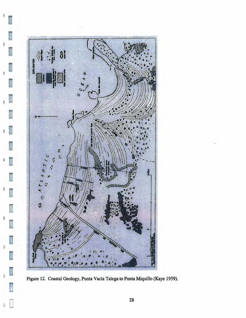
12. Coastal Geology, Punta Vacia Talega to Punta Miquillo 28
13. Detail, Geologic Map of Rio Grande 29
14. Aerial photograph of Punta Miquillo 30
15. Generalized eustatic sea level curve for last 40,000 years 52
16. Approximate coastline of Puerto Rico during the Pleistocene 53
17. Historic illustration of Caribbean aboriginal canoe 54
18. Plan of Puerto Rico, 1769 65
19. Plan of Puerto Rico, 1825 66
20. Plan of Puerto Rico, 1837 67
• 21. Plan of Rio Grande, 1840 68
~
C
• 22. Caravel. c.1S00 70
23. Galleon, c. 1580 71
24. Frigate, c. 1830 72
25. Schooner, c.1860 73
26. Mail Steamer, c.1890 74
• 27. Segment of 1681 derrotero 83
28. Detail of Punta Miquillo and Ensenada Comez6n 84
29. Paradisus Hotel 95
J 30. Ensenada Comez6n 95
31. Mud flats during low tide 96
32. End of Ensenada Comez6n 96
33. Entrance to Ensenada Comez6n 97
34. West coast of Punta Miquillo 97
• 35. Artificial wetland channel 98
36. End of wetland channel 98
37. Metal detection survey 99
• 38. Diving inspection 99
39. Coring 100
40. Coring tools 100
41. Diver with metal detector 101
42. Eolianite rock fragment 101
I 43. Modem fish bone 102 ~
c
44. Prehistoric ceramic shard 102
45. Prehistoric ceramic shards 103
• - -
List of Tables
1. Shipwrecks off the Northeast Coast of Puerto Rico 85
2. Shovel Tests, Coco Beach 104
3. Underwater Coring 105
• - -
[
\
o
Acknowledgements
The Submerged Cultural Resources Survey, Stage I, Coco Beach Resort, Punta Miquillo, Rio Grande, Puerto Rico, was made possible by the support of the; CMA Architects a& Engineers, particularly Engr. Jose Torres; Engr. Jose Aponte, Coco Beach Resort; assistant archaeologists Erik Rivera Marchand and Eminett Jimenez; the personnel of the Archivo General de Puerto Rico (AGPR), particularly archivist Juan Carlos Roman; the State Historic Preservation Office; the Consejo Arqueo16gico Subacuatico and the Consejo Arqueologico Te"estre, Institute of Puerto Rican Culture, and my wife Nanette for assistance in the office. To all, thank you for your support.
N
) ~
)
•
)
~
I
•
•
•
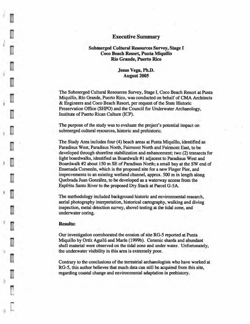
Executive Summary
Submerged Cultural Resources Survey, Stage I Coco Beach Resort, Punta Miquillo
Rio Grande, Puerto Rico
Jesus Vega, Ph.D. August 2005
The Submerged Cultural Resources Survey, Stage I, Coco Beach Resort at Punta Miquillo, RIo Grande, Puerto Rico, was conducted on behalf of CMA Architects & Engineers and Coco Beach Resort, per request of the State Historic Preservation Office (SHPO) and the Council for Underwater Archaeology, Institute of Puerto Rican Culture (lCP).
The purpose of the study was to evaluate the project's potential impact on submerged cultural resources, historic and prehistoric.
The Study Area includes four (4) beach areas at Punta Miquillo, identified as Paradisus West, Paradisus North, Fairmont North and Fairmont East, to be developed through shoreline stabilization and enhancement; two (2) transects for light boardwalks, identified as Boardwalk #1 adjacent to Paradisus West and Boardwalk #2 about ISO m SE of Paradisus North; a small bay at the SW end of Ensenada Comezon, which is the proposed site for a new Finger Pier, and improvements to an existing wetland channel, approx. SOO m in length along Quebrada Juan Gonzalez, to be developed as a waterway access from the EspIritu Santo River to the proposed Dry Stack at Parcel G-SA.
The methodology included background historic and environmental research, aerial photography interpretation, historical cartography, walking and diving inspection, metal detection survey, shovel testing at the tidal zone, and underwater coring.
Results:
Our investigation corroborated the erosion of site RG-S reported at Punta Miquillo by Ortiz Aguihl and Mann (1999b). Ceramic shards and abundant shell material were observed on the tidal zone and under water. Unfortunately, the underwater visibility in this area is extremely poor.
Contrary to the conclusions of the terrestrial archaeologists who have worked at RG-5, this author believes that much data can still be acquired from this site, regarding coastal change and environmental adaptation in prehistory.
,
t
[
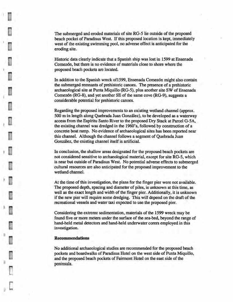
The submerged and eroded materials of site RG-5 lie outside of the proposed beach pocket of Paradisus West. If this proposed location is kept, immediately west of the existing swimming pool, no adverse effect is anticipated for the eroding site.
Historic data clearly indicate that a Spanish ship was lost in 1599 at Ensenada Comez6n, but there is no evidence of materials close to shore where the proposed beach pockets are located.
In addition to the Spanish wreck of1599, Ensenada Comezon might also contain the submerged remnants of prehistoric canoes. The presence of a prehistoric archaeological site at Punta Miquillo (RG-5), plus another site SW of Ensenada Comez6n (RG-8), and yet another SE of the same cove (RG-9), suggests a considerable potential for prehistoric canoes.
Regarding the proposed improvements to an existing wetland channel (approx. 500 m in length along Quebrada Juan Gonzalez), to be developed as a waterway access from the Espiritu Santo River to the proposed Dry Stack at Parcel G-5A, the existing channel was dredged in the 1960's, followed by construction of a concrete \>oat ramp. No evidence of archaeological sites has been reported near this channel. Although the channel follows a segment of Quebrada Juan Gonzalez, the existing channel itself is artificial.
In conclusion, the shallow areas designated for the proposed beach pockets are not considered sensitive to archaeological material, except for site RG-5, which is near but outside of Paradisus West. No potential adverse effects to submerged cultural resources are also anticipated for the proposed improvement to the wetland channel.
At the time of this investigation, the plans for the finger pier were not available. The proposed depth, spacing and diameter of piles, is unknown at this time, as well as the exact length and width of the finger pier. Additionally, it is unknown if the new pier will require some dredging. This will depend on the draft of the recreational vessels and water taxi expected to use the proposed pier.
Considering the extreme sedimentation, materials of the 1599 wreck may be found five or more meters under the surface of the sea-bed, beyond the range of hand-held metal detectors and hand-held underwater corers employed in this investigation.
Recommendations
No additional archaeological studies are recommended for the proposed beach pockets and boardwalks of Paradisus Hotel on the west side of Punta Miqulllo, and the proposed beach pockets of Fairmont Hotel on the east side of the peninsula.
. \
o
Regarding Paradisus West, the developers and engineers should be careful not to extend south of the proposed beach pocket as defined in Figures 3 and 4 of this report.
No additional archaeological studies are recommended for the proposed improvement to the wetland channel. No submerged archaeological sites are anticipated for this channel, created by modem dredging in order to facilitate the area's drainage. The proposed improvement is limited to a previously dredged channel.
Ensenada Comez6n is considered sensitive to submerged archaeological sites, primarily due to the loss of a Spanish nav(o in 1599.
For the finger pier at Punta Miquillo, marine archaeological monitoring is recommended. Of all the proposed developments, this is the only one with potential adverse effects to submerged cultural resources, including possible prehistoric canoes and, more importantly, the Spanish shipwreck of 1599.
Intrinsically, the discovery of a prehisto~c canoe would probably be more important than a shipwreck site, because no submerged prehistoric canoe has been discovered in Puerto Rico. The Spanish shipwreck is considered more important because it is a documented loss at Ensenada Comez6n, as opposed to an archaeological probability.
Ideally, the cove of Ensenada Comez6n should be surveyed in detail through a combined proton magnetometer and sonar survey. However, since no shipwreck materials were found within the Study Area, the remote sensing survey should be considered optional.
Beyond their historic and scientific importance, historic shipwrecks also have great recreational potential. For the visitors to Punta Miquillo, given the outstanding topside views and the unimpressive underwater sights provided by sea grass, exploring a 16th century Spanish shipwreck in shallow water would be a thrilling experience. Perhaps, such an experience would be particularly gratifying to visitors from Spain, and to anyone coming to Puerto Rico with the idea of undersea recreation. Although shipwreck archaeology can be complex, the developers of Paradisus and Fairmont hotels should not underestimate the attraction of a ship lost 405 years ago, in front of their properties .
• - -
•
1. Introduction
This report documents the methodology and results of the Submerged
Cultural Resources Survey, Stage I, Coco Beach Resort, Punta Miquillo,
Rio Grande, on the northeast coast of Puerto Rico (Figures 1 and 2).
The investigation reported herein was conducted on behalf of CMA
Architects & Engineers and Coco Beach Development Corp., in San Juan, per
request of the State Historic Preservation Office and the Council for
Underwater Archaeology, Institute of Puerto Rican Culture, San Juan, Puerto
Rico.
This report details the methodology and results of the background
literature search (Stage IA) and field investigation (Stage m), including, aerial
photo interpretation, walking and diving inspection, metal detection survey,
and underwater coring.
1
I
c
1.1 Study Area
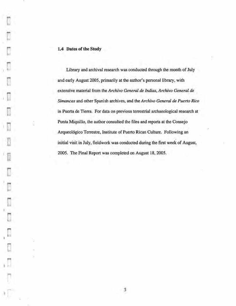
The location of the Study Area is presented in the NOAA Nautical Chart
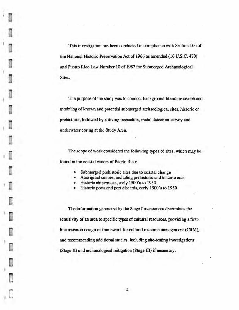
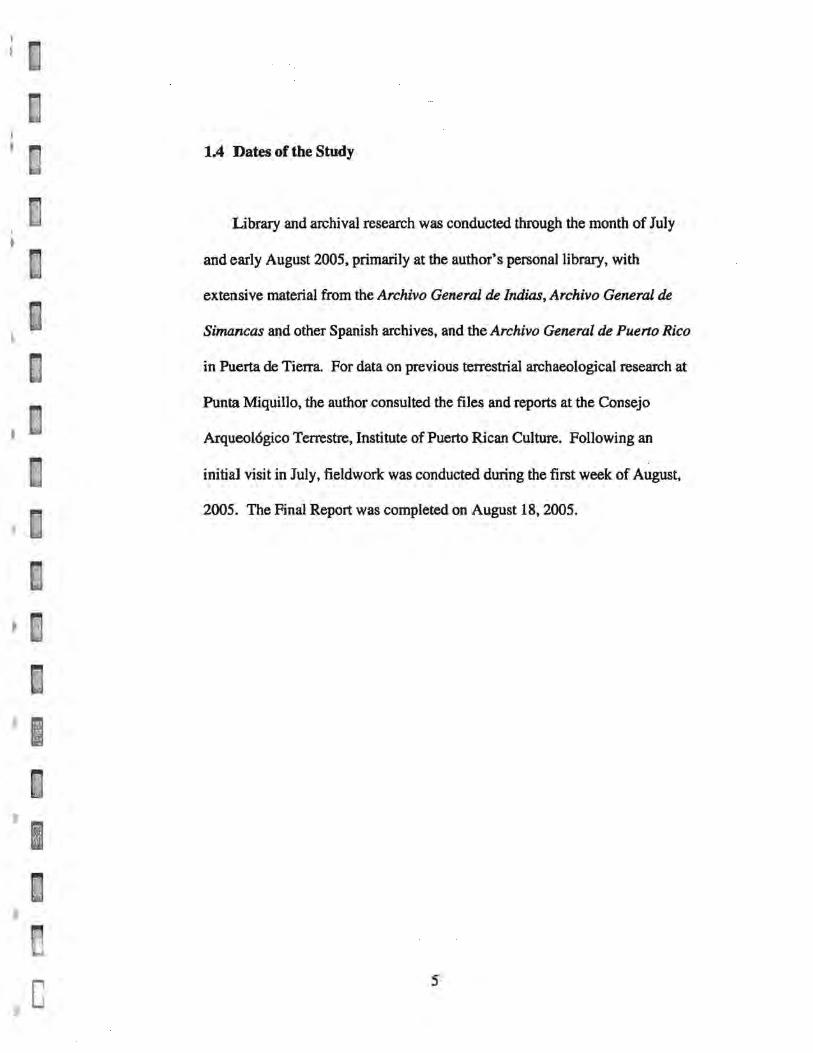
for Virgin Passage and Sonda de Vieques (Figure 1), and the USGS Rfo
Grande Topographic Quadrangle (Figure 2).
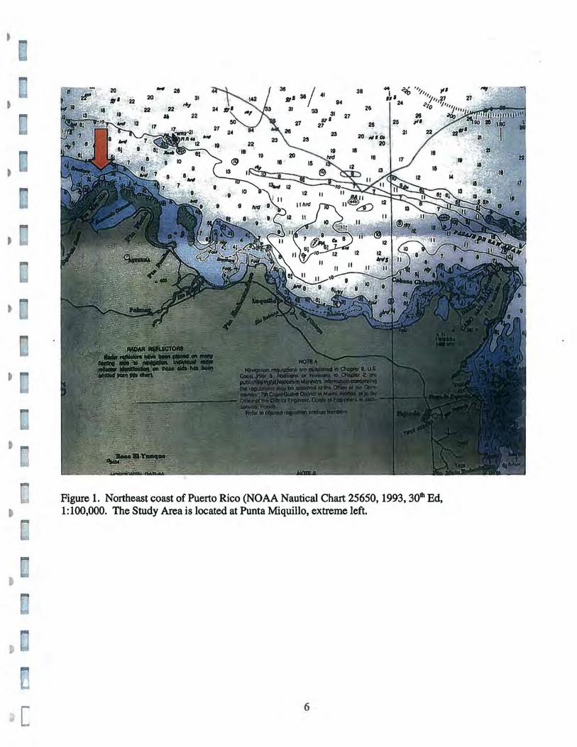
The Study Area includes four (4) beach areas at Punta Miquillo, identified
as Paradisus West, Paradisus North, Fainnont North and Fainnont East, to be
developed through shoreline stabilization and enhancement; two (2) transects
for light boardwalks, identified as Boardwalk #1 adjacent to Paradisus West
and Boardwalk #2 about 150 m SE of Paradis us North; a small bay at the SW
end of Ensenada Comez6n, which is the proposed site for a new Finger Pier,
and improvements to an existing wetland channel, approx. SOO m in length
along Quebrada Juan Gonzalez, to be developed as a waterway access from
the Espfritu Santo River to the proposed Dry Stack at Parcel G-SA (Figures 2
to 11).
The terrestrial portion of Coco Beach has been evaluated for cultural
resources since 1980, including the detection of a small prehistoric village at
Punta Miquillo (RG-5), and additional sites south and southeast of the
peninSUla (Daub6n Vidal 1990, 1992, 1996; Ortfz Aguilu y Marin 1999,2000;
Rodriguez L6pez 1980; Rodriguez Morales 198~, 1989).
2
o
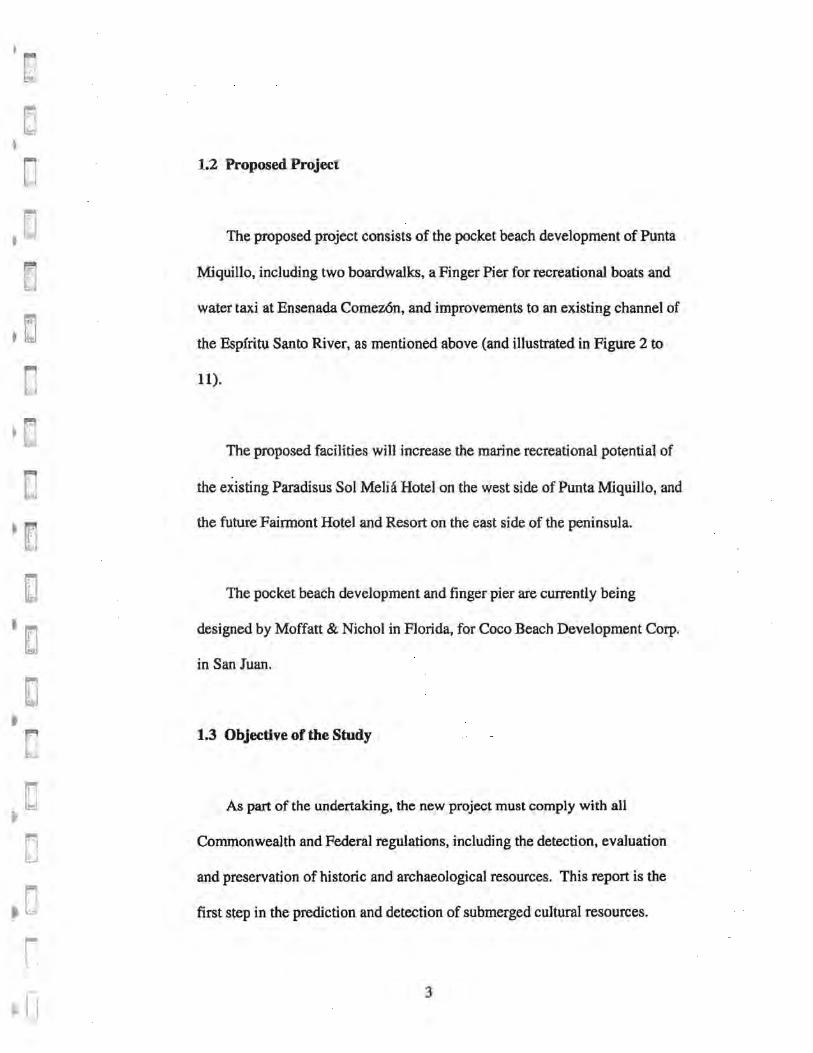
1.2 Proposed Project
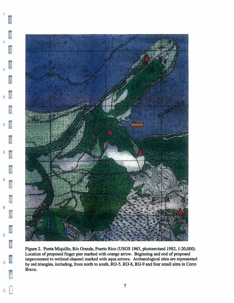
The proposed project consists of the pocket beach development of Punta
Miquillo, including two boardwalks, a Finger Pier for recreational boats and
water taxi at Ensenada Comez6n, and improvements to an existing channel of
the Espfritu Santo River, as mentioned above (and illustrated in Figure 2 to
11).
The proposed facilities will increase the marine recreational potential of
the existing Paradisus Sol Melia Hotel on the west side of Punta Miquillo, and
the future Fainnont Hotel and Resort on the east side of the peninsula.
The pocket beach development and finger pier are currently being
designed by Moffatt & Nichol in Florida, for Coco Beach Development Corp.
in San Juan.
1.3 Objective of the Study
As part of the undertaking, the new project must comply with all
Commonwealth and Federal regulations, including the detection, evaluation
and preservation of historic and archaeological resources. This report is the
first step in the prediction and detection of submerged cultural resources.
3
)
I
c
This investigation has been conducted in compliance with Section 106 of
the National Historic Preservation Act of 1966 as amended (16 U.S.C. 470)
and Puerto Rico Law Number 10 of 1987 for Submerged Archaeological
Sites.
The purpose of the study was to conduct background literature search and
modeling of known and potential submerged archaeological sites, historic or
prehistoric, followed by a diving inspection, metal detection survey and
underwater coring at the Study Area.
The scope of work considered the following types of sites, which may be
found in the coastal waters of Puerto Rico:
• Submerged prehistoric sites due to coastal change • Aboriginal canoes, including prehistoric and historic eras • Historic shipwrecks, early 1500's to 1950 • Historic ports and port discards, early 1500's to 1950
The information generated by the Stage I assessment dctcnnines the
sensitivity of an area to specific types of cultural resources, providing a first-
line research design or framework for cultural resource management (CRM),
and recommending additional studies, including site-testing investigations
(Stage m and archaeological mitigation (Stage ill) if necessary.
4
c
1.4 Dates of the Study
Library and archival research was conducted through the month of July
and early August 2005, primarily at the author's personal library, with
extensive material from the Archivo General de Indias, Archivo General de
Simancas and other Spanish archives, and the Archivo General de Puerto Rico
in Puerta de Tierra. For data on previous terrestrial archaeological research at
Punta Miquillo, the author consulted the files and reports at the Consejo
Arqueo16gico Terrestre, Institute of Puerto Rican Culture. Following an
initial visit in July, fieldwork was conducted during the first week of August,
2005. The Final Report was completed on August 18,2005.
5
- 28 20
22 22
"
31 "."
22
36 J7S 38/ 41 94
31 33 31
27 II' 27
27
38
18
26
25
20 l1li'''' 20
18
26
21
Figure 1. Northeast coast of Puerto Rico (NOAA Nautical Chart 25650, 1993, 30th Ed, 1:100,000. The Study Area is located at Punta Miquillo, extreme left.
6
o
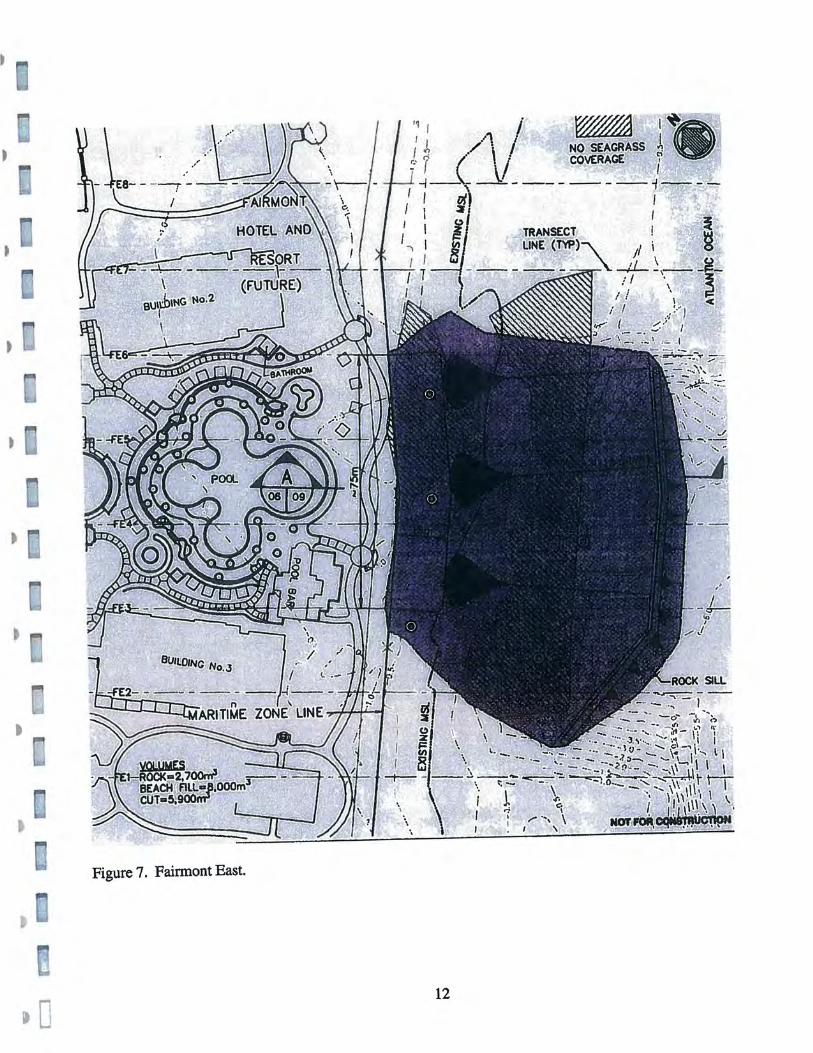
Figure 2. Punta Miquillo, Rio Grande, Puerto Rico (USGS 1963, photorevised 1982,1:20,000). Location of proposed finger pier marked with orange arrow. Beginning and end of proposed improvement to wetland channel marked with aqua arrows. Archaeological sites are represented by red triangles, including, from north to south, RG-5, RG-8, RG-9 and four small sites in Cerro Bravo.
7
•
•
~
a
a
t
0 :fi ~f
~ ;r'
~~j
~ ..
"J
~
D "otl
0 r l.:
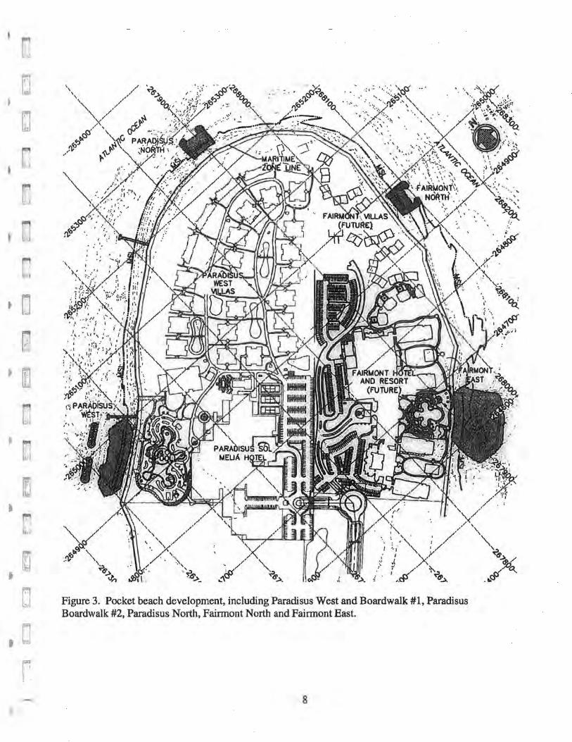
Figure 3. Pocket beach development, including Paradisus West and Boardwalk #1, Paradisus Boardwalk #2, Paradisus North, Fairmont North and Fairmont East.
8
o
, I! :!, '" •• of· 'I J ~ Ii: , _ :j .~ ... ~.~ .... . '1 ,
! '" 1" I' r - . -, - --I-- - -- - -~ll""--~!:,.. ,,,: ~~~~'.f< ; I I " • ,,' r,\ , I I I I ;
I I
I '
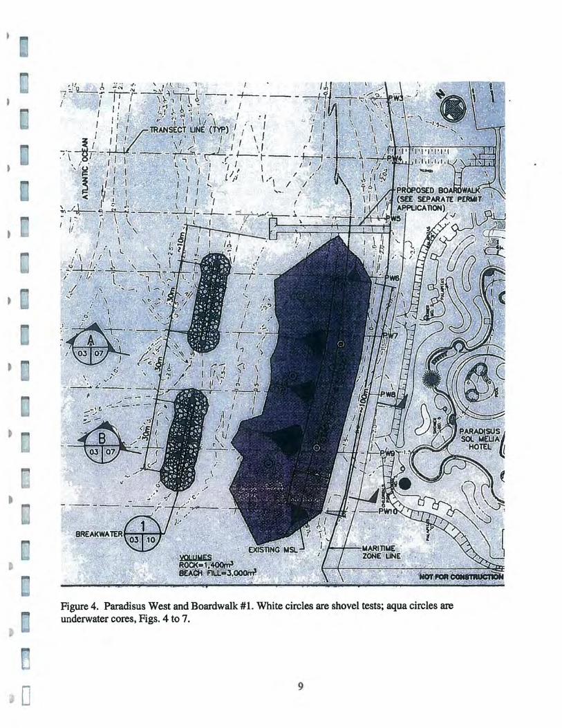
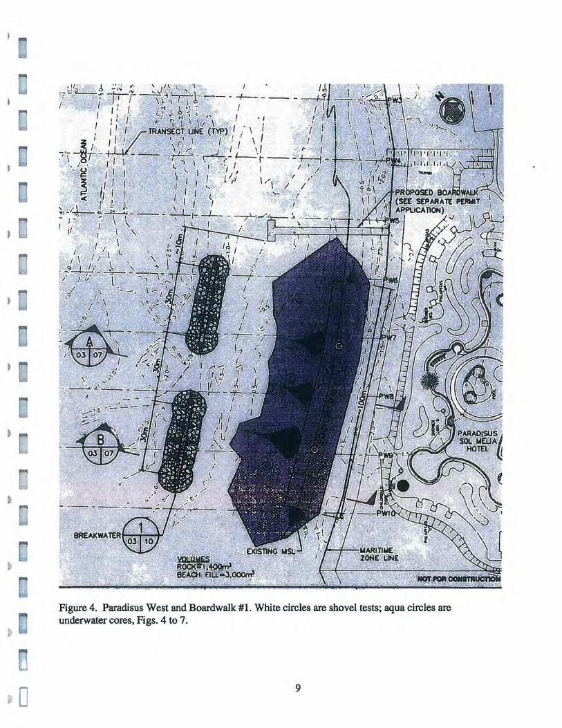
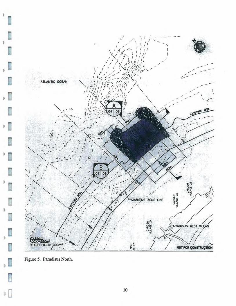
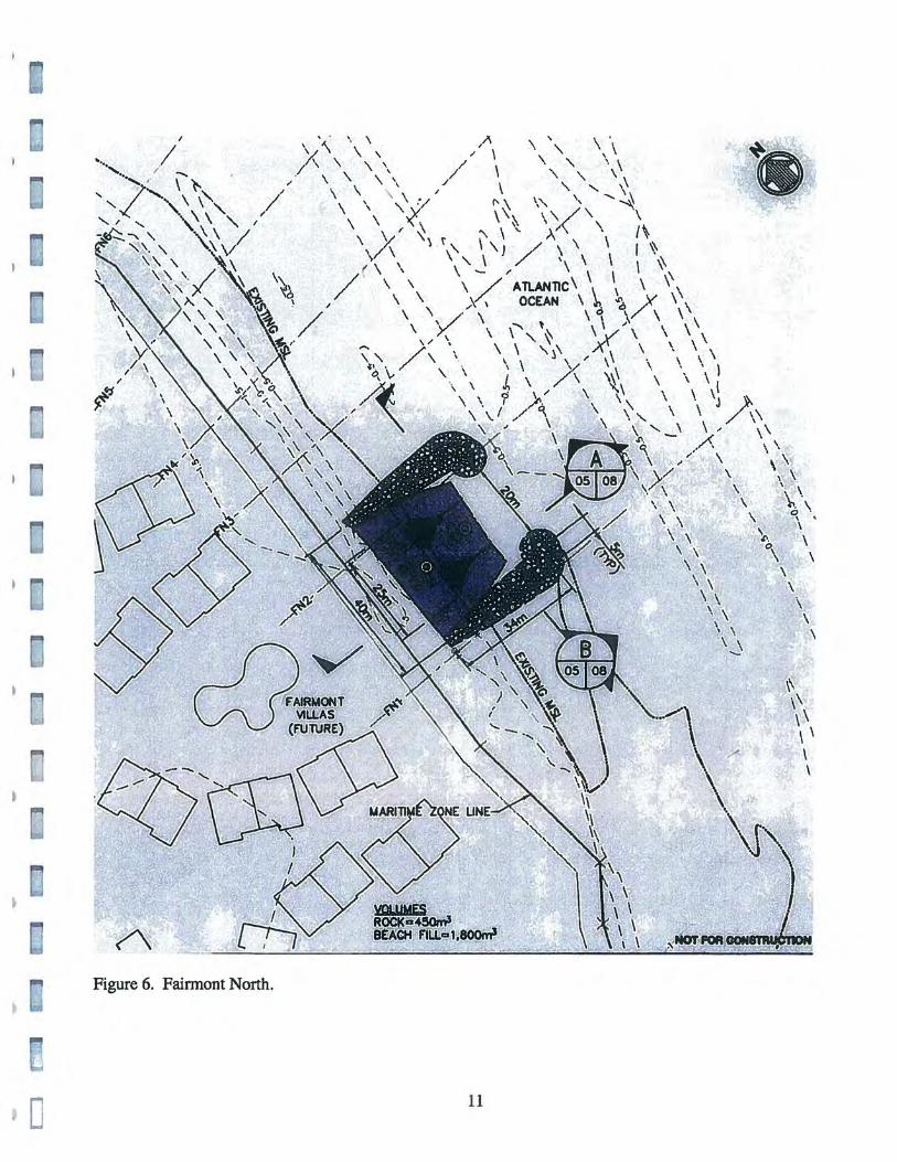
Figure 4. Paradisus West and Boardwalk #1. White circles are shovel tests; aqua circles are underwater cores, Figs. 4 to 7.
9
•
•
o
, "
f i~
. '. " . .. ,,"/"'
'~ .. ~ / ' .... , I
...
t'.
) I~ I !
'/
.I ,.
'\
I
!
: :
(
.," "\ ~) I j l ., ' ___ I .... ..
/ ." ,:' :. .'
t' ,I • I.{,/ j····,1 r! " '\ r.) '.
~/""'\~\ 'i' /
' .., '. I I , . ' , 1 , I!.'
• / I " d\ I. I \ , I : "'. -, \ ,r.. / ( , , . x. Il' \ '..::~ ,. ,.'
I I , 1'\ ~ ; ,' .... / ~"~~ .r ..... t J . I ') '\, j / .;. :vl,~:< ... / \., /'
. / I I.' ...... '(. .• r, .. ,\.\ , , . .' ." .. ' ·4 ""ie. / ..
ATLANTIC OCEAN I. J/r :.,::.:-: __ ., ////'. ~ ')
'", I ~ , , I f ('1' " / /'. /; / ~\ , •• /1 Q ... ,./( I / .::'If"., I I I .. ' " , , . , '. . I : '\
" 'to (toil ." ,~\,. J. I /
, .IN',,,'/' o ..... ··jl!,.I; " _ .'\. J ( " ". ,
/ I .~~~': . I~'/.;.~'" \ i f I J / .:,~ / / '"}' I,· . ~ . ••• "I
I f 1'-~ I !. ':~. :> :+--"':--1 I / ...; .. \ '~: .. :~- ..
: .... '··~· ~ !.r '. ~ .. .. _ ~ -, .-........ ./ ~" ..... . ..... ... .
/ --.... , -..... ,. . .. . , .. ~" . "~
/ /, / -,-.. " <', c,i' '"
.'.J rio . ,;' / .......... '.~ -.-" I'; ,--/ I / ':. 1'. I ' ~' , '7 - ... '
••. :..~,J ! 1/ /( / " "-._... ,f ~./ , ., \ "
r-
~~ , ...
,
'" .. "
.' / ! J ~'i I / / I
,., ~~? i .! .. - ~ , .- i "
.. •
,.. >'>...-'. " , ,,1 "I ,.'
~.
" ,',. .... . . , , .... / ..- -
I ,
" ' f /
'fo......." : r'j. , ,
'/ I . .'
i
/
. , ,
,
.. ' ,
,
:-' i. ~. c.
'I;r' I')
ZN W ew
'.J,-~.,.
... %('01
'" fit~ ~j
:s
'f
.~
.'
.
, ....
. ....
,
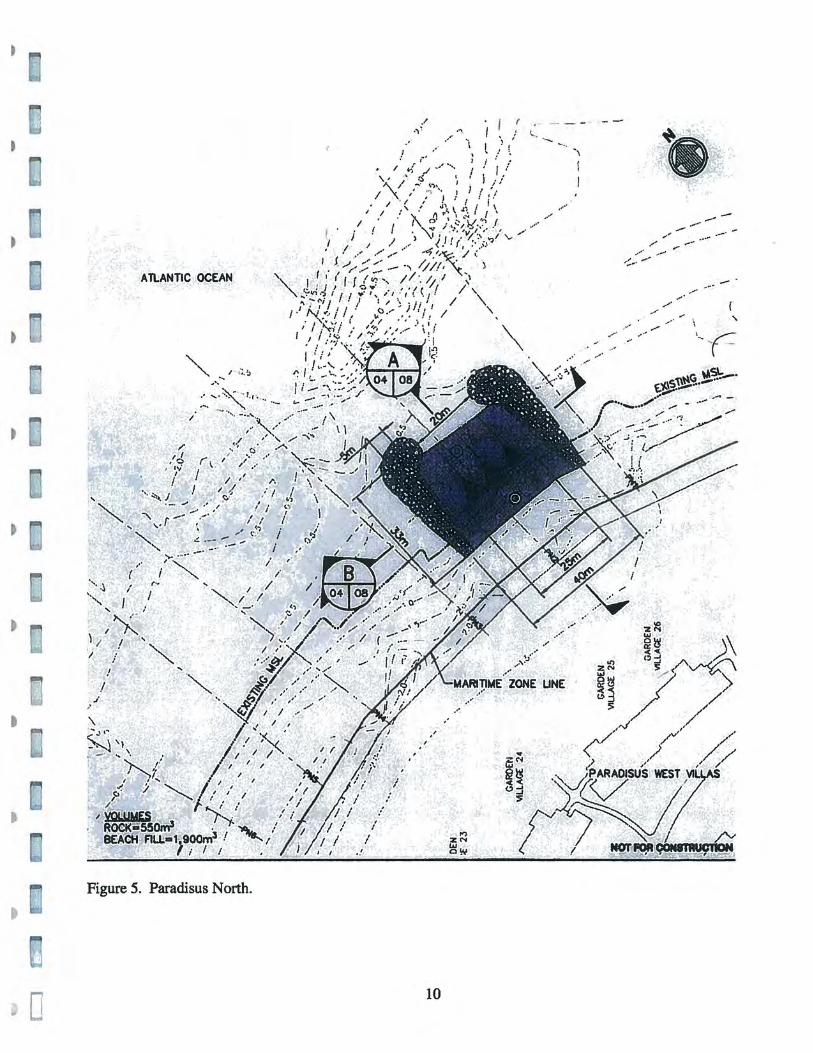
Figure 5. Paradisus North.
10
. .....
zll3
I~ :>
..... ,.-' , .. ' ,. ........
. :'
.. - .-' .. ~.
, '''' ~C= C -
.' .
't1 .... r., '
•
•
c
, ,I
I
, ,. .. \ )I. \ '" \" \/ '\ \, ,,' , \" \. \
//\ \ "'- // \ "\ \ \ " \" \ \ / \ "" \
\ \ \ • I \" " ....... ~ ,,/ \ \ "..;/ \ ~\ \ " /" \ \ \ ,."1(\ "\ \'~ x'(.. \ 1\
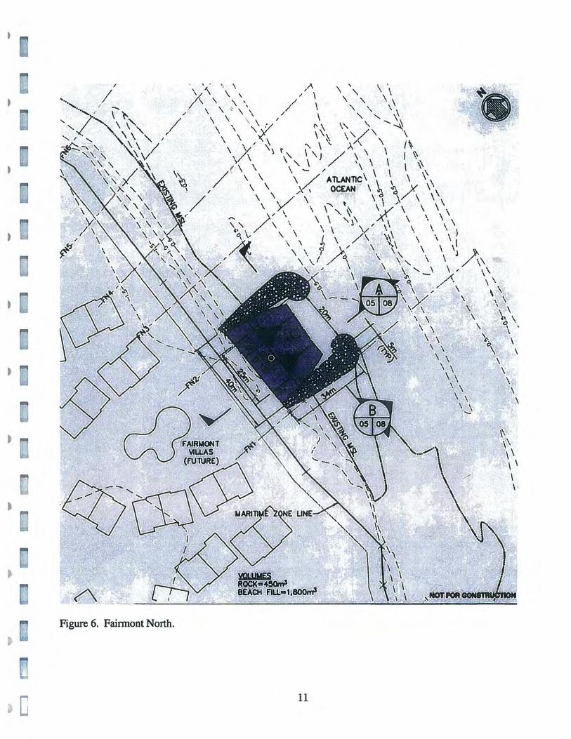
Figure 6, Fainnont North,
\ y "\ \'" \ \) / \ \ \ I ~ \/\ \ "\ / '\ \ \ \ ~
/( \ \\ \/ ....." ATLANTlC\ \ \ \ '\
\ \ .... \:., OCEAN \ ~ ~\A\ \\ I \ \. /' \ \ \ ,,\ \
\ >\ \ \""' '- \ \ IV \ \ \ \ )" \ \, \ \ X'. \ ' \
'\ \ / \ \. \ ~ \/ I ,\ \ \ \, I ~;; \, \ \ ./, \ /\ \~, \ \ \ I
~: \ \ ci \" \ \' \ \ \J )-,. ,'" \ \ / /"'q \ .~, \ \ / \\
\ '- "\ \ \ ..... _\ \... \ \ \ ~. A \\ '\ ,,/ \ , \
.. \,/ \ \ \ v .... \ 'X \ \ '\\ -\ ~\
11
\ \ \ \ '
\ " \.. \ , 0\ ~ \: " \
\ " \ \ \. \ \ \ \ \ \ ~ \ \ \ ~\ \
'-
\\ ~\ \\
\ ' \ \ I
•
Figure 7. Fainnont East.
12
•
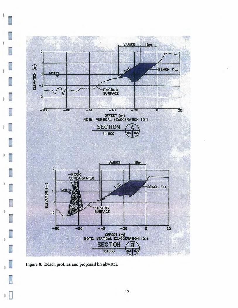
Figure 8. Beach profiles and proposed breakwater.
o 13
,~
• ·~.I
~" (.
t ..
t If'l ~
~ t
~
to r l .;
r~' r I LJ
1.2 Proposed Project
The proposed project consists of the pocket beach development of Punta
Miquillo, including two boardwalks, a Finger Pier for recreational boats and
water taxi at Ensenada Comez6n, and improvements to an existing channel of
the Espfritu Santo River, as mentioned above (and illustrated in Figure 2 to
11).
The proposed facilities will increase the marine recreational potential of
the existing Paradisus Sol Melia Hotel on the west side of Punta MiquiIIo, and
the future Fairmont Hotel and Resort on the east side of the peninsula.
The pocket beach development and finger pier are currently being
designed by Moffatt & Nichol in Florida, for Coco Beach Development Corp.
in San Juan.
1.3 Objective of the Study
As part of the undertaking, the new project must comply with all
Commonwealth and Federal regulations, including the detection, evaluation
and preservation of historic and archaeological resources. This report is the
first step in the prediction and detection of submerged cultural resources.
3
This investigation has been conducted in compliance with Section 106 of
the National Historic Preservation Act of 1966 as amended (16 U.S.C. 470)
, and Puerto Rico Law Number 10 of 1987 for Submerged Archaeological
Sites. :.J
~ t.
The purpose of the study was to conduct background literature search and
~ modeling of known and potential submerged archaeological sites, historic or
prehistoric, followed by a diving inspection, metal detection survey and , . .',
underwater coring at the Study Area.
~ • ~
The scope of work considered the following types of sites, which may be
found in the coastal waters of Puerto Rico:
~ ~ • Submerged prehistoric sites due to coastal change
~ '.c.' ~
"
• Aboriginal canoes, including prehistoric and historic eras • Historic shipwrecks, early 1500's to 1950 • Historic ports and port discards, early 1500's to 1950
D t The information generated by the Stage I assessment determines the
0 sensitivity of an area to specific types of cultural resources, providing a first-
0 line research design or framework for cultural resource management (CRM),
and recommending additional studies, including site-testing investigations
D (Stage II) and archaeological mitigation (Stage ill) if necessary.
r t LJ
r I ,
..... 4
j
o
c
~ I , I . I. ,
1.4 Dates of the Study
Library and archival research was conducted through the month of July
and early August 2005, primarily at the author's personal library, with
extensive material from the Archivo General de Indias, Archivo General de
Simancas and other Spanish archives, and the Archivo General de Puerto Rico
in Puerta de Tierra. For data on previous terrestrial archaeological research at
Punta Miquillo, the author consulted the files and reports at the Consejo
Arqueol6gico Terrestre, Institute of Puerto Rican Culture. Following an
initial visit in July, fieldwork was conducted during the first week of August,
2005. The Final Report was completed on August 18,2005.
5
•
t
•
[
- 28 38., 38/ 41 38
'22 20 31
"I 9. 22 31 33 26
22 31 27 27 U '
26 27
23
Figure 1. Northeast coast of Puerto Rico (NOAA Nautical Chart 25650,1993, 301h Ed, 1:100,000. The Study Area is located at Punta Miquillo, extreme left .
6
•
o
Figure 2. Punta Miquillo, Rfo Grande, Puerto Rico (USGS 1963, photorevised 1982, 1:20,000). Location of proposed finger pier marked with orange arrow. Beginning and end of proposed improvement to wetland channel marked with aqua arrows. Archaeological sites are represented by red triangles, including, from north to south, RG-5, RG-8, RG-9 and four small sites in Cerro Bravo.
7
0 • ~,
'j
~
• "', ~.:.
"
• ~ ..
.. ~
, ,. "
:
or :
Figure 3. Pocket beach development, including Paradisus West and Boardwalk #1, Paradisus Boardwalk #2, Paradisus North, Fairmont North and Fairmont East.
8
" \.
'"", ~ is'~/ /::o~
, .. ~
•
•
o
• I
I '\ I I / \ I I \ I
~;::;,-~~.--~,·-l----·r - -I I I I J
;1 .
£ \ oj \ ,. ' / I
1 I \ / /
, :.. .
Figure 4. Paradisus West and Boardwalk #1. White circles are shovel tests; aqua circles are underwater cores, Figs. 4 to 7.
9
,
•
»
•
o
.," ..... ," I .. . ,
.' " , "\ I ............. .
f ,.' / :, " *' / ~ ,./ .... ' ..... / I : '" ", ~ , ',: ,,/ -' '"" j I'
/ " " ~ "J ] } I ,,/ , ,, ' / " J" f • '\ ••.•.
~ I ./ ' . ft~:" \ "::. I f \ .... I ' .,.. 0' .' ,,', I·' f ' .
I I I f\ .... ..,. I ,,"I ~/"', . ,.'
J . . ,\1 . '. 'V • , ,/
I I I ; I I • '1..:' .. "'/ '\-, I / .' ..... "( .. ( t • ,,'..'
. ..- ..... '~ -4/,,1 ... IJ,~"~' / . . ; __ ,.,/ ~_ ._ . .., I//!, )
'"" I ~ I I I f I,,?" . ;;', I; I ~\ " S·";·~ l, I ~ '1, ,', !,. ( <. / / '\
.. ';- "i I . l I"',, I . , , I I J "!...", / /: ",0,,, ", ~ f! / / '\
/ I .~i / t. I~'/ ,; ~ ." ~ I f I / t~ : / ',. I, " • ~
" . l"/
ATLANTIC OCEAN
", 1//>' " 1 G." "I .... ~.' .... ~ !... - , .... -,',
,,". It' ~ ... \ '::, :~ .... " ..... ;~ "" . , .... _ c,..'-' -, .-........ j
...... "'" .... - .' / ... ... ,. "''',. ".,
,,..)< /-"; ~ ", A
" ; . () .r , , __
,'Q r I Ii'· ~ .. ,,' ~ ... -, ~\; / \ . '" '- -/ /" /,,1\,
" '" ':'~" J ,-' ,"/ :' I ,.t -, \ ""', "- '- ...,. / J '" '" -, r .".- _., ,-' ' ",' I "
",. t J , , ,,' {,;i i
'""" .! .. -'"' --:-_' .. , i " "" .-.-_.
'''',,~ /
"", I
) I~
I ! ... I i
!
.I .I
" \
; :', f', /
t '., / / ,/ / ._.
"
"" " .t, .. .~
."'-...
Figure 5. Paradisus North.
"
~.
,.'
.. ' ,
, ,
,
/ I
pi) ZN W , elY
10
-' .... -' .-'
,,,..' '\
" ......
o
, . \ \ /'" \', \ \ 'x'\ \, ,I' \" \ \
./ \ \ \ \ // \ ',,, \\ ,I \ \ \ \ ./ \ "" \
\ '- \:/1 1'\ ,,, \, '~ //' \ \ 'yl \ '\~ \ \ / \ \
\ \ ,."It\\ " \ \. )../\ \ 1\
Figure 6. Fainnont North.
\ 'y '\ t" \ \ J / \ \ \ I ~ \/\ \ , \ '\ \ \ \ \\
\ '\ \/ --,I ATLANllC\ \ \ \ '\ \ \ X \ OCEAN \ ~ ~ ~ \\
\ \ /\ \ I \ \ \
\ Y( \ \""'" \ \ lv"" \ \ \ , ,I \ \ \ \ \ X'. \ ' \
\,,, / \ \. \ j, / \\ \ \' I 'b,\. \\ 1\ /\ ~ \ \\1
~ ,,\ . \,1 \ ,\ \ \ \J ): " \ \, 7 /1I~ \ ~ \ \ / \ \
' \ \ ,I \ ~ <',_\ \" \\ \ "'~.A \\
\ .. / \ , \ .\/ \ , \ /~ \ . , \ \, \ \ . \ \ \ ~ \.
\ \ \ \ \
11
\ \ '.r.. \ '\ \ '\ \
\ \ \ \ \ \ \ \ \ \\ \
\ ~ \ \ \ \ '-
\\ \\ \' \ \
\ \
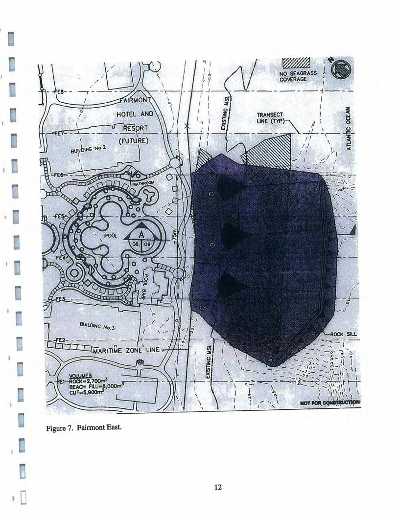
Figure 7. Fairmont East.
12
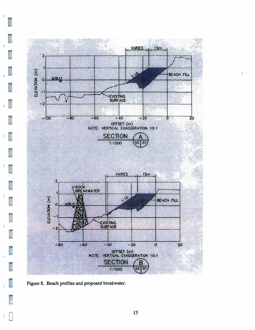
Figure 8. Beach profiles and proposed breakwater.
o 13
From the perspective of historical archaeology, the insular shelf is where
most historic shipwrecks were lost, primarily due to groundings, storms and
hurricanes, collision, battles. and fire. Although many important shipwreck
sites lie in deep waters, the insular and continental shelves are likely to remain
the primary areas of undersea archaeological research during the 21 sl century.
2.3 Coastal Geology of Rio Grande
The coast of Rio Grande is characterized by wetlands and lowlands with
Holocene sediments, inshore reefs, and medium-sized rivers. The hidrology is
controlled by the Herrera River to the west (on the border with LOlza), the
Espfritu Santo River, the Cano de Rodrfguez which runs across Cienaga La
Picua, and the Mameyes River to the east (on the border with Luqillo).
The Rfo Grande, or Grande River, namesake of the town and municipality,
is a tributary of the Espfritu Santo River, which meanders past the town of Rfo
Grande and connects to the main ri ver about 4 km south from the coast.
The names of these ri vers have changed through the centuries. The
• EspIritu Santo River was also known as the RIO Grande; Rodriguez Creek was
0 also known as Cano de Las Perchas and the Miquillo or Uquillo River, and the
Mameyes River was as also known as Rfo de la Sabana and Rfo Luquillo.
• :.~J n ~: I
r0- 25 t J
l ,
· ~ lfiI
•
•
o If;! lW
Cl
.D ~ I ' U
r I I
In previous centuries, the Rodriguez Creek was an active stream,
connected to the mouth of the Mameyes River to the east. The natural closing
of this river produced the large swamps (Qs) of Cienaga La Picua, which runs
along most of the Rio Grande coast, often separated from the sea by narrow
beach deposits (Qb).
The swamp deposits are characterized by black and dark-gray silt and
clay, with a high content of organic material, up to 5 m thick. The beach
deposits are mostly yellowish-gray to light-gray beach and eolian sand
composed of quartz grains with abundant shell and coral fragments. Interior
deposits also contain volcanic-rock grains and decomposing plant material
(Pease, Jr. and Briggs 1972).
Between the town of RIO Grande and the coast, the EspIritu Santo River
cuts through a large alluvial plain (Qa), mostly of brownish -gray and very
dark gray deposits of silt, clay and sand. Coarse gravel is usually present near
the river.
The adjacent coastlines of Loiza and RIO Grande were studied by Kaye
(1959:114-115), noting that this area has the deepest and most extensive fossil
beach ridges in Puerto Rico. The fossil beaches or relict shorelines are
evidence or coastal changes associated with sedimentation of the Loiza and
EspIritu Santo River. Two decades later, the coastal geology of these
26
municipalities was also studied by Monroe (1977) and Pease, Jr. and Briggs
(1972).
For dating the fossil ridges, Kaye used the 161h-century town of Loiza
Aldea, and a prehistoric site simply described as "the Indian site" (Kaye
1959:115). Although Kaye must be credited with the first use of historic maps
and archaeological data in the study of shoreline changes in Puerto Rico, his
use of the archaeological data is rudimentary.
Kaye indicates that the Indian site "belongs to the preceramic culture of
Puerto Rico." But the site located in his map corresponds to the large
ceramic site of Hacienda Grande (Rouse and Alegria 1990). Apparently,
Kaye misunderstood his oral communication with archaeologist Ricardo
Alegria, who also conducted important research on the nearby preceramic site
of Maria de la Cruz. Unlike the open site of Hacienda Grande, Maria de la
Cruz is located in a cave and therefore its use as coastal marker cannot be
applied directly.
While Kaye used archaeological data for his coastal geomorphology
studies, the author has reversed the equation, using geomorphological data in
order to predict the location and preservation potential of submerged cultural
resources, as discussed in section 3 of this report.
27
•
Figure 12. Coastal Geology, Punta Vacfa Talega to Punta Miquillo (Kaye 1959).
o 28
)
•
•
•
•
o
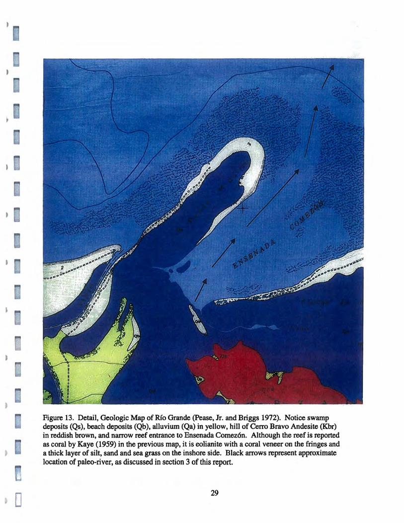
Figure 13. Detail, Geologic Map of Rio Grande (Pease, Jr. and Briggs 1972). Notice swamp deposits (Qs), beach deposits (Qb), alluvium (Qa) in yellow, hill of Cerro Bravo Andesite (Kbr) in reddish brown, and narrow reef entrance to Ensenada Comez6n. Although the reef is reported as coral by Kaye (1959) in the previous map, it is eolianite with a coral veneer on the fringes and a thick layer of silt, sand and sea grass on the inshore side. Black arrows represent approximate location of paleo-river, as discussed in section 3 of this report.
29
•
•
•
•
o
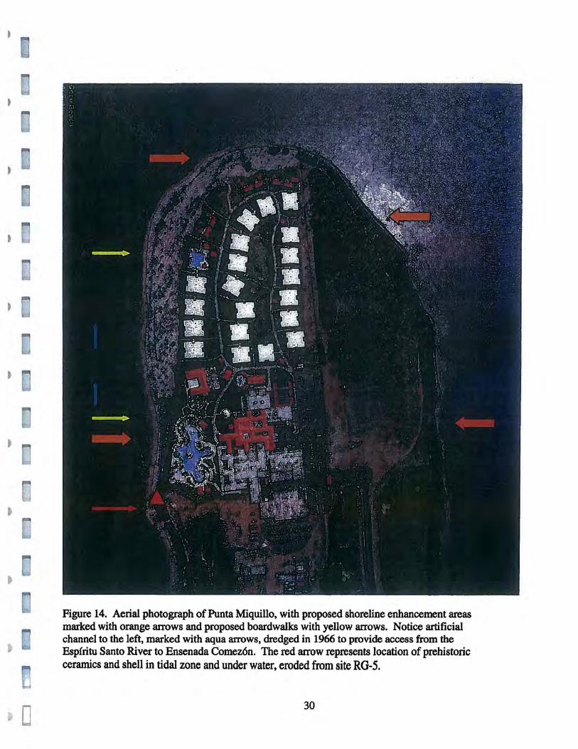
Figure 14. Aerial photograph of Punta Miquillo, with proposed shoreline enhancement areas marked with orange arrows and proposed boardwalks with yellow arrows. Notice artificial channel to the left, marked with aqua arrows, dredged in 1966 to provide access from the EspIritu Santo River to Ensenada Comez6n. The red arrow represents location of prehistoric ceramics and shell in tidal zone and under water, eroded from site RG-S.
30
[
3. Terrestrial and Submerged Prehistoric Sites
This section addresses the probability of prehistoric sites within or
adjacent to the Study Area. Caribbean prehistoric sites may include shell
middens, lithic quarries and workshops, human burials, post molds of thatched
houses, hearths, petroglyphs, ceremonial ball courts, canoes, etc.
Caribbean prehistory is often divided into preceramic and ceramic
cultures. Ceramic or pottery-making societies inhabited most of the islands by
the late 15th century, including the Taino chiefdoms or ranked societies of
Puerto Rico, considered with the chiefdoms of Hispaniola as the most
advanced aboriginal societies of the Caribbean.
Although some preceramic or non-pottery making societies were also
encountered by Spanish explorers and conquistadors, preceramic groups
generally occupied the islands thousands of years before the ceramic societies.
31
Known archaeological evidence indicates that the Greater Antilles were
occupied by preceramic hunter-gatherers at least 6,000 years ago, and by
ceramic or pottery-making horticulturalists about 2,500 years ago (Rouse
1992:51; Wilson 1997:4).
Environmental reconstruction of Pleistocene and Holocene sea levels
indicate the flooding of Caribbean insular shelves, almost certainly flooding
the earliest prehistoric sites in the region. Thus, the 6,000 yrs BP approximate
entry date of humans in the Caribbean is probably in error. The oldest
prehistoric sites are under the sea and they have yet to be found and dated.
3.1 Changing Levels of Land and Sea
Marine transgressions, the technical tenn for the flooding of coastal areas
by the sea, may occur due to a variety of local, regional, or global processes.
Land may be eroded or subside due to tectonic movement, isostatic depression
or sediment compaction. In higher latitudes, postglacial rebound may
gradually lift the coast.
Sea level may rise due to changes in the volume of ocean water or ocean
~ t
ridges (Donovan and Jones 1979). Following current theory, the major agent
of coastal change has been a global or eustatic sea level rise due to the melting
~ , ! k· j
,.... 32
L~
)
r t
r
of land-blocked ice, resulting from cyclical variations in the earth's orbit
(Hays et al. 1976:1121).
According to the glacio-eustatic model, low sea levels are associated with
land ice advances called stadials, while high sea levels are associated with the
retreat of land ice sheets called interstadials. The more ice on land, the lower
the sea level.
Numerous ice ages have occurred as far back as 93 million years ago, but
our concern is with the last ice age so far. Beginning about 80,000 yrs BP
(before the present), the more recent ice age is defined as the Wisconsin
glaciation in North America, and the Wtinn glaciation in Europe. This glacial
episode played a central role in the migration of our species, Homo sapiens
sapiens, to the principal archipelagoes of the world, including the Caribbean,
by reducing the distances between continental masses and offshore islands
world-wide.
There is general consensus that the sea was near its present level by about
35,000 yrs BP. Then the sea level began to drop as the Laurentide and other
Pelistocene ice sheets expanded over the Northern Hemisphere.
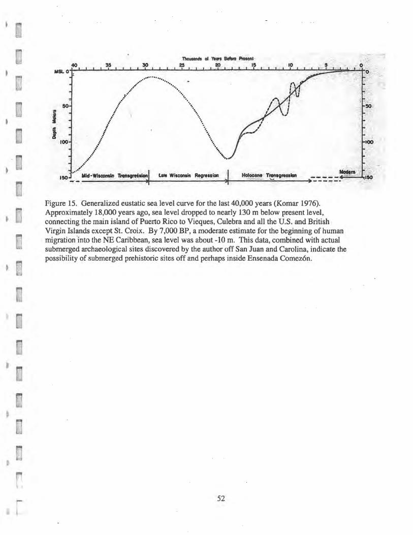
By 20,000 to 15,000 yrs BP, sea level reached its lowest point in the
Wisconsin glaciation. Estimates for this lowest sea level stand include minus
33
r [
60 m (Blackwelder et al. 1979), minus 85-90 m (Momer 1971), and minus
130 m (Milliman and Emery 1968).
Around 17,000 to 15,000 yrs BP, the Holocene marine transgression
began (Figure 8). During the most rapid stage of deglaciation, beginning
about 10,000 yrs BP, sea level probably rose at a rate of lOmm per year. By
7,000 yrs BP, sea level may have been some 10 m (32 ft.) below present level
(Shepard 1963). Much of the Caribbean Archipelago had been reached by
preceramic navigators by that time.
From 7,000 yrs BP onwards, the sea continued rising at a much slower
pace. At this stage, there are significant disagreements among researchers.
Van Andel and Laborel (1964), Fairbridge (1961) and others have proposed
sea level oscillations with higher-than-present sea levels in the late Holocene,
while Curray (1961), Scholl and Stuiver (1969), Shepard (1963) and others
have reported evidence of a smooth sea level curve approaching the present
level by about 4,000 to 2,000 B.P. Indirect corroboration from oxygen
isotopic analysis of glacial history supports slightly higher, late Holocene sea
levels than at present, but the problem remains an open question.
The rising seas were marked by interruptions or stillstands. These periods
of stationary sea levels allowed the development of marine terraces, which
may be observed under water. Prominent submarine terraces are found in the
34
· . Caribbean, the Gulf of Mexico, and the Pacific Ocean at the average depths of
15 m (49 ft.) and 40-45 m ( 130-165 ft.). The depth of marine terraces may
vary due to local tectonism, so that Pleistocene terraces may be found in
shallower water, and even above present sea level. ,
Stillstands also allowed the formation of sea caves, beaches, and
associated geomorphological features. From an archaeological perspective,
stationary sea levels also made possible the formation of permanent, or semi-
permanent, stratified coastal sites (Vega 1990, 1995).
Since the early 1930's, archaeologists speculated that prehistoric peoples
lived on portions of the now submerged, continental and insular shelves.
However, most researchers assumed that such sites would have been
destroyed by the rising seas of the Holocene transgression. Today, the
archaeological community has finally begun to realize that the traditional
"sand castle hypothesis" is false (Vega 1990). During the last three decades,
diving researchers have proven that submerged land sites of virtually any age
may survive inundation in both fresh and salt-water environments, and be
systematically studied under water.
Submerged land sites of prehistoric, classical or historic cultures have
already been found world-wide, including Florida, California, Maine, Canada,
Jamiaca, Puerto Rico, Cuba, Virgin Gorda, Nevis, St. Eustatius, Denmark"
35
Russia, Yugoslavia, Sweeden, France, England, Spain, Portugal, Gibraltar,
Italy, Greece, Turkey, Israel, Lebanon, Tasmania, The Philippines, etc.
(Masters and Flemming 1983; Muckelroy 1980, etc.).
Searching for submerged prehistoric sites was first proposed in the United
States by Goggin (1960), with early discussions by Solecki (1961), Shepard
(1964), Emery and Edwards (1966), Salwen (1967), Bullen (1969) and
Warren (1964). During this time, the archaeological community was not
ready for diving and sea level research, and the problem remained more
theoretical than practical.
In the Caribbean, the search for submerged prehistoric sites was first
proposed by Nicholson (1976a), following a survey of Antigua, which
indicated that shell middens on the NE coast are undergoing marine
transgression, while middens on the SW coast are now inland.
More recently, Ruppe (1980b) has also encouraged a search for drowned
Caribbean sites, based on his own successful underwater research in West
Florida.
The first excavation of a submerged prehistoric site in the Caribbean, was
conducted by the author, at Isla Verde Site, off Puerto Rico's north coast
I • (Vega 1981, 1982). Geoarchaeological modeling indicates that all four coasts
V1 ' ;
t •
r 36
L
of Puerto Rico may yield submerged prehistoric sites, with the highest
probability off the NE coast (Vega 1990b). Another submerged prehistoric
site has been identified off Joyuda, off the west coast (Vega 1995).
More recently, a submerged preceramic site, probably the first in the
Caribbean, was detected off Con dado Beach, San Juan, Puerto Rico (Vega
1999).
Modeling of Caribbean sea level indicates that Vieques Sound was dry
land during the Peistocene or Ice Age of the Wisconsin glaciation. A long
paleo-island extended from Mona Passage to Anegada Passage, including the
main island of Puerto Rico, Vieques, Culebra, the keys of La Cordillera, St.
Thomas, St. John, Tortola, Virign Gorda, Anegada and lesser keys of the U.S.
and British Virgin Islands (Figure 9).
The paleo-island has been named Puerto Virgen by this researcher (Vega
1995: 109). Only the island of St. Croix was not included in Puerto Virgen, as
it lies outside of the insular shelf of Puerto Rico.
There is some dispute as to the beginning and end of the Pleistocene
Epoch. Most researchers in the U.S. agree that the Pleistocene began
approximately 1.9 million years ago and ended about 13,000 to 11,500 years
» ago.
r!
r 37 i 1,,--.<
•
L ,
L
Traditionally, archaeologists believed that humans walked from Siberia to
North America around 11,200 years ago. Recent research indicates that
people from Siberia and other parts of Asia may have reached the Americas as
early as 20,000 years ago (Dillehay 2000). The latest research suggests that
the first migrants in the Americas were Ice Age coastal navigators.
During the marine archaeological survey of Vieques Sound, conducted by
the author for the installation of a submarine water pipe from Vieques to
Culebra, the author detected beachrock at a depth of 62 ft. (19 m) and 4 miles
(6.4 km) north of Vieques. Beachrock (Qbr) is cemented sand, forming a hard
pavement along the shore. When found under water, it generally indicates
that marine transgression has taken place. The beachrock pavement was
formed during the flooding of Vieques Sound, sometime during the early
Holocene.
Recent studies indicate that "beach rock" or lithified sandstone may also
be formed under water (Mathews 1990:90). Still, the formation of beachrock
pavements along the shoreline is a fact corroborated by numerous studies
throughout the world .
In addition to the rise in eustatic or global sea level, tectonic factors may
also have also played a secondary role in the flooding of San Juan. According
38
•
n {
r-
i
to the model developed by the author (Vega 1990), the northeast end of the
Puerto Rico insular shelf is almost imperceptibly tilting down, while the
south.west is gradually rising.
3.2 Prehistory of Puerto Rico
According to Rouse and Allaire (1978:465), people started migrating into
the West Indies as early as 6,000 to 7,000 yrs BP. This entry is backed by
Pina (1971), Veloz and Ortega (1976), and others. Raggi (1973) suggests a
possible entry between 6,000 and 15,000 yrs BP. Nicholson (1976) suggests
possible migrations as early as 17,000 yrs BP.
Regardless of the time and reasons of the first Caribbean migrations, it is
clear that the first prehistoric explorers used some type of watercraft to cross
the passages from the mainland(s), and then from island to island. The first
West Indians were navigators in a semi-enclosed sea.
The earliest inhabitants of Puerto Rico and the Caribbean were preceramic
peoples. Although there are significant variations within the preceramic
cultures, the following criteria are applicable to most groups:
• small population units «100 individuals per band)
• tendency towards nomadism
• hunting, coastal gathering and fishing
39
)
• no use of agriculture
• • watercraft without sails
• often associated with coastal middens.
It is important to keep in mind that preceramic peoples were fishermen
and coastal hunter-gatherers not because they had yet to invent agriculture and
ceramics, but rather because their small numbers and available resources
allowed them to live off the land and the sea without the toil of agriculture.
Formal preceramic typologies have been produced by Kozlowski (1974),
Pina et al. (1976), Rouse and Allaire (1978), and others. Although there are
significant discrepancies, most researchers would agree that there are three
primary typological patterns in the archaeological assemblages of preceramic
cultures. Pattern 1 is characterized by ground stone artifacts, including stone
balls, mortars and grinders. Pattern 2 is characterized by stone artifacts
produced by percussion and pressure flaking, including choppers, scrapers,
lanceolate points, flint knives, blades and microblades. Finally, Pattern 3 is
characterized by shell artifacts, including conch picks and vessels, shell
hammers, scrapers and gouges.
Preceramic peoples survived into the Ceramic Age of Arawak and Carib
migrations from South America. Moreover, some preceramic bands survived
r t J
40
into the early historic period, at least in Cuba, as reported by Spanish
geographers Andres Morales and Alonso de Santa Cruz (Sauer 1969:48).
Ceramic-producing peoples started migrating from South America into the )
Caribbean about 2,500 yrs BP or more, moving north along the Lesser
Antilles and arriving in Puerto Rico as early as 300 BC (before Christ).
Originating of Arawak stock, these peoples were characterized by the
following traits:
• horticulture , • ceramics
• pennanent villages
• watercraft without sails until historic times
• originally settled in coastal areas
• often associated with large shell middens
• sophisticated stone sculptures
• increased dependence on agriculture
• absorption of previous, preceramic peoples
• construction of plazas and ball courts
• eventual development of ceremonial centers
• culmination in regional chiefdoms
At the time of the Spanish arrival in the so-called New World, the
aboriginal ceramic cultures of Puerto Rico were exploiting all ecozones,
-. r 41
L
including the sea, the coast, mangrove lagoons, rivers, inland valleys and the
rugged mountain interior.
Aboriginal ceramic sites in Puerto Rico are generally grouped into three
principal, pottery-making traditions. In chronological order, these include the
Saladoid, Ostionoid and Chicoid series or traditions. Again, there are
differences of interpretation and stylistic variations within these traditions, but
the main traits may be described as follows:
Saladoid: white-on-red wares, often including modeling ans incision.
Often associated with land-based foods, particularly crabs. Related traits
include zemis or three-pointed stones, cohoba pipes, etc. Saladoid sites in
Puerto Rico range approximately from 300 BC (before Christ) to 600 AD
(after Christ). A distinct Huecoid series has been proposed by Chanlatte
(1981). Other researchers interpret Huecoid ceramics as a Saladoid sub-series
(Rouse 1992).
Ostionoid: use of red paint on entire surfaces of vessels, evolving into a
red slip. Emergence of ball couts and ceremonial centers in Puerto Rico, and
apparent increase in the production of zemis, have been related to the
Ostionoid series. Often associated with large shell middens. Ostionoid sites
in Puerto Rico range approximately from 600 to 1200 AD.
42
•
r L,
Chicoid: also called Chican-Ostionoid by some authors. Elaborate pottery
with smooth surfaces and modeled-incised designs, but little use of paint.
Chicoid ceramics are associated with the Talno chiefdoms encountered by the
first Spanish explorers and settlers (Rouse 1992). Chicoid sites in Puerto Rico
range approximately from 1200 AD to the mid-16th century.
3.3 Submerged Prehistoric Sites
Puerto Rico's first submerged prehistoric site was discovered by the
author and geologist Arturo Camacho, in the late 1970's, off the north coast
(Vega 1981). Located 6 km E of San Juan Islet, Isla Verde Site is a
submerged midden off Punta el Medio, Carolina.
Isla Verde Site is located in shallow, protected water, between an inshore
reef and Puerto Rico's north shore. A small islet is adjacent to the submerged
midden .
Following a preliminary survey in 1979, underwater test excavations
were conducted in 1980. The site has been subsequently visited for additional
observations, up to the present.
Underwater excavations revealed a compact midden, submerged in place.
Located at the median point of a compound lunate embayment, Isla Verde was
43
submerged as the embayment expanded. During transgression, the midden
was partly protected from surf by the reef and a small islet.
The 1980 excavations yielded Ostionoid and a few Eelenoid pottery
shards, petaloid stone celts made of mudstone and volcanic breccia, shell
picks and gouges, human bones, turtle and manatee bones, and diverse species
• of gastropod and bivalve shellfish.
Another possible, submerged prehistoric site has been detected off
• Joyuda, on the W coast. Numerous other sites are presently at the edge of the
sea, including Cano de los Indios in Ceiba, Cayo Cofresl in Jobos, Cayito in
Santa Isabel, Magueyes in Lajas, Joyuda in Cabo Rojo, Mar Chiquita in
Manat], Maisabel and Cerro Gordo in Vega Baja. etc. (Vega 1990).
• A submerged, preceramic site was recently detected off Condado Beach,
San Juan, by the author and oceanographer Vance Vicente, during the
installation of a fiber-optic, trans-oceanic cable (Vega 1999). Vega-Vicente
Site is a shell midden about 205 m (671 ft.) from shore, at a depth of 6.7 m
(22 ft.), behind a submerged beachrock pavement. This discovery supports
the author's model for submerged prehistoric middens (Vega 1990b: 13, Fig.
18).
r L
r 44
According to mid-to-Iate Holoene sea level curves for the Caribbean,
based on extensive coring and radiocarbon dating of wetlands in Jamaica
(Diggerfeldt and Hendry 1987), the depth of the site suggests a tentative
dating of 6,250 yrs BP. The site is characterized by large lithic tools,
numerous shell points, absence of pottery, Strombus conchs with their tips
removed, and diverse species of gastropod and bivalve shells.
In addition to possible submerged prehistoric sites, drowned during the
Holocene marine transgression, the prehistoric canoes of aboriginal peoples
may also be found in the coastal waters of Puerto Rico, as discussed below.
3.4 Aboriginal Watercraft
The primary aboriginal method of water transport was the canoe, with
possible, secondary use of rafts. The antiquity of canoes is well established.
In Florida, prehistoric dugout canoes dating back to 3,000 yrs BP have been
excavated in wet sites.
In the Bahamas, Columbus saw canoes "all of one piece hollowed like a
tray from the trunk of one tree ... so large as to contain forty or forty-five
men, while others were so small as to hold one person" (McKusick 1970:8).
In Jamaica, Columbus measured on finely decorated canoe at 29 m (96 ft.)
I t
and 1.8 m (6 ft.) wide (Sauer 1969:82). This was surpassed by another canoe
~ : ~ t::'",'\
[ 45
at the Bay Islands, off Honduras, "as great as a galley, eigth feet wide, all of a
single trunk" (ibid:128).
Coppier describes a Lesser Antillean canoe that was 27 m (90 ft.) long, , which he estimated could carry up to eighty-five persons plus cargo (Cardenas
1981:143). Columbus reports that the largest canoes traveled with great
speed, strictly be paddling. None of the Eurpean explorers mention the use of
aboriginal sail. According to the Spanish Friar Blasius, rescued by the British
at Dominica in 1606, all of his companions were killed by Carib Indians, who
spared him for teaching them how to rig sails to their canoes (Mckusick
1970:5).
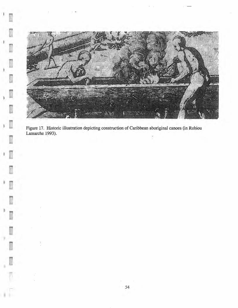
Aboriginal canoes were built of mahogany (Swistenia mahogany), cedar
(Cedrale odorata Gornier), silk cotton (Ceiba pentranda), and other fine
woods (Figure 12). The construction process often included the use of fire.
Prehistoric Caribbean navigation is discussed in detail by Robiou (1993). The
structural difference between river and seagoing canoes is discussed by Vega
t (1990, 1995), including the possible aboriginal invention of the pirogue or
keeled canoe.
The use of canoes extended well into the historic period, with rigged
pirogues used as late as the 191h century. Prehistoric or historic, the discovery
of a canoe in Puerto Rico's waters would be of primary significance, because
r 46
1,. ..
not one has been systematically excavated. Such a discovery might occur
practically anywhere in Puerto Rico's coastal waters, including beaches,
coastal shallows, ri ver mouths, reefs, lagoons, ports and under modern piers.
, 3.5 Known and Potential Prehistoric Sites at Punta Miquillo
The inventories of prehistoric sites at the State Historic Preservation
Office and the Consejo Arqueol6gico Terrestre report the presence of
prehistoric sites at Punta Miquillo and adjacent terrestrial areas.
The development of Punta MiquiIlo began in 1959. In order to fill the
mangrove swamp of the peninsula, dredging operations were conducted in
1962 at the Espiritu Santo River. The dredging was continued in 1966, now
including a channel around the peninsula of Punta Miquillo. The purpose of
this channel was to provide a safe waterway between the EspIritu Santo River
and Ensenada Comezon.
The dredging was continued until 1969. The steel-hulled vessel used for
dredging the channel was lost on the reef surrounding Punta Miquillo.
Presumably, the vessel was lost in 1969, on the rim of the reef .
• ~
The first archaeological study was conducted by Rodriguez Lopez (1980),
,. "
t for the Coco Beach residential development located SE of Punta Miquillo.
r ' , , ,
l ,
r 47 I
(., ..
During this investigation, Rodriguez Lopez detected surface archaeological
material at Punta Miquillo, on the west side of the peninsula, reported as Site
RG-S.
Additional studies at RG-5 were conducted by Rodriguez Morales (1988
and 1989), in order to assess the impact of filling operations on the site.
These initial studies were conducted per federal legislation, as Puerto Rico
Law Number 112 For the Protection of Terrestrial Archaeological Resources
was passed in 1988 (ICP 1991). This investigation detected another small
ceramic site near the south end of Punta Miquillo, reported as RG-8.
A Stage II investigation was conducted at RG-5 at by Daub6n Vidal
(1990), followed by additional Stage n research (Daubon Vidal 1992), and a
separate Stage I study for a panoramic lake south of the peninsulaand part of
the Coco Beach development (Daubon Vidal 1996).
Further investigations were coducted at Site RG-5 by Gmz Aguilu and
Martfn (1999a). This investigation identified the remnants of a small village
site, approximately 750 m long by 100 m wide, on the highest portion of
Punta Miquillo .
•
r •
48
,
The site was 30 to 120 em deep and was partly impacted by a dirt road,
filling operations, and erosion. The site consisted primarily of ceramic shards
and marine shell, with very few lithic tools and no fish bones.
The ceramics at RG-5 are mostly Santa Elena (Elenan Ostionoid) and
Esperanza (Chieoid or Chican), with a limited presence of Cuevas (late
Saladoid) and Monserrate (early Elenan Ostionoid). The Cuevas and
Monserrate ceramic shards were observed primarily on the west side of the
site, on the beach on Punta Miquillo.
The 1999 investigation reported the erosion of the edge of the RG-5,
including fallen palm trees and ceramics on the shoreline. Carefully
comparing his own excavation with previous studies, Ortiz Aguilu concluded
that some of the positive test units excavated by Rodriguez Miranda{l989) at
RG-5, are actually under water.
In 1999, OrtIZ Aguilu and Marfn conducted a Stage ill investigation at
Sector 2, a.k.a. El Palmar, immediately south of Ensenada Comezon, detecting
prehistoric ceramics. This was identified as a shallow, impacted site,
approximately 20-30 em deep, and reported in ICP site files as RG-6.
Also in 1999, OrtIZ Aguilu, Sued Badillo and Marfn conducted a Stage IA
background literature search for Sector 3, a.k.a. Cerro Bravo, a 186-cuerda
.ri
[ 49
plot on the coastal hills SE of Ensenada Comez6n. This was followed by a
Stage IB field investigation, detecting three small ceramic deposits (approx.lO
x 20 m in diameter) towards the west end of the plot, and a larger ceramic
midden (60 x 25 m) towards the east (OrtIZ Aguil6 and Marfn 2000). , It is evident that Punta Miquillo and the surrounding lowlands and hills
were occupied by prehistoric peoples, who certainly navigated the EspIritu
Santo River and the Ensenada Comez6n in their logout canoes.
The environmental history of Punta Miquillo is far more complex and
dynamic than the terrestrial archaeologists have considered. There is little
doubt that the peninsula of Punta Miquillo was formed between two rivers:
Espiritu Santo on the west side and a smaller stream on the east side.
The existence of this second river is evidenced by the actual creek known
today as Caiio de Rodriguez and Caiio de las Perchas in the 19th century. The
entrance to Ensenada Comez6n is not the product of 1960's dredging, but
rather is a flooded river channel or paleo-river which originally cut across the
eolianite dunes. The strongest evidence for this scenario are two submarine
canyons off Punta Miquillo, one directly off the mouthy of the Espiritu Santo
River and another directly off Ensenada Comez6n (Pease, Ir. and Briggs
1972). These canyons are signatures of paleo-rivers flooded by the rising sea
n 1101
r 50
level. A careful look at the geologic map (ibid.)indicates that the second river I
• ; ran parallel to Punta Miquillo and then veered NNE.
Seven thousand years ago, sea level was about -10 m, and the eolianite
ridges that surround Punta Miquillo would have been dry land. Preceramic
sites may be found in the vicinity of this paleo-river. These potential offshore
submerged preceramic sites, however, are beyond the area of potential adverse
effects of the proposed projects .
•
r 51
t •
10 ,
I 100
................. . ' '. ~ '. , ~
~ . . ~
t" •.•• "., ....
I \
.... / ........ . . . I ~
I ~
! \ I \
I , /' ,~ ~ . . ' .. '
-- .' 150~'~ MJd·_WfIClOlllln ~11on~ LIlt Wisconsin Rttrellion ~
50
Figure 15. Generalized eustatic sea level curve for the last 40,000 years (Komar 1976). Approximately 18,000 years ago, sea level dropped to nearly l30 m below present level, connecting the main island of Puerto Rico to Vieques, Culebra and all the U.S. and British Virgin Islands except St. Croix. By 7,000 BP, a moderate estimate for the beginning of human migration 'into the NE Caribbean, sea level was about -10 m. This data, combined with actual submerged archaeological sites discovered by the author off San Juan and Carolina, indicate the possibility of submerged prehistoric sites off and perhaps inside Ensenada Comez6n.
52
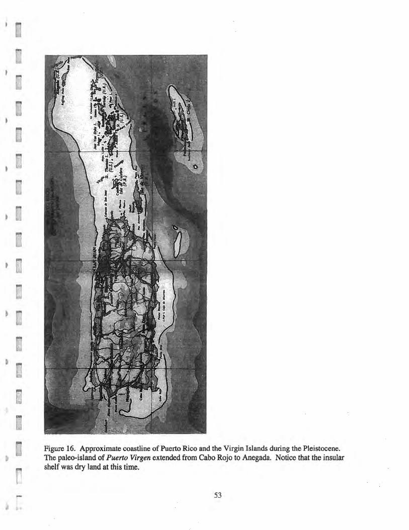
Figure 16. Approximate coastline of Puerto Rico and the Virgin Islands during the Pleistocene. The paleo-island of Puerto Virgen extended from Cabo Rojo to Anegada. Notice that the insular shelf was dry land at this time.
53
)
•
• I
r
Figure 17. Historic illustration depicting construction of Caribbean aboriginal canoes (in Robiou Lamarche 1993) .
54