Embed Size (px)
Citation preview
SOUTH DAKOTA TECHNICAL GUIDE NOTICE SD-278 SECTION I – REFERENCE LIST - TECHNICAL NOTES – ENGINEERING – PAGE 1 OF 17 APRIL 2009
TECHNICAL NOTE
HYDROLOGY TECHNICAL NOTE NO. 4 April 1, 2009
TILE GUIDELINES FOR PROTECTING WETLAND HYDROLOGY
COLIN NIEHUS, HYDRAULIC ENGINEER Background To participate in the Farm Bill, wetland hydrology must not be impacted by new drainage systems or by improvements to pre-December 23, 1985, drainage systems. In order to protect the wetland hydrology, any new or improved drainage systems must be located so that the inundation or saturation periods as specified by the applicable wetland hydrology criteria are not shortened. Hydrological analytical techniques such as scope and effect equations can be used to evaluate the hydrologic impacts to wetlands. According to 7 CFR 12.6, the Natural Resources Conservation Service (NRCS) can make a wetland determination using current federal wetland delineation methodology in use at the time of the determination and that are consistent with the current South Dakota (SD) Mapping Conventions. National Food Security Act Manual (NFSAM) criteria may be documented through use of indicators from the appropriate hydrology sections of the “Corps of Engineers Wetland Determination Manual” (Waterways Experiment Station Technical Engineers Report Y-87-1, January 1987) and the United States Army Corps of Engineers (COE) March 1992 guidance to the field “Clarification and Interpretation of the 1987 Manual.” In addition, the following analytical techniques may be used to supplement indicators and procedures found in the COE 1987 Manual. These techniques are outlined in the Hydrology Tools for Wetland Delineation Manual: a. Use of Stream and Lake Gages b. Runoff Volumes c. Remote Sensing d. DRAINMOD e. Scope and Effect Equations f. NRCS Drainage Guides g. Observation Wells In SD, the scope and effect equation used to evaluate tile systems is the van Schilfgaarde equation by means of the DRAIN program. The DRAIN program is the result of the combined efforts of SD, North Dakota, Minnesota, and Iowa, to achieve consistency between the states in the evaluation of scope and effect on wetland hydrology due to lateral effects of subsurface drainage features. The van Schilfgaarde equation is used to compute tile lateral effect distances, which are the distances on either side of the tile line that the tile effectively drains the subsurface water. Lateral effect tables for typical tile sizes and depths with slope adjustments are available in the SD Technical Guide (SDTG) (eFOTG) in Section I, H. Resource Evaluation Tools. It is recommended that slope adjustments for ground surface slope to the lateral effect distance be used as deemed necessary.
SOUTH DAKOTA TECHNICAL GUIDE NOTICE SD-278 SECTION I – REFERENCE LIST - TECHNICAL NOTES – ENGINEERING – PAGE 2 OF 17 APRIL 2009
Introduction Previously, Hydrology Technical Note No. 4 dated March 26, 2003, was created by the NRCS, in SD, to provide consistent guidelines for protecting wetland hydrology from new or improved tile systems. In response to questions concerning this note, Hydrology Technical Note No. 4 has been revised via this document. Accordingly, the original technical note dated March 26, 2003, is void and should no longer be used. Procedures outlined in this revised technical note are only guidelines to ensure protection of wetland hydrology. Whenever possible and/or practical, excavation and tile in and/or near wetlands should be minimized. The final determination of how to protect wetland hydrology from new and/or improved tiling systems must be done in consultation with any applicable federal laws and regulations, the NFSAM, professional judgment, and experience. The protection of wetlands from tile drainage systems must be well documented. The utilization of the Tile Installation Agreement in the Appendix is one way to document that wetland hydrology was not impacted by new tile systems. In this form, there is a list of many requirements and precautions when tiling near wetlands including requirements (if Clean Water Act is applicable) that the COE be contacted before tile installations to request permits for the activities, that all federal (non-Farm Bill), state, county, and other local regulations have been followed, and how to document that Farm Bill requirements have been met in connection with wetland protection. The following sections illustrate wetland protection for typical scenarios that are encountered when tiling near wetlands. The topics covered include: tiling around wetlands, exceptions to the one lateral effect distance requirements, tiling through wetlands, outletting tile in wetlands, and outletting tile to Not Inventoried (NI) areas (potential United States Waters). The basic requirement for all these typical scenarios is that wetland hydrology must not be impacted by tiling. Note that NGS is an abbreviation for Natural Ground Surface for all cross sections in this document.
SOUTH DAKOTA TECHNICAL GUIDE NOTICE SD-278 SECTION I – REFERENCE LIST - TECHNICAL NOTES – ENGINEERING – PAGE 3 OF 17 APRIL 2009
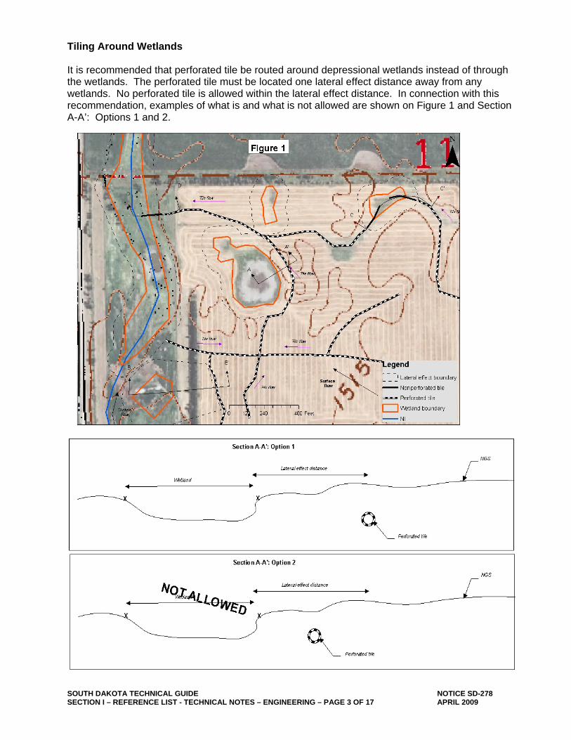
Tiling Around Wetlands It is recommended that perforated tile be routed around depressional wetlands instead of through the wetlands. The perforated tile must be located one lateral effect distance away from any wetlands. No perforated tile is allowed within the lateral effect distance. In connection with this recommendation, examples of what is and what is not allowed are shown on Figure 1 and Section A-A’: Options 1 and 2.
SOUTH DAKOTA TECHNICAL GUIDE NOTICE SD-278 SECTION I – REFERENCE LIST - TECHNICAL NOTES – ENGINEERING – PAGE 4 OF 17 APRIL 2009
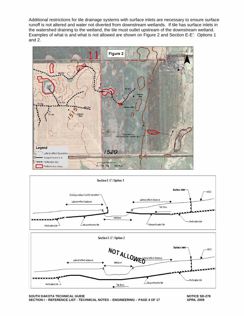
Additional restrictions for tile drainage systems with surface inlets are necessary to ensure surface runoff is not altered and water not diverted from downstream wetlands. If tile has surface inlets in the watershed draining to the wetland, the tile must outlet upstream of the downstream wetland. Examples of what is and what is not allowed are shown on Figure 2 and Section E-E’: Options 1 and 2.
SOUTH DAKOTA TECHNICAL GUIDE NOTICE SD-278 SECTION I – REFERENCE LIST - TECHNICAL NOTES – ENGINEERING – PAGE 5 OF 17 APRIL 2009
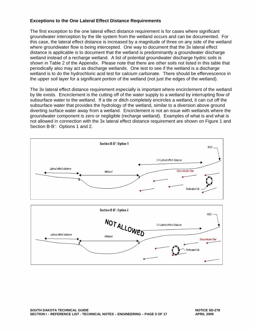
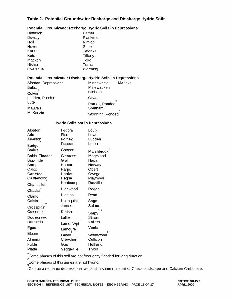
Exceptions to the One Lateral Effect Distance Requirements The first exception to the one lateral effect distance requirement is for cases where significant groundwater interception by the tile system from the wetland occurs and can be documented. For this case, the lateral effect distance is increased by a magnitude of three on any side of the wetland where groundwater flow is being intercepted. One way to document that the 3x lateral effect distance is applicable is to document that the wetland is predominantly a groundwater discharge wetland instead of a recharge wetland. A list of potential groundwater discharge hydric soils is shown in Table 2 of the Appendix. Please note that there are other soils not listed in this table that periodically also may act as discharge wetlands. One test to see if the wetland is a discharge wetland is to do the hydrochloric acid test for calcium carbonate. There should be effervescence in the upper soil layer for a significant portion of the wetland (not just the edges of the wetland). The 3x lateral effect distance requirement especially is important where encirclement of the wetland by tile exists. Encirclement is the cutting off of the water supply to a wetland by interrupting flow of subsurface water to the wetland. If a tile or ditch completely encircles a wetland, it can cut off the subsurface water that provides the hydrology of the wetland, similar to a diversion above ground diverting surface water away from a wetland. Encirclement is not an issue with wetlands where the groundwater component is zero or negligible (recharge wetland). Examples of what is and what is not allowed in connection with the 3x lateral effect distance requirement are shown on Figure 1 and Section B-B’: Options 1 and 2.
SOUTH DAKOTA TECHNICAL GUIDE NOTICE SD-278 SECTION I – REFERENCE LIST - TECHNICAL NOTES – ENGINEERING – PAGE 6 OF 17 APRIL 2009
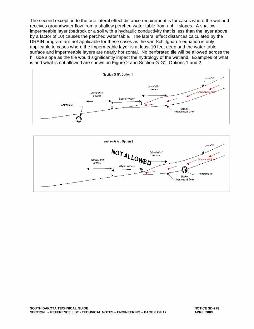
The second exception to the one lateral effect distance requirement is for cases where the wetland receives groundwater flow from a shallow perched water table from uphill slopes. A shallow impermeable layer (bedrock or a soil with a hydraulic conductivity that is less than the layer above by a factor of 10) causes the perched water table. The lateral effect distances calculated by the DRAIN program are not applicable for these cases as the van Schilfgaarde equation is only applicable to cases where the impermeable layer is at least 10 feet deep and the water table surface and impermeable layers are nearly horizontal. No perforated tile will be allowed across the hillside slope as the tile would significantly impact the hydrology of the wetland. Examples of what is and what is not allowed are shown on Figure 2 and Section G-G’: Options 1 and 2.
SOUTH DAKOTA TECHNICAL GUIDE NOTICE SD-278 SECTION I – REFERENCE LIST - TECHNICAL NOTES – ENGINEERING – PAGE 7 OF 17 APRIL 2009
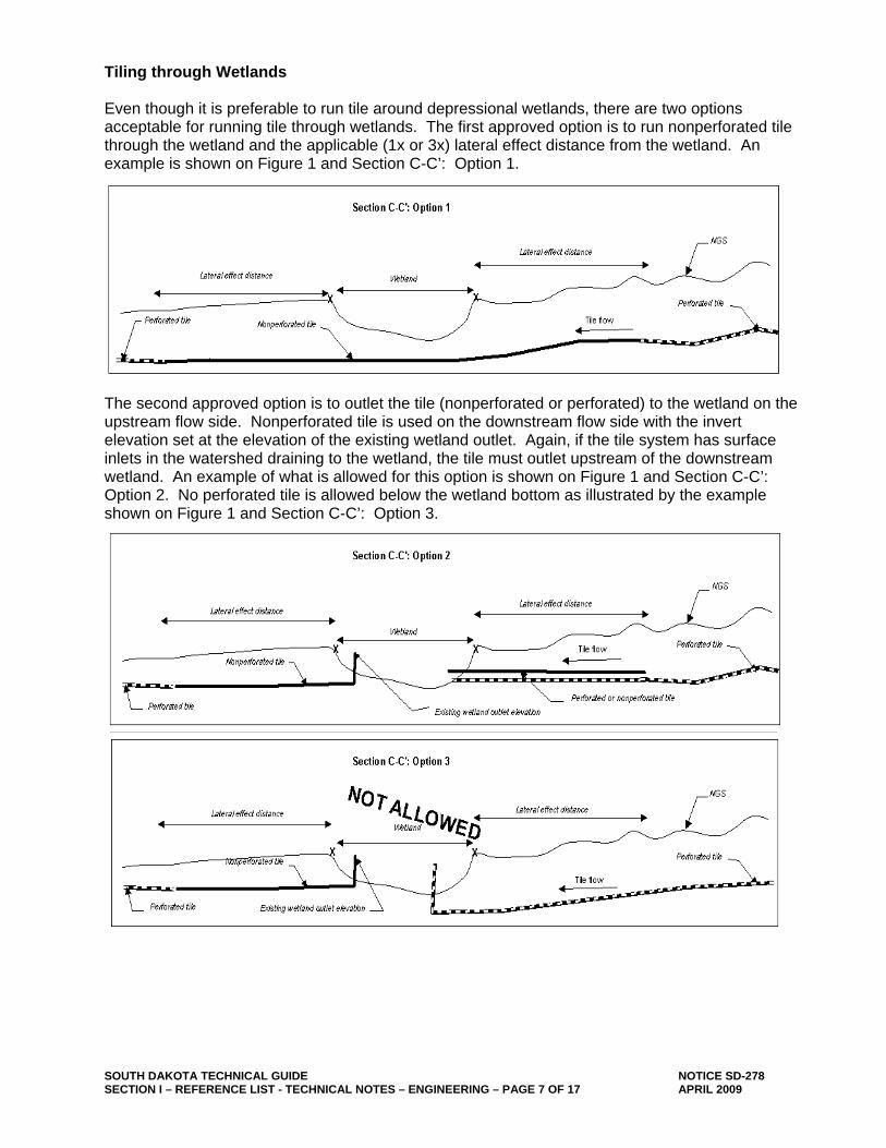
Tiling through Wetlands Even though it is preferable to run tile around depressional wetlands, there are two options acceptable for running tile through wetlands. The first approved option is to run nonperforated tile through the wetland and the applicable (1x or 3x) lateral effect distance from the wetland. An example is shown on Figure 1 and Section C-C’: Option 1.
The second approved option is to outlet the tile (nonperforated or perforated) to the wetland on the upstream flow side. Nonperforated tile is used on the downstream flow side with the invert elevation set at the elevation of the existing wetland outlet. Again, if the tile system has surface inlets in the watershed draining to the wetland, the tile must outlet upstream of the downstream wetland. An example of what is allowed for this option is shown on Figure 1 and Section C-C’: Option 2. No perforated tile is allowed below the wetland bottom as illustrated by the example shown on Figure 1 and Section C-C’: Option 3.
SOUTH DAKOTA TECHNICAL GUIDE NOTICE SD-278 SECTION I – REFERENCE LIST - TECHNICAL NOTES – ENGINEERING – PAGE 8 OF 17 APRIL 2009
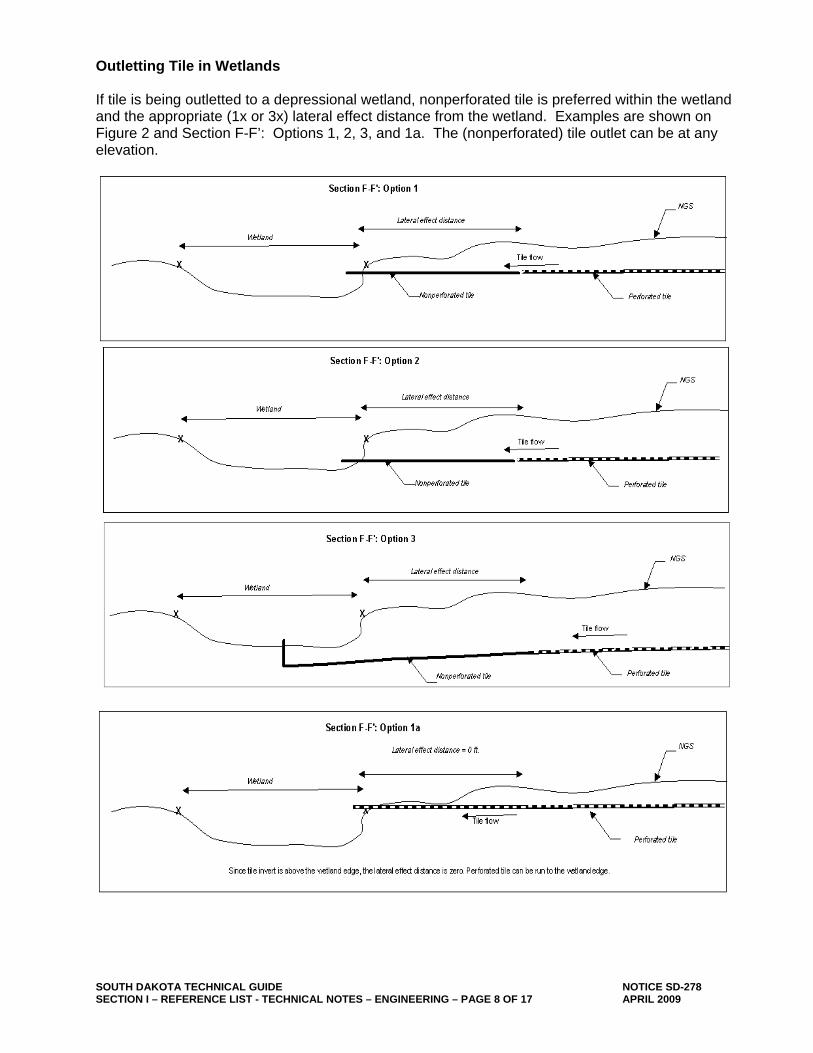
Outletting Tile in Wetlands If tile is being outletted to a depressional wetland, nonperforated tile is preferred within the wetland and the appropriate (1x or 3x) lateral effect distance from the wetland. Examples are shown on Figure 2 and Section F-F’: Options 1, 2, 3, and 1a. The (nonperforated) tile outlet can be at any elevation.
SOUTH DAKOTA TECHNICAL GUIDE NOTICE SD-278 SECTION I – REFERENCE LIST - TECHNICAL NOTES – ENGINEERING – PAGE 9 OF 17 APRIL 2009
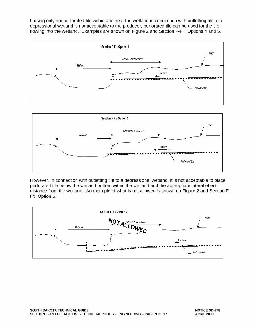
If using only nonperforated tile within and near the wetland in connection with outletting tile to a depressional wetland is not acceptable to the producer, perforated tile can be used for the tile flowing into the wetland. Examples are shown on Figure 2 and Section F-F’: Options 4 and 5.
However, in connection with outletting tile to a depressional wetland, it is not acceptable to place perforated tile below the wetland bottom within the wetland and the appropriate lateral effect distance from the wetland. An example of what is not allowed is shown on Figure 2 and Section F-F’: Option 6.
SOUTH DAKOTA TECHNICAL GUIDE NOTICE SD-278 SECTION I – REFERENCE LIST - TECHNICAL NOTES – ENGINEERING – PAGE 10 OF 17 APRIL 2009
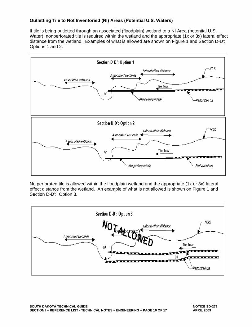
Outletting Tile to Not Inventoried (NI) Areas (Potential U.S. Waters) If tile is being outletted through an associated (floodplain) wetland to a NI Area (potential U.S. Water), nonperforated tile is required within the wetland and the appropriate (1x or 3x) lateral effect distance from the wetland. Examples of what is allowed are shown on Figure 1 and Section D-D’: Options 1 and 2.
No perforated tile is allowed within the floodplain wetland and the appropriate (1x or 3x) lateral effect distance from the wetland. An example of what is not allowed is shown on Figure 1 and Section D-D’: Option 3.
SOUTH DAKOTA TECHNICAL GUIDE NOTICE SD-278 SECTION I – REFERENCE LIST - TECHNICAL NOTES – ENGINEERING – PAGE 11 OF 17 APRIL 2009
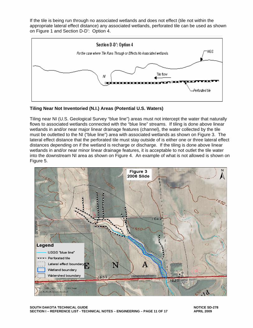
If the tile is being run through no associated wetlands and does not effect (tile not within the appropriate lateral effect distance) any associated wetlands, perforated tile can be used as shown on Figure 1 and Section D-D’: Option 4.
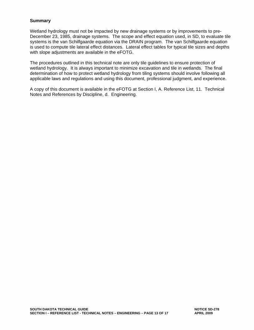
Tiling Near Not Inventoried (N.I.) Areas (Potential U.S. Waters) Tiling near NI (U.S. Geological Survey “blue line”) areas must not intercept the water that naturally flows to associated wetlands connected with the “blue line” streams. If tiling is done above linear wetlands in and/or near major linear drainage features (channel), the water collected by the tile must be outletted to the NI (“blue line”) area with associated wetlands as shown on Figure 3. The lateral effect distance that the perforated tile must stay outside of is either one or three lateral effect distances depending on if the wetland is recharge or discharge. If the tiling is done above linear wetlands in and/or near minor linear drainage features, it is acceptable to not outlet the tile water into the downstream NI area as shown on Figure 4. An example of what is not allowed is shown on Figure 5.

SOUTH DAKOTA TECHNICAL GUIDE NOTICE SD-278 SECTION I – REFERENCE LIST - TECHNICAL NOTES – ENGINEERING – PAGE 12 OF 17 APRIL 2009
SOUTH DAKOTA TECHNICAL GUIDE NOTICE SD-278 SECTION I – REFERENCE LIST - TECHNICAL NOTES – ENGINEERING – PAGE 13 OF 17 APRIL 2009
Summary Wetland hydrology must not be impacted by new drainage systems or by improvements to pre-December 23, 1985, drainage systems. The scope and effect equation used, in SD, to evaluate tile systems is the van Schilfgaarde equation via the DRAIN program. The van Schilfgaarde equation is used to compute tile lateral effect distances. Lateral effect tables for typical tile sizes and depths with slope adjustments are available in the eFOTG. The procedures outlined in this technical note are only tile guidelines to ensure protection of wetland hydrology. It is always important to minimize excavation and tile in wetlands. The final determination of how to protect wetland hydrology from tiling systems should involve following all applicable laws and regulations and using this document, professional judgment, and experience. A copy of this document is available in the eFOTG at Section I, A. Reference List, 11. Technical Notes and References by Discipline, d. Engineering.
SOUTH DAKOTA TECHNICAL GUIDE NOTICE SD-278 SECTION I – REFERENCE LIST - TECHNICAL NOTES – ENGINEERING – PAGE 14 OF 17 APRIL 2009
APPENDIX Tile Installation Agreement
Landowner:____________________________________________________ Date:__________________ Legal Description:_______________________________________________ Tract Number(s):_________ This agreement is to stipulate the conditions to install drainage tile near or through wetland areas. The following terms must be followed to ensure that wetlands are not impacted by tile drainage and that the landowner and/or operator do not jeopardize present and/or future United States Department of Agriculture (USDA) Farm Program benefits. This agreement is only for USDA purposes and is not a state, county, or local drainage permit. Items to be completed prior to signing this agreement: 1. The landowner will file with the Farm Service Agency (FSA) an AD-1026, Highly Erodible Land
Conservation and Wetland Conservation Certification, describing the planned tile drainage system. 2. The landowner will provide the NRCS with a detailed plan map for evaluation purposes that includes all
tile routes, sizes, types, depths, and surface inlets and outlets prior to tile installation. 3. The landowner will allow NRCS personnel permission to enter the property described above to determine
the extent of existing and proposed drainage. 4. If no certified wetland determination exists, the landowner must request a certified wetland determination
or delineation and allow NRCS personnel permission to enter the property described above to make the determination.
By signing this agreement, you are agreeing to the following terms: 1. The above items (1-4) have been addressed. 2. The landowner will contact the COE before tile installation to request a permit for the activity, if needed. 3. The landowner will ensure that other federal, state, county, and other local regulations have been
followed. 4. The tile system will be installed as shown on the attached map. This map shows landowner-NRCS final
agreed upon tile routes, sizes, and types; any required tiling restrictions; and any surface inlets and outlets.
5. The tiler must stake the project and allow NRCS personnel to inspect the route prior to installation. Any required nonperforated tile will be flagged off.
6. NRCS personnel will be allowed to inspect and verify tile installation. Following tile installation the landowner or operator will provide NRCS an "as installed" map certifying the location of both perforated and nonperforated tile. If nonperforated tile is required, the landowner or operator shall provide NRCS with receipts showing that nonperforated tile was purchased for the applicable tract.
7. Lateral effect distances will be as specified in attached Table 1. The applicable distances depend on the soil type and effective depth of the drain. Note that there are additional wetland restrictions for tile drainage systems that have surface inlets and for wetlands that receive substantial groundwater (groundwater discharge wetlands and slope wetlands). These restrictions may include requiring increased lateral effect distances, outletting the tile system to the wetland, and/or allowing no tiling in the upstream or lateral land area where the groundwater is coming from unless the tiling system outlets on the upstream end of the wetland.
Landowner Signature:___________________________________________ Date:___________________ Inspected by:____________________________________________(NRCS) Date:___________________ Agreement terms met? YES NO Comments:_____________________________________________________________________________ ______________________________________________________________________________________
SOUTH DAKOTA TECHNICAL GUIDE NOTICE SD-278 SECTION I – REFERENCE LIST - TECHNICAL NOTES – ENGINEERING – PAGE 15 OF 17 APRIL 2009
Table 1: Lateral Effect Distances Landowner:___________________________________________ Tract Number(s):________________ Legal Description:________________________________________ County:________________________ Prepared by:_____________________________________________ Date:__________________________
Lateral Effect Distance (ft.) Soil Name Soil
Symbol S5ID 2 ft. Depth1
3 ft. Depth1
4 ft. Depth1
5 ft. Depth1
Notes
1Effective depth: elevation at the edge of the wetland minus the elevation of the tile invert. Lateral Effect Distance Lateral Effect Distance
SOUTH DAKOTA TECHNICAL GUIDE NOTICE SD-278 SECTION I – REFERENCE LIST - TECHNICAL NOTES – ENGINEERING – PAGE 16 OF 17 APRIL 2009
Table 2. Potential Groundwater Recharge and Discharge Hydric Soils Potential Groundwater Recharge Hydric Soils in Depressions Dimmick Parnell Dovray Plankinton Heil Rimlap Hoven Shue Kolls Tetonka Koto Tiffany Macken Toko Nishon Tonka Overshue Worthing Potential Groundwater Discharge Hydric Soils in Depressions Albaton, Depressional Minnewasta Marlake Baltic Minewauken Colvin
3 Oldham
Ludden, Ponded Orwet Lute Parnell, Ponded
3
Mauvais Southam McKenzie Worthing, Ponded
3
Hydric Soils not in Depressions
Albaton Fedora Loup Arlo Flom Lowe Arveson Forney Ludden
Badger2 Fossum Luton
Badus Gannett Marshbrook2
Baltic, Flooded Glenross Marysland Bigwinder Grat Napa Borup Hamar Norway Calco Harps Obert Canisteo Harriet Owego Castlewood Hegne Playmoor
Chancellor2 Herdcamp Rauville
Chaska2 Hidewood Regan
Clamo2 Higgins Ryan
Colvin Holmquist Sage
Crossplain2 James Salmo
Cutcomb Kratka Sarpy1, 2
Dogiecreek Lallie Stirum Durrstein Lamo, Wet
2 Vallers
Egas Lamoure2 Venlo
Elpam Lawet2 Whitewood
2
Almeria Crowther Cullison Fulda Gus Hoffland Platte Sedgeville Tryon 1Some phases of this soil are not frequently flooded for long duration.
2Some phases of this series are not hydric.
3Can be a recharge depressional wetland in some map units. Check landscape and Calcium Carbonate.
SOUTH DAKOTA TECHNICAL GUIDE NOTICE SD-278 SECTION I – REFERENCE LIST - TECHNICAL NOTES – ENGINEERING – PAGE 17 OF 17 APRIL 2009
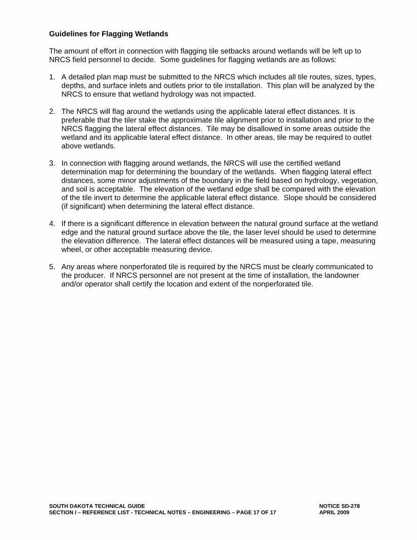
Guidelines for Flagging Wetlands The amount of effort in connection with flagging tile setbacks around wetlands will be left up to NRCS field personnel to decide. Some guidelines for flagging wetlands are as follows: 1. A detailed plan map must be submitted to the NRCS which includes all tile routes, sizes, types,
depths, and surface inlets and outlets prior to tile installation. This plan will be analyzed by the NRCS to ensure that wetland hydrology was not impacted.
2. The NRCS will flag around the wetlands using the applicable lateral effect distances. It is
preferable that the tiler stake the approximate tile alignment prior to installation and prior to the NRCS flagging the lateral effect distances. Tile may be disallowed in some areas outside the wetland and its applicable lateral effect distance. In other areas, tile may be required to outlet above wetlands.
3. In connection with flagging around wetlands, the NRCS will use the certified wetland
determination map for determining the boundary of the wetlands. When flagging lateral effect distances, some minor adjustments of the boundary in the field based on hydrology, vegetation, and soil is acceptable. The elevation of the wetland edge shall be compared with the elevation of the tile invert to determine the applicable lateral effect distance. Slope should be considered (if significant) when determining the lateral effect distance.
4. If there is a significant difference in elevation between the natural ground surface at the wetland
edge and the natural ground surface above the tile, the laser level should be used to determine the elevation difference. The lateral effect distances will be measured using a tape, measuring wheel, or other acceptable measuring device.
5. Any areas where nonperforated tile is required by the NRCS must be clearly communicated to
the producer. If NRCS personnel are not present at the time of installation, the landowner and/or operator shall certify the location and extent of the nonperforated tile.


![[hydrology] groundwater hydrology - david k. todd (2005).pdf](https://img.pdfslide.us/doc/110x75/577c77961a28abe0548cb0b1/hydrology-groundwater-hydrology-david-k-todd-2005pdf.jpg)

![[Hydrology] Groundwater Hydrology - David K. Todd (2005)](https://img.pdfslide.us/doc/110x75/548ce7beb47959e2288b45f9/hydrology-groundwater-hydrology-david-k-todd-2005.jpg)


![[Hydrology] groundwater hydrology david k. todd (2005)](https://img.pdfslide.us/doc/110x75/55a8e6001a28ab6c2f8b4687/hydrology-groundwater-hydrology-david-k-todd-2005-55b0d9a792c06.jpg)