Embed Size (px)
Citation preview

Hydrology Science and Applications from the Surface Water and Ocean Topography (SWOT) Mission
Tamlin M. PavelskyJean-Francois Cretaux
Lakes, Climate, and Remote Sensing WorkshopJune 1-2, 2017

The Surface Water and Ocean Topography Mission� Joint satellite mission of NASA,
CNES, CSA/ASC, and UKSA� 21-day repeat orbit at 890 km. � Launch currently planned in April
2021� 3.5 year nominal mission lifetime.� Native azimuth resolution of 5.5 m� Native range resolution of 70 m to
10 m� Simultaneously measures
inundation extent and water surface elevation
� Total budget: ~$1.1B
The principal payload on SWOT is a Ka-band Radar Interferometer (KaRIn) operating at 35.75 GHz (8.6 mm) with twin 50 km swaths pointing 1-4.5° off nadir.
Biancamaria, Lettenmaier, and Pavelsky, SoG, 2015
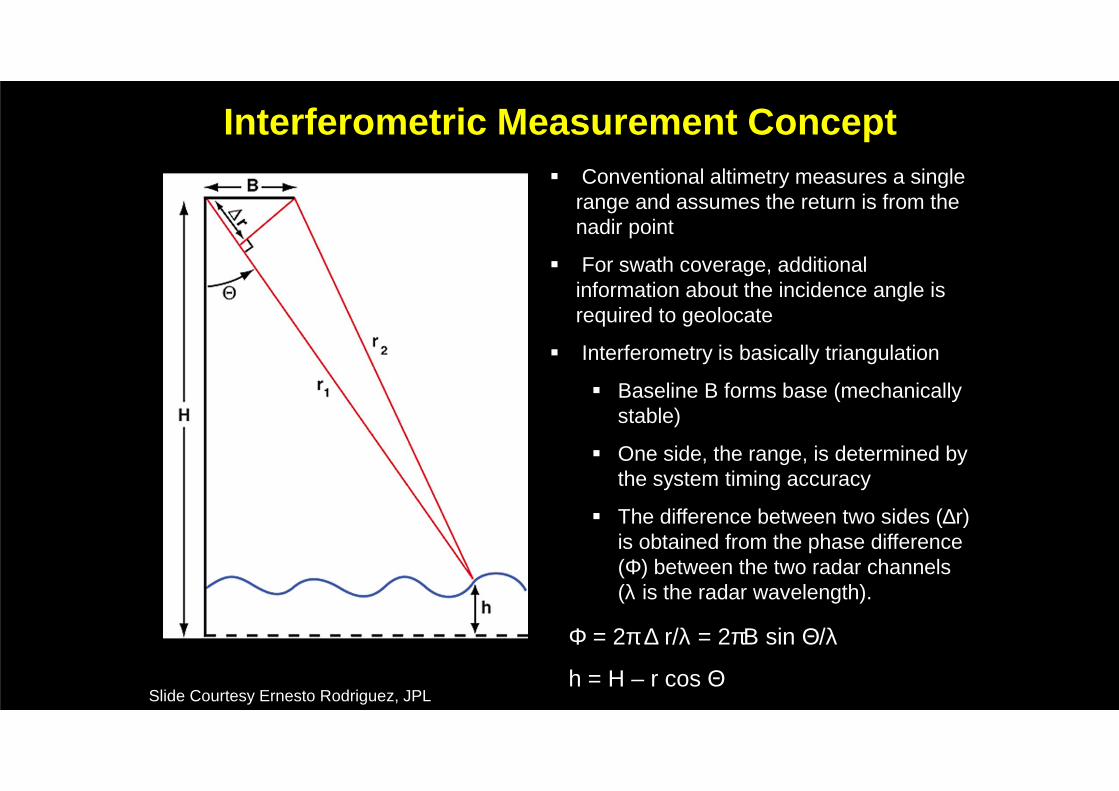
Interferometric Measurement Concept� Conventional altimetry measures a single
range and assumes the return is from the nadir point
� For swath coverage, additional information about the incidence angle is required to geolocate
� Interferometry is basically triangulation
� Baseline B forms base (mechanically stable)
� One side, the range, is determined by the system timing accuracy
� The difference between two sides (∆r) is obtained from the phase difference (Φ) between the two radar channels (λ is the radar wavelength).
Φ = 2π ∆ r/λ = 2πΒ sin Θ/λ
h = H – r cos ΘSlide Courtesy Ernesto Rodriguez, JPL

SWOT Revisits per 21-day Cycle
The 120 km wide SWOT swath will result in overlapping measurements over most of the globe. The result: an average revisit time of 11 days.
Source: Biancamaria et al., SoG, 2016
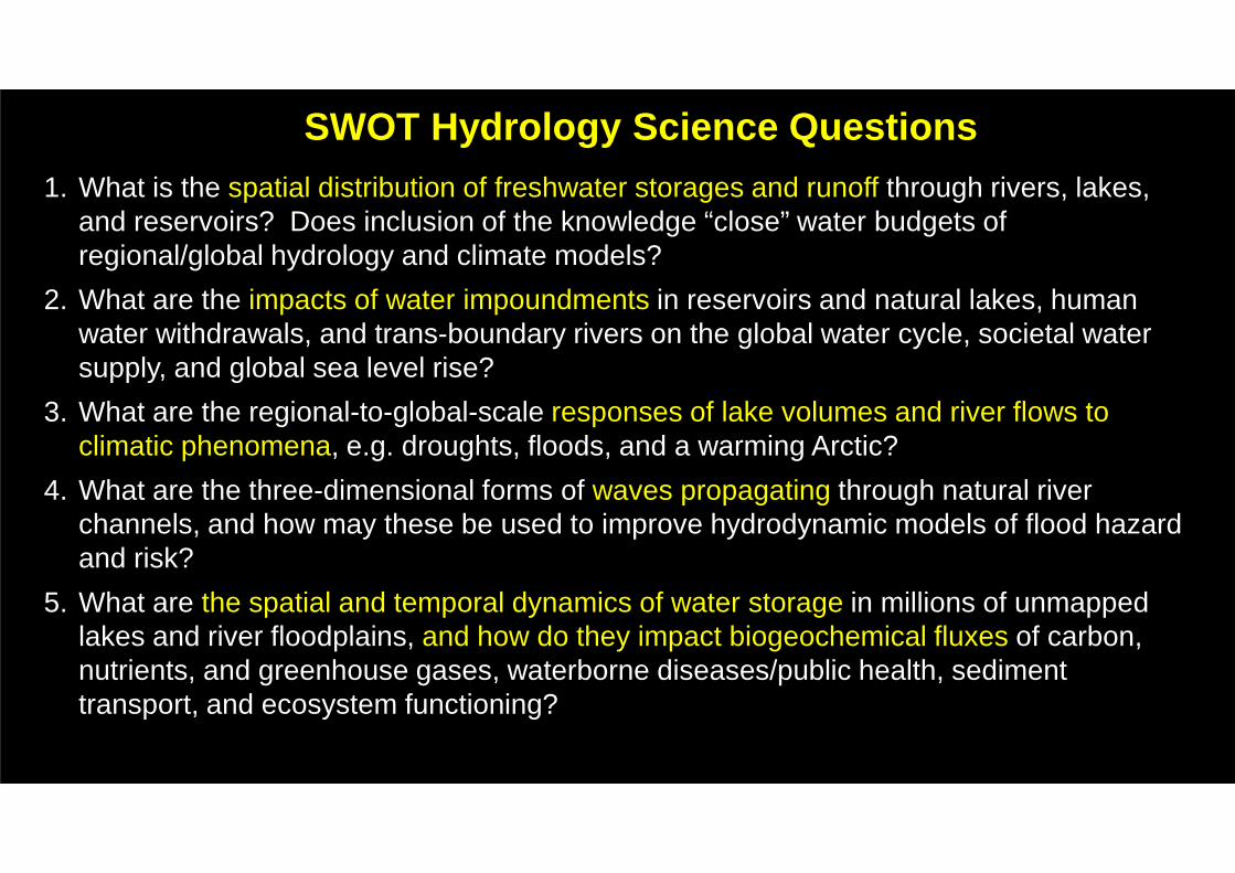
SWOT Hydrology Science Questions1. What is the spatial distribution of freshwater storages and runoff through rivers, lakes,
and reservoirs? Does inclusion of the knowledge “close” water budgets of regional/global hydrology and climate models?
2. What are the impacts of water impoundments in reservoirs and natural lakes, human water withdrawals, and trans-boundary rivers on the global water cycle, societal water supply, and global sea level rise?
3. What are the regional-to-global-scale responses of lake volumes and river flows to climatic phenomena, e.g. droughts, floods, and a warming Arctic?
4. What are the three-dimensional forms of waves propagating through natural river channels, and how may these be used to improve hydrodynamic models of flood hazard and risk?
5. What are the spatial and temporal dynamics of water storage in millions of unmapped lakes and river floodplains, and how do they impact biogeochemical fluxes of carbon, nutrients, and greenhouse gases, waterborne diseases/public health, sediment transport, and ecosystem functioning?

SWOT Measurement Capabilities for Rivers
� Inundated Area/River Width:� 15% error for 100 m
wide rivers over a 10 km reach.
� Water surface elevation::
� 10 cm error for 1 km2
area and 25 cm error for between (250 m)2 and 1 km2.
� Water surface slope:
� 17 µrad error for 100 m wide river over 10 km.
Source: Allen and Pavelsky, GRL (2015)

Estimating River Discharge from SWOT
SWOT measurement of water surface elevation, slope, and river width provides many of the pieces of information required to estimate discharge using Manning’s equation (or a similar formulation):
Q ≈ (∂A+ A0 )5/3 w−2/3S1/2
n
Ongoing work led by Mike Durand (Ohio State), Colin Gleason (U. Mass), Pierre-Andre Garambois (Strasbourg), and other members of the science team is producing promising estimates of river discharge from SWOT.

01-2008 03-2008 05-2008 07-2008 09-2008 11-2008Time
010
000
2000
030
000
4000
050
000
6000
0
Flow
(m
3 /s)
Observations RAPID with parameters optimized over 2008 on all 14 stations (runoff from VIC-4.0.3) RAPID with parameters optimized over 2008 on the best 6 stations (runoff from VIC-4.0.3)
Ohio River at Metropolis, IL
Rap
idM
GB
-IP
HH
RR
Estimating River Discharge from SWOT
Preliminary work suggests that assimilation of SWOT data into hydrodynamic models can help to improve simulation of streamflow in a range of model environments.
Figures courtesy Cedric David, JPL

Pavelsky et al., 2014, J. Hydrology
SWOT River Coverage Globally
Globally, SWOT will likely improve monitoring of rivers, especially for river basins between 25,000 and 250,000 km2.
Comparison the fraction of river basins of different sizes likely to be observed by SWOT (blue) and currently included in the Global Runoff Data Centre (GRDC) database (red) suggests that SWOT is likely to substantially improve global river measurement capabilities.

Courtesy Yongwei Sheng, UCLA
Organizing the World’s Water: Lakes
Systematic ground-based water surface elevations: a few thousand lakes globally. No central data repository exists.
Insufficient to:� Characterize lake-
based water resources
� Use lakes to improve understanding of the water cycle.

SWOT Measurement Capabilities for Lakes
� Inundated Area:� 15% accuracy for lakes
larger than (250 m)2
� Lake Water Surface Height:� 10 cm accuracy for lakes
larger than 1 km2 and 25 cm accuracy for lakes between 1 km2 and (250m)2
Source: Biancamaria et al., SoG, 2016
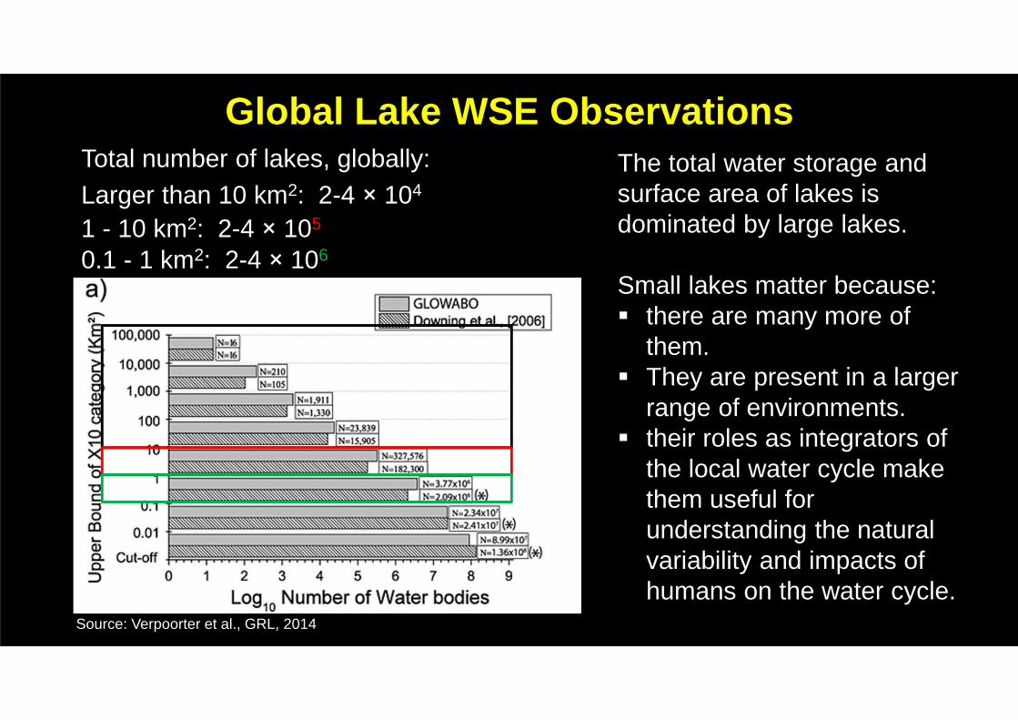
Global Lake WSE Observations
Source: Verpoorter et al., GRL, 2014
Total number of lakes, globally:Larger than 10 km2: 2-4 × 10⁴
1 - 10 km2: 2-4 × 10⁵
0.1 - 1 km2: 2-4 × 10⁶
The total water storage and surface area of lakes is dominated by large lakes.
Small lakes matter because:� there are many more of
them.� They are present in a larger
range of environments.� their roles as integrators of
the local water cycle make them useful for understanding the natural variability and impacts of humans on the water cycle.

SWOT Lake Measurements
Figure Courtesy Yongwei Sheng, UCLA
Preliminary analysis factoring in SWOT orbit characteristics and the effects of topography suggests that:� Most low-latitude lakes will be observed
twice during any 21 day orbit. � High latitude lakes likely to be observed
more frequently.� Large lakes will be at least partially
observed many times during a 21-day repeat cycle.
� Many small mountain lakes will not be well observed due to layover.

� AirSWOT is an airborne SWOT analogue and a primary SWOT calibration and validation tool.
� Primary payload is the Ka-band SWOT Phenomenology Airborne Radar (KaSPAR)
� Secondary payload is a NASA Color/IR Digital Cirrus Camera
� Integrated on a NASA King Air B200 out of NASA Armstrong
Pitcher et al., in prep
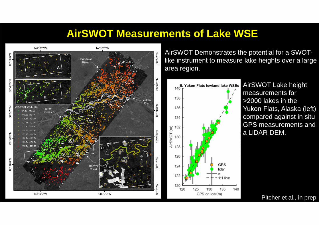
AirSWOT Measurements of Lake WSE
AirSWOT Demonstrates the potential for a SWOT-like instrument to measure lake heights over a large area region.
AirSWOT Lake height measurements for >2000 lakes in the Yukon Flats, Alaska (left) compared against in situ GPS measurements and a LiDAR DEM.

Cedric David et al., Preparing for the ingestion of SWOT data into continental-
scale river models. H21F-1477.
Charlotte Emery et al., Contribution Of The SWOT Mission To Large-Scale
Hydrological Modeling Using Data Assimilation. H21F-1479.
Daiki Ikeshima et al., Global SWOT Data Assimilation of River Hydrodynamic
Model; the Twin Simulation Test of CaMa-Flood. H21F-1478.
Hind Oubanas et al., Simultaneous estimation of inflow discharge, river
bathymetry and friction from synthetic SWOT data using variational data
assimilation H21F-1478
Fulvia Baratelli et al., Distributed Baseflow Estimation for a Regional Basin in the
Context of the SWOT Hydrology Mission H21F-1481
Colby Fisher et al., How well will SWOT observe global river basins? H21L-08.
9:29-9:44.
Stephen Coss et al., GRRATS: A new approach to inland altimetry processing for
major world rivers H21F-1474
Christine Lion et al., Developing a Global Network of River Reaches in
Preparation of SWOT H21F-1484
Renato Frasson et al. Impacts of river segmentation strategies on reach-averaged
product uncertainties for the upcoming Surface Water and Ocean Topography
(SWOT) mission H21F-1485
Ed Beighley et al., Integrating lateral contributions along river reaches
to improve SWOT discharge estimates. H21F-1488
Michael Durand et al. Including stage-dependent roughness
coefficient in algorithms to estimate river discharge from
remotely sensed water elevation, width, and slope. H21F-1487
Julian Simeonov, Remote Estimation of River Discharge and
Bathymetry: Sensitivity to Turbulent Dissipation and Bottom Friction
H21F-1486
Chaopeng Shen et al. Geomorphological significance and predictions
of at-many-stations hydraulic geometry H21F-1492
Colin Gleason et al., Forward to the Future: Estimating River Discharge
with McFLI. H21L-06. 8:59-9:14
Pierre-Andre Garambois et al., Variational Assimilation of Sparse and
Uncertain Satellite Data For 1D Saint-Venant River Models. H21L-07.
9:14-9:29.
Stephen Tuozzolo et al., Characterizing AirSWOT water elevation accuracy on the Willamette River H21F-1482
Elizabeth Altenau et al., Novel AirSWOT Measurements of River Height and Slope, Tanana River, AK H21F-1483
SWOT River Presentations, AGU 2016

Natan Holtzman et al., Predicting Lake Depths from
Topography to Map Global Lake Volume, H21F-1491
Yongwei Sheng et al. Where and in What Quantity Are
Lakes Observable by SWOT? H21L-09 9:44-9:59
Matthew Bonnema and Fasial Hossain, Assessing the
Benefits Provided by SWOT Data Towards Estimating
Reservoir Residence Time in the Mekong River Basin,
H21F-1476
SWOT Lake Presentations, AGU 2016
We need a more unified community focused on remote sensing of lakes that also interacts with SWOT and other upcoming satellite missions


![PIA 1992 308-1484-1-PB[1]](https://img.pdfslide.us/doc/110x75/577d20431a28ab4e1e9263ce/pia-1992-308-1484-1-pb1.jpg)