Embed Size (px)
Citation preview

Hydrology and Hydrogeology
of Navajo Lake
Kane County, Utah
GEOLOGICAL SURVEY PROFESSIONAL PAPER 417-C
Prepared in cooperation with the Utah Water and
Power Board and with the Cedar City Corporation
Hydrology and Hydrogeology
of Navajo Lake
Kane County, UtahBy M. T. WILSON and H. E. THOMAS
CONTRIBUTIONS TO STREAM-BASIN HYDROLOGY
GEOLOGICAL SURVEY PROFESSIONAL PAPER 417-C
Prepared in cooperation with the Utah If^ater and
Power Board and with the Cedar City Corporation
UNITED STATES GOVERNMENT PRINTING OFFICE, WASHINGTON : 1964

UNITED STATES DEPARTMENT OF THE INTERIOR
STEWART L. UDALL, Secretary
GEOLOGICAL SURVEY
Thomas B. Nolan, Director
The U.S. Geological Survey Library Catalog card for this publication follows page C26
For sale by the Superintendent of Documents, U.S. Government Printing OfficeWashington, D.C. 20402

CONTENTS
Abstract _ ________________________________________Introduction.______________________________________
Hydrogeography of Navajo Lake and environs-____Development of the Navajo Lake problem_________Purpose and scope of study._____________________
Hydrology _________________________________________Stream-gaging stations_________________________Records of Navajo Lake.._______________________Test procedure-________________________________
Navajo Sinks____________________________Duck Creek Sinks._________________________
Water quality._________________________________Variations observed in 1954-58 and frequency of oc
currences of high and low years_______________Conclusions based on data collected in 1954-58_---_
Relation of Navajo Lake to Cascade and DuckCreek springs.___________________________
Other sources of water in major springs______Water regimen and supply of Navajo Lake_____
PageCl
22345566799
1112
121415
Page Hy drology Continue d
Underground facilities for storage and movementof water.________________________________ C15
Hydrogeology._____________________________________ 16Rocks and their water-bearing properties._________ 16
Pre-Cenozoic rocks__________________________ 16Wasatch Formation.._______________________ 17Silicic volcanic rocks._______________________ 18Basalt______________________ 18Alluvium- _________________________________ 19
Geomorphology of-the Markagunt Plateau_________ 19Pattern of surface drainage-_________________ 19Distribution of basalt flows-_________________ 20Solution of limestone._______________________ 20
Geologic history-_--_-__--____-----------_----_- 21Cenozoic sequence_____________-__--__---___ 21Piracy by the Virgin River___________________ 21
Ground water in the Plateau.____________________ 22References cited____________________-________-----_- 25
ILLUSTRATIONS
[Plates 1-3 are In pocket]
PLATE 1. Geologic map of the Navajo Lake region.2. Effect of basalt eruptions on drainage, Navajo Lake region.3. Sinks and closed depressions in the Navajo Lake region.
FIGURE 1. Map showing drainage areas of the Navajo Lake region-_______________________________-----_---_----_-2. Lava flow forming east boundary of Navajo Lake-______--__---_----_______---------_---- T -------------3. Monthly runoff of Sevier River at Hateh____^_________________________________________---------------4. Gaging station for Cascade Spring_______________________________________________-____---------------5. Low-water flow and entrance to Cascade Cave____________________________----------__----------------6. Duck Creek Spring._______________________________________________________________________________7. Hydraulic characteristics of Navajo Lake_______________________________--_-________----------------8. Navajo Lake dike._________________________________________-_-______-____-__-__-__--------------_-9. Largest sink hole in Navajo Lake_______________________________-____________-___-___-------_--------
10. Hydrographs of four springs, September 3-10, 1954________________________-__--__---__------------_---11. Variations in runoff________________________________________________________________________________12. Hydrographs of Duck Creek, Cascade Spring, and Asay Greek._________________________________________13. Hydrographs of Mammoth Spring near Hatch, Utah, 1954-57_________________-__-____--_-_-----------14. Relation between precipitation and runoff for Sevier River at Hatch, Utah_____________________________15. Relation between precipitation and runoff for Sevier River at Hatch, Utah, adjusted for antecedent conditions-
Page C2
34666788
101213232525
TABLES
TABLE 1. Primary gaging stations in Navajo Lake region._____________________2. Observed flow from Navajo Sinks to various springs._______________3. Partial analyses of water from Navajo Lake and from selected springs.4. Generalized section of rock formations in eastern Iron County_______5. Section of Wasatch Formation, Cedar Breaks National Monument- _ _
Page C5
9 11 16 18
ill

CONTRIBUTIONS TO STREAM-BASIN HYDROLOGY
HYDROLOGY AND HYDROGEOLOGY OF NAVAJO LAKE, UTAH
By M. T. WILSON and H. E. THOMAS
ABSTRACT
Navajo Lake, whose entire outflow disappears underground, is on the high Markagurit Plateau where the average annual precipitation is more than 30 inches. It nestles among the head waters of several streams that flow into arid regions where competition for municipal, industrial, and irrigation water sup plies is very keen. Several proposals for additional develop ment and use of the water of Navajo Lake have led to contro versies and raised questions in regard to the total water supply and its disposition, and to the effect of the proposed projects on existing water rights. This report summarizes the results of an investigation of the water supply of Navajo Lake and the present disposition of that supply.
Navajo Lake is in the northwest corner of Kane County in southwestern Utah in a closed basin, which is bounded on the north and east by tributaries of the Sevier River in the Great Basin and on the south and west by tributaries of the Virgin River in the Colorado River basin. The lake was formed by a lava flow that cut off the natural surface drainage of Duck Creek, a headwater tributary of the Sevier River. The lake receives subterranean inflow from an area appreciably larger than that of the topographic basin in which it lies. It is unique in that large quantities of surface water escape from its eastern end through a sink area by underground channels or aquifers to feed springs in both adjoining basins.
A north-south dike about 17 feet high has been constructed across the lake; the dike separates the western three-fourths from the sink area and creates a permanent lake on the west side for flsh propagation and recreation. When the dike is under water during parts of high-water years, overflow from the west side reaches the sink area; also, some of the water stored in the lake can be discharged through the dike to the sink area. Cascade Spring in the Colorado River basin is on a steep slope only a mile south of the sink area, and Duck Creek Spring in the Sevier River basin is about 3 miles to the east.
Several gaging stations were installed during the fall of 1953 and the summer of 1954 to measure the contents of the lake both east and west of the dike, the discharge of surrounding springs, and the intake capacity of the sinks. Detailed tests were made during the summers of 1954 and 1955 by releasing measured rates of discharge, ranging from 3.4 to 20 cubic feet per second, to the sink area and separately to individual sinks. The direc tion and rate of ground-water movement were determined during these tests on the basis of correlation of spring discharges, water temperatures, dissolved mineral content, and use of sodium fluorescein as a water-coloring tracer.
The discharge of Cascade Spring increased 1 hour after water was released to the sink area and the discharge of Duck Creek Spring increased 12 hours later. Fluorescein dye placed in the
sinks appeared at Cascade Spring within 8% hours and at Duck Creek Spring in 53 hours. All the water entering Navajo Sinks eventually discharged from Cascade and Duck Creek Springs when sufficient time was allowed to drain the added storage from the ground-water reservoir. The apportionment was 60 percent to Duck Creek Spring and 40 percent to Cascade Spring. Water issuing from Duck Creek Spring flows about 2% miles eastward and enters Duck Creek Sinks. During August 1954, water released to Duck Creek Sinks caused an increased flow from Lower Asay Spring in 9 hours, and fluorescein dye showed a travel time of 68 hours. Lower Asay Spring is a major con tributor to the base flow of the Sevier River.
The annual inflow to Navajo Lake including precipitation directly on the lake during the period 1954-58 ranged from 14 percent (1955, 1956) to 283 percent (1958) of the long-term average. These variations are greater than the contemporane ous variations of streamflow in the adjoining basins, because the lake represents the residue from its contributing area after ground-water reservoirs or aquifers have been filled. Additional development of the lake supply would require considerable hold over storage in order to equalize the large year-to-year varia tions, and this could have a significant effect on seasonal and annual distribution of flow in both the Sevier and Virgin River basins.
In the geologic history of the region, the earliest event of significance to the hydrology of Navajo Lake was the deposition of the Wasatch Formation in the Eocene Epoch, which includes a high proportion of fresh-water limestone. Vulcanism, prob ably during the Miocene, covered these sedimentary rocks with silicic flows and tuffs over a wide area, but if these volcanic rocks extended as far south as Navajo Lake they have since disappeared by erosion. Shortly after this volcanic activity, or perhaps during its later stages, there were the beginnings of major structural changes chiefly by block faulting through out the extensive Colorado Plateau region. One of these blocks, elevated sharply along faults on the west and tilted slightly toward the east, is the block whose surface now forms the Markagunt Plateau. Although the uplift of this block probably began in mid-Tertiary, the plateau did not attain its present altitude until quite recently, geologically speaking.
Erosion has been a dominant geologic process ever since up lift of the plateau: rapid headward erosion of the steep south and west edges by tributaries of the Virgin River; more sedate development of broad, shallow valleys down the gentle eastward gradient of the plateau surface by tributaries of the Sevier River; and probably some solution and development of caves and underground channels in the limestone.
Renewed volcanic activity during the Pleistocene Epoch produced numerous cones and flows of basalt in the Navajo Lake
Cl

C2 CONTRIBUTIONS TO STREAM-BASIN HYDROLOGY
region. Some of the lava flowed down the preexisting valleys, and some flowed across and formed barricades in former drain age channels. The broad valley whose lower part is now oc cupied by Asay Creek has been barricaded in two places by basalt flows. Duck Creek occupies the part of the valley be tween the two barricades, and Navajo Lake occupies the part above the upper basalt barricade. The original eastward drain age is maintained solely 'by underground channels between Navajo Sinks and Duck Creek Spring, and between Duck Creek Sinks and Lower Asay Spring.
The valleys occupied by Navajo Lake and Dry Valley to the southeast of it are still broad where they terminate abruptly at the steep southwestern face of the plateau. Clearly, the Virgin River has added materially to its drainage basin by headward erosion along this escarpment, and by this same process which is continuing today it will eventually capture and drain Navajo Lake by surface piracy, if complete underground piracy does not occur first. Cascade Spring is evidence that underground piracy is in progress and has already diverted 40 percent of the lake outflow. Available records, however, do not indicate any substantial change in the distribution of flow from Navajo Lake in the past several decades.
Studies in the vicinity of Navajo Lake indicate that subsur face movement of water is chiefly in solution channels rather than in a continuous body of saturated sediments; but hydro- logic data for the entire Markagunt Plateau show that it is underlain by major ground-water reservoirs capable of storing enough water to provide considerable regulation of stream- flow. The runoff of Sevier River at Hatch correlates fairly well with the October-April precipitation upon the drainage basin, but by adjustment for the carryover effects of storage in the ground-water reservoir, the coefficient of correlation is increased from 74 to 95 percent. Recharge to this reservoir is from precipitation, chiefly upon barren areas in the Dixie National Forest where water descends to considerable depth too rapidly to support vegetation.
INTRODUCTION
Navajo Lake is on the Markagunt Plateau in the northwest corner of Kane County, in southwestern Utah. It was formed by a lava flow which cut off the natural surface drainage of Duck Creek, a headwater tributary of the Sevier River. The lake is at an altitude of 9,035 feet and is exceptional in the degree to which it depends upon subterranean movement of water, both for inflow and for outflow from the lake. Inflow to the lake during most years, coming principally from springs, is enough to show that the lake receives water from an area greater than that shown by topographic maps to be tributary to the lake. Although it has no surface outlet, there is outflow into a sink area that, until impeded by man, was great enough to drain the lake during parts of some low-water years.
HYDROGEOGRAPHY OF NAVAJO LAKE AND
ENVIRONS
Navajo Lake has a maximum surface area of 1.1 square miles (714 acres) and a maximum recorded water volume (in June 1958) of 8,700 acre-feet of usable
storage, plus an estimated 2,000 acre-feet of dead stor age. The drainage basin in which the lake lies has an area of 6.2 square miles. It has long been obvious that the principal outflow from the lake is through several sinks (herein called the 'Navajo Sinks') in the eastern part of the lakebed. Starting in 1933, a low dike was constructed to restrict the lake at low stages to the western three-fourths of its area, thus creating a perma nent lake for fish propagation and recreation. The dike has been progressively enlarged until it reached a height of about 17 feet above the floor of the lake in 1945, but it is still overtopped during years of abundant inflow. (See fig. 1.)
112°45'
37°30'
Upper , _ Bear Spring Cascade t>pnng\
9 ______Gaging station>p\Cf)r North Fork Virgin I v - ^
^0*4
'Gaging station
.WMflVAGtf!ke Location |_._|
FIGURE 1. Map showing drainage areas of the Navajo Lake region.
A ridge 400-1,000 feet high separates Navajo Lake from the drainage basin of North Fork Virgin River to the south. So steep is the south face of this ridge that the land surface within a mile south of the lake is at lower altitude than the lake. Cascade Spring ("Cas cade Falls") rises on this south-facing slope almost due south of the sinks in the eastern part of the lakebed, and two or three small springs or seeps rise at com parable altitudes in the same vicinity. Water from Cascade Spring is used for irrigation at lower altitudes, both within the North Fork basin and farther down stream in the Virgin River basin.
The upper part of Duck Creek was originally in the same valley that is occupied by Navajo Lake (formerly called "Duck Lake"), but it is now separated from the lake by a divide composed of black lava that is 80 or more feet higher than the lakebed (fig. 2). The prin cipal source of water in Duck Creek is Duck Creek Spring, which emerges about 3 miles east of the eastern limit of the Navajo lakebed. From this spring, Duck Creek flows northeastward for about 2^ miles and then disappears into the Duck Creek Sinks. Ephemeral

HYDROLOGY AND HYDROGEOLOGY OF NAVAJO LAKE, KANE COUNTY, UTAH C3
tributaries of Duck Creek (Midway Creek and Long Valley Creek), heading in the Cedar Breaks National Monument northwest of Navajo Lake, join to flow southeastward around and, in some places, across lava fields. Except during high flows, this water disappears into sinks and lava beds before reaching Duck Creek Spring. Thus the Duck Creek drainage basin adjoins the Navajo Lake basin on the north as well as the east. Navajo Lake, Midway Creek, and Duck Creek are all within the Dixie National Forest, where one of their primary uses is for recreation.
FIGURE 2. Lava flow forming east boundary of Navajo Lake in fore ground. The ridge, in background is the divide between the Great Basin and the Colorado River basin.
Asay Creek has two ephemeral tributaries (Straw berry Creek and Swains Creek) that drain an extensive plateau area east and south of the Duck Creek drainage basin. The principal perennial flow of Asay Creek comes from the Lower Asay Spring, which is about 6i£ miles east-northeast of the Duck Creek Sinks.
The Mammoth Creek drainage basin lies north of the Duck Creek and Asay Creek basins. Like Duck and Asay Creeks, Mammoth Creek depends upon a large spring for most of its perennial flow. Mammoth Spring is about 8 miles north of Duck Creek Spring. Asay Creek and Mammoth Creek join to form the Sevier River, the principal stream in central Utah. Contribu tions from Mammoth Spring and Asay Creek just below Asay Spring ordinarily constitute more than half the
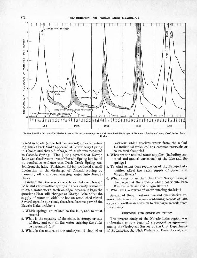
flow in the upper Sevier River. For the years of avail able record, the combined annual flow from these springs has ranged from 49 percent (in 1955) to 65 percent (in 1957) of the annual runoff of Sevier River at Hatch. (See fig. 3.)
Coal Creek, a tributary of the Escalante Valley in the Great Basin, drains the steep slopes extending westward from Cedar Breaks, and its drainage basin lies immediately west of the basins of Duck Creek and Mammoth Creek. At its nearest approach, the Coal Creek basin is 4 miles northwest from the Navajo Lake basin. Thus, Navajo Lake, whose entire outflow disappears underground, is nestled between the head waters of several streams that flow into arid and semi- arid regions where water is in great demand for irriga tion of land and for municipal and domestic use. In particular, Cedar City in the Coal Creek basin, the largest city in southern Utah and only 25 miles from Navajo Lake, has long been interested in the lake as a possible source of municipal supply.
DEVELOPMENT OF THE NAVAJO LAKE PROBLEM
Over the years, there have 'been several proposals for development and use of the water of Navajo Lake. In 1919 a preliminary survey was made to determine the feasibility of diverting water from the lake to Cedar City 'by means of a dam, tunnels, canals, and the Coal Creek channel; the cost of the project was deemed pro hibitive at that time. In 1922 it was proposed that a plug be placed in Cascade Cave, from which Cascade Spring emerges, to force that supply to the Sevier River drainage. Prior to 1933, a dike was constructed 6 feet high to separate the western three-fourths of the lakebed from the sinkholes in the eastern part, thus creating a permanent lake for fishing and other recre ation. The height of the dike was increased in 1939 and again in 1945 to a total height of about 17 feet when a gated 24-inch pipe was installed beneath the spillway to regulate the storage of some 1,300 acre-feet of water. That quantity can be retained in the lake or released to the Navajo Sinks as desired.
Each development or proposal for development of the lake water led to controversies and generally to objec tions by those who had established rights to water in the adjoining drainage basins. The controversies arose because of varying opinions and doubts concerning the relation of Navajo Lake to springs contributing water to adjoining streams. To answer some of the more common questions, several reconnaissance investiga tions were made relative to the waters of the lake, but the resulting reports have generally been inconclusive and in some instances in disagreement. Stubbins (1922) reported, on the 'basis of several tests, that dye
C4 CONTRIBUTIONS TO STREAM-BASIN HYDROLOGY
Asay Creek below/«4_ower Asay Spring
Duck Creek below DuckiCreek Spring
FIGURE 3. Monthly runoff of Sevler River at Hatch, and comparison with combined discharges of Mammoth Spring and Asay Creek below AsaySpring.
placed in 46 cfs (cubic feet per second) of water enter ing Duck Creek Sinks appeared at Lower Asay Spring in 4 hours and that a discharge of 30 cfs was measured at Cascade Spring. Fife (1924) agreed that Navajo Lake was the direct source of Cascade Spring but found no conclusive evidence that Duck Creek Spring was fed from the lake. Parkinson (1934) produced a small fluctuation in the discharge of Cascade Spring by damming off and then releasing water into Navajo Sinks.
Finding that there is some relation between Navajo Lake and various other springs in the vicinity is enough to set a water user's teeth on edge, because it begs the question: How will changes at Navajo Lake affect the supply of water to which he has an established right? Several specific questions, therefore, become part of the Navajo Lake problem:
1. Which springs are related to the lake, and to what extent?
2. What is the capacity of the sinks, in storage or rate of flow, and can all the water entering the sinks be accounted for?
3. What is the nature of the underground channel or
reservoir which receives water from the sinks? Do individual sinks lead to a common reservoir, or to isolated channels ?
4. What are the natural water supplies (including sea sonal and annual variations) at the lake and the springs?
5. To what extent does regulation of the Navajo Lake outflow affect the water supply of Sevier and Virgin Kivers?
6. What water, other than that from Navajo Lake, is discharged at the springs which contribute base flow to the Sevier and Virgin Rivers ?
7. What are the sources of water entering the lake?
Several of these questions demand quantitative an swers, which in turn require continuing records of lake stage and outflow in addition to discharge records from the springs.
PUKPOSE AND SCOPE OF STUDY
The present study of the Navajo Lake region was undertaken on the basis of a cooperative agreement among the Geological Survey of the U.S. Department of the Interior, the Utah Water and Power Board, and
TABLE 1. Primary gaging stations in Navajo Lake region
Station
Sevier River at Hatch. __
North Fork Virgin River near Springdale _
Coal Creek near Cedar City________. ________
Altitude (feet
above mean sea
level)
6,870
3,970
6,220
Drainage area
(square miles)
340
350
80. 9
Period of record
1911-28, 1939-59
1925-59
1935-37, 1938-59
Mean dis
charge (cfs)
136
102
31.4
HYDROLOGY AND HYDROGEOLOGY OF NAVAJO LAKE, KANE COUNTY, UTAH
the Cedar City Corp., which states the purpose to be "investigation of the source and disposition of the waters of Navajo Lake."
Although the investigation was concerned primarily with the waters entering and leaving Navajo Lake and with several specific questions concerning those waters, it was necessary to go rather far afield to find the an swers to some questions, and hence the studies embrace an area far larger than that immediately surrounding Navajo Lake.
The investigation was undertaken jointly by the Salt Lake City district offices of the Surface Water Branch, Ground Water Branch, and Quality of Water Branch, all in the Water Resources Division of the U.S. Geolog ical Survey. Fieldwork began in October 1953 with a reconnaissance survey by M. T. Wilson, district engi neer, and H. A. Waite, district geologist. Eecording gages were installed on Navajo Lake and at several springs and creeks during the fall of 1953 and the sum mer of 1954; most of these were continued in operation until the spring of 1959. During the summers of 1954 and 1955, several detailed tests were made to determine the effect of releasing water into the Navajo Sinks sepa rately and collectively and also into the Duck Creek Sinks. In conjunction with these tests, sodium fluores- cein, a harmless chemical dye, was used as a water- coloring trace to record time of travel. Samples of water were also collected at selected locations for chemi cal analysis to determine the quality and character istics of the water at those sites. Detailed tests during the summer of 1954 were made by D. L. Hill and those during the summer of 195'5 by A. V. Maxwell, both hydraulic engineers with the Geological Survey. Field studies of the geology of the area were undertaken by H. E. Thomas during August 1954 and August 1955.
C5
HYDROLOGY
The hydrologic studies of the Navajo Lake region were based upon: (1) records from a network of gaging stations installed especially for the project, (2) records of stage and contents of the lake, (3) special tests con ducted at the Navajo Sinks and Duck Creek Sinks, (4) water-quality data, and (5) streamflow records from regular gaging stations in adjoining drainage basins.
STREAM-GAGING STATIONS
Runoff for a relatively long period of time from the Navajo Lake region is included in the water measured at the following gaging stations, which are part of the Utah network operated by the Geological Survey in co operation with the Utah State Engineer.
729-807 O 64 2
Runoff from these primary gaging stations is only slightly affected by activities of man and therefore shows natural water yield from the drainage basins. The drainage area and the volume of runoff, however, are so great that any contributions from Navajo Lake have long since lost their identity. In the present study, the principal value of these stations has been that their long records serve to indicate the frequency of the con ditions found during the 5 years 1954-58. (See p. Cll.)
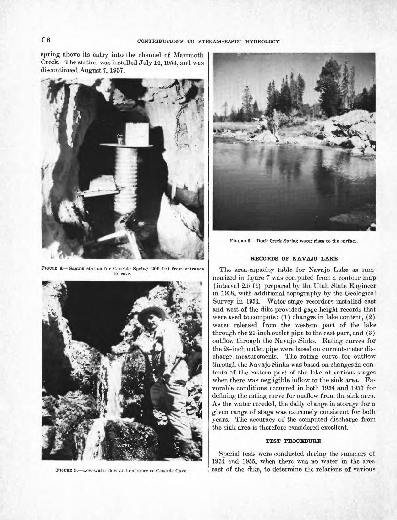
The Cascade Spring gaging station was installed within the cavern formed by the spring water, about 200 feet from the orifice (see figs. 4 and 5). It was in operation July 12, 1954, to March 31, 1959. The Duck Creek gaging station was operated from November 12, 1953, to March 21,1959. It was located just east (down stream) from the spring pond and thus measured the outflow from Duck Creek Spring (fig. 6) plus ephemeral surface runoff into this pond, from tributaries that drain Long, Midway, and Sage Valleys and Deer Hol low. In order to measure this ephemeral runoff, a gag ing station was installed in October 1957 on Midway Creek where it crosses the highway about 2 miles up stream from Duck Creek Spring. Runoff at this loca tion has been as follows: 1958, 16 days (May 29-June 13), 1,440 acre-feet; 1959, 5 days (May 11-15), 85 acre- feet; 1960, 9 days (May 11-19), 336 acre-feet. Water from Midway Creek near this location could be diverted by construction of a short feeder canal (about 1,500 ft) to Navajo Lake.
The Asay Creek gaging station was installed about a mile downstream from Lower Asay Spring and 2 miles upstream from West Asay Creek. Streamflow at this location includes discharge from Upper Asay Spring, Lower Asay Spring, and ephemeral flow from the drainage basin above. Although the drainage area above the gaging station is about 105 square miles, the creek channel above the springs is dry most of the time. The station was operated from July 13, 1954, to Jan uary 24, 1959.
The Mammoth Spring gaging station 9 miles north east of Navajo Lake measured the discharge of that
C6 CONTRIBUTIONS TO STREAM-BASIN HYDROLOGY
spring above its entry into the channel of Mammoth Creek. The station was installed July 14,1954, and was discontinued August 7,1957.
FIGURE 4. Gaging station for Cascade Spring, 200 feet from entranceto cave.
FIGURE 5. Low-water flow and entrance to Cascade Cave.
FIGURE 6. Duck Creek Spring water rises to the surface.
RECORDS OF NAVAJO LAKE
The area-capacity table for Navajo Lake as sum marized in figure 7 was computed from a contour map (interval 2.5 ft) prepared by the Utah State Engineer in 1938, with additional topography by the Geological Survey in 1954. Water-stage recorders installed east and west of the dike provided gage-height records that were used to compute: (1) changes in lake content, (2) water released from the western part of the lake through the 24-inch outlet pipe to the east part, and (3) outflow through the Navajo Sinks. Rating curves for the 24-inch outlet pipe were based on current-meter dis charge measurements. The rating curve for outflow through the Navajo Sinks was based on changes in con tents of the eastern part of the lake at various stages when there was negligible inflow to the sink area. Fa vorable conditions occurred in both 1954 and 1957 for defining the rating curve for outflow from the sink area. As the water receded, the daily change in storage for a given range of stage was extremely consistent for both years. The accuracy of the computed discharge from the sink area is therefore considered excellent.
TEST PROCEDURE
Special tests were conducted during the summers of 1954 and 1955, when there was no water in the area east of the dike, to determine the relations of various

HYDROLOGY AND HYDROGEOLOGY OF NAVAJO LAKE, KANE COUNTY, UTAH C7
25 GH 24.95 = maximum stage
USABLE STORAGE (acre-ft)
9479 -8758"
WATER-SURFACE AREA (acres)
728715
704
692
679
667
654
642
629
615
*434
*425-
*417
*407
RATE OF FLOW INTO
NAVAJO SINKS -
15
observed during 1954-58 (June 24, 1958); near highest shoreline of lake
Top of dike-GH 17.0 Crest of spillway-GH 16.0
*?/////////////////////////////&
1766
8048
7351
6665599253314683
4048
Bottom of culvert GH 12.84
Dead storage (Permanent lake west of dike)
-5
= 9021.20 ft above mean sea level, USGS datum
1660
1429 1324-
1163 1008 860
719 586 463 352 255 173 107
60 32
20
12 8
*Above dike
Flow through culvert atGH 14.9= 10.5 cfs
Ephemeral lake east of -dike (filled by overflow from west side and by springs east of dike; drained by sinks)
SINKS-£#
(cfs)
30
29
28
27
25.8
24.8
23.8
22.7
21.7 20.7-
19.6 18.6 17.6 16.5 15.5 14.5
13.4 12.4 11.4
10.3 9.3 8.3 7.2
6.2
5.2 4.1
3.1 2.1 1.0
0
FIGURE 7. -Hydraulic characteristics of Navajo Lake.
springs to the Navajo Sinks and to the Duck Creek Sinks. The test procedure included the release of meas ured rates of discharge from the storage areas to the sinks and observation of the effects of these releases upon the discharge of the several springs.
NAVAJO SINES
Water-supply conditions in 1954 were very favorable for accomplishing several of the detailed tests. The runoff was low enough that the sink area was not cov ered by water during the test period but sufficient to allow for additional storage above the spillway crest in order to make it possible to release flows large enough to test the intake capacity of the sink area. The total water released to the sinks during four tests in 1954 amounted to about 650 acre-feet. The operations are listed in chronological order:
June 8. When the lake level was high enough to cause discharge over the spillway and snowmelt runoff was receding, flashboards were installed in the spillway
and the lake level rose to approximately the top of the dike (fig. 8); temporarily increasing storage in the west part of the lake about 450 acre-feet.
July 21. The water over the sink area had been com pletely drained by the sinks and there was no surface or spring inflow to the sink area.
First test, August Z-7
August 2. Water was released to sinks beginning at 3:10 p.m.; maximum rate, 28 cfs.
August 3-6. Release was regulated to maintain con stant head of 8 feet on sinks (gage height, 3.07 ft); rate of release required, 10.4 cfs.
August 7. Release shut off at 10:20 a.m. Sink area then drained dry.
Second test, August 12-17
August 12. Water was again released to the sink area. At 8:20 a.m., 0.5 pound of sodium fluorescein dye was added when 3.2 cfs of water was entering sink 1
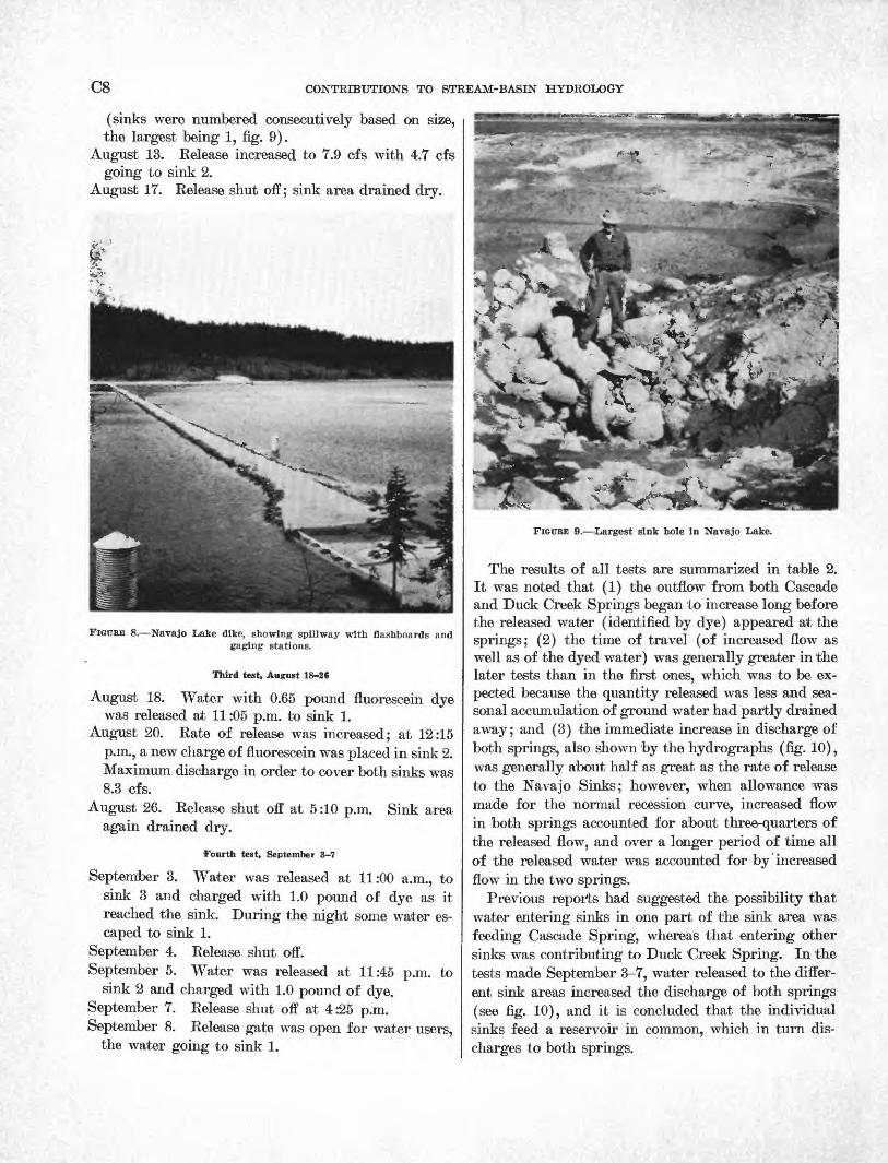
C8 CONTRIBUTIONS TO STREAM-BASIN HYDROLOGY
(sinks were numbered consecutively based on size,the largest being 1, fig. 9).
August 13. Release increased to 7.9 cfs with 4.7 cfsgoing to sink 2.
August 17. Release shut off; sink area drained dry.
FIGUEE 8. Navajo Lake dike, showing spillway with flashboards and gaging stations.
Third test, August 18-26
August 18. Water with 0.65 pound fluorescein dyewas released at 11:05 p.m. to sink 1.
August 20. Rate of release was increased; at 12:15p.m., a new charge of fluorescein was placed in sink 2.Maximum discharge in order to cover both sinks was8.3 cfs.
August 26. Release shut off at 5:10 p.m. Sink areaagain drained dry.
Fourth test, September 3-7
September 3. Water was released at 11:00 a.m., to sink 3 and charged with 1.0 pound of dye as it reached the sink. During the night some water es caped to sink 1.
September 4. Release shut off.September 5. Water was released at 11:45 p.m. to
sink 2 and charged with 1.0 pound of dye.September 7. Release shut off at 4:25 p.m.September 8. Release gate was open for water users,
the water going to sink 1.
FIGURE 9. largest sink hole In Navajo Lake.
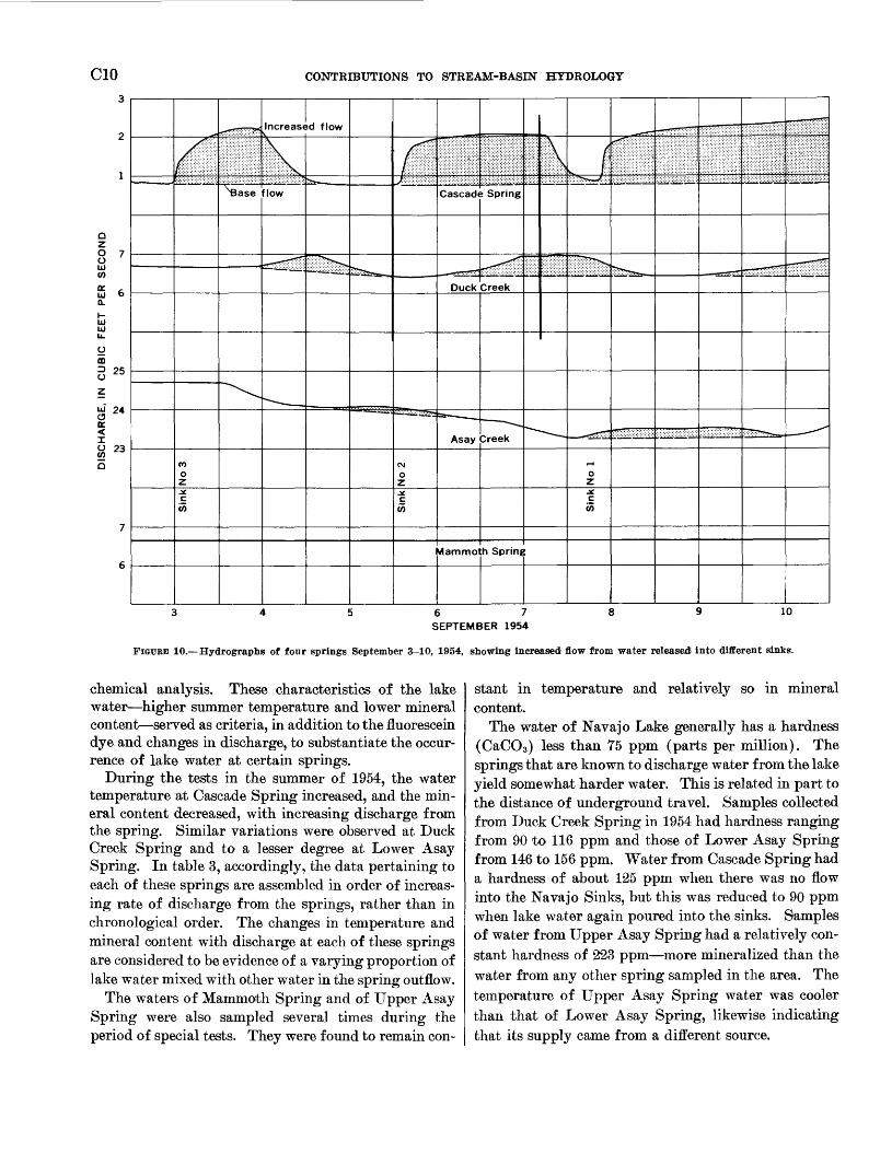
The results of all tests are summarized in table 2. It was noted that (1) the outflow from both Cascade and Duck Creek Springs began to increase long before the released water (identified by dye) appeared at the springs; (2) the time of travel (of increased flow as well as of the dyed water) was generally greater in the later tests than in the first ones, which was to be ex pected because the quantity released was less and sea sonal accumulation of ground water had partly drained away; and (3) the immediate increase in discharge of both springs, also shown by the hydrographs (fig. 10), was generally about half as great as the rate of release to the Navajo Sinks; however, when allowance was made for the normal recession curve, increased flow in both springs accounted for about three-quarters of the released flow, and over a longer period of time all of the released water was accounted for by increased flow in the two springs.
Previous reports had suggested the possibility that water entering sinks in one part of the sink area was feeding Cascade Spring, whereas that entering other sinks was contributing to Duck Creek Spring. In the tests made September 3-7, water released to the differ ent sink areas increased the discharge of both springs (see fig. 10), and it is concluded that the individual sinks feed a reservoir in common, which in turn dis charges to both springs.

HYDROLOGY AND HYDROGEOLOGY OF NAVAJO LAKE, KANE COUNTY, UTAH C9
TABLE 2. Observed flow from Navajo Sinks to various springs
A. Time of travel
Navajo Sinks
Date of test
1954
Aug. 2-7 _ _._ ____ . _ _ ___ _ __________Aug. 12-17_______---.-_.___________.__._.Aug. 18-26--_--_-__- __ _______ ________
Do----.___. __..._.__-__.__.________.Sept. 3-4_ __ ___ ______ .__ _ ____ ____Sept. 5-7_______ _________ ___ _ _____Sept. 8_ __ ._ .__ __ ___ _____ ___ ____
Sink
All 1,2
1 2 3 2 1
Cascade Spring
Time lapse, hours
Until spring flow increased
1.0 1.0 1.0
1.7 2.0 1.9
Until dye appeared
O8.5 9.5 9.8
12.5 19.0
(l)
Duck Creek Spring
Time lapse, hours
Until spring flow increased
12
12 15 18
Until dye appeared
53 53 53
Lower Asay Spring
Time lapse, hours
Until spring flow increased
32
40 40 50 52
B. Inflow vs. outflow
Navajo Sinks
Date of test
1954
Aug. 2-7___. _____________________________Aug. 12-17.... ____.__.__._.__.__._._._..
Do____ ______________________________Aug. 18-26...- _ _ _ _ __ . ____ _ _____Sept. 3-4__._ _ __. ... ______ _ __ ...Sept. 5-7.. ______________________________
1955
June 17____. ________ ___________ _______
Sink
All 1
2 1,2
3 2
All
Inflow (cfs)
10.4 3.21
7.9 47j 8.3 3.4 3.4
10.0
Increase in outflow, from recession curve
Cascade Spring
Cfs
2.8
2.1
2.5 1.4 1.5
2.5
Percent
27
27
30 41 44
25
Duck Creek Spring
Cfs
5.0
3.4
44
3.8
Percent
48
43
53
38
Lower Asay Spring
Cfs
3.0
2.0
3.0
3.0
i Test made without dye.
DUCK CREEK SINKS
Two small ponds have been developed by the U.S. Forest Service for recreation along Duck Creek Duck Creek pond at the spring and Aspen Mirror Lake about iy2 miles downstream. For the test of Duck Creek Sinks, dikes were placed in the overflow outlets which raised the water level about 1 foot in each pond. Stor age of this extra water, estimated at 12 acre-feet, began August 18, 1954; the effect at the Duck Creek gaging station (below the Duck Creek pond) was an immediate reduction of flow from 9 cfs to less than 2 cfs and subse quent recovery to 9 cfs within 54 hours. The flow of Asay Creek began to diminish 8 hours after the begin ning of impoundment of the extra water and decreased about 3 cfs before starting to recover.
On August 24, the extra water was released from Duck Creek pond, and as that water reached Aspen Mirror Lake, the water impounded there was also re leased. This water reached Duck Creek Sinks at 3:40 p.m. The discharge of Asay Creek began to increase 9
hours later. As the extra water reached Duck Creek Sinks, 1% pounds of dissolved fluorescein dye was poured into the sinks. The dye first appeared in Lower Asay Spring about noon of August 28 (a travel time of 68 hr) and the spring was markedly colored the next day; however, there was no evidence of dye in the Upper Asay Spring or in the springs along West Fork Asay Creek. It is concluded that the increased flow of Asay Creek resulted entirely from increased discharge from the Lower Asay Spring; however, the Duck Creek Sinks are not the sole source of water in the Lower Asay Spring, for the latter had a discharge five times as great as the inflow to Duck Creek Sinks just prior to the arrival of the extra water.
WATER QUALITY
The water of Navajo Lake has a markedly higher summer temperature and generally contains less dis solved mineral matter than water issuing from the springs at lower elevations which were sampled for
CIO CONTRIBUTIONS TO STREAM-BASIN HYDROLOGY
Increased flow
flow Cascade Spring
S 24a:
23
Duck Creek
Asay ^reek
V)
id am mo h Spring
6 7 SEPTEMBER 1954
10
FIGUKE 10. Hydrographs of four springs September 3-10, 1954, showing increased flow from water released Into different sinks.
chemical analysis. These characteristics of the lake water higher summer temperature and lower mineral content served as criteria, in addition to the fluorescein dye and changes in discharge, to substantiate the occur rence of lake water at certain springs.
During the tests in the summer of 1954, the water temperature at Cascade Spring increased, and the min eral content decreased, with increasing discharge from the spring. Similar variations were observed at Duck Creek Spring and to a lesser degree at Lower Asay Spring. In table 3, accordingly, the data pertaining to each of these springs are assembled in order of increas ing rate of discharge from the springs, rather than in chronological order. The changes in temperature and mineral content with discharge at each of these springs are considered to be evidence of a varying proportion of lake water mixed with other water in the spring outflow.
The waters of Mammoth Spring and of Upper Asay Spring were also sampled several times during the period of special tests. They were found to remain con
stant in temperature and relatively so in mineral content.
The water of Navajo Lake generally has a hardness (CaCO3 ) less than 75 ppm (parts per million). The springs that are known to discharge water from the lake yield somewhat harder water. This is related in part to the distance of underground travel. Samples collected from Duck Creek Spring in 1954 had hardness ranging from 90 to 116 ppm and those of Lower Asay Spring from 146 to 156 ppm. Water from Cascade Spring had a hardness of about 125 ppm when there was no flow into the Navajo Sinks, but this was reduced to 90 ppm when lake water again poured into the sinks. Samples of water from Upper Asay Spring had a relatively con stant hardness of 223 ppm more mineralized than the water from any other spring sampled in the area. The temperature of Upper Asay Spring water was cooler than that of Lower Asay Spring, likewise indicating that its supply came from a different source.

HYDROLOGY AND HYDROGEOLOGY OF NAVAJO LAKE, KANE COUNTY, UTAH
TABLE 3. Partial chemical analyses, in parts per million, of waters from Navajo Lake and from selected springs
Cll
Date sampled (1954) Discharge (cfe)
Temperature (°F) Bicarbonate (HC03)
Sulfate (S04)
Hardness as CaCOs
Specificconductance (micromhos
at 25°C)
Navajo Lake
Navajo Lake surface 1 . _____ ____Navajo Lake outflow 2 ______
July 14_________Aug. 2_________
7370
8760 3. 1
6951
139100
Springs fed in part from Navajo Lake
Cascade Spring __ _______ __. ___ ___Do _ ___________________________Do_. ____________________________Do.__. __________________________Do_. ___--_-____-__-_-_--__._____Do.___-_-_-___________._________
Duck Creek Spring. ____ _____ ______Do _ _-----__-_-______-_._______Do___. __________________________Do___ __________________________
Do___________________.__________Do... _--__-_____--__-_._________
Aug. 2_________Aug. 12________Aug. 19____ _ _Aug. 13___ _ _
July 16_._______Aug. 21__ __ _Aug. 2 _____ _
July 16 ________Aug. 3__ _ _ ___Aug. !!________July 13. _ -----
1.62.22.42.63.65.4Q 39 Q
1216282935
4749
515254
454550505051
155147136113108124128145115130193182182
6.44.95.43. 16. 9
3.74. 16.6
11.03.6
1281221119289
10010411690
104156146149
242234214180171194203226181207294280282
Springs independent of Navajo Lake
Upper Asay Spring. ______ _ ____Do______-___-___. _______________Do_. ______-_....__..--____._____
Mammoth Spring. _ ________Do. _ __________________________
July 13 _--_-_Aug. 3 __-Aug. !!________July 14_________Aug. 6_________
4747474040
271271259
9292
7.44.0
3.6
221224223
7070
410408406152152
1 Average of five samples collected from various parts of lake. * Water released at beginning of first special test (p. C7).
VARIATIONS OBSERVED IN 1954^58 AND FREQUENCY OF OCCURRENCE OF HIGH AND LOW YEARS
Water year1954 __.1955 __.1956 _.
Acre-feet 3,700
630 550
1957 ________________________ 5, 9301958 ________________________ 11, 710
The years of special study included 1 year (1954) when the lake did not overtop the dike, although it was above spillway crest for more than 2 months; 2 years (1955, 1956) when the lake level was at all times below the spillway crest; and 1 year (1958) when the lake level was above the dike for 5 months and reached a maxi mum about 8 feet over the dike. These variations are reflected in the fluctuations in annual water supply, as tabulated above, which indicate 20 times more water in the wettest year (1958) than in the driest year (1956).
Records of lake level are not available prior to Octo ber 1953. The lake is reported to have risen above the top of the dike in several earlier years, but the maximum level and length of time that the dike was overtopped are not known; however, maximum stage of the lake during 1958 was very near the highest water contour preserved on the shores of the lake from previous high- water years.
In the 25-year (1935-59) records obtained at the Cedar Breaks (12M1) and Duck Creek (12M4) snow courses, 1954 was the median year as to water content of snow on April 1. There were 3 years (1952,1945,1937) when snow exceeded that in 1958, and 5 years (1959, 1953, 1951, 1946, 1940) when the snow at these courses was less than in 1956. Thus the 5-year period appears to be fairly representative of the variety of conditions re corded during the past quarter of a century, so far as snow is concerned.
The drainage basins above three gaging stations namely, Sevier River at Hatch, North Fork Virgin River near Springdale, and Coal Creek near Cedar City practically surround the Navajo Lake drainage basin. Concurrent runoff records have been collected on these three streams since 1940. Percentage varia tions from year to year in the annual yield are very consistent, largely because their headwaters are in the same general area (Gatewood and others, 1964). (See fig. 11.) During the 1954-58 period, runoff was about 60 percent of the 21-year mean in 2 years, about 85 percent in 2 years, and about 160 percent of the mean in 1958. The surface-water supply for Navajo Lake was far more variable in these same years, ranging from 14 percent of the computed 21-year average in 1955

C12 CONTRIBUTIONS TO STREAM-BASIN HYDROLOGY
and 1956, to 283 percent in 1958. These large variations in surface-water supply at Navajo Lake result from the fact that only part of the total supply appears at the surface and this part is a residue after filling of the ground-water channels or aquifers, the capacity of which approaches a constant. A relatively constant ground-water flow continues below the altitude of Navajo Lake and is a part of the supply feeding springs below. Viewed separately, therefore, Navajo Lake is very unreliable on the basis of a year-to-year require ment, and unusually large holdover storage would be needed to equalize the extreme variations in the annual supply.
300
1954 1955 1956 1957 1958
VARIATIONS IN RUNOFF
1959 1960
FIGURE 11. Variations In runoff, showing large variations In Navajo Lake water supply compared to runoff from adjacent streams.
Streamflow records since 1912 in the plateau region that includes Navajo Lake show that high-water years similar to or greater than 1958 recur on an average of one in 3 years. They also show that low-water years comparable to 1955 and 1956 will likely recur on an average of once in 8 years. It is not uncommon, how ever, for low-water years, such as 1955 and 1956, and high-water years like 1920, 1921, 1922, and 1923, to occur consecutively.
CONCLUSIONS BASED ON DATA COLLECTED IN 1954-58
RELATION OF NAVAJO LAKE TO CASCADE AND DUCK CREEK SPRINGS
1. Water discharged from Navajo Lake into the Navajo Sinks flows to Cascade Spring and also to Duck Creek 'Spring. This is shown by changes in quantity, temperature, and quality of the
spring waters resulting from releases into the sinks. Additional proof is the appearance of dye at both springs after introduction into the sinks. The flow to Duck Creek Spring was also confirmed in October 1954 when fish were killed there by the introduction of rotenone into Navajo Lake to destroy the trash fish. Water from Cas cade Spring is tributary to the Virgin River; that from Duck Creek Spring continues via Duck Creek, Duck Creek Sinks, Lower Asay Spring, and Asay Creek to the Sevier River. Thus the major divide between the Great Basin and the Colorado River basin cuts through the waters discharged from Navajo Lake.
2. Cascade Spring is 160 feet lower than and about 6,400 feet south of the Navajo Sinks; thus the average gradient for subterranean flow is 2^ percent. Duck Creek Spring is about 475 feet lower than and 18,500 feet east of the Navajo Sinks, giving likewise a gradient of 2^ percent. The observed rates of travel of fluorescein dye from Navajo Sinks to Cascade Spring ranged from 5.6 to 12.5 fpm (feet per minute); the velocity to Duck Creek Spring was 5.8 fpm.
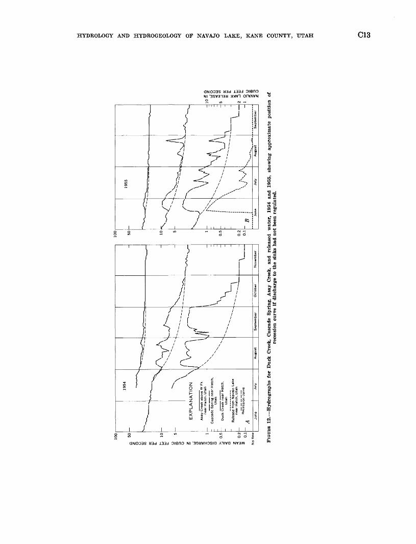
3. Practically all the water that enters Navajo Sinks reappears eventually either at Cascade Spring or Duck Creek Spring, although the observed coin cident increase in spring flow was only about half the rate of intake by the sinks. During 'both 1954, when detailed tests were in progress, and 1955 when measured water was released to the sink area, all water entering the sinks could be accounted for by the measured discharge from the two springs when sufficient time was allowed to drain the excess storage from the ground- water aquifer. Computations of the volume of water represented between normal recession curves and hydrographs for the two springs ac counts for more than 95 percent of the released water. (See fig. 12.)
4. During tests when water was released to specific individual sinks, the immediate increase at Cas cade and Duck Creek Springs varied. These variations are believed to reflect the localized var iations in storage and reservoir space under ground at the times of releases. Significantly, the records show that all the sinks are connected with both Cascade and Duck Creek Springs. Thus the water entering Navajo Sinks appar ently reaches an interconnected underground res ervoir and channel system.
5. The apportionment of the water entering Navajo Sinks is approximately 40 percent to Cascade
3
q
z MEAN
DAILY
DISCHARGE,
IN
CUBIC
FEET
PER
SECOND
3
?
o
o
p _ ui o cjSn-
ro 01 »- mo
oo
EX
PL
AT
19
54
\
\vlA
TIO
N \
Asa
y C
reek
abo
ve W
Fk
near
Ha
tch
, U
tah
Cas
cade
Spring n
ear
Ha
tch
, ~
Uta
h
~
Duc
k C
reek
nea
r H
atch
, U
tah
Rel
ease
fro
m N
avaj
o La
ke
near
Ha
tch
, U
tah
Rec
essi
on c
urv
e~
A
June
Ju
ly
^"^^
^^srT
^
<\A
^ \
\ v
N N
X
August
f1
\
-
-^
\
No
vem
be
r
100
50 10
5 1
0.5
0.2
0.1
"^~
^~^
-r^~
^
^ c
^
- ~ B
June
1955
;\
Ju
ly
^J\
'
^
>-SN
August
-x^ \ _
Se
pte
mb
er
DROLOGY
AND
HYDROGEOLOGY
OF
NAVAJO
LAKE, KAN
QNO03S «3d
133d OianO
Nl
'3SV3n3« 3W1
OPVAVN
o S
m cy -<
W
BE
12. -H
ydro
gra
phs
for
Duck
Cre
ek,
Cas
cade
S
prin
g,
Asa
y C
reek
, a
nd
re
leas
ed
wate
r,
1954
a
nd
19
55,
sho
win
g
appro
xim
ate
p
osi
tion
o
f O
re
cess
ion
curv
e if
dis
charg
e t
o t
he
gin
ks h
ad n
ot
been
regula
ted.
2 !2j a O I »
G
O
C14 CONTRIBUTIONS TO STREAM-BASIN HYDROLOGY
Spring and 60 percent to Duck Creek Spring, as shown in the test of August 2-7 when all the sinks were covered by water and also in the hydrograph for both years 1954 and 1955 (fig. 12). When increased flow to the sink area is of short duration, such as July 15-17 and 24-27,1955 (fig. 12B), the difference in time of travel from the sink area to the respective springs and the nor mal recession curves must be considered when evaluating the amount of increased flow for each spring. When these adjustments are made, the apportionment of increase is consistent with that shown for longer periods of time. The discharge of both Cascade Spring and Duck Creek Spring increased considerably more than the release to the sink area for the periods August 11-20 and 24-30, 1955. This increased flow was caused by precipitation in the basin and shows that both springs receive water from other sources than Navajo Sinks. This subject is discussed further under the heading, "Other sources of water in major springs." Precipitation at Cedar Breaks during August 9-18 was 3.07 inches and August 22-25, 2.61 inches. During high-water years when there were several months of continuous flow into the Navajo Sinks and when there was little or no contribution directly from rainfall or snowmelt, the proportional discharge of Cascade Spring was as follows: July-September 1957, 43 percent; June-September 1958, 40 percent.
6. Regulation of outflow from Navajo Lake by exist ing structures, which provide for release of con trolled storage water to the sink area during the irrigation season, does not materially change the proportions of water going to Cascade and Duck Creek Springs; however, the seasonal distribu tion can be changed by the amount of controlled storage water (1,378 acre-ft) between the spill way crest and the outlet pipe. If the dike is raised in the future to a higher elevation to pro vide additional controlled storage, the seasonal distribution could be changed materially.
OTHER SOURCES OP WATER IN MAJOR SPRINGS
7. Cascade Spring receives water other than that flow ing to it from the Navajo Sinks. After cessation of flow from the lake into the sinks, Cascade Spring has continued to flow for periods of 95-125 days at a rate of less than 3 cfs in the first month and less than 1 cfs in subsequent months a small increment that is probably derived by seepage from the lake and from the ridge that intervenes
between lake and spring. Cascade Spring was dry for periods of 50-160 days in each of the win ters of 1955-57. Cascade Spring also receives water directly from snowmelt and from rain upon the ridge separating it from Navajo Lake. The peak discharge in both 1957 and 1958 occurred 15-30 days before Navajo Lake reached its maxi mum stage but at the time of maximum melting of snow. At other times also the spring discharge has increased during periods of snowmelt or rain storms, and the contemporaneous rise in lake level was insufficient to account for the discharge as originating from the sinks alone.
8. Duck Creek Spring, likewise, receives water from other sources than Navajo Sinks. This is shown when the sinks receive no water for extended periods, yet the spring discharge does not decline below about 0.5 cfs. Records also show that in each year the maximum monthly discharge of Duck Creek Spring has exceeded the total amount of water entering the Navajo Sinks during that month. The surface drainage area above Duck Creek Spring is six times as large as that tribu tary to the Navajo Sinks.
9. The water issuing from Duck Creek Spring flows eastward about 21^ miles and then enters the Duck Creek Sinks, which have adequate intake capacity for the greatest flow (226 cfs) ever measured in Duck Creek. Since 1954 the dis charge of Asay Creek below Lower Asay Spring has ranged from 13 cfs, when the entire flow was from Upper and Lower Asay Springs, to 419 cfs, which included overland runoff from melting, snow. Although the water entering the Duck Creek Sinks contributes to the water of Lower Asay Spring, it is not the only water discharged by that spring.
Upper Asay Spring is about 2,000 feet up stream from and 25 feet higher than Lower Asay Spring. Its flow is less than one-fourth (18 per cent during the fall of 1953) of the flow of Lower Asay Spring and was not seen to be affected by the artificial release of water or of fluorescein into the Duck Creek Sinks.
10. Mammoth Spring is 10 miles northeast of Navajo Lake and separated therefrom by a major topo graphic divide; its orifice is about 900 feet lower than the Navajo Sinks. The artificial release of water and of dye into the Navajo Sinks and Duck Creek Sinks had no observed effect upon the water discharged at Mammoth Spring. The discharge of Mammoth Spring is ordinarily more than

HYDROLOGY AND HYDROGEOLOGY OF NAVAJO LAKE, KANE COUNTY, UTAH C15
twice that of Duck Creek Spring. The hydro- graphs for the two springs are quite similar in general trend^ doubtless reflecting the similarities of snow runoff and rain runoff for the general area. In detail, however, there are marked dif ferences, especially when Navajo Lake levels re main higher than the cutoff dike throughout the summer and fall. At such times the flow of Duck Creek Spring is well sustained and temporarily exceeds that of Mammoth Spring.
WATER REGIMEN AND SUPPLY OF NAVAJO LAKE
11. The computed water supply for Navajo Lake shown on page Cll (550 acre-ft in 1956, 630 in 1955, 3,700 in 1954, 5,930 in 1957, and 11,710 in 1958) did not include quite all the water that enters or leaves the lake area. During the late fall and winter, when evaporation may be pre sumed to be minimal, when several small peren nial springs continue to flow into the lake, and when there is no discharge to the east part, the lake level west of the dike was observed to decline at a rate of 0.02 foot per day, indicating a net depletion of about 4 or 5 cf s. The water thus lost may reappear, at least in part, at several springs which rise west of and at levels comparable to Cascade Spring but south of the western part of the lake.
12. During 1958, the inflow to Navajo Lake was about 12,000 acre-feet, or 3.0 acre-feet per acre of the 4,000-acre drainage basin that is topographically tributary to the lake. As of April 1 of that year, the water content at the Midway Valley (12M2) snow course (alt 9,400 ft) was 31.5 inches, and at the Duck Creek (12M4) snow course (alt 8,560 ft) 18.7 inches. Assuming that the mean of these two snow courses is representative of Navajo Lake basin, the snow storage, equivalent to 2.1 acre-feet of water per acre, indicates a water supply of about 8,000 acre-feet within the Navajo Lake drainage basin. Thus the inflow to the lake was 50 percent greater than could have been obtained from all the snow within the drainage basin.
13. Evidence that Navajo Lake receives water by under ground flow from beyond the limits of its drain age basin is forthcoming from statements by several long-time residents of the region. Mr. Alvin Larson reports that Koaring Spring (along the north shore of Navajo Lake and several feet above normal lake level) flows only when water is entering sinks in Midway Valley and stops within 2 days after the sinks go dry. Mr. George Smith
has reported turbid flow in Koaring Spring after exceptional cloudbursts to the north. Roaring Spring was not seen to flow during the field studies by the authors.
14. The annual water supply to Navajo Lake during the period 1954-1958 ranged from 14 percent (1955, 1956) to 283 percent (1958) of the computed 21- year average. These variations reflect the varia tions in precipitation but are far greater in magnitude because the water supply to the lake represents the residue from a contributing area after deductions for evapotranspiration and for filling of ground-water reservoirs or aquifers, which probably vary only slightly from year to year. Additional developments of the surface supply would require considerable holdover stor age capacity in order to equalize the large varia tions and provide a consistent year-to-year water supply, and such a development could have a significant effect on present water rights in both the Sevier and Virgin River basins.
UNDERGROUND FACILITIES FOR STORAGE AND MOVEMENT OF WATER
15. The numerous perennial springs in the Navajo Lake region, by continuing to flow throughout rainless periods, are evidence that there is some storage of water underground. The special tests of the Navajo Sinks, during which the outflow from Cascade and Duck Creek Springs increased long before the actual arrival of water used in the tests, and the requirement that a velocity of 2 fps (feet per second) would be necessary for the short travel time between the sinks and Cascade Spring, indicate that at least some of the subterranean water is confined under pressure. These tests also indicate that there is some degree of inter connection, particularly with respect to the res ervoirs, channels, or compartments that receive water from individual sinks.
16. There is also conclusive evidence, however, that the numerous sinks and springs in the Navajo Lake region do not constitute entries and exits for a single extensive ground-water reservoir. Instead, they indicate the existence of numerous compart ments or channels that may be isolated or very in directly connected with each other. One example of such isolation is provided by the two Asay Springs, of which one is clearly connected with Duck Creek Sinks, the other completely independ ent. Another example is the spring on the ridge south of Navajo Lake (the source of water for
C16 CONTRIBUTIONS TO STREAM-BASIN HYDROLOGY
Navajo Lake Lodge) which is presumably fed by water moving northward; Cascade Spring and and several others farther west evidently derive some water by southward movement from the same ridge in addition to that from Navajo Lake.
17. At present there are no wells in the Navajo Lake region and no evidence of a saturated zone within the rocks that underlie the plateau. It is possible that test drilling would result in discovery of such a zone, but it is also possible that the prevailing circulation underground is by means of solution channels developed at random and at various levels in the limestone; the existing sinks provide one means of access to these channels, and the water is subsequently discharged at springs which may be perennial or ephemeral, depending upon the amount of underground storage and frequency of replenishment.
18. During high-water years when Navajo Sinks are covered before the maximum snow-runoff period, it is possible that the movement of water from the surface to a ground-water source is temporarily reversed. Since the lower part of the sink area is relatively near the limestone aquifer, a large supply of water from higher elevations north of the lake could develop a static head in the ground- water course greater than the depth of water in the lake over the sink area. The orifices would then act as springs to the lake supply rather than sinks.
HYDROGEOLOGY
The rocks that crop out on the Markagunt Plateau are of Cenozoic age (pi. 1), which is also the age of all geologic features that have been of significance in the development of Navajo Lake, of the sinks and springs, and of the surface channels and underground routes that characterize the present drainage pattern. The rocks of Cenozoic age, however, constitute only the upper 2,000 feet or less of the massive block that forms the plateau; beneath them are flat-lying Mesozoic rocks aggregating 6,000-10,000 feet in thickness and also a considerable but unknown thickness of Paleozoic sedi mentary rocks. These Mesozoic and Paleozoic rocks crop out in the slopes bordering the plateau of which some have been mapped recently by Cashion (1961) and Averitt (1962).
BOCKS AND THEIR WATER-BEARING PROPERTIES
The rocks of the Navajo Lake region may be conven iently considered in two broad groups rocks of the Cenozoic Era, which crop out on the Markagunt Plat eau, and the pre-Cenozoic rocks, which do not. The rocks of Cenozoic age are sufficiently important in the hydrology of Navajo Lake to be discussed as individual units.
PRE-CENOZOIC BOCKS
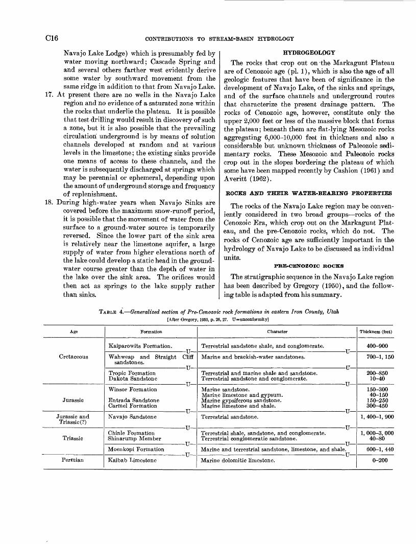
The stratigraphic sequence in the Navajo Lake region has been described by Gregory (1950), and the follow ing table is adapted from his summary.
TABLE 4. Generalized section of Pre-Cenozoic rock formations in eastern Iron County, Utah [After Gregory, 1950, p. 26, 27. U=unconformity]
Age
Cretaceous
Jurassic
Jurassic andTriassic(?)
Triassie
Permian
Formation
Kaiparowits Formation.
Wahweap and Straight sandstones.
Tropic Formation Dakota Sandstone
Winsor Formation
Entrada Sandstone Carmel Formation
Navajo Sandstone
Chinle Formation Shinarump Member
Moenkopi Formation
Kaibab Limestone
U Cliff
U
U
U
U
TT
TTU
Character
Terrestrial sandstone shale, and conglomerate.
Marine and brackish-water sandstones.
Terrestrial and marine shale and sandstone. Terrestrial sandstone and conglomerate.
Marine sandstone. Marine limestone and gypsum. Marine gypsiferous sandstone. Marine limestone and shale.
Terrestrial sandstone.
Terrestrial shale, sandstone, and conglomerate. Terrestrial conglomeratic sandstone.
Marine and terrestrial sandstone, limestone, and
Marine dolomitic limestone.
U
IT
U
U
U ,
U shale.
Thickness (feet)
400-900
700-1, 150
200-850 10-40
150-300 40-150
150-250 300-450
1, 400-1, 900
1, 000-3, 000 40-80
600-1, 440
0-200
HYDROLOGY AND HYDROGEOLOGY OF NAVAJO LAKE, KANE COUNTY, UTAH C17
As pointed out by Gregory, there is a general absence of angular discordance of bedding at unconformities; the attitude of the marine sedimentary rocks is gener ally accordant with the underlying and overlying ter restrial sedimentary rocks even where faunas and rock types indicate long time lapses and radical changes in the conditions of sedimentation.
The dominant rock type in the Mesozoic sequence is sandstone. Several of the sandstone beds are moder ately permeable, and others appear to have porous zones, although they are prevailingly massive. The cliffs, steep slopes, and canyons that extend down from the Markagunt Plateau include many places where seeps emerge from bedding planes and joints. For examples, several seeps mark places where the weakly cemented Straight Cliffs Sandstone overlies shale or coal; the springs that constitute the principal water supply for Cedar City emerge near the base of a thick Cretaceous sandstone; and springs occur also along the contact of the loosely compacted Dakota Sandstone with the under lying Winsor Formation.
Most of the water in these Mesozoic rocks has prob ably entered the permeable sandstones in their areas of outcrop west of the Markagunt Plateau and moved gen erally down dip. Although some water may move downward from the surface of the plateau through joints or faults or other permeable zones, the quantity thus involved is presumed to be small and perhaps negligible, because of the numerous shaly beds and other impermeable zones that would impede vertical move ment of water.
The most obvious role of the pre-Cenozoic rocks in the Navajo Lake region is a supporting role; the Mark agunt Plateau depends upon them for most of the alti tude required for wringing precipitation out of moisture-laden airmasses.
WASATCH FORMATION
The Wasatch Formation, of Eocene age, is separated from underlying Upper Cretaceous rocks by an erosional unconformity having an observed relief as, great as 600 feet. The following description of the Wasatch For mation is quoted from Gregory (1950, p. 61-64) :
In distant views the Wasatch formation appears as a sequence of roughly parallel beds that differ merely in thickness and color. In near views it is seen to comprise three parts, roughly defined by color and manner of erosion: a basal, generally red, unit of conglomerate and sandstone 5 to 150 feet thick; an intermediate sequence of pink limestone and calcareous shales, 500 to 900 feet thick; and a top series of white limestones.1
1 In an earlier report on the eastern Markagunt Plateau, Gregory (1949, pi. 1, p. 983-985) has mapped similar white limestones as part of the Brian Head Formation, overlying the Wasatch. The Brian Head is readily distinguishable from the Wasatch where it contains tuff and other pyroclastic materials, which are observed in outcrops in the vicin-
However, exposures along the Pink Cliffs show that these sub divisions, based on gross composition and color, have no per sistent boundaries and that within them the composition, tex ture, and continuity of beds is far from uniform. Within a half mile along strike thick, massive, nearly pure limestone may grade into thinly laminated calcareous shale or terminate in sandstone, and in places lenticular masses of conglomerate lie within the limestone several hundred feet above the base of the formation.
The basal conglomerate in the Wasateh formation consists of exotic pebbles in a matrix of calcareous sandstone or cal careous-ferruginous siltstone. In places this coarse material forms a well-defined bed, but commonly it appears as wedges and stubby lenses of closely packed pebbles about which indi vidual pebbles are sporadically distributed * * *
Of the rocks that make up the Wasatch formation, limestone is predominant. From its top to its bottom the formation is calcareous. In fact, the terms "Wasatch formation" and "Wasatch limestone" are substantially synonymous. In some cliff sections the limestone appears as undivided masses 100 feet thick and so compact, homogeneous, and fine textured as to justify the local name "pink chalk." Commonly, however, the massive beds are less than 25 feet thick and are separated from each other by thinly laminated hard pure limestone, by sheets and lenses of calcareous sandstone and shale, or by porous material that resembles travertime. In places the rock is brecciated, and includes concretions of hard limestone, iso lated pebbles of quartzite, and lenses of conglomeratic sand stone. Many of the thick beds are marked by "honeycombs," and by cavities lined with calcite crystals. On the plateau tops open cracks and sink holes lead downward to tunnels that carry underground water to the cliff faces giving rise to springs. * * *
Scores of measured sections in the Markagunt and neighbor ing plateaus substantially show that the strata that compose the Wasatch formation are about the same age and that during their deposition generally uniform conditions of sedimentation prevailed. They have always been recognized as nonmarine. Thus, in discussing sections south of Navajo Lake, Gilbert re marks: "While we are not certain that our rock series records the termination of the Cretaceous age, we do find in it a history of the local extinction of the Cretaceous marine fauna, and the substitution of a continental fauna; and it is convenient, in the present condition of our ignorance, to call this latter Tertiary." * * * The physical make-up and the Vertical and lateral distribution of beds in the Wasatch suggest deposition by streams of fluctuating volume 'streams tributary to basins of different sizes and depth, some of them overlapping, others widely separated; some fairly permanent and others filled and dried up in response to periodic rainfall.
Though beds classed as Wasatch in eastern Iron County are unquestionably of Eocene age,2 neither their fauna nor their physical features serve to place them more precisely in the time scale. That they are not the oldest Tertiary is shown by the presence among the fossils of forms reported to be "later
ity of Panguitch Lake, and in increasing proportions to northward. In the drainage basins of Mammoth Creek and Asay Creek, however, the extensive outcrops of the Brian Head as mapped by Gregory are domi- nantly white lacustrine limestone, with some claystone and sandstone. Gregory recognizes that there is "some basis for the suggestion that the Brian Head is a phase of Wasatch deposition " 'pink Wasatch' capped by 'white Wasatch.'" On the geologic map for this report (pi. 1) the Wasatch Formation includes the limestone and other nonvolcanic sedi ments that had been mapped as Brian Head by Gregory (1949). The formation as mapped may therefore include some beds younger than Eocene in age.
2 See footnote above.

CIS CONTRIBUTIONS TO STREAM-BASIN HYDROLOGY
Eocene" in age and by the evidence that erosion was in progress in the Pink Cliffs region while as much as 2,000 feet of Ter tiary strata were being laid down in other parts of Utah. Thus the great hiatus in Cretaceous-Tertiary sedimentation of the Markagunt Plateau is represented in the Wasatch Plateau by an uninterrupted sequence of late Cretaceous, Paleocene, and Eocene strata. Attempts to correlate subdivisions of the Ter tiary in the southern High Plateaus with those farther north have yielded no satisfactory results, and it seems probable that the two regions have different Cenozoic histories.
The following section is based on that measured by N. C. Williams in the Ashdown Creek drainage basin in Cedar Breaks National Monument (Gregory, 1950, p. 78).
TABLE 5. Section of Wasatch Formation, Cedar Breaks National Monument
[Adapted from N. C. Williams]Thickness
feetLimestone, white; some beds of gray calcareous sand
stone _____________________________ 190 Limestone, red to yellowish white; some shale______ 80 Shale, white, calcareous___________________ 71 Shale and marl, yellow, brown, and tan__________ 52 Shale, white, calcareous___________________ 63 Limestone, white_________________________ 23 Shale and marl, variegated, calcareous__________ 112 Limestone, red and pink; with lenses of conglomerate,
sandstone, and shale; cliff forming___________ 347 Shale, yellow, calcareous; some limestone_________ 51 Limestone, red; alternating with shale__________ 42 Limestone, red and pink; with lenses of coarse sand
stone; cliff forming______________________ 79 Limestone, red, shaly______________________ 27 Limestone, white and red, few lenses of shale 'and sand
stone _________________________ 111 Shale and clay, variegated___________________ 110 Limestone, mottled________________________ 5 Shale, red, pink, and gray__________________ 15 Limestone, white and pink___________________ 10 Clay, red, calcareous______________________ 5 Limestone, white to mottled red; cliff forming______ 44 Shale, yellow, calcareous; cliff forming__________ 12 Sandstone, red and yellow, alternating with shale; cliff
forming ____________________________ 30 Sandstone, pink, gray; cliff forming____________ 60 Sandstone, red and yellow, alternating with shale; cliff
forming _____________________________ 32 Sandstone, red; cliff forming_________________ 21 Conglomerate, sandy limestone matrix ; cliff forming__ 0-5
Total ____________________________ 1,327
SILICIC VOLCANIC BOCKS
Extrusive igneous rocks are represented in the Navajo Lake region by volcanic cones, streams of lava, and de tached sheets that have been isolated by faulting or erosion, as pointed out by Gregory (1950, p. 97-98) :
So far as determined the lavas are rhyolites and basalts two general classes distinguishable by differences in gross composi tion, texture, color, and manner of erosion. Within these classes
even superficial examination shows variations sufficient perhaps for the definition of subclasses. As recorded in the field the rhyolites are the "older lavas," and the basalts, the "younger lavas," or in Button's terminology, "Tertiary volcanics" and "Quaternary volcanics." None of the vents which gave rise to the older lavas was found. Cones that may have marked their position have been worn away, feeding dikes are not exposed, and observed variations in rock texture are not sufficiently local ized to serve as clues in defining centers of eruption. On the other hand the source of most of the younger lava is marked by volcanic cones about which are accumulated rugged masses of basalt and scoria and from which lava streams extend 1 to 3 miles * * *
All igneous rocks in eastern Iron County are of Tertiary, Quaternary, or Recent age but in the absence of stratigrapbic markers between the Wasatch formation and the glacial deposits, their position in the time scale can be fixed only by their place in the stratigraphic column, their relation to faults, and their topographic form * * *. The rhyolites, which seem to be all of the same age, pre-date the known tectonic movements of the region. They have been broken and displaced by the Hurricane fault and by the long fractures on the Piute Highlands tectonic features which record events of middle or late Tertiary and early Quaternary times. In the light of present knowledge it seems reasonable to assign the rhyolites of the Black Ledge and of Summit Ridge to Miocene time.
Gregory also pointed out that although rhyolite and rhyolitic tuff are common on the western Markagunt Plateau, the silicic volcanic rocks farther east are andesites and latites, which are prevailingly porphyritic.
Navajo Lake appears to be beyond the southern limit of distribution of these rhyolite and andesite flows and associated pyroclastic materials of probable Miocene age, which are thick and widespread farther north in central Utah. These silicic volcanic rocks, however, cover the Wasatch Formation in a few places within the Asay Creek basin and in extensive areas within the Mammoth Creek basin. Where these volcanic rocks are present, they have served to protect the underlying Wasatch Formation from the erosive and solvent action of water. The permeability of the silicic volcanic rocks is limited to that created by fractures, and the unit is far less permeable than the underlying Wasatch Formation or the overlying basalt.
BASALT
Basalt chiefly olivine basalt has been erupted from vents distributed widely over southwestern Utah, in cluding several on the Markagunt Plateau. The basal tic eruptions on this plateau all occurred after its up lift ; some lava flowed down the steep western slope, and some flowed down or blocked stream valleys on the plateau surface. Some flows were early enough to have been faulted, and some are covered with a thin mantle of soil and vegetation, but others appear to be so recent that you may step gingerly until you are sure they are cool enough to walk on. The extended period of erup-

HYDROLOGY AND HYDEOGEOLOGY OF NAVAJO LAKE, KAHE COUNTY, TJTAH C19
tions lias not been dated, but it probably began in the Pleistocene and may well have continued into the Recent Epoch.
In the region east and southeast of Cedar Breaks National Monument many of the lava flows may be traced from their source to their abrupt termination, and the cones have slopes normal lor materials accumulated about volcanic vents. Of the numerous cones some have been deeply scoured by streams, and others are little changed from their original form. Han cock Mountain, Houston Mountain, and neighboring volcanic cones on the Markagunt plateau retain their summit craters; from their sides extend streams of cellular, scoriaceous lava, marked by ropy structures, gas mounds, pressure faults, and other features characteristics of recent flows, (Gregory, 1950, p. 100).
Many of the outcrops of basalt, particularly the flows that have broken into jagged blocks, are permeable enough that they can absorb the water of maximum cloudburst storms or maximum snowmelt without run off, and the water percolates downward rapidly from the bare outcrops. In other places, vegetation has ob tained a foothold, even developed a forest cover, but the soil is capable of absorbing precipitation at high rates with negligible runoff. On the other hand, basalt flows have been sufficiently impermeable to form effec tive barriers to water movement along the pre-basalt valleys, as noted especially near the Navajo Sinks and the Duck Creek Sinks, where the drainage is now achieved by channels in the limestone beneath the basalt. These extremes serve to indicate the range of water bearing properties of the basalt layers of dense rock that are impermeable except along fractures, and some fine-textured ash beds that are likewise impermeable, but with fractures so numerous in the lava as to create high permeability, especially in broken blocks, lava tunnels, and probably in the zones of contact between individual flows.
AULT7VIT7M
The larger valleys in the region are floored by stream- borne detritus, chiefly silt, clay, and sand, some gravel and a few boulders and blocks of limestone and basalt. Similar in composition to these alluvial sediments are the deposits in closed depressions where the only drain age is underground and where ephemeral or perennial lakes may form; Navajo Lake is the largest of these. Near the edges of these lowland areas a substantial part of the unconsolidated material may be unsorted colluvium, derived by frost action, slope wash, and gravitational pull from adjacent slopes. These al luvial, colluvial, and lacustrine sediments have not been differentiated in the geologic mapping and are grouped on plate 1 as alluvium.
In the absence of wells, pits, or sumps, nothing is known of the maximum or average thickness of the al
luvium, although it is demonstrably thin at several road- ciits and gullies where the underlying bedrock is ex posed. The prevailingly fine texture of the valley fill is attributed to the fact that it is derived chiefly from the Wasatch Formation. Because of this fine texture it is presumed that the alluvium in general is relatively im permeable. The absence of wells does not constitute proof that the alluvium contains no permeable beds which could yield water sufficient at least for domestic and stock supply; however, it is presumed that here as elsewhere the ranchers have in the past dug wells in search of shallow water, but here their efforts have been generally fruitless. It is considered likely, therefore, that the underlying Wasatch Formation generally is permeable enough to drain the alluvium. The uncon solidated valley fill in the region is thus classified as dubious as a source of water.
GEOMORPHOLOGY OF THE MARKAGUNT PLATEAU
The amazing display of plateaus, terraces, cliffs, and canyons in southwestern Utah is basically the consequence of structural adjustments, simple in process; vast areas of originally flat-lying sediments and lava, uplifted and broken into tabular masses by faults, have provided favorable conditions for rapid and pro found erosion (Gregory, 1950, p. 105).
The Markagunt Plateau is one of these tabular masses with general north-south alinement; it is bounded on the east and on the west by major faults.
The Markagunt Plateau has a width of about 25 miles between Cedar Breaks and the Sevier fault. The west ern part of the plateau has been elevated about 3,000 feet higher than the eastern part, and the plateau strata now dip about iy2 ° eastward on the average. The up lift of the western part of the plateau involved move ment not only along the Black Ledge fault but also along other faults generally parallel to it and farther west, including those within the Hurricane fault zone. The faulting that elevated the Markagunt block did not begin until after the silicic volcanic eruptions, and it continued intermittently into the Pleistocene.
PATTERN OF SURFACE DRAINAGE
Practically the entire surface of the Markagunt Pla teau is drained by tributaries of the Sevier River, which flows northward along the eastern margin of the plateau block. The tributaries, flowing eastward on a gently inclined plane, have formed valleys in the rhyolitic rocks and in the underlying Wasatch Formation. Some of these valleys doubtless had their inception with the first faulting that elevated the Markagunt Plateau. The valley now occupied by Navajo Lake and a dry valley immediately south of it both appear to have been devel oped when the edge of the plateau was considerably farther south and west than it is today.
C20 CONTRIBUTIONS TO STREAM-BASIN HYDROLOGY
Although most of the surface drainage of the plateau has been developed as part of the Sevier Eiver system, the streams most active in modification of the plateau are those that rise along its west and south edges. These streams are whittling away at the area of the plateau and reducing the altitude of its highest points. The erosion by Coal Creek along the west margin of the plateau has created the spectacular Cedar Breaks, and tributaries of the Virgin River have formed cliffs of similar magnitude along the plateau's south edge. Both streams are heavily laden with sediment, particularly during summer cloudburst-type storms. The Sevier River is by no means a clear stream, but it is far less effective in erosion, chiefly because it is working under a severe handicap in gradient. It flows more than 60 miles from the plateau crest to reach an altitude 6,000 feet above sea level. By contrast, Coal Creek and the tributaries of the Virgin River flow only about 12 miles to reach the same altitude.
DISTRIBUTION OF BASALT PLOWS
Within the drainage basins of Asay and Mammoth Creeks there are 20 volcanic cones, and many of these retain their summit craters. The highest and western most of these cones reaches an altitude of 10,670 feet and projects about 500 feet above the lava plain that sur rounds it. Other cones are generally 150-500 feet high, and their summit altitudes, like the general plateau surface, are progressively lower eastward. Seventeen of these cones are located along three lines that trend generally northeastward parallel to the Black Ledge fault. Nine of the cones are along the present topographic divide between the Mammoth and Asay Creek basins, and it is likely that this divide was created in large part by the eruptions.
Flows of scoriaceous lava, from these craters and probably also from fissures whose positions are no longer apparent, form overlapping sheets that together have added 300-1,000 feet to the height of the plateau at some locations. In many places the ends and sides of individual flows are clearly discernible, and their sur faces are unmodified except for accumulation of blocks produced by frost action. Because of the meager soil development on the more recent lava flows, the outcrops are capable of rapid absorption of water from snowmelt or intense rainstorms. Thus the basalt undoubtedly yields more water per unit of area to springs and to runoff from the plateau than does the Wasatch Forma tion.
The south westernmost volcanic cone in the Asay Creek basin is about half a mile northeast of the Navajo Sinks, is close to the highway and is thus a convenient source of road metal. Lava has flowed into and blocked the
valley south of this cone, thus creating Navajo Lake. Outpouring of basalt from a cone about 7 miles to the east also blocked this valley east of the Duck Creek Sinks. Although the solution of limestone and develop ment of underground drainage along this valley may well have begun prior to the eruption of basalt (see pi. 2), subsurface channels became the exclusive method of outflow once the valley was blocked by the basalt. Thus the basalt is a controlling factor in the present pattern of outflow from Navajo Lake.
Although in these two places, the lava appears to have given the water no alternative to going under ground, there are other places where surface drainage has continued in spite of lava obstacles, even though alternate underground courses are also available. Thus Midway Creek, rising in Cedar Breaks National Monu ment, has a broad alluvial valley north of Navajo Lake. It then cuts across basalt that has blocked the valley, skirts the southern edge of the lava flow, cuts across the lava that forms the blockade for Navajo Lake, and then enters Duck Creek at the lower end of Dry Valley. Duck Creek at this location follows the edge of the lava for about 1 mile and then cuts back across the lava flow before reaching Duck Creek Spring. Ordinarily these channels have water only during maximum snow- melt or intense rainstorms, and therefore less than 30 days a year. There are sinks in the broad headwater valley of Midway Creek that absorb water from the creek only at high stages; it is reported that Roaring Spring (along the north edge of and above Navajo Lake) flows at such times. This is to be expected, be cause ephemeral springs should flow during periods of greatest abundance of water. Some water from sinks along Midway Creek undoubtedly drains into Navajo Lake, but the same can be said for water from many other sinks in the plateau north of the lake.
SOLUTION OF LIMESTONE
The Wasatch Formation is dominantly limestone and is sufficiently soluble that cavities and honeycomb tex ture are commonplace. Sinkholes are numerous on the plateau, chiefly in areas of limestone outcrop, but there are also many small depressions in alluvium and in volcanic rocks that are presumably underlain at shal low depth by limestone. Many of the topographic de pressions in the lava are alined with sinks in limestone. Some sinks are alined along faults; others apparently along fracture patterns in the limestone. Most of them are in the western half of the plateau block where land- surface altitude exceeds 8,500 feet. Sinks are espe cially numerous within an area 6 miles north of Navajo Lake. Although some surface water reaches Duck Creek from Dry Lake, a large sinkhole in the lowest

HYDROLOGY AND HYDBOGEOLOGY OF NAVAJO LAKE, KANE COUNTY, UTAH C21
part of the valley shows that part of this supply reaches Duck Creek Spring through an underground course.
The solution of limestone could have begun as soon as the limestone was high enough that water would drain away from it and therefore long before the Wasatch Formation attained its present lofty position. However, the sinkholes are most abundant in the high western part which currently is most favored by pre cipitation, and therefore where one would expect them to be developed under the present hydrologic regimen. Thus there is at least the inference that most of the solution and underground drainage developed after the Markagunt block had become a plateau.
GEOLOGIC HISTORY
The pre-Cenozoic rocks of the Markagunt Plateau record a long history of sedimentation, partly marine and partly terrestrial, and several erosional uncon formities. The alternation of marine and terrestrial sediments, the thickening and thinning of some forma tions, and the elimination of others indicate intermit tent emergences, erosion, and submergences, without major tectonic movements until nearly the end of the Cretaceous Period.
CENOZOIC SEQUENCE
The uppermost Cretaceous formation the Kaiparo- wits Formation is separated from younger beds by a plane or erosional, and in places structural, uncon formity. The Tertiary rocks were deposited upon this surface first gravels and then finer materials that make up the basal conglomerate, the fresh-water limestone, the sandstone, and shale of the Wasatch Formation. The extensive area in which this formation was de posited appears to have included all the Markagunt Plateau, although the Wasatch was eroded considerably in many places prior to the volcanic activity which was the next major item in geologic history.
The first indications of volcanic activity in the Markagunt Plateau are provided by beds of volcanic ash and tuff and pyroclastic fragments in siliceous limestone and other sedimentary rocks resting upon the Wasatch Formation. These rocks, constituting the Brian Head formation as mapped by Gregory, are thin and sparse in the southern part of the Markagunt Plateau, and on plate 1 they have not been discrimi nated from the underlying Wasatch. To the north the thickness of pyroclastic sediments increases; Threet (1952) would include these with the overlying volcanic sequence and abandon the designation "Brian Head." All the rhyolitic and andesitic lavas were erupted, and their associated sediments were deposited, prior to the uplift of the plateau.
The uplift of the Markagunt Plateau to its present
altitude was achieved chiefly by faulting that presum ably began soon after the silicic volcanic activity and continued intermittently throughout the rest of the Cenozoic Era. This faulting has broken and displaced the rhyolites and andesites and earlier rocks and has been followed by erosion that has attacked the edges of the uplifted block and created wastelands of exceptional scenic grandeur.
Eruptions of basalt began after the beginning of up lift and erosion of the numerous plateaus in south western Utah and evidently continued intermittently until recently, for the basaltic lavas bear various rela tions to the faults. Some of the basaltic lavas associ ated with the volcanic cones on the Markagunt Plateau appear to be among the most recent in the region; they were evidently poured out long after the plateau had been raised to about its present altitude, for they have occupied valleys carved into the plateau surface and have flowed down the steep erosional scarp that forms the western edge of the plateau.
Since the last basaltic eruptions, the history of the Markagunt Plateau has been one of continued erosion, including sapping of the steep edges of the plateau by cloudburst rainfall and storm runoff, and development of underground channels by solution of limestone to drain the parts of the plateau where surface drainage was interrupted by the basaltic eruptions.
PIRACY BY THE VIRGIN RIVE»
Cascade Spring, by delivering water from Navajo Lake to the Virgin River, is an instrument in the piracy of water which, as a lawyer might say, "from time im memorial" had flowed to the Sevier River (Thomas and Wilson, 1960). If the channel from the Navajo Sinks to the spring is enlarged and deepened, a progressively larger proportion of the outflow from the lake could move southward until the entire outflow is captured; the area tributary to Navajo Lake would then become tributary to the Virgin River.
If Navajo Lake is thus captured and perhaps drained, this event will be only one additional step in a process that began with the elevation of the plateau erosion of the steep bordering slopes by streams cutting head- ward and thus enlarging the drainage area of the Vir gin River while diminishing that of the Sevier River, and delivering large quantities of sediment to the Colo rado River. Navajo Lake is within a mile of the divide separating it from Virgin River, and it is only a matter of time a relatively short time, geologically speaking before it would be captured by stream erosion. A short time geologically becomes a very long time when measured in human generations, however, and we could feel that the "permanence" of Navajo Lake is assured
C22 CONTRIBUTIONS TO STREAM-BASEST HYDROLOGY
for our lifetime, if stream erosion were the only method by which it could be captured or drained.
It is quite a different matter when one finds a channel, such as that to Cascade Spring, already established and capturing part of the outflow. Experience with surface channels, and the rapidity with which an entire river may be diverted into a channel started by a rivulet, leads us to wonder whether we are witnesses to a process that may be completed within a relatively short time, even as reckoned in human history.
Available data are not enough for a quantitative answer to this question. The principal arguments in favor of maintenance of the status quo are: (1) Both outlets are known to have been in operation and to have drained the lake completely during low-water years for at least the past century; (2) high-water stages of the lake as defined by wave action and vegetative cover indicate that ground-water channels draining the lake have not changed materially for several centuries; (3) the overall gradient from the Navajo Sinks to Cascade Spring is no steeper than that to Duck Creek Spring; (4) Cascade Spring issues from a point near the base of the lowest limestone in the Wasatch Formation, so that the gradient can be increased only slightly by solu tion of limestone near the outlet; (5) although Duck Creek Spring also is in no position to lower its outlet appreciably, most of its water comes from sources other than the Navajo Sinks, and this water may assist in the enlargement of channels from the sinks.
On the other hand, the orifice of Cascade Spring is large enough to indicate considerable solution and deepening since water first issued from it. As to the his tory of long-continued flow from both outlets, we do not have records to show whether the proportion of flow to Cascade Spring has remained constant or has increased over the years. Nor do we have records to show whether the flow from the sinks to both springs has increased, so that the lake is now drained more rapidly than formerly. In short, the environment here is geologi cally so favorable for change that we cannot safely as sume immutability of Nature.
GROUND WATER IN THE PLATEAU
The unconsolidated sediments beneath and along the borders of Navajo Lake are saturated with water, so much so that water appears at the surface in several places and flows in shallow channels to the lake. Else where, even in the part of the lakebed east of the dike at Navajo Lake, our present information gives no as surance as to the depth at which a permanent ground- water body might be found, or whether there are such bodies within reasonable depth below the plateau. The occurrences of ground water seen during the present investigation (flow in channels from Navajo Sinks to
Duck Creek Springs and from Duck Creek Sinks to Lower Asay Springs; water of entirely different quality emerging from nearby Upper Asay Springs; and water flowing northward from springs into Navajo Lake and also southward from Navajo Lake to Cascade Springs and other springs in the Virgin Eiver basin) indicate circulation in solution channels, rather than a contin uous 'body of saturated sediments.
No wells have been drilled on the Markagunt Plateau, but on the Paunsaugunt Plateau (which includes Bryce Canyon National Park) east of the Sevier fault, wells have tapped small supplies of water in several discon tinuous zones of the Wasatch Formation, some perched high above others. Even on that plateau, wells are not numerous enough or deep enough to demonstrate the position or even the existence of a main water table, below which all permeable rocks are saturated.
Several springs that constitute the orifices of demon strated channels provide indirect evidence of the exist ence of ground-water storage beneath the plateau. Cascade Spring continues to flow for months after all inflow to the Navajo Sinks has ceased. Duck Creek Spring frequently discharges more water than its pro portionate share of the water entering the sinks and does not cease flowing with cessation of flow to Navajo Sinks. Lower Asay Spring also discharges more water than the quantity that enters the channel at Duck Creek Sinks. All these springs obviously yield water that does not come from Navajo Lake or directly from other sinks but represents instead discharge from ground- water reservoirs. During the period of the investiga tion (1954-58), the discharge of Asay Creek at the gaging station below the springs declined to a minimum of 14 cfs during the extended periods when there was no observed outflow from Navajo Lake (that is, no water entering Navajo Sinks) nor appreciable surface- water flow into other sinks, and therefore when the streamflow was derived principally from ground-water reservoirs. In the summers of 1957 and 1958 when Navajo Lake was high enough to discharge continu ously into the sinks, the minimum flow of Asay Creek was two or three times as great. Thus in the hydro- graph for this stream one can discriminate components of flow resulting from regulation by ground-water res ervoirs and components resulting from regulation by Navajo Lake.
Mammoth Spring lacks any surface reservoir such as Navajo Lake within its drainage area; although there are several small lakes near its headwaters, the flow is necessarily derived solely from ground water. During the period of operation (July 1954-August 1957) of the gaging station at Mammoth Spring, the hydrograph had the following components (fig. 13) :

500
100
EX
PL
AN
AT
ION
1956-5
7
1955
-56
1954
-55
C>
0 HO
cto
be
rN
ovem
ber
Dec
embe
r Ja
nuar
y F
ebru
ary
Marc
hA
pril
Ma
yJu
ne
July
Au
gu
stS
ep
tem
be
r
FIG
UEB
13.
H
ydro
grap
hs o
f M
amm
oth
Spr
ing
near
Hat
ch,
Uta
h, 1
954-
57.
o bO 00

C24 CONTRIBUTIONS TO STREAM-BASIN HYDROLOGY
(1) An annual maximum during May or June when snow is melting in the tributary area (reaching an in stantaneous peak of 314 cfs on June 6, 1957), cor responding to the annual freshet in mountain streams in the region; (2) a gradual but progressive diminu tion in discharge through July to December; (3) sharp minor peaks in discharge, generally during the sum mer, caused by cloudburst storms in the tributary area and interrupting the declining trend for a few days (for example, after rain Aug. 23-25, 1955, amounting to 2.6 in. at Cedar Breaks Lodge, the discharge of Mammoth Spring increased from 4.4 cfs on Aug. 23 to 20 cfs on Aug. 26, and decreased to 7.8 cfs 2 days later) ; and (4) relatively constant minimum flow throughout the winter and until snow began to melt the following spring (recorded minimum less than 2 cfs in April 1957). This hydrograph for Mammoth Spring is probably typical of all perennial springs in the region; the gradual diminution in flow (component 2) to a minimum sustained throughout the winter (component 3) indicates that the base flow is con tributed by ground water.
The discharge of the numerous ephemeral or wet- weather springs in the region probably corresponds to components (1) and (3) of the hydrograph of Mam moth Spring flow of water from melting snow or intense rain that has entered the ground through sink holes or permeable surfaces such as lava blocks or talus, and that flows rapidly through solution channels or permeable beds until it reappears at the spring orifice. The entire flow system is probably well above the regional water table, beneath which all rocks are satu rated, although a small perched water table may develop temporarily during the period of spring dis charge. The underground flow to these ephemeral springs is similar to the subsurface storm flow described by Hursh and Brater (1941) in a forested region where water moves rapidly through porous soil and forest litter to reach streams as rapidly as if the flow had been overland. Such interflow is probably dominant in the higher parts of the Markagunt Plateau; sinks are especially numerous in the area north of Navajo Lake (see pi. 3) and water flowing into them or enter ing the extensive outcrops of basalt soon reappears at the surface, whether in the valley bottoms or along steep slopes. Navajo Lake undoubtedly receives sub surface inflow from the Midway Creek drainage basin to the north and provides storage and regulation of that water. Farther north the outflow from Mammoth Spring is predominantly interflow, although there is a small sustained discharge from ground water. In general, the ground-water reservoir in these uplands
appears to be too far below the surface to be tapped by wells.
For evidence of the existence of major ground-water reservoirs under the Markagunt Plateau capable of stor ing enough water to provide considerable regulation of streamflow, it is necessary to continue downstream to the eastern edge of the plateau where those reservoirs discharge into the streams, in part through large springs and about an equal part by seepage into the stream channels to form the base flow of the river. The Sevier River at Hatch includes principally the water from Asay Creek and Mammoth Creek, whose drainage basins constitute 95 percent of the total drainage basin above Hatch. In the period 1954-58 the average rate of discharge of Sevier River at Hatch during the mini mum month ranged from 31 to 79 percent of the average annual rate of discharge. By contrast, for Coal Creek at Cedar City, which drains the steep western slope of the Markagunt Plateau, the minimum monthly rate of discharge ranged from 18 to 42 percent of the average annual rate in the same period, indicative that base flow and therefore ground water constitutes a smaller pro portion of the total flow of Coal Creek.
The regulating effect of storage in Navajo Lake and in contiguous ground-water reservoirs upon the flow of the Sevier River at Hatch is inferred indirectly in the process of attempting to develop relations between precipitation and runoff for the drainage basin. There are no long-term records of precipitation within that basin, but regular Weather Bureau records have been collected at three stations (Alton, Hatch, and Parowan) near the edges of the drainage basin and these cover most of the peroid of runoff records at Hatch. Pre cipitation during the growing season May through September contributes chiefly to soil moisture and plant growth and negligibly to runoff. In the 7 months from October to April, when evapotranspiration is least, precipitation contributes most effectively to run off, both in the annual freshet and in the sustained base flow. The relation 'between the mean October to April precipitation at these three stations and the water-year runoff at Hatch indicates that there has been less run off per unit of precipitation in recent years than in earlier years. (See fig. 14.) Runoff in the period 1916-24 was 65 percent higher than that in the later years 1946-58 for the same precipitation index. Sim ilar time trends have been reported in other streams in the West and have been attributed in part to the in fluence of ground-water storage (McDonald and Lang- bein, 1948).
In an analysis of similar trends in relation between precipitation and runoff at Dillon, Colo., Peck (1954)
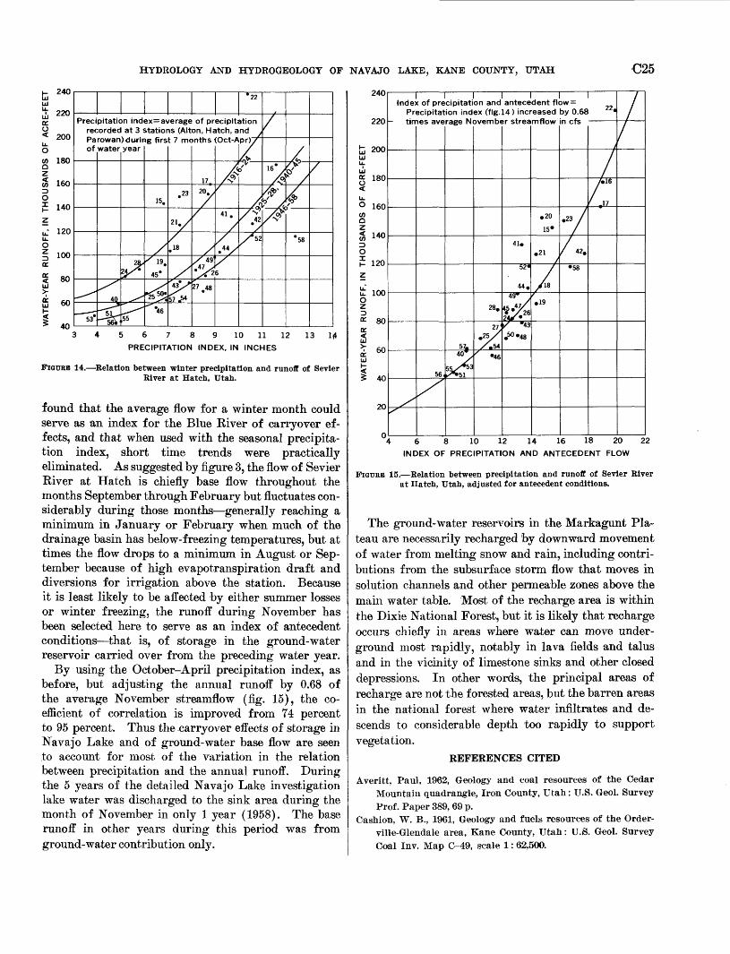
HYDROLOGY AND HYDEOGEOLOGY OF NAVAJO LAKE, KANE COUNTY, UTAH C25
240 *22
Precipitation index= average of precipitation recorded at 3 stations (Alton, Hatch, and Parowan)during first 7 months <Oct-Apr); of water year
34 5 6 7 8 9 10 11 12 13
PRECIPITATION INDEX, IN INCHES
FIGURE 14. Relation between winter precipitation, and runoff of Sevier River at Hatch, Utah.
found that the average flow for a winter month could serve as an index for the Blue Eiver of carryover ef fects, and that when used with the seasonal precipita tion index, short time trends were practically eliminated. As suggested by figure 3, the flow of Sevier River at Hatch is chiefly base flow throughout the months September through February but fluctuates con siderably during those months generally reaching a minimum in January or February when much of the drainage basin has below-freezing temperatures, but at times the flow drops to a minimum in August or Sep tember because of high evapotranspiration draft and diversions for irrigation above the station. Because it is least likely to be affected by either summer losses or winter freezing, the runoff during November has been selected here to serve as an index of antecedent conditions that is, of storage in the ground-water reservoir carried over from the preceding water year.
By using the October-April precipitation index, as before, but adjusting the annual runoff by 0.68 of the average November streamflow (fig. 15), the co efficient of correlation is improved from 74 percent to 95 percent. Thus the carryover effects of storage in Navajo Lake and of ground-water base flow are seen to account for most of the variation in the relation between precipitation and the annual runoff. During the 5 years of the detailed Navajo Lake investigation lake water was discharged to the sink area during the month of November in only 1 year (1958). The base runoff in other years during this period was from ground-water contribution only.
240
220
200
180
160
3 14°
120
100
80
60
40
20
Inde) Pr
- tin
< of pre ecipitat IBS ave
/
cipitati ion ind rage N<
579
^T
on and ex (fig. Dvembe
28.
27'
/m *A
' -46
antece 14) incr sr strea
41,
52«
44.49*
X'43
.50-48
dent fl eased mflow
.20
15"
21
7.19
3W =
by 0.68 n cfs
""/
/«. 58
22.
I
/
t
/
/
6 8 10 12 14 16 18 20
INDEX OF PRECIPITATION AND ANTECEDENT FLOW
22
FIGCEB 15. Relation between precipitation and runoff of Sevier River at Hatch, Utah, adjusted for antecedent conditions.
The ground-water reservoirs in the Markagunt Pla teau are necessarily recharged by downward movement of water from melting snow and rain, including contri butions from the subsurface storm flow that moves in solution channels and other permeable zones above the main water table. Most of the recharge area is within the Dixie National Forest, but it is likely that recharge occurs chiefly in areas where water can move under ground most rapidly, notably in lava fields and talus and in the vicinity of limestone sinks and other closed depressions. In other words, the principal areas of recharge are not the forested areas, but the barren areas in the national forest where water infiltrates and de scends to considerable depth too rapidly to support vegetation.
REFERENCES CITED
Averitt, Paul, 1962, Geology and coal resources of the CedarMountain quadrangle, Iron County, Utah: U.S. Geol. SurveyProf. Paper 389, 69 p.
Cashion, W. B., 1961, Geology and fuels resources of the Order-ville-Glendale area, Kane County, Utah: U.S. Geol. SurveyGoal Inv. Map G-49, scale 1: 62,500.

C26 CONTRIBUTIONS TO STREAM-BASIN HYDROLOGY
Fife, Arthur, 1924, Outlet of water from Navajo Lake: un published report in office of Utah State Engineer.
Gatewood, J. S., Wilson, Alfonse, Thomas, H. E. and Kister, Lester, 1961, General effects of drought upon water re sources: U.S. Geol. Survey Prof. Paper 372-B, p. 27-31.
Gregory, H. E., 1949, Geologic and geographic reconnaissance of eastern Markagunt Plateau, Utah: Bull. Geol. Soc. Amer ica, v. 60, p. 969-998.
1950, Geology of eastern Iron County, Utah: Utah Geol. and Mineral Survey Bull. 37,150 p.
Hursh, C. B., and Brater, E. F. 1941, Separating storm hydro- graphs from small drainage into surface and subsurface flow: Trans. Am. Geophys. Union v. 22, p. 863-870.
McDonald, C. C. and Langbein, W. B., 1948, Trends in runoff
in the Pacific Northwest: Trans. Am. Geophys. Union v.29, 'p. 387-397.
ParMnson, F. B., 1934, Measurements of flow at Cascade Spring:unpublished report in office of Utah State Engineer.
Peck, E. L., 1954, Streamflow as an index to the short- andlong-term carryover effects in water supply forecasting:U.S. Weather Bur. mirneo. rept., Salt Lake City, 11 p., 3 figs.
Stubbins, L. C., 1922, Water supply at Duck Lake: unpublishedreport in office of Utah State Engineer.
Thomas, H. E., and Wilson, M. T., 1960, A case of undergroundpiracy: Intern. Geol. Cong. XXI Session, Norden, Part XX,p. 24-31.
Threet, B. L., 1952, Some prpblems of the Brian Head (Tertiary)Formation in southwestern Utah [abs.]: Bull. Geol. Soc.America, v. 63, p. 1386.
The U.S. Geological Survey Library has cataloged this publication as follows:
Wilson, Milton Theurer, 1898-Hydrology and hydrogeology of Navajo Lake, Kane
County, Utah, by M. T. Wilson and H. E. Thomas. Wash ington, U.S. Govt. Print. Off., 1964.
iii, 27 p. illus., maps (1 col.) diagrs., tables. 30 cm. (U.S. Geological Survey. Professional paper 417-C)
Contributions to stream-basin hydrology.Part of illustrative matter fold, in pocket.Prepared in cooperation with the Utah Water and Power Board
and with the Cedar City Corporation.(Continued on next card)
Wilson, Milton Theurer, 1898-Hydrology and hydrogeology of Navajo Lake, Kane
County, Utah. 1964. (Card 2)
Bibliography: p. 25-26.1. Hydrology Utah Navajo Lake. 2. Geology Utah Navajo
Lake region. 3. Water, Underground Utah Navajo Lake region. I. Thomas, Harold Edgar, 1906- joint author. II. Utah. Water and Power Board. III. Title. (Series)