Embed Size (px)
Citation preview

Hydrology and geochemistry of lakes and
wetlands of the Victorian Volcanic Plains Report to the Corangamite Catchment Management Authority CCMA Project WLE/42-009: Milestone Report No. 5 Project team: A. Barton, J. Cox, R. Crosbie, P. Dahlhaus, P. Davies, J. Dighton, A. Herczeg, R. Smith
CSIRO Land and Water
March 2007

Copyright and Disclaimer
© 2007 CSIRO & Corangamite Catchment Management Authority. To the extent permitted by law, all rights are reserved and no part of this publication covered by copyright may be reproduced or copied in any form or by any means except with the written permission of CSIRO Land and Water or the Corangamite Catchment Management Authority.
Important Disclaimer:
CSIRO advises that the information contained in this publication comprises general statements based on scientific research. The reader is advised and needs to be aware that such information may be incomplete or unable to be used in any specific situation. No reliance or actions must therefore be made on that information without seeking prior expert professional, scientific and technical advice. To the extent permitted by law, CSIRO (including its employees and consultants) excludes all liability to any person for any consequences, including but not limited to all losses, damages, costs, expenses and any other compensation, arising directly or indirectly from using this publication (in part or in whole) and any information or material contained in it.
From CSIRO Land and Water Description: Installation of piezometers at northern end of Lake Colac, 28 Feb2007. Photographer: Andrew Herczeg © 2007 CSIRO

Sampling and analyses of lakes in the Corangamite CMA region ii
Report Title
Hydrology and geochemistry of lakes and wetlands of the Victorian Volcanic Plains
Authors
Project team: A. Barton1,2, J. Cox1,2, R. Crosbie1, P. Dahlhaus3,4, P. Davies1,2, J. Dighton1,2, A. Herczeg1,2, R. Smith3
Affiliations
1. CSIRO Land and Water, Private Bag 2, Glen Osmond, SA, 5064 2. CRC LEME, PO Box 1130, Bentley, WA, 6151 3. University of Ballarat, PO Box 663, Ballarat VIC, 3353 4. Dahlhaus Environmental Geology Pty Ltd, PO Box 318, Buninyong, VIC, 3357
CSIRO Land and Water
March 2007

Sampling and analyses of lakes in the Corangamite CMA region iii
Table of Contents Executive Summary............................................................................................................... 4 1. Introduction..................................................................................................................... 5 2. Lake Sampling and Chemical Analyses ....................................................................... 5 3. Collection of hydrological data ..................................................................................... 5 4. GPS survey of lake levels and nominated GW bores heights.................................... 7 5. Work Plan...................................................................................................................... 12 6. Reference ...................................................................................................................... 12

Sampling and analyses of lakes in the Corangamite CMA region 4
Executive Summary
This is the fifth milestone report for the Corangamite Catchment Management Authority (CCMA) project WLE/42-009 – Understanding the processes causing salinity of the groundwater dependent ecosystems of the CCMA.
Three lakes are now being sampled on a fortnightly basis since January 08, 2007: Lake Colac, Lake Weering and West Basin. These have a range of salinities and fall within the three types of lakes discussed in the fourth milestone report, viz, groundwater dominated/throughflow, surface water dominated/throughflow and groundwater dominated/long residence time. The monitoring will continue until about November 2007 and the samples analysed for chemistry and isotopic composition. The data will be used to evaluate changes in the source of water and water residence times in these “end-member” lakes as a function of changes in surface runoff and groundwater level.
Accurate estimates of the land surface within the vicinity of these lakes in and around the Warrion irrigation district via RTK survey was conducted in late February/early March. Six shallow piezometers were installed at the lakes and equipped with water level probes and loggers. An additional set of observation bores were selected for sampling and installation of loggers in April 2007 pending approval from Victoria Dept. of Sustainability and Environment.
Modelling of the hydrologic systems will now commence with the aim of advancing tools that can predict lake response to changes in the surface and groundwater systems.

Sampling and analyses of lakes in the Corangamite CMA region 5
1. Introduction
This is the fifth milestone report for the Corangamite Catchment Management Authority (CCMA) project WLE/42-009 – Understanding the processes causing salinity of the groundwater dependent ecosystems of the CCMA.
The current activities of the project are concentrated on evaluating the detailed hydrological and geochemical processes occurring at three lakes selected for detailed study during 2007. Lake Colac, Lake Weering and West Basin have been selected as indicative of end-member lakes within the three types of lakes discussed in the fourth milestone report, viz, groundwater dominated/throughflow, surface water dominated/throughflow and groundwater dominated/long residence time.
There are two fundamental processes controlling salinity of the lakes and wetlands: (1) the relative fraction of surface water and groundwater input and their respective salinities, and (2) the water residence time in the lakes which will influence the extent of evapo-concentration of dissolved ions. The detailed studies of the three lakes will evaluate how this changes with time in response to rainfall.
2. Lake Sampling and Chemical Analyses Fortnightly sampling commenced January 8 2007 for three study lakes (Lake Weering, Lake Colac & West Basin). Samples were collected on the following dates: 08 Jan 07, 22 Jan 07, 05 Feb 07, 19 Feb 07, 05 Mar 07, 19 Mar 07.
Samples have been sent to the CSIRO Laboratories, Adelaide, to be analysed for major ions and stable isotopes. Chemistry results for the first three sampling dates (Table 1) show that Lakes Colac and Weering have increased in salinity by about 14% over the 4 week period, while West Basin has remained constant at about 100 000 mg/L.
3. Collection of hydrological data A field trip was undertaken between 26/02/07 and 01/03/07 and two or three piezometers were installed in the three study lakes. These were installed to monitor lake water level and shallow groundwater to a depth of 1.5 metres. Using the Victorian Data Warehouse, a listing has been compiled of all active groundwater bores which are less than 25 m in depth in the vicinity of the lakes. Water level data for these lakes has been downloaded from the warehouse. Permission is now being sought from the Victorian Department of Sustainability and Environment to install water level sensors and data loggers in the several additional bores (highlighted in Table 2: 146931, 142712, 142703, 26687, 26659, 26657 & 26661) to allow a groundwater surface to be described with respect to the study lakes. Permission is also being sought from farmers to use a further 2 bores in the vicinity of West Basin as there is only one monitoring bore in close proximity this lake.

Sampling and analyses of lakes in the Corangamite CMA region 6
Table 1. Chemistry of three study lakes sampled during January and February 2007. n
* TDS is calculated as the sum of the Cl, SO4, HCO3, Na, K, Ca and Mg ions.
^ HCO3, is calculated from total alkalinity.
Sample Date
Wetland pH EC *TDS Tot Alk Cl- Br- NO3- SO4
= ^HCO3- Ca++ K+ Mg++ Na+
dS/m mg/l meq/l mg/l mg/l mg/l mg/l mg/l mg/l mg/l mg/l mg/l
08/01/07 Lake Colac 8.5 11.5 6685 9.3 3603 9.0 1.0 117 567 83 45 277 1993
22/01/07 Lake Colac 8.7 11.4 6647 8.8 3623 8.8 1.0 114 538 74 44 276 1980
05/02/07 Lake Colac 8.8 12.8 7594 9.9 4162 10 <0.5 129 605 81 50 314 2252
08/01/07 Weering stream 8.2 5.8 3579 7.0 1864 4.9 <0.5 112 426 26 31 307 814
22/01/07 Weering stream 8.1 5.9 3609 7.2 1865 4.9 1.8 118 441 27 31 317 810
05/02/07 Weering stream 8.2 6.6 4040 7.2 2132 5.7 <0.5 118 442 27 35 321 965
08/01/07 West Basin 8.7 123 100032 28.8 58600 162 8 1760 1759 12 845 1845 35210
22/01/07 West Basin 8.8 119 96408 27.9 56300 152 32 1640 1700 10 820 1777 34160
05/02/07 West Basin 8.7 123 99956 28.8 58500 165 9 1780 1757 14 861 1833 35210

Hydrology and geochemistry of lakes and wetlands, Corangamite Page 7
Another field trip is tentatively proposed for April when existing data loggers will be checked and downloaded and additional loggers installed. It is also proposed that the bores listed in Table 2 be sampled for chemistry and isotopes. Table 2. Bore numbers that will be monitored for water level (highlighted) and sampled (all) during this study.
Bores proximate to West Basin
Bores proximate to Lake Colac
Bores proximate to L. Weering
146931 142703 26660
142660 142712 26659
142668 26687 57506
26843 26657
26655 26658
26654 26661
26685 36061
142714 36059
57507
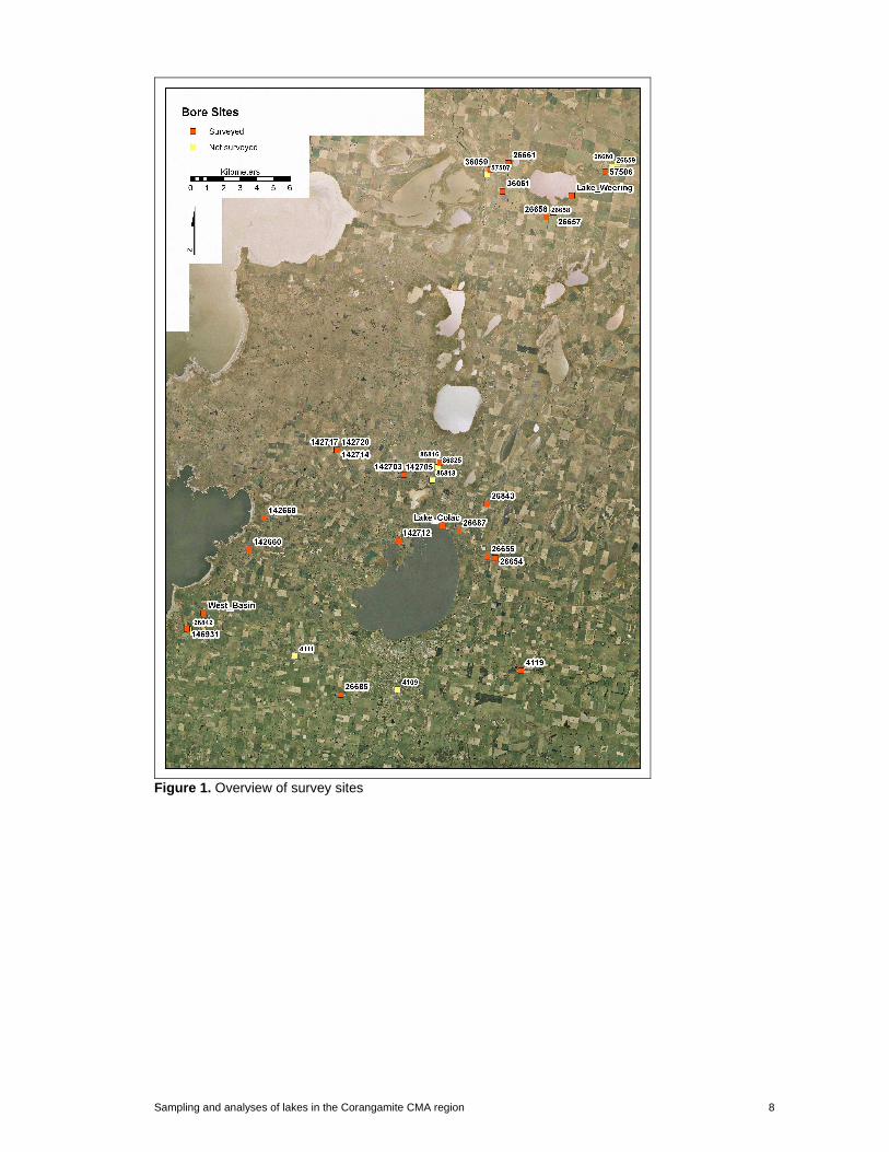
4. GPS survey of lake levels and nominated GW bores heights A real time kinematic (RTK) GPS survey was conducted across the study area in late February, 2007. The aim of the survey was to gather accurate (+/-5cm) height information for three water bodies (Lake Weering, Lake Colac and West Basin,) and key groundwater monitoring bores screened at a depth (below surface) of less than 25 m. The technical aspects relating to the conduct of the RTK-GPS survey are detailed in Williams (2004). A total of fifty four survey points at thirty bore sites were collected (Fig. 1) along with points for the piezometers and study lakes (Figs. 2-4). Of these, seven points were not surveyed accurately due to a lack of good RTK verification. Another six bore sites were not surveyed due either to difficulties in location or the sites being within private property.
Sampling and analyses of lakes in the Corangamite CMA region 8
Figure 1. Overview of survey sites

Sampling and analyses of lakes in the Corangamite CMA region 9
Figure 2. Survey sites and locations of piezometers, Lake Weering.
Figure 3. Survey sites and locations of piezometers, West Basin..

Sampling and analyses of lakes in the Corangamite CMA region 10
Figure 4. Survey sites and locations of piezometers, Lake Colac. Due to the difficulty in locating survey marks in the field of a sufficiently high enough order, the raw GPS data was post-processed using the Victorian GPSnet base station at Colac (http://www.gpsnet.com.au/). The horizontal (x, y - meters) and vertical (z - mAHD) values obtained from RTK-GPS survey are compared to values obtained from the Victorian Water Resource Data Warehouse (http://www.vicwaterdata.net/vicwaterdata/) and the computed difference (∆) shown. Mean ∆ values for the horizontal and vertical components of each survey point are: X_∆: 20.96 m Y_∆: 19.98 m Z_∆: 0.35 mAHD. The discrepancy between the mean difference in height between RTK-GPS and VicDW may warrant a further survey. Furthermore, there may be additional bores that will need to be surveyed that do not have elevations in Victorian Data Warehouse. Heights (mAHD) for the three water bodies are: Lake Weering: 111.6 Lake Colac: 115.6 West Basin: 112.7

Sampling and analyses of lakes in the Corangamite CMA region 11
Table 3. Corrected RTK-GPS data for all survey points
Note: In the Victorian Water Resource Data Warehouse, Bore no b26658 is listed as having a surface height of 199.800 mAHD. This is assumed to be a typographical error. Order decimal places 0 3 (0.001) 1 3 (0.001) 2 3 (0.001) 3 2 (0.01) 4 2 (0.01) 5 1 (0.1) 99 0 (1 - 100)

Sampling and analyses of lakes in the Corangamite CMA region 12
5. Work Plan There are two fundamental processes controlling salinity of the lakes and wetlands in the Victorian Volcanic plains: 1. the relative fraction of surface water and groundwater input and their respective salinities, and 2. the water residence time in the lakes which will influence the extent of evapo-concentration of dissolved ions. The detailed studies of the three lakes will evaluate how this changes with time in response changes in surface runoff and groundwater levels.
It is planned to continue regular sampling of Lake Colac, Lake Weering and West Basin on a fortnightly basis, and analyse these samples for major ions and stable isotopes. The data will be incorporated into an analytical solute-isotope model to estimate groundwater input and water residence time. This work will be complemented by hydrological investigations into the lake connectivity to groundwater and surface water systems.
Conceptual models of the groundwater – surface water interactions of the lakes will be developed. This will require analysing, groundwater levels and rainfall and evaporation records. It is anticipated that the chemistry investigations will link in with this work to provide corroboration/augmentation of the models.
The conceptual models will provide the backbone of surface and groundwater modelling of lake responses to surface runoff and groundwater hydrograph variations. The type and complexity of these models are to be assessed during the next 3 months of the project.
6. Reference Williams, S. (2004). DEM user notes. CSIRO Land and Water, Task Report SKW0

Hydrology and geochemistry of lakes and wetlands, Corangamite Page 13