Embed Size (px)
Citation preview
HYDROLOGIC AND WATER QUALITY MONITORING ON TURKEY CREEK WATERSHED,FRANCIS MARION NATIONAL FOREST, SC
D.M. Amatya1, T.J. Callahan2, A. Radecki-Pawlik3, P. Drewes4, C. Trettin5 and W.F. Hansen6
AUTHORS: 'Research Hydrologist, US Forest Service Center for Forested Wetlands Research, 3734 Highway 402, Cordesville, SC 29434;2Associate Professor, College of Charleston, Charleston, SC; 'Associate Professor, Agricultural University of Krakow, Krakow, Poland;4Hydrologist, USGS Field office, Conway, SC: 5Team Leader, US Forest Service Center for Forested Wetlands Research, Cordesville, SC; and6Forest Hydrologist, Sumter and Francis Marion National Forest, Columbia, SC.
REFERENCE: Proceedings of the 2008 South Carolina Water Resources Conference, held October 14-15, 2008 at the Charleston Area EventCenter
Abstract. The re-initiation of a 7,260 ha forested watershedstudy on Turkey Creek, a 3rd order stream, within the FrancisMarion National forest in South Carolina, completes thedevelopment of a multi-scale hydrology and ecosystem monitoringframework in the Atlantic Coastal Plain. Hydrology and waterquality monitoring began on the Santee Experimental Forest in the1960's, and represent an important long-term hydrological databasefor natural forested watersheds in the coastal plain. Understandingthe functional linkages between terrestrial and marine environmentsis fundamental to sustainable management of coastal plain forestsand to accommodate the rapidly expanding wildland-urbaninterface. The Turkey Creek Watershed Monitoring is a multi-collaborator effort, with a real time flow gauging station establishedin collaboration with the US Geological Survey to build upon thehistorical data (1964-1984), ground water wells that assess thesurface-subsurface flow interactions by College of Charleston andFrancis Marion National Forest, and weather station and streamwater quality sampling stations by the Forest Service. The objectiveof the collaborative effort is to address the critical issues ofsustainable water management for low-gradient forested wetlandlandscapes. Accordingly, a series of studies have been conducted inlast few years to understand the hydrology, water quality, andecosystem dynamics of this watershed. This paper attempts tosummarize results of those studies that might help managementdecisions and monitoring assessments on coastal forest lands. Theyshould also serve as reference eco-hydrologic units for comparisonwith more intensively managed forests, and developed lands in thecoastal plain. The data may serve as background data for assessingallowable pollutant loading for receiving waters from similar coastalforested watersheds.
INTRODUCTION
The purpose of this paper is to synthesize dataobtained from multi-collaborative studies being conductedon a low-gradient forested watershed within the FrancisMarion National Forest (FMNF) in coastal SouthCarolina. Urban interface and population growth createincreasing demands on the coastal resources. Hurricanes,flooding and wildfire are natural disturbances. Past landmanagement has included forestry, rice culture, farming,hydrologic modification and road networks to supportthese activities. Hydrologic information is a crucial
element for land managers, planners, and decision makersto consider to protect human health and ensure properresource management. Data from the long-term studies inthis watershed will improve understanding of the effectsof disturbance phenomena on surface and subsurfacehydrology of coastal areas. Information will be gatheredon precipitation and weather patterns, stream flowdynamics including peak flow behavior following storms,flooding and pollutant transport; weather patterns forunderstanding storms and droughts; evapotranspiration(ET) and ground water table response. This informationwill be useful to identify and describe wetland hydrology,ponding/flooding dynamics and ground water influencesand storages. Characteristics of water quality will beaddressed as affected by disturbance, season, and climate.More importantly, information from this low intensitymanaged forest eco-system provides baseline or referenceinformation for coastal forested watersheds that can beused to compare with more intensively managed forests.This information will also be helpful when quantifyingwater balance components and in developing bestmanagement practices (BMPs). The information willbenefit developers, land managers, decision makers,regulators, and researchers involved in development oflow-gradient forests.
BACKGROUND
Understanding the hydrology of watersheds along thecoastal plain is becoming critical to address both the waterquantity and quality impacts of anthropogenic factors andnatural disturbances near the coastal waters and ashydrology is the primary driving force in flooding,nutrient cycling and loading dynamics. At the watershedscale, the hydrology can be quite complex due to theheterogeneity of land use, soil, climate conditions,vegetation, and geology (Fernandez et al., 2007). Landcover, particularly forest cover plays an important role in

regulating regional hydrologic patterns through wateruptake and ET; however forested watershed dynamics incoastal plain differs considerable from uplandenvironments due to low-gradient topography, climate,and soil composition, and is generally dependent upon theposition of the water table (and hence the storage capacityof the soil).
Watershed-scale hydrologic models thatsimultaneously analyze topographic, soil, vegetation, landuse, and vegetation spatial data together with climatic dataover space and time are becoming valuable tools formaking decisions on alternative BMP scenarios tomitigate the negative impact of anthropogenic activitieson water quantity and quality (Bosch et al., 2004). Mostmodels available are either for uplands (Arnold et al.,1998; Young et al., 1989) or for artificially drained lowgradient systems (Amatya et al., 2004; Fernandez et al.,2007). Furthermore, only a few of these agricultural-based models, originally developed for agriculturalsystems, have been tested on forest ecosystems. Fieldmeasurements, testing, calibration and validation of thesemodels are required before their operational application.Another goal of this program is to build strong partnershipand collaborative effort for sustained comprehensivemonitoring. This paper summarizes results from thecollaborative monitoring studies being conducted on a7,260 ha Turkey Creek watershed at FMNF in coastalSouth Carolina (Fig. 1).
METHODS
Site Description
Figure 1. Location map and layout of Turkey Creekwatershed at Francis Marion National Forest, SC.
The Turkey Creek, a third-order stream that drainsapproximately 7,260 ha is located at 33° 08 N latitude and79° 47 W longitude approximately 60 km north-west ofCity of Charleston near Huger, South Carolina (Fig. 1). Itis located within the East Branch of the Cooper River,which drains to the Charleston Harbor System, TurkeyCreek (WS 78) is typical of other watersheds in the southAtlantic coastal plain where rapid urban development istaking place. The topographic elevation of the watershedvaries from 3.6 m at the stream gauging station to 14 mabove mean sea level (a.m.s.l.). The sub-tropical climate ischaracteristic of the coastal plain having hot and humidsummers and moderate winter seasons. The long-term(1951-2000) minimum and maximum daily temperaturesrecorded at the nearby Santee Experimental Forest were -8.5°C and 37.7°C, respectively, with an average dailytemperature of 18.4°C.
Land use within the watershed is comprised of 57.7%(4,191 ha) loblolly (Pinus taeda L.) and long leaf pine(Pinus palmtris) forest, 39.7% (2,884 ha) forestedwetland and hardwood, and 2.6% (189 ha) in crop lands,roads and open areas (Haley, 2007). The watershed washeavily impacted by Hurricane Hugo in September 1989,and the forest canopy was almost completely destroyed(Hook et al., 1991). Most of the current forests on thewatershed are a mixture of remnant large trees and naturalregeneration. The watershed is dominated by poorlydrained soils of Wahee (clayey, mixed, thermic AerieOchraquults) and Lenoir (clayey, mixed, Thermic AeriePaleaquults) series (SCS, 1980). The watershed alsocontains small areas of somewhat poorly and moderatelywell drained sandy and loamy soils. Current managementpractices on the majority of the watershed includeforestry, biomass and thinning removal for reducing firehazards and improving forest health. Prescribed fire andthinning for restoration of fire dependant species commonto native longleaf pine and savannah habitat such as thered-cockaded woodpeckers (Picoides borealis), anendangered species. The watershed is also used forrecreational purposes such as hunting, fishing, birdwatching, hiking, canoeing, biking, historical tours, horseriding, all-terrain vehicle (ATV) use, and agriculture.
Rainfall
Rainfall and air temperature have been continuouslymeasured since 1946 using a manual gauge and standardthermometer, respectively, at the weather station locatedat the Santee Experimental Forest Headquarters (Fig. 1).This was upgraded with an automatic instrumentation(Campbell Scientific CR-10X station) in 1996. Since1964 a network of manual gauges across the watershedrecords rainfall on a weekly basis. At present there are
two tipping bucket rain gauges: one in the middle and oneat the outlet of the watershed. There are three moreautomatic gauges adjacent to the watershed. Annualrainfall at the site has varied from 830 mm to 1940 mm,with an average of 1370 mm for the 1951-2000 period.Seasonally, the winter is generally wet with low intensitylong duration rain events and the summer is characterizedby short duration, high intensity storm events; tropicaldepression storms are not uncommon.
Stream Flows
The original flow gauging station on Turkey Creekwas 800m downstream of the existing site with measuredstages of the stream from 1964 to 1984. Calculatedstream flow data obtained from these historic records weredigitized by Tetra-Tech, Inc., a project cooperator.
The current eco-hydrological monitoring andmodeling program on Turkey Creek watershed (Amatyaand Trettin, 2007a) was reactivated by the Forest Service,Southern Research Station, Center for Forested WetlandsResearch (www.srs.fs.usda.gov/charleston/) by installing areal-time stream flow and rainfall gauging station onHighway 4 IN approximately 800 m upstream of the(waterdata.usgs.gov/sc/nwis/uv?site no=02172035)previous gauging station in cooperation with the USGeological Survey (USGS) College of Charleston(www.cofc.edu) and the. Flow rates were calculated usinga stage-discharge relationship developed by the USGS.
Weather parameters
Historically only rain and temperature were availablefrom the nearby Santee Experimental Forest (SEF)Headquarters station. Campbell Scientific CR10Xweather stations were installed at the SEF site in 1996 andin the middle of the Turkey Creek watershed in 2005 toprovide necessary meteorological data such as airtemperature, soil temperature, relative humidity, windspeed and direction, and solar and net radiation needed forwater balance and hydrological modeling studies (Amatyaand Trettin 2007b; Amatya et al., 2008; Haley, 2007).
Water Table Depths
There are no historic ground water table data at thesite. Four shallow ground water table monitoring wellsprovided by the Francis Marion National Forest wereinstalled in four different soil types (Rains, Goldsboro,Lynchburg, and Lenoir series) in 2006 to measure watertable up to 2.5 m depth. A cluster of deep wells(piezometers) measuring the water table depth up to 25 mwas installed by College of Charleston in 2005.
Water Quality
Little water quality data were available for the TurkeyCreek watershed, except some water samples werecollected in 2001 from a section of the stream about onekm upstream of the current gauging station on TurkeyCreek as one of the three locations in Francis MarionNational Forest used to examine several water qualityparameters, including fecal coliform, methyl mercury,dissolved oxygen (DO), conductivity, total dissolvedsolids, and salinity (Plewa and Hansen, 2003).
A more complete characterization of water qualitywas initiated at the new gauging station in October, 2005.In June 2006 the sampling protocol was augmented withthe addition flow proportional sampling of storm eventsusing an ISCO-4200 automatic sampler. Both the graband automatic samples are being analyzed for nutrients(NO3-N, NH4-N, Total N, and PO4) and some other cat-ions (Ca+, K+, Na+,) and Cl". Furthermore, bi-weekly in-situ measurements of physical parameters such as (pH,dissolved oxygen (DO), temperature, and conductivity)are also being conducted using a Eureca in-situ meter.
RESULTS
Amatya and Trettin (2007c) presented a history ofdevelopment of watershed research on Turkey Creekwatershed until its revitalization plan in 2004 (Amatyaand Trettin, 2007a) with the goal, objectives, and plans fora multi-cooperative monitoring effort on the watershedwith current and future studies outlined.
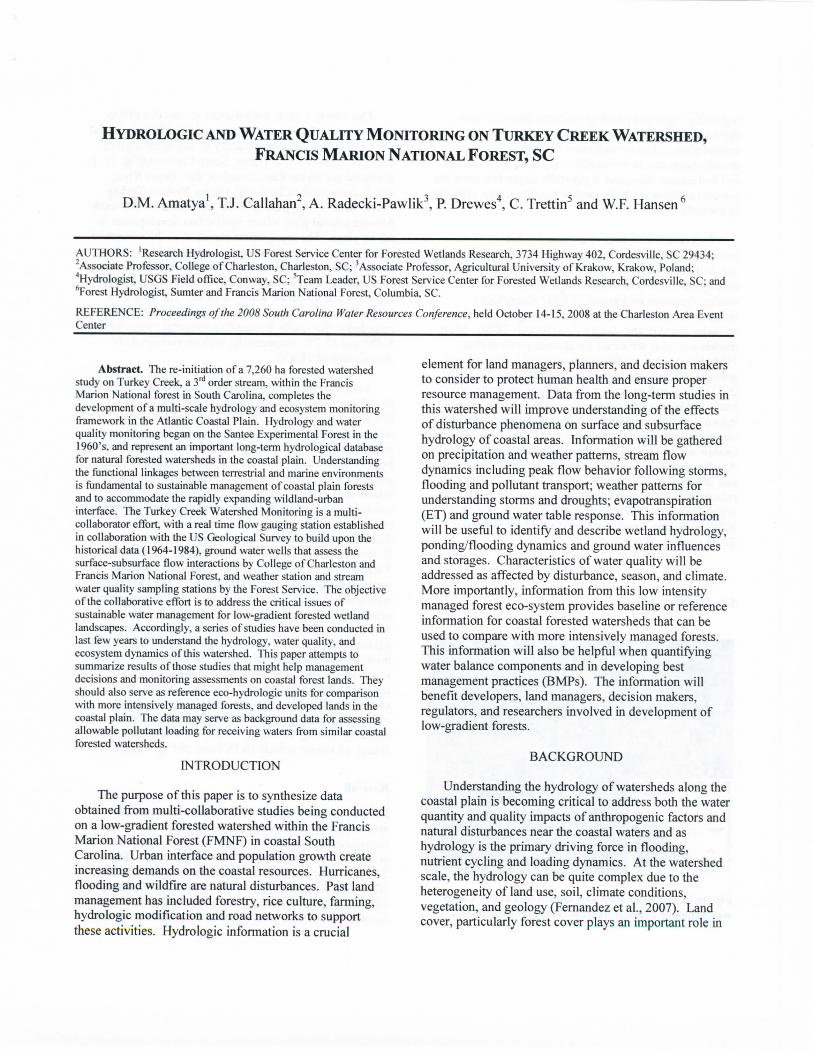
Using 13 years (1964-76) of historic data, Amatyaand Radecki-Pawlik (2007) conducted a study to comparethe stream flow dynamics of Turkey Creek watershed(WS 78) with that of the adjacent 1st and 2nd order forestedwatersheds (WS 80 and WS 79) at the adjacent SanteeExperimental Forest (Fig. 2). The mean annual runoffcoefficient for the study site for the 13-yr period (1964-76) was 25%. The largest watershed (study site) withsome open lands, roads, and wetlands yielded higherannual water yields compared to the two other smallerones with mostly forest vegetation, possibly due todifference in land use, soils and topography as well asincreased base flows. As expected, the daily flowspersisted for 79% of the time on this largest 3rd orderwatershed with a larger storage compared to the 2nd and 1st
order watersheds. The runoff coefficient varied from 11%in a dry year to as much as 38% in a wet year, with anaverage of 25%. Although the annual runoff coefficientspresented here may provide insight on average watershedresponse, it is important to understand the seasonaldynamics as affected by soil moisture and ET.
0.10 1.00 10.00
Percent of time flow exceeded
WS 78 - - - - WS 79 WS 80 |
Figure 2. Daily flow duration curve of Turkey Creekwatershed compared to 1st and 2nd order watersheds.
The flow frequency analysis with 13 years of data,employing Pearson Ill-type distribution, revealed the peakflows for 100-, 50-, 25-, 10-, and 5-year return periods as1805, 1565, 1326, 1009, and 769 cfs, respectively. Theseresults, which are in good agreement with publishedUSGS data for the South Carolina Lower Coastal Plain,may have implications in design of engineering structures,water and nutrient management as well as in evaluation ofimpacts of development and natural disturbances on theforested lands in the region.
La Torres (2008) analyzed historic rainfall and streamflow data (1964-73) in which 51 storm events wereidentified for further analysis of rainfall-runoffrelationships as affected by seasonal climate dynamics.The runoff ratios were higher during winter-springpossibly due to surplus water conditions (decreased ET)than the summer, but peak flow rates, on average, werelarger during the summer than in winter, possibly due tohigh intensity summer storm events. Runoff ratios werefound to be highly influenced by the antecedent moistureconditions (i.e. base flow values). Both the rainfall-runoffand rainfall-peak flow rate relationships were significantonly for spring and summer seasons. These data wereused to test the Rational and SCS-CN methods forpredicting the peak flow rates and the runoff. The authorconcluded that these methods may not be applicable onthis large 3rd order watershed due to limitation of scale.
Amatya and Trettin (2007b) evaluated four differentmethods of estimating annual ET using the forest coverdata, 13 years (1964-76) of rainfall, temperature, andstream flow data. The measured mean annual ET, as thedifference between the rainfall and stream flow, was 983mm and the annual ET remained to be near potential ET(>90% of average Thornthwaite PET of 1079 mm) for theyears exceeding the long-term average rainfall and/or theyears with just below the average but with the wetantecedent year. Results of assessing the impacts ofreduction in forest cover on mean annual runoff usingTurner and Lu et al methods indicated an increase of as
much as 62% runoff as a result of removal of 90% forestcover on the study watershed.
Haley (2007) tested the Soil and Water AssessmentTool (SWAT) hydrology model to calculate the waterbudget of the watershed for two years (2005 - wet and2006 - dry) and to predict hydrological responses to stormevents such as stream outflow, including surface andsubsurface flows, and ET. Sensitivity analysis providedimprovements to the calibration of Soil ConservationServices (SCS) curve numbers (CN), available soil watercontent, and Manning's roughness parameters in themodel. Given the limited field measured data forcalibration, the SWAT model produced satisfactoryestimates of daily and monthly runoff.
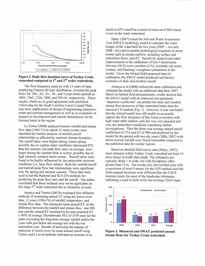
Amatya et al (2008) refined the same calibration andvalidated the model with an additional data from 2007.Based on limited field measurements, results showed thatthe SWAT model with an improved one-parameter"depletion coefficient" can predict the daily and monthlystream flow processes of this watershed better than theclassical CN method (Fig. 3). However, it was concludedthat the refined model was still unable to accuratelycapture the flow dynamics of this forest ecosystem withhigh water table shallow soils for very wet saturated andvery dry antecedent conditions warranting furtherinvestigations. Thus the three-year average annual runoffcoefficient of 17% and ET of 900 mm predicted by themodel for the period with two dry years (2006, 2007) withbelow normal rainfall were found reasonable compared tothe published data for similar regions.
Based on detailed field survey data (Haley, 2007),most channels within Turkey Creek watershed are least 10times larger in width than depth. The tributaries aretypically about 1 m wide, but with floodplains oftengreater than 25 m. The results also showed that even witha maximum of error 9 meters for the GPS method used thefield-mapped locations were different than the USGSlocation points for most of the headwater tributaries,indicating a need to field verify the existing USGS maps.
Average
Figure 3. Measured and SWAT predicted annualstream flows for Turkey Creek watershed.
Owarek (2008) recently developed a GIS-based toolto estimate surface depressional storage coefficient (DSC)for forested wetlands in the coastal plain including theTurkey Creek watershed using the available digitalelevation models (OEMs). The author reported anaverage DSC value of about 10 cm for this watershed.Estimate of DSC values are critical in surface runoffmanagement and modeling, and wetland restoration.
CONCLUSIONS
The basic hydrologic and water quality monitoringand related studies conducted so far on this forestedwatershed on shallow water table soils show that therunoff process is dynamic (very dry to very wet with 25%of the annual rainfall lost to mean annual runoff) asaffected by seasonal rainfall and ET. The mean annualestimated ET (900 to 980 mm) is consistent with similarother published results, and removal of forest vegetationmay have a substantial impact on stream outflowsprimarily due to decreased interception and ET. Fieldverification of streams is necessary before applying thedata in restoration and modeling works.
Additional efforts are already underway to describesurface-groundwater interactions for water balance, andthe hydraulics of cross drainage structures for flow pathdescription and water management on the study site. Thusthe ongoing multi-collaborative monitoring effort on theTurkey Creek should be continued and expanded toinclude additional studies such as biogeochemicalprocesses and in-stream transport, development of a wellcalibrated and validated model such as SWAT and others.Such models could then be used to fill further gaps inunderstanding the processes and address the "what-if'scenarios for management decisions facing the landmanagers working in the forested lands.
ACKNOWLEDGEMENTS
The authors would like to acknowledge John Erblandand Whitney for help with stream flow and rain data andAndy Harrison and Amy Edwards of Forest Service forhelp with weather and rainfall data from additionalstations and GIS data.
LITERATURE CITED
Amatya, D.M. and Radecki-Pawlik, A. 2007. Flow dynamics ofthree experimental forested watersheds in coastal South Carolina,U.S.A. Acta Scientiarium Polonorum Formatio Cirtumiectus, no.1, 2007.
Amatya, D.M. and C.C. Trettin. 2007a. An Eco-hydrologicalProject on Turkey Creek Watershed, South Carolina, U.S.A. In P.Meire et al. (eds.) "Integrated Water Management: Practical
Experiences and Case Studies", Springer, Netherlands, pp:l 15-126.
Amatya, D. M. and C.C. Trettin. 2007b. Annual evapotranspirationof a forested wetland watershed, SC. Paper # 072222, St. Joseph,MI:ASABE. 16p.
Amatya, D.M. and Trettin. 2007c. Development of WatershedHydrologic Research at Santee Experimental Forest, CoastalSouth Carolina. In Furniss et al. (eds.): Advancing theFundamental Sciences: Proceedings of the Forest ServiceNational Earth Science Conference, San Diego, California.October 18-22, 2004, PNW-GTR-689, pp:180-190.
Amatya, D.M., E.B. Haley, N.S. Levine, T.J. Callahan, A. Radecki-Pawlik, and M. Jha. 2008. Calibration and Validation of theSWAT Model for a Forested Watershed I Coastal South Carolina.Paper # 083912, St. Joseph, MI: ASABE, 17 p.
Amatya, D.M., G.M. Cheschier, G.P. Fernandez, R.W. Skaggs, andJ.W. Gilliam. 2004. DRAINWAT - based methods for estimatingnitrogen transport on poorly drained watersheds. Trans, of theASAE.47(3): 677-687.
Amoah, J.K. 2008. A New Methodology for Estimating Watershed-Scale Depression Storage. Ph.D. Dissertation, Civil &Environmental Engineering Department, Florida A&MUniversity, Tallahassee, FL
Arnold, J.G., Srinivasan, R., Muttiah, R.S., and Williams, J.R. 1998.Large area hydrological modeling and assessment. Part I: Modeldevelopment. Journal of American Water Resources Association34(1): 73-89.
Bosch, D.D., Sheridan, J.M, Batten, H.L., and Arnold, J.G. 2004.Evaluation of the SWAT model on a coastal plain agriculturalwatershed. Trans, of the ASAE 47 (5): 1493-1506.
Fernandez, G., Chescheir, G.M., Skaggs, R.W. and Amatya, D.M.2007. Application of DRAINMOD-G1S to a Lower Coastal PlainWatershed. Trans, of the ASABE. 50(2): 439-447.
Haley, E.B. 2007. Field Measurements and Hydrologic Modeling ofthe Turkey Creek Watershed, South Carolina. MS thesis.Charleston, South Carolina: College of Charleston, 168 p.
Hook, D.D., M.A. Buford, and T.M. Williams. 1991. Impact ofHurricane Hugo on the South Carolina Coastal Pine Forest. J. ofCoastal Research, SI (8):291-300.
La Torres, I. 2008. Seasonal Relationships between Precipitationand Stream Flow Patterns Related to Watershed Characteristics ofTwo Third-Order Coastal Plain Watersheds in South Carolina.MS thesis. Charleston, SC: College of Charleston, 221 p.
Plewa, T. and W.F. Hansen. 2003. Current Status of Water QualityInformation on the Francis Marion NF. Unpublished USFSReport, Columbia, SC. 43 p.
SCS. 1980. Soil Survey of Berkeley County, South Carolina. SoilConservation Service, Washington, D.C., United StatesDepartment of Agriculture, 94 p.
Young, R.A., Onstad, C.A., Bosch, D. and Anderson, W.P. 1989.AGNPS: A nonpoint source pollution model for evaluatingagricultural watersheds. Journal of Soil and Water Conservation44(2): 168-173.

![Ancient history [by D.M. Masson]....Title Ancient history [by D.M. Masson]. Author David Mather Masson](https://img.pdfslide.us/doc/110x75/60ec6d4334ac5766a325c5a1/ancient-history-by-dm-masson-title-ancient-history-by-dm-masson-author.jpg)