Embed Size (px)
Citation preview

Photonirvachak Journal of the Indian Society of Remote Sensing, Vol. 27, No. 1, 1999
Hydrogeomorphological Mapping in Assessing Ground Water by Using Remote Sensing Data -
A Case Study in Lehra Gaga Block, Sangrur District, Punjab
ABRAHAM THOMAS, P K SHARMA, MANOJ K SHARMA* and ANIL SOOD
Puniab Remote Sensing Centre, Ludhiana- 141 004 *Department of soil science, CCS Haryana Agricultural University, Hissar- 125 004
I n t r o d u c t i o n
The available surface water resources are inadequate to meet all the water requirements for all purposes. So the demand for ground water has increased over years. The assessment of quantity and quality o f ground water is essential for its optional utilization. The Interpretation of satellite data in conjunction with sufficient ground truth information makes
it possible to identify and outline various ground features such as geological structures, geomorphic features and their hydraulic characters (Das et al. 1997), that may serve as direct or indirect indicators of the presence of ground water (Ravindran and Jeyaram (1997). The chemical composition o f water is an important factor to be considered before it is used for domestic, irrigation or industrial purposes (Suresh et al. 1991). However, the
(Recd. 18 Dec. '97; in final tbrm 1 5 May. '99)

32 Abraham Thomas et al.
quality and quantity of ground water is controlled mainly by the interaction of topographical, geological, metereological and pedological features. Moreover ground water distribution is not uniform and is subject to wide spatio-temporal variations, depending on the underlying rock formation, their structural fabric, geometry, surface expression etc. Therefore, a detailed hydrogeomorphological mapping and ground water quality survey can give a clear picture of the groundwater resources and the associated problems (Thomas et al, 1995). The present study is an attempt to evaluate groundwater conditions in the Lehra Gaga block of Sangrur district, Punjab, through hydrogeomorphological studies using remote ~ensing data and to establish a relation between hydrogeomorpholgy and ground water quality.
Study Area
Lehra Gaga block is situated in the south western corner of the Sangrur district bordering the Haryana State. This block belonging to the Sunam tehsil has got a geographical area of 747 sq km. It lies between latitudes 29 ~ 43' 45" & 30 ~ 01' 55" N and longitudes 75 ~ 38'33 & 76 ~ 07' 24" E. This block is bounded by Sunam block on the north, Samana block of Patiala district on the north east and Budhlada block of Mansa district on the north west. The southern and the south eastern sides are bound by the neighbouring Haryana state. All the villages in this block are approachable by rail and road network. The Lehra Gaga block of Sangrur district enjoys semi arid (dry) type of climate characterised by extreme summer and chilly winter with large seasonal as well as monthly fluctuations in" both temperature and rainfall.
Methodology
The Indian Remote Sensing Satellite (IRS 1B LISS 11) data acquired on two seasons (October t992 and March 1993) in the form of false r r composites (FCC's) generated from
bands 2, 3 & 4 on 1:50,000 scale was interpreted using visual interpretation techniques. The local knowledge of the area has been taken into consideration at the time of interpretation. The interpreted features and units were transferred to the base maps prepared from Survey of India topographic maps on 1:50,000 scale. The ground water prospects of the delineated geomorphic units were evaluated using available hydrogeologic characteristics and aquifer parameters. The hydrogeomorpho- logical map of the area was finalised after field checks at selected locations for verifying the doubtful units. A detailed ground water quality survey was also conducted. Ground water samples from 118 operational tubewells respresenting different geomorphic units were collected during the month of April (1995). The water table depth at each operational tubewell was recorded and a water table contour map of the area was prepared. The analysis of water samples for various constituents was undertaken following the methods outlined by Richards (1954). The water quality was judged as per the criteria laid down by soil testing laboratory, Department of Soils, PAU, Ludhiana Table I. The ground water quality map was prepared on 1:50,000 scale showing four categories of ground water.
Results and Discussion
Geomorphology
Visual interpretation of FCC reveals that the entire Lehra Gaga block is more or less flat with a gentle slope towards south west direction and forms a part of the vast Indo-Gangetic alluvial plain. The monotony of the vast plain area is disturbed by the presence of sand dunes of various dimensions scattered all over especially in the western and the north eastern parts of the block. The major geomorphic units identified in this block are the alluvial plain, sand dunes (tibbas), palaeo chanels and the Ghagar river !F~g. 1).

Hydrogeomorphological Mapping in Assessing Ground Water... 33
Q .
+ U
Q ..,.1 en
,-.1
J
-+il ,•{,
0 �9 �9
!+ I -
/
" ' ' ) 1 I ('
~s,, " .
~ i
r176
. " o o
o
\ -~ I I
" ' ~ 0 / /
,o ..'~176
"'v.~. ...... ~.+U
[ '~
i I r t +
,.1. o~ !
o C
.a 0
+,3
x
,I.
\oc,~.
o m

34 Abraham Thomas et al.
Table 1. Criteria used tbr the rating of ground waters of Lehra Gaga Block.
Category* Ground Water Quality Map Symbol EC(dS m 1) RSC(me L -I)
Sultabtlity for Irrigation
I <2 <2.5 2-4 <2 5
II 2-4 2.5-5.0
IIl 2 2.5-7.5
Suitable for all conditions Suitable for coarse textured soils/salt tolerant crops with periodic monitoring of salt accumulation in soils.
Suitable after mixing with canal water
Suitable with recommended gypsum application
IV >4 5.0-7.5 Unsuitable <4 >7.5 Unsuitable
*I." Good," 11 and 111. Marginal," IV. Poor
Table 2. Lithology and groundwater prospects of the hydrogeomorphic units.
Map Geomorphic Ltthology Groundwater Symbol Unit Prospects
1 Alluvial Plain Beds of Sand, Excellent Silt and Clay
2 Sand Dunes Very Fine Moderate to Sand and Silt Excellent
3 Alluvial Plain- Sand, Silt and Excellent Salt Affected Clay
4 Alluvial Plain- -Do- -Do- Water Logged
5 Palaeo Channel -Do- -Do- (Seasonally Water Logged)

Hydrogeomorphological Mapping in Assessing Ground Water... 35
.....I
I..=/
v
C~
. . p
DIS T R\ ~" /~'~,~. ~
J
[~E]BB ~ / , l l l .~

36 Abraham Thomas et al.
Alluvial plain
Alluvial plain is the major geomorphic unit in the area, and is under intensive cultivation. It occupy nearly 80 per cent area and is composed of finer sediments. Within the alluvial plain, there are localized slightly low lying areas, affected by water logging, soil salinity or alkalinity or both. About 1.52 per cent of the block area has the water logging problem whereas 2.37 per cent of the area is affected by salinity or sodicity. The problems of water logging and salinity may be the result of one or more of the following factors: floods, a rise in the water table, low lying topography, seepage from canals, etc. (Sehgal et al. 1973).
Sand dunes (ttbbas)
The sand dunes locally called tibbas found in the area are generally low having heights up four metre above the ground level. Sand bars are generally associated with old filled up channels and occur mainly as elongated stretches without any preferred orientation. They are believed to be the remnants of the combined effect of fluviatile and aeolian actions (Sehgal et al., 1973). They occupy about 1.65 per cent of the total area. Most of the sand dunes are stable, whereas some of these are still active and change their position and orientation according to the wind velocity and direction.
Palaeo Channels
The prominent palaeochannels are observed mainly in the south eastern portion of the area especially along/near the Ghagar river. This tract of land is characterised by seasonal water logging. They occupy low lying topographic position on the landscape and are believed to be the remnants of the old active channels. The origin of these channels may be ascribed to the frequent changes in the course of the ancient Satluj river and its tributaries which became defunct and silted up. These old
channels cover about one per cent of the total area and occupy a low lying topographic position on the landscape.
Ghagar flood plain
The Ghagar river passes through the southern part of the block from east to almost west. During monsoon, this seasonal river occasionally floods the surrounding area causing huge damage to the crops on either side.
Hydrogeological Conditions
The geological facts reveal that the entire Lehra Gaga block forms a part of the vast Indo- Gangetic alluvial plain (G.S.1. 1976). The whole expanse of the plain under study is a part of the watershed area between the Indus and the Ganga systems and is believed to have been formed from the alluvial deposits of the ancient Satluj river and its tributaries (Sehgal et al., 1973). The alluvial sediments of the area comprise massive beds of sand, silt and clay mixed with kankar (calcium carbonate deposits of secondary origin) of Quaternary age.
The aquifers in the area belong to the huge aquifers of the lndo-Gangetic alluvial plain consisting mainly of sand or sand with admixture of clay bands. Ground water occurs in two sand beds separated by a more less persistent thick clay bed which is almost uniformly present around 160 metre depth. The ground water in the lower sand bed is under confined and unconfined conditions depending upon whether or not clay lenses are present in the upper aquifer. (GSI. 1976). The water table depth in the area varies from 1.5 to 18 metre (near Daska, Karel, Balram, Khanauri, Bangan villages) below the surface. Field observations indicate that the tubewells are located very close to each other according to the convenience of farmers and hence the depth of the water table varies randomly from one place to another. The
Hydrogeomorphological Mapping in Assessing Ground Water... 37
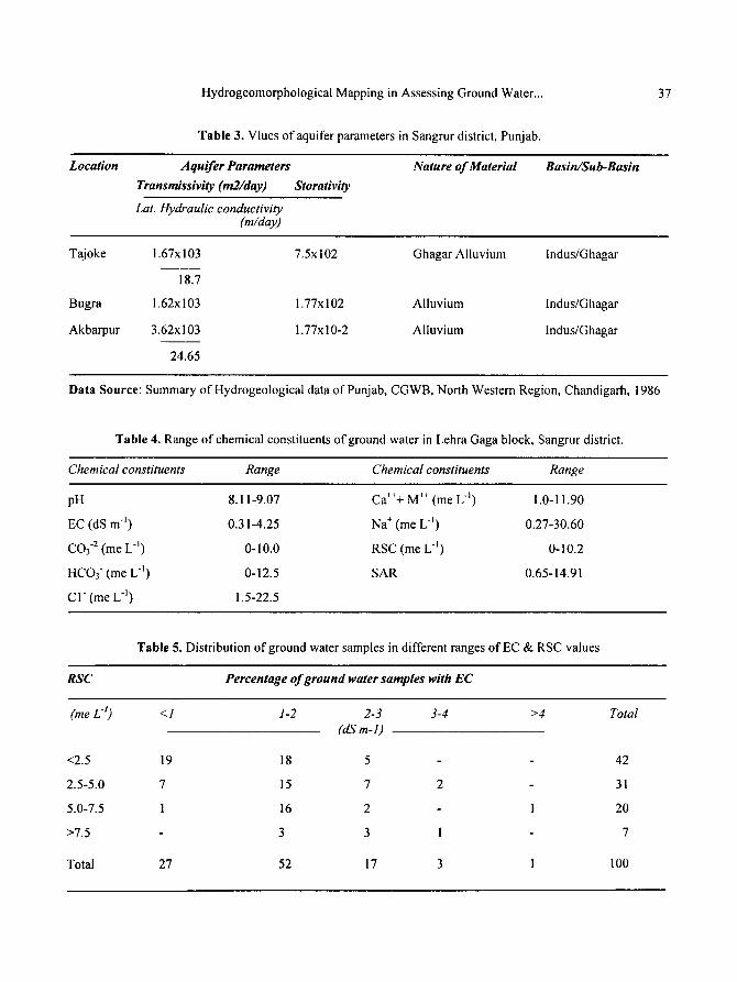
Table 3. Vlues of aquifer parameters in Sangrur district, Puniab.
Location Aquifer Parameters Nature of Material Basin~Sub-Basin
Transmissivity (m2/day) Storativity
Lat. Hydraulic conductivity (m/day)
Tajoke 1.67x!03 7.5x10² Ghagar Alluvium lndus/Ghagar
18.7
Bugra 1.62x10³ 1.77x10² Alluvium Indus/Ghagar
Akbarpur 3.62x ! 03 1.77x 10⁻² Alluvium lndus/Ghagar
24.65
Data Source: Summary of Hydrogeological data of Punjab, CGWB, North Western Region, Chandigarh, 1986
Table 4. Range of chemical constituents of ground water in Lehra Gaga block, Sangrur district.
Chemical constituents Range Chemical constituents Range
pH 8.11-9.07 Ca+++ M +§ (me L l ) 1.0-11.90
EC (dS m j ) 0.3 I-4.25 Na + (me L -]) 0.27-30.60
CO3 -2 (me L "l) O- 10.0 RSC (me L "l) 0-10.2
HCO3 (me L l ) 0-12.5 SAR 0.65-14.91
C I (me L -j) 1.5-22.5
Table 5. Distribution of ground water samples in different ranges ofEC & RSC values
RSC Percentage of ground water samples with EC
(me L t) <1 1-2 2-3 3-4 >4 Total (dS m-1)
19 18 5 42
7 15 7 2 31
I 16 2 1 20
3 3 I 7
27 52 17 3 1 100
<2.5
2.5-5.0
5.0-7.5
>7.5
Total
38 Abraham Thomas et al.
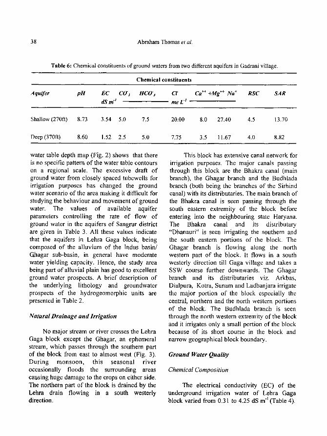
Table 6: Chemical constituents of ground waters from two different aquifers in Gadrani village.
Chemical constituents
Aqui fer p H E C CO'z HCO-3 Cr Ca ++ +Mg ++ Na § R S C
dS m -1 reeL -I
S A R
Shallow (270ft) 8.73 3.54 5.0 7.5 20.00 8.0 27.40 4.5 13.70
Deep (370fi) 8.60 1.52 2.5 5.0 7.75 3.5 11.67 4.0 8.82
water table depth map (Fig. 2) shows that there is no specific pattern of the water table contours on a regional scale. The excessive draft of ground water from closely spaced tubewells for irrigation purposes has changed the ground water scenario of the area making it difficult for studying the behaviour and movement of ground water. The values of available aquifer parameters controlling the rate of flow of ground water in the aquifers of Sangrur district are given in Table 3. All these values indicate that the aquifers in Lehra Gaga block, being composed of the alluvium of the Indus basin/ Ghagar sub-basin, in general have moderate water yielding capacity. Hence, the study area being part of alluvial plain has good to excellent ground water prospects. A brief description of the underlying lithology and groundwater prospects of the hydrogeomorphic units are presented in Table 2.
Natural Drainage and Irrigation
No major stream or river crosses the Lehra Gaga block except the Ghagar, an ephemeral stream, which passes through the southern part of the block from east to almost west (Fig. 3). During monsoon, this seasonal river occasionally floods the surrounding areas causing huge damage to the crops on either side. The northern part of the block is drained by the Lehra drain flowing in a south westerly direction.
This block has extensive canal network for irrigation purposes. The major canals passing through this block are the Bhakra canal (main branch), the Ghagar branch and the Budhlada branch (both being the branches of the Sirhind canal) with its distributaries. The main branch of the Bhakra canal is seen passing through the south eastern extremity of the block before entering into the neighbouring state Haryana. The Bhakra canal and its distributary "Dhanauri" is seen irrigating the southern and the south eastern portions of the block. The Ghagar branch is flowing along the north western part of the block. It flows in a south westerly direction till Gaga village and takes a SSW course further downwards. The Ghagar branch and its distributaries viz. Arkbas, Dialpura, Kotra, Sunam and Ladbanjara irrigate the major portion of the block especially the central, northern and the north western portions of the block. The Budhlada branch is seen through the north western extremity of the block and it irrigates only a small portion of the block because of its short course in the block and narrow geographical block boundary.
Ground W a t e r Q u a l i t y
C h e m i c a l C o m p o s i t i o n
The electrical conductivity (EC) of the underground irrigation water of Lehra Gaga block varied from 0.31 to 4.25 dS m "1 (Table 4).

CANAL NETWORK AND DRAINAGE
II r A
/-
\ "-,,
~,
./~
--
/.~
~
, .-
' --
~._
,\~-~
F
k
,-?
I o
I
: 5A
5A
L E
~
E
N
D
E~ol
mda
ry
Sta
te
....
....
.
Bloc
k ..
....
..
Roa
d
RaB
,.'ay
I~ve
r
I~..s
trib
u:ar
y
Set
li~m
~nt
Torn
(BLO
CK
LE
HR
A [i
AF,
A}
r, hcr
a,
Hab
6'
% }-
AT
IA
r~!5
T~'C
T
# #
L
i .r r
I
'e"
,~ ~
4,
/
Na.
a~ao
~ ~ /.d
J
i �9
/
/ ..,
,%..i
4
1,
,.<
ffQ
0 0 qQ R"
"0
O~ c)
Fig
. 3

fiRO
UNDW
ATE
R O
.UA
LITY
(B
LOC
K L
EH
RA
GAG
A}
MAP
..
..
..
.
i .
..
..
.
..#
~.
..
:===
===
~ ,.
L::~
-'-'-,
r.m
l
I !
2 )
~cm
,.P
N
L
GENE
RAL L
EGEN
D io
unda
ry
Sta
te
....
....
] I
Bloc
k R
oad
~ai
lway
:an
al
~ive
r
~efl'
lem
enf
-y-
L
s -G
E
,N
D
:Y
MBO
L C
ATE
GO
RY
~1
GO
OD (L
OW
El.
LOW
RSC
I
~11
M
ARG
INAL
-SAL
INE (H
IGH
El.
LOW
RSC
~
~11
1 HA
RGIN
AL-S
ODI
C |LO
W E
l:. H
IGH
RSC)
F~--
~-~I
V PO
OR
(HIG
H EC
. HIG
H R
SI:I
..r
~ ~" -
,r_-
_--_
.-_-
_- -._
-_ .-
,~_ .
-._-
,, r
~ r
-~
..
..
..
..
..
.
t t-
../
~.~
--=
--E
--_-
'-._
- _-
- -..
, p
A T
: A
L A
,:_~
..
....
..
T1T
:.:~
r
~
,,.:.-
~.
")+
4-@
+
i +
.-%
++
.q
"-
- ..~
.~
__
_ Y
-4-4
-+
§
§
.i. a
e4-4
-4-~
...a
r4-4
-4-§
I
"4"
§2
47
4
-4-.
I.§
24
7 ~
~ "t
" 4-
4- "
4- -v
4-
4- §
-b
4-
4- 4
- 4-
4-
4- \
1"
4-§
24
72
47
"~
-4-§
24
7
§2
47
24
72
47
24
72
47
24
72
47
4-+
@@
++
@@
+
A
4"
.++
+~
".-_-
-_---
--_-~
,
4~
> cr"
O
Fig
. 4

Hydrogeomorphological Mapping in Assessing Ground Water... 41
However, in majority of cases (79%) the EC was less than 2 dS m ~and only 1 per cent samples have EC more than 4 dS m -1 (Table 5), thereby indicating that concentration of soluble salts are well within the limit and posing no problem to plant growth. The soluble carbonates and bicarbonates in the water samples varied from nil to 10.0 and nil to 12.5 me L l , respectively. The concentration of carbonates and bicarbonate anions is important because these effect the precipitation of calcium and thereby result in excessive sodium salinisation in soil (Sood et al. 1998). The residual sodium carbonate (RSC) of the ground water samples varied from nil to 10.2 me L "l and 58 per cent samples have RSC > 2.5 (Table 5), thereby indicating that sodicity is more prevalent in the area than salinity. The indiscriminate use of these und~ground water is expected to build excessive sodium in soil solution and exchange complex. To avoid this, recommended doses of gypsum need to be applied alongwith irrigation waters having moderate "to high RSC. The soluble sodium content in the underground water varied from 0.27 to 30.60 me L "~, whereas that of Ca 2+ + Mg 2+ varied from 1.00 to 11.90 me L -I. The sodium adsorption ratio (SAR) values are found to be varying from 0.65 to 14.91. The study showed that 79 per cent samples have SAR value < 10.0 and the rest of the samples have SAR > 10.0.
The aquifer depth have an effect on the chemical composition of groundwater. The analysis of underground water samples collected from two aquifer depth i.e. shallow aquifer (270ft) and deeper aquifer (370ft) revealed that
the water quality in the deeper aquifer is good as it in having low values of EC, RSC and SAR as compared to shallow aquifer (Table 6). The results clearly showed that farmers need to be advised to install deeper tubewells in the area to draw good quality water for irrigation from deeper aquifer (370 ft or more)
Spatial distribution
Based on the quality index (Table 1) the water quality in Lehra Gaga block has been grouped into four categories (Fig. 4), viz Good (I), Marginal-saline (II), Marginal-sodic (111) and Poor (IV). The study revealed that 41, 7, 44 and 8 per cent samples, fall under category 1, 11, III and IV respectively. It is interesting to note good quality of irrigation water (Cat. I) covering 46 per cent of the geographical area in the block is found mainly in the areas adjacent to Ghagar river and along the major canals viz., Bhakra canal (main branch) and Ghagar branch of the Sirhind canal. Similar observations were made by Sood et al. 1998, while studying the water quality of tehsil Talwandi Sabo in Bathinda district of Punjab. The category 1I water rated as marginal-saline covering 6 per cent of the area is mainly found towards Lehra town. The marginal-sodic water (Cat. III) covering 46 per cent of the area in the block is distributed all over the block and is suitable for irrigation only after the application of recommended doses of gypsum. The poor quality water of category IV (i.e. water having either EC>4 dS m-I or RSC > 7.5 me L -t and both) is unfit for irrigation and covers only 2 per cent area of the block.
Hydrogeomorphology vs Ground Water Quality
A comparison of the hydrogeomorpho- logical map and the ground water quality map (Fig. 1 & 4) shows that, in general, there is no direct relationship of water quality with the major geomorphic units. The quality of the underground water depends primarily on the lithology of the underlying water bearing formations of the area. The lndo-Gangetic alluvial plain, consisting principally beds of sand, silt and clay with kankar, constitute the major geomorphic unit of the area. The sand dunes observed in the area are mainly low dunes formed over the alluvial plain as a result of the

42 Abraham Thomas et al.
fluvial and aeolian actions and it has no direct relationship with the under ground water of the area. This study shows that there is no homogeneity 'of ground water quality within the major geomorphic unit, instead there is distinct variation in quality of water in the alluvial plain itself which might be due to change of lithology of the aquifer system with the presence/absence of Kankar. The excessive draft of ground water from closely spaced tubewells for irrigation purpose may be responsible for the present scenario. However, the study shows that good quality waters rated as category I are found in the areas adjacent to Ghagar River and along the major canals viz. the Bhakra canal (main branch) and the Ghagar branch of the Sirhind canal. This may be due to the undergrouna seepage of fresh water from the river and the canals. Thus remote sensing technology played an important role in accurately mapping the hydrogeomorphic unit and the major canal network of the area, which ultimately paves a way for identifying the interrelationship of these units.
Conclusions
The study revealed the usefulness of remote sensing technology for preparing a hydromorphogeological map. The study shows that the area being an alluvial plain has good ground water prospects but the quality of water is marginal in general except the south eastern part of the area on either side of Ghagar river and along the major canals, where it is good. The inter-relationship of hydromorphogeo- logical units and other topographical features (especially canal networks) with the ground water is brought out clearly in this study.
Acknowledgem ents
Authors wish to thank NNRMS, Department of Space, for providing funds under IMSD Project for this study. Authors also wish to express sincere gratitude to the scientists of
PRSC, Ludhiana, especially Sh. Rajiv Chopra, Scientist SE, Sh. V.K. Verma, Sh. S.S. Dhaliwal Scientists SD, and Sh. L.B. Patel, Scientist SC, for their assistance and constructive suggestions in successfully completing this work.
References
Das S, Behera S C, Kar A, Narendra P and Guha S (1997). Hydrogeomorphological Mapping in Ground Water Exploration using. Remotely Sensed Data - A case study in Keunjhar District, Orissa, J. Indian Soc. Remote Sensing 25 (4): 247-260.
G S I (1976). Know your District- Sangrur, Punjab, 125th Anniversary Celebrations, Geological Survey of India, 1976.
Ravindran K V and Jeyaram A (1997). Groundwater prospects of Shahbad Tehsil, Baran District, Eastern Rajasthan : A Remote Sensing Approach. J. Indian Soc. Remote Sensing 25 (4): 239-246.
Richards L A (ed.) (1954). Diagnosis and Improvement of Saline and Alkali Soils (USDA) Handbook No. 60, Oxford and IBH Publishing Co. Pvt. Ltd., New Delhi.
Sehgal J L, Sharma P K, Randhawa ~ S, Singh Gurbachan and associates (1973). Salt affected soils of the Sangrur Dist. and their management. Research Bulletin of.Department of Soils, Punjab Agricultural University, Ludhiana in co-operation with the Department of Soils, Punjab Agricultural University, Ludhiana in co-operation with the Department of Soil, Conservation & Engineering, Punjab.
Sood A, Verma V K, Thomas A, Sharma P K and Brar J S (1998). Assessment and Management of Underground Water Quality in Talwandi Sabo Tehsil of Bathinda District (Punjab). J Indian Soc. Soil Sci. 46 (3): 421 - 426.
Suresh T S, Naganna C and Srinivas G (1991 ). Study of water quality for Agricultural use in Hemavathy River (Karnataka). Hydrology J. (Indian Association of Hydrologists), 14 (4): 247 - 254.
Thomas A, Verma V K, Sood A, Litoria P K, Sharma P K and Ravindran, K V (1995). Hydrogeology of Talwandi Sabo Tehsil, Bathinda District (Punjab): A Remote Sensing Approach. J. Indian Soc. Remote Sensing, 23(2): 47 - 56.