Embed Size (px)
Citation preview
EGN 98 C^tcA SxfLO*"&
Hydrogeology of spoil at three
abandoned surface mines in Illinois
preliminary results
David E. Lindorff
Keros Cartwright
Beverly L. Herzog
? *- '.'.'V'J
>^ >JLM
>:
*«j* »•
Etti^i,. -r
A4.
,**, Alj»?iS 1-. ^ ^yVjy -«*• *
*~%z5^ - «
7\-4N — —•
— ; •**iki^ttlBaiL\ir: .PPR^^Pf^Hlpj^'"^?* ^F^**
-'Sjll*^'"'"^'5'^^
*,
m^^^^
^
"'•'• ... ': ~
*
ifcw
y'%xi^ .'
$
Illinois Institute of Natural Resources
STATE GEOLOGICAL SURVEY DIVISION
Jack A. Simon, Chief
ENVIRONMENTAL GEOLOGY NOTES 98
May 1981
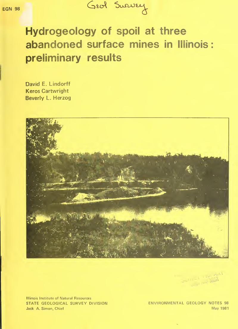
Cover photo: Recreational area at the Coal City
study site.
Lindorff, David E.
Hydrogeology of spoil at three abandoned surface
mines in Illinois / by David E. Lindorff . . . [et al.]
.
— Champaign, IL : State Geological Survey Division,
April 1981.
18 p. ; 28 cm. — (Environmental Geology Notes;
98)
1. Strip mining-Environmental aspects. 2. Spoil
banks. I. Title. II. Series.
ILLINOIS STATE GEOLOGICALSURVEY
3 3051 00005 3193
Printed by authority of the State of Illinois/1981/2000.
Hydrogeology of spoil at three
abandoned surface mines in Illinois
preliminary results
David E. Lindorff
Keros Cartwright
Beverly L. Herzog
ILLINOIS STATE GEOLOGICAL SURVEYNatural Resources Building
615 East Peabody Drive
Champaign, IL 61820
ENVIRONMENTAL GEOLOGY NOTES 98
May 1981
Digitized by the Internet Archive
in 2012 with funding from
University of Illinois Urbana-Champaign
http://archive.org/details/hydrogeologyofsp98lind
CONTENTS
ABSTRACT 1
INTRODUCTION 1
Background 1
Previous work 1
Objectives 2
Site selection 3
OTTAWA STUDY AREA 3
Geology 3
Ground water 5
COAL CITY STUDY AREA 6
Geology 6
Ground water 9
HARRISBURG STUDY AREA 9
Geology 9
Ground water 12
DISCUSSION 12
REFERENCES 15
APPENDIX: Logs of Borings 17
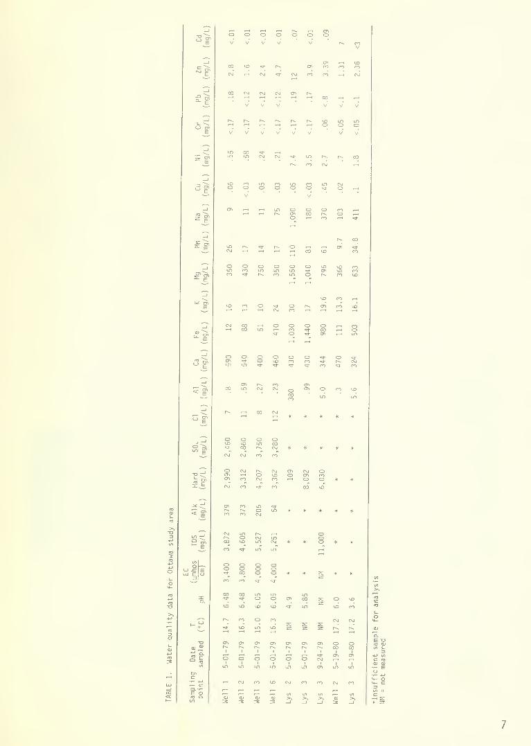
TABLES1. Water quality data for Ottawa study area 7
2. Water quality data for Coal City study area 10
3. Water quality data for Harrisburg study area 11
4. Summary of water quality at 3 study sites 13
FIGURES1. Locations of study areas at Ottawa, Coal City, and Harrisburg 3
2. Locations of monitoring wells and instruments
at Ottawa study area, La Salle County 4
3. Stratigraphic correlation of the Carbondale Formation in Illinois 5
4. Idealized cross section of La Salle Anticline near Ottawa 5
5. Barren landscape at Ottawa study area 6
6. Cross section of Ottawa study area showing relationships
of the stratigraphy and ground water 6
7. Recreational area at the Coal City study site 8
8. Locations of monitoring wells and instruments
at Coal City study area, Grundy County 9
9. Locations of monitoring wells and instruments
at Harrisburg study area, Saline County 12

Hydrogeology of spoil at three
abandoned surface mines in Illinois
:
preliminary results
ABSTRACT
The impact of surface coal mining on the geologic materials and ground waterin different geologic settings is under investigation at three abandoned sur-
face mines in Illinois. At a site near Ottawa, the overburden prior to
mining consisted largely of pyritic shale; sand was the major component of
the overburden and spoil at a mine near Coal City. Clays, lacustrine silts,and some shale and limestone were the predominant premining overburdenmaterials at a mine near Harrisburg. Ground-water elevations at Coal Cityand Harrisburg are approximately at premining levels, whereas at Ottawa they
are near the base of the spoil. Ground-water quality has deteriorated at all
three sites, especially at Ottawa and Harrisburg.
INTRODUCTION
Background
Although coal was first surface mined commercially in the United States in
1866, underground mining provided nearly all the coal produced in the nine-teenth and early twentieth centuries. The development of large strippingequipment in the early 1900s stimulated the expansion of the surface miningindustry. Today, surface mining is a major method of coal extraction. Nearlyhalf of the coal mined in Illinois comes from surface mines; United Statescoal production from surface and underground mines will undoubtedly increaseto meet future energy needs.
The Federal Surface Mining Control and Reclamation Act was enacted in 1977with the intent to minimize the deleterious effects of mining on the environ-ment. The act specifically requires a characterization of the hydrogeology ofany mine site and an assessment of the hydrologic conditions expected aftermining and reclamation. Although no mining permit can be approved withoutthis information, hydrogeologic data are sparse regarding the impact of sur-face mining on ground water in flat, glaciated terrains such as are commonthroughout Illinois.
Previous work
From 1955 to 1966, the U.S. Geological Survey compared surface-water andground-water conditions in mined and unmined drainage basins in southeasternKentucky (Collier, Pickering, and Musser, 1970). Changes caused by surface
mining included increases in acidity and mineralization in surface and groundwater and an increase in sedimentation in the mined watershed. Ground-waterlevels in the spoil appeared to stabilize relatively quickly after miningstopped. Mezga (1973) investigated the changes caused by surface mining in
the surface-water and ground-water hydrology of a small watershed in Ohio.The spoil, consisting largely of weathered shale, had an average porosity of
44 percent and an average hydraulic conductivity of 4.1 x 10~ 3 cm/sec. Theground-water velocity was calculated to be 1.7 m (5.5 ft) per day. Duringthe past several years, researchers at Iowa State University have monitoredground-water conditions during and after mining and reclamation at a small
surface mine in Iowa. Preliminary data suggested that the spoil, which waslargely glacial till and shale, was slowly becoming saturated with water(Sendlein and Stangl , 1977).
In western Illinois (Fulton County), the Metropolitan Sanitary District ofGreater Chicago studied surficial materials and ground-water quality in strip-mined and unmined land in the early 1970s before establishing a sludge dis-posal program. The pH of the mine spoil averaged 7.4, whereas the samplesfrom undisturbed lands averaged 6.5; the spoil generally showed higher elec-trical conductivity values than the samples from the undisturbed land (Petersonand Papp-Vary, 1972). A comparison of ground water from mined and unminedsites suggested that ground-water quality deteriorated because of mining. The
quality of the ground water in the mine spoil varied greatly as a result of the
heterogeneous chemical and physical character of the spoil (Pietz, Peterson,and Lue-Hing, 1974).
Argonne National Laboratory also has investigated the impact of a gob pile on
ground water in southern Illinois. The site is underlain by calcareous, siltyclay till. Shallow ground water around the gob pile (within 120 m) is
generally low in pH and has high concentrations of dissolved metals and sulfate,
Beyond 120 m (400 ft), water quality improved significantly (Schubert, 01 sen,
and Zellmer, 1978; and Schubert, 1979).
Haynes and Klimstra (1975a, 1975b) inventoried surface-mined lands in Illinoisand determined some physical and chemical properties of selected spoil materi-als; however, no correlation was made with the original overburden geology.
Acidic spoil was found to occur in all areas of surface-mined land in the state.
A number of studies have provided useful information regarding the hydrology of
surface mines in the Midwest; however, we need a better understanding of the
interactions between mine spoil and ground water in different geologic environ-ments to allow evaluation of the hydrogeologic consequences of future surfacemining. Because surface mining will continue to be a major method for ex-
tracting coal, and because data on the hydrogeologic impacts of surface miningin flat, glaciated terrain are sparse, the Illinois State Geological Surveybegan in 1977 a long-term study to generate these data. Although the studyconcerns Illinois surface mines only, the variety of geologic environments in
Illinois can provide information applicable to many other parts of the country.
Objectives
The original study had four objectives:
(1) To characterize the physical and chemical propertiesof mine spoil .
(2) To determine the effect of mining on ground water by
comparing conditions in unmined areas with those in
adjacent mined areas. (Hydrogeologic and geochemicalconditions were examined in both the saturated andunsaturated zones.
)
(3) To examine and compare mine spoil and ground-waterconditions in different geologic settings.
(4) To develop a method for evaluating the hydrogeologicconsequences of surface mining.
Site selection
Three abandoned surface mines have been selected and instrumented to date.
Two sites are in northern Illinois—one near Ottawa and one near Coal City—and the third is near Harrisburg in southern Illinois (fig. 1). The three study
areas have not been mined since the
1940s or early 1950s. The Surveybegan its work at the Ottawa site in
1977, at the Coal City site in 1978,
and at the Harrisburg site in 1979.
Each site has a different type of over-
burden. At Ottawa, the overburden con-
sisted largely of pyritic shale, where-
as sand was the major component of the
overburden and spoil at Coal City, and
lacustrine silts and clay were pre-
dominant at the Harrisburg site.
O 50 km(ZBZH
OTTAWA STUDY AREA
Geology
FIGURE 1. Locations of study areas at Ottawa,Coal City, and Harrisburg.
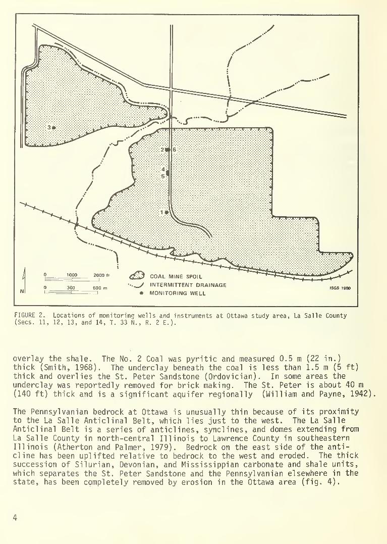
The Ottawa study area sits on an up-
land at the edge of a bluff over-looking the Illinois River and is
approximately 9 km (6 mi) west ofOttawa in La Salle County (fig. 2).
The Osage Coal Company mined the areain the late 1930s; the mine was aban-doned in 1949. The coal mined at this
site was the Colchester (No. 2) Coal
Member, which is equivalent to the
Colchester Coal Member (Ilia) in
Indiana and the Schultztown Coal in
Kentucky (fig. 3).
The premining overburden measured 3 to
8 m (10 to 25 ft) thick and consistedchiefly of gray shale (Francis CreekShale Member); pyrite was common in
the lower 1.5 m (5 ft). Up to 3 m
(10 ft) of loess and glacial till
COAL MINE SPOIL
INTERMITTENT DRAINAGE• MONITORING WELL
ISGS 1980
FIGURE 2. Locations of monitoring wells and instruments at Ottawa study area, La Salle County(Sees. 11, 12, 13, and 14, T. 33 N., R. 2 E.).
overlay the shale. The No. 2 Coal was pyritic and measured 0.5 m (22 in.)
thick (Smith, 1968). The underclay beneath the coal is less than 1.5 m (5 ft)
thick and overlies the St. Peter Sandstone (Ordovician) . In some areas theunderclay was reportedly removed for brick making. The St. Peter is about 40 m(140 ft) thick and is a significant aquifer regionally (William and Payne, 1942)
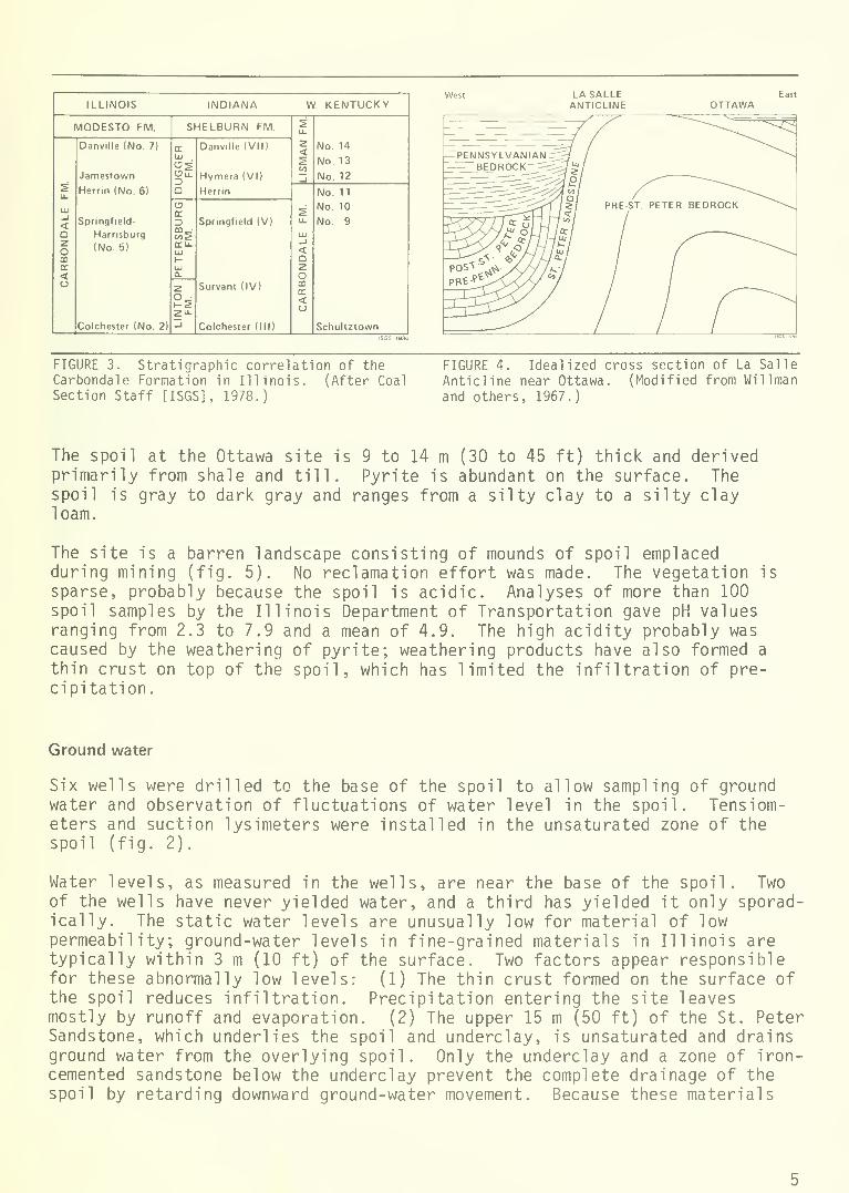
The Pennsylvanian bedrock at Ottawa is unusually thin because of its proximityto the La Salle Anticlinal Belt, which lies just to the west. The La SalleAnticlinal Belt is a series of anticlines, synclines, and domes extending fromLa Salle County in north-central Illinois to Lawrence County in southeasternIllinois (Atherton and Palmer, 1979). Bedrock on the east side of the anti-cline has been uplifted relative to bedrock to the west and eroded. The thicksuccession of Silurian, Devonian, and Mississippian carbonate and shale units,which separates the St. Peter Sandstone and the Pennsylvanian elsewhere in thestate, has been completely removed by erosion in the Ottawa area (fig. 4).
ILLINOIS INDIANA W. KENTUCKY
MODESTO FM. SHELBURN FM. 2u.
2<s(/>
_l
No. 14
No. 13
No. 12
s1L
111
_l
<Q2omDC
<(J
Danville (No. 7)
Jamestown
Herrin (No. 6)
Springfield
Harnsburg
(No. 5)
Colchester (No. 2)
ELLI
OSOilDQ
Danville (VII)
Hymera (VI)
Herrin
u.
LLI
_l
<Q2OmE<
No. 11
No. 10
No. 9
Schultztown
C3ECD
CELLtu
UJ
Springfield (V)
Survant (IV)
Colchester (III)
z
2"-_1
West East
OTTAWA
FIGURE 3. Stratigraphic correlation of theCarbondale Formation in Illinois. (After Coal
Section Staff [ISGS], 1978.)
FIGURE 4. Idealized cross section of La Salle
Anticline near Ottawa. (Modified from Willman
and others, 1967.
)
The spoil at the Ottawa site is 9 to 14 m (30 to 45 ft) thick and derivedprimarily from shale and till. Pyrite is abundant on the surface. Thespoil is gray to dark gray and ranges from a silty clay to a silty clayloam.
The site is a barren landscape consisting of mounds of spoil emplacedduring mining (fig. 5). No reclamation effort was made. The vegetation is
sparse, probably because the spoil is acidic. Analyses of more than 100spoil samples by the Illinois Department of Transportation gave pH valuesranging from 2.3 to 7.9 and a mean of 4.9. The high acidity probably wascaused by the weathering of pyrite; weathering products have also formed a
thin crust on top of the spoil, which has limited the infiltration of pre-cipitation.
Ground water
Six wells were drilled to the base of the spoil to allow sampling of groundwater and observation of fluctuations of water level in the spoil. Tensiom-eters and suction lysimeters were installed in the unsaturated zone of thespoil (fig. 2).
Water levels, as measured in the wells, are near the base of the spoil. Twoof the wells have never yielded water, and a third has yielded it only sporad-ically. The static water levels are unusually low for material of lowpermeability; ground-water levels in fine-grained materials in Illinois aretypically within 3 m (10 ft) of the surface. Two factors appear responsiblefor these abnormally low levels: (1) The thin crust formed on the surface ofthe spoil reduces infiltration. Precipitation entering the site leavesmostly by runoff and evaporation. (2) The upper 15 m (50 ft) of the St. PeterSandstone, which underlies the spoil and underclay, is unsaturated and drainsground water from the overlying spoil. Only the underclay and a zone of iron-cemented sandstone below the underclay prevent the complete drainage of thespoil by retarding downward ground-water movement. Because these materials
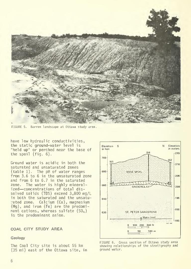
FIGURE 5. Barren landscape at Ottawa study area
have low hydraulic conductivities,the static ground-water level is
"held up" or perched near the base ofthe spoil (fig. 6).
Ground water is acidic in both the
saturated and unsaturated zones(table 1). The pH of water rangesfrom 3.6 to 6 in the unsaturated zoneand from 6 to 6.7 in the saturatedzone. The water is highly mineral-ized—concentrations of total dis-solved solids (TDS) exceed 3,800 mg/Lin both the saturated and the unsatu-rated zone. Calcium (Ca), magnesium(Mg), and iron (Fe) are the predomi-nant cations, whereas sulfate (S0 4 )
is the predominant anion.
COAL CITY STUDY AREA
Geology
The Coal City site is about 55 km
(35 mi) east of the Ottawa site, in
Elevation
in feet
700
680
660
640
620
W4
N Elevation
in meters
215
210
UNDERCLAY'
ST. PETER SANDSTONE
:'i Water level
100 200 300 ft
1 I I I
50 100 m
205
200
195
190
185
FIGURE 6. Cross section of Ottawa study area
showing relationships of the stratigraphy and
ground water.
<n .—
i
cr> .,—i .—
i
o CO t—
)
r-« O r-in i-h «a-
O ^H00 fH01 .—I
X * *
crv i—icsj o<Tt COo o *
Oo
* * -X
oo* o *
CM •-< r-H
I— cE O
a different geologic setting. Sand is the predominant spoil material.Northern Illinois Coal Corporation mined in this portion of Grundy County in
the 1930s and completed surface mining in 1946. The Colchester (No. 2) CoalMember was mined in the study area in the early 1940s.
Before mining, an aeolian sand ridge extended across the study area. Sand todepths of 4.5 to 8 m (15 to 25 ft) overlay up to 3 m (10 ft) of fine-grainedglacial drift which in turn overlay up to 4 m (15 ft) of Pennsylvanian shaleand sandstone (Francis Creek Shale Member); the bedrock contained little visiblepyrite. The No. 2 Coal measured up to 1 m (3 ft) thick and contained smallamounts of pyrite. Beneath the coal, a thin underclay overlies about 15 m (50 ft)of Pennsylvanian shale and sandstone (Culver, 1922). Unlike the Ottawa site,more than 130 m (400 ft) of carbonate rocks and shale separate the base of theNo. 2 Coal and the top of the St. Peter Sandstone at Coal City.
The spoil at Coal City is 12 to 18 m (40 to 60 ft) thick and consists largelyof medium sand. Little gravel or fine-grained sediment is mixed with the sand.The relatively small amount of fine-grained spoil was derived from lacustrinesilts and clays, glacial till, and shale. There is little evidence of theacidic (pyritic) spoil that is present at Ottawa.
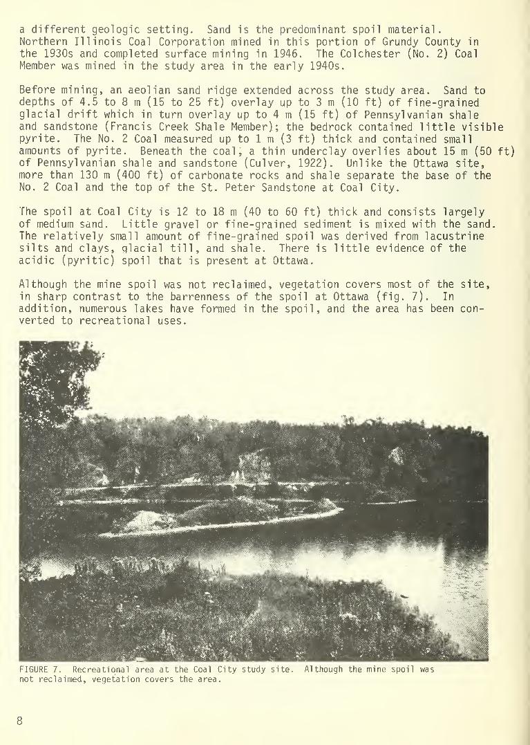
Although the mine spoil was not reclaimed, vegetation covers most of the site,in sharp contrast to the barrenness of the spoil at Ottawa (fig. 7). In
addition, numerous lakes have formed in the spoil, and the area has been con-verted to recreational uses.
FIGURE 7. Recreational area at the Coal City study site.
not reclaimed, vegetation covers the area.
Although the mine spoil was
8
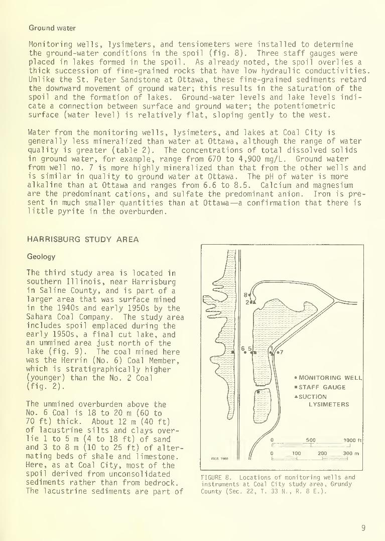
Ground water
Monitoring wells, lysimeters,the ground-water conditions i
placed in lakes formed in thethick succession of fine-graiUnlike the St. Peter Sandstonthe downward movement of grouspoil and the formation of la
cate a connection between sursurface (water level) is rela
and tensiometers were installed to determinen the spoil (fig. 8). Three staff gauges werespoil. As already noted, the spoil overlies a
ned rocks that have low hydraulic conductivitiese at Ottawa, these fine-grained sediments retardnd water; this results in the saturation of the
kes. Ground-water levels and lake levels indi-
face and ground water; the potentiometrictively flat, sloping gently to the west.
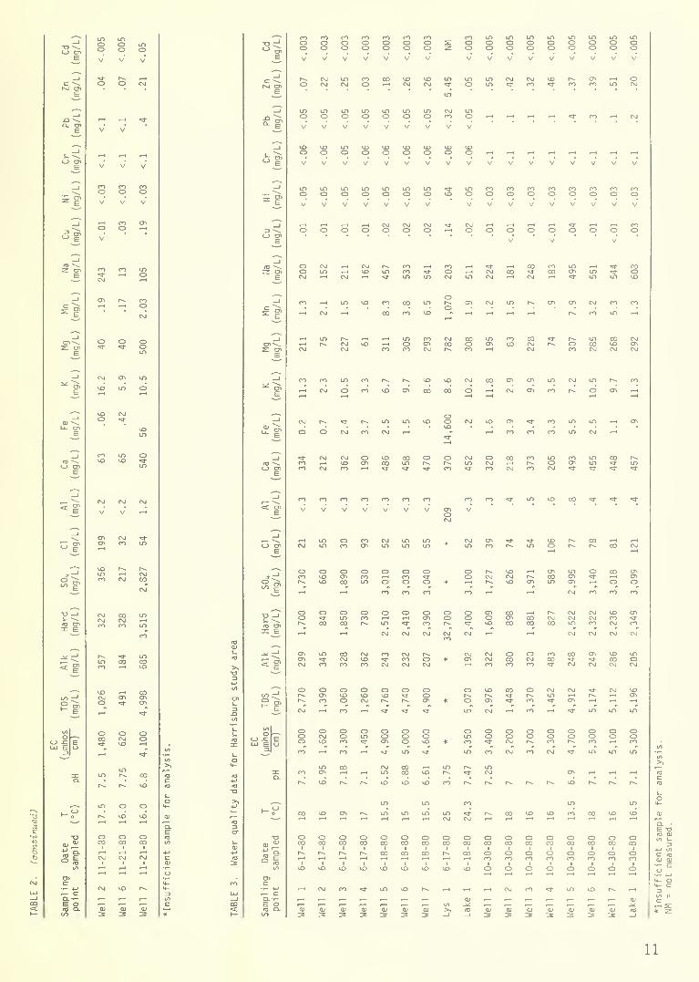
Water from the monitoring wells, lysimeters, and lakes at Coal City is
generally less mineralized than water at Ottawa, although the range of waterquality is greater (table 2). The concentrations of total dissolved solidsin ground water, for example, range from 670 to 4,900 mg/L. Ground waterfrom well no. 7 is more highly mineralized than that from the other wells andis similar in quality to ground water at Ottawa. The pH of water is morealkaline than at Ottawa and ranges from 6.6 to 8.5. Calcium and magnesiumare the predominant cations, and sulfate the predominant anion. Iron is pre-sent in much smaller quantities than at Ottawa—a confirmation that there is
little pyrite in the overburden.
HARRISBURG STUDY AREA
Geology
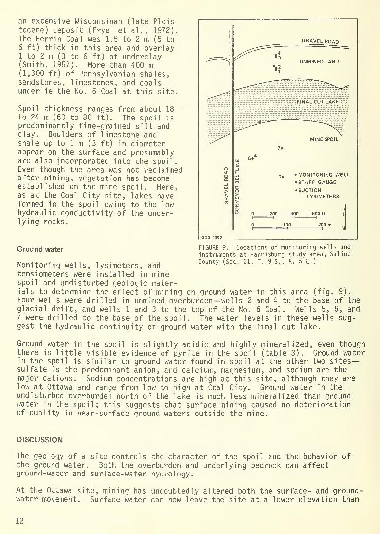
The third study area is located in
southern Illinois, near Harrisburgin Saline County, and is part of a
larger area that was surface minedin the 1940s and early 1950s by theSahara Coal Company. The study areaincludes spoil emplaced during theearly 1950s, a final cut lake, andan unmined area just north of thelake (fig. 9). The coal mined herewas the Herrin (No. 6) Coal Member,which is stratigraphically higher(younger) than the No. 2 Coal(fig. 2).
The unmined overburden above theNo. 6 Coal is 18 to 20 m (60 to70 ft) thick. About 12 m (40 ft)of lacustrine silts and clays over-lie 1 to 5 m (4 to 18 ft) of sandand 3 to 8 m (10 to 25 ft) of alter-nating beds of shale and limestone.Here, as at Coal City, most of thespoil derived from unconsolidatedsediments rather than from bedrock.The lacustrine sediments are part of
lOOO ft
300 m
FIGURE 8. Locations of monitoring wells andinstruments at Coal City study area, GrundyCounty (Sec. 22, T. 33 N., R. 8 E.).

-o<-> cn o o O o o o LO
CM o =1-O OP--oo
P^OOp^OO oo OO oo
P^Oo *COoo
COooCOoo
LOooLOoo
LOOoLOoo
LOooLOoo
fc V V V V V V V V V V V V V V V V V V V V V V V
pm enCM o COo CMO o CMo 1"o CMo CMO LO
i—
1
cnLOo
<=1-
"=1-o oCM
LO*1-o o p-.
o CM*
"3-
ooLOOo
p^oo CMw—(
CMO CMO CMo COt-H
cot-H
E
—I
a. cnE
CM
V
CM
V
CM
V
CM
V
CM
V
CM
V
CM
V
CM
V
CM
V V V V V V V V V V V V V V V V V V
_i
cj enE
CO
V
CO
V
CO
V
CO
V
CO
V
p*-OV
I
—
oV
oV
r-.oV
00oV
LOoV
LOoV
LOOV
LOoV
LOoV
LOoV
LOoV
LOoV
LOoV
LOoV V V V V V V
^1o *3-O CMo
V
COo CMoV
CMO COcn o o CM
V V V V V V V V V V
COoV
COoV
COoV
COoV
COoV
COo
3 goV
o o oV
oV
enOV
cnCD
V
enoV
cnoV
CMCO o
V
oV
oV
o o COCD
CO* o
V
oV
oV
oV
CD
V
o oV
CMo COo
(a \z enE
1"00t—
<
CO
CM
CM
LO
co
LOCM
CO
CO COr-H
r-» COen p^.
^1-
CMp~
CM
COCM
LO
CM
LO
co CO LO LOLO
CO
LO
CO
LO=1-
P-. CO
LOCM
CM
LOCO
LOt-H
cnCM
cn 00LO
CO
>3-
i
s ECO
CM
*tCMoV
CMoV
CMoV
cn LOCM
COCO O 1
—
CM
CM
enCM
CMCM
oCM
LOCM
CM
COo LOo LOo coo LOo ^1-o - I—
1
o CMCD
COo COo Oi—
t
_icn\s: en
E
CO Cni—
1
CMO LOCO
enCO
p^CO
oCO
cn
LOCO
CM
LO
CO«1- LO
**•
CO 00oCMLO
COCO
CMo CMo 00p~CO
CO
p*~LOLO
CT>
P-. i
—
oLO
LOcnLO
_i
E r~-CO
LO00
LO
=]-
CM
cn
LO
CM
CO
LO
LO oCM
P-- CMCM
LO
LOCO
CO
oCM
CO
LO
CO
LO co 00
CM
LO*
CO
LO
cn
ooLO
CM
LO
P-*
LO
CO cn
p^
cn
=1-
^i-
LD
i
CD ->. CMcri Cn CTl en
t—
i
LO co *d-
LO«d- CO ,_, ,_, CM ,_, CM *
LDo ^i-o COCD o LOO «3-O LOo ^1-o LO
CMu_ en
E LOV V V V LO
LOV V LO
LOV V V V
<a -^<_> en
E
=1-
CO
p-«
CnLOCMl-H
J—*
COCM
<=fCO
oCM
il-cnCM
>=i-
CM
OCO
LOo oCO CM
cn COCMLO
LOLO
CMo *CO1—
1
OCM
cno COcn
COoCM
t-Ho LO
LO
LOCO
_i
5i*3-
CM CM CM CM*3-
CM CM CM CM CM CO CO
V
CO
V
CO
V
CO
V
CO
V
CO
V
co
V* CM CM CM CM
V
CM
V
CM
V
CM
V
CM
V
CM
V
i
73 g1
o OOI
O o 3 CO p- oCM
cn o«=r
CMcn
CO LO CO P»cn * o 1
—
p^ CTl oLO CM
oCM
COCM
«3-
co^1-
sioCM
ool-H
oCOLO
oo
ooLO
COLO
p-~
p^LO
ocncn
CM
CMCOCO
oCMCM
=1-
COLO CO
CMLOLO
CMoLO
ooCO
LOCM
*LO
oCMCMLO
=1-
i—
I
CD
r-H
COCO<*•
i—i
CTlCM^1-
LOLOOi—
1
CMCM
COCOCO
oa-o3-
o —Js_ ~~^
TCI cnin E
OLOLD
CMCOOI
CMCO
COCO LO
LOCOLO
COLO
ocnCn
CM
oLO
oCO
CO
LOCM
P^LOLO
CMCOLO
oLOLO
CO
oCMCO
LOCM«3- *
oCO<3-
cnLOp-~
CMo"=1-
CO
LO
LOcnLO
oCM
LO
LO
LO
en
t-H
LOLOLO
CO
5 wOCOO
oLO
oo oCM
OCO
COCM
LO LOp^LO
oLOCM
COCO<*
cnp^CO
P—LO<*
cn COP- CM
p^
COcnCM
-X
LOcn CD CO P-. P~ £ LO
*3-cnLO
CO
CM
OP~->=1-
ooLO
CM
oooCM
CD
cn
Op-^
LO
oCOCO
COCMCOCT1
oocn
"*
OCMLO
i—
(
oCO
LO
COLOLO
oCOCO
CMLOen
CO
cn
o CM=1-
co *
oCO
LO
en
CMoLO
OCO
CMOcn
oocn
OLOLO
COp~p~-
COoCM
CMLOLO
LO
inoE3
e"u
oCMLO
CM
oo=*
CM
LOCOco
LOLO
LOCMLO
oCO
LOCM
CDLOLO
oLO
ooop^.
ooCO
oLO
oLOCO
oLOCO
ooCO
ocn
Oo00
oo«3"
LOCM
1—*
oLOP-.
CDcnot-H
oCOcn
oo
OOLD
CDLDCO
ooCO
CM
oooLO
:n CM p~ cn cn en CO 1
—
LOLO CO CM o O •=a- «1- LO LO CM cn
LO*d-
LOLO
OCO co LO cn P-.
LOcn o
r-. LO p-~ p»- LO p-~ p-. LO p~- r-~ p-~ 00 i
—
1
—
LO r- p~- LO C0 co CO p*- p-~ p-« p^ p-. oo
l-g cn o LO CM CO LO
cn
CO
cn
^1-
LO
p^
LO
r—*
CO
CD
LO
CM
LO CM LO
O>=l- co LO
CO
CM
p^
LO
P^
LO«d-
p~
oLO
o CD
*d-
O<=1-
oLO
CD
LO
a,<"
CO COp~-
CO 00 CO en Cn cn cnp-.
CDp-~
CDCO
CD00
o00
OCO
CDCO
oCO
CDCO
oCO
oco
CD00
oco
oco
CD00
CD00
OCO
oCO
o00
to cLO
i
CMi
CMi
CMi
CMi
CM
en
i
LO
cn
i
LO
cn
i
LO
cn
i
lo
LO CO
l
CO
00
CO
CO
i
CO
CO
CO
co
1
CO
CO
CO
CO
1
CO
CO
CO
cn
i
LO
en
i
LO
cn
LO
CO
1
00 00
1
CO CO
1
CO
1
cntr
CLEm
t->
c
oCL
I—
1
3
CM
<L>3CD
—1
CM •
CD
CO LO
0J3
LO
CD3 CD3
co
CD3 _lCD3
CM
CD3
LO
CD
LO
CD3
p^
CD3
oo
CD3 >>_l
CM
in>>
CD
_j
CM
CD_*:
<o_J
CO
CD_^<T5
_l
LO
0J
CD
(O_J
CM
CD-^ID_)
CO
CD
IT)
_l
LO>>_I
CM
>>_l
10
O ^H ,-1 r-l •-<
m .—
i
«*- i-H i-H
o CO ,—
<
CMo in 1—
1
COCM i-H CM t—
<
CO .—I
i—
I
CM .—
I
t—i t—i ur>
CM .—
c
tr> .—
<
cm .—
<
CO •—
I
t—
)
IT)
in •—
*
oCTv
CO
CO l-H
m i—i •-*
en t—
i
LO E t
Ol .-H .-I
cu ^
f— ca. .-
E oCO Q-
r~. i-< i—
i
enio
o o o o o o o o
~ CM n *i- lt> CO 1^
cu
11
an extensive Wisconsinan (late Pleis-tocene) deposit (Frye et al . , 1972).The Herri n Coal was 1.5 to 2 m (5 to6 ft) thick in this area and overlay1 to 2 m (3 to 6 ft) of underclay(Smith, 1957). More than 400 m(1,300 ft) of Pennsylvanian shales,sandstones, limestones, and coalsunderlie the No. 6 Coal at this site.
Spoil thickness ranges from about 18to 24 m (60 to 80 ft). The spoil is
predominantly fine-grained silt andclay. Boulders of limestone andshale up to 1 m (3 ft) in diameterappear on the surface and presumablyare also incorporated into the spoil.Even though the area was not reclaimedafter mining, vegetation has becomeestablished on the mine spoil. Here,as at the Coal City site, lakes haveformed in the spoil owing to the lowhydraulic conductivity of the under-lying rocks.
Ground water
ISGS 1980
FIGURE 9. Locations of monitoring wells and
instruments at Harrisburg study area, Saline
County (Sec. 21, T. 9 S., R. 5 E.).Monitoring wells, lysimeters, andtensiometers were installed in minespoil and undisturbed geologic mater-ials to determine the effect of mining on ground water in this area (fig. 9).
Four wells were drilled in unmined overburden—wells 2 and 4 to the base of theglacial drift, and wells 1 and 3 to the top of the No. 6 Coal. Wells 5, 6, and7 were drilled to the base of the spoil. The water levels in these wells sug-gest the hydraulic continuity of ground water with the final cut lake.
Ground water in the spoil is slightly acidic and highly mineralized, even thoughthere is little visible evidence of pyrite in the spoil (table 3). Ground waterin the spoil is similar to ground water found in spoil at the other two sites—sulfate is the predominant anion, and calcium, magnesium, and sodium are themajor cations. Sodium concentrations are high at this site, although they arelow at Ottawa and range from low to high at Coal City. Ground water in theundisturbed overburden north of the lake is much less mineralized than groundwater in the spoil; this suggests that surface mining caused no deteriorationof quality in near-surface ground waters outside the mine.
DISCUSSION
The geology of a site controls the character of the spoil and the behavior ofthe ground water. Both the overburden and underlying bedrock can affectground-water and surface-water hydrology.
At the Ottawa site, mining has undoubtedly altered both the surface- and ground-water movement. Surface water can now leave the site at a lower elevation than
12
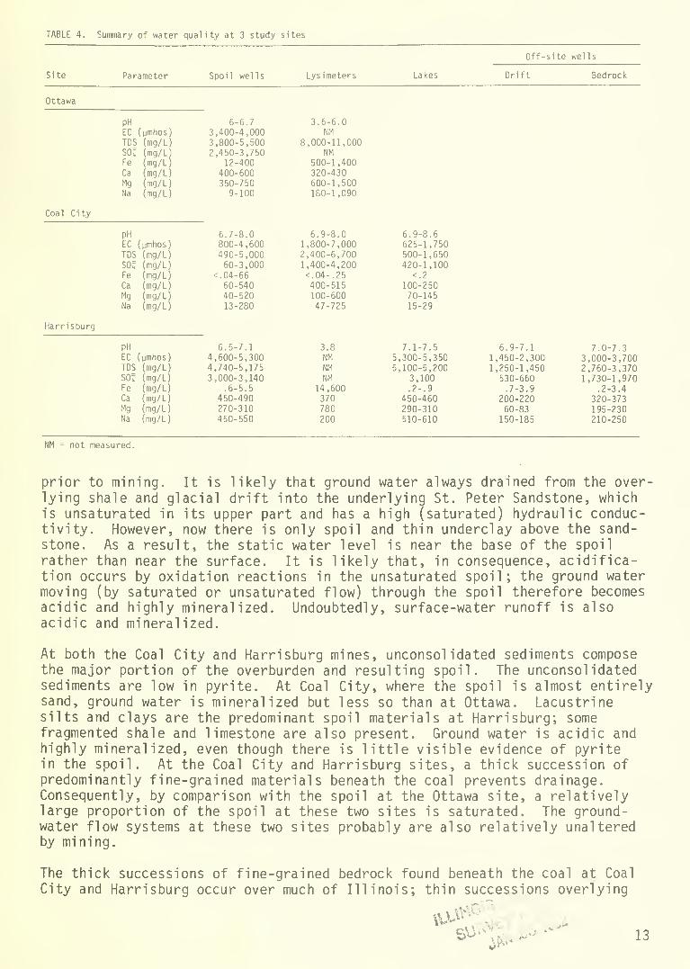
TABLE 4. Summary of water qual ity at 3 study sites
Parameter Spoil wells Lysimeters Lakes
Off-site wells
Site Drift Bedrock
Ottawa
PH 6-6.7 3.6-6.0EC (umhos) 3,400-4,000 NM
TDS (mg/L) 3,800-5,500 8,000-11,000SOU (mg/L 2,450-3,750 NMFe (mg/L) 12-400 500-1,400Ca (mg/L) 400-600 320-430Mg (mg/L) 350-750 600-1,500Na (mg/L) 9-100 180-1,090
Coa 1 C i ty
6.9-8.0 6.9-8.6PH 6.7-8.0EC (umhos) 800-4,600 1,800-7,000 625-1,750TDS (mg/L) 490-5,000 2,400-6,700 500-1,650SO? (mg/L) 60-3,000 1,400-4,200 420-1,100Fe (mg/L) <. 04-66 <.04-.25 <.2
Ca (mg/L) 60-540 400-515 100-250Mg (mg/L) 40-520 100-600 70-145
Na (mg/L) 13-280 47-725 15-29
Harrisburg
3.8 7.1-7.5 6.9-7.1PH 6.5-7.1 7.0-7.3EC (pmhos) 4,600-5,300 NM 5,300-5,350 1,450-2,300 3,000-3,700TDS (mg/L) 4,740-5,175 NM 5,100-5,200 1,250-1,450 2,760-3,370SO: (mg/L) 3,000-3,140 NM 3,100 530-660 1,730-1,970Fe (mg/L) .6-5.5 14,600 .2-.
9
.7-3.9 .2-3.4Ca (mg/L) 450-490 370 450-460 200-220 320-373Mg (mg/L) 270-310 780 290-310 60-83 195-230Na (mg/L) 450-550 200 510-610 150-185 210-250
NM = not measured.
prior to mining. It is likely that ground water always drained from the over-lying shale and glacial drift into the underlying St. Peter Sandstone, whichis unsaturated in its upper part and has a high (saturated) hydraulic conduc-tivity. However, now there is only spoil and thin underclay above the sand-
stone. As a result, the static water level is near the base of the spoil
rather than near the surface. It is likely that, in consequence, acidifica-tion occurs by oxidation reactions in the unsaturated spoil; the ground watermoving (by saturated or unsaturated flow) through the spoil therefore becomesacidic and highly mineralized. Undoubtedly, surface-water runoff is alsoacidic and mineralized.
At both the Coal City and Harrisburg mines, unconsolidated sediments composethe major portion of the overburden and resulting spoil. The unconsolidatedsediments are low in pyrite. At Coal City, where the spoil is almost entirelysand, ground water is mineralized but less so than at Ottawa. Lacustrinesilts and clays are the predominant spoil materials at Harrisburg; somefragmented shale and limestone are also present. Ground water is acidic andhighly mineralized, even though there is little visible evidence of pyritein the spoil. At the Coal City and Harrisburg sites, a thick succession ofpredominantly fine-grained materials beneath the coal prevents drainage.Consequently, by comparison with the spoil at the Ottawa site, a relativelylarge proportion of the spoil at these two sites is saturated. The ground-water flow systems at these two sites probably are also relatively unalteredby mining.
The thick successions of fine-grained bedrock found beneath the coal at Coal
City and Harrisburg occur over much of Illinois; thin successions overlying
Stf 13
more permeable rocks— such as are found at the Ottawa site—are much lesscommon. As compared with mining at sites like that at Ottawa, surface miningin much of Illinois should effect little change in the physical characteris-tics of ground-water flow systems.
The major effect of surface mining on ground water at all sites is deteriora-tion of water quality (data for the three sites are summarized in table 4).
Deterioration is obvious at Harrisburg, where surface water from the lake andground water from the monitoring wells in the spoil are more acidic andmineralized than ground water from wells in the undisturbed drift and bedrock.Although there is no information on ground-water quality for unmined portionsof the Ottawa and Coal City sites, ground water from the spoil is moremineralized than is usual for undisturbed overburden. The deterioration ofquality is due to interactions between spoil and ground water, some of whichare not fully understood. Where pyritic material is present on the surfaceand throughout the spoil, weathering of pyrite has produced acidic spoil;ground and surface waters are acidic and highly mineralized. Acidificationmay be enhanced at sites where a large proportion of the spoil is not saturatedwith water, as at Ottawa.
The three sites were mined prior to the enactment of reclamation laws in
Illinois. Reclamation of the sites, including proper handling of the pyriticmaterial to minimize oxidation, would probably have reduced adverse impacts onground and surface waters.
The work to date has demonstrated that the geology of any site must be under-stood if the impact of mining on geologic materials and ground water is to be
properly evaluated. Future work will include more detailed study of thephysical and chemical characteristics of ground-water flow systems. In addi-tion to research in and around abandoned mines, long-term studies are neededprior to, during, and subsequent to mining.
ACKNOWLEDGMENTS
The piezometers at the Ottawa site were installed as an auxiliary part of a
cooperative study between Paul B. DuMontelle (Engineering Geology Section ofthe Geological Survey) and the Illinois Department of Transportation, Divisionof Aeronautics. The piezometers at the Ottawa site and five at the Coal Citysite were drilled by the Ottawa District of the Division of Highways. SaharaCoal Company drilled the piezometers at the Harrisburg site. The lysimetersand all other piezometers were installed using the Survey drill with theassistance of Edward G. Scoggin. We also wish to thank Gould Trust of theFirst National Bank of Ottawa, owner of the Ottawa site, the Coal City AreaClub and Commonwealth-Edison Company, owners of the Coal City site, and SaharaCoal Company, owner of the Harrisburg site, for permission to install themonitoring networks on their land.
14
REFERENCES
Atherton, E., and J. E. Palmer, 1979, The Mississippian and Pennsylvanian(Carboniferous) Systems in the United States - Illinois, in The Missis-sippian and Pennsylvanian (Carboniferous) Systems in the United States:U.S. Geological Survey Professional Paper 1110-A-L; reprinted as IllinoisState Geological Survey Reprint 1979 H, 42 p.
Coal Section Staff, 1978, Illinois: description of coal seams, in 1978 Key-stone Coal Industry Manual: McGraw-Hill Book Company, New York, p. 478-
489; reprinted as Illinois State Geological Survey Reprint 1978 M.
Collier, C. R. , R. J. Pickering, and J. J. Musser, 1970, Influences of stripmining on the hydrologic environment of parts of Beaver Creek Basin,Kentucky, 1955-1966: U.S. Geological Survey Professional Paper 427-C, 80 p.
Culver, H. E., 1922, Geology and mineral resources of the Morris Quadrangle:Illinois State Geological Survey Bulletin 43-B, p. 95-204.
Frye, J. C. , A. B. Leonard, H. B. Willman, and H. D. Glass, 1972, Geology and
paleontology of late Pleistocene Lake Saline, southeastern Illinois:
Illinois State Geological Survey Circular 471, 44 p.
Haynes, R. J., and W. D. Klimstra, 1975a, Illinois lands surface mined forcoal: Southern Illinois University, Cooperative Wildlife Research Labora-tory, 201 p.
Haynes, R. J., and W. D. Klimstra, 1975b, Some properties of coal spoilbankand refuse materials resulting from surface-mining coal in Illinois:Illinois Institute of Environmental Quality, 126 p.
Mezga, L. J., 1973, Hydrology and water balance of a partially strip minedwatershed, WSD-19 of the Little Mill Creek Basin, Coshocton, Ohio, withemphasis on flow through spoil material: Kent State University, unpub-lished Master's thesis, 82 p.
Peterson, J. R. , and L. Papp-Vary, 1972, Soil and geological study of the Ful-ton County site prior to the application of fertilizer: MetropolitanSanitary District of Greater Chicago, unpublished research report, 17 p.
Pietz, R. I., J. R. Peterson, and C. Lue-Hing, 1974, Ground-water quality ata strip mine reclamation area in west-central Illinois: Second Researchand Applied Technology Symposium on Mined-Land Reclamation, Lexington,Kentucky.
Schubert, J. P., R. D. Olsen, and S. D. Zellmer, 1978, Monitoring the effectsof coal refuse disposal and reclamation on water quality in southwesternIllinois: Proceedings, Fourth Joint Conference on Sensing of Environ-mental Pollutants, p. 724-731.
Schubert, J. P., 1979, Ground-water contamination problems resulting from coalrefuse disposal: First International Mine Drainage Symposium, Denver,Colorado, 30 p.
15
Sendlein, L.V.A., and D. W. Stangl , 1977, Ground-water report— Iowa Coal
Project Demonstration Mine No. 1: Iowa State University, Energy andMineral Resources Research Institute, Report IS-ICP-58, 128 p.
Smith, W. H., 1957, Strippable coal reserves of Illinois: Part 1 - Gallatin,Hardin, Johnson, Pope, Saline, and Williamson Counties: Illinois StateGeological Survey Circular 228, 39 p.
Smith, W. H., 1968, Strippable coal reserves of Illinois: Part 6 - La Salle,Livingston, Grundy, Kankakee, Will, Putnam, and parts of Bureau andMarshall Counties: Illinois State Geological Survey Circular 419, 29 p.
Willman, H. G., and J. N. Payne, 1942, Geology and mineral resources of theMarseilles, Ottawa, and Streator Quadrangles: Illinois State GeologicalSurvey Bulletin 66, 388 p.
Willman, H. B., and others, 1967, Geologic Map of Illinois: 1:500,000:Illinois State Geological Survey.
16
APPENDIX: Logs of Borings
OTTAWA
Well #1
Well #2
Well #3
Lysimeters near 3
Well #4
Well #5
Well #6
0-2.1 m (0-7 ft) silty clay, 2.1-9.0 m (7-29.5 ft)weathered shale, 9.0-9.1 m (29.5-30 ft) silty clay till.No casing data available.
10 m (33 ft) deep. No log or casing data available.
0-9.9 m (0-32.5 ft) weathered shale, 9.9-10.4 m (32.5-34 ft) dense black coal, 10.4-11.3 m (34-37 ft) densesandy shale. No casing data available.
Three at depths of 8.1 m (24.5 ft), 5.9 m (19.5 ft), and2.8 m (9.3 ft).
12.2 m (40 ft) deep. No log or casing data available.
9.1 m (30 ft) deep. No log or casing data available.
0-12.2 m (0-40 ft) alternating layers (6) of silty clayand shale.
COAL CITY
Well #1
Lysimeters near 1
Well #2
Lysimeters near 2
Well #5
Well #6
Well #7
Well #8
0-13.7 m (0-45 ft) mostly medium- to coarse-grained sand,
with some clay layers and pebbly till layers. Coal lumpat 3.5 m (11.6 ft). Shale bedrock at 13.6 m (44.5 ft),
cased to bedrock.
Destroyed before any samples obtained, 2.7 m (9.1 ft) and
1.3 m (4.2 ft) deep.
0-18.6 m (0-61 ft) mostly medium- to coarse-grained sand,
with some clay layers, massive till layers, and thin coal
layers. Shale bedrock at 18.4 m (60.2 ft). No details oncasings given.
Depths of 2.8 m (9.3 ft) and 1.2 m (3.9 ft).
0-6.9 m (22.5 ft) fine to coarse sand, with coarsenessincreasing with depth, 6.9-8.2 m (22.5-27 ft) layers of
massive till, silty clay, and sandy silt, 8.2-8.4 m
(27-27.5 ft) weathered shale. Cased to top of weatheredshale.
0-8.1 m (0-26.5 ft) fine- to coarse-grained sand,
increasing in size with depth, 8.1-9.0 m (26.5-29.5 ft)
clay, 9.0-9.3 m (29.5-30.5 ft) shale. Cased to 7.95 m(26.0 ft).
0-13.7 m (0-45 ft) mostly layers of silty sand to werycoarse sand, also some layers of clay and clayey till,13.7-14.0 m (45-46 ft) black coal and shale. Cased nearlyto the base.
0-13.7 m (0-45 ft) silty sand to medium-grained sand witha gravel layer at 10.4 m (34 ft), 13.7-14.0 m (45-46 ft)
black coal and shale. Cased to 13.85 m (45.5 ft).
17
HARRISBURG
Well #1
Well #2
Lysimeters near 2
Well #3
Well #4
Well #5
Well #6
Lysimeters near 6
Well #7
0-11.0 (0-36 ft) clay, 11.0-12.8 m (36-42 ft) sand,
12.8-14.0 m (42-46 ft) gray shale, 14.0-16.5 m (46-54 ft)
sandstone, 16.5-19.8 m (54-65 ft) limestone, 19.8-20.4 m(65-67 ft) black slate, 20.4-20.7 m (67-68 ft) #6 Coal.Cased to 20.1 m (66 ft).
0-14.3 m (0-47 ft) virtually identical to well #1.
Finished in gray shale at 14.3 m (47 ft). No casingdata available.
Two at depths of 4.3 m (14 ft) and 2.4 m (8 ft).
0-12.2 m (0-40 ft) clay, 12.2-16.8 m (40-55 ft) sand,16.8-17.7 m (55-58 ft) gray shale and slate, 17.7-19.5 m(58-64 ft) limestone, 19.5-20.1 m (64-66 ft) #6 Coal.
Cased to 19.8 m (65 ft).
0-17.7 m (0-58 ft) essentially the same as well #3.
Finished in gray shale. Cased to 14.3 m (47 ft)
into sand.
0-3.0 m (0-10 ft) shale fragments, 3.0-7.6 m (10-25 ft)
silt to silty clay, 7.6-12.2 m (25-40 ft) gray shale,12.2-16.8 m (40-55 ft) silty clay to clayey silt,
16.8-18.3 m (55-60 ft) shale and limestone fragments,18.3-22.1 m (60-72.5 ft) silty clay to silt. No casingdata available.
0-1.5 m (0-5 ft) rock fragments, 1.5-3.0 m (5-10 ft) brown
clay with pebbles, 3.0-4.6 m (10-15 ft) silty clay, 4.6-
18.6 m (15-61 ft) no log, 18.6-18.0 m (61-62 ft) shale.
Cased to 18.6 m (61 ft).
Two at 4.5 m (15 ft) and 2.7 m (9 ft) deep.
62 ft deep, no log or casing data.
18


![Notes Hydrogeology[1]](https://img.pdfslide.us/doc/110x75/553cb15155034636568b4951/notes-hydrogeology1.jpg)