Embed Size (px)
Citation preview

30
ISSN: 0213-4497Depósito Legal: C - 1054 - 1984Imprime: TÓRCULO
PORTADA: Detalle de la pradera en la Pampa de Achala (República Argentina)
Supervisión del inglés: Ana Martelli
Cadernos del Laboratorio Xeolóxico de Laxe aparece referenciado en: Zentralblatt für Mineralogie; Index toScientific & Technical proceedings; ISI/ISTP&B; Índice Español de Ciencia y Tecnología (C.S.I.C.); NotasBibliográficas del Boletín del I.G.M.E.; PASCAL TEMA C.N..R.R.; GEO ABSTRACTS; GEO BASE;CURRENT BOOK CONTENTS.

Cadernos Lab. Xeolóxico de LaxeCoruña. 2005. Vol. 30, pp. 145-166
ISSN: 0213-4497
Hydrogeological study of A High MountainArea (Serra da Estrela, Central Portugal):
a multidisciplinary approach
Estudo hidrogeológico de uma área montanhosa(Serra da Estrela, Portugal central): uma abordagem
multidisciplinar
Abstract
The results of a preliminary hydrogeological study of the river Zêzere catchment upstream of Manteigas(Serra da Estrela Natural Park, Central Portugal) are presented. In this mountain region, different types ofgroundwater and surface water (used in several economic activities) occur. The methodology adopted in thisstudy emphasizes the way how Geology, Geomorphology, Geophysics, Geochemistry, Soil Science andHydrogeology contribute to the description of the hydrological phenomena taking place in the catchment,such as infiltration and aquifer recharge and groundwater flow and geochemistry — allowing to develop bet-ter hydrogeologic conceptual models. The hydrological modelling in course includes the use of the VISU-AL BALAN code, which is being coupled to a GIS. The hydrogeochemical techniques are highlighted aswell as its preliminary results concerning major and minor elements. The thermomineral water studyincludes the identification of the reservoir’s geologic material, the characterization of water-rock interactionand geothermometry.
Key words: Mountain areas, geotectonics, geomorphology, hydrogeology, management of hydricresources, hydrogeochemical techniques, Portugal Centre.
ESPINHA MARQUES, J.1; MARQUES, J.M.2; CHAMINÉ, H.I.3,9; AFONSO, M. J.3;CARREIRA, P.M.4; FONSECA, P.E.5; CABRAL, J5; MONTEIRO SANTOS, F.A.6;
VIEIRA, G.T.7; MORA, C.7, GOMES, A.8; TEIXEIRA, J.9; SAMPER, J.10; PISANI, B.J.10;AGUIAR, C.11; GONÇALVES, J.A.12; ALMEIDA, P.G.13; CAVALEIRO, V.13;
CARVALHO, J.M.3; SODRÉ BORGES, F.1; AIRES-BARROS, L.2 & ROCHA, F.T.9
(1) Dep. de Geologia (CGUP), Faculdade de Ciências da Universidade do Porto, Praça de Gomes Teixeira, 4099-002 Porto, Portugal (E-mail: [email protected]).(2) Dep. de Engenharia de Minas e Georrecursos, Instituto Superior Técnico (IST), Lisboa, Portugal.(3) Dep. de Engenharia Geotécnica, Instituto Superior de Engenharia do Porto (ISEP), Portugal.

Cadernos Lab. Xeolóxico de LaxeCoruña. 2005. Vol. 30, pp.
(4) Dep. de Química, Instituto Tecnológico e Nuclear (ITN), Sacavém, Portugal.(5) Dep. de Geologia, Faculdade de Ciências da Universidade de Lisboa (LATTEX), Portugal.(6) Dep. de Física, Faculdade de Ciências da Universidade de Lisboa (CGUL), Lisboa, Portugal.(7) Centro de Estudos Geográficos, Universidade de Lisboa, Portugal.(8) Dep. de Geografia, Faculdade de Letras da Universidade do Porto (GEDES), Portugal.(9) Centro de Minerais Industriais e Argilas, Dep. de Geociências, Universidade de Aveiro, Portugal.(10) Escuela Tecnica Superior de Ingenieros de Caminos, Canales y Puertos, Universidad de La Coruña, España.(11) Centro de Investigação da Montanha (CIMO), Escola Superior Agrária de Bragança, Instituto Politécnico de Bragança, Portugal.
(12) Dep. de Matemática Aplicada, Faculdade de Ciências da Universidade do Porto, Portugal.(13) Dep. de Engenharia Civil, Universidade da Beira Interior (CECUBI), Covilhã, Portugal.
145-166

CAD. LAB. XEOL. LAXE 30 (2005) Hydrogeological study 147
INTRODUCTION
This paper is strongly connected to one of themost crucial water-related research issues of thismillennium: “High Mountain Areas Hydrology”(AURELI, 2002). Special emphasis will be dedicat-ed on thermal (e.g., Caldas de Manteigas thermalwaters; CARVALHO, 1996) and non-thermalgroundwaters issuing in Serra da Estrela HighMountain area (Central Portugal). Surface water sys-tems will also be considered. The selected study areais located in the vicinity of a regional morphostruc-ture — Bragança–Vilariça–Manteigas fault zone[BVMFZ] — on the sector that intersects the cen-tral massif of Serra da Estrela.
The study area corresponds to the river Zêzeredrainage basin upstream of Manteigas village andpresents specific geomorphologic, climatic and geo-tectonic characteristics which certainly contribute tocontrol local thermal groundwaters recharge andcirculation. Besides the presence of important ther-mal water resources (allowing the installation of theCaldas de Manteigas Spa), the research area is char-acterised by the existence of other strategic ground-water resources (e.g., high quality drinking water forbottling and domestic use at Manteigas village)which seem to be also strongly dependent on geo-morphology (recharge areas) and geotectonics(active faults responsible for groundwater circula-tion). Surface water resources have been taken intoconsideration because of the basin’s contribution tothe storage at the Castelo do Bode large dam, themain source for Lisbon’s water supply.
A broad characterization of the hydrogeologicregime existing in the region is presented, in termsof its geotectonic, climatic and geomorphologicfeatures. Relevant aspects of the geophysical behav-iour of the BVMFZ, based on seismicity and mag-netotelluric studies, are reviewed. The hydrologicimportance of soils and land cover is also examined.
Preliminary hydrogeochemical results on thelocal surface waters and shallow and deep ground-waters will be presented and discussed. One of theearliest tasks consisted of the hydrogeologic inven-torying of surface and groundwater ocurrences.These waters were monitored for one hydrologicyear. During this period, two fieldwork campaignswere carried out. The hydrochemical results (majorand minor elements) were used to derive informa-tion on groundwater’s geochemical history, with a
special emphasis on surface water/groundwaterinteractions. Maximum subsurface temperaturesexperienced by Caldas de Manteigas thermal waterswill be recorded by two types of chemical geother-mometers. Such information will be extremely help-ful in geothermal resource evaluation, since it alsoreflects the depth of groundwater circulation, basedon an understanding of regional tectonics and geot-hermal gradients.
In order to address what is happening on theinterrelation between local surface waters (rechargewaters) and groundwaters, an integrated multidisci-plinary approach is being launched, under the scopeof the HIMOCATCH R&D Project “Role of HighMountain Areas in Catchment Water Resources,Northern/Central Portugal: Serra da Estrela and Serra doMarão case studies”.
GEOMORPHOLOGICAL AND CLIMA-TOLOGICAL BACKGROUND
The Serra da Estrela (Fig. 1) is part of theCordilheira Central, an ENE-WSW mountain rangethat crosses the Iberian Peninsula, and is the highestmountain in the Portuguese mainland. Associatedto a maximum altitude of 1993m a.m.s.l., thismountain shows particular climatic and geomor-phological characteristics that play an importantrole and impact on the local water cycle, and, partic-ularly, on the hydrogeological sub-cycle.
The Zêzere river catchment upstream of thevillage of Manteigas and its surroundings corre-
sponds to an area of ca. 28 km2 with an altituderanging from 875m a.m.s.l., at the streamflow gaugemeasurement weir of Manteigas, to 1993m a.m.s.l.,at the Torre summit. The relief of this sector ofSerra da Estrela is dominated by two major plateaus,separated by the NNE-SSW valley of the Zêzereriver (VIEIRA, 2004; VIEIRA et al. 2005): theTorre-Penhas Douradas plateau (1450-1993ma.m.s.l.), located in the western side, and the Alto daPedrice–Curral do Vento plateau (1450-1760ma.m.s.l.). These plateaus are composite, show flatsurfaces at distinct altitudes and present a few widevalleys. Late Pleistocene glacial landforms anddeposits are a distinctive feature of the Zêzerecatchment, since the majority of the plateau areawas glaciated during the Last Glacial Maximum (e.g.,DAVEAU et al. 1997, VIEIRA, 2004).

The Serra da Estrela climate (DAVEAU et al.,1997; VIEIRA & MORA, 1998; VIEIRA, 2004) isMediterranean with dry and warm summers; thewet season extends from October to May, with amean annual precipitation of ca. 2500mm in theTorre summit, while the plateaus show more than2000mm. The main precipitation control factorsseem to be the slope orientation and the altitude. Infact, the western side of the mountain presents alarger number of days with rainfall, but a slightlylower total amount than the eastern part, which inturn shows a smaller number of days with rain. Ageneral raise in the precipitation with the altitude isnoticeable. However, on a local scale, the distribu-tion of the precipitation is hard to interpret due toits relation to the behaviour of the air mass fluxesand to complex air divergence and convergencemechanisms controlled by the mountain morpholo-gy.
Monthly temperature averages (VIEIRA &MORA, 1998) from Penhas Douradas, LagoaComprida and Penhas da Saúde meteorological sta-tions reveal that Serra da Estrela is characterized bya simple thermal regime. The warmest month is Julyand the coldest is January. Mean annual air temper-atures are below 7ºC in most of the plateaus areaand, in the Torre vicinity, they may be as low as 4ºC.
The available data concerning snow precipita-tion are scarce and of poor quality. Nevertheless,the hydrologic importance of snow provides goodreasons for intensifying the research concerning thesnowfall and snow cover patterns. So far, the spatialand temporal irregularity of snow related phenom-ena has been referred in earlier studies (e.g.,ANDRADE et al., 1992; MORA & VIEIRA, 2004).Since the snowfall above 1700m a.m.s.l. may repre-sent a significant fraction of the annual precipita-tion, the aquifer recharge from snowmelt will beestimated through the use of isotopic methods andgeomathematical modelling.
GEOTECTONICAL, GEOPHYSICALAND HYDROGEOLOGICAL SETTING
The Serra da Estrela mountain is located in theCentral-Iberian Zone of the Iberian Massif(RIBEIRO et al., 1990). The geological conditionsrepresent an essential part of the hydrologic settingsince they impose some of the main features of thehydrogeologic systems (Fig. 2), such as the infiltra-
tion and aquifer recharge processes, the type offlow medium (porous vs. fractured), the type ofgroundwater flowpaths, or the hydrogeochemistry.
The main lithotypes occurring in the region are(fig. 3): i) Variscan granitic rocks; ii) Precambrian-Cambrian metasedimentary rocks; iii) alluvium andQuaternary glacial deposits. The most importantregional tectonic structure is the NNE-SSWBragança-Vilariça-Manteigas fault zone, which con-trols the thermomineral occurrences.
The Bragança-Vilariça-Manteigas left-lateralstrike-slip fault zone (BVMFZ) is one of the majorstructures of the late-Variscan fault system networkin NW Iberia (Fig. 1). Its reactivation duringCenozoic times by the alpine compressive tectonics,together with the reactivation of major ENE-WSWtrending reverse faults (such as the Seia-Lousãfault), originated the uplift of the Serra da EstrelaMountain as a horst in a pop-up structure(RIBEIRO et al., 1990). A left-lateral movementwith upthrusting of the eastern block towardsWNW can be put in evidence, representing the pre-dominant tectonic style of the reactivated BVMFZin Plio-Quaternary times; fault slip-rates rangingfrom 0.2 to 0.5 mm/year (see CABRAL, 1989,1995) for the Upper Pliocene to Quaternary tecton-ic activity.
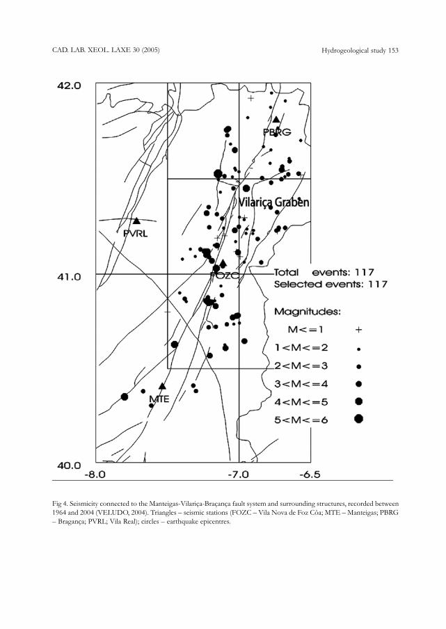
Instrumental seismicity associated to theBVMFZ demonstrates its present day activity (e.g.,RIBEIRO, 1984; MOREIRA, 1985; VELUDO,2004). It is presented here the location (Fig. 4) ofthe epicentres of several seismic events thatoccurred in the BVMFZ or in associated structures,between 1964 and 2004. The epicentres distributionindicates that whole segments of the BVMFZ areactive. The magnitude of the seismic events rangingfrom 1 to 6, demonstrate the variable seismic activ-ity in the area.
The BVMFZ has been the subject of geophys-ical studies in the last decades, which allowed a bet-ter characterisation of different tectonic structuresconnected to the BVMFZ. During 1996 and 1998,thirty magnetotelluric (MT) soundings were carriedout in the northern tip of the Vilariça basin (MON-TEIRO SANTOS et al., 2000, 2002). The interpre-tation of these data produced an image of the inter-nal electrical resistivity distribution of the basin (fig.5). The main characteristics of the MT models andthe interpretation of its features are as follows(MONTEIRO SANTOS et al., 2000): i) the upper-
CAD. LAB. XEOL. LAXE 30 (2005)148 Espinha Marques et al.

CAD. LAB. XEOL. LAXE 30 (2005) Hydrogeological study 149
most lithologies of the Parautochthonous show anaverage resistivity of 100-200 ohm m; ii) the transi-tion zone between Lower Allochthonous-Parautochthonous and the Parautochthonous isrepresented by a 350m thickness layer with a resis-tivity of 200-500 ohm m; iii) the Autochthonousmetasediments (dominated by quartzites, pelites andgraywackes), display distinct resistivity values, rang-ing from 500 to 4000 ohm m, defining different lay-ers; iv) the sedimentary filling of the tectonic basinis a good conductor, presenting average resistivitiesof 20-100 ohm m. The low resistivity of this zoneis mainly due to the water content of the sedimen-
Fig 1. Morphotectonic features from Central Portugal, Serra da Estrela mountain region. Major faults: PCTSZ – Porto-Coimbra-Tomar strike-slip shear zone; VCRFZ – Vigo-Vila Nova de Cerveira-Régua fault zone; VRPFZ – Verin-Régua-Penacova fault zone; BVMFZ – Bragança-Vilariça-Manteigas fault zone; SLFZ – Seia-Lousã fault zone.
tary units. The models suggest that this conductor isdeeper within the northeastern part of the basin,whose floor tilts towards the north and southwards;v) at depths of 2km, in the western part of the stud-ied area, the resistivity increases up to values greaterthan 4000 ohm m. We interpret the deepermost partof this layer as the Iberian gneiss basement; vi) theresistivity gradients revealed in the upper crust wereassociated with the main fault that controls the for-mation and evolution of the tectonic basin inQuaternary times.
The studies in course (e.g., ESPINHA MAR-QUES, in prep.; ALMEIDA, in prep.; AFONSO et

al., 2005) are taking into consideration the hydroge-ologic importance of the fracture network, withparticular emphasis on understanding the fault sys-tem geometry, the processes of opening and sealingof fractures, the stress fields and the seismic pump-ing occurrence. For this purpose, scale studies fromoutcrop to satellite imagery will be accomplished. Inparticular, remote sensing and tectonic analysis willbe used to characterise the main tectonic linea-ments. Data obtained from computational analysisof digital terrain models and from geological/geo-morphological structures are complemented byfield data acquired using traditional mapping meth-ods. Results will be integrated in a GeographicInformation System (GIS).
In order to understand groundwater’s rechargeand circulation related phenomena (particularlythermomineral waters), infiltration and rechargeareas are being identified and delimited by means ofhydrogeochemical, isotopic (MARQUES et al.,2005) and hydrogeomorphologic criteria. In addi-tion, groundwater circulation paths must be charac-terised and groundwater contribution to streamflowestimated. Thus, lithology, water chemistry, mor-phostructure, climate, soil type and land covershould altogether be considered.
An important issue connected to the infiltrationand aquifer recharge processes consists in the iden-tification of areas of prevailing fractured or porouscirculation mediums. In particular, the porous medi-ums are dominant in the alluvium and Quaternaryglacial deposits as well as in the most weatheredgranites and metasedimentary rocks. Porous medi-ums usually occur at shallower depths (typically lessthan 50m). On the other hand, fractured mediumsoccur in poorly weathered granitic or metasedimen-tary areas. Such mediums may be present very closeto the surface (especially on granitic outcrop domi-nated areas, with thin or absent sedimentary cover)or below the referred porous geologic materials.
INFILTRATION, SOILS AND LANDCOVER
Soils are especially relevant in hydrologic stud-ies, as they contribute to control both the volumeand the water chemistry in hydrologic systems. Theamount of water that moves from the topographicsurface into the soil or the rock masses — in other
words, that infiltrates — as consequence of a pre-cipitation event, directly influences the aquiferrecharge as well as the short-term stream response.The major factors usually pointed out as affectinginfiltration — and runoff — are the amount andcharacteristics of precipitation (or irrigation), thesoil physical and chemical features (e.g., saturatedhydraulic conductivity at the surface, clay mineralo-gy, presence of water-repellent substances), previ-ous soil water saturation, surface slope and rough-ness, land cover and amount of evapotranspiration(e.g., DINGMAN, 1994).
The soil features in this sector of Serra daEstrela result from the way how the formation fac-tors act. The soil system is described (JENNY,1994), by the following factors: parent material, cli-mate, topography, organisms and time. Humanaction is often referred as an additional item to beconsidered (e.g., GAUCHER 1981). The soil studyincluded several fieldwork campaigns carried outthrough 2004. During these campaigns, soil sampleswere collected (Fig. 6) in order to obtain a physical,chemical, geochemical and mineralogical characteri-sation.
The main soil physical properties considered inthe study are texture, structure, bulk density, particledensity, porosity, colour, water retention andhydraulic conductivity. Other properties consideredare pH, organic matter content, cation exchangecapacity and exchangeable cations. Soil mineralogyfocuses on clay mineralogy; soil geochemical analy-sis considered 36 chemical elements. The soilhydraulic conductivity was studied using the Guelphpermeameter field method. During 2004, around 50tests were conducted in most of the soil samplingsites.
The soil clay mineralogy and geochemistry isclosely related to a detrital origin (absolute predom-inance of quartz, mica/illite and feldspars; moresignificant values of Al, Fe and K). Nevertheless,some distinctive features are evident, such as: sam-ples related to granites show higher amounts ofphyllosilicates (but show a decrease in illite whereaskaolinite increases); samples showing more signifi-cant values of Al, Fe and K are those related togranites and to glacial deposits located on slopeand/or base of slope sites, whereas Ca shows high-er values in samples related to glacial deposits locat-ed on slope, base of slope and plateau sites(ROCHA et al., 2005).
CAD. LAB. XEOL. LAXE 30 (2005)150 Espinha Marques et al.

CAD. LAB. XEOL. LAXE 30 (2005) Hydrogeological study 151
Fig 2. Some aspects of the study area and the research work: a) Zêzere valley; b) Nave de Santo António, Cântaro Magroand Cântaro Gordo area; c) hydrochemical field analysis; d) snow cover at Nave de Santo António; e) soil profile in agranitic area; f) glacial deposit at Manteigas.

CAD. LAB. XEOL. LAXE 30 (2005)152 Espinha Marques et al.
Fig 3. Geological map of the Serra da Estrela region, Central Portugal (simplified after OLIVEIRA et al., 1992)
Land cover has an important impact on a num-ber of hydrological processes. The amount of infil-tration varies considerably depending on whethervegetation is or is not present and on vegetationtype. In the study region, several categories of landcover such as grassland, heathland, or forests aremore favourable for infiltration than granitic ormetasedimentary outcrop areas or exposed soils,mostly because of a runoff slowing effect.
It is included (Table 1) a preliminary descriptionof some hydrologically relevant soil system charac-teristics at each sampling site. Soil classificationaccording to the FAO-UNESCO criteria is beingproduced but is not yet available.
HYDROLOGICAL MODELLING
Hydrological models are being used to evaluatewater resources in the basin. These models, whichsolve the water balance equations in the upper soil,
the unsaturated zone and the aquifer, will provideestimates of aquifer recharge in the catchment. Forthis purpose, the computer code VISUAL BALANV2.0, developed at the University of A Coruña(ETSI), will be used (SAMPER et al. 1999, 2000,2005).
VISUAL BALAN V2.0 is a lumped hydrologiccode which solves the water balance equation in thesoil, the unsaturated zone and the aquifer. The coderequires only a few parameters and incorporatesuser-friendly interfaces for data input and post-pro-cessing of results. It evaluates hydrologic compo-nents in a sequential manner. In addition to thewater balance equation in the upper soil, the codealso solves the water balance equations in the unsat-urated zone and in the underlying aquifer. Thisallows the computation of daily groundwater levelsas well as basin water discharge rates. Computedheads and streamflows can be compared to meas-ured values for the purpose of model testing and
CAD. LAB. XEOL. LAXE 30 (2005) Hydrogeological study 153
Fig 4. Seismicity connected to the Manteigas-Vilariça-Braçança fault system and surrounding structures, recorded between1964 and 2004 (VELUDO, 2004). Triangles – seismic stations (FOZC – Vila Nova de Foz Côa; MTE – Manteigas; PBRG– Bragança; PVRL; Vila Real); circles – earthquake epicentres.

CAD. LAB. XEOL. LAXE 30 (2005)154 Espinha Marques et al.
Fig 5. 2-D resistivity model obtained from joint TE-TM mode data (apparent resistivities and phases) collected across theVilariça graben. The line marked with a b shows the approximate location of the basin (MONTEIRO SANTOS et al.,2000).
Table 1 — Main soil system characteristics of the studied area.

CAD. LAB. XEOL. LAXE 30 (2005) Hydrogeological study 155
Fig 6. Water and soil sampling points; major ion hydrogeochemical results.

calibration. VISUAL BALAN V2.0 accounts forirrigation sources and return flows. It also considerssnow precipitation, melting and runoff. Twoadvanced options have been incorporated recently:i) Automatic parameter estimation using groundwa-ter level and streamflow data and ii) Sensitivityanalyses of hydrologic components to modelparameters.
Since VISUAL BALAN V2.0 is a lumpedhydrologic model, it is more suited for homoge-neous and small basins. Therefore, as the studiedbasin is complex and exhibits a large spatial variabil-ity affecting most of its features, the basin is subdi-vided into several hydrologically homogeneous sub-basins where independent water balances can beperformed. Results of each sub-basin are subse-quently lumped to obtain the results for the wholebasin.
The hydrological model is based on tempera-ture and precipitation data from Penhas Douradasmeteorological station (1383m a.m.s.l.). The possi-bility of using auxiliary data from other stationssuch as that at Manteigas (815m a.m.s.l.) is open toconsideration. A preliminary definition of sub-basins, closely related to the definition of hydroge-omorphological units, is illustrated (Fig. 7). Severalcriteria are being considered in order to accuratelyrepresent the complexity of the hydrological sys-tem: geology, geomorphology, hydrogeology, cli-mate, soil type and land cover. During this delimita-tion process, special attention has been paid to theavailable geological and geomorphological maps(e.g., FERREIRA & VIEIRA 1999; VIEIRA, 2004).Due to the strong temperature and precipitationvertical gradients, climate data has to be analyzedcarefully. Preliminary model testing and calibrationhas been performed by comparing computedstreamflows to measured values from Manteigasstreamflow gauge station.
GEOGRAPHICAL INFORMATIONSYSTEM APPLICATION
Geographical Information System technologyis particularly appropriate for handling hydrogeo-logical data (SINGHAL & GUPTA, 1999). Thedevelopment of a GIS applied to this sector of
Serra da Estrela Natural Park will certainly help todevelop and improve conceptual models compris-ing the main components of hydrogeologic sys-tems, namely: i) recharge areas, ii) groundwater cir-culation zones and iii) discharge areas. Such anapproach is particularly suitable for handling a greatvariety of data that must be spatially integrated in acoherent manner (Fig. 8) which, as referred earlier,is the case of the study area.
The methodological framework followed in thisresearch offers important benefits for regionalwater resources management, especially in whatconcerns to groundwater exploration, to the defini-tion of well-head protection areas and to the assess-ment of aquifer pollution vulnerability.
VISUAL BALAN V2.0 has recently been cou-pled to a GIS (SAMPER et al., 2005). This proce-dure was carried out by extending the capabilities ofthe original code. For that purpose, a pre-processorhas been developed as an input interface to VISU-AL BALAN V2.0. Beginning from a digital eleva-tion model and using the geomorphologic data inthe GIS the pre-processor interprets model inputdata: sub-basin delineation, drainage network, mor-phologic parameters (average slope, characteristics,soil type and land cover/land use). Additionalimprovements are expected to be able to performmodelling of complex basins considering the spatialvariation of model parameters (distributed parame-ter model) and surface runoff propagation. GIS willprovide average parameter values for each sub-basindelineated by the pre-processor in the first step.Available meteorological data from different sta-tions will be processed in the GIS to create mapsthat describe the spatial variability of weather vari-ables. This information will be then processed toobtain series of average values for each sub-basin,in the same way as morphologic parameters.Connectivity between sub-basins will be establishedand so flow accumulation will be calculated for eachsub-basin. A further step is planned in the future tobe able to apply the balance equations to smallerareas, taking full advantage of the capabilities of theGIS.
CAD. LAB. XEOL. LAXE 30 (2005)156 Espinha Marques et al.

CAD. LAB. XEOL. LAXE 30 (2005) Hydrogeological study 157
HYDROGEOCHEMICAL APPROACH
Surface manifestations of thermomineralwaters circulation are a subject of great scientificand economic interest. Thermomineral waters andshallow cold groundwaters spurting out in the samearea should be observed and studied in detail, asthey provide a significant amount of information atrelatively low costs. This information may be usedin the appraisal of the thermomineral water
Fig 7. Sub-basin limits: 1 – Eastern plateau; 2 – Zêzere valley eastern slopes; 3 – Lower Zêzere valley floor; 4 – Nave deSanto António col; 5 – Upper Zêzere valley floor; 6 –Zêzere valley western slopes; 7 – Cântaros slopes; 8 – Lower westernplateau; 9 – Upper western plateau.
resources of a potential area for development.In the present chapter, some of the geochemi-
cal techniques employed in thermomineral waterinvestigations in the Caldas de Manteigas area, inorder to update local and/or regional conceptualcirculation models, are outlined. Preliminary resultson the major and minor element composition oflocal surface waters and of shallow and deepgroundwaters will be presented and discussed.
The hydrogeochemical study in course illus-

trates the considerable number of ground and sur-face water types coexisting in a relatively restrictedarea, thus reflecting the hydrologic complexity ofthe basin.
In order to embrace the various hydrologic sub-systems occurring in the region, three main watercategories were considered: i) shallow cold ground-waters; ii) deep thermomineral groundwaters andiii) surface waters from the river Zêzere and its trib-utaries.
A hydrogeologic inventory and the definition ofa network of surface and ground water monitoringpoints (springs, boreholes and streams) was carriedout (Fig. 6). Subsequent fieldwork campaigns wereconducted in September 2003 and April 2004 inorder to collect water samples for chemical and iso-topic (oxygen-18, deuterium and tritium) analysis.The resulting hydrogeochemical information (majorand minor element composition) is being applied toestimate geochemical evolution of groundwater,including its origin and interaction between waterand the aquifer rock minerals.
Temperature (ºC), pH and electrical conductivi-ty (ìS/cm) of the waters were determined in thefield. Total alkalinity was measured a few hours after
CAD. LAB. XEOL. LAXE 30 (2005)158 Espinha Marques et al.
Fig 8. Data integration in a GIS (modified after SINGHAL & GUPTA, 1999).
collection. The following methods were applied forchemical analyses performed at the Laboratório deMineralogia e Petrologia of Instituto SuperiorTécnico (LAMPIST, Lisbon): atomic absorptionspectrometry for Ca and Mg; emission spectrometryfor Na, K, Li, Rb and Cs; colorimetric methods forSiO2, Fetotal, F and Al; ion chromatography for
SO4, NO3 and Cl; potentiometry for alkalinity, here
referred to as HCO3. Representative data of the
waters sampled during the 1st (September 2003)
and 2nd (April 2004) fieldwork campaigns are pre-sented (tables 2 and 3).
At Caldas de Manteigas area, the thermominer-al waters (with output temperatures around 45ºC)are characterised by the following main features:
i) relatively high pH values ( ∼ 9).ii) TDS values usually in the range of 160 to170 mg/L.iii) HCO3 is the dominant anion.
iv) Na is the dominant cation.v) the presence of reduced species of sulphur
(HS- ? 1.7 mg/L).vi) high silica values (usually around 50 mg/L)
∼∼
∼∼

CAD. LAB. XEOL. LAXE 30 (2005) Hydrogeological study 159
representing a considerable percentage oftotal mineralization.vii) high fluoride concentrations (up to 7mg/L).
As indicated by the chemical composition ofthe Caldas de Manteigas thermomineral waters, thereservoir rock should be mainly granite, being thethermomineral waters mineralization strongly dom-inated by the hydrolysis of plagioclases. The strongHCO3-Na signatures of Caldas de Manteigas ther-
momineral waters can be clearly seen in the Stiffdiagram (Fig. 6).
Concerning the non-thermal waters sampled inthe studied region (surface waters and shallowgroundwaters), two groups can be defined throughthe geochemical signatures derived from the Stiffand Piper diagrams (Figs 6 and 9), namely:
- Group I) This first group encloses the so-called “normal” surface (Zêzere river – sam-pling point close to the Caldas de Manteigasspas) and shallow groundwaters (Covão do Boi,Jonja, Paulo Luís Martins, Bisa and N. Srª. deFátima spring waters). All of these watersbelong mainly to the HCO3-Na facies (a relative-
ly higher Ca concentration was found only inBisa spring during the field work campaign ofSeptember 2003), displaying different total dis-solved solids (TDS) values. The lower mineral-ization found in Zêzere river and Covão do Boi,Jonja and Paulo Luís Martins spring watersreflects low water-rock interaction associatedwith short surface/underground circulationpaths. These spring waters could be consideredas good signatures of local recharge. The rela-tively higher mineralization detected in Bisa andN. Srª. de Fátima spring waters could beascribed to long shallow underground flowpath, allowing higher water-rock interaction. Itshould be stated that Bisa spring is located in aforestated area where soils are enriched inorganic matter. This important source of addi-tional CO2 could be responsible for a higher
water-rock interaction, expressed in the follow-ing equation:
2NaAlSi3O8 + 9H2O + 2H+ + 2HCO3- =
Si2O5Al2(OH)4 + 2Na+ + 2HCO3- + 4
H4SiO4
The role of CO2 is strongly related with the pHof the solution since 2H+ + 2HCO3
- is, in fact,2H2CO3, or 2CO2 + H2O.
- Group II) This second group of watersencloses surface (Zêzere river – sampling pointsclose to Covão da Ametade and Jonja stream)and shallow groundwaters (Nave de StºAntónio and Espinhaço de Cão spring waters).This group of waters is also characterized byrelatively low mineralization, but presents clearNa-Cl geochemical signatures. The Na-Cl faciesfound within some of the waters of this groupcould be ascribed to the local use of NaCl topromote snowmelt in the roads during theWinter season. These geochemical signaturescan be clearly seen in the Piper diagram (see Fig.9). In the case of Espinhaço de Cão spring therather different Stiff diagrams indicates thatwater chemistry could be strongly controlled byother sources of anthropogenic contaminationrather than the local use of NaCl for snowmelting, since there are important differences in
the Na/Cl ratios from the 1st to the 2nd fieldwork campaign. The different geochemical sig-natures found in Espinhaço de Cão spring canbe clearly detected in the field through the high-er electric conductivity values (see Tables 2 and 3).
Chemical geothermometry is one of the mostimportant geohydrologic tools in the exploration ofthermomineral water resources. The main objectiveof geothermometric interpretation is to use thechemistry of hot springs in order to estimate chem-ical and physical properties of the reservoir fluid.This methodology depends upon the temperaturedependence of the concentrations of certainspecies, the chemical equilibrium between mineralsand water and various chemical reactions. Duringthe last two decades many chemical geothermome-ters have been proposed, both qualitative and quan-titative. Those used in this paper include the chal-cedony and quartz geothermometers (FOURNIER& TRUESDELL, 1974 in: FOURNIER, 1977;TRUESDELL, 1975 – cooling by conduction), thefeldspar (Na/K) geothermometer (WHITE &ELLIS, 1970 in: TRUESDELL, 1975) and the
K2/Mg geothermometer (GIGGENBACH, 1988).The results obtained are presented (see Table 4).
Bearing in mind that the reservoir fluid may

CAD. LAB. XEOL. LAXE 30 (2005)160 Espinha Marques et al.

CAD. LAB. XEOL. LAXE 30 (2005) Hydrogeological study 161
Fig 9. Major ion hydrogeochemistry: a) September 2003 campaign; b) April 2004 campaign.

become mixed with cold groundwater at shallowlevels and could change its chemistry by leachingand reaction with wall rocks on the way to the sur-face, the results obtained from the application ofseveral chemical geothermometers should be inter-preted with great caution. In the near future, theresults of chemical geothermometry will be corre-lated with the results from the geophysical and geo-tectonical surveys that will be performed in theregion, under the scope of the HIMOCATCHR&D Project. Such information will be extremelyhelpful in thermomineral water resources evalua-tion, since it also reflects the depth of groundwatercirculation, based on an understanding of regionaltectonics and geothermal gradients.
Using reservoir temperatures given by thequartz geothermometer (applied to Caldas deManteigas AC2 and AC3 borehole waters), and con-sidering a mean geothermal gradient of 30ºC/km,we can estimate a maximum depth of about 3.2kmreached by the Caldas de Manteigas thermomineralwater system. This value was obtained consideringthat:
depth = (Tr - Ta) / gg = (100 - 5) / 30 = 3.2
km
where Tr is the reservoir temperature (ºC), Tathe mean annual temperature (ºC) and gg the geot-hermal gradient.
Geochemical data of Fonte Santa thermalspring waters seems to corroborate a mixingprocess with local shallow groundwaters. This trendrequires the shallow groundwaters diluting FonteSanta thermal spring waters to be derived from localinfiltration. The mixing process should be responsi-ble for the higher Ca and Mg dissolution.Effectively, the Ca and Mg concentrations are lowerin AC2 and AC3 thermal borehole waters, whereasthese metals are higher in Fonte Santa thermalspring waters. Furthermore, Ca and Mg are veryoften added to cooled waters by a reaction with therock, as stated by several authors, particularly withregard to waters of the French Massif Central (e.g.,MICHARD et al., 1978, 1981; CRIAUD & FOUIL-LAC, 1986). Further fieldwork campaigns will clari-fy the above mentioned hypothesis, based on sys-
tematic isotopic (18O and 2H) signatures of thewaters.
In future studies involving the interpretation ofchemical geothermometry special emphasis will beput on the evaluation of the overall chemical char-acteristics of the waters, as they correlate to equilib-rium with alteration minerals.
CONCLUDING REMARKS
Crystalline rocks, particularly granites andmetasedimentary units, dominate the Serra daEstrela Mountain region. The hydrogeological char-acterisation of this kind of hard-rocks is complex,due to the high heterogeneity and anisotropy of thefracture network that stores and conducts the water.It is usual to consider that the flowpaths are mainlygoverned by the fissured medium hydraulic conduc-tivity, faulting and weathering, resulting on non-continuous productive zones. Nevertheless, it isclear that in the Variscan Iberian Massif, lithologyand structure play a major role on the productivityof regional hydrogeological units and related waterwells.
Some differences detected in local shallow coldgroundwater’s characteristics could be the result ofwater circulation paths varying in length and resi-dence time and/or anthropogenic contamination,such as the local use of NaCl for snow melting. Thecombined chemical and isotopic data suggests thatthe Caldas de Manteigas thermomineral waterscould be derived from regional groundwatersources. The quartz geothermometer indicatesreservoir temperatures of approximately 100ºC.
Combining information ascribed to the geo-chemical and isotopic signatures of groundwaters,hydrogeologists can strongly support their conclu-sions on the origin of waters and recharge areas,groundwater quality and contaminant processes,water-rock interactions occurring at depth andresource renewability.
ACKNOWLEDGEMENTS
In order to address the specific scientific issueson what is happening about the interrelation
CAD. LAB. XEOL. LAXE 30 (2005)162 Espinha Marques et al.

CAD. LAB. XEOL. LAXE 30 (2005) Hydrogeological study 163
between local surface waters (recharge waters) andgroundwaters, an integrated multidisciplinaryapproach is being launched under the scope of theHIMOCATCH Project “Role of High Mountain Areasin Catchment Water Resources, Northern/CentralPortugal”, granted by the Portuguese Foundation forScience and Technology (FCT), contract Nr.POCTI/CTA/44235/2002. PEF and JC acknowl-
Table 4 - Reservoir temperatures (ºC) of Caldas de Manteigas thermomineral waters, estimated from chemicalgeothermometry.
edge to Geodyn – Present to Past POCTI-ISFL-5-32. The authors acknowledge Prof. L. C. GamaPereira (Coimbra) for detailed reviews that helpedto improve the clarity of the manuscript.
Recibido:9/5/2005Aceptado:24/6/2005

REFERENCES
AFONSO, M. J.; ESPINHA MARQUES, J.; MAR-QUES, J. M.; CARREIRA, P.; CARVALHO, J.M.; MARQUES DA SILVA, M.; SAMPER, J.;BORGES, F. S.; ROCHA, F. T.; FONSECA, P.E.; GOMES, A.; ARAÚJO, M. A.; TELESVIEIRA, G.; MORA, C.; TEIXEIRA, J.;ALMEIDA, P. G. & CHAMINÉ, H. I. (2005).Hydrogeology of hard-rocks from two key-sec-tors in the Portuguese Iberian Massif: examplesfrom Porto urban area and Serra da Estrelamountain region. Proceedings Water in CelticCountries: Quantity, Quality and Climate Variability,“The Fourth Inter-Celtic Colloquium on Hydrology andManagement of Water Resources”, Univ. Minho,Guimarães. (in press)
ALMEIDA, P. G. (in prep.). Estudo tectonoestrutural ecaracterização geotécnica do maciço granítico Central daSerra da Estrela. Um exemplo da utilização multidis-ciplinar numa abordagem holística da Geologia. UBI,Covilhã (PhD Thesis, in preparation).
ANDRADE, E.; MORA, C.; NEVES, M. & VIE-IRA, G. (1992). Desportos de Inverno na Serrada Estrela. Contribuição para o estudo da suaviabilidade. Finisterra, Lisboa, 27 (53-54): 187-193.
AURELI, A. (2002). What’s ahead in UNESCO’sInternational Hydrological Programme (IHP VI2002-2007). Hydrogeology Journal, 10: 349-350.
CABRAL, J. (1989). An example of intraplate neo-tectonic activity, Vilariça Basin, NortheastPortugal. Tectonics, 8: 285303.
CABRAL, J. (1995). Neotectónica em PortugalContinental. Memórias do Instituto Geológicoe Mineiro, Memória 31, Lisbon, 265 pp.
CARVALHO, J. M. (1996). Mineral water explora-tion and exploitation at the PortugueseHercynian massif. Environmental Geology, 27: 252-258.
CRIAUD, A. & FOUILLAC, C. (1986). Étude deseaux thermominérales carbogazeuses du MassifCentral Français. II. Comportement de quel-ques métaux en trace, de l’arsenic, del’antimoine et du germanium. Geochim.Cosmochim. Acta, 50: 1573-1582.
DAVEAU, S.; FERREIRA, A. B.; FERREIRA, N.& VIEIRA, G. (1997). Novas observações acer-
ca da glaciação da Serra da Estrela. Estudos doQuaternário, Lisboa, 1: 41-51.
DINGMAN, S. L. (1994). Physical hydrology. PrenticeHall, New Jersey, 575 pp.
ESPINHA MARQUES, J. M. (in prep.). Contribuiçãopara o conhecimento da hidrogeologia da região doParque Natural da Serra da Estrela (sector deManteigas–Nave de Sto. António–Torre).Universidade do Porto (PhD Thesis, in prepara-tion).
FERREIRA, N. & VIEIRA, G. (1999). Guiageológico e geomorfológico do Parque Naturalda Serra da Estrela. Locais de interesse geológi-co e geomorfológico. Parque Natural da Serrada Estrela. Edição Instituto da Conservação daNatureza/Instituto Geológico e Mineiro,Lisboa. 112 pp., 2 mapas.
FOURNIER, R. O. (1977). Chemical geothermo-meters and mixing models for geothermal sys-tems. Geothermics, 5: 41-50.
GAUCHER, G. (1981). Les facteurs de la pédogénèse. G.Delotte, Dison, 730pp.
GIGGENBACH, W. F. (1988). Geothermal soluteequilibria: derivation of Na-K-Ca-Mg geoindi-cators. Geochim. Cosmochim. Acta, 52: 2749-2765.
JENNY, H. (1994). Factors of soil formation, a system ofquantitative pedology. Dover Publications, Inc..New York, 281pp..
MARQUES, J. M.; CARREIRA, P. M.; ESPINHAMARQUES, J. M.; CHAMINÉ, H. I.; FON-SECA, P. E.; MARTINS CARVALHO, J. &CAVALEIRO, V. (2005) Pattern and spatialextent of thermal water flow in a high moun-tain area (Serra da Estrela, Central Portugal): a
preliminary isotopic approach. Abstract, 6th
International Symposium on Applied IsotopeGeochemistry, 11-16 September 2005, Prague,Czech Republic. (submitted)
MICHARD, G.; EVRARD, M.; FOUILLAC, C. &LAMBRET, B. (1978). Acquisition des ionsalcalino terreux par les eaux carbogazeuses.Earth Planet. Sci. Lett., 41: 170-174.
MICHARD, G.; FOUILLAC, C.; GRIMAUD, D. &DENIS, J. (1981). Une méthode globale d’esti-mation des températures des réservoirsalimentant les sources thermales. Exemple duMassif Central Français. Geochim. Cosmochim.Acta, 45: 1199-1207.
MONTEIRO SANTOS, F. A.; ALMEIDA, E.;
CAD. LAB. XEOL. LAXE 30 (2005)164 Espinha Marques et al.

CAD. LAB. XEOL. LAXE 30 (2005) Hydrogeological study 165
MATEUS, A.; MATIAS, H.; MATOS, L. &MENDES-VICTOR, L. A. (2000).Magnetotelluric study of a Plio-Quaternary tec-tonic depression: the Vilariça basin (NEPortugal). Journal of Applied Geophysics, 44, 1-14.
MONTEIRO SANTOS, F. A.; MATOS, L.;ALMEIDA, E.; MATIAS, H.; MATEUS, A. &MENDES-VICTOR, L. A. (2002). Three-dimensional magnetotelluric modelling of theVilariça depression (NE Portugal). Journal ofApplied Geophysics, 49: 59-74.
MORA, C. & VIEIRA, G. T. (2004). Balance radi-activo de los altiplanos de la Sierra de Estrella(Portugal) en una mañana de invierno.Metodología y primeros resultados. Bol. R. Soc.Esp. Hist. Nat. (Sec. Geol.), Madrid, 99 (1-4): 37-45.
MOREIRA, V. S. (1985). Sismotectonics ofPortugal and its adjacent areas in the Atlantic.Tectonophysics, 117: 85-96.
OLIVEIRA, J. T.; PEREIRA, E.; RAMALHO, M.;ANTUNES, M. T. & MONTEIRO, J. H.[coords.] (1992). Carta Geológica de Portugal escala1/500000, 5ª edição. Serviços Geológicos dePortugal, Lisbon.
RIBEIRO, A. (1984). Neotectonique du Portugal. Livrode Homenagem a Orlando Ribeiro, 1º Vol.,Centro de Estudos Geográficos, Univ. Lisboa,173-182.
RIBEIRO, A.; KULLBERG, M. C.; KULLBERG, J.C.; MANUPPELLA, G. & PHIPPS, S. (1990).A review of Alpine tectonics in Portugal: fore-land detachment in basement and cover rocks.Tectonophysics, 184: 357-366.
ROCHA, F.; INÁCIO, M.; ESPINHA MARQUES,J.; GONÇALVES, P.; AGUIAR, C. &CHAMINÉ, H. I. (2005). Clay mineralogy andgeochemistry of soils from Serra da EstrelaNatural Park (Central Portugal): preliminaryresults. Proceedings do VIII Congresso de Geoquímicados Países de Língua Portuguesa, Universidade deAveiro. (in press).
SAMPER, J.; HUGET, L.; ARÉS, J. & GARCÍA, M.A. (1999). Manual del usuario del programaVisual Balan V.1.0. Publicación Técnica de ENRE-SA, 5 (99): 1-132.
SAMPER, J.; GARCÍA VERA, M. A.; PISANI, B.;VARELA, A.; LOSADA, J. A.; ALVARES, D. &ESPINHA MARQUES, J. (2005). Usin g hydro-
logic models and Geographic InformationSystems for water resources evaluation: GIS-VISUAL-BALAN and its application toAtlantic basins in Spain (Valiñas) and Portugal(Serra da Estrela). Proceedings The Fourth Inter-Celtic Colloquium on Hydrology and Management ofWater Resources, Universidade do Minho,Guimarães. (in press).
SAMPER, J.; HUGET, L.; ARÉS, J. & GARCÍA, M.A. (2000). Modelos interactivos de balancehidrológico: aplicación a cuencas de Galicia. In:SAMPER, J.; LEITÃO, T.; FERNÁNDEZ, L.& RIBEIRO, L. (eds.), Jornadas Hispano-Lusassobre ‘Las Aguas Subterráneas en el Noroestede la Península Ibérica’. Textos de las Jornadas,Mesa Redonda y Comunicaciones. A Coruña.AIH-Grupo Español & APRH. PublicacionesITGE, Madrid. pp. 211-219.
SINGHAL, B. B. S. & GUPTA, R. P. (1999). Appliedhydrogeology of fractured rocks. Kluwer AcademicPublishers, Dordrecht, 400 pp.
TRUESDELL, A. H. (1975). Summary of SectionIII. Geochemical techniques in exploration.Proc. Second United Nations Symposium on theDevelopment and Use of Geothermal Resources. SanFrancisco, California. Edited by LawrenceBerkley Laboratory, University of California:53-79.
VELUDO, I. (2004). Monitorização da actividadesísmica no território do parque arqueológico do vale doCôa. Relatório de Estágio. Fac.Ciências Univ.Lisboa. (Relatório Inédito)
VIEIRA, G. T. & MORA, C. (1998). General char-acteristics of the climate of the Serra da Estrela.In: VIEIRA, G.T. (ed.), Glacial and PeriglacialGeomorphology of the Serra da Estrela. Guidebook forthe field-trip, IGU Commission on Climate Change andPeriglacial Environments. CEG and Department ofGeography, University of Lisbon, pp. 26-36.
VIEIRA, G. T. (2004). Geomorfologia dos planaltos ealtos vales da Serra da Estrela. Ambientes frios doPlistocénico Superior e dinâmica actual. Universidadede Lisboa, 724p. + 1 mapa. (PhD Thesis).
VIEIRA, G. T.; JANSEN, J. & FERREIRA, N. (sub-mitted). Environmental setting of the Serra daEstrela, Portugal: a short-note. In: BUNCE, R.,HOWARD, D. & PINTO CORREIA, T. (eds.),Landscape ecology series, IALE UK.


![Trans-Serra da Estrela Trekking Expedition [ February 2013 ]](https://img.pdfslide.us/doc/110x75/568c34331a28ab02358f8ef2/trans-serra-da-estrela-trekking-expedition-february-2013-.jpg)