Embed Size (px)
Citation preview

HYDROGEOLOGIC REPORT
OF THE
PENNSYLVANlAN MINOR GROUNDWATER BASIN
AND THE
ASHLAND ISOLATED TERRACE GROUNDWATER BASIN
IN
COAL, PITTSBURG AND HASKELL COUNTIES
byKent Wilkins
OKLAHOMA WATER RESOURCES BOARDWater Management Division
January 1997

ACKNOWLEDGEMENTS
The author is grateful to Mark Belden, Noel Osborn and Robert Fabian in the Planning andManagement Division for their technical support and review ofthe report.
Appreciation is also extended to James Leewright and Mike McGaugh of our Mapping and DraftingSection of the Administrative Services Division for the drafting of the figures in the report; LouKlaver, Assistant Chief of the Planning and Management Division for her legal review of thedocument; and Mary Whitlow and Susan Birchfield for their review and editing of the report forfinal preparation for publication.
This publication is prepared, issued and printed by the Oklahoma Water Resources Board.75 copies have been prepared at a cost of $189.00.

INTRODUCTION
PHYSICAL SETTINGLocationSettingClimateRegional Geology
GROUNDWATER RESOURCESPennsylvanian Minor Groundwater Basin
Aquifer ParametersAquifer Storage and Yield CapabilitiesWater Use .Prior Groundwater Rights
Ashland Isolated Terrace Groundwater BasinAquifer ParametersAquifer Storage and Yield CapabilitiesWater Use .Prior Groundwater Rights
GROUNDWATER QUALITY .Pennsylvanian Minor Groundwater BasinAshland Isolated Terrace Groundwater Basin
SUMMARY .Pennsylvanian Minor Groundwater BasinAshland Isolated Terrace Groundwater Basin
REFERENCES
GLOSSARY
1
22224
55567788
101010
111112
141414
15
17

INTRODUCTION
The hydrogeologic report of the minor groundwater basins in Coal, Pittsburg, and Haskell Countieswas conducted by the Oklahoma Water Resources Board (Board) under the authority ofOklahomaStatutes Title 82, Sections 1020.4 and 1020.5. Section 1020.4 authorizes the Board to conducthydrologic surveys and investigations of fresh groundwater basins to characterize the availability,extent and natural hydrologic conditions of the resource. The Board is further directed by Section1020.5, upon completion of the hydrologic survey, to determine the maximum annual yield of freshwater to be produced from each groundwater basin as well as the equal proportionate share of themaximum annual yield to be allocated to each acre of land overlying the basin(s). Thisdetermination is to be based on the following criteria:
I) The total land area overlying the basin or subbasin;2) The amount of water in storage in the basin or subbasin;3) The rate ofrecharge to the basin or subbasin and total discharge from the basin or subbasin;4) Transmissivity of the basin or subbasin; and5) The possibility of pollution of the basin or subbasin from natural sources.
The maximum annual yield determination and equal proportionate share results are subject of anaccompanying report.
The purpose of this report is to review, assess, and evaluate hydrologic data pertaining to thegroundwater resources in the study area. Data sources include records maintained by the Board,existing hydrogeologic reports and references which assess the study area and hydrologic reportsor texts which evaluate hydrogeologic settings similar to the study area. In some instances, fieldmeasurements may be made to provide support for certain assumptions or estimates about aparticular parameter.
This report will provide the hydrologic data necessary to determine or estimate the above criteriawhich will provide the basis for determining the maximum annual yield and equal proportionateshare of the minor groundwater basins within the study area. The maximum annual yielddetermination and equal proportionate share results are subject of an accompanying report.
A minor groundwater basin is defined as a distinct underground body of water overlain bycontiguous land and having substantially the same geological and hydrological characteristics andfrom which the groundwater wells yield less than 50 gallons per minute on the average basinwideif from a bedrock basin and 150 gallons per minute if from an alluvial and terrace basin.
Both a minor bedrock groundwater basin and a minor terrace groundwater basin were identifiedwithin the study area. The bedrock basin is named the Pennsylvanian Minor Groundwater Basin(PMGB) and the alluvial and terrace basin is named the Ashland Isolated Terrace GroundwaterBasin (AITGB).
1

PHYSICAL SETTING
Location
This report will be limited to Coal, Pittsburg, and Haskell counties located in southeasternOklahoma. The three counties contain approximately 1,573,120 acres. The counties were selectedfor this report on the basis of similar groundwater resources and geologic deposits. The principalgroundwater basin for this study is comprised primarily of Pennsylvanian aged rocks with someminor areas of Mississippian, Silurian, Devonian, Ordovician and alluvium and terrace deposits.Also included as a separate basin is an isolated Quaternary terrace deposit in southwestern PittsburgCounty and northeastern Coal County.
The alluvium and terrace deposits, associated with the Canadian and Arkansas River systems alongthe northern borders of Pittsburg and Haskell Counties, are potential major basins and will not beconsidered in this report. Also excluded from this report is an area in southwestern Coal Countyunderlain by the Simpson Formation which is a major bedrock groundwater basin. Figure I showsthe limits of the study area.
Setting
The land encompassed within the study area consists primarily of wooded areas and prairies.Topographic differences range from 460 feet above sea level along the Arkansas River innortheastern Haskell County to approximately 1600 feet above sea level in southeastern HaskellCounty.
The topography is the expression of the structure and stratigraphy through erosion. Rocks at thesurface are predominately soft shales which are relatively nonresistant to erosion. Beds of resistantsandstone ofvarious thicknesses are spaced at wide intervals. Erosion has worn away the thick, soft,nonresistant shales forming low valleys, but has left the thinner, more resistant sandstones as longhigh ridges (Marcher et aI, 1987).
Climate
Climate is warm-temperate and continental of the subhumid type. The climate is characterized bypronounced daily and seasonal changes in temperature and variations in seasonal and annual rainfall.The changes between seasons are gradual, but the characteristics of each season are distinct. Rapidchange is common and results in significant fluctuations of temperature, humidity, wind andprecipitation. Winters are comparatively mild and short with only briefperiods of low temperaturesand snow cover. Summers are typically long and hot. Late spring and early summer are the mostvariable, bringing the heaviest precipitation and greatest number of severe storms (Moebius et aI,1974, Coal County; Brinlee, 1975, Haskell County; and Shingleton, 1971, Pittsburg County).
The mean annual precipitation ranges from 41 inches per year in western Coal County to 45 inchesin southeastern Haskell County (OWRB, 1990). The mean annual precipitation for the study area
2

! •~ •
Ctl
~ c:'iiiIII• ~ ~ m• •• •, - , - ~
'"-• III• ~ iJ
" • .".. • • c:.- ..::0, - , -0• " • ~
~u CJ~
<;"c
~•• • • • c .c 0• • .. "O'iij c:, - , - " 0 .0
:ic'" -'" 00
~.2 tii
~L~~
cc_ ..
'"g 0 0U.... "0' "0
C> • III• • Z ~-g c"O "0~o C, - w
~ ~ iii 6 • ~, - " " '"W 0." «' xI-~ w• ."• DI • '"• • •• -III0
• .!!l• ."
C.. •• • III,• ~ • E• • ~ ~ Ctl
" <• ..,•• ·- , . , .
;; .'" •• .. ,c:·- ·- ,- ·- .- ·- • .!!!
• ~ c:• III•~·. 0, • • • • • • • ·. , . , ,.,Ctl, - , - .- , c:
• c:
'"• • • 0..
• , ~, . , . , . • • • £·- .- .- • ·- • Ctl
'"• .;:III•• .. , . , . , . 0 , . ."·- ·- ·- • C::0
• 0
• m....·- , . ,'"~::0• Cl• ;;:
, - •• ~
1; EO'> •~ ~ • ,. '" ,. ,0 0
'" "O~ ·- ,- ,- ,• .< •• ].!.:l~ .~ ~
~ • u 0 0 •0 :l•~ • • •
., , . ,
@~ '" .~~ ·- ·- ,- ,• ~~
~ " i~~~
~0 c •w 5'" 0
" O'fi"'0 •u E· •• • • -. ,
~ o 0 .E .!:! ,- •~" .~ ~00 o 0 "0~ "'0D
tii~ ~N
~ 00 ·.• ~ • E , -.S "00 •~ 0 c~
~ .0 • 0 ~ ~0
~~"
3

was determined to be 43 inches. The minimum and maximum annual precipitation values have been20.1 and 68 inches respectively in the study area. Snowfall ranges from about 3.5 inches per yearin Coal County to 6 inches in Pittsburg and Haskell counties (Moebius et al, 1974, Coal County;Brinlee, 1975, Haskell County; and Shingleton, 1971, Pittsburg County).
Average monthly temperature ranges from 40.5 degrees in January to 83.5 degrees in July with anaverage annual temperature of 62 degrees. Winds generally prevail out of the south with theexception of December, January, February, and March when northerly winds prevail (Moebius etai, 1974, Coal County; Brinlee, 1975, Haskell County; and Shingleton, 1971, Pittsburg County).
Regional Geology
Coal, Pittsburg, and Haskell Counties are primarily located in the geologic feature known as theArkoma Basin. The Arkoma Basin is an elongated trough that extends from the Gulf Coastal Plainin central Arkansas westward for 250 miles to the Arbuckle Mountains in south-central Oklahoma(Sutherland and Manger, 1984). Geologic formations in the basin have been folded to formnortheast to east treading synclines and anticlines (Marcher et al, 1987). Dips on the limbs of thestructures generally range from 10 to 40 degrees. The crests on some anticlines have been brokenby thrust faults with displacement of several hundred feet (Marcher et aI, 1987).
Geologic formations in the study area are primarily of Pennsylvanian age and consist of sequencesof interbedded shale, siltstone, very fine to coarse grained sandstone and a few thin beds oflimestone and coal. The formations outcropping at the surface range from the Stuart Shale inPittsburg County to the Wapanucka Formation in southwestern Coal County. Minor outcrops ofMississippian, Devonian, Silurian, and Ordovician age shales, sandstones and limestones are alsopresent. The formations range in thickness from a few hundred feet along the northern margin ofthe Arkoma Basin to about 18,000 feet along the southern margin. Shale and siltstone are thepredominate lithologies comprising 60 to 80 percent of the exposed part of the stratigraphic section.Sandstone units become more numerous and thicker toward the south (Marcher et ai, 1987).
The Arkoma Basin is flanked on the south by the Ouachita Mountains. South of the Choctaw faultin the Ouachita Mountains, the rocks are mostly shale, siliceous shale, and sandstone ofPennsylvanian age with some minor outcrops of Mississippian and Devonian aged shale, limestoneand sandstone units. These formations dip steeply to the south as a result of intense faulting andfolding.
Quaternary alluvium along the larger streams, such as the Arkansas and Canadian Rivers, is as muchas 60 feet thick and consists of clay, silt, and sand with a few local thin layers of gravel at the base(Marcher et ai, 1987). Alluvium along the smaller tributary streams generally is less than 20 feetthick and because of the predominantly shale bedrock in the area, consists mainly of sandy and claysilt. Terrace deposits also consist almost entirely of clay to sandy silt, but can consist of sand inlocalized areas.
4

GROUNDWATER RESOURCES
Pennsylvanian Minor Groundwater Basin
The PMGB for the three county area comprises approximately 1,571,840 acres ofPennsylvanian andsome minor Mississippian, Silurian, Devonian and Ordovician deposits that occur as shale, siltstone,coal, thin limestones, and widely separated sandstone units. The boundary for the PMGB study areais shown on Figure 1.
The occurrence, storage, and movement of water in the Pennsylvanian and other minor deposits arelargely controlled by the lateral and vertical distribution of rock units, the geologic structure, andtheir physical characteristics, particularly permeability (Marcher et ai, 1987). The movement ofwater can also be governed by the location and altitude of areas of recharge and discharge. Theslope of the potentiometric surface can be in the same direction as the land surface and may parallelthe geologic structure in some areas, but may cut across the structure in others (Marcher et ai, 1987).
The formations in the study area are tilted at the surface exposing bedding plane openings betweenthe layers of sandstone and partings between laminae of shale. These openings are the principalavenues of water entry and movement. Other openings for water movement are fractures and jointsformed during folding of the brittle rocks. Faults, where they are present, also may be waterconduits. If, however, the rocks are so greatly crushed that the openings are sealed, the faults mayact as water barriers. The number and distribution ofbedding planes, fractures and joints differ bothareally and with depth so that a well of given depth may yield enough water for household usewhereas a nearby well of the same depth, or even deeper, may not yield any water (Marcher et ai,1987).
Aquifer Parameters
The hydraulic characteristics of an aquifer describe its ability to store and transmit water and canbe represented in terms of storage coefficient and transmissivity. Groundwater in the PMGB isgenerally encountered at approximately 50 feet below land surface. The basin is under confinedconditions and water typically rises in wells to within 25 feet below the land surface (Marcher et ai,1987 and OWRB, 1994A).
Review of OWRB Multi-Purpose Completion Reports indicates that fresh water has beenencountered in wells within the PMGB at depths ranging from 300 to 500 feet. OklahomaCorporation Commission (1982) Base of Treatable Water Maps indicate a decline in water qualitythroughout the basin at depths ranging from 300 to 500 feet. Based on the available data, theaverage base of the fresh water is determined to be 400 feet. Using an average depth to water of 50feet and a value of 400 feet for the base of the fresh water zone, the average total saturated thicknessfor which fresh water could be expected is 350 feet.
Typical deposits from the PMGB range from coarse-grained sandstone to siltstone and shale with
5

some fracturing present (Marcher and Bergman, 1983). Marcher et al (1987) reported that thesandstone units in the study area comprise an average 000 percent of the total formation thickness.Using a total saturated thickness 0050 feet and an average of 30 percent, the combined sandstoneunits are estimated to comprise 105 feet of the saturated thickness. The shale and siltstone unitsconstitute the remaining 70 percent of the saturated thickness or 245 feet.
Hydraulic conductivity for the sandstone units is estimated to range from 0.001 to 2.5 ftlday withan average of 1.25 ftlday (Heath, 1983). Hydraulic conductivity for fractured shale or siltstone isestimated at 0.0001 ftlday (Health, 1983). Transmissivity, a product of the saturated thickness andhydraulic conductivity, is estimated to be 131.0 ft2/day for the sandstone units and 0.0245 ft2/dayfor the shale units. The combined average transmissivity, based on the percentage of sandstone toshale, is estimated to be 131.03 ft2/day. A storage coefficient of 0.001 is estimated for the confinedportions of the basin and specific yields of 0.125 and 0.005 are estimated for the unconfinedsandstone and shale units, respectively.
Recharge to the PMGB can be limited in areas ofrugged topography, thin soils and finite bedrockpermeability. The amount of annual recharge to the basin is estimated to be 1.1 inches per year,which is 2.5 percent of the average annual precipitation (Marcher and Bergman, 1983).
Aquifer Storage and Yield Capabilities
Initial storage for the PMGB is estimated at approximately 23,105,000 acre-feet of groundwater.This value is obtained by multiplying the specific yields for the unconfined sandstone and shaleportions ofthe aquifer and the storage coefficient for the confined portion, by the estimated saturatedthickness, and the area of the basin (1,571,840 acres) as shown in Table 1.
Table 1. Aquifer Storage Parameters for the PMGB
Aquifer Material Specific Yield or Saturated Area of StorageStorage Coefficient Thickness Basin (Acre-Feet)
(Feet) (Acres)
Sandstone 0.125 105 1,571,840 20,630,000.00
Shale 0.005 245 1,571,840 1,925,000.00
Sandstone/Shale "0.001 350 1,571,840 "550,000.00
Total 350 1,571,840 23,105,000.00
* Storage Coefficient and resulting storage attributed to confined groundwater conditions withinthe basin.The yields of most wells in the PMGB, according to Marcher et al (1987) and reported by drillerson well records, generally are less than five gallons per minute and many yield only a fraction of a
6
gallon per minute. Locally, a few wells penetrating thick units of fractured sandstone have beenreported to yield as much as 80 gallons per minute.
Water Use
In many parts of the study area, adequate supplies of suitable groundwater are not available. Waterdistricts have been established to meet the domestic, commercial, and industrial needs ofrural areas.Thousands of farm ponds have also been constructed to provide water for livestock.
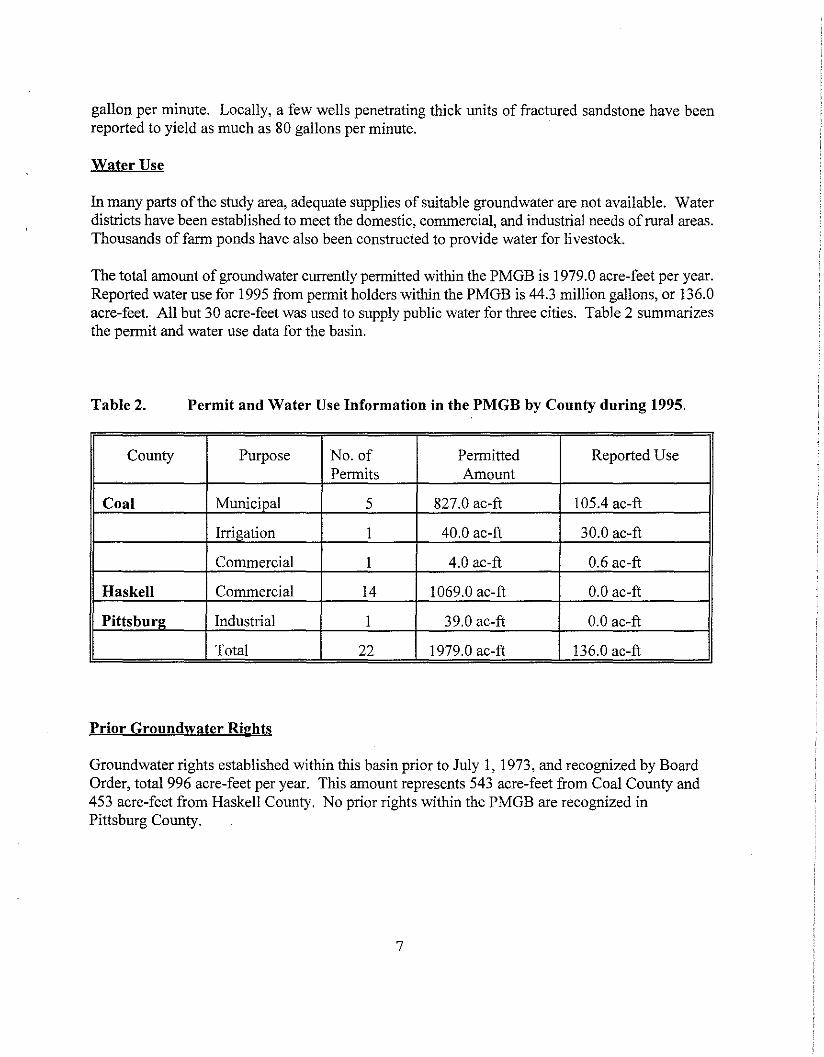
The total amount of groundwater currently permitted within the PMGB is 1979.0 acre-feet per year.Reported water use for 1995 from permit holders within the PMGB is 44.3 million gallons, or 136.0acre-feet. All but 30 acre-feet was used to supply public water for three cities. Table 2 summarizesthe permit and water use data for the basin.
Table 2. Permit and Water Use Information in the PMGB by County during 1995.
County Purpose No. of Permitted Reported UsePermits Amount
Coal Municipal 5 827.0 ac-ft 105.4 ac-ft
Irrigation 1 40.0 ac-ft 30.0 ac-ft
Commercial 1 4.0 ac-ft 0.6 ac-ft
Haskell Commercial 14 1069.0 ac-ft 0.0 ac-ft
Pittsburg Industrial I 39.0 ac-ft 0.0 ac-ft
Total 22 1979.0 ac-ft 136.0 ac-ft
Prior Groundwater Rights
Groundwater rights established within this basin prior to July I, 1973, and recognized by BoardOrder, total 996 acre-feet per year. This amount represents 543 acre-feet from Coal County and453 acre-feet from Haskell County. No prior rights within the PMGB are recognized inPittsburg County.
7

Ashland Isolated Terrace Groundwater Basin
The AITGB, located in southwestern Pittsburg County and northeastern Coal County, comprisesapproximately 24 square miles of terrace deposits that occur as unconsolidated clay, silt, sand,and gravel (Hart Jr, 1974). Terrace deposits are older alluvium which occupy positionstopographically higher than recent alluvium and mark the former position of a stream. Thedistribution of deposits within the AITGB is shown in Figure 1.
OWRB well records indicate that the average total thickness of the terrace deposit isapproximately 50 feet. The total depth of the wells ranges from 43 to 60 feet and averages 50feet. Depth to water as reported on well records ranges from 18 to 30 feet. Average saturatedthickness is estimated to be 21 feet.
Aquifer Parameters
The hydraulic characteristics of an aquifer describe its ability to store and transmit water and canbe described in terms of storage coefficient and transmissivity (T). For unconfined aquifers,storage coefficient and specific yield are nearly equivalent.
The hydraulic conductivity (K) of alluvial and terrace sediments can be estimated using arelationship between grain size and hydraulic conductivity developed by Kent and others (1973).Kent generated four ranges of hydraulic conductivity for alluvial materials based on researchinvolving field and laboratory permeability testing. Saturated lithologies presented on well logsare assigned to one of the following grain size classes. Each class has associated with it anaverage hydraulic conductivity value corresponding to the median grain size ofthat range. Thefollowing grain size classes along with their median grain size and K value are shown in Table 3.
Table 3. Hydraulic Conductivity Classes Used to Assign Permeability Values toSaturated Lithologies on Well logs.
Silt - Very Fine Very Fine Sand- Fine Sand- Medium Sand -Sand Fine Sand Medium Sand Coarse Sand
Class I Class 2 Class 3 Class 4
Median Grain 0.06 0.125 0.25 0.5Size (rnm)
K Values in 0.70 6.00 27.00 167.00Ft/dav
For each log, a weighted hydraulic conductivity can be obtained for the entire saturated sectionof the lithologic record by multiplying the average K value associated with the assigned grain
8

size class with the thickness of that interval, then summing the total for all classes divided by thetotal saturated feet of the well. Using this method, an average K value of 104 ft/day wasestimated for the AITGB. A transmissivity of2180 ft2/day was calculated using the estimatedhydraulic conductivity and a saturated thickness of 21 feet.
Another method to calculate hydraulic conductivity and transmissivity is available if wellacceptance tests (short duration pump tests) have been conducted. As a means to compare theestimated T and K values derived from the grain size analysis, data from two wells with wellacceptance tests were input into the OWRB's TOT computer program, which calculates K and T(OWRB, 1992). K and T values derived from this method are 120 ft/day and 3000 ft2/day,respectively.
Hydraulic conductivity for the AITGB was also estimated from Heath (1983). Heath developedestimated hydraulic conductivities values for sand deposits dependent primarily upon grain size.The average hydraulic conductivity for fine to coarse sediments was estimated at approximately125 ft/day. A transmissivity of2625 ft'/day was calculated using the estimated hydraulicconductivity and a saturated thickness of 21 feet.
A summary of the estimated aquifer parameters and their sources is shown in Table 4. Theaquifer parameters used in this study represent the average of the estimated values listed below.For the purpose of this study, a specific yield of 0.20 was estimated for the AITGB. This valuecompares favorably with estimates by Driscoll (1986) involving similar types of aquifermaterials.
The amount of annual recharge to the basin is estimated to be 9 percent of the average annualprecipitation or approximately 3.9 inches per year. This percentage of recharge was selected bycomparison of previous terrace deposit studies by Havens (1977).
Table 4. Estimated Aquifer Parameters for the Ashland Isolated TerraceGroundwater Basin.
Source Hydraulic Transmissivity Specific Yield Aquifer SaturatedConductivity (Fl'/day) Thickness (ft)(Ft/day)
OWRB, TOT 120 3000 .20 25
OWRB,1994' 104 2180 .20 21
Heath, 1983 125 2625 .20 21
Average 120 2600 .20 21
* -Determined from Kent and Others (1973)
9

Aquifer Storage and Yield Capabilities
The AITGB has an estimated storage of approximately 64,500 acre-feet of groundwater. Thisvalue was determined by multiplying the area of the basin (15,360 acres) by the specific yield(0.20), and the average saturated thickness (21 feet).
Yield capabilities from terrace deposits are variable, but some deposits can yield moderate tolarge quantities of water according to Johnston (1983) and Marcher (1969). Average well yieldin the AITGB as determined from the available well records is 135 gallons per minute.
Water Use
Groundwater is not heavily relied on to supply agricultural crop water. Dry-land farming isprevalent in the basin and rainfall is relied upon to provide the necessary moisture for crops.Irrigation occurs primarily during months of prolonged dryness and in areas where adequate wateris available (OWRB, 1994B). While only limited quantities of groundwater are pumped forirrigation and public water supply, individuals not served by rural water systems rely on the basinfor domestic use.
The total amount of groundwater permitted in the AITGB is currently 960.0 acre-feet per year.Reported water use for 1995 from permit holders within the AITGB was 36.9 million gallons, or113.3 acre-feet. This amount is used for public water supply for one rural water district and forirrigation. Groundwater rights and water use data for 1995 are summarized in Table 5.
Table 5. Permit and Water Use Information for the AITGB during 1995
Purpose Number of Permitted PermittedPermits Amount Use
Municipal 2 380.0 ac-ft 46.6 ac-ft
Irrigation 2 580.0 ac-ft 66.7 ac-ft
Total 4 960.0 ac-ft 113.3 ac-ft
Prior Groundwater Rights
Groundwater rights established within the AITGB prior to July 1, 1973 and recognized by BoardOrder total 165 acre-feet per year. This total amount is allocated in Pittsburg County. There are noprior rights recognized in the basin for Coal County
10

GROUNDWATER QUALITY
Pennsylvanian Minor Groundwater Basin
The chemical quality of water in the Pennsylvanian rocks is extremely variable. No relationshipbetween variations in groundwater chemistry and well depth, geographic distribution, or geologicformation is apparent according to Marcher et al (1987). Typically, groundwater is a sodiumbicarbonate type although many variations in water type occur. Concentrations of dissolved solidsrange from 300 to 2,000 milligrams per liter (mg/l) and pH ranges from 6 to 8. In most of the area,the water is hard to very hard (more that 120 mg/I). Table 6 is a summary of selected physical andchemical properties of groundwater sampled from wells within Pennsylvanian age rocks. The tableshows the minimum, mean, median and maximum concentrations for the selected parameters.
Table 6. Selected Physical Properties and Chemical Constituents in Water from 25 WellsCompleted in Pennsylvanian Rocks.
Parameter Minimum Mean Median Maximum
Well depth (feet) 21 81 78 233
Specific Conductance (umho) 460 964 800 2,690
pH (units) 6.2 --- 7.3 8.8
Hardness (Ca + Mg) 5 204 140 790(mg/I)
Calcium (mg/I) 1.8 36 24 120
Magnesium (mgll) 0.1 27 19 120
Sodium (mgll) 49 144 120 330
Chloride (mg/l) 3.4 46 30 190
Sulfate (mg!]) 4.3 151 56 870
Iron (ug/I) 20 955 110 17,000
Manganese (ug/I) 8 195 50 1,000
Dissolved solids (ROE in 294 603 520 2,010mg/I)
[umhos, micromhos per centimeter at 25° Celsius; mg/I milligrams per liter; ug/I, micrograms perliter; ROE, residue on evaporation at 1800 Celsius] Taken from Marcher, et aI, 1987.
11

In summary, the water quality of the PMGB is probably suitable for all beneficial uses except inlocalized areas. The major natural source of pollution in the area that might impact some portionsof the basin include high iron, manganese, and dissolved solids. However, with proper wellcompletion techniques (sealing out lower quality water zones), water treatment techniques, andwater quality sampling and analysis, negative health affects can be mitigated.
Ashland Isolated Terrace Groundwater Basin
Groundwater quality information regarding the AITGB is limited. However, analytical data areavailable from three public supply wells operated by Hughes County Rural Water District #2. Table7 is a summary of selected chemical properties of groundwater sampled from the District's wells inJune, 1991. Properties of primary concern include low pH and elevated levels of iron.
Documentation from an Oklahoma State Department of Health report in 1991 indicated that waterfrom the District's wells had a low pH and low alkalinity which would render the water highlycorrosive. In addition, the water was high in iron in all of the wells. Based on this information, thegroundwater was unacceptable for use as a public water supply, without treatment and only marginalwith treatment (Oklahoma State Department of Health, 1991). Mr. Tim Ward of the OklahomaDepartment of Environmental Quality (ODEQ) indicated that the low pH may be attributed todissolved carbon dioxide (C02), No analytical data were available from the ODEQ or the ruralwater district office to confirm the presence or amount of dissolved CO2,
According to Driscoll (1986), CO2 typically remains in solution under constant ambient pressureconditions. However, when the pressure near a well is reduced by pumping, CO2 is released out ofsolution as a gas. If the amount of CO, exceeds 50 mg/l, corrosive water can occur (Driscoll, 1986).To minimize the release of CO2, pressure reduction must be kept as low as possible. Use of wellscreens that provide maximum inlet area can lower entrance velocities through well screen openingsand reduce head loss (Driscoll, 1986). Domestic wells, which are typically pumped at a lower rate,have a lower potential for developing corrosive water due to the presence of dissolved CO2,
In summary, potential problems from natural contamination within the Ashland Isolated Terraceaquifer include low pH and high iron. The water is probably suitable for most beneficial uses withthe possible exception of public water supply. However, with proper well completion techniques(minimization of entrance velocity), water treatment techniques (reduction of CO2 and iron), andwater quality sampling and analysis, negative health affects can be mitigated.
12

Table 7. Summary of Selected Chemical Constituents in Groundwater from 3 PublicWater Supply Wells Completed in the Ashland Isolated Terrace Deposit.
PARAMETER VALUE UNITS PARAMETER VALUE UNITS
Chloride 24 mgll Fluoride, Total< 0.1 mgl!
Nitrite -Nitrate as N pH Lab * 5.35 std2.3 mg/I units
Specific Conductance 858 umhos/ Sulfate <20 mgllcm
Solids, Total Dissolved Alkalinity, Total119 mg/I 16 mg/l
Hardness, Total 56 mg/l Turbidity 0.33 ntu
Arsenic, Total < 15 ug/l Barium, Total 67 ug/I
Cadmium, Total <2 ug/l Chromium, Total< 10 ug/I
Copper, Total 37 ug/l Iron, Total 92 ug/I
Lead, Total <5 ug/l Manganese, TotalII ug/I
Mercury, Total < 0.5 ug/l Selenium, Total<5 ug/l
Silver, Total <3 ug/l Sodium, Total 21 ug/I
Zinc, Total 25 ug/l
* -Exceeds PWS Standardsug/l - micrograms per liter< - Less than Detection Limitmgll - milligrams per literumhos - micromhos per centimeter
Source - Hughes County Rural Water District #2 - All Results from June 19, 1991 Sampling
13

SUMMARY
Pennsylvanian Minor Groundwater Basin
The following data on Pennsylvanian Minor Groundwater Basin were derived in order to calculateand determine the Maximum Annual Yield and Equal Proportionate Share of the basin:
I) The total land area overlying the basin is 1,571,840 acres;2) The amount ofwater in storage in the basin on July I, 1994 was determined to be 23,105,000
acre-feet; .3) The estimated rate ofrecharge is 2.5 percent ofthe average annual precipitation (42 inches)
and totals approximately 2,881,707 acre-feet, and the total discharge of the basin is 19,920acre-feet over the life of the basin (20 years);
4) The transmissivity of the basin is estimated to be 131.0 ft'/day;5) The possibility of pollution ofthe basin from natural sources such as high iron, manganese,
and dissolved solids can be minimized by proper well construction, treatment, and waterquality testing and analysis.
Ashland Isolated Terrace Groundwater Basin
The following data on the Ashland Isolated Terrace Groundwater Basin were derived in order tocalculate and determine the Maximum Annual Yield and Equal Proportionate Share of the basin:
I) The total land area overlying the basin is 15,360 acres;2) The amount of water in storage in the basin on July I, 1994 was approximately 64,500 acre
feet;3) The estimated rate of recharge is 9 percent of the average annual precipitation (42 inches)
and totals approximately 99,800 acre-feet, and the total discharge of the basin is 3300 acrefeet over the life of the basin (20 years);
4) The transmissivity of the basin is estimate at 2600 ft'/day;5) The possibility ofpollution ofthe basin from natural sources such as low pH (dissolved CO~
and iron can be minimized by proper well construction, treatment, and water quality testingand analysis;
The maximum annual yield and equal proportionate share results are provided in an accompanyingreport entitled Maximum Annual Yield Determination for the Ashland Isolated Terrace andPennsylvanian Minor Bedrock Basin in Coal, Pittsburg, and Haskell Counties.
14

REFERENCES
Brinlee, R.C., 1975, Soil Survey of Haskell County, Oklahoma: U.S. Department of Agricultural,Soil Conservation Service, pp 1-4.
Driscoll, Fletcher, 1986, Groundwater and Wells, Second Edition, p 737-738.
Hart, Donald L., Jr., 1974, Reconnaissance of the Water Resources of the Ardmore and ShennanQuadrangles, Southern Oklahoma: Oklahoma Geological Survey Hydrologic Atlas 3,1:250,000, 4 Sheets.
Havens, J. S., 1977, Reconnaissance of the Water Resources ofthe Lawton Quadrangle, Southwestern Oklahoma: Oklahoma Geological Survey HydrologicAtlas 6, 1:250000, 4 sheets.
Heath, R.C., 1983. Basic Ground-Water Hydrology. U.S. Geological Survey Water Supply Paper,2220,84 pp.
Johnston, Kenneth S., 1983, Maps Showing Principal Ground-water Resources and Recharge areasin Oklahoma: Sheet 1 - Unconsolidated Alluvium and Terrace Deposits, OklahomaGeological Survey.
Kent, D. C., J. W. Naney and B. B. Barnes, 1973, An Approach to Hydrogeologic Investigations ofRiver Alluvium: Groundwater, V. II, no. 4, pp. 30-42.
Marcher, Melvin V., 1969, Reconnaissance ofthe Water Resources of the Fort Smith Quadrangle,East-Central Oklahoma: Oklahoma Geological Survey Hydrologic Atlas 4, 1:250,000, 4Sheets.
Marcher, Melvin V. and Bergman, DeRoy L., 1983, Reconnaissance of the Water Resources of theMcAlester and Texarkana Quadrangles, Southeastern Oklahoma: Oklahoma GeologicalSurvey Hydrologic Atlas 9, 1:250,000,4 Sheets.
Marcher, Melvin V. et aI, 1987, Hydrology of Area 41, Western Region, Interior Coal Province,Oklahoma and Arkansas: U.S. Geological Survey, Water-Resources Investigations, OpenFile Report 84-129.
Moebius, G.E., Shingleton, L.C., and Bogard, VA, 1974, Soil Survey of Coal County, Oklahoma:U.S. Department of Agricultural, Soil Conservation Service, pp 2-3, 57.
Oklahoma Corporation Commission, 1982, Unpublished maps indicating base of fresh groundwaterin Coal, Pittsburg, and Haskell Counties.
15

Oklahoma Department of Environmental Quality, 1995, Personal Communication from Mr. TimWard, Engineer, Oklahoma Department of Environmental Quality, January 18, 1995.
Oklahoma State Department of Health, 1991, Correspondence from Oklahoma State HealthDepartment to Landes Engineering, March, 14, 1991.
Oklahoma Water Resources Board, 1990. Oklahoma Water Atlas. University ofNorman PrintingServices, Norman, OK. p 16.
Oklahoma Water Resources Board, 1992, T-O-T, A Program for Delineation of a WellheadProtection Area by Semi-Analytical Methods for a Single Pumping Well.
Oklahoma Water Resources Board, 1993, Unpublished Water Use Data for Coal, Pittsburg, andHaskell Counties.
Oklahoma Water Resources Board, 1994A, Unpublished Multi-Purpose Completion ReportRecords: Coal, Pittsburg, and Haskell Counties.
Oklahoma Water Resources Board, 1994B, Field Observation in Pittsburg County, December 1994.
Shingleton, Lyle C., 1971, Soil Survey of Pittsburg County, Oklahoma: U.S. Department ofAgricultural, Soil Conservation Service, pp 1-7.
Sutherland, Patrick K. and Manger, Walter 1., 1984, The Atokan Series (Pennsylvanian) and ItsBoundaries - A Symposium, Oklahoma Geological Survey Bulletin 136 ISSN 0078-4389 P9.
16

GLOSSARY
AlluviumA general tenn for clay, silt, sand, and gravel, or similar unconsolidated material depositedduring comparatively recent geologic time by stream or other body of running water as asorted or partially sorted sediment in the bed of the stream or on its flood plain or delta, oras a cone or fan at the base of a mountain slope.
AquiferA fonnation, group of fonnations, or a part of a fonnation that contains sufficient saturatedpenneable material to yield significant quantities of water to wells and springs.
Equal Proportionate ShareThat portion of the maximum annual yield of water from a groundwater basin which shallbe allocated to each acre of land overlying such basin. The percentage of the maximumannual yield is equal to the percentage of the land overlying the fresh groundwater basinwhich is owned or leased by an applicant for a regular pennit.
Fresh WaterWater which has less than five thousand (5,000) parts per million total dissolved solids. Allother water is salt water.
GroundwaterFresh water under the surface of the earth regardless of the geologic structure in which it isstanding or moving outside the cut beds or banks of any definite stream.
Groundwater BasinA distinct underground body of water overlain by contiguous land having substantially thesame geological and hydrological characteristics and yield capabilities. The areal boundariesof a basin can be detennined by political boundaries, geological, hydrological, or otherreasonable physical boundaries.
Hydraulic ConductivityThe volume of water that will move through a medium in a unit of time under a unithydraulic gradient through a unit area measured perpendicular to the direction of flow.
Life of a Groundwater BasinThat period of time during which pumping of the maximum annual yield for a minimumtwenty year life of such basin will result in a final basin storage which approaches zero.Fifteen feet of saturated thickness is maintained in bedrock aquifers to provide for domesticuse.
17

Major Groundwater BasinA distinct underground body of water overlain by contiguous land and having substantiallythe same geological and hydrological characteristics and from which groundwater wellsyield at least fifty gallons per minute on the average basinwide if from a bedrock aquifer andat least one hundred fifty gallons per minute on the average basinwide if from an alluviumand terrace aquifer, or as otherwise designated by the Oklahoma Water Resources Board(Board).
Maximum Annual YieldA determination by the Board of the total amount of fresh groundwater that can be producedfrom each basin allowing a minimum twenty year life of such basin.
Minor Groundwater BasinA distinct underground body of water overlain by contiguous land and having substantiallythe same geological and hydrological characteristics and from which groundwater wellsyield less than fifty gallons per minute on the average basinwide iffrom a bedrock aquiferand less than one hundred fifty gallons per minute on the average basinwide if from analluvium and terrace aquifer, or as otherwise designated by the Oklahoma Water ResourcesBoard (Board).
Natural RechargeAll flow ofwater into a groundwater basin by natural processes including percolation fromirrigation.
PermeabilityThe property of a porous medium to transmit fluids under a hydraulic gradient.
PorosityThe ratio, usually expressed as a percentage, of the total volume of voids of a given porousmedium to the total volume of the porous medium.
Prior Groundwater RightThe right to use groundwater established by compliance with the laws in effect prior to July1,1973, the effective date of the Oklahoma Groundwater Act.
Specific YieldThe ratio of the volume of water which the porous medium after being saturated, will yieldby gravity to the volume of the porous medium.
Storage CoefficientThe volume of water an aquifer releases from or takes into storage per unit surface area ofthe aquifer per unit change in head (virtually equal to the specific yield in an unconfinedaquifer).
18

Terrace DepositsDeposits of older alluvium which occupy positions topographically higher than recentalluvium and mark the former position of a stream.
Total Discharge from the BasinShall include but may not be limited to the amount of fresh groundwater withdrawn andplaced to beneficial use prior to July I, 1973, which amount shall be determined from theapplicable final orders of the Board determining prior groundwater rights.
TransmissivityThe rate at which water of the prevailing kinematic viscosity is transmitted through a unitwidth of the aquifer under a unit hydraulic gradient.
19