Embed Size (px)
Citation preview

17
HYDROCHEMICAL ASSESSMENT OF UNCONFINED AQUIFER SYSTEM IN BAYAT MELANGE COMPLEX, KLATEN, INDONESIA
*Putranto, T.T.1, Hidajat, W.K.1 and Wijaya, H.1
1Geological Engineering Department, Faculty of Engineering, Diponegoro University, Indonesia
*Corresponding Author, Received: 27 April 2017, Revised: 09 May 2017, Accepted: 20 June 2017
ABSTRACT: The geological setting of Bayat that has a complexity in structural geology as well as a variety of lithology because this region is interesting to be investigated from the hydrogeological point of view. Hydrogeological assessments were conducted based on the hydrogeological and geological mapping, as well as hydrochemical analysis. Groundwater level measurements were carried out at 51 measurement points. There were 25 groundwater samples to be analyzed the ion content by using Ion Chromatography and ICP-OES. There are seven (7) lithology units i.e. Schist-phyllite-marble, Nummulities limestone, Diorite intrusion, Pebbly sandstone, Layered limestone, Colluvial and Alluvial deposit based on the surface geological mapping. The geological structure investigation in Temas Hill conduct the trends of structural orientation that are northeast to southwest. They become the point of infiltration and circulation pathways in the crystalline bedrock. Hydrochemical analysis obtain five (5) groundwater facies. They are Ca-Mg-HCO3, a mix of Ca-Na-HCO3-Cl, Na-HCO3, Ca-SO4 and Na-Cl. The concentration abundances of cation are Na+>Ca2+>Mg2+>K+ while HCO3
->Cl->SO42->NO3
- represent anion content. A Gibbs diagram shows that the dissolved ions are dominated by rock weathering process. Na+ ion is derived from the weathering of feldspar-rich mineral, Ca2+ and Mg2+ indicate through limestone dissolving. The high Cl- ion content in some samples is predicted from the mixing of upwelling fossil water through Trembono strike-slip fault. Keywords: Bayat, Groundwater level, Hydrochemical, Groundwater facies, Upwelling 1. INTRODUCTION Bayat District is geographically located at coordinates of Longitude 110˚38'25.8"E to 110˚41'9.24"E and Latitude of -7˚47'55.32"S to -7˚45'48.6"S in Klaten Regency, Central Java Province/Indonesia (Fig. 1). Bayat has a complete type of rocks exposed at the surface. In geoscience, originally rocks divided into three major groups, i.e. igneous (crystallised from molten magmas), sedimentary (lithified from eroded surface materials), and metamorphic (compacted from other existing rocks). All of those rocks are widespread in a short distance in Bayat, exposure past processes of rock deformation (fracturing, faulting, and folding) and present-day processes of rock uplift, weathering and erosion [1]. The complexity of geologic setting in Bayat is interested to be investigated from the hydrogeological point of view.
Hydrochemical assessments are focused on an unconfined aquifer system in this area due to its dynamic condition and also affected by the fluctuation of the seasons. A tropical region such as Bayat (Indonesia) has two seasons, the rainy and dry seasons. A short hydrologic cycle generates a groundwater flow mechanism, as well as the physical and chemical property of groundwater in this aquifer system, is easily changed. It can be affected by the infiltration of surface water,
groundwater interaction with rocks, as well as human activities such as excessive groundwater exploitation and the use of chemicals contain for agriculture and industry.
The local residents withdraw groundwater in unconfined aquifer via dug wells. This aquifer is one of the main water resources that used to meet the needs of daily drinking water. A hydrogeological study in this aquifer is necessary to determine the condition of groundwater level, groundwater flow patterns, as well as hydrochemical. Thus, the utilisation of groundwater resources in this area can be done optimally while maintaining the stability of groundwater itself.
2. GEOLOGIC SETTING OF BAYAT
The study area is a melange zone that geologically located in the Southern Mountains Basin. [2] divides the stratigraphic settings in the Southern Mountains into three periods that sorted based on the chronology of geological time. A time before the intense volcanism activity is called the pre-volcanism, a period of intensively volcanism activity is called volcanism period and a period after volcanism activity is called post-volcanism or carbonate period. Based on the correlation to the regional stratigraphy of Southern Mountain Basin [3], the study area is divided into seven lithological units (Fig. 1). Sorted by the geological age from old
International Journal of GEOMATE, Nov., 2017, Vol.13, Issue 39, pp.17-24 Geotec., Const. Mat. & Env., ISSN:2186-2990, Japan, DOI: https://doi.org/10.21660/2017.39.17336

International Journal of GEOMATE, Nov., 2017, Vol.13, Issue 39, pp.17-24
18
Fig 1. Location of study area showing geological map [1], groundwater sampling locations, and groundwater
level measurement points to young are Schist-phyllite-marble, Nummulites limestone, Diorite intrusion, Pebbly sandstone, Layered limestones, Colluvium and Alluvial deposit.
The basement complex mostly composes of metamorphic rocks, such as Schist-phyllite-marble. Phyllites are the most widespread among other metamorphic rocks, generally in weathered condition with some quartz veins and calcite veins aligned with their [1]. The basement rocks age is around Cretaceous (older than 66 million years ago/mya) by a finding of Orbitolina [4]. Moreover, to predict more accurate of the basement rock age, an application of K-Ar absolute dating of two samples of quartz-mica schist was applied [5]. It resulted in around 98 mya, which belongs to Late Cretaceous epoch. The metamorphic rocks form during a regional metamorphism that involved along with an ancient subducting lithospheric plate and the plates collision afterwards [6]. Subsequent erosion took place for millions of years had uplifted and peneplain those metamorphic rocks, and placed them as the basement rocks for the next oncoming sedimentary sequences [1].
Unconformably overlying the metamorphic basement rocks are Wungkal-Gamping Formation. It has two distinct members, Wungkal and Gamping Members occupies the lower and upper parts, respectively. Wungkal Member deposited during Early to Middle Eocene (55-40 mya) consists of
quartz conglomerates, polymict breccias, quartz sandstones, calcareous sandstones, calcareous siltstones, and some intercalation of Nummulitic limestones. Gamping and Wungkal Members are interfingering each other deposited during Middle to Late Eocene (approximately 48-34 mya) compose of mainly Nummulitic limestones, micritic sandstones, and quartz-arenite sandstones. The Wungkal-Gamping Formation gradually become Kebo-Butak Formation deposite around Late Oligocene to Early Miocene (28-20 mya), which at the lower part composed of sandstones, gravelly sandstones, siltstones, claystone, tuff, and shales. The middle part consists of pebbly sandstones, whilst the upper part is of polymict breccias, sandstones, pebbly sandstones, claystone, siltstones, and shales. Numerous igneous intrusions are producing diorite, diabase, andesite, and basalt intrusion in the period of Late Oligocene [3]. After, volcanic activities had gradually deceased; it forms shallow marine carbonate sequences to be developed at the end of Early Miocene compose of well-bedded limestones (Wonosari Formation). The deposition of Wonosari Formation occurs approximately since 16 to 5 mya. Colluvial and alluvial deposits is the recent product due to erosion and weathering activities. The structural geology is a thrust fault which cut the block of Schist-phyllite-marble and Diorite intrusion. While the fractures can be found in

International Journal of GEOMATE, Nov., 2017, Vol.13, Issue 39, pp.17-24
19
several places, one of them is in Temas Hill. The trends of structural orientation are northeast to southwest. Temas Hill is composed of layered limestone lithology. The study area is composed of crystalline basement rocks that are impermeable rock type. The feature of faults and fractures in the rocks can become a point of infiltration and groundwater flow circulation path in this aquifer. 3. METHODS
3.1 Data and analysis
The field campaign was conducted during the period of a dry season (August 2015). The measurement of groundwater level at 51 (fifty-one) stations. Twenty-five (25) selected groundwater samples (Fig.1) were taken by using bottle polyethylene for analyzing hydrochemistry content in the laboratory of Rheinisch-Westfälische Technische Hochschule (RWTH) Aachen University, Germany. Hydrochemistry contents consist of cations i.e. Na+, K+, Ca2+, Mg2+, and anions such as Cl-, SO4
2-, HCO3-, NO3
-. Ion Chromatography [7] performed anions content. Cations were analyzed by Inductively Coupled Plasma-Optical Emission Spectrophotometer (ICP-OES) [8]. Data were visualized into some graphics by using Aquachem 2012.1. 3.2 Groundwater Quality Assessment The evaluation of groundwater quality was analysed by Ion Balance Error (IBE) based on cation and anion content for determining groundwater facies. Raw data were available in [15]. Indeed, the present of cation and anion content of groundwater from several lithologies performed a rock-groundwater interaction. Total Dissolved Solid/TDS represents as a sum of cations and anions value. Electrical Conductivity/EC and pH were measured by WtW Cond 3110 and WtW pH 3210, respectively. Saturation Indice and pH were analyzed to identify some minerals from several lithologies under saturated conditions. 3.3 Analysis of Spatial Data The spatial data such as groundwater level, pH, and EC were analyzed by using Surfer 9 and ArcGIS 10 to determine the distribution and spatial correlation of each data. Two types of interpolation methods applied in this study. Data that has no significant value between adjacent data such as groundwater level was mapped using Minimum Curvature interpolation. This method uses the slope calculation that changes based on the distance to
estimate the shape of the surface. For data that has a significant value between adjacent data such as pH, EC was mapped using the Inverse Distance to Power (IDP). IDP method assumes that each input point has local influence that reduced toward the distance. 4. RESULT AND DISCUSSION
4.1 Aquifer and Groundwater Flow
The aquifer that becomes the focus attention in this study is an unconfined aquifer. It is easily affected by seasonal fluctuations because the hydrology cycle is relatively short. During the rainy season, the groundwater level will be shallower than in a dry season.
Unconfined aquifers in the study area can be classified into two types of aquifer based on its lithology characteristics. The first type is primary unconfined aquifer where the lithology of this aquifer has a primary porosity and permeability. Thus, groundwater can circulate through the pores. The lithologies that grouped into this aquifer are pebbly sandstone, colluvial and alluvial deposit. The second is an aquifer that composed of a little amount of water. This aquifer consists of fractured crystalline rocks. Water can circulate in these rocks through the secondary porosity and permeability. Lithology that grouped into this aquifer consists of Schist-phyllite-marble, Diorite intrusion, Layered limestone. Groundwater flows from Eastern Jiwo Hills area (isolated hills) towards the plain of alluvial deposit (Fig, 2). The eastern Jiwo Hills area is a recharge zone where meteoric water could infiltrate through the fractures and fill the aquifers up. While the alluvial plains area that has a lower elevation acts as a discharge zone. The rivers in the study area are effluent streams and found in dry conditions caused by the decline of groundwater levels in this area. 4.2 Hydrochemical analysis Groundwater samples are grouped into six groups based on the type of lithology. In alluvial deposit, there are five samples as well as layered limestone. There are two samples of gravelly sandstone while diorite intrusion has four samples. Six samples represent colluvial deposits, and around three samples represent in schist-phyllite-marble. Chemical analysis of data correction is analysed by calculating IBE based on the main content of cations and anions. From the calculations obtained the IBE values ranged from 0.1 to 7.3%.

International Journal of GEOMATE, Nov., 2017, Vol.13, Issue 39, pp.17-24
20
Fig. 2 Groundwater level and its flow direction
The pH values are around 6.81-7.86 with an average of 7.22. It indicates groundwater is neutral. An EC value has a range from 507 to 5,500 µS/cm with an average of 1,341 µS/cm that indicates the water comes from groundwater and seawater [9]. Total Dissolved Solid (TDS) has a range from 240-4,473 mg/L with an average of 2,030 mg/L that indicates the water is fresh to salt [10]. Geographically, the study area is quite far from the coastal zone and there are no hydrothermal, industrial or mining activity, so the possibility of salt-water origin is not affected by those factors.
The high number of EC and TDS are predicted from mixing of upwelling fossil water through Trembono strike-slip. The Na+ ion contents are in a range from 6.44 to 882 mg/L. Cl- ion is around 8.55-669 mg/L, and SO4
2- varies between 5-1,769 mg/L (Table 1). The high content of Na+, Cl-, and SO4
2- represent the characteristic of seawater or fossil water origin. The abundance of cations contains Na+>Ca2+>Mg2+>K+ while anions is HCO3
->SO42->Cl->NO3.
Table 1. Hydrochemistry data
Sample Code
pH EC (µS/cm)
K+ (mg/L)
Ca2+ (mg/L)
Mg2+ (mg/L)
Na+ (mg/L)
SO42-
(mg/L) Cl-
(mg/L) HCO3
- (mg/L)
NO3-
(mg/L) TDS
(mg/L) Lithology
1 6.94 697 3.53 102 7.56 10.7 148 18.1 200 2.5 492 Schist-Phyllite-Marble 2 6.99 622 1.22 103 12.0 15.4 5 13.6 371 2.5 524 Colluvial Deposit 3 7.58 884 0.50 80.1 26.5 36.6 29.8 28 419 2.5 623 Colluvial Deposit 4 7.05 1,046 1.72 84.2 54.5 28.9 14.7 55.2 530 21.5 791 Colluvial Deposit 5 7.24 989 3.66 138 21.6 32.8 41.6 73.1 438 5.75 754 Schist-Phyllite-Marble 6 7.59 882 1.18 93.9 33.1 61.5 20.8 31.7 513 2.5 757 Diorite intrusion 7 7.19 2,040 4.31 246 24.6 128 10.6 431 360 2.5 1,207 Diorite intrusion 8 7.40 935 0.50 76.0 59.5 60.3 5 31 548 14.1 794 Diorite intrusion 9 7.13 811 1.10 96,7 35.8 26.8 14.6 13.6 472 20.5 681 Layered Limestone
10 7.04 709 0.50 112 18.4 16 10.8 12.9 407 2.5 580 Layered Limestone 11 7.46 687 0.50 92.7 11.2 17.1 5 15.3 394 2.5 539 Layered Limestone 12 7.29 779 0.50 75.8 43.9 31.8 5 15 447 25.6 645 Layered Limestone 13 6.81 783 1.41 92.9 27.9 40.9 25.5 50.4 344 6.54 590 Colluvial Deposit 14 7.29 1,264 1.68 45.0 29.4 192 48.1 40 790 2.5 1,149 Colluvial Deposit 15 7.86 1,024 6.85 106 16.3 103 113 54.5 458 6.93 865 Colluvial Deposit 16 7.09 963 5.35 155 3.61 26.9 41.7 54 395 27.9 709 Schist-Phyllite-Marble 17 7.23 883 3.08 108 15.2 80.1 53.1 43.1 464 2.5 769 Diorite intrusion 18 7.19 2,740 1.58 180 88.6 356 592 223 694 2.5 2,137 Alluvial Deposit 19 7.29 1,951 1.86 83.7 18.2 384 506 56.4 696 2.5 1,748 Alluvial Deposit 20 6.88 699 0.5 137 3.71 6.44 5 8.55 406 2.5 570 Alluvial Deposit 21 7.18 1,434 4.32 76.5 23.7 200 204 24.4 688 2.5 1,223 Alluvial Deposit 22 7.64 1,282 1.42 48 23.8 238 45.7 37 730 2.5 1,127 Layered Limestone 23 6.83 507 1.56 47.8 14.3 43.3 19.4 14.3 257 2.5 401 Pebbly Sandstone 24 7.21 3,410 2.61 169 47.5 629 1,190 99.7 689 2.5 2,829 Pebbly Sandstone 25 7.20 5,500 5.10 356 144 882 1,769 669 646 2.5 4,474 Alluvial Deposit

International Journal of GEOMATE, Nov., 2017, Vol.13, Issue 39, pp.17-24
21
4.2 Hydrochemical Facies
Several factors control the chemical composition of groundwater, such as the physical condition of the aquifer, the mineral composition of rocks and climate conditions. Based on the plot of Piper diagram [11] groundwater samples conducted various groundwater facies in the study area (Fig. 3). Ca-Mg-HCO3 water type represents samples of diorite intrusion, layered limestone and schist-phyllite-marble. Two samples of layered limestone show Ca-SO4 water type. Pebbly sandstone, alluvial and colluvial deposits indicate mixing of Ca-Na-HCO3-Cl, Na-HCO3, and Ca-SO4 type. Based on the groundwater facies group, Ca-Mg-HCO3 type is the most dominant, up to 60%, of the groundwater samples. It then followed by facies of mixing Ca-Na-HCO3-Cl with amount around 16%. Na-HCO3 and Ca-SO4 almost 8%, as well as the presence of Na-Cl up to 8%. Hydrochemical facies generally show the local distribution, so it has a close spatial correlation. 4.4 Rock-Groundwater Interaction
4.4.1 Gibbs diagram
The results on Gibbs diagram [14] (Fig. 4 and Fig. 5) shows that almost all groundwater samples are plotted in the rock dominance area except the samples of alluvial deposit and. It indicates that the concentration of ions in groundwater both cations and anions derived from the weathering and dissolution of minerals in the rocks. Weathering and dissolution are possible to come from dissolving layered limestone, weathering of pebbly sandstones and also weathering of silicate minerals from the crystalline basement such as diorite intrusion and schist-phyllite-marble. Some samples of alluvial deposit group are placed in the the evaporation area. It indicates the evaporation process is very high in the alluvial aquifer. This condition is supported by the of climatic conditions in the study area that has a tropical climate. Moreover, the measurements conduct in the period of dry season. The process of evaporation will increase the concentration of ions in groundwater because some of the water evaporate and leaves the dissolved solids. It is also supported by the relatively high value of TDS. The high value of TDS is also caused by the enrichment sodium and chloride ions that is generally derived from seawater or fossil water. On Gibbs diagram, no sample plotted on rainfall zone, because the field campaign is conducted during a dry season. However, the process of evaporation and precipitation are the secondary factors that affect the properties of hydrochemical in groundwater.
4.4.2 Scatter Plot Cl- vs Na+
From the results of scatter plot between Cl- ions vs Na+ ions with the value of equiline 1:1 (Fig. 6), groundwater samples are plotted above the equiline. It shows the population of the Na+ ion is more dominant than the Cl- ion. Na+ ion likely comes from the weathering of Na-Silicate rich mineral such as sodium plagioclase from crystalline basement. In addition, Na+ ions can also be derived from seawater or fossil water that contain salt mineral (NaCl). Some samples of the alluvial deposit and pebbly sandstones show the Cl- value is higher than the Na+ value, where the samples are plotted below the equiline. These conditions indicate the existence of Cl- ion enrichment in some groundwater aquifers that indicate a fossil water mixing. [12] reported that fossil water likely comes from lenticular aquifers. Alluvial deposits in this area are volcanic materials carried out by fluvial activity during the Holocene age. Lenticular deposit may still occur in the floodplains because the deposition takes place in the terrestrial environment. It will not carry out the salt water. Fossil water comes from the Tertiary sedimentary rocks deposited in the marine environments. The existence of Trembono strike-slip fault can become an upwelling path for fossil water and it then mixing with shallow groundwater. Fossil water is located at a certain depth and the possibility to interact with shallow groundwater is slight. The presence of uplift basement (Schist-Marble-Phyllite) that are exposed to the surface indicate the tectonic activity has raised the rock formations up that bring fossil water become shallow. 4.4.3 Scatter Plot (HCO3
- + SO42-) vs (Ca2+ + Mg2+)
The Ca2+ and Mg2+ are the cations that are affected by the dissolution of carbonates minerals. A scatter plot between (HCO3
- + SO42-) vs (Ca2+ +
Mg2+) show the dominant weathering process occurred (Fig. 7). Chemical data of groundwater samples taken in alluvial deposit, gravelly sandstone, diorite intrusion, schist-phyllite-marble and colluvial deposit are plotted below the equiline 1:1. It indicates the weathering processes are dominated by the weathering of silicate minerals. Dissolved ions derived from the silicate mineral-rich rocks represent the possibility of weathering-derived from metamorphic rocks types and diorite intrusions. Pebbly sandstones, in this area come from the volcanic material destruction, contain high silica. It indicates an abundant feldspar mineral in the rocks (KAlSi3O8-NaAlSi3O8-CaAl2Si2O8).

International Journal of GEOMATE, Nov., 2017, Vol.13, Issue 39, pp.17-24
22
Fig. 3 Groundwater samples plot on Piper diagram
Fig. 4 Gibbs diagram (Na+, K+, and TDS) Fig. 5 Gibbs diagram (Cl-, HCO3-, and TDS)
Fig. 6 Scatter plot Cl- vs Na+ Fig. 7 Scatter plot (HCO3
- + SO42-) vs (Ca2+ + Mg2+)
In addition, feldspar minerals weathering also produce a lot of sodium (Na+) and potassium (K+) ions in groundwater. Moreover, weathering of carbonate also can be found mainly in layered limestone and some samples of diorite intrusion, schist-phyllite-marble and colluvial deposit. It represents that lithology have pH with slightly more acid than alluvial deposits. The more acidic pH will increase the aggressiveness of groundwater in dissolving minerals, especially calcium and carbonate. Rainwater will be naturally slightly acid
because it reacts with atmospheric carbon dioxide into carbonic acid Eq. (1). H2O + CO2 → H2CO3 (1) The meteoric water can infiltrate through the cracks and occurs chemical reaction between the carbonic acid with calcite Eq. (2) and dolomite Eq. (3) via some intensive fractures in layered limestone.
0102030405060
0 20 40 60
Ca2++Mg2
+(m
eq/L)
HCO3- +SO4
2- (meq/L)
SilicateWeathering
CarbonateWeathering
0
10
20
30
40
0 10 20 30 40
Na+(m
eq/L)
Cl- (meq/L)
110100
100010000
0 0.5 1
TDS(m
g/L)
(Na++K+ /Na+)+K+ +Ca2+(meq/L)
Rainfall
RockDominance
Evaporation
Mineralization
Freshening
110
1001000
10000
0.0 0.2 0.4 0.6 0.8
TDS(m
g/L)
Cl- /(Cl- +HCO3-)(meq/L)
Evaporation
RockDominance
Mineralization
Freshening
Rainfall
International Journal of GEOMATE, Nov., 2017, Vol.13, Issue 39, pp.17-24
23
CaCO3 + H2CO3 → Ca2+ + 2HCO3- (2)
CaMg(CO3)2 + H2CO3 ⇋ Ca2+ + Mg2+ + 4HCO3- (3)
Based on the reaction above, the result of the dissolution of calcite or dolomite will generate Ca2+, Mg2+, and HCO3
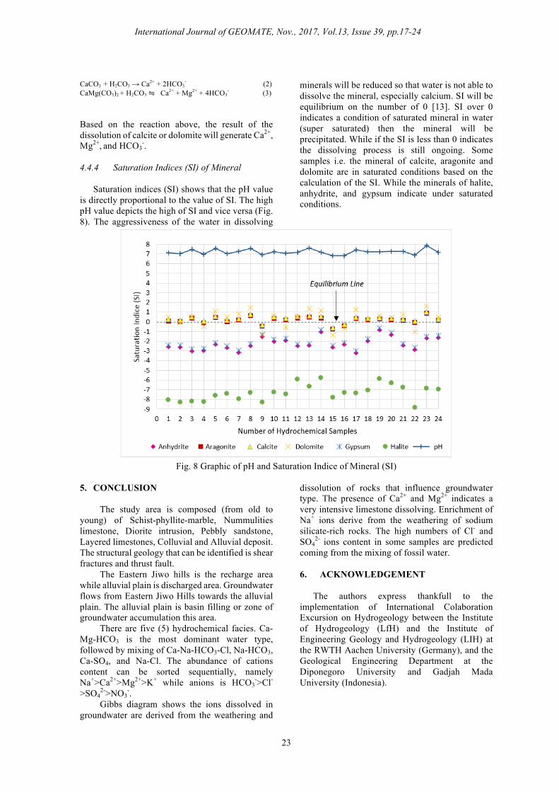
-. 4.4.4 Saturation Indices (SI) of Mineral
Saturation indices (SI) shows that the pH value is directly proportional to the value of SI. The high pH value depicts the high of SI and vice versa (Fig. 8). The aggressiveness of the water in dissolving
minerals will be reduced so that water is not able to dissolve the mineral, especially calcium. SI will be equilibrium on the number of 0 [13]. SI over 0 indicates a condition of saturated mineral in water (super saturated) then the mineral will be precipitated. While if the SI is less than 0 indicates the dissolving process is still ongoing. Some samples i.e. the mineral of calcite, aragonite and dolomite are in saturated conditions based on the calculation of the SI. While the minerals of halite, anhydrite, and gypsum indicate under saturated conditions.
Fig. 8 Graphic of pH and Saturation Indice of Mineral (SI)
5. CONCLUSION
The study area is composed (from old to young) of Schist-phyllite-marble, Nummulities limestone, Diorite intrusion, Pebbly sandstone, Layered limestones, Colluvial and Alluvial deposit. The structural geology that can be identified is shear fractures and thrust fault. The Eastern Jiwo hills is the recharge area while alluvial plain is discharged area. Groundwater flows from Eastern Jiwo Hills towards the alluvial plain. The alluvial plain is basin filling or zone of groundwater accumulation this area. There are five (5) hydrochemical facies. Ca-Mg-HCO3 is the most dominant water type, followed by mixing of Ca-Na-HCO3-Cl, Na-HCO3, Ca-SO4, and Na-Cl. The abundance of cations content can be sorted sequentially, namely Na+>Ca2+>Mg2+>K+ while anions is HCO3
->Cl-
>SO42->NO3
-. Gibbs diagram shows the ions dissolved in groundwater are derived from the weathering and
dissolution of rocks that influence groundwater type. The presence of Ca2+ and Mg2+ indicates a very intensive limestone dissolving. Enrichment of Na+ ions derive from the weathering of sodium silicate-rich rocks. The high numbers of Cl- and SO4
2- ions content in some samples are predicted coming from the mixing of fossil water. 6. ACKNOWLEDGEMENT
The authors express thankfull to the implementation of International Colaboration Excursion on Hydrogeology between the Institute of Hydrogeology (LfH) and the Institute of Engineering Geology and Hydrogeology (LIH) at the RWTH Aachen University (Germany), and the Geological Engineering Department at the Diponegoro University and Gadjah Mada University (Indonesia).

International Journal of GEOMATE, Nov., 2017, Vol.13, Issue 39, pp.17-24
24
7. REFERENCES
[1] Husein S and Novian I, “Guide Book of Geological Excursion-Bayat”, Central Java, Yogyakarta, Indonesia, 2014, pp. 1-12.
[2] Surono, “Litostratigrafi Pegunungan Selatan Bagian Timur Daerah Istimewa Yogyakarta dan Jawa Tengah (Lithostratigraphy of Eastern South Mountain Yogyakarta Special Region and Central Java)“, JGSG Vo.19 (3), 2009, pp. 209-221.
[3] Surono, Hartono U, and Permanadewi S, “Posisi Stratigrafi dan Petrogenesa Intrusi Pendul, Perbukitan Jiwo, Bayat, Kabupaten Klaten, Jawa Tengah (Stratigraphy and Petrography of Pendul Intrusion, Jiwo Hills, Bayat, Klaten Regency, Central Java)”, Jurnal Sumber Daya Geologi Vol XI (5), 2006, 302-311.
[4] Bothé AChD, “Jiwo Hills and Southern Range Excursion Guide”, 4th Pacific Science Congress, Java, Bandung, 1929, pp1-14.
[5] Prasetyadi C, “Evolusi Tektonik Paleogen Jawa Bagian Timur (Tectonic Evolution in Easter Java)”, Disertation, Engineering Geology Department, Institute of Technology Bandung, 2007, Unpublished.
[6] Setiawan, NI, Husein S, and Alfyan MF, “Speculative models of exhumation on high-pressure low-temperature metamorphic rocks from central part of Indonesia: an implementation of concepts and processes”, Proceeding of the 7th National Conference on Geoscience, Yogyakarta, 2014, pp. 504-523.
[7] DIN EN ISO 10304-2, “Bestimmung der gelösten Anionen mittels Ionenchromatographie Teil 2: Bestimmung von Bromid, Chlorid, Nitrat, Nitrit, ortho-Phosphat und Sulfat in Abwasser (Water quality - Determination of dissolved anions by liquid chromatography of ions - Part 2: Determination of bromide, chloride, nitrate, nitrite, orthophosphate and sulfate in waste water)”, Deutsches Institut für Normung. Berlin: Beuth Verlag, 1996, pp. 1-15.
[8] DIN EN ISO 11885, “Wasserbescha_enheit -
Bestimmung von ausgewählten Elementen durch induktiv gekoppelte Plasma-Atom-Emissionsspektrometrie (Water quality - Determination of selected elements by Inductively-Coupled-Plasma Optical-Emission Epectrometry)”, Deutsches Institut für Normung . Berlin: Beuth Verlag, 2009, pp. 1-28.
[9] Suharyadi, “Geohidrologi (Geohydrology)”, Geological engineering department Gadjah Mada University, Yogyakarta, 1984, pp. 1-330.
[10] Bouwer H, “Groundwater Hydrology”, Int. Student Ed., McGraw-Hill Kogakusha Ltd, 1978, pp. 1-480.
[11] Piper AM, “A graphic Procedure I The Geochemical Interpretation of Water Analysis”, USGS Groundwater No. 12, 1953, pp. 914-928.
[12] Santosa W.L., “Hidrostratigrafi dan Hidrokimia Airtanah di Sekitar Rowo Jombor Kecamatan Bayat-Klaten (Hydrostratigraphy and Hidrochemistry in Rowo Jombor, Bayat District-Klaten)”, Majalah Geografi Indonesia Vol 15 (2), Yogyakarta, 2001, pp. 1-20.
[13] Ford D and Williams P, “Karst Hydrogeology and Geomorphology”, Willey, Canada, 2007, pp. 1-576.
[14] Gibbs R J, “Mechanism Controling World Water Chemistry”, Science, Vol. 170 (3962), 1970, pp. 1088-1090.
[15] https://issues.pangaea.de/browse/PDI-14936. Hydrochemical data
Copyright © Int. J. of GEOMATE. All rights reserved, including the making of copies unless permission is obtained from the copyright proprietors.