Embed Size (px)
Citation preview
1
Hydrocarbon migration and mixing in
four recently discovered oil fields of the
southwestern Eromanga Basin
Catherine Heather Errock (B.Sc)
Organic Geochemistry and Basin Analysis Group
The University of Adelaide
School of Earth and Environmental Sciences
Supervisor: Assoc. Prof. David McKirdy
October 2005
2
CONTENTS
Abstract.................................................................................3
1. Introduction .......................................................................4
2. Background Geology .........................................................72.1 Stratigraphy............................................................................................................72.2 Structure .................................................................................................................8
3. Petroleum Systems............................................................93.1 Sources and Reservoirs......................................................................................93.2 Trapping Mechanisms and Seals ...................................................................10
4. Samples and Analytical Methods...................................... 11
5. Results and discussion .................................................... 13
5.1 General remarks .................................................................................................13
5.2 Thermal maturity and source affinity ..............................................................13Sellicks Field, Southwestern Patchawarra Trough ...............................................13Christies Field, Southwestern Patchawarra Trough .............................................14Arwon and Worrior Fields, Western Wooloo Trough ...........................................14
5.3 Mixing ratios.........................................................................................................15Southwestern Patchawarra Trough ........................................................................15Western Wooloo Trough..........................................................................................15
5.4 Migration ...............................................................................................................16Southwestern Patchawarra Trough ........................................................................16Western Wooloo Trough..........................................................................................17
5.5 Summary migration models .............................................................................17Southwest Patchawarra Trough..............................................................................18Western Wooloo Trough..........................................................................................18
Conclusions ........................................................................ 19
Acknowledgments ............................................................... 21
References .......................................................................... 22
Figure and Table captions ................................................... 25
3
AbstractThe Cooper and Eromanga Basin is located in northeastern South Australia
and southwestern Queensland. Nine samples from four fields within the SA
sector of the Cooper-Eromanga Province along the southwestern
Patchawarra Trough (Sellicks and Christies) and western Wooloo Trough
(Worrior and Arwon) were analysed. The aromatic source and maturity cross-plot of 1-MP/9-MP versus 2-MP/1-MP was used to determine the ratio of
mixing between Permian- and Jurassic/Cretaceous-sourced hydrocarbon in
oils. These oils from the Patchawarra Formation within the Sellicks Field has
~0.9% Rc and is a Family 2 Permian end-member, which has migrated a minimum distance of 23-24 km. This same oil contributes 60-70% of the input
to the Birkhead and Hutton reservoirs in the Christies Field. The Jurassic input
(~0.6% Rc) came from a Birkhead source located 15-30 km to the east.
The Worrior and Arwon Fields contain mixed oils within Jurassic and
Cretaceous reservoirs. Here the Permian input decreases up section (Hutton
70%, Birkhead 65%, McKinlay 60%) with the Permian Toolachee Formation and Jurassic Birkhead Formation being the likely source rocks. The minimum
migration distance for the oil sourced within the Birkhead Formation is 4-5 km
from the west and ~24 km from the east.
4
1. Introduction
The accumulation and mixing of oils within the Cooper and Eromanga Basins
has been a subject of constant debate over the last 15-20 years. During this
time, numerous methods have been developed to allow estimation of the ratio
of Cooper-sourced Permian oil to Eromanga-sourced Jurassic/Cretaceous oil
in any given reservoir. This information is of some importance for future
exploration, given the presence of stacked reservoirs and multiple source
rocks within both basins (Alexander, 1996).
Heath et al. (1989) were early advocates of a Permian-only source for the oil
reservoired within sandstone reservoirs of the Eromanga Basin. However,
subsequent research has identified many intra-Eromanga oil pools of Jurassic
or mixed Jurassic/Permian origin . One of the first attempts to determine the
degree of mixing within these reservoirs was that of Jenkins (1989). Using the
relative abundances of 25, 28, 30- trisnorhopane and 19-norisoprimarane,
thought to be age-dependant biomarkers capable of distinguishing oils from
the Cooper and Eromanga Basins, he estimated that Eromanga sourced
hydrocarbons oils accounted for up to 40% of the total oil reserves of the two
basins. However, Tupper and Burckhardt (1990), Alexander et al (1996) and
Michaelsen and McKirdy (2001) questioned this method for two reasons: the
biomarkers in question are not specific to the Eromanga Basin; and relative,
rather than absolute biomarker concentrations, were employed.
Another approach to the problem of oil mixing involves the use of n-alkane
carbon isotopic profiles of crude oils and mass balance equations. The n-
alkanes are a major structural class of compounds found within an unaltered
oil sample. Differences in the slopes and isotopic ranges of the profiles reflect
different source rocks. Using this method, Boreham and Summons (1999)
estimated an Eromanga contribution of 25-65%. This method, however, has a
major disadvantage in that any ‘minor’ contributions (<20%) from a different
source rock can remain undetected.

5
Aromatic hydrocarbons have been found to be more reliable and effective in
documenting the phenomenon of oil mixing in the Cooper/Eromanga
petroleum province in Alexander et al. (1988) demonstrated the potential of aromatic biomarkers of the Araucariaceae, a family of conifers that first
appeared in the early Jurassic, to distinguish Eromanga- from Cooper-
sourced oils. The biomarkers in question are 1,2,5-trimethylnaphthalene
(1,2,5-TMN), 1-methylphenanthrene (1-MP), 1,7-dimethylnaphthalene (1,7-
DMN) and retene. While mixed oils can be recognised using ratios of these
biomarkers to other “non-biomarker” isomers, this approach is incapable of
yielding precise mixing ratios. This is because the aromatic hydrocarbons in
question are more abundant in Eromanga crudes, leading to over-estimates of
the Jurassic (or Cretaceous) contribution (Arouri et al., 2004).
Michaelsen and McKirdy (2001) explored the idea of taking one of the source
parameters that Alexander et al. (1988) formulated (viz. 1-MP/9-MP) and
relating it to the methylphenenthrene ratio (MPR: 2-MP/1-MP), a maturity
parameter developed by Radke et al. (1982) ). When plotted against each
other, these two isomer ratios were shown to reveal the relative contributions
of Cooper Basin and Eromanga-sourced hydrocarbons within any Jurassic or
Cretaceous oil pool. Michaelsen and McKirdy (op. cit.) produced two mixing
curves, one relevant to the Queensland sector of the Cooper/Eromanga
province, and the other to the South Australian sector where a second end-
member family of Permian oils occurs..
Arouri and McKirdy (2005) further refined the mixing model curve of
Michaelsen and McKirdy (2001) by analysing artificial mixtures of two end-
member Jurassic and Permian oils from the Cooper and Eromanga Basins.
The result is a more precise quantification of the Michaelsen-McKirdy
source/maturity cross-plot.
The present study employs the refined mixing model of Arouri and McKirdy
(2005) to determine the source affinity, thermal maturity, migration distance
and mixing ratio of nine oils from four recently discovered fields in the
southwestern Cooper and Eromanga Basins: two located on the southwestern

6
flank of the Patchawarra Trough (Christies and Sellicks) and two immediately
south of the Warra Ridge in the Wooloo Trough (Worrior and Arwon) (Fig. 1).
Both localities allow testing of the “fill and spill” model proposed by Heath et
al. (1989) for migration of Permian-sourced hydrocarbons beyond the Cooper
Basin zero edge and into traps within the overlying Eromanga Basin.
7
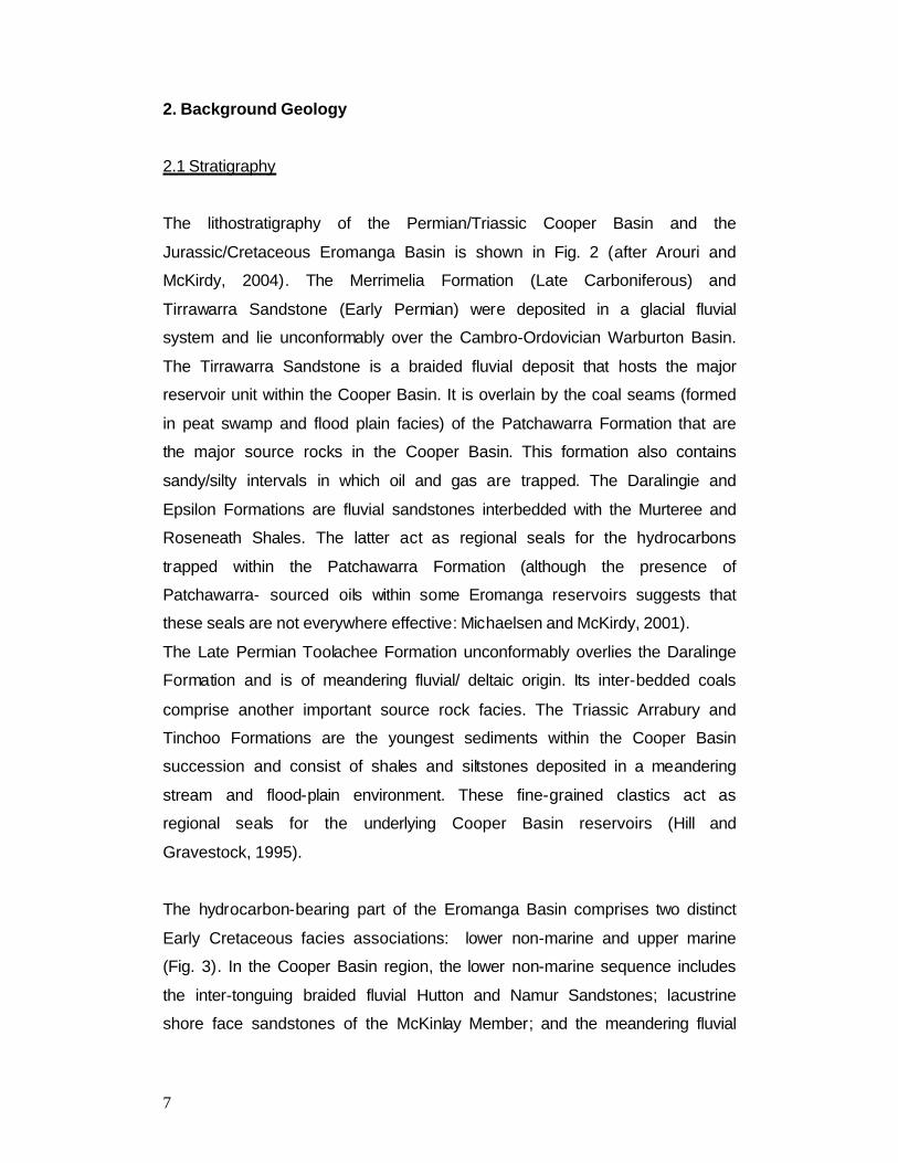
2. Background Geology
2.1 Stratigraphy
The lithostratigraphy of the Permian/Triassic Cooper Basin and the
Jurassic/Cretaceous Eromanga Basin is shown in Fig. 2 (after Arouri and
McKirdy, 2004). The Merrimelia Formation (Late Carboniferous) and
Tirrawarra Sandstone (Early Permian) were deposited in a glacial fluvial
system and lie unconformably over the Cambro-Ordovician Warburton Basin.
The Tirrawarra Sandstone is a braided fluvial deposit that hosts the major
reservoir unit within the Cooper Basin. It is overlain by the coal seams (formed
in peat swamp and flood plain facies) of the Patchawarra Formation that are
the major source rocks in the Cooper Basin. This formation also contains
sandy/silty intervals in which oil and gas are trapped. The Daralingie and
Epsilon Formations are fluvial sandstones interbedded with the Murteree and
Roseneath Shales. The latter act as regional seals for the hydrocarbons
trapped within the Patchawarra Formation (although the presence of
Patchawarra- sourced oils within some Eromanga reservoirs suggests that
these seals are not everywhere effective: Michaelsen and McKirdy, 2001).
The Late Permian Toolachee Formation unconformably overlies the Daralinge
Formation and is of meandering fluvial/ deltaic origin. Its inter-bedded coals
comprise another important source rock facies. The Triassic Arrabury and
Tinchoo Formations are the youngest sediments within the Cooper Basin
succession and consist of shales and siltstones deposited in a meandering
stream and flood-plain environment. These fine-grained clastics act as
regional seals for the underlying Cooper Basin reservoirs (Hill and
Gravestock, 1995).
The hydrocarbon-bearing part of the Eromanga Basin comprises two distinct
Early Cretaceous facies associations: lower non-marine and upper marine
(Fig. 3). In the Cooper Basin region, the lower non-marine sequence includes
the inter-tonguing braided fluvial Hutton and Namur Sandstones; lacustrine
shore face sandstones of the McKinlay Member; and the meandering fluvial
8
overbank and lacustrine facies of the Poolowanna, Birkhead and Murta
Formations
The upper prospective part of the Eromanga succession comprises the
marginal marine Cadna-Owie Formation overlain by the open marine
transgressive and regressive sequences of the Bulldog Shale and Wallumbilla
Formations. The Late Cretaceous non-marine units of the Eromanga Basin
are not oil producing.
2.2 Structure
The structure of the Cooper and Eromanga Basins is dominated by a series of
prominent ridges and troughs(Fig. 2). These structural features determine the
locations of hydrocarbon kitchens (troughs) and possible pathways of
migration into suitable reservoirs and traps (along or adjacent to ridges).
The major structural lows are the Patchawarra and Nappamerri Troughs (Fig.
2). These two features are important depocentres for source rocks. There are
also numerous smaller troughs situated throughout the area, including the
Wooloo Trough, the site of the Arwon and Worrior Fields.
Separating the Patchawarra and Nappemerri Troughs are the Gidgealpa,
Merrimelia, Packsaddle and Innamincka Ridges. These form an arcuate,
northeast trending ridge complex known as the GMI Ridge. Along the
southern edge of the Wooloo Trough there are two symmetrical, flat-topped
features known as the Dunoon and Murteree Ridges from which Permian and
Triassic sediments have been stripped by erosion. Here Jurassic Eromanga
Basin sediments sit directly on the Cambro-Ordovician sequence of the
Warburton Basin (Gravestock and Jensen-Schmidt, 1998)
9
3. Petroleum Systems
3.1 Sources and Reservoirs
The major source and reservoir units within the Cooper/Eromanga succession
are highlighted in Fig. 3. The Patchawarra Formation is the major source rock
within the Cooper Basin. Coals and carbonaceous shales up to 60 meters in
thickness are inter-bedded with fluvial sands, allowing for effective primary
migration of both oil and gas into carrier beds (Kramer et al., 2001). A similar
although less prolific Permian source rock is the Toolachee Formation
(Boreham and Summons, 1999).
The major oil and gas-bearing reservoir within the Cooper Basin is the
Tirrawarra Sandstone, which received its hydrocarbon charge from the coals
and shales of the overlying Patchawarra Formation. Other productive
reservoirs are the intra-formational sands of the Patchawarra and Toolachee
Formations.
Within the Eromanga Basin, the major source rock unit is the mid-Jurassic
Birkhead Formation. Its coals and carbonaceous shales have excellent oil-
source potential (Michaelsen and McKirdy, 1996). Two other important source
units within the basin are the Poolowanna and Murta Formations. The
lacustrine Murta Formation is the youngest organic-rich unit that is capable of
any form of hydrocarbon generation. It is the most dominant oil source rock
along the Murteree Ridge (Michaelsen and McKirdy, 1989; Powell et al.,
1989).
Reservoirs within the Eromanga Basin occur throughout the sequence
between the Poolowanna and Murta Formations. Of these, the Hutton
Sandstone is the most productive, with the Namur Sandstone and McKinlay
Members also being effective oil producers, most notably along the Murteree
Ridge (Arouri et al., 2004).
10
3.2 Trapping Mechanisms and Seals
The major traps of the Cooper Basin are anticlinal and faulted anticlinal
structures. Both have proved to be reliable exploration targets.
Intra-formational shales and coals (also the source facies) form the seals
within the major reservoir units of the Tirrawarra Sandstone and the
Patchawarra and Toolachee Formations. The Permian Murteree and
Roseneath Shales and the fine-grained siliciclastics of the Triassic Arrabury
Formation act as regional seals throughout the Cooper Basin.
Hydrocarbon-bearing structures within the Eromanga Basin are mostly
anticlines with four-way dip closure, and sandstones draping over pre-existing
topographic highs. The seals of the Eromanga Basin consist of intra-
formational silts and shales within the Poolowanna, Birkhead and Murta
Formations (within the Cooper Basin region). In the Poolowanna Trough, the
intra-formational seals of the Poolowanna Formation and siltstones of the
Cadna-owie Formation are effective seals. Throughout the rest of the
Eromanga Basin, the Cadna-owie Formation, Bulldog Shale and Wallumbilla
Formation are effective seals.
Recent exploration along the Cooper Basin zero edge, where the Permo-
Triassic sequence pinches out against basement rocks of the Warburton
Basin, has been successful in locating oil pools within the Jurassic and
Cretaceous sandstones of fields like Christies and Worrior.
11
4. Samples and Analytical Methods
The crude oils selected for analysis are listed in Table 1, along with their well
locations, host formations, producing intervals, flow rates and bulk physical
and chemical properties. In PEL 92, operated by Beach Petroleum in the SW
Patchawarra Trough, two light paraffinic oils (55-57° API) were recovered
from different sands within the Permian Patchawarra reservoir of the Sellicks
Field (Fig. 1). These are compared with the heavier (44-45° API) crudes from
the Jurassic Birkhead and Namur reservoirs in the Christies Field located
some 11 km to the WSW, just beyond the edge of the Cooper Basin.
In PEL 93, operated by Stuart Petroleum in the Wooloo Trough, minor
condensate (52° API) was recovered from the Patchawarra reservoir in the
Worrior Field (Fig. 1). Oils of similar density flowed on drill stem test from the
Jurassic Hutton (53° API) and Birkhead (52° API) reservoirs in the same field;
and with two slightly heavier oils (48° API) produced from the Cretaceous
McKinlay Member (Murta Formation) at Worrior and the nearby Arwon Field in
adjacent PEL 113 (Fig. 1). Since aromatic hydrocarbons comprised only 0.11
wt % of the C12+ fraction of the Worrior-1 (Patchawarra) condensate (Table 2),
and on the reasonable assumption that any Permian charge which reached
these intra-Eromanga reservoirs most likely would have originated in the
Toolachee Formation (see below), their oils instead were compared with
Permian condensate (48-49° API) from the Strzelecki Field, located some 75
km to the ENE on the southern margin of the Nappamerri Trough (Kramer et
al., 2004).
In the case of the darker oils in Table 1 (n = 6), asphaltenes were first
removed by flooding an aliquot (3 g) with excess petroleum ether (90 ml) and
refluxing for 2 hours in a Soxhlet apparatus. Upon cooling, the suspension
was filtered through a Whatman No. 42 filter paper to recover the
asphaltenes. After rotary evaporation to remove the solvent, he the
asphaltene-free (or C12+ maltene) fraction of the oil was ready for column
chromatography.
12
Open-column liquid chromatography (LC) was performed using activated
silica topped by activated alumina. The saturated hydrocarbons were eluted
first with petroleum ether (80 mL), followed by the aromatic hydrocarbons with
petroleum ether and dichloromethane (DCM: 32:48 mL), and finally the resins
with DCM and methanol (28:52 mL). Most of the solvent was removed from
each fraction using a rotary evaporator before its transfer to a weighed vial for
evaporation of the remaining solvent under a capillary stream of N2.
The aromatic fractions were submitted to Geotechnical Services Pty Ltd,
Welshpool, WA for analysis by gas chromatography-mass spectrometry (GC-
MS) in SIM mode using a HP 6890 GC fitted with a ZB-5 column (60m x 0.25
mm i.d. x 0.25 •m film thickness) and interfaced to a HP 5973 mass selective
detector. Inlet conditions: pulsed splitless injection at 50 psi; injector
temperature, 250°C. Oven conditions: 50-300°C at 3°/min. The following ions
were monitored: m/z 170 (trimethylnaphthalenes), m/z 178 (phenanthrene),
m/z 192 (methylphenanthrenes), m/z 206 (dimethylphenanthrenes) and m/z
219 (retene). The data were processed using the HP Chemstation software,
allowing peaks to be integrated and molecular parameters calculated. The
thermal maturity of each of the oils, expressed as calculated vitrinite
reflectance (%Rc), was determined using Radke and Welte’s (1983)
calibration of the methylphenanthrene index (MPI-1).
13
5. Results and discussion
5.1 General remarks
The C12+ bulk compositions of the oils as determined by deasphaltening and
LC are summarised in Table 2. Saturates contents are typically lower for the
Permian oils and condensate (26-60% w/w) than for the oils from Jurassic and
Cretaceous reservoirs (41-83%). Aromatic hydrocarbons comprise 2-12%,
except in the atypical Worrior-1 (DST 4, Patchawarra) condensate, which
therefore was excluded from further analysis. Examples of the selected ion
chromatograms of the aromatic hydrocarbons used to characterise the
maturity and source affinity of these oils are shown in Figs 4 and 5. Aromatic
source and maturity parameters, the primary focus of this study, are
presented in Tables 3 and 4, along with the equivalent data on the Strzelecki-
10 (Toolachee) condensate (Kramer et al., 2004) and the end-member
Patchawarra and Birkhead oils from the Moorari Field in the central
Patchawarra Trough analysed by Arouri and McKirdy (2005). Fig. 6 comprises
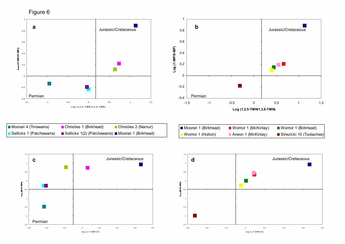
a set of source affinity cross-plots based on the Araucariacean biomarker
ratios of Alexander at al. (1988), whereas Fig. 7 illustrates the position of the
six Eromanga-hosted oils from the Christies, Worrior and Arwon Fields on
mixing curves derived from the source-maturity cross-plot of Michaelsen and
McKirdy (2001), as re-calibrated by Arouri and McKirdy (2005).
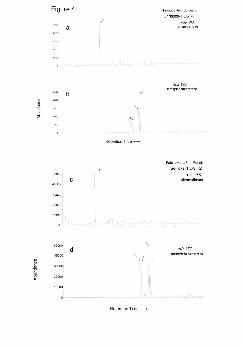
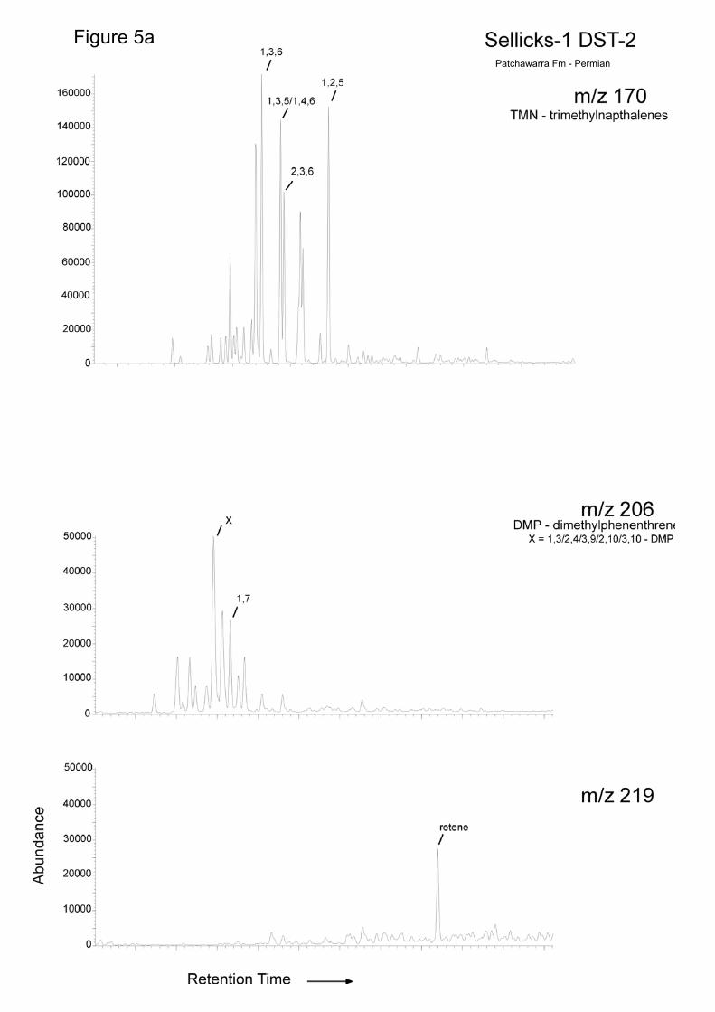
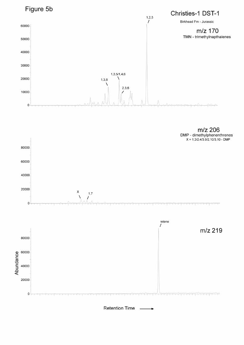
5.2 Thermal maturity and source affinity
Sellicks Field, Southwestern Patchawarra Trough
Not surprisingly, given that they come from adjacent sands in the Patchawarra
Formation, the two Permian oils recovered from Sellicks-1 have the same
maturity (0.87-0.88% Rc). This is important because it signifies that they
belong to Family 2, the second of the two Permian oil types identified by
Michaelsen and McKirdy (2001) in the Cooper Basin. Both Sellicks-1
(Patchawarra) oils plot within or near the lower left quadrant of the source
affinity diagrams (Fig. 6a,c), confirming their intra-Permian origin as first

14
proposed by Altman and Gordon (2004). However, it is worth noting that they
plot well away from the Moorari-4 (Tirrawarra) crude, which is a typical Family
1 oil.
The latter oil was used as an end-member Permian oil by Michaelsen and
McKirdy (2001) and Arouri and McKirdy (2004) when defining their mixing
curves. However, the Sellicks-1 (Patchawarra) oil obviously is a more
appropriate Permian end-member when determining the mixing ratios of the
oils in the stacked Eromanga reservoirs up-dip in the Christies Field (see
below).
Christies Field, Southwestern Patchawarra Trough
Here oil is produced from two Jurassic reservoirs. Oil in the Birkhead at
Christies-1 (0.61% Rc) is slightly less mature than that in the overlying Namur
at Christies-2 (0.65% Rc), and both are appreciably less mature than the oil in
the Patchawarra reservoir of the Sellicks Field.
Inspection of the two source affinity diagrams (Fig. 6a,c) reveals that the
Birkhead and Namur crudes plot within or near the upper right quadrant
consistent with an origin (at least in part) from source rocks of Jurassic or
Cretaceous age, based on the Araucariacean biomarker criteria of Alexander
et al. (1988). However, they lie between the end-member Birkhead oil from
Moorari-1 and the Patchawarra oils from Sellicks-1. This is significant
because it suggests that they may be mixtures of Cooper and Eromanga-
sourced hydrocarbons, and not entirely derived from the Patchawarra
Formation as claimed by Altman and Gordon (2004).
Arwon and Worrior Fields, Western Wooloo Trough
Oils pooled in the Cretaceous McKinlay Member at Arwon-1 and Worrior-1
have maturities of 0.62 and 0.63% Rc, respectively. As such they are slightly
less mature than those in the underlying Jurassic Birkhead and Hutton
reservoirs of the Worrier Field (both 0.67% Rc). The relative abundances of
15
their Araucariacean biomarkers denote a Jurassic or Cretaceous origin for all
these oils (Fig. 6b,d). However, in both source affinity cross-plots, it is worth
noting that the proximity of the oil to the Permian quadrant is inversely related
to the age of its reservoir. In other words, the extent of a Permian contribution
to these oil pools is likely to be Hutton > Birkhead > McKinlay. The observed
maturity and source affinity of the oils within the McKinlay Member at Arwon-1
and Worrior-1 could mean one of two things: their hydrocarbons could have
(1) been derived from marginally mature source beds in the overlying Murta
Formation (Michaelsen and McKirdy, 1989; Powell et al., 1999) and migrated
down into the McKinlay reservoir, or (2) represent an early charge that was
displaced upwards from the underlying Birkhead and/or Hutton reservoirs.
5.3 Mixing ratios
Southwestern Patchawarra Trough
Although their Araucariacean biomarker signatures indicate that the Birkhead
and Namur oils in the Christies Field are of post-Permian (probably Jurassic) origin (Fig. 6a,c), the 2-MP/1-MP versus 1-MP/9-MP cross-plot (Fig. 7a)
reveals that they are mixtures of Permian and Jurassic oil. In fact,
approximately 60% of the Birkhead oil and 70% of the Namur oil is of Permian
origin. This Permian contribution most likely originated from oil-prone coals of
the Patchawarra Formation in a hydrocarbon kitchen some 18-21 km to the
east (Fig. 8a). The inferred location of the kitchen is based on the assumption
that the Permian oil is of the same source affinity and maturity as the Family 2
crude trapped in the Patchawarra reservoir at Sellicks-1.
Western Wooloo Trough
A similar oil-mixing scenario is apparent in the Eromanga reservoirs at Arwon-
1 and Worrior-1 (Fig. 7b). Here the Permian contribution (in this case from
coals of the Toolachee Formation) increases from approximately 60% in the
McKinlay, through 65% in the Birkhead, to 70% in the Hutton.
16
5.4 Migration
Oil maturities based on MPI-1 and expressed as equivalent vitrinite
reflectance of the source rock at the time of primary migration (Rc %: Table
3), in conjunction with isoreflectance maps for the two principal source rock
units (Fig. 8a,b), allow delineation of hydrocarbon kitchens and likely
migration pathways.
Southwestern Patchawarra Trough
Oil pooled within the Patchawarra Formation at Sellicks-1 is of Permian
source-affinity and hence most likely was generated and expelled from intra-
formational coal. The oil’s maturity (0.87-0.88% Rc) is greater than that of coal
in the host reservoir (~0.76% Ro: Fig. 8a), showing that it is clearly out of
place.
For the Sellicks Field, the hydrocarbon kitchen is located to the west of the
trap, and its oil has migrated at least 10 km up dip to its current location (Fig.
8a). This is only a minimum migration distance because the oil could have
originated from further away when coals, now of higher maturity (or rank),
were less deeply buried.
Because Permian oil has mixed with indigenous Jurassic oil in the Eromanga
reservoirs of the Christies Field, we can infer that oil from the same
hydrocarbon kitchen has continued migration along the same pathway. For
this oil, a minimum migration distance of 23-24 km is indicated.
The Eromanga input in to the Birkhead and Namur oil pools of the Christies
Field is presumed to have come from the dominant Jurassic (intra-Birkhead)
source rock. Thus, again, the calculated maturities of these two oils (0.61-
0.65% Rc: Table 3) and the isoreflectance map of the Birkhead Formation
(Fig. 8b) can be used to determine how far the Jurassic oil charge has
migrated. Because isoreflectance contours typically follow structural trends
(higher maturity in deeper areas), two possible migration pathways can be
17
interpreted (Fig. 8b). The southern route represents a distance of 30-32 km;
and the northern route a distance of ~18 km.
Western Wooloo Trough
No samples were analysed to provide source and maturity information on the
condensate from the Patchawarra Formation at Worrior-1.Moreover, since the
Permian charge into the Eromanga reservoirs, here and at Arwon-1, is
interpreted to have come from coals of the Toolachee Formation within the
Wooloo Trough, migration distances cannot be calculated because no
isoreflectance map was available for this formation. Only the Eromanga
(Birkhead-sourced) inputs to the Hutton, Birkhead and McKinlay reservoirs of
these fields can be evaluated in terms of their migration distances.
Due to their stratigraphic proximity and identical thermal maturity (0.67% Rc:
(Table 3), it is likely that the Jurassic component of the Hutton and Birkhead
oil pools originated from the same source rock and hydrocarbon kitchen. Two
potential kitchen areas are identified in the Birkhead Formation (Fig. 8b). Oil
expelled from the western kitchen would have to have migrated only 4-5 km to
reach the Jurassic reservoirs of the Worrior Field. Another hydrocarbon
kitchen lies to the northeast of Arwon-1. Southwesterly migration from this
kitchen of an earlier charge (0.62-0.63% Rc) from this kitchen would have
travelled a minimum distance of ~18 km to reach the McKinlay reservoir at
Arwon-1, and a further 6 km into the same reservoir at Worrior-1 (i.e. a total
distance of ~24 km). Alternatively, the McKinlay reservoir in the Worrior Field
could have been charged by Jurassic hydrocarbons that were expelled from
local Birkhead source rocks and migrated vertically up one of the faults
bounding the Worrior structure (Fig. 10).
5.5 Summary migration models
18
Southwest Patchawarra Trough
Figure 9 shows a cross section through the Christies and Sellicks Fields. The
Permian hydrocarbon kitchen is situated within the deeper sediments of the
Patchawarra Formation. Oil expelled from the coal source rock migrated up
dip beneath the intra-Patchawarra seal and entered the Hutton-Birkhead
sequence past the erosional edge of the seal. The Christies reservoirs are
located beyond the Cooper Basin margin. The presence of oil in the Namur
Sandstone implies that the Birkhead seal has leaked, allowing migration up
section into younger Eromanga reservoirs.
There is, however, a second source rock in the area allowing migration from a
Jurassic (probable Birkhead) source into the reservoirs. The Birkhead oil
kitchen is situated to the east of the Christies and Sellicks Fields. Its oil
migrated westward, underneath the intra-Birkhead seal into the Birkhead and
Namur reservoirs at Christies.
Western Wooloo Trough
The E-W seismic section through Worrior-1 and Arwon-1 (Fig. 10), illustrates
the stratigraphic constraints on the migration of oil from the Birkhead
Formation into the overlying McKinlay Member or downwards into the Hutton
Sandstone. Migration into the McKinlay could have occurred from its overlying
source rock, the Murta Member. However due to the presence of faults within
the Worrior structure, it is more likely that oil reached its McKinlay reservoir by
migrating up the fault to the rest of the field. These hydrocarbons could have
entered the trap from both the east and the west (Fig. 10).
19
Conclusions1. The maturity of the oil from the Patchawarra Formation at Sellicks-1 (0.87-
0.88%Rc) signifies that it belongs to the second of two Permian oil families
identified by Michaelsen and McKirdy (2001) within the Cooper Basin. Oils
within the Jurassic reservoirs at Christies-1 and –2 are less mature (0.61%Rc,
Birkhead and 0.65%Rc, Namur) and are of a mixed Jurassic-Permian source
affinity.
2. Oils within the Cretaceous McKinlay Member at Arwon-1 and Worrior-1
have maturities of 0.62 to 0.63%Rc making them less mature than those in
the underlying Jurassic Birkhead and Hutton reservoirs at Worrior-1
(0.67%Rc). Again, these Eromanga-hosted oils are of a mixed source affinity
3. The Sellicks Field on the SW flank of the Patchawarra Trough contains
Family 2 Permian oil generated from coals within the early Permian
Patchawarra Formation. This oil has also migrated into the Birkhead and
Namur reservoirs of the Christies Field where it mixed with indigenous
Jurassic oil and makes up 60-70% of the total charge.
4. Mixing in Jurassic and Cretaceous reservoirs within the Western Wooloo
Trough occurred between Permian oil from the Toolachee Formation and
Jurassic oil from the Birkhead Formation, with Permian input increasing up the
section (Hutton 70%, Birkhead 65%, McKinlay 60%).
5. Oil from the Patchawarra Trough migrated 10 km up dip into the Sellicks
Field and continued along the same pathway into the Birkhead and Namur
reservoirs of the Christies Field, a total migration distance of at least 23-24
km. The Eromanga Birkhead input into the Jurassic reservoirs has found two
possible migration pathways: a southern route totalling 30-32 km, and a
northern route over a distance of ~18 km.
6. The Jurassic component of the Hutton, Birkhead and McKinlay reservoirs of
the Arwon and Worrior fields most likely originated in the Birkhead Formation
and could have come from two possible source kitchens. Migration from the

20
kitchen located west of the Worrior structure would have occurred over 4-5km.
However, hydrocarbons from the eastern kitchen would have migrated at least
24 km before reaching the Worrior Field.

21
Acknowledgments
This research project was made possible by the generous financial support of
Beach Petroleum Limited.
David McKirdy for his guidance, patience, knowledge and support for making
this a rewarding and fun project.
I’d like to thank Janet Skinner (Beach Petroleum) and Maris Zwigulis (Stuart
Petroleum) for information and advice during the project, and the
management of their companies for the oil samples analysed in this study.
Lynn Webster (OGBA Group, University of Adelaide) provided patient
guidance in the laboratory and Geotechnical Services Pty Ltd, WA undertook
the GC-MS analysis of the aromatic fractions.
I’d also like to thank Chrissy, Dee, Stacey and DC for allowing me to share
with them my love and loyalty for ‘great’ music. All year. Whether they liked it
or not.
And last, but definitely not least all my family, for all their love and support
over the last few years.
22
References
Alexander, E.M, 1996. Reservoirs and seals In: Alexander, E.M. and Hibburt,
J.E. (Eds), The petroleum geology of South Australia. Vol. 2: Eromanga
Basin. Department of Mines and Energy South Australia, Report Book 96/20,
141-148.
Alexander, R., Larcher, A.V., Kagi, R.I. and Price, P.L., 1988. The use of
plant-derived biomarkers for correlation of oil with source rocks in the
Cooper/Eromanga Basin system, Australia. The APEA Journal 28, 310–325.
Altmann, M.J., Gordon, H.M., 2004. Oil on the Patchawarra Flank – some
implications from the Sellicks and Christies oil discoveries, Petroleum
Exploration Society of Australia, Eastern Australasian Basins Symposium II,
Adelaide, September 2004, pp.29-34
Arouri, K.R., McKirdy, D.M., Schwark, L., Leythaeuser, D. and Boult, P.J.,
2004. Accumulation and mixing of hydrocarbons in oil fields along the
Murteree Ridge, Eromanga Basin, South Australia. Organic Geochemistry 35,
1597-1618.
Arouri, K.R., McKirdy, D.M., 2005. The behaviour of aromatic hydrocarbons in
artificial mixtures of Permian and Jurassic end-member oils: application to in-
reservoir mixing in the Eromanga Basin, Australia. Organic Geochemistry 36,
105-115.
Boreham, C.J., Hill, A.J., 1998. Source rock distribution and hydrocarbon
geochemistry. In: Gravestock, D.I., Hibburt, J.E. and Drexel, J.F. (Eds), The
petroleum geology of South Australia. Vol. 4: Cooper Basin, Department of
Primary Industries and Resources South Australia, Report Book 98/9, 131–
144.
23
Boreham, C.J. and Summons, R.E., 1999. New insights into the active
petroleum systems in the Cooper and Eromanga Basins, Australia. The
APPEA Journal 39, 263–296.
Burckhardt, D., 1990. Base Patchawarra Formation and Mid Birkhead
Formation (P.E.L. 5 & 6) 1:250 000 Isoreflectance Maps (Santos Ltd)
Gravestock, D.J., Jensen-Schmidt, B., 1996 Structural setting In: Gravestock,
D.I., Hibburt, J.E. and Drexel, J.F. (Eds), The petroleum geology of South
Australia. Vol. 4: Cooper Basin. Department of Primary Industries and
Resources South Australia, Report Book 98/9, 157–179.
Heath, R., McIntyre, S., Gibbins, N., 1989. A Permian origin for Jurassic
reservoired oil in the Eromanga Basin. In: O’Neil, B.J. (Ed.), The Cooper and
Eromanga Basins, Australia. Proceedings of PESA, SPE, ASEG (SA
Branches), Adelaide, 405–416.
Hill, A.J., Gravestock, D.I., 1995. Cooper Basin: Structure and Setting. In:
Drexel, J.F., Preiss, W.V. (Eds.), The Geology of South Australia, Vol. 2 The
Phanerozoic. Geological Survey of South Australia, Bulletin 54, pp. 78-87.
Jenkins, C.C., 1989. Geochemical correlations of source rocks and crude oils
from the Cooper and Eromanga Basins. In: O’Neil, B.J. (Ed), The Cooper and
Eromanga Basins, Australia. Proceedings of PESA, SPE, ASEG (SA
Branches), Adelaide, 525–540.
Kramer, L., McKirdy, D.M., Arouri, K.R., Schwark, L., Leythaeuser, D., 2004.
Constraints on the hydrocarbon charge history of sandstone reservoirs in the
Strzelecki Field, Eromanga Basin, South Australia. Petroleum Exploration
Society of Australia, Eastern Australasian Basins Symposium II, Adelaide,
September 2004
Michaelsen, B.H., McKirdy, D.M., 1989. Organic facies and petroleum
geochemistry of the lacustrine Murta Member (Mooga Formation) in the
24
Eromanga Basin, Australia. In: O’Neil, B.J. (Ed), The Cooper and Eromanga
Basins, Australia. Proceedings of Petroleum Exploration Society of Australia,
Society of Petroleum Engineers, Australian Society Exploration Geophysicists
(SA Branches), Adelaide, pp. 541–558.
Michaelsen, B.H., McKirdy, D.M., 1996. Source rock distribution and
hydrocarbon geochemistry. In: Alexander, E.M., Hibburt, J.E. (Eds) The
Petroleum Geology of South Australia, vol. 2: Eromanga Basin. Department of
Mines and Energy South Australia, Report Book 96/20, 101–110.
Michaelsen, B.H., McKirdy, D.M., 2001. Migration and mixing of oils in the
Cooper and Eromanga Basins, Central Australia. In: Hill, K.C. and Bernecker,
T. (Eds), Eastern Australasian Basins Symposium, a refocused energy
perspective for the future. Petroleum Exploration Society of Australia, Special
Publication, pp. 289–300.
Powell, T.G., Boreham, C.J., McKirdy, D.M., Michaelsen, B.H., Summons,
R.E., 1989. Petroleum geochemistry of the Murta Member, Mooga Formation
and associated oils, Eromanga Basin, Australia. APEA Journal 29 (1), 114–
129.
Radke, M., Welte, D.H., 1983. The methylpnenanthrene index (MPI): a
maturity parameter based on aromatic hydrocarbons. In: Bjøroy, M. et al.
(Eds.), Advances in Organic Geochemistry 1981. Wiley, Chichester, pp. 504-
512.
Radke, M., Willsch, H., Leythaeuser, D., Teichmuller, M., 1982. Aromatic
components of coal: relation of distribution patterns to rank. Geochimica et
Cosmochimica Acta 46, 1831-1848.
Tupper, N.P., Burckhardt, D.M., 1990. Use of the methylphenenthrene index
to characterize expulsion of Cooper and Eromanga Basin oils. APEA Journal
30 (1), 375-385.
25
Figure and Table captions
Figure 1. Location of Beach Petroleum’s,Sellicks’ and Christies Fields and
Stuart Petroleum’s Worrior and Arwon Fields.
Figure 2. Major structures within the South Australian sector of the Cooper-
Eromanga Basin province (from Gravestock and Jensen-Schmitt, 1996)
Figure 3. Lithostratigraphy of the Cooper and Eromanga Basins (adapted from
Arouri and McKirdy, 2004) Insets show the locations of the drill stem tests that
yielded the oils examined in this study.
Figure 4. SIM mass chromatograms of phenanthrene (m/z 178) and
methylphenanthrenes (m/z 192) in selected DST oils: (a,b) Christies-1,
Birkhead Fm and (c,d) Sellicks-1, Patchawarra Formation.
Figure 5. SIM mass chromatograms, trimethylnaphthalenes (m/z 170),
dimethylphenanthrenes (m/z 219), of hydrocarbons in selected DST oils (a)
Christies-1, Birkhead Fm and (b) Sellicks-1, Patchawarra Formation
Figure 6. Source affinity plots (after Alexander at al., 1988) of selected oils (a,
c) Christies and Sellicks Fields and (b, d) Worrior and Arwon Fields.
Figure 7. Cross-plot of 1-MP/9-MP versus 2-MP/1-MP incorporating the
calibrated mixing curve from Arouri and McKirdy, (2004): (a) Christies and
Sellicks Fields and (b) Worrior and Arwon fields.
Figure 8. Vitrinite isoreflectance maps of the (a) base Patchawarra Formation
and (b) mid-Birkhead Formation showing well locations and inferred migration
pathways. Maps modified from Burckhardt (1990).
Figure 9. Schematic cross-section through the Patchawarra Trough and the
Christies-1 and Sellicks-1 well locations, showing hydrocarbon migration
pathways and oil kitchen locations (adapted from Altmann and Gordon, 2002)
26
Figure 10. Schematic cross-section through the Arwon-1 and Worrior-1 well
locations, showing hydrocarbon migration pathways and oil kitchen locations
(Arwon Well Completion Report, Stuart Petroleum).
Table 1. Oil sample data and locations for Christies-1 and 2 and Sellicks-1
(Patchawarra Trough), and Worrior-1 and Arwon-1 (Wooloo Trough) taken
from well completion reports.
Table 2. C12+ bulk composition of crude oils as determined by deasphaltening
(where indicated) and open-column liquid chromatography.
Table 3. Aromatic maturity parameters of crude oils. Data on oils from
Strzlecki-10 (Kramer et al., 2004) and Moorari-1 and 4 (Arouri and McKirdy,
2004) included for comparison.
Table 4. Aromatic source parameters of crude oils. Data on oils from
Strzlecki-10 (Kramer et al., 2004) and Moorari-1 and -4 (Arouri and McKirdy,
2004) included for comparison.
Figure 1
Figure 2
Worrior/Arwon Field
Christies/Sellicks Field
Figure 3
Birkhead Fm - Jurassic
Patchawarra Fm - Permian
Figure 4
a
b
c
d
Patchawarra Fm - Permian
Figure 5a
Birkhead Fm - Jurassic
Figure 5b
-‐ 0.4
-‐0.2
0
0.2
0.4
0.6
0.8
1
-‐1.5 -‐1 -‐0.5 0 0.5 1 1.5
L o g ( 1, 2 , 5 -‐ T MN /1, 3 , 6 -‐ T MN )
Moorari 4 (Tirrawarra) Christies 1 (Birkhead) Christies 2 (Namur)Sellicks 1 (Patchawarra) Sellicks 1(2) (Patchawarra) Moorari 1 (Birkhead)
-‐2.5
-‐2
-‐1.5
-‐1
-‐0.5
0
0.5
1
1.5
-‐0.6 -‐0.4 -‐0.2 0 0.2 0.4 0.6 0.8
L og ( 1 , 7 -‐ D MP / X )
-0.4
-0.2
0
0.2
0.4
0.6
0.8
1
-1.5 -1 -0.5 0 0.5 1 1.5
Log (1,2,5-TMN/1,3,6-TMN)
Log
(1-M
P/9-
MP)
Moorari 1 (Birkhead) Worrior 1 (McKinlay) Worrior 1 (Birkhead)Worrior 1 (Hutton) Arwon 1 (McKinlay) Strezlcki 10 (Toolachee)
-‐2.5
-‐2
-‐1.5
-‐1
-‐0.5
0
0.5
1
1.5
-‐0.6 -‐0.4 -‐0.2 0 0.2 0.4 0.6 0.8
L og ( 1 , 7 -‐ DMP / X )
a
c
b
d Jurassic/Cretaceous
Permian
Permian
Jurassic/Cretaceous Jurassic/Cretaceous
Permian
Jurassic/Cretaceous
Figure 6
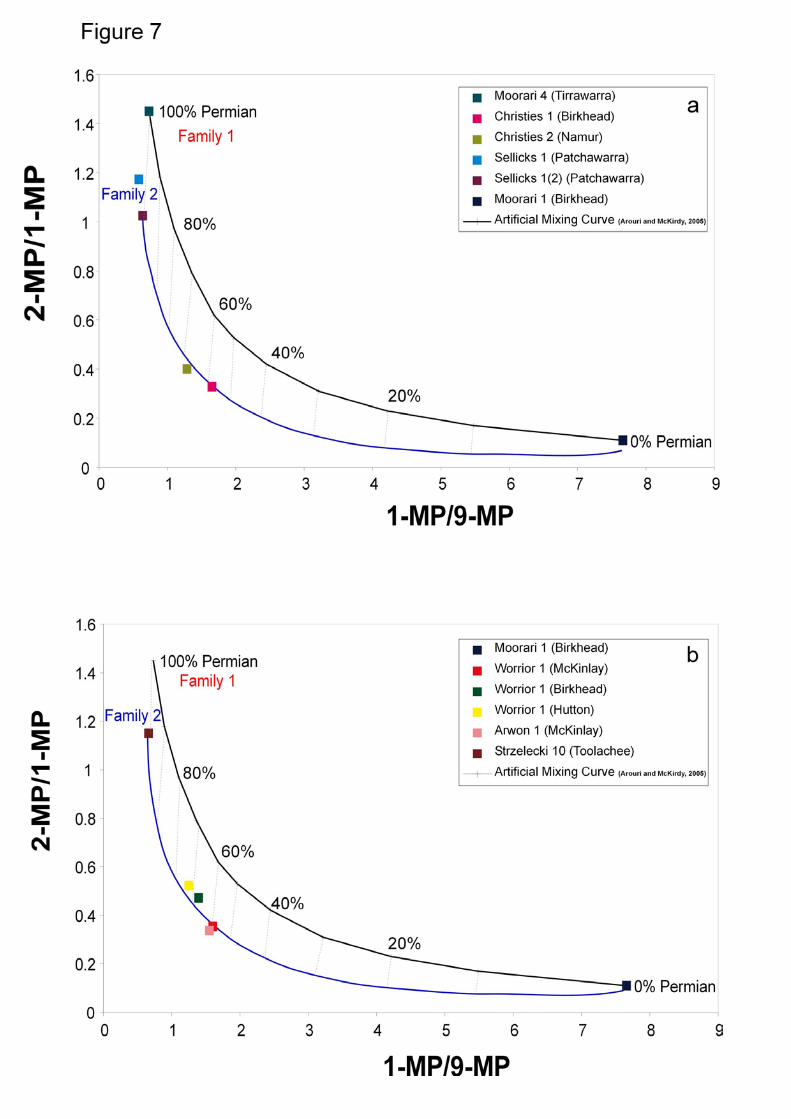
Figure 8a
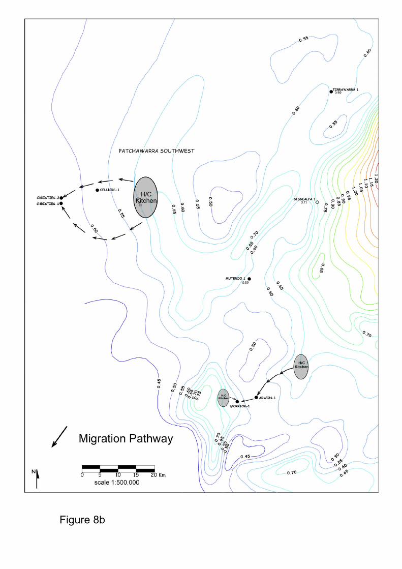
Figure 8b
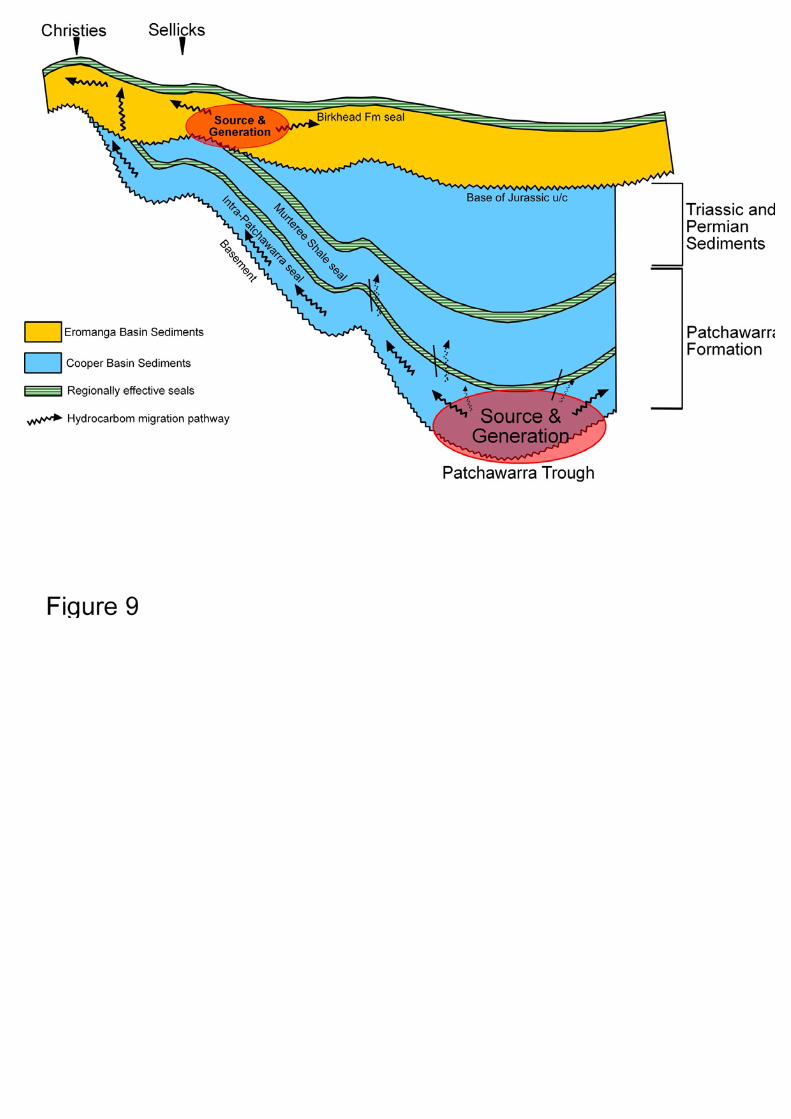
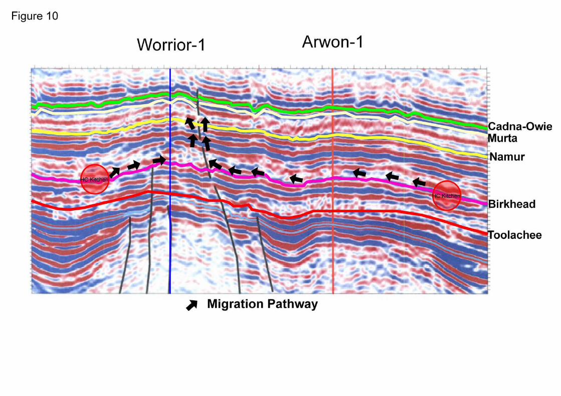
Table 1
Well DST* Depth interval (m) Location Formation Name API
Gravity (20oC)
Pour Point ( oC)
Sulphur Content (wt%)
Kinematic Viscosity @ 40oC (cSt)
Flow Rate (bopd)
Sellicks-1 1 2058.1 – 2071.7 Lat:27o55’48.47”S Long:139 o28’35.27”E
Patchawarra 57.22 N/A 0.04 0.96 1915 2 2076.5 - 2086 Patchawarra 54.50 N/A N/A N/A N/A
Christies-1 1 1607.7 – 1622 Lat: 27o58’47.39”S Long: 139 o22’22.97”E Birkhead 45.40 15.00 0.11 2.64 246
Christies-2 1 1344.4 – 1352 Lat: 27o58’53.82”S Long: 139 o22’15.83”E Namur 44.04 21.00 0.03 3.89 1773
Arwon-1 1 1357.8 - 1368 Lat: 28o24’21.16”S Long: 139 o50’02.72”E McKinlay 48.39 3 N/A 2.267 60
Worrior-1
1 1328 – 1335 Lat: 28o25’06.94”S Long: 139 o48’42.89”E
McKinlay 48.18 6 N/A 2.54 1600 2 1553 – 1569 Birkhead 52.19 3 N/A 1.55 200 3 1579 - 1585 Hutton 52.5 -9 N/A 1.01 2880 4 1712-1719 Patchawarra 52.2 N/A N/A N/A 60
*Drill Stem Test
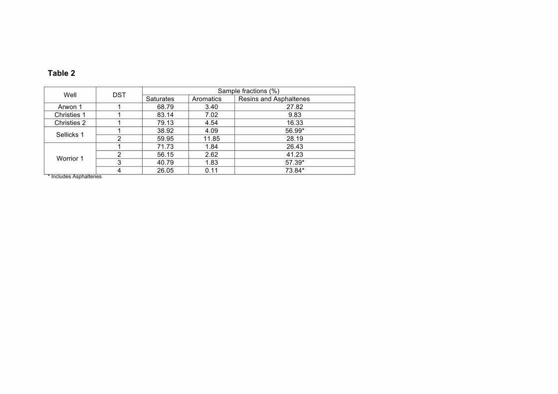
Table 2
Well DST Sample fractions (%) Saturates Aromatics Resins and Asphaltenes
Arwon 1 1 68.79 3.40 27.82 Christies 1 1 83.14 7.02 9.83 Christies 2 1 79.13 4.54 16.33
Sellicks 1 1 38.92 4.09 56.99* 2 59.95 11.85 28.19
Worrior 1
1 71.73 1.84 26.43 2 56.15 2.62 41.23 3 40.79 1.83 57.39* 4 26.05 0.11 73.84*
* Includes Asphaltenes
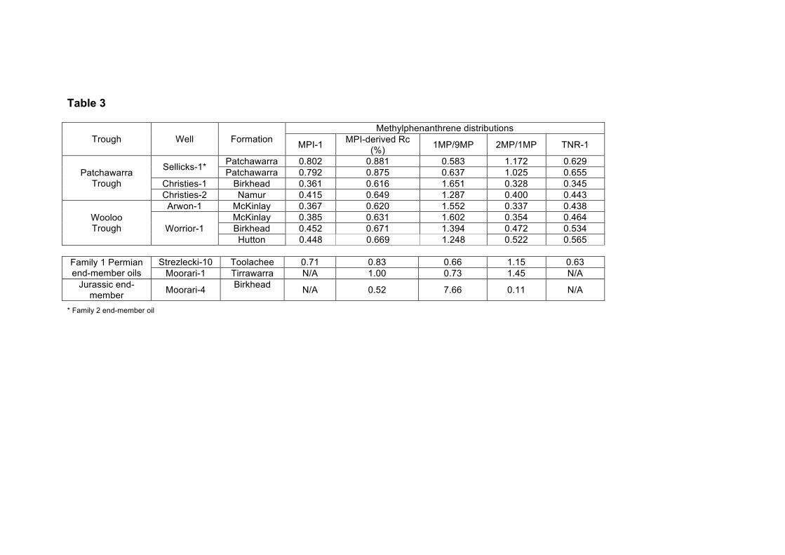
Table 3
* Family 2 end-member oil
Trough Well Formation Methylphenanthrene distributions
MPI-1 MPI-derived Rc (%) 1MP/9MP 2MP/1MP TNR-1
Patchawarra Trough
Sellicks-1* Patchawarra 0.802 0.881 0.583 1.172 0.629 Patchawarra 0.792 0.875 0.637 1.025 0.655
Christies-1 Birkhead 0.361 0.616 1.651 0.328 0.345 Christies-2 Namur 0.415 0.649 1.287 0.400 0.443
Wooloo Trough
Arwon-1 McKinlay 0.367 0.620 1.552 0.337 0.438
Worrior-1 McKinlay 0.385 0.631 1.602 0.354 0.464 Birkhead 0.452 0.671 1.394 0.472 0.534 Hutton 0.448 0.669 1.248 0.522 0.565
Family 1 Permian end-member oils
Strezlecki-10 Toolachee 0.71 0.83 0.66 1.15 0.63 Moorari-1 Tirrawarra N/A 1.00 0.73 1.45 N/A
Jurassic end-member Moorari-4 Birkhead N/A 0.52 7.66 0.11 N/A
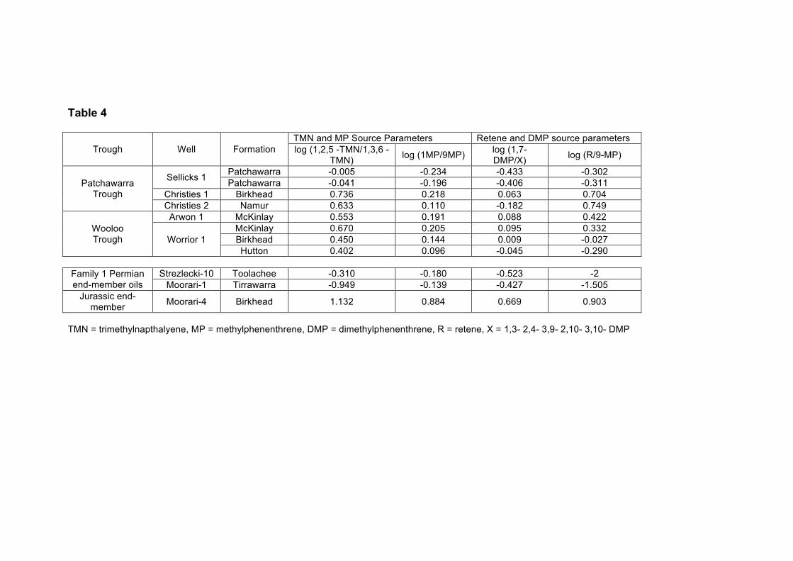
Table 4
Trough Well Formation TMN and MP Source Parameters Retene and DMP source parameters log (1,2,5 -TMN/1,3,6 -
TMN) log (1MP/9MP) log (1,7-DMP/X) log (R/9-MP)
Patchawarra Trough
Sellicks 1 Patchawarra -0.005 -0.234 -0.433 -0.302 Patchawarra -0.041 -0.196 -0.406 -0.311
Christies 1 Birkhead 0.736 0.218 0.063 0.704 Christies 2 Namur 0.633 0.110 -0.182 0.749
Wooloo Trough
Arwon 1 McKinlay 0.553 0.191 0.088 0.422
Worrior 1 McKinlay 0.670 0.205 0.095 0.332 Birkhead 0.450 0.144 0.009 -0.027 Hutton 0.402 0.096 -0.045 -0.290
Family 1 Permian end-member oils
Strezlecki-10 Toolachee -0.310 -0.180 -0.523 -2 Moorari-1 Tirrawarra -0.949 -0.139 -0.427 -1.505
Jurassic end-member Moorari-4 Birkhead 1.132 0.884 0.669 0.903
TMN = trimethylnapthalyene, MP = methylphenenthrene, DMP = dimethylphenenthrene, R = retene, X = 1,3- 2,4- 3,9- 2,10- 3,10- DMP