Embed Size (px)
Citation preview
Hurricane Modeling at NCEP
Hurricane Modeling at NCEP
Naomi Surgi (et al.)Naomi Surgi (et al.)
NCEP/Environmental Modeling CenterNCEP/Environmental Modeling CenterWHERE AMERICA’S CLIMATE AND WEATHER SERVICES BEGINWHERE AMERICA’S CLIMATE AND WEATHER SERVICES BEGIN

OVERVIEW
GFDL Upgrades
HWRF Development
HWRF preliminary results
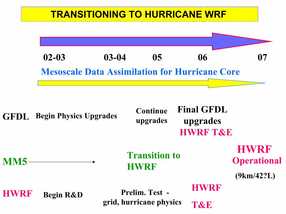
TRANSITIONING TO HURRICANE WRF
02-03 03-04 05 06 07Mesoscale Data Assimilation for Hurricane Core
GFDL
MM5
Begin Physics Upgrades
Prelim. Test -grid, hurricane physics
HWRF
T&EHWRF
Operational(9km/42?L)
Final GFDL upgrades
HWRF T&E
Begin R&D
Transition to HWRF
HWRF
Continue upgrades
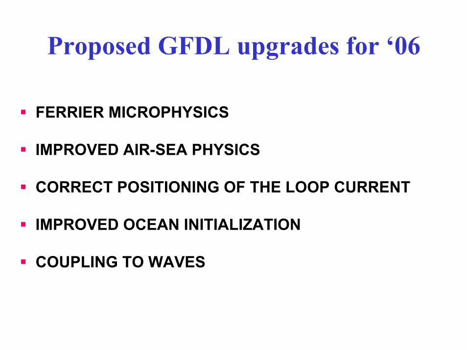
Proposed GFDL upgrades for ‘06
FERRIER MICROPHYSICS
IMPROVED AIR-SEA PHYSICS
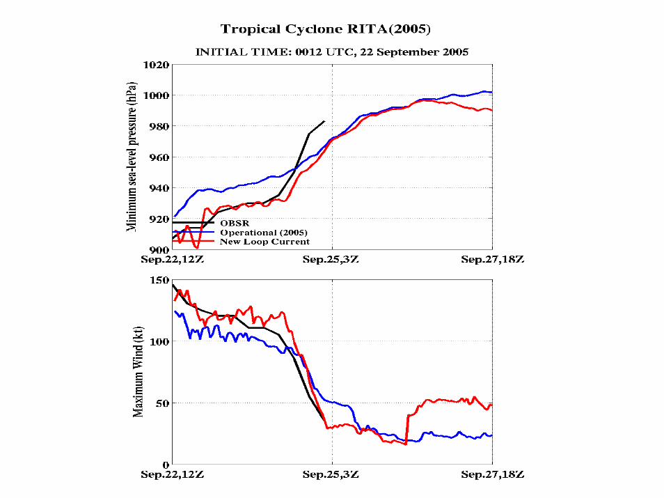
CORRECT POSITIONING OF THE LOOP CURRENT
IMPROVED OCEAN INITIALIZATION
COUPLING TO WAVES
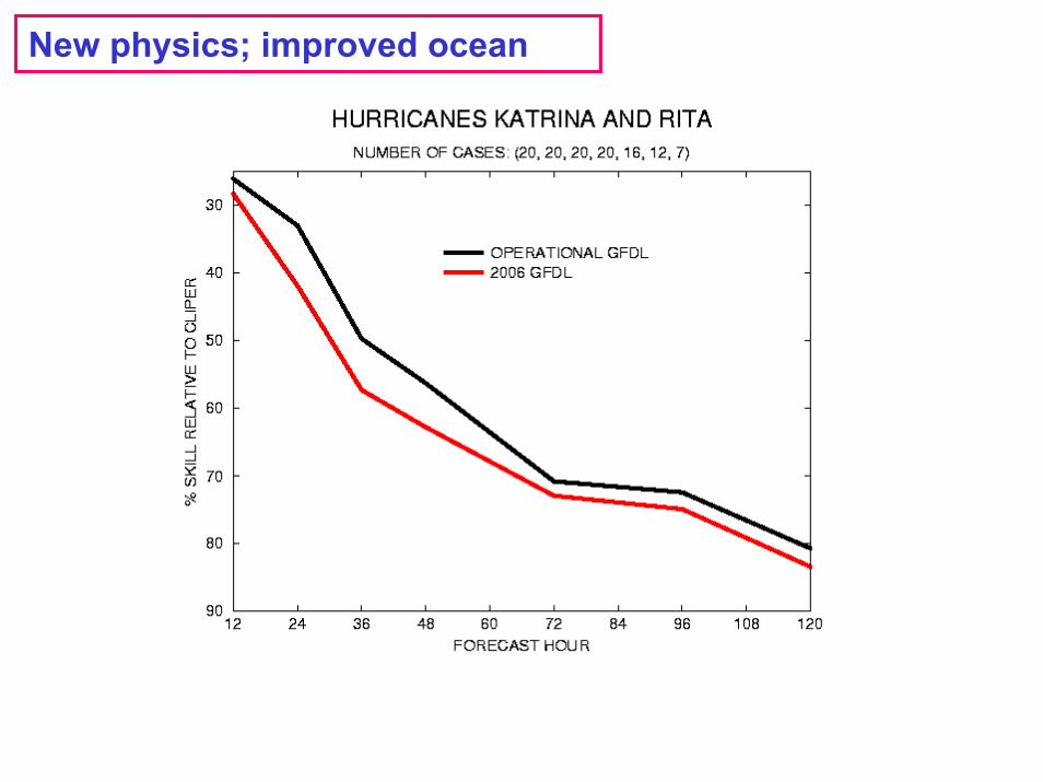
New physics; improved ocean
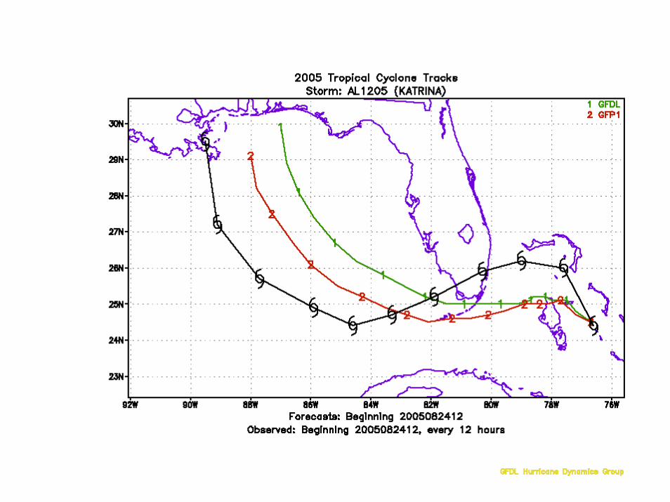
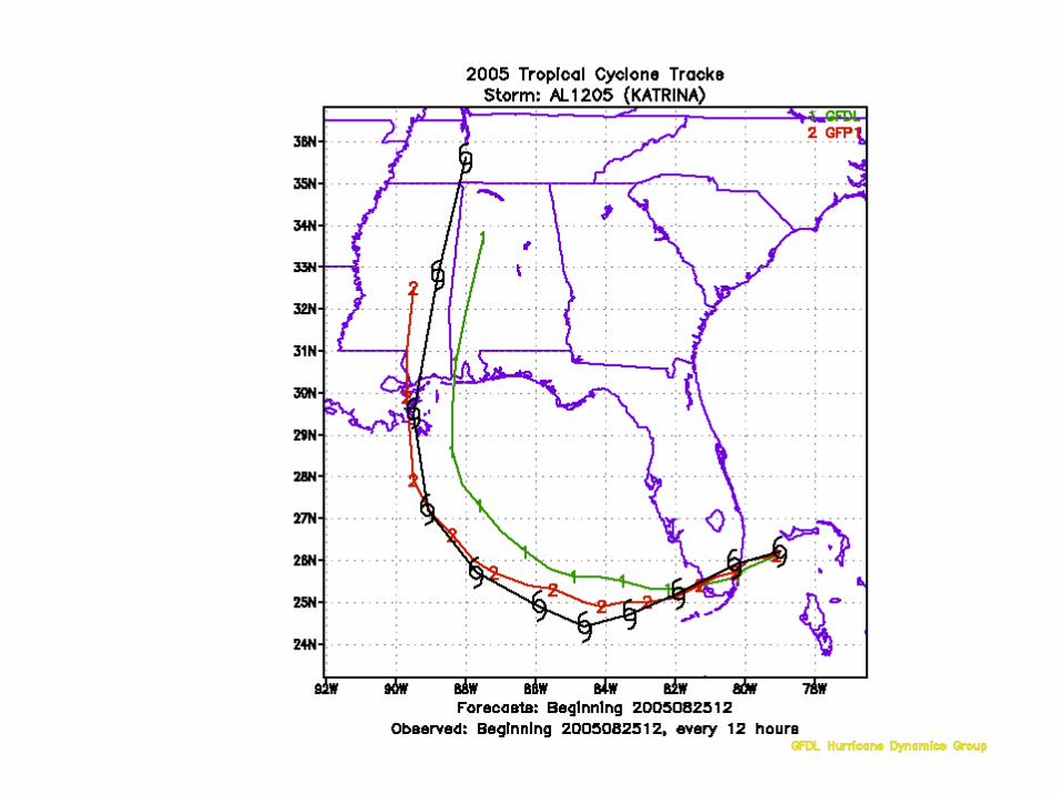
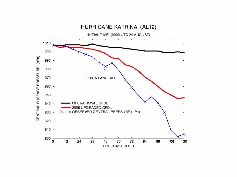
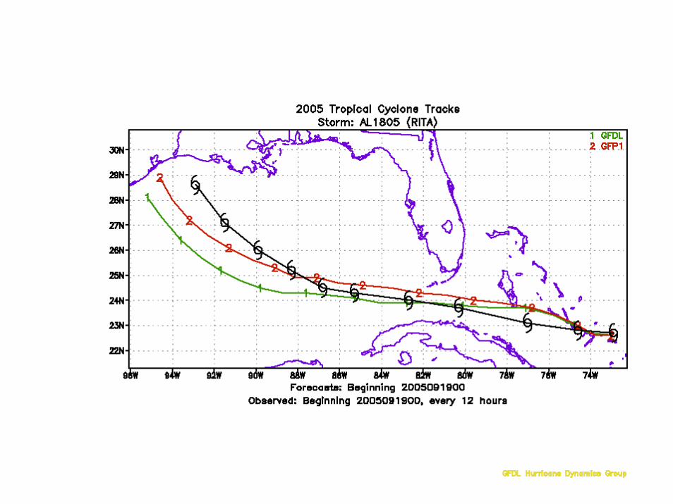
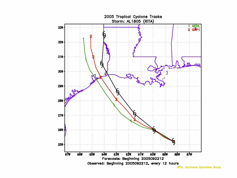
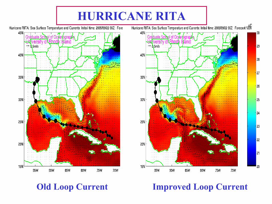
HURRICANE RITA
Improved Loop CurrentOld Loop Current
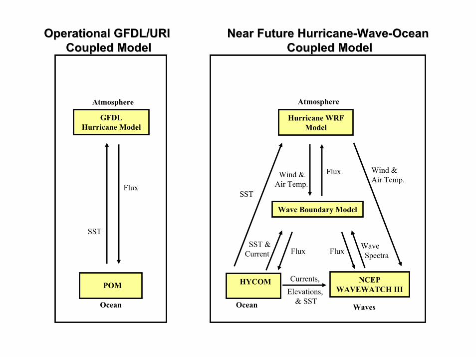
Hurricane WRFModel
NCEPWAVEWATCH III
Flux
Wind &Air Temp.
Atmosphere
Ocean Waves
Currents,
Wave Boundary Model
SST
Wave Spectra
Flux
HYCOM
Wind &Air Temp.
Flux
GFDLHurricane Model
POM
SST &Current
SST
Flux
Atmosphere
Ocean
Elevations, & SST
Operational GFDL/URI Operational GFDL/URI Coupled ModelCoupled Model
Near Future HurricaneNear Future Hurricane--WaveWave--Ocean Ocean Coupled ModelCoupled Model
Coupling of WAVEWATCH w/GFDL
Evaluation of GFDL coupled air-sea physics
Coupling is complete for GFDL air-sea-wave model (includes new air-sea momentum flux)
Evaluation still underway
Scheduled for operational implementation for ’06 season
Roughness replaced by wave-field dependent estimates of z0
Flux parameterization changed for reduced drag
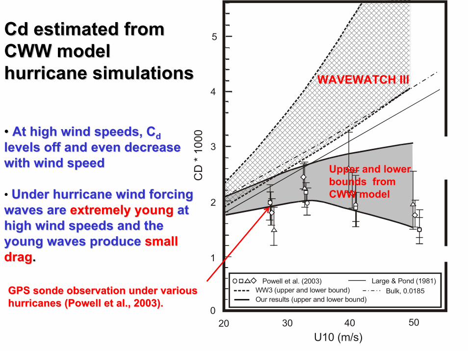
20 30 50U10 (m/s)
400
Powell et al. (2003) Large & Pond (1981)WW3 (upper and lower bound)
3
1
Our results (upper and lower bound)
5
4
2C
D *
1000
Bulk, 0.0185
•• At high wind speeds, At high wind speeds, CCddlevels off and even decrease levels off and even decrease with wind speedwith wind speed
• Under hurricane wind forcing Under hurricane wind forcing waves arewaves are extremely youngextremely young at at high wind speeds and the high wind speeds and the young waves produceyoung waves produce small small dragdrag..
Cd estimated from Cd estimated from CWW modelCWW modelhurricane simulationshurricane simulations
Upper and lower bounds from CWW model
GPS GPS sondesonde observation under various observation under various hurricanes (Powell et al., 2003). hurricanes (Powell et al., 2003).
WAVEWATCH III
880 900 920 940 960 980 1000 1020Minimum Sea Level Pressure (hPa)
10
20
30
40
50
60
70
80M
axim
um S
urfa
ce W
inds
(m/s
)
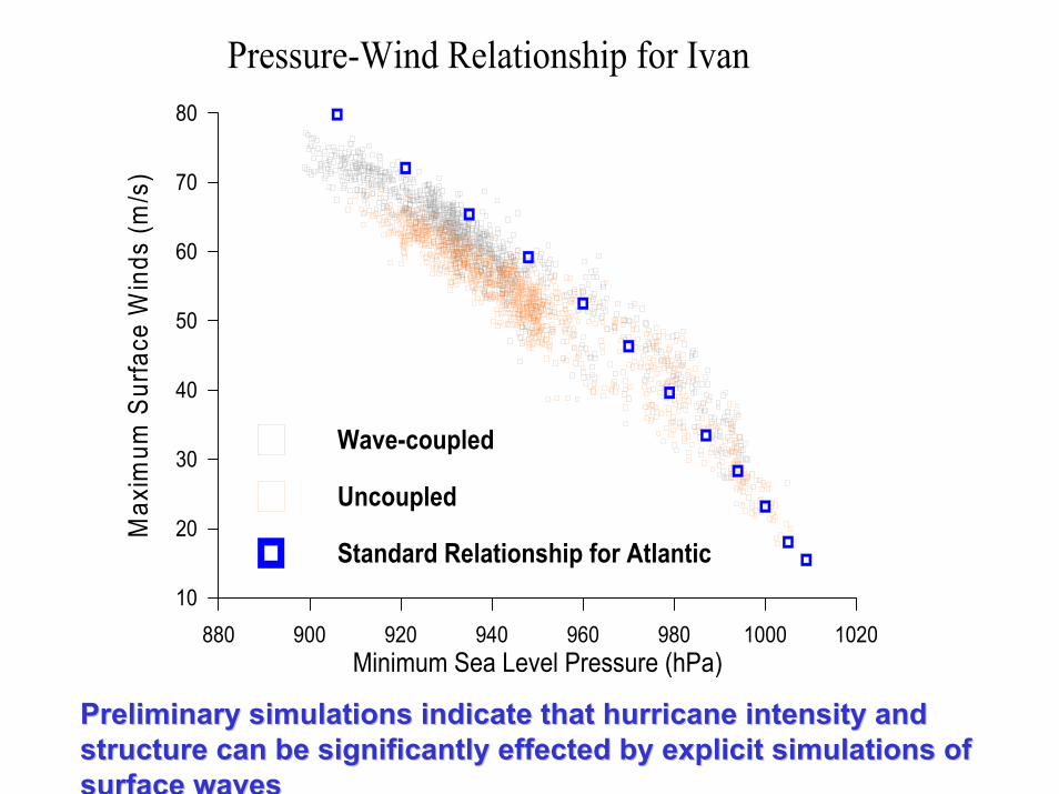
Pressure-Wind Relationship for Ivan
Wave-coupled
Uncoupled
Standard Relationship for Atlantic
Preliminary simulations indicate that hurricane intensity and Preliminary simulations indicate that hurricane intensity and structure can be significantly effected by explicit simulations structure can be significantly effected by explicit simulations of of surface wavessurface waves
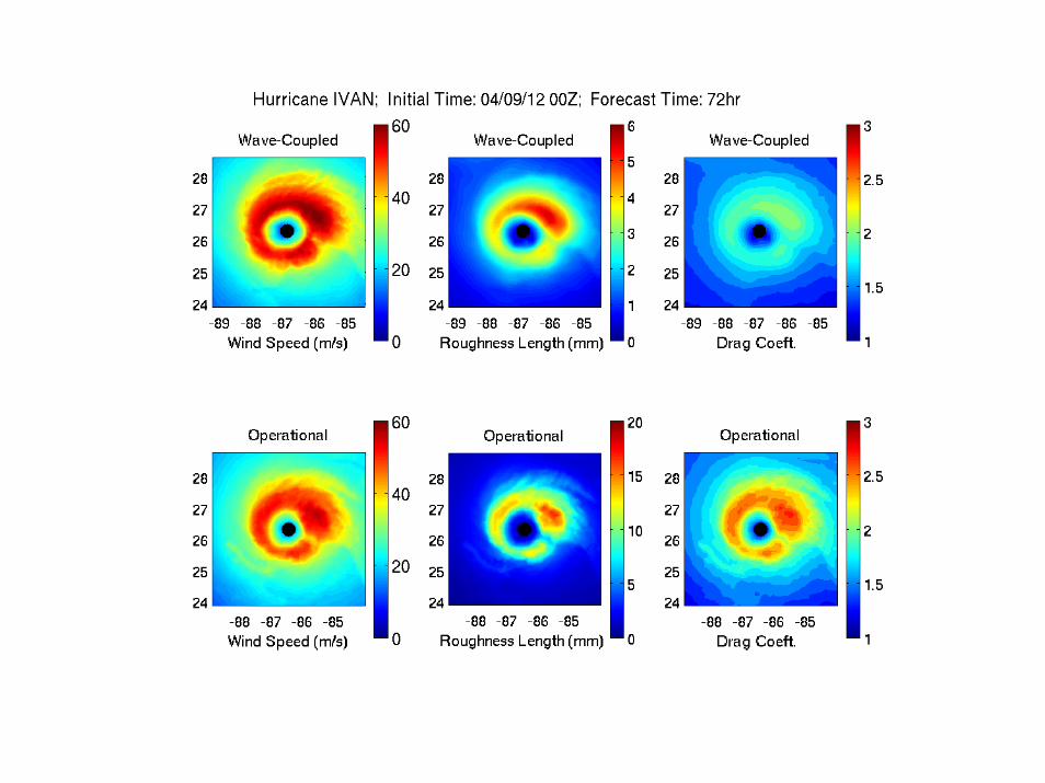
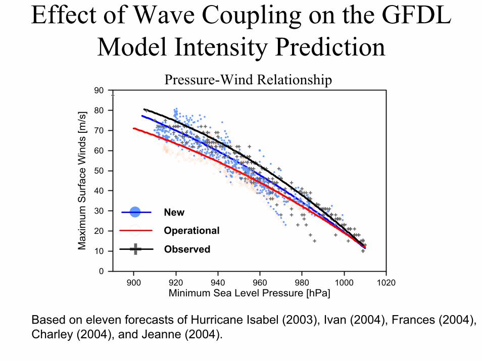
Effect of Wave Coupling on the GFDL Model Intensity Prediction
900 920 940 960 980 1000 1020Minimum Sea Level Pressure [hPa]
0
10
20
30
40
50
60
70
80
90M
axim
um S
urfa
ce W
inds
[m/s
]Pressure-Wind Relationship
New
Operational
Observed
Based on eleven forecasts of Hurricane Isabel (2003), Ivan (2004), Frances (2004), Charley (2004), and Jeanne (2004).
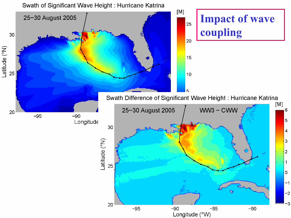
Impact of wave coupling
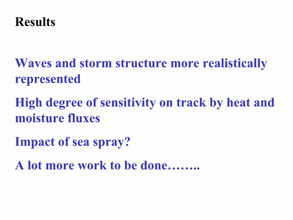
Results
Waves and storm structure more realistically represented
High degree of sensitivity on track by heat and moisture fluxes
Impact of sea spray?
A lot more work to be done……..
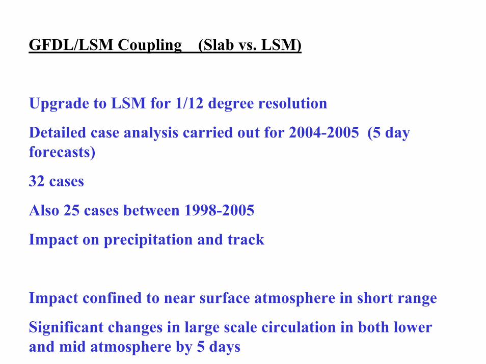
GFDL/LSM Coupling (Slab vs. LSM)
Upgrade to LSM for 1/12 degree resolution
Detailed case analysis carried out for 2004-2005 (5 day forecasts)
32 cases
Also 25 cases between 1998-2005
Impact on precipitation and track
Impact confined to near surface atmosphere in short range
Significant changes in large scale circulation in both lower and mid atmosphere by 5 days
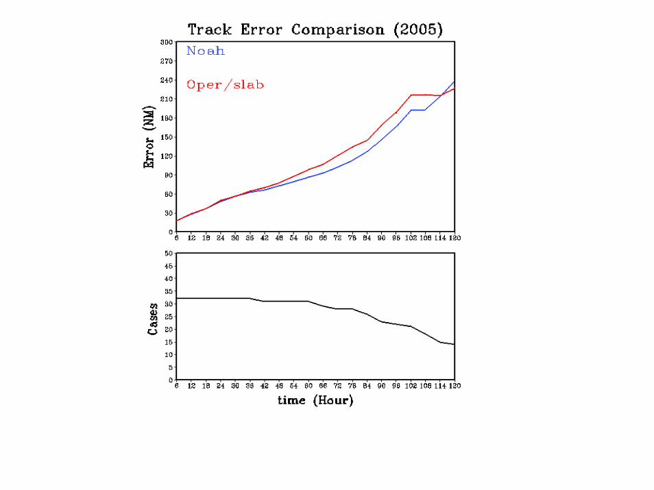
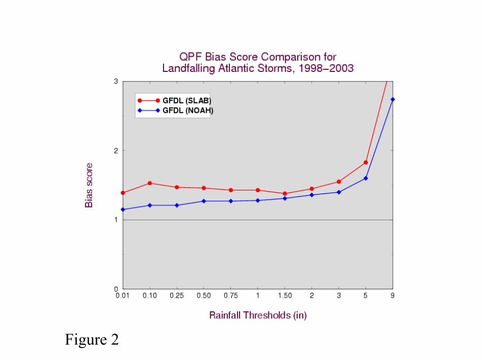
Figure 2
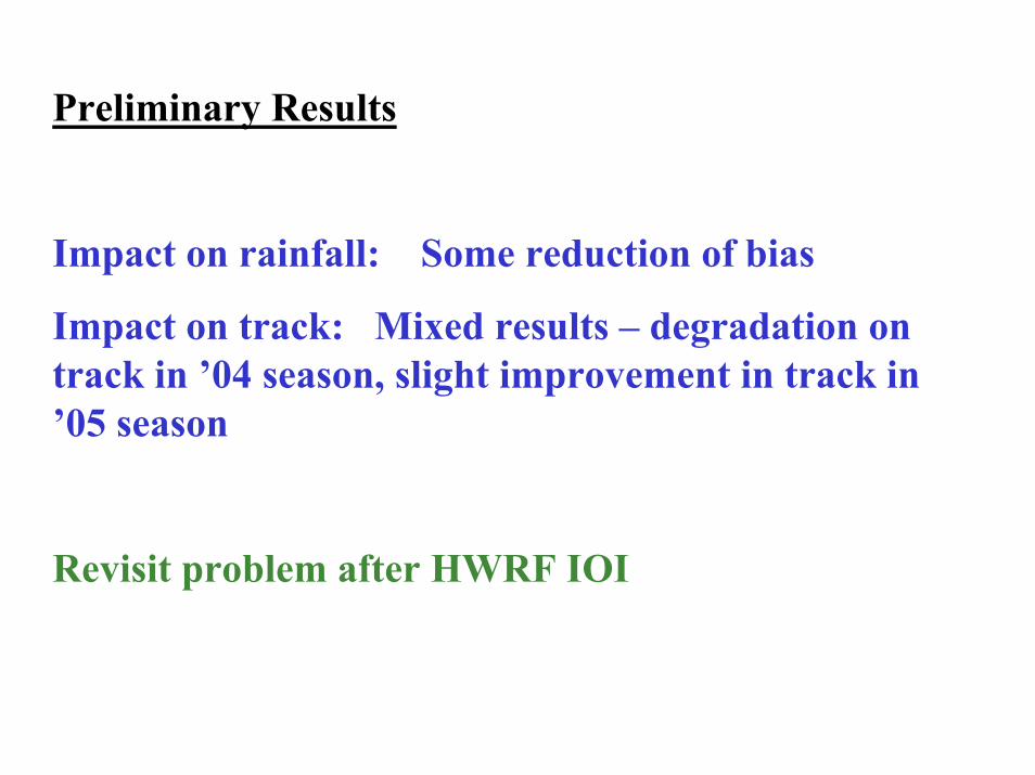
Preliminary Results
Impact on rainfall: Some reduction of bias
Impact on track: Mixed results – degradation on track in ’04 season, slight improvement in track in ’05 season
Revisit problem after HWRF IOI

TRANSITIONING TO HURRICANE WRF
02-03 03-04 05 06 07Mesoscale Data Assimilation for Hurricane Core
GFDL
MM5
Begin Physics Upgrades
Prelim. Test -grid, hurricane physics
HWRF
T&EHWRF
Operational(9km/42?L)
Final GFDL upgrades
HWRF T&E
Begin R&D
Transition to HWRF
HWRF
Continue upgrades
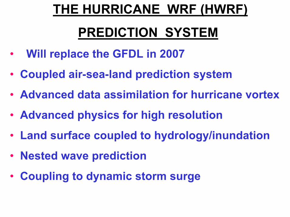
THE HURRICANE WRF (HWRF)
PREDICTION SYSTEM• Will replace the GFDL in 2007
• Coupled air-sea-land prediction system
• Advanced data assimilation for hurricane vortex
• Advanced physics for high resolution
• Land surface coupled to hydrology/inundation
• Nested wave prediction
• Coupling to dynamic storm surge
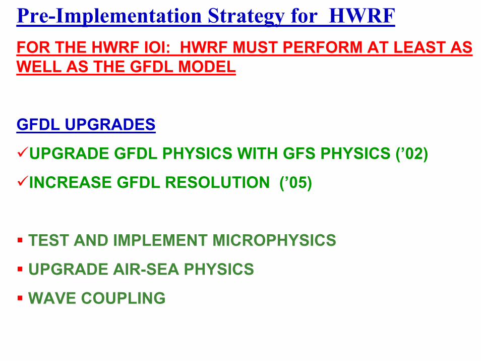
Pre-Implementation Strategy for HWRFFOR THE HWRF IOI: HWRF MUST PERFORM AT LEAST AS WELL AS THE GFDL MODEL
GFDL UPGRADES
UPGRADE GFDL PHYSICS WITH GFS PHYSICS (’02)
INCREASE GFDL RESOLUTION (’05)
TEST AND IMPLEMENT MICROPHYSICS
UPGRADE AIR-SEA PHYSICS
WAVE COUPLING
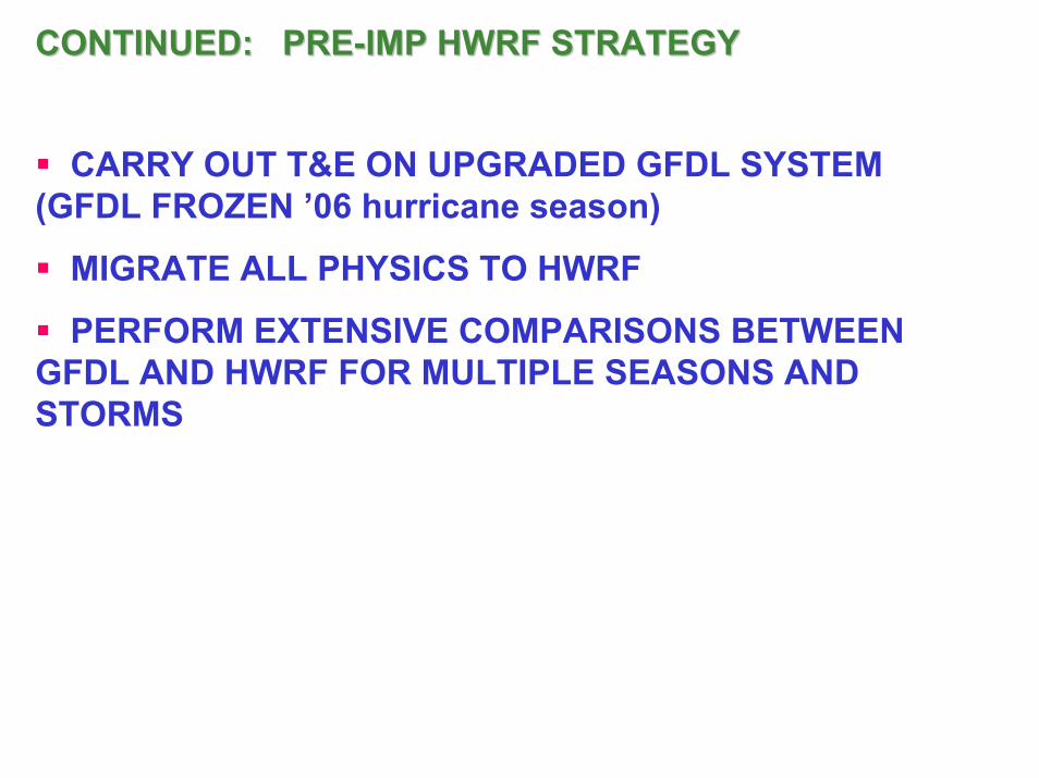
CONTINUED: PRECONTINUED: PRE--IMP HWRF STRATEGYIMP HWRF STRATEGY
CARRY OUT T&E ON UPGRADED GFDL SYSTEM (GFDL FROZEN ’06 hurricane season)
MIGRATE ALL PHYSICS TO HWRF
PERFORM EXTENSIVE COMPARISONS BETWEEN GFDL AND HWRF FOR MULTIPLE SEASONS AND STORMS
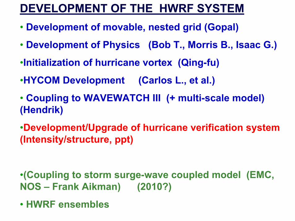
DEVELOPMENT OF THE HWRF SYSTEM• Development of movable, nested grid (Gopal)
• Development of Physics (Bob T., Morris B., Isaac G.)
•Initialization of hurricane vortex (Qing-fu)
•HYCOM Development (Carlos L., et al.)
• Coupling to WAVEWATCH III (+ multi-scale model) (Hendrik)
•Development/Upgrade of hurricane verification system (Intensity/structure, ppt)
•(Coupling to storm surge-wave coupled model (EMC, NOS – Frank Aikman) (2010?)
• HWRF ensembles
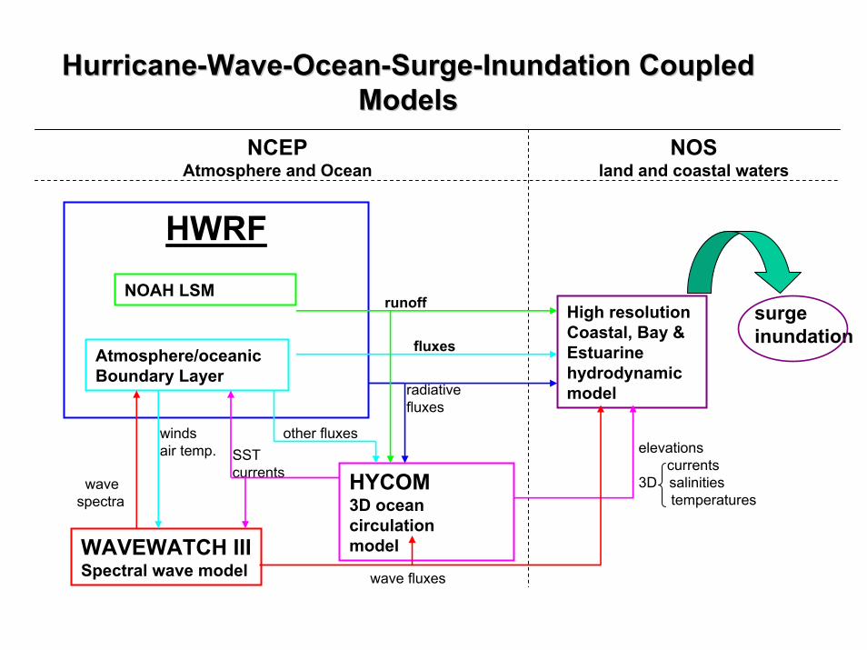
HurricaneHurricane--WaveWave--OceanOcean--SurgeSurge--Inundation Coupled Inundation Coupled ModelsModels
High resolution Coastal, Bay & Estuarine hydrodynamic model
NOSland and coastal waters
NCEPAtmosphere and Ocean
HWRFNOAH LSM
Atmosphere/oceanic Boundary Layer
HYCOM3D ocean circulationmodel
runoff
fluxes
WAVEWATCH IIISpectral wave model
windsair temp. SST
currents
elevationscurrents
3D salinitiestemperatures
other fluxes
surgeinundation
radiativefluxes
wavespectra
wave fluxes
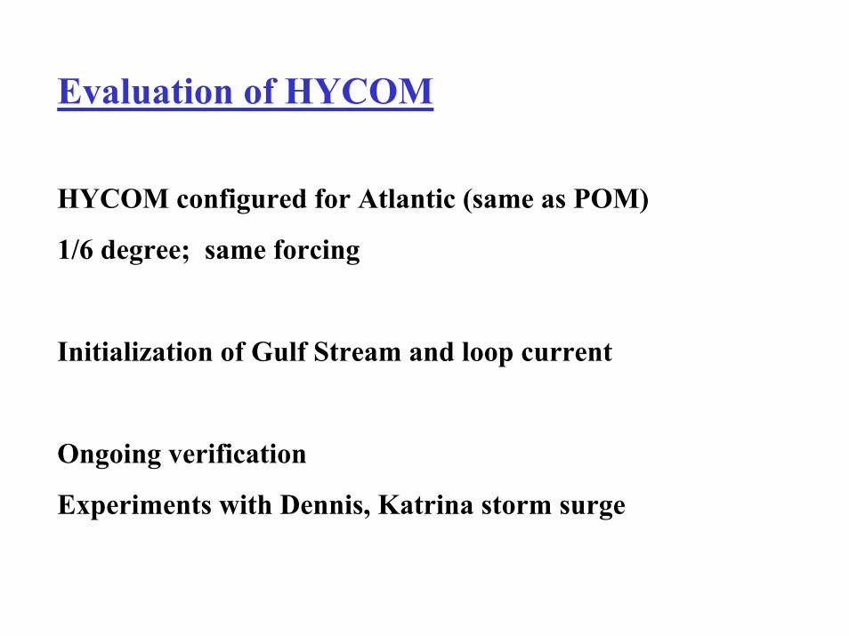
Evaluation of HYCOM
HYCOM configured for Atlantic (same as POM)
1/6 degree; same forcing
Initialization of Gulf Stream and loop current
Ongoing verification
Experiments with Dennis, Katrina storm surge
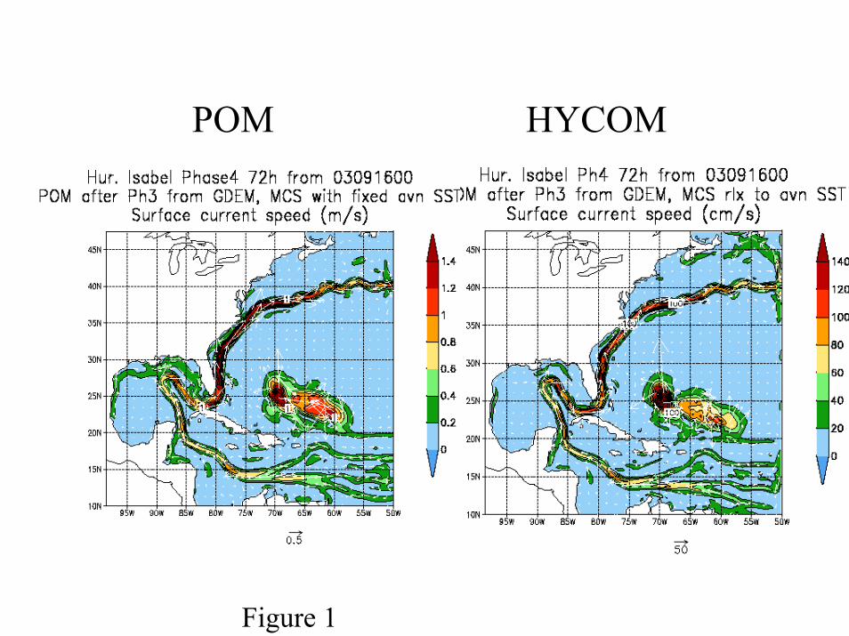
POM HYCOM
Figure 1
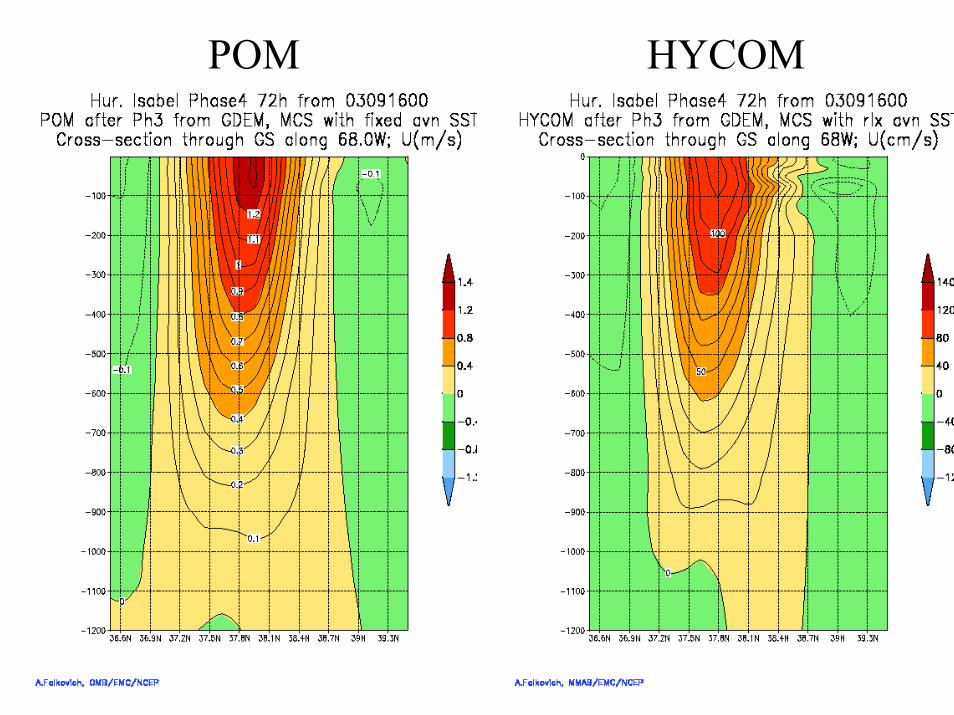
POM HYCOM
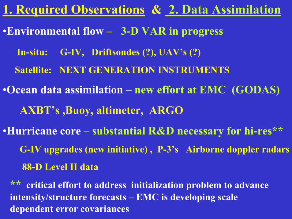
1. Required Observations & 2. Data Assimilation•Environmental flow – 3-D VAR in progress
In-situ: G-IV, Driftsondes (?), UAV’s (?)
Satellite: NEXT GENERATION INSTRUMENTS
•Ocean data assimilation – new effort at EMC (GODAS)
AXBT’s ,Buoy, altimeter, ARGO
•Hurricane core – substantial R&D necessary for hi-res**G-IV upgrades (new initiative) , P-3’s Airborne doppler radars
88-D Level II data
** critical effort to address initialization problem to advance intensity/structure forecasts – EMC is developing scale dependent error covariances
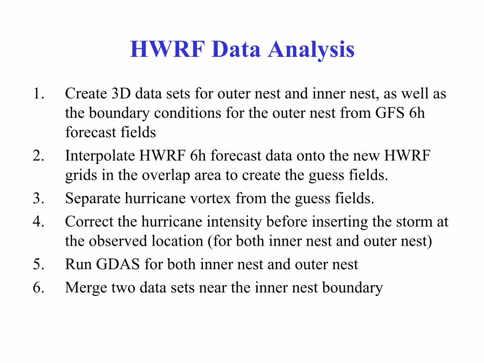
HWRF Data Analysis
1. Create 3D data sets for outer nest and inner nest, as well as the boundary conditions for the outer nest from GFS 6h forecast fields
2. Interpolate HWRF 6h forecast data onto the new HWRF grids in the overlap area to create the guess fields.
3. Separate hurricane vortex from the guess fields.4. Correct the hurricane intensity before inserting the storm at
the observed location (for both inner nest and outer nest)5. Run GDAS for both inner nest and outer nest6. Merge two data sets near the inner nest boundary
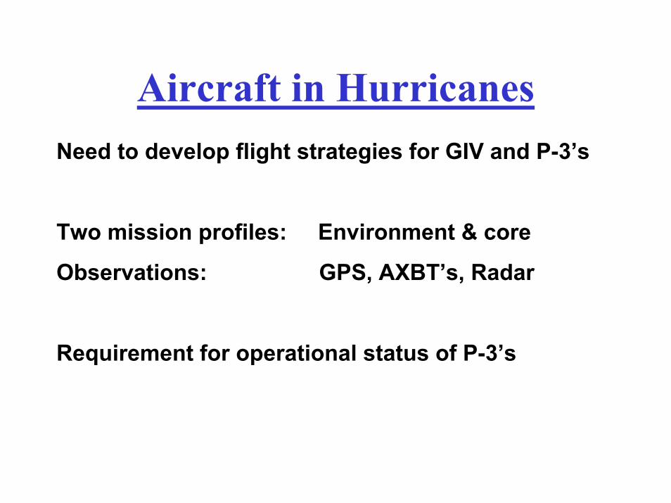
Aircraft in HurricanesNeed to develop flight strategies for GIV and P-3’s
Two mission profiles: Environment & core
Observations: GPS, AXBT’s, Radar
Requirement for operational status of P-3’s
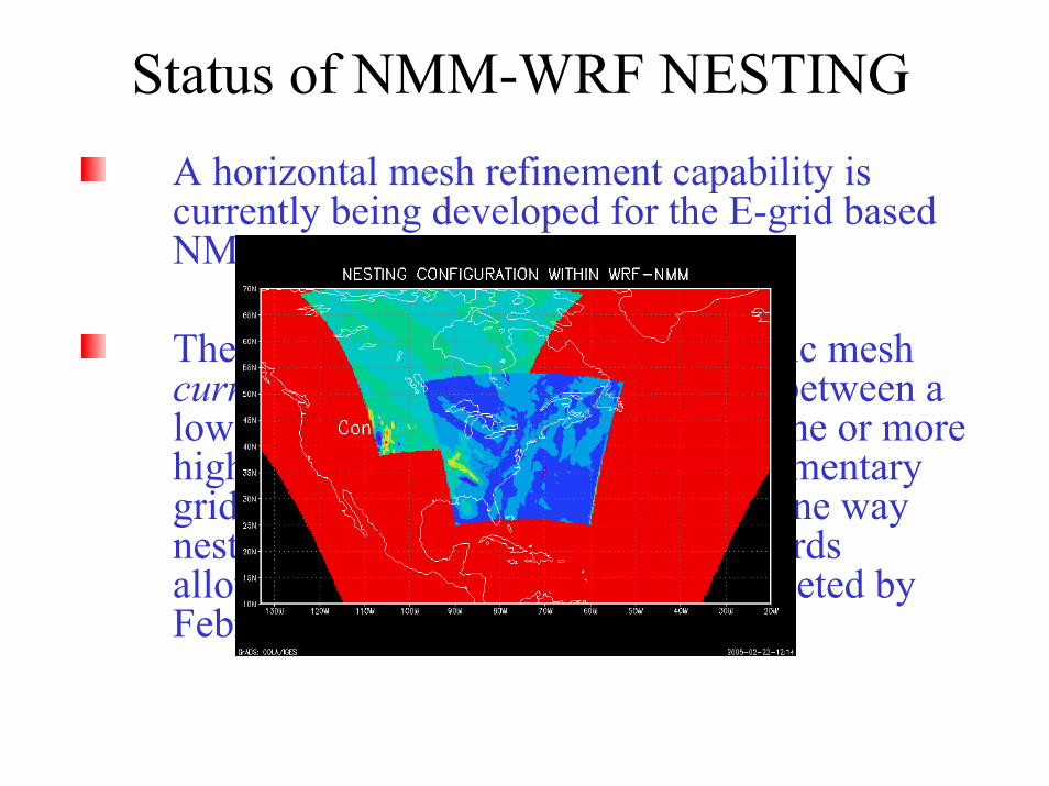
Status of NMM-WRF NESTINGA horizontal mesh refinement capability is currently being developed for the E-grid based NMM-WRF core.
The capability, referred to as telescopic mesh currently supports 1-way interaction between a lower-resolution parent domain and one or more higher-resolution nests and some rudimentary grid motion of the higher-resolution one way nest. Development is continuing towards allowing two-way interactions (completed by February 2006.
Preliminary HWRF results:
HWRF – ran 4X daily throughout ’05 hurricane season for all storms – system very stable and reliable
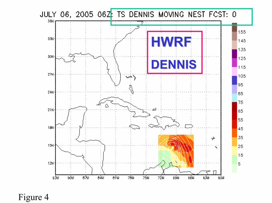
HWRFHWRFDENNISDENNIS
Figure 4
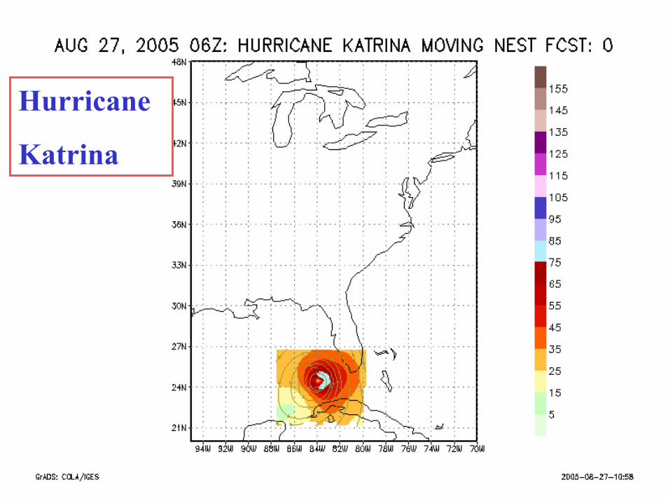
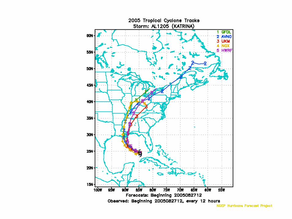
Hurricane
Katrina
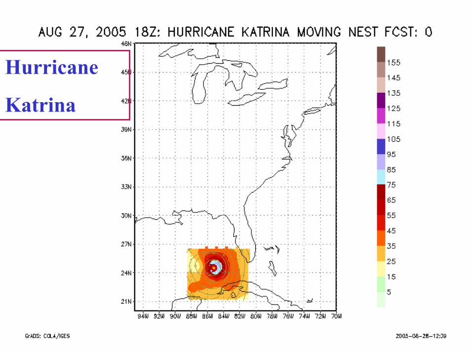
Hurricane
Katrina
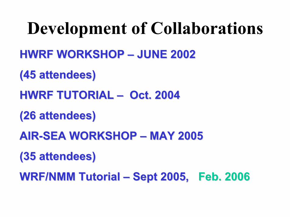
Development of CollaborationsHWRF WORKSHOP HWRF WORKSHOP –– JUNE 2002JUNE 2002
(45 attendees)(45 attendees)
HWRF TUTORIAL HWRF TUTORIAL –– Oct. 2004 Oct. 2004
(26 attendees)(26 attendees)
AIRAIR--SEA WORKSHOP SEA WORKSHOP –– MAY 2005MAY 2005
(35 attendees)(35 attendees)
WRF/NMM Tutorial WRF/NMM Tutorial –– Sept 2005, Sept 2005, Feb. 2006Feb. 2006
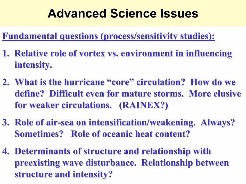
Advanced Science Issues
Fundamental questions (process/sensitivity studies):Fundamental questions (process/sensitivity studies):
1. 1. Relative role of vortex vs. environment in influencing Relative role of vortex vs. environment in influencing intensity. intensity.
2.2. What is the hurricane What is the hurricane ““corecore”” circulation? How do we circulation? How do we define? Difficult even for mature storms. More elusive define? Difficult even for mature storms. More elusive for weaker circulations. (RAINEX?)for weaker circulations. (RAINEX?)
3.3. Role of airRole of air--sea on intensification/weakening. Always? sea on intensification/weakening. Always? Sometimes? Role of oceanic heat content?Sometimes? Role of oceanic heat content?
4.4. Determinants of structure and relationship with Determinants of structure and relationship with preexisting wave disturbance. Relationship between preexisting wave disturbance. Relationship between structure and intensity? structure and intensity?
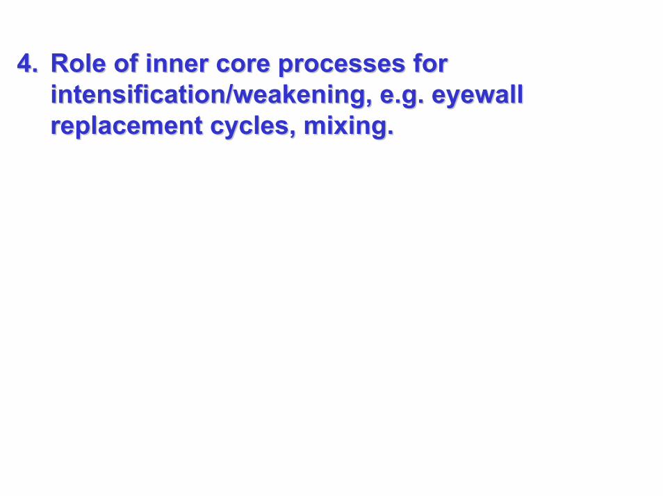
4.4. Role of inner core processes for Role of inner core processes for intensification/weakening, e.g. intensification/weakening, e.g. eyewalleyewallreplacement cycles, mixing. replacement cycles, mixing.
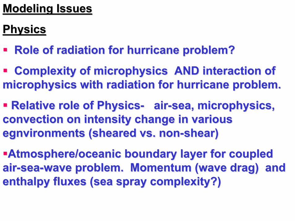
Modeling IssuesModeling Issues
PhysicsPhysics
Role of radiation for hurricane problem? Role of radiation for hurricane problem?
Complexity of microphysics AND interaction of Complexity of microphysics AND interaction of microphysics with radiation for hurricane problem.microphysics with radiation for hurricane problem.
Relative role of PhysicsRelative role of Physics-- airair--sea, microphysics, sea, microphysics, convection on intensity change in various convection on intensity change in various egnvironmentsegnvironments (sheared vs. non(sheared vs. non--shear) shear)
Atmosphere/oceanic boundary layer for coupled Atmosphere/oceanic boundary layer for coupled airair--seasea--wave problem. Momentum (wave drag) and wave problem. Momentum (wave drag) and enthalpy fluxes (sea spray complexity?) enthalpy fluxes (sea spray complexity?)
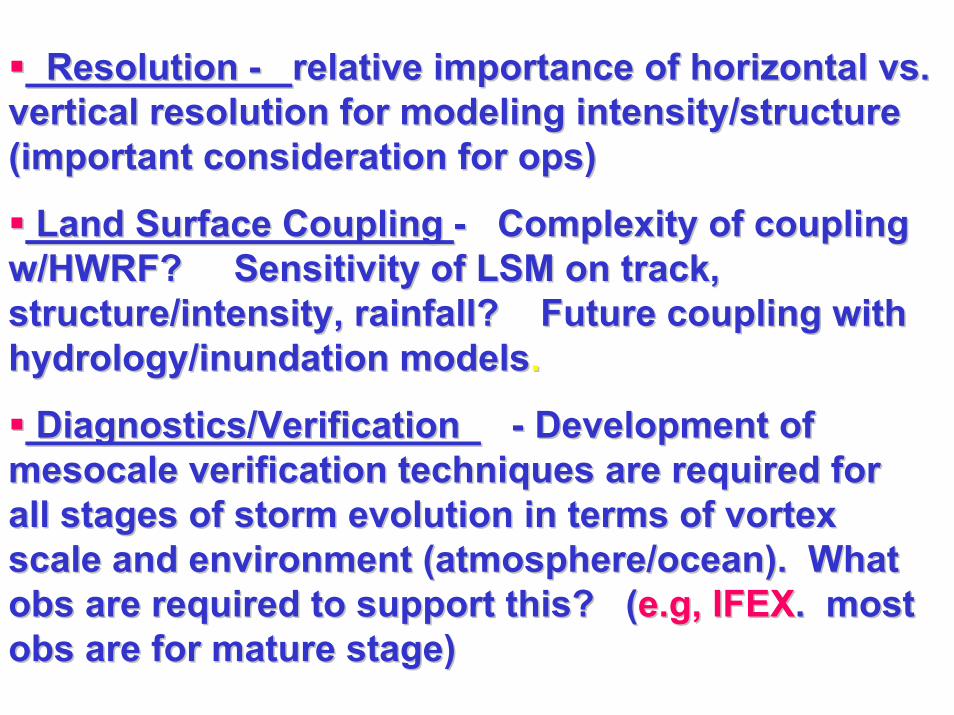
Resolution Resolution -- relative importance of horizontal vs. relative importance of horizontal vs. vertical resolution for modeling intensity/structure vertical resolution for modeling intensity/structure (important consideration for ops)(important consideration for ops)
Land Surface Coupling Land Surface Coupling -- Complexity of coupling Complexity of coupling w/HWRF? Sensitivity of LSM on track, w/HWRF? Sensitivity of LSM on track, structure/intensity, rainfall? Future coupling with structure/intensity, rainfall? Future coupling with hydrology/inundation modelshydrology/inundation models. .
Diagnostics/Verification Diagnostics/Verification -- Development of Development of mesocalemesocale verification techniques are required for verification techniques are required for all stages of storm evolution in terms of vortex all stages of storm evolution in terms of vortex scale and environment (atmosphere/ocean). What scale and environment (atmosphere/ocean). What obsobs are required to support this? (are required to support this? (e.g, IFEXe.g, IFEX. most . most obsobs are for mature stage)are for mature stage)
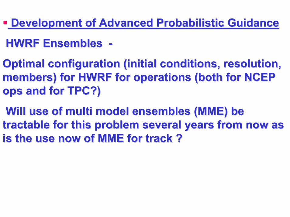
Development of Advanced Probabilistic Guidance Development of Advanced Probabilistic Guidance
HWRF Ensembles HWRF Ensembles --
Optimal configuration (initial conditions, resolution, Optimal configuration (initial conditions, resolution, members) for HWRF for operations (both for NCEP members) for HWRF for operations (both for NCEP ops and for TPC?) ops and for TPC?)
Will use of multi model ensembles (MME) be Will use of multi model ensembles (MME) be tractable for this problem several years from now as tractable for this problem several years from now as is the use now of MME for track ? is the use now of MME for track ?
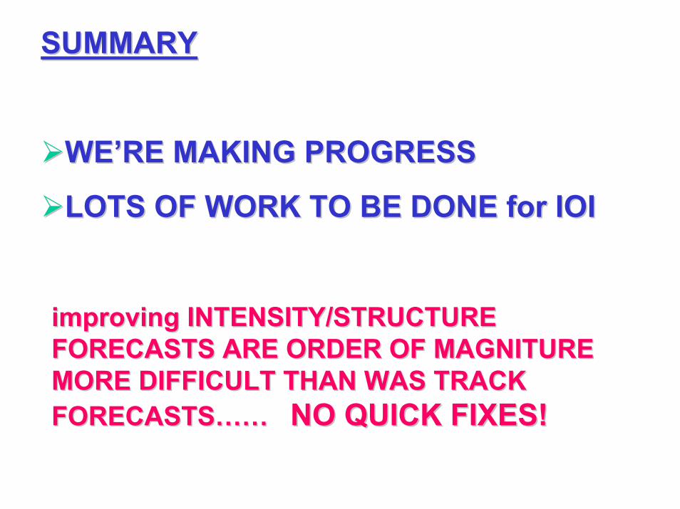
SUMMARYSUMMARY
WE’RE MAKING PROGRESSWE’RE MAKING PROGRESS
LOTS OF WORK TO BE DONE for IOILOTS OF WORK TO BE DONE for IOI
improving INTENSITY/STRUCTURE improving INTENSITY/STRUCTURE FORECASTS ARE ORDER OF MAGNITURE FORECASTS ARE ORDER OF MAGNITURE MORE DIFFICULT THAN WAS TRACK MORE DIFFICULT THAN WAS TRACK FORECASTS…… FORECASTS…… NO QUICK FIXES!NO QUICK FIXES!
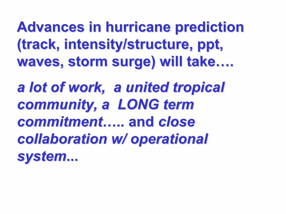
Advances in hurricane prediction Advances in hurricane prediction (track, intensity/structure, (track, intensity/structure, pptppt, , waves, storm surge) will take…. waves, storm surge) will take….
a lot of work,a lot of work, a united tropical a united tropical community, a LONG term community, a LONG term commitment…..commitment….. and and close close collaboration w/ operational collaboration w/ operational systemsystem......