Embed Size (px)
Citation preview
HUON VALLEYLAND USE AND DEVELOPMENT STRATEGY
EXECUTIVE SUMMARY

GHD | HUON VALLEY LAND USE AND DEVELOPMENT STRATEGY
EXECUTIVE SUMMARY3
BACKGROUND ................................................................................................................................................... 5
INTRODUCTION ................................................................................................................................................. 6
LAND TENURE ................................................................................................................................................... 7
KEY STRATEGIES ..............................................................................................................................................7
REGIONAL CONTEXT ......................................................................................................................................10Summary ............................................................................................................................................................................................10
THE HUON VALLEY COMMUNITY ...................................................................................................................12Summary ............................................................................................................................................................................................12
Strategic Directions & Guiding Principles ...........................................................................................................................................13
NATURAL RESOURCE MANAGEMENT ..........................................................................................................14Summary ............................................................................................................................................................................................14
Strategic Directions & Guiding Principles ...........................................................................................................................................15
Land Capability ...................................................................................................................................................................................17
Special Values.................................................................................................................................................................................... 18
NATURAL HAZARDS .........................................................................................................................................19Summary .............................................................................................................................................................................................19
Strategic Directions & Guiding Principles ...........................................................................................................................................20
Soil ....................................................................................................................................................................................................2
Bushfire ...............................................................................................................................................................................................23
Flood & Coastal Zones ...................................................................................................................................................................... 24
HERITAGE ........................................................................................................................................................ 25Summary ............................................................................................................................................................................................ 25
Strategic Directions & Guiding Principles .......................................................................................................................................... 26
TRANSPORT .................................................................................................................................................... 27Summary ............................................................................................................................................................................................ 27
Strategic Directions & Guiding Principles .......................................................................................................................................... 28
INFRASTRUCTURE ........................................................................................................................................ 29Summary ............................................................................................................................................................................................ 29
CONTENTS
Strategic Directions & Guiding Principles ................................................................................................................................................... 30
Water & Sewer Districts .............................................................................................................................................................................. 31
THE ECONOMY ....................................................................................................................................................... 32
Summary .................................................................................................................................................................................................... 32
Strategic Directions & Guiding Principles ................................................................................................................................................... 33
Spatial Analysis .......................................................................................................................................................................................... 35
SUSTAINABLE TOURISM........................................................................................................................................ 36Summary .................................................................................................................................................................................................... 36
Strategic Directions & Guiding Principles ................................................................................................................................................... 37
Spatial Analysis .......................................................................................................................................................................................... 38
PROVIDING FOR HOUSING NEEDS ...................................................................................................................... 39Summary .................................................................................................................................................................................................... 39
Strategic Directions & Guiding Principles ................................................................................................................................................... 40
Existing Settlements ................................................................................................................................................................................... 41
SETTLEMENTS ....................................................................................................................................................... 42Summary .................................................................................................................................................................................................... 42
Strategic Directions & Guiding Principles ................................................................................................................................................... 43
Overall Settlement Strategy Map................................................................................................................................................................ 48
OUTLINE DEVELOPMENT PLAN ........................................................................................................................... 49
Huonville ..................................................................................................................................................................................................... 49
Cygnet ........................................................................................................................................................................................................ 50
Franklin ....................................................................................................................................................................................................... 51
Geeveston .................................................................................................................................................................................................. 52
Dover ......................................................................................................................................................................................................... 53

HUON VALLEY LAND USE AND DEVELOPMENT STRATEGY | GHD
EXECUTIVE SUMMARY 4
The Huon Valley Land Use and Development Strategy (the Strategy) was adopted by the Huon Valley Council on the 2 October 2007 as the basis for the preparation of a single integrated planning scheme for the whole municipal area.
On the 8 November 2007 GHD Pty Ltd and Huon Valley Council also received an Award for Excellence in the Rural & Regional Planning Category from the Planning Institute of Australia Tasmania Division. The Strategy also received the Jury Chairperson’s Award for the overall winnner of the 2007 PIA Awards for Excellence
The citations for these awards are:
Rural & Regional Planning Category
The project synthesised old and new research, spanning more than a decade, to create an integrated policy framework and development strategy for the whole municipality. Innovative features include the use of Google Earth mapping and a guide to the assessment of the potential for ‘fettering’ of agricultural land by residential development. The strategy provides a sound basis for the preparation of a new planning scheme, implementation of State Policies, local settlement policies, extension of urban infrastructure and responses to climate change.
Jury Chairperson’s Award
The Land Use and Development Strategy sets a new benchmark, demonstrating that it is necessary for a Council to formulate planning policies, prepare statutory plans and support sustainable development. It provides a clear, well documented examplar of best practice for other planning authorities in Tasmania.
FOREWORD & AKNOWLEDGEMENTS
The Strategy is the result of collaboration between GHD Pty Ltd (GHD) and the Huon Valley Council, its elected members and offi cers. GHD would specifi cally like to acknowledge the efforts of Tony Ferrier in providing a wealth of information and background documentation. We also acknowledge the efforts of Bob Karaszkewych and Leigh Stevens in providing valuable feedback and direction when required as well as Holly Hansen and Aletta McDonald.
Outside of the Huon Valley Council, this document has involved input from a number of people and various organisations including Peter Fischer, Brian Risby & John Hayes from the Land Use Planning Branch, Department of Justice and Kerry Boden from the Resource Development & Planning Commission. Input has also been provided by the Department of Police and Emergency Management, Department of Economic Development and the Department of Tourism, Arts and the Environment.
Of special note is Department of Primary Industries and water for their assistance with mapping and GIS information.
Finally, GHD would like to thank the community of the Huon Valley for their valuable feedback. GHD recognises that the community offer valuable insights into the values of the Huon Valley and future directions. These insights are important to ensure that this document ultimately achieves its aim:
To provide policy direction for future land use and development of the Huon Valley that ensures sustainable economic development in the long term and the protection of the Huon Valley’s values at the same time as providing for the needs of the community today.
GHD | HUON VALLEY LAND USE AND DEVELOPMENT STRATEGY
EXECUTIVE SUMMARY5
The Huon Valley municipal area was formed during the Local Government amalgamations of the early 1990s.
Prior to this, Huon Valley was comprised of three municipalities: Esperance, Huon and Cygnet. Current strategic
land use directions and planning regulations within the municipal area have been carried over from those former
municipalities. The Planning Schemes relating to those former municipalities still remain the primary mechanism for
control over land use and development throughout the Huon Valley.
The development of a new planning scheme to cover the whole Huon Valley municipal area is seen as an imperative to ensure that current environmental, economic and social context is responded to. A new planning scheme consist of a Land Use and Development Strategy to set the strategic directions for future land use, an ordinance document to set use and development controls needed to achieve those strategic directions and a set of land use zone maps
covering the whole Huon Valley to support the operation of the ordinance document.1
GHD Pty Ltd on behalf of the Huon Valley Council has been commissioned to prepare a Land Use and Development
Strategy (the ‘Strategy’) for the Huon Valley as the fi rst step towards a new Planning Scheme. This document
provides a summarised version of the Strategy. Each section provides an overview of the relevant considerations
discussed in greater detail throughout the full document. The strategic directions and guiding principles identifi ed
have also been provided over the following key land use and development considerations:
Regional Context;
The Huon Valley Community;
Natural Resource Management;
Natural Hazards;
Heritage;
Transport;
Infrastructure;
The Economy;
Sustainable Tourism;
Providing for Housing Needs; and
Major & Minor Settlements.
1 The ordinance document component of a planning scheme is traditionally known in Tasmania as ‘the planning scheme’ and that terminology is retained in this document.
BACKGROUND

HUON VALLEY LAND USE AND DEVELOPMENT STRATEGY | GHD
EXECUTIVE SUMMARY 6
The Huon Valley area (municipal area) is second only to the West Coast Council in terms of its land coverage with a
total area of 545,973 hectares. Extending from Mount Wellington Park in the northeast the municipal area comprises
the southern part of Tasmania, encompassing large tracts of reserved areas. The municipal area is one of the few
gateways into one of Tasmania’s most signifi cant natural and recreational resources: The South-West National Park
and World Heritage Area.
Private land and development is concentrated along its eastern coast with road connections to the remainder of
Tasmania through the Kingborough municipal area which shares its eastern boundary. A strong social, environmental
and economic relationship is maintained with the Kingborough municipal area.
To the north and west of the municipal area are the Derwent Valley and West Coast municipalities. However, given the
extent of reserved areas the social and economic relationship withthese municipalities are physically constrained.
Reserved land comprises the largest land are within the municipal area with 346,126 hectares contained declared as
National Parks, State or Conservation Reserves. A further 122,512 hectares is nominated as State Forest with only
77,335 (or 14%) of the municipal area within private ownership.
INTRODUCTION

GHD | HUON VALLEY LAND USE AND DEVELOPMENT STRATEGY
EXECUTIVE SUMMARY7
LAND TENURE

HUON VALLEY LAND USE AND DEVELOPMENT STRATEGY | GHD
EXECUTIVE SUMMARY 8
The following key strategies from this Land Use & Development Strategy will be transferred to the new planning
scheme:
Community and Services Encourage the development of community facilities and services in highly accessible locations and in areas of
highest need;
Encourage the establishment of additional aged care facilities in appropriate areas close to existingphysical
and community services;
Ensure new development considers linkages between services and activities via alternative transport modes;
Require developers, where appropriate, to contribute to the provision of community services and
infrastructure;
Encourage the development of affordable housing in locations with high accessibility to town centres, community
facilities and services.
Recreation and Open Space Protect and maintain recreational amenity by ensuring surrounding development does not jeopardise the
primary recreational purpose of any area;
Identify suitable locations for the expansion of open space and recreational facilities and ensure new subdivisions
promote connectivity where needed and provide usable land for recreation.
Natural Resource Management The highest priority must be given to the protection of the natural resource base of the municipal area;
Development and use of the resource base should focus on achieving environmentally sustainable
outcomes;
All resource based use or development is to protect the quality and biodiversity of the resource base, prevent
degradation of the resource and surrounding areas, maintain and improve water quality, protect signifi cant
agricultural land, retain signifi cant stands of vegetation and protect prospective mineral and construction
materials deposits.
Environmental Protection Development and use of land and resources is to be carried out so as to minimize impacts on the natural
environment;
Land designated as National Park, Conservation Reserve, Wilderness Reserve, Nature Reserve or State
Reserve is not to be developed or used unless it can be demonstrated that the use or development can
be achieved in a manner that is consistent with the conservation of the area’s values and any approved
management plan;
Vegetation clearance is to be controlled and managed to prevent erosion, land instability, loss of water quality
and loss of scenic and visual amenity;
KEY STRATEGIES
Environmental fl ows are to be maintained in the municipal area’s major waterways;
Beaches, dunes, sand ridges, dune swales, coastal wetlands and estuaries’ cliffs subject to mass movement
are not to be used or developed in a manner that would interfere with the natural coastal processes of
erosion deposition, littoral drift and inshore current fl ows;
Buildings, structures, and works in coastal areas are not to interfere with natural processes, lead to the need
for remedial works or coastal protection measures, nor result in the removal of vegetation from potentially
mobile landforms;
Development and use in coastal areas is to be in accordance with design and siting codes designed to
protect the environmental values of the coast;
The protected environmental values which have been identifi ed for the municipal area’s waterways, estuaries
and wetlands are to be maintained in accordance with the State Policy on Water Quality Management
1997;
Heritage Use and development is to recognise the various economic benefi ts associated with managing the heritage
assets of the Huon Valley in an appropriate manner.
Identify heritage places under the Planning Scheme and provide provisions to ensure that the siting, scale,
form and appearance of development of heritage listed properties and areas does not detract from those
characteristics of the place that contribute to its cultural signifi cance.
Provide an integrated approach, involving liaison between the Aboriginal community, Council and relevant
government agencies to identify, respect and manage Aboriginal cultural heritage.
Protect the visual qualities and prevent erosion and disturbance of hill faces, ridgelines, coastal bluffs,
headlands and other prominent landforms, where it would result in a loss of landscape values
Transport and Access Include a road asset schedule with a road hierarchy to maintain the safety and effi ciency of key road
transport corridors.
Ensure new subdivisions are designed to maximise connections and promote walking and cycling.
Encourage the concentration of light industrial and commercial activities in existing towns that are accessible
to the community.
Ensure that use and development does not jeopardise future important transport corridors.
GHD | HUON VALLEY LAND USE AND DEVELOPMENT STRATEGY
EXECUTIVE SUMMARY9
Infrastructure Ensure new urban and industrial development incorporates water sensitive design, provides for protection
of water quality and incorporates landscaping that facilitates water fi ltration and removal of pollutants.
Maximise effi ciency in exisitng and future infrastructure provision by concentrating development within
the primary settlements and recognising that development outside of the areas is not entitled to serviced
land.
New development is to contribute to the cost of upgrading existing infrastructure in accordance with Council
policy to ensure that the cost is not solely borne by the community.
Existing unserviced developments should not be allowed to be more intensively occupied until such time
that it can be shown that such development will not further add to existing and emerging environmental
problems or create a demand for public infrastructure.
New development in unserviced areas should be required to demonstrate that it can meet all of its own
infrastructure requirements and that it can occur without loss of environmental quality, in particular water
quality, vegetation cover, exposure to hazard risks and landform degradation.
Encourage the innovative and sustainable forms of water use (including its reuse) for residential development
where it does not impact upon amenity.
The Economy
Ensure ongoing viability of primary industries by preventing incompatible development within identifi ed rural
areas.
Small scale non-residential activities that can occur without affecting the character or amenity of urban
residential areas should be allowed within those areas.
Resource extraction and processing activities should not be overly restricted in their form and location. The
critical outcome to be achieved in the development of processing facilities is that they meet designated
environmental standards, protect visual and scenic amenity and that they are developed and constructed to
high standards of siting and design.
Provide for the minising of external impacts while still providing for ongoing sustainable forest industry within
the municipal area.
Minimise the distance between rural industry and its associated resource base.
Sustainable Tourism Protect and enhance the Huon Trail visual landscape as an asset of the Huon Valley.
Encourage development that builds on the Huon Trail brand.
Design and siting controls should be used to reduce environmental and visual impact of new tourist
facilities.
Rural Areas Residential uses not associated with agricultural activities should occur within town boundaries.
The protection of agricultural uses from fettering by any other non-agricultural use is to be given precedence
over all other relevant planning matters.
Housing Needs and Settlements Focus residential growth within the serviced settlements of Huonville, Cygnet, Geeveston, Dover and to a lesser
extent Franklin and promote infi ll residential development to maximise the utilisation and effi ciency of existing
infrastructure and community services.
Identify areas for low-density residential or rural living development with regard to agricultural viability, existing
development patterns, environmental considerations and proximity to community services.
Ensure that new residential development conforms to a high standard of residential design in relation to privacy,
solar access and streetscape qualities.
Regional facilities should generally be located within Huonville unless the broader needs of the community are
best served by an alternate location within the Huon Valley.
The minor coastal settlements such as Southport, Verona Sands, Randalls Bay, Eggs and Bacon Bay, Garden
Island Sands, Charlotte Cove, Abels Bay, Little Roaring Beach, Roaring Beach, Rocky Bay and Surveyors Bay
will not be allowed to expand until issues of infrastructure provision and environmental management have been
resolved.
The smaller settlements of Cygnet, Franklin, Geeveston and Dover should be able to accommodate a range
of uses and forms of development provided that the physical character and amenity of these places is not
adversely affected.
KEY STRATEGIES
HUON VALLEY LAND USE AND DEVELOPMENT STRATEGY | GHD
EXECUTIVE SUMMARY 10
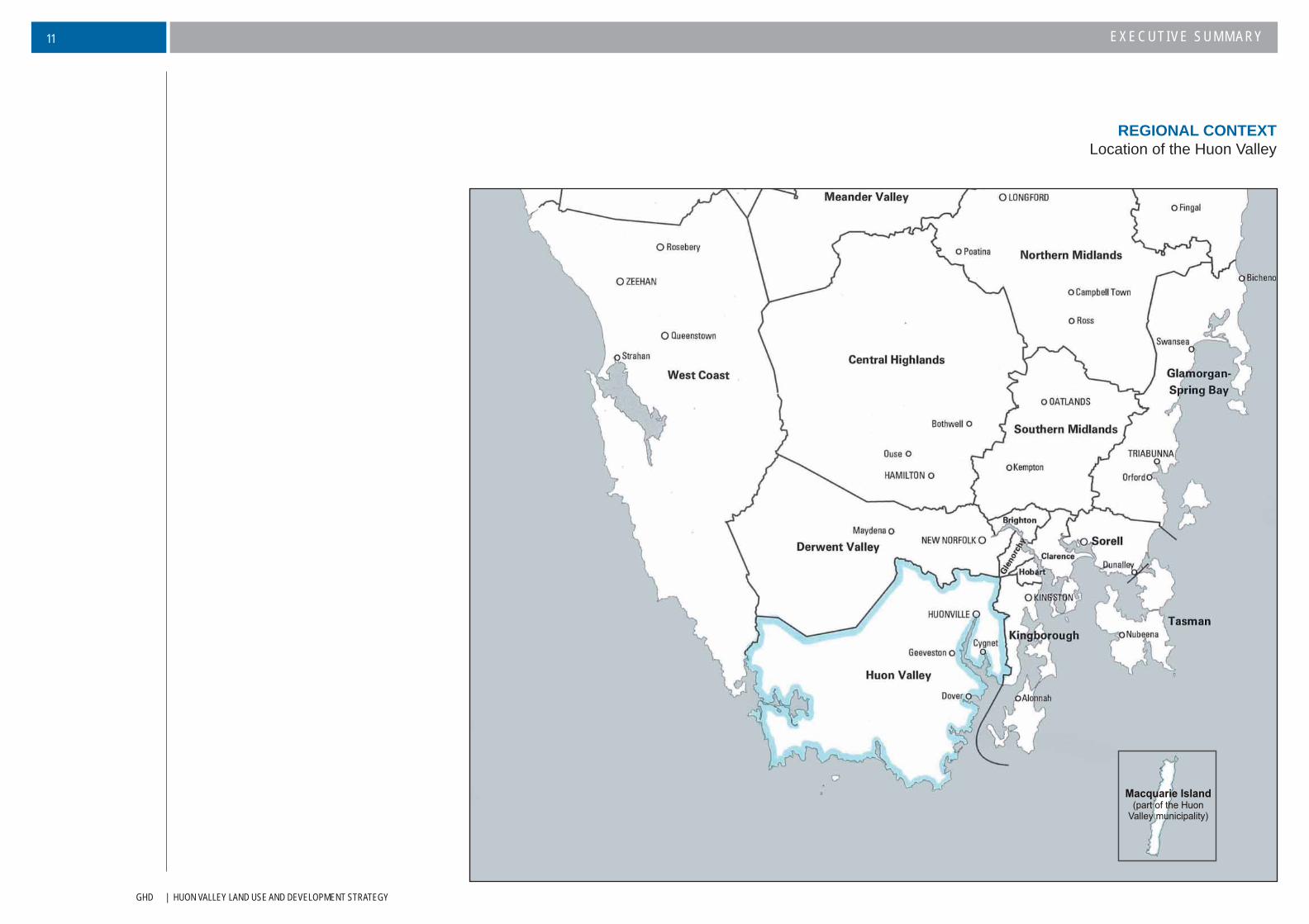
Traditionally, the Huon Valley has provided agricultural land used for the production of food, as well as timber based
industries to support Southern Tasmania. Today, due to economic factors, agricultural activity has diversifi ed away
from its near monoculture of fruit diversifying into niche markets, viticulture and aquaculture.
On a regional level, maintenance of rural lands for agriculture is seen as critically important, particularly in light of
climate change. The natural conditions and climatic regime of the municipal area offer opportunities for agricultural
activities for non-traditional farming enterprises that are otherwise constrained in many other agricultural areas of
Southern Tasmania.
The Huon Valley also plays an integral role in the tourism industry throughout Southern Tasmania. Its important
agricultural history (The Huon Valley gave Tasmania its name ‘The Apple Isle’) has been a major component in the
marketing of the area as an historical destination for tourists, but its increasing appeal as a gateway to the south-
west as well a food and wine district has also provided considerable attraction for tourism dollars.
Consideration of the relationship between Huon Valley Council and Kingborough Council is also important in developing
a successful strategic direction for Huon Valley. These two municipalities not only have a shared boundary, but Huon
Valley municipal area relies upon connections to Greater Hobart through Kingborough. Economic development is
closely linked and as evident in more recent years, the changes to the Kingborough Planning Scheme have resulted
in increasing pressure within the municipal area to meet the demand for rural residential lots.
With Huonville located only 39 kilometres and 30 minutes drive by major highway from the Hobart CBD it is inevitable
much recent development has been fuelled by people attracted by the rural lifestyle, its scenic beauty, affordable
housing and relatively cheap land. Decisions have also been infl uenced by the range of facilities available within the
Huon Valley’s major settlements, and its proximity to regional shopping facilities at Kingston.
Many of these new residents also bring new skills and capital to the area and this has fuelled a number of new
business enterprises particularly in the retailing, tourism and agricultural sectors. However, growth needs to be
managed to be within Council’s capacity to provide or fund infrastructure, and to ensure protection of the municipal
area’s natural and cultural values.
REGIONAL CONTEXTSummary
GHD | HUON VALLEY LAND USE AND DEVELOPMENT STRATEGY
EXECUTIVE SUMMARY11
REGIONAL CONTEXTLocation of the Huon Valley
HUON VALLEY LAND USE AND DEVELOPMENT STRATEGY | GHD
EXECUTIVE SUMMARY 12
The Huon Valley has a population of just over 14,000 people with a small but steady growth rate of 0.5-1.0%. Huon Valley has also followed the Tasmanian trend of an increase in median age. Research for the period of 2004-2021 indicates that there will be a high increase in people in older age groups while there will be a decrease in younger age groups.
The Huon Valley community is characterised by diversity. A number of small different communities are present across the municipal area. This can be partially contributed to the settlement pattern and the distribution of population across towns with very different historical evolutions. There are also large numbers of residents from families with multi-generational ties to their communities.
The nature of the communities can also manifest itself in the built characteristics of a town. Cygnet’s and Franklin’s visual characteristics are consistent with a more ‘arts and cultural’ image while Geeveston and Dover communities have focused on traditional forestry and fi shing industries. The growing areas of rural residential development is also a physical manifestation of increasing commuter population.
Understanding the social and community profi les of the population within Huon Valley is important so that Council can plan to create and maintain liveable and healthy communities.
The increasing number of older people within the Huon Valley community will place greater pressure for additional development of aged care facilities and for housing models that are more suited to less mobile members of community in close proximity to services and facilities. It will also be important that the Strategy encourages alternative accommodation options for older persons.
Retaining young people within the Huon Valley is also essential for sustainable economic and social development as well as assisting in the social diversity of communities. Community needs for young people focus around the need for informal recreational spaces and fl exibility in housing, particularly in regards to the current demands for low cost housing.
Another consideration for the community is safety. The role of the built environment in crime prevention is a relatively new concept. The Strategy recognises the ‘Crime Prevention through Environment Design’ principles (CPTED) and encourages the implementation of these through new development. By doing so, this creates a more attractive and liveable built environment which in turn facilitate increased economic activity.
Key social and community factors in this land use and development strategy are focussed around development strategies for the:
Needs of differing and diverse individual communities;
Planning for a diversity of age in terms of accommodation and service provision;
Addressing the affordable housing requirements of the community;
Providing for community facilities that are accessible for all; and
Providing for recreational and open space opportunities for people with all differing levels
of mobility.
THE HUON VALLEY COMMUNITYSummary
GHD | HUON VALLEY LAND USE AND DEVELOPMENT STRATEGY
EXECUTIVE SUMMARY13
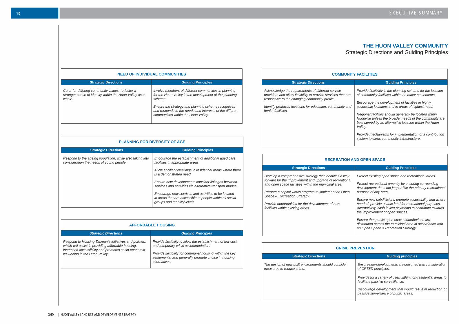
THE HUON VALLEY COMMUNITYStrategic Directions and Guiding Principles
NEED OF INDIVIDUAL COMMUNITIES
Strategic Directions Guiding Principles
Cater for differing community values, to foster a stronger sense of identity within the Huon Valley as a whole.
Involve members of different communities in planning for the Huon Valley in the development of the planning scheme.
Ensure the strategy and planning scheme recognises and responds to the needs and interests of the different communities within the Huon Valley.
PLANNING FOR DIVERSITY OF AGE
Strategic Directions Guiding Principles
Respond to the ageing population, while also taking into consideration the needs of young people.
Encourage the establishment of additional aged care facilities in appropriate areas.
Allow ancillary dwellings in residential areas where there is a demonstrated need.
Ensure new developments consider linkages between services and activities via alternative transport modes.
Encourage new services and activities to be located in areas that are accessible to people within all social groups and mobility levels.
AFFORDABLE HOUSING
Strategic Directions Guiding Principles
Respond to Housing Tasmania initiatives and policies, which will assist in providing affordable housing, increased accessibility and promotes socio-economic well-being in the Huon Valley.
Provide fl exibility to allow the establishment of low cost and temporary crisis accommodation.
Provide fl exibility for communal housing within the key settlements, and generally promote choice in housing alternatives.
RECREATION AND OPEN SPACE
Strategic Directions Guiding Principles
Develop a comprehensive strategy that identifi es a way forward for the improvement and upgrade of recreational and open space facilities within the municipal area.
Prepare a capital works program to implement an Open Space & Recreation Strategy.
Provide opportunities for the development of new facilities within existing areas.
Protect existing open space and recreational areas.
Protect recreational amenity by ensuring surrounding development does not jeopardise the primary recreational purpose of any area.
Ensure new subdivisions promote accessibility and where needed, provide usable land for recreational purposes. Alternatively, cash in lieu payments to contribute towards the improvement of open spaces.
Ensure that public open space contributions are distributed across the municipal area in accordance with an Open Space & Recreation Strategy
COMMUNITY FACILITIES
Strategic Directions Guiding Principles
Acknowledge the requirements of different service providers and allow fl exibility to provide services that are responsive to the changing community profi le.
Identify preferred locations for education, community and health facilities.
Provide fl exibility in the planning scheme for the location of community facilities within the major settlements.
Encourage the development of facilities in highly accessible locations and in areas of highest need.
Regional facilities should generally be located within Huonville unless the broader needs of the community are best served by an alternative location within the Huon Valley.
Provide mechanisms for implementation of a contribution system towards community infrastructure.
CRIME PREVENTION
Strategic Directions Guiding principles
The design of new built environments should consider measures to reduce crime.
Ensure new developments are deisgned with consdieration of CPTED principles.
Provide for a variety of uses within non-residential areas to facilitate passive survelillance.
Discourage development that would result in reduction of passive surveillance of public areas.
HUON VALLEY LAND USE AND DEVELOPMENT STRATEGY | GHD
EXECUTIVE SUMMARY 14
The municipal area is a region of immense cultural and natural diversity. Along the eastern and northeastern areas,
settlements are nestled among the rolling hills of the eastern valleys and the spectacular coastline and waterways of
the Huon Estuary and D’Entrecasteaux Channel. These in turn are set against a backdrop of extensive native forest
areas and striking mountain ranges, beyond which lies the Tasmanian Wilderness World Heritage Area (WHA),
tantalising and mysterious in its relative inaccessibility.
These natural resources not only have inherent value but are important community assets that warrant protection.
Maintaining the quality of the municipal area’s natural resources is an essential requirement if the social, cultural and
economic welfare of the population is to be maintained over the longer term.
The signifi cant natural features within the Huon Valley include:
A maritime climate, with temperature and rainfall gradients across the region from west to east. Zonal
westerly winds produce predominantly changeable, cool temperate conditions.
Geodiversity of local, national and international signifi cance.
A relatively pristine water catchment originating deep in the WHA.
In contrast a highly utilised wetland, waterway and groundwater resource within the settled areas of
the Huon Valley, creating water quality issues.
A coastal environment upon which settlement and development has been focused creating a risk to
human settlement from climate change. The coastline environment also has a high concentration of
sites of cultural, Aboriginal and natural signifi cance.
An extensive array of natural fl ora and fauna resources that are signifi cant at a regional, State and in
some instances national level. While many of these fl ora and fauna values are protected within the
reserved areas (National Parks/WHA) the interface between the urban/agricultural areas provides
signifi cant concern.
The planning scheme will represent the culmination of an appropriate mix of local, regional and State-based strategic
directions. It will be the working document that can put into effect the objectives developed within these various
approved strategies and policies. Within the municipal area, there is Council’s Strategic Plan and the Draft Natural
Resource Management Strategy. The latter strategy interprets the current environmental, social and economic
situation in order to appropriately inform the proposed new planning scheme. At a State level, the RMPS provides
the overall framework, within which sit such various initiatives as State of the Environment reports, Natural Resource
Management, environment and planning legislation, and State Policies. The table on the next page highlights the
various inter-relationships
NATURAL RESOURCE MANAGEMENTSummary
HUON VALLEY PLANNING SCHEME
THE RESOURCE MANAGEMENT & PLANNING SYSTEM OF TASMANIA (RMPS)
STATE OF THE ENVIRONMENT
REPORTREGIONAL NRM STATE POLICIES
LAND USE PLANNING &
APPROVALS ACT 1993
HUON NRM
HUON VALLEY LAND USE & DEVELOPMENT STRATEGY
HUON VALLEY STRATEGIC PLAN

GHD | HUON VALLEY LAND USE AND DEVELOPMENT STRATEGY
EXECUTIVE SUMMARY15
PROMOTION OF NATURAL RESOURCE MANAGEMENT
Strategic Directions Guiding Principles
Integrate principles of Natural Resource Management with land use and development controls.
Recognise the importance of maintaining natural values through natural resource management.
Ensure the planning scheme promotes an integration of management methods within State and regional NRM frameworks.
Ensure the planning scheme incorporates Council adopted natural resource management strategies.
Ensure the planning scheme is consistent with NRM related legislation and policies.
Ensure the planning scheme allows for community NRM initiatives.
NATURAL RESOURCE MANAGEMENTStrategic Directions and Guiding Principles
PROTECTION OF WATERWAYS AND WETLANDS
Strategic Directions Guiding Principles
Recognise the importance of the protection of wetlands and waterways within the Huon Valley.
Require development to maintain the identifi ed Protected Environmental Values (PEV’s), as documented in the State Policy on Water Quality Management (1997). This will ensure that diffuse source and point source pollution does not prejudice the achievements of Water Quality Objectives, and that pollutants discharged into waterways are reduced as far as possible by the use of best practice environmental management.
Maintain environment fl ows in all major waterways to protect natural ecological processes and water quality.
Maintain and enhance the quality of riparian and fringe vegetation alongside waterways.
Water extraction development (water storages, access to groundwater and riparian users) is to be assessed for potential environmental impacts and appropriately mananged.
Encourage restricted stock access to prevent stream bank erosion.
Minimise in-stream works and activities.
Prevent development within wetlands unless unavoidable in achieving a wider environmental and social community benefi t.
New development should comply with the recognised management manuals and guidelines including the Waterways and Wetlands Manual, FPA riparian requirements and stormwater management guidelines.
Use and development should avoid:
Visual and ecological disturbance.
Confl ict with recreational & tourism values on the foreshore.
Changes to the natural movement of river fl ows.
The spread of weeds, pests and diseases.
In stream barriers to fi sh passage.
LAND SYSTEMS
Strategic Directions Guiding Principles
Recognise the importance of land systems in the Huon Valley and provide appropriate mechanism for their protection
Utilise relevant land system information and mapping to determine further development requirements for investigating and assessing the management of soil-related hazards.
Ensure that the planning scheme protects areas with recognised geoheritage value.
HUON VALLEY LAND USE AND DEVELOPMENT STRATEGY | GHD
EXECUTIVE SUMMARY 16
NATURAL RESOURCE MANAGEMENTStrategic Directions and Guiding Principles
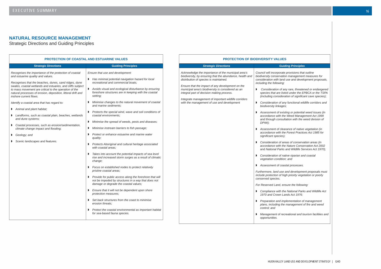
PROTECTION OF COASTAL AND ESTUARINE VALUES
Strategic Directions Guiding Principles
Recognises the importance of the protection of coastal and estuarine quality and values.
Recognises that the beaches, dunes, sand ridges, dune swales, coastal wetlands and estuaries, and cliffs subject to mass movement are critical to the operation of the natural processes of erosion, deposition, littoral drift and inshore current fl ows.
Identify a coastal area that has regard to:
Animal and plant habitat;
Landforms, such as coastal plain, beaches, wetlands and dune systems;
Coastal processes, such as erosion/sedimentation, climate change impact and fl ooding;
Geology; and
Scenic landscapes and features.
Ensure that use and development:
Has minimal potential navigation hazard for local recreational and commercial boats;
Avoids visual and ecological disturbance by ensuring foreshore structures are in keeping with the coastal setting;
Minimise changes to the natural movement of coastal and marine sediments;
Protects the special wind, wave and soil conditions of coastal environments;
Minimise the spread of weeds, pests and diseases;
Minimise instream barriers to fi sh passage;
Protect or enhance estuarine and marine water quality;
Protects Aboriginal and cultural heritage associated with coastal areas;
Takes into account the potential impacts of sea level rise and increased storm surges as a result of climatic change;
Focus on established nodes to protect relatively pristine coastal areas;
Provide for public access along the foreshore that will not be impeded by structures in a way that does not damage or degrade the coastal values;
Ensure that it will not be dependent upon shore protection measures;
Set back structures from the coast to minimise erosion threats;
Protect the coastal environmental as important habitat for sea-based fauna species.
PROTECTION OF BIODIVERSITY VALUES
Strategic Directions Guiding Principles
Acknowledge the importance of the municipal area’s biodiversity, by ensuring that the abundance, health and distribution of species is maintained.
Ensure that the impact of any development on the municipal area’s biodiversity is considered as an integral part of decision making process.
Integrate management of important wildlife corridors with the management of use and development
Council will incorporate provisions that outline biodiversity conservation management measures for consideration with land use and development proposals, including the following:
Consideration of any rare, threatened or endangered species that are listed under the EPBCA or the TSPA (including consideration of signifi cant cave species);
Consideration of any functional wildlife corridors and biodiversity linkages;
Assessment of existing or potential weed issues (in accordance with the Weed Management Act 1999 and through consultation with the weed division of DPIW);
Assessment of clearance of native vegetation (in accordance with the Forest Practices Act 1985 for signifi cant species);
Consideration of areas of conservation areas (in accordance with the Nature Conservation Act 2002 and National Parks and Wildlife Services Act 1970);
Consideration of native riparian and coastal vegetation condition; and
Assessment of coastal processes.
Furthermore, land use and development proposals must include protection of high priority vegetation or poorly conserved species.
For Reserved Land, ensure the following:
Compliance with the National Parks and Wildlife Act 1970 and Crown Lands Act 1976;
Preparation and implementation of management plans, including the management of fi re and weed control; and
Management of recreational and tourism facilities and opportunities.
GHD | HUON VALLEY LAND USE AND DEVELOPMENT STRATEGY
EXECUTIVE SUMMARY17
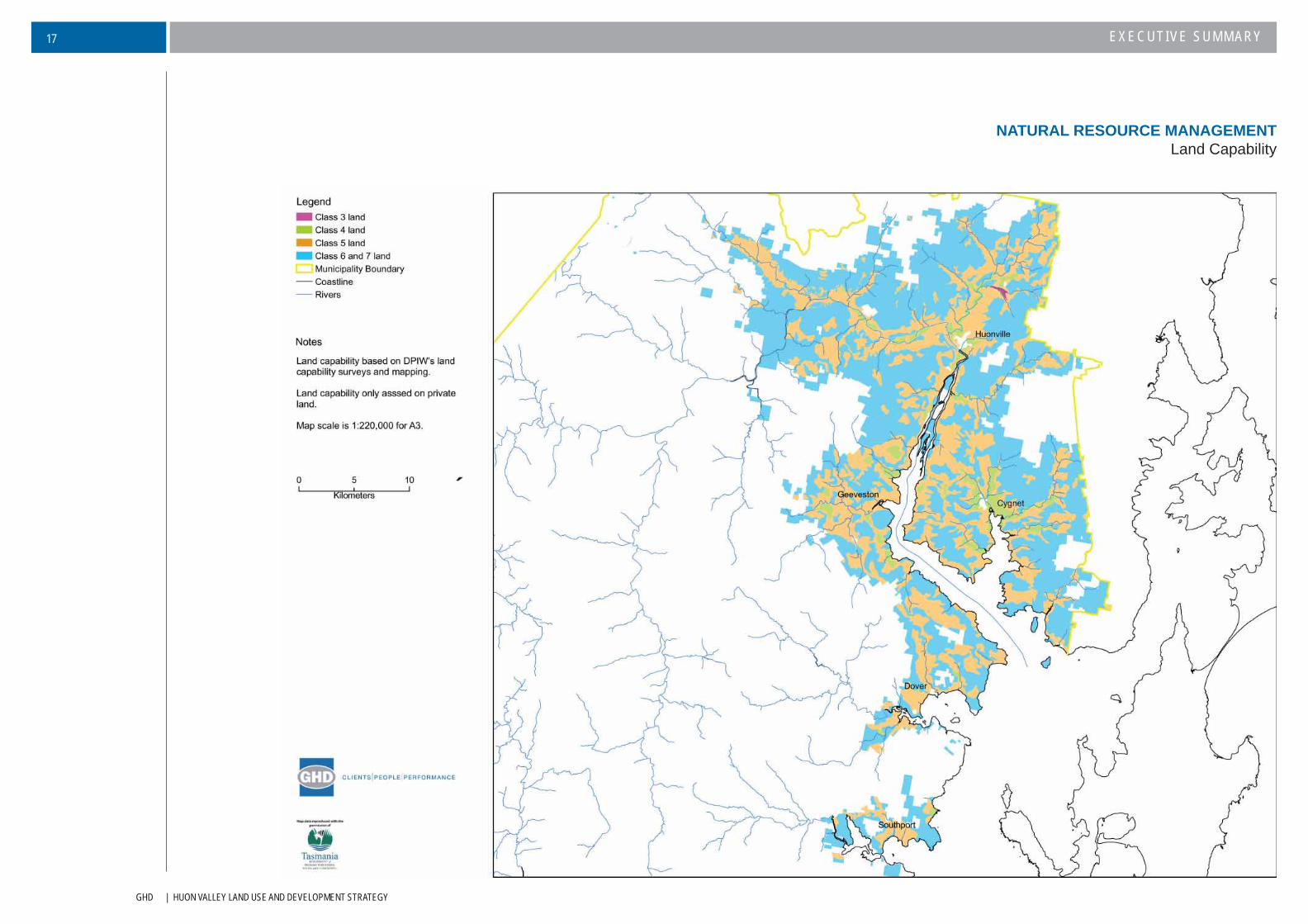
NATURAL RESOURCE MANAGEMENTLand Capability

HUON VALLEY LAND USE AND DEVELOPMENT STRATEGY | GHD
EXECUTIVE SUMMARY 18
NATURAL RESOURCE MANAGEMENTSpecial Values
GHD | HUON VALLEY LAND USE AND DEVELOPMENT STRATEGY
EXECUTIVE SUMMARY19
Natural hazards pose varying degrees of risk to human safety and property throughout the municipal area, with bushfi re events posing a particular risk to human life. The use of non-urban land for residential development has signifi cantly increased the level of risk from natural hazards. The large number of small vacant lots in areas prone to natural hazard, combined with the ongoing demand for rural residential opportunities suggest that the degree of risk from natural hazards has the potential to increase over time.
The main soil-related hazards include landslip and tunnel erosion. The municipal area has extensive areas of steeply sloping land that is potentially susceptible to landslip. Factors that may promote landslip occurrence including vegetation clearance, alteration of drainage conditions, excavation and excessive loading from structures. Tunnel erosion on the other hand is a more insidious form of risk, resulting in considerable damage even before surface manifestations are evident. The cost of tunnel erosion not only relates to loss of soils, but can affect the structural integrity of buildings.
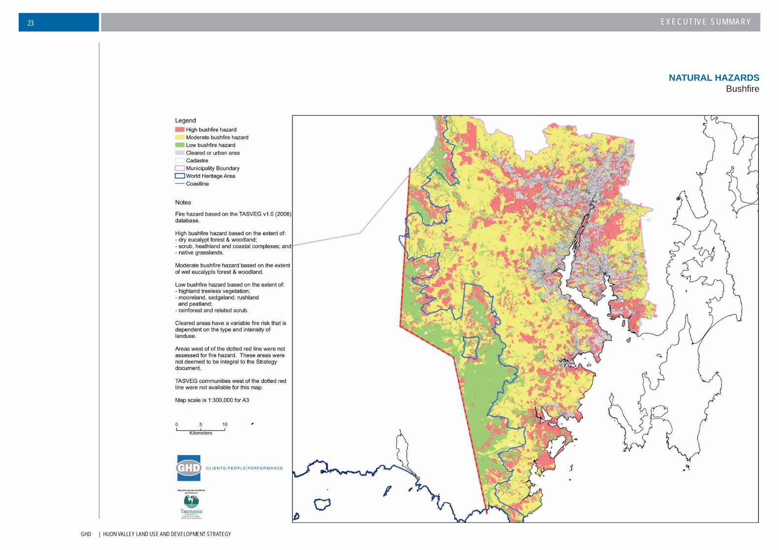
Bushfi re hazard generally has high public awareness. The physical and environmental setting of the municipal area makes it particularly susceptible. The bushfi re risk has increased even further in recent years with the infl ux of new residents into rural areas. Often located within or adjacent to standing vegetation, many lots have little bushfi re protection, are diffi cult to access and have insuffi cient water supply. In recent years both the Tasmania Fire Service (TFS) and local governments in Tasmania have been committed to minimising bushfi re hazard risk through the implementation of the TFS guidelines for development in bushfi re prone areas. It will be essential that these guidelines are integrated into the planning scheme and that new development is fi rstly required to establish the underlying bushfi re hazard potential of the area.
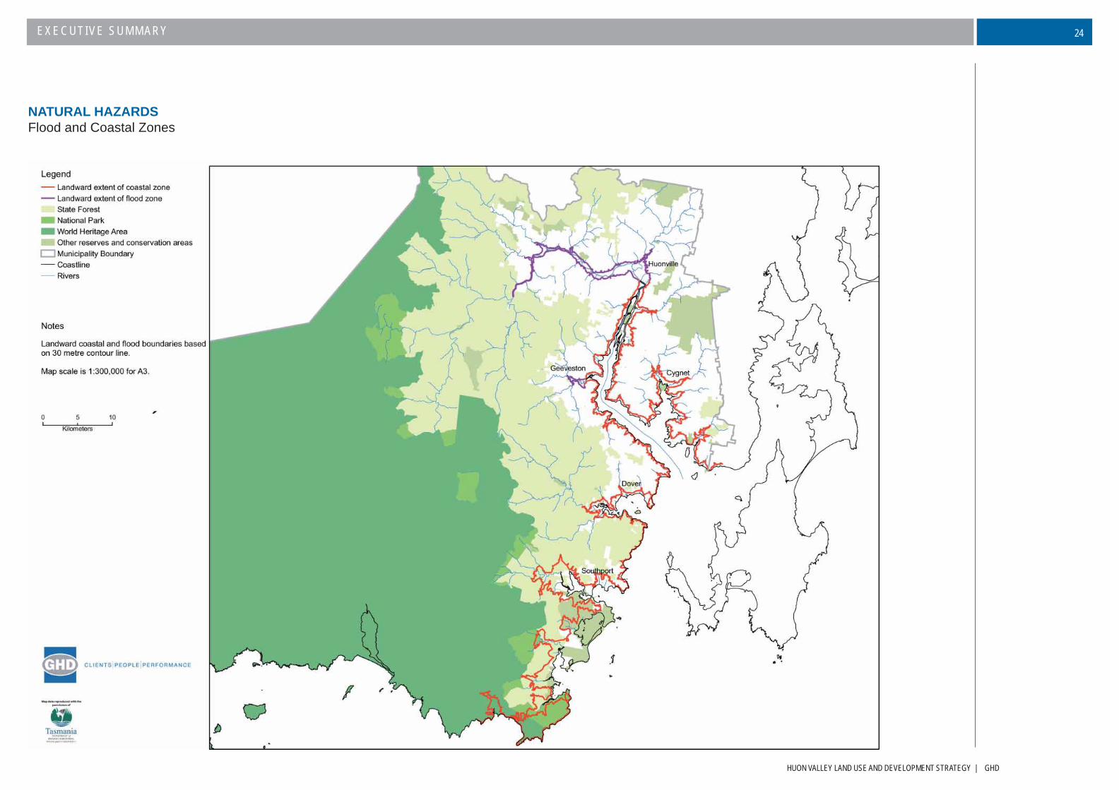
Another major hazard within the municipal area is that arising from water inundation, arising not only from fl ood events but storm surge and sea-level rise associated with climate change. The municipal area has an extensive history of fl ood events and while the severity of such fl ood events has lessened with the damming of the Huon River (Lake Pedder), there are still certain areas subject to regular inundation. Storm surge and sea level rise associated with climate change are planning issues that are becoming more apparent across all of Tasmania, given the high occurrence of development within our coastal areas. The likely increase in risk associated with storm surge and sea level rise and the ultimate economic costs of this risk means the Strategy needs to appropriately control the risk.
Ultimately, the availability of appropriate technical information is critical to the assessment of potential natural hazards and this will need to be an ongoing priority for the Huon Valley Council. Information, in many cases, is not available and planning decisions will need to adopt a precautionary approach. This precautionary approach should ensure that the hazard risk be mitigated through structural or siting methods to avoid property loss or damage, lives being placed at risk or public health concerns being generated. Ultimately, though it will be necessary to restrict use and development in vulnerable areas.
NATURAL HAZARDSSummary
HUON VALLEY LAND USE AND DEVELOPMENT STRATEGY | GHD
EXECUTIVE SUMMARY 20
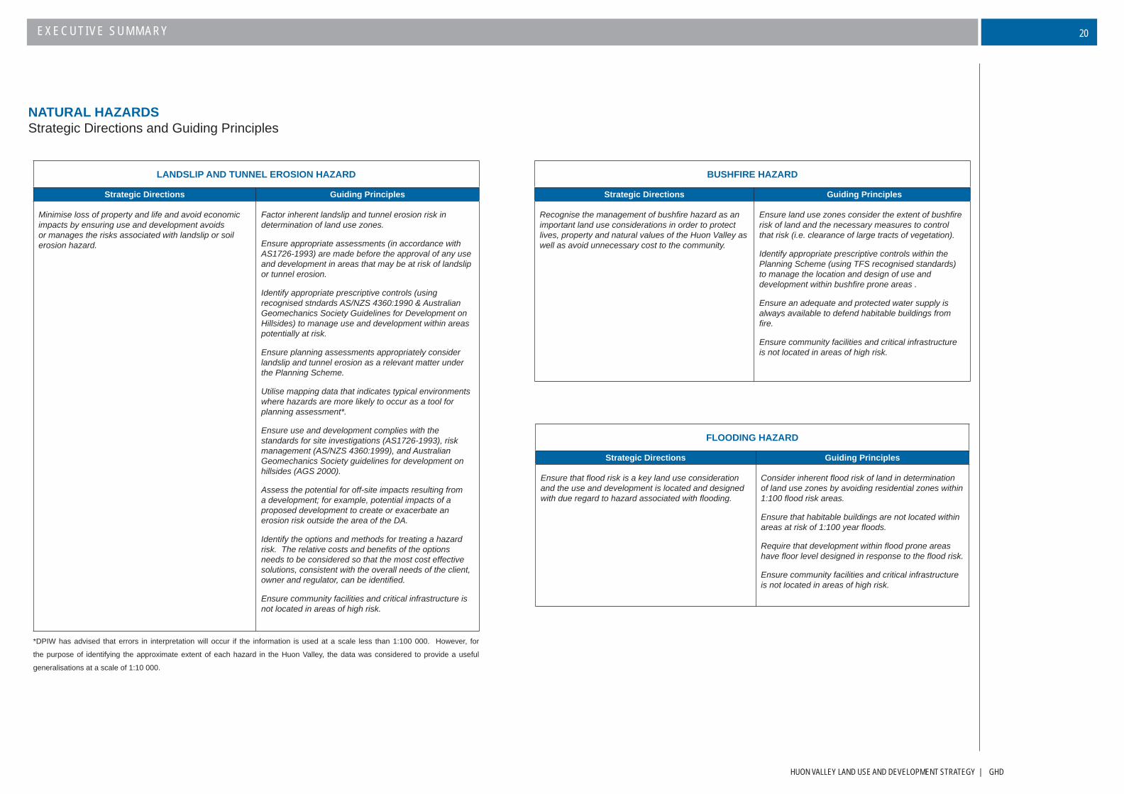
NATURAL HAZARDSStrategic Directions and Guiding Principles
LANDSLIP AND TUNNEL EROSION HAZARD
Strategic Directions Guiding Principles
Minimise loss of property and life and avoid economic impacts by ensuring use and development avoids or manages the risks associated with landslip or soil erosion hazard.
Factor inherent landslip and tunnel erosion risk in determination of land use zones.
Ensure appropriate assessments (in accordance with AS1726-1993) are made before the approval of any use and development in areas that may be at risk of landslip or tunnel erosion.
Identify appropriate prescriptive controls (using recognised stndards AS/NZS 4360:1990 & Australian Geomechanics Society Guidelines for Development on Hillsides) to manage use and development within areas potentially at risk.
Ensure planning assessments appropriately consider landslip and tunnel erosion as a relevant matter under the Planning Scheme.
Utilise mapping data that indicates typical environments where hazards are more likely to occur as a tool for planning assessment*.
Ensure use and development complies with the standards for site investigations (AS1726-1993), risk management (AS/NZS 4360:1999), and Australian Geomechanics Society guidelines for development on hillsides (AGS 2000).
Assess the potential for off-site impacts resulting from a development; for example, potential impacts of a proposed development to create or exacerbate an erosion risk outside the area of the DA.
Identify the options and methods for treating a hazard risk. The relative costs and benefi ts of the options needs to be considered so that the most cost effective solutions, consistent with the overall needs of the client, owner and regulator, can be identifi ed.
Ensure community facilities and critical infrastructure is not located in areas of high risk.
*DPIW has advised that errors in interpretation will occur if the information is used at a scale less than 1:100 000. However, for
the purpose of identifying the approximate extent of each hazard in the Huon Valley, the data was considered to provide a useful
generalisations at a scale of 1:10 000.
BUSHFIRE HAZARD
Strategic Directions Guiding Principles
Recognise the management of bushfi re hazard as an important land use considerations in order to protect lives, property and natural values of the Huon Valley as well as avoid unnecessary cost to the community.
Ensure land use zones consider the extent of bushfi re risk of land and the necessary measures to control that risk (i.e. clearance of large tracts of vegetation).
Identify appropriate prescriptive controls within the Planning Scheme (using TFS recognised standards) to manage the location and design of use and development within bushfi re prone areas .
Ensure an adequate and protected water supply is always available to defend habitable buildings from fi re.
Ensure community facilities and critical infrastructure is not located in areas of high risk.
FLOODING HAZARD
Strategic Directions Guiding Principles
Ensure that fl ood risk is a key land use consideration and the use and development is located and designed with due regard to hazard associated with fl ooding.
Consider inherent fl ood risk of land in determination of land use zones by avoiding residential zones within 1:100 fl ood risk areas.
Ensure that habitable buildings are not located within areas at risk of 1:100 year fl oods.
Require that development within fl ood prone areas have fl oor level designed in response to the fl ood risk.
Ensure community facilities and critical infrastructure is not located in areas of high risk.
GHD | HUON VALLEY LAND USE AND DEVELOPMENT STRATEGY
EXECUTIVE SUMMARY21
NATURAL HAZARDSStrategic Directions and Guiding Principles (cont)
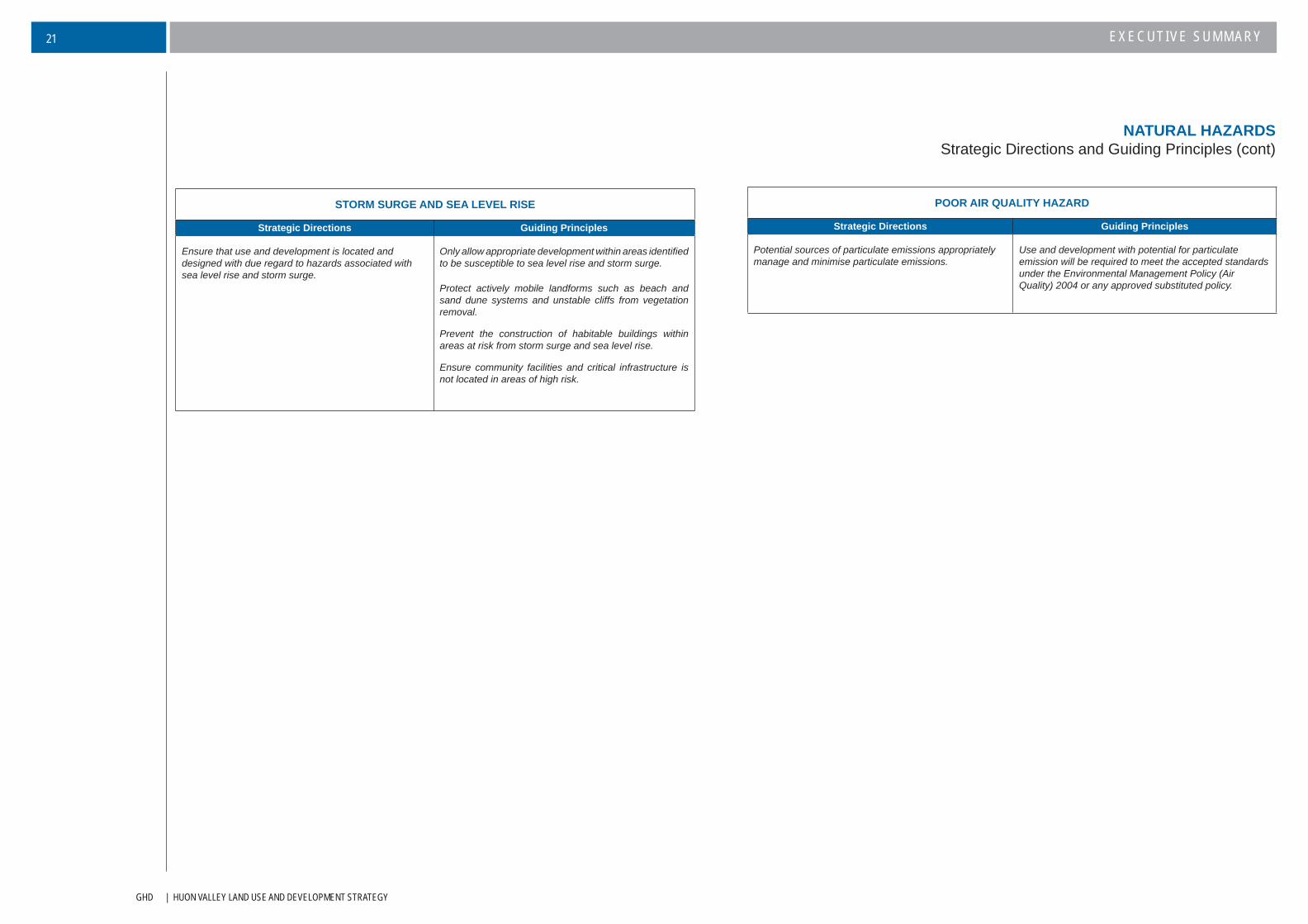
POOR AIR QUALITY HAZARD
Strategic Directions Guiding Principles
Potential sources of particulate emissions appropriately manage and minimise particulate emissions.
Use and development with potential for particulate emission will be required to meet the accepted standards under the Environmental Management Policy (Air Quality) 2004 or any approved substituted policy.
STORM SURGE AND SEA LEVEL RISE
Strategic Directions Guiding Principles
Ensure that use and development is located and designed with due regard to hazards associated with sea level rise and storm surge.
Only allow appropriate development within areas identifi ed to be susceptible to sea level rise and storm surge.
Protect actively mobile landforms such as beach and sand dune systems and unstable cliffs from vegetation removal.
Prevent the construction of habitable buildings within areas at risk from storm surge and sea level rise.
Ensure community facilities and critical infrastructure is not located in areas of high risk.

HUON VALLEY LAND USE AND DEVELOPMENT STRATEGY | GHD
EXECUTIVE SUMMARY 22
NATURAL HAZARDSSoil-Related
GHD | HUON VALLEY LAND USE AND DEVELOPMENT STRATEGY
EXECUTIVE SUMMARY23
NATURAL HAZARDSBushfi re
HUON VALLEY LAND USE AND DEVELOPMENT STRATEGY | GHD
EXECUTIVE SUMMARY 24
NATURAL HAZARDSFlood and Coastal Zones
GHD | HUON VALLEY LAND USE AND DEVELOPMENT STRATEGY
EXECUTIVE SUMMARY25
There are a range of heritage values that are important considerations in this strategy. They can be divided into four
categories: Aboriginal; European Heritage; cultural and natural Landscapes.
The municipal area is rich in Aboriginal heritage values. At present there are some 73 recorded sites within the
greater Huon Valley area and there are most likely a plethora of unknown sites. The known areas comprise of Quarry
sites, Isolated Artefacts, Artefact Scatters, Occupation Shelters and Midden sites. Considering the sensitivity of
Aboriginal heritage sites, it is necessary to take a precautionary approach to new developments, particular those
around coastal areas. Such an approach is provided for within the Aboriginal Relics Act 1975.
European heritage considers both cultural and built heritage. European cultural values in the municipal area are
largely based on the forest, agricultural and maritime industries, all which featured heavily in the historical evolution
of the area since European settlement. Heritage signifi cance is also more than just individual structures and it will
therefore be important that the protection of heritage areas are considered with new use and development.
European settlement throughout the Huon Valley has also contributed heavily to cultural landscapes. From a visual
perspective Huon Valley is recognised for its unique cultural landscapes, which are often central to a community’s
sense of place.
Also important to the community and the tourism economy are the natural landscapes throughout the Huon Valley.
High quality natural landscapes throughout the municipal area include Adamsons Peak, Sleeping Beauty, Hartz
Mountains, Port Esperance, the Huon River and its Estuary and the Tasmanian Wilderness World Heritage Area.
This Strategy, although providing a listing of all current identifi ed cultural heritage places, does not attempt to provide
a detailed study of heritage values across the municipal area. This requires additional time and resources, which is
not essential to the preparation of a new Planning Scheme. A more detailed study should be a priority for Council
over the coming years as a basis for a future planning scheme amendment.
A list of places of heritage signifi cance is provided as appendices to the main document. This list, however only provides for existing identifi ed heritage listed places under the existing Planning Schemes and the Tasmanian Heritage Register. As there has been no recent systematic review of cultural heritage items in the Huon Valley, particularly those with local signifi cance, the Council should consider commissioning a full Heritage Study for the Huon Valley area for input into the fi rst review of the new Planning Scheme.
HERITAGESummary
HUON VALLEY LAND USE AND DEVELOPMENT STRATEGY | GHD
EXECUTIVE SUMMARY 26
HERITAGEStrategic Directions and Guiding Principles
ABORIGINAL HERITAGE
Strategic Directions Guiding Principles
Ensure that sites and artefacts of Aboriginal Heritage Signifi cance are managed appropriately into the future through an integrated approach to management.
Council, relevant state agencies and the Aboriginal community work together to identify areas of sensitivity.
Incorporate provisions into the planning scheme to allow Council to request Aboriginal heritage surveys for any proposals involving substantial subdivision of land, coastal development, or signifi cant disturbance of land outside settlement boundaries, or as considered generally appropriate.
Adopt an integrated approach to management with State Government and the Aboriginal community to ensure that important sites and artefacts are managed appropriately into the future.
EUROPEAN AND BUILT HERITAGE
Strategic Directions Guiding Principles
Recognises the various economic benefi ts associated with managing the cultural heritage assets of the Huon Valley in an appropriate manner.
The social benefi ts of appropriate cultural heritage management are also recognised. Being integral to people’s sense of place and pride, the community should be involved in the management processes.
Sites of heritage signifi cance need to be protected against inappropriate development – this also includes sites of geo-conservation signifi cance, historic value and those with unique environmental features.
Provide a framework for the establishment of statutory regulation over additional heritage areas of listed sites as they are identifi ed through appropriate studies.
Allow appropriate reuse of heritage buildings.
Ensure that the siting, scale, form and appearance of development of heritage listed properties and within heritage areas does not detract from those characteristics of the place that contribute to its cultural signifi cance.
Ensure that important built fabric is protected through the redevelopment of any heritage listed properties.
Provide for the protection of historic streetscapes.
CULTURAL LANDSCAPE AND NATURAL HERITAGE
Strategic Directions Guiding Principles
The Huon Valley landscapes are important in attracting residents and visitors and providing for a sense of place. Landscape values will therefore be protected as far as practicable.
Cultural landscape and natural heritage values provide important tourism opportunities that can be facilitated through the development approval process. The primary objective is to protect the inherent value of the landscape.
The Huon Valley’s geological assets need appropriate management to ensure the preservation of their value.
Ensure development is appropriately controlled in relation to the landscape setting, scenic corridors and visual amenity.
Development (including vegetation clearance) should not occur where it is visually intrusive and out of place within the surrounding landscape.
Development on hill faces, ridgelines, coastal bluffs, headlands and other prominent landforms should protect the visual qualities of such areas and to prevent erosion or excessive disturbance.
Protect geological sites of signifi cance from inappropriate development.
WORLD HERITAGE AREA CONSIDERATIONS
Strategic Directions Guiding Principles
The World Heritage Area is an important attracting feature and a coordinated response to management within the World Heritage Area is required between the relevant authorities.
The natural values on adjacent land needs to be maintained so as to complement the important heritage values and avoid any diverse impact on the World Heritage Area.
Ensure a coordinated approach to planning for land within and adjacent to the World Heritage Area to protect natural and cultural values.
GHD | HUON VALLEY LAND USE AND DEVELOPMENT STRATEGY
EXECUTIVE SUMMARY27
The provision, location, condition and capacity of physical infrastructure by Council and State Government,
has a major infl uence on use and development of land, levels of accessibility, amenity and ability to minimise
environmental impacts. This strategy has examined transport and road infrastructure separately to other forms
of infrastructure (i.e. water, sewerage etc). The strategy does however recognise that access to a safe and
effi cient transport system, an adequate supply of reticulated water and disposal of effl uent and stormwater are
prerequisites for sustainable economic and social development.
The transport system has had a major infl uence on the pattern of land use and economic development within
the municipal area and will continue to do so. The arterial road network and its maintenance will have a major
impact on providing long-term sustainable economic and social development in the Huon Valley, particular for the
resource based industries and tourism.
The road network is well developed, not affected by congestion and is subject to continuous upgrading to meet
increased demands and improved safety. There is potential for confl ict along the arterial road network between
commuter/tourist use and freight transportation. This has been evident with the concern over heavy vehicle
movements, particularly through settled areas (i.e. Huonville). This particular confl ict will be partially resolved
through alternative links (Plenty Link Road) and the potential development of Southwood.
To strategically plan for long-term investment and protection of the road network, a road hierarchy, which
incorporates State Government arterial roads, Council maintained arterial roads and Council maintained general
roads, will be developed. This hierarchy will be translated into a new planning scheme. In doing so the Strategy
recognises potential impacts, adjacent development and new accesses can have on the viability of these roads.
This particularly applies to new residential development which should be encouraged in areas an appropriate
distance away from major arterial road corridors.
The strategy also recognises that the transport system and the pattern of land development can affect quality of life,
economic development and the environment in real and direct ways by infl uencing:
The amount of time we spend travelling;
Disposal income for essential items;
Access to employment, education, essential services and social activities;
Personal mobility and interaction with family, friends and the community;
Amenity and quality of the environment;
The amount of greenhouse emissions; and
Cost of goods and services.
As a consequence an important element within this Strategy is the integration of land use and transport planning. In
order to achieve these principles as well as the major objectives under the RMPS of sustainable development, the
new planning scheme will include provisions to:
Reduce the growth in the distance and the number of journeys using motorised transport;
Promote increased accessibility and amenity;
Maximise the use of existing infrastructure;
Protect high-speed road corridors;
Encourage and promote alternative means of travel including walking, cycling and the use of
buses; and
Reduce reliance on travel by motor vehicle.
TRANSPORTSummary
HUON VALLEY LAND USE AND DEVELOPMENT STRATEGY | GHD
EXECUTIVE SUMMARY 28
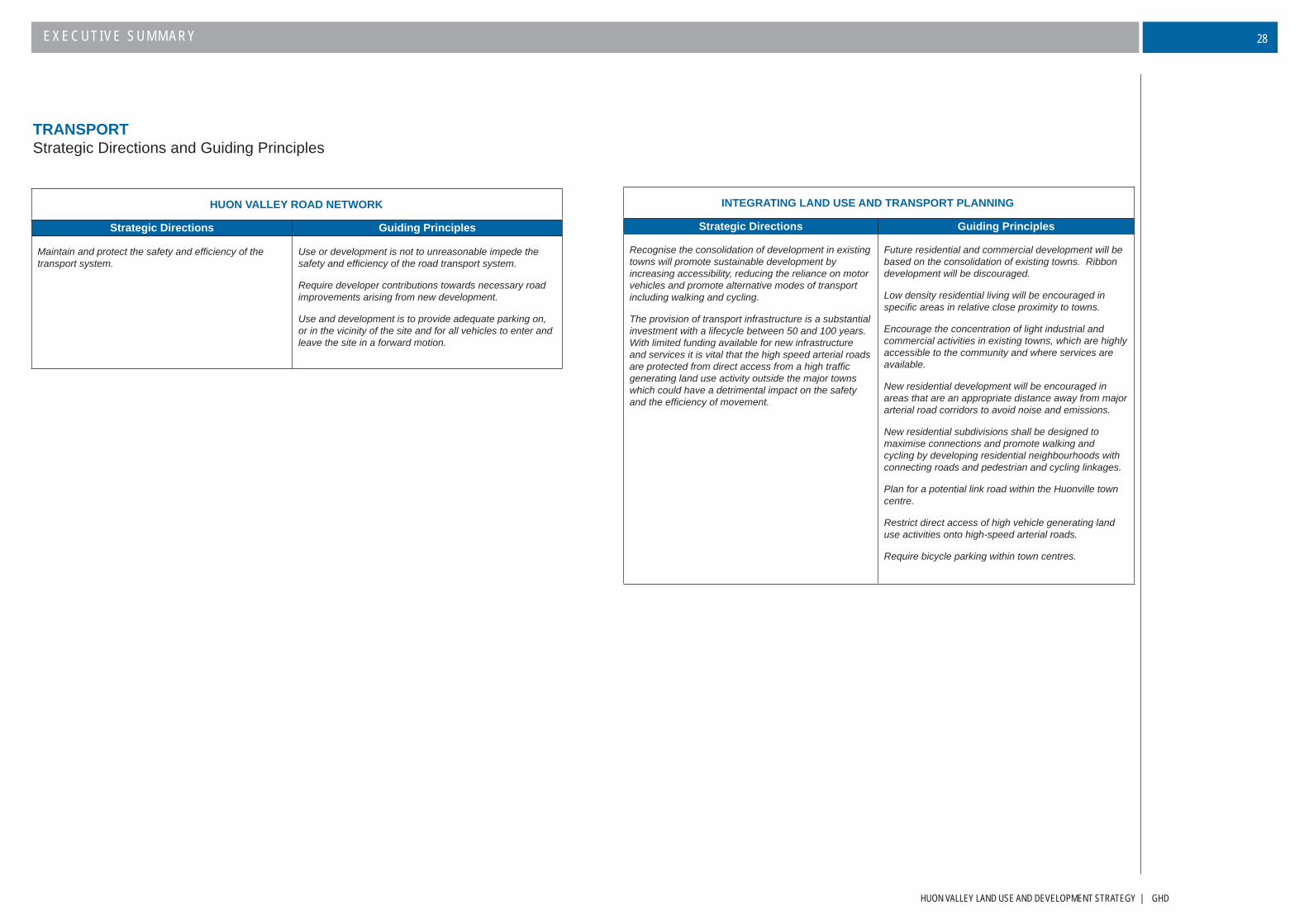
TRANSPORTStrategic Directions and Guiding Principles
HUON VALLEY ROAD NETWORK
Strategic Directions Guiding Principles
Maintain and protect the safety and effi ciency of the transport system.
Use or development is not to unreasonable impede the safety and effi ciency of the road transport system.
Require developer contributions towards necessary road improvements arising from new development.
Use and development is to provide adequate parking on, or in the vicinity of the site and for all vehicles to enter and leave the site in a forward motion.
INTEGRATING LAND USE AND TRANSPORT PLANNING
Strategic Directions Guiding Principles
Recognise the consolidation of development in existing towns will promote sustainable development by increasing accessibility, reducing the reliance on motor vehicles and promote alternative modes of transport including walking and cycling.
The provision of transport infrastructure is a substantial investment with a lifecycle between 50 and 100 years. With limited funding available for new infrastructure and services it is vital that the high speed arterial roads are protected from direct access from a high traffi c generating land use activity outside the major towns which could have a detrimental impact on the safety and the effi ciency of movement.
Future residential and commercial development will be based on the consolidation of existing towns. Ribbon development will be discouraged.
Low density residential living will be encouraged in specifi c areas in relative close proximity to towns.
Encourage the concentration of light industrial and commercial activities in existing towns, which are highly accessible to the community and where services are available.
New residential development will be encouraged in areas that are an appropriate distance away from major arterial road corridors to avoid noise and emissions.
New residential subdivisions shall be designed to maximise connections and promote walking and cycling by developing residential neighbourhoods with connecting roads and pedestrian and cycling linkages.
Plan for a potential link road within the Huonville town centre.
Restrict direct access of high vehicle generating land use activities onto high-speed arterial roads.
Require bicycle parking within town centres.

GHD | HUON VALLEY LAND USE AND DEVELOPMENT STRATEGY
EXECUTIVE SUMMARY29
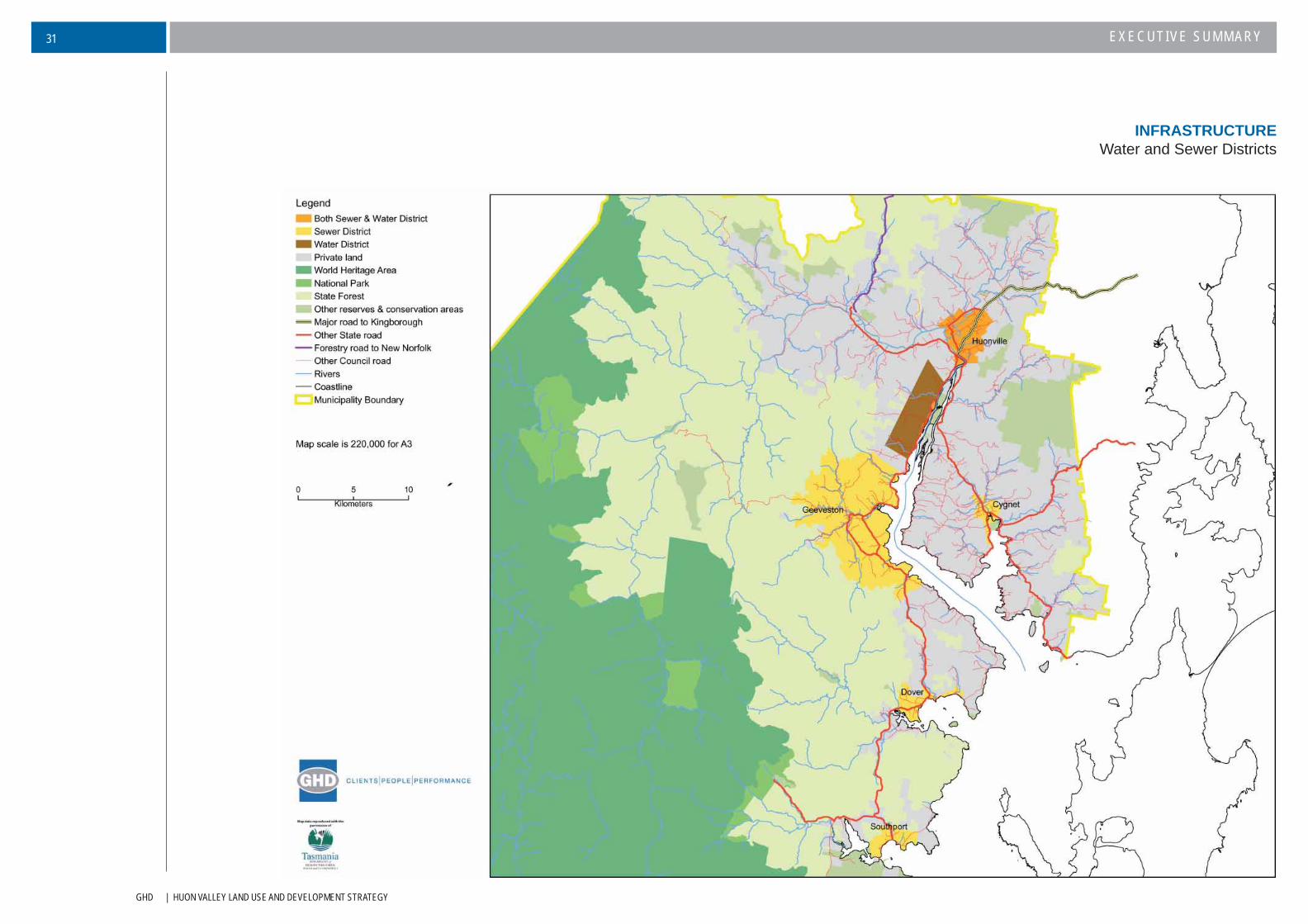
To provide economic and environmentally sustainable outcomes, future residential and commercial development
in the municipal area will predominantly occur in towns with the capacity to provide reticulated water, sewerage
reticulation and treatment and stormwater collection disposal.
At present a major environmental problem is associated with leachate from septic tanks where development
has occurred outside of serviced towns. To address the environmental problem, Council has pursued a policy
of extending sewerage services to settlements where this is a signifi cant problem, however this cost is not often
sustainable.
The quality and supply of water, sewerage treatment and disposal of stormwater varies considerably across
the municipal area. Like other small Councils in Tasmania, the Council is faced with a high demand for new
infrastructure, upgrading and maintenance of existing utilities and limited funding from a relatively small rate
base. It is the intent of this Strategy, to focus on maximising the use of existing infrastructure and encouraging
development where there is excess capacity of reticulated water and sewerage.
Reticulated sewerage is available at major towns of Huonville/Ranelagh, Cygnet, Franklin, Port Huon, Geeveston
and Dover, while all other settlements rely on disposal through septic tanks or domestic sized package treatment
plants. In terms of capacity, most of the sewerage treatments plants (located at Ranelagh, Cygnet, Geeveston,
Dover & Southport) suffer from excessive stormwater infi ltration. Measures need to be taken to address this
issue. Ultimately however, future development requiring extensions to existing reticulated sewerage schemes
will be dependent upon the capacity of the treatment plant, the fi nancial capacity of the scheme itself and the
environmental benefi ts accruing from such an extension. A key strategy within the Strategy is the application of
headwork charges for developments that impose extra long-terms costs to Council.
The availability of water supply is more extensive than reticulated sewerage. There are 11 water schemes in
place across the municipal area that service all the major settlements as well as some parts of Glen Huon,
Grove, Judbury and Mountain River. Verona Sands and Southport are not supplied with reticulated water. Given
the considerable investment in the provision of water infrastructure by Council, it will be important to maximise
the effectiveness and cost effi ciency of this investment by utilising existing infrastructure to its capacity and
encouraging future development within existing settlements (where there is the least amount of cost involved in
upgrading or extending water supply).
There are also numerous issues in regards to the long term provision of water in the municipal area. These
include:
The water reticulation system in some areas is sub-standard and therefore not capable of handling
further land use development without upgrading.
Council applies water restrictions on an annual basis across all water schemes. This is generally due
to reticulation problems where consumption in the lower levels drastically reduces available water to
the more elevated sections of the schemes.
Water conservation measures will be necessary to optimise the effi ciency of the existing infrastructure.
This might include water metering, domestic water tanks, improved plumbing systems and public
education.
Stormwater reticulation is poor across the whole municipal area. While major towns are provided with kerb and
channelling and some drains, there is no full reticulation system and no sediment or litter removal from urban
stormwater. There has been no strategic analysis of stormwater to ascertain impacts on the quality of receiving
waters. The only declared stormwater district in the municipal area is Huonville, but the stormwater reticulation
within Huonville requires upgrading and consideration of fl ooding potential.
As a matter of importance, the Strategy therefore encourages water sensitive urban design that provide a range of
alternatives to traditional approaches to stormwater management.
Waste management is a major environmental challenge for the municipal area not only in minimising residential waste
and encouraging reuse and recycling, but the pollution impacts from leachate at landfi ll sites. Council has adopted
a broad waste management strategy in 2001, which includes upgrading of waste transfer stations, rehabilitation of
former landfi ll sites containing leachate and introducing a kerbside waste collection.
There is therefore need to ensure that future residential development is design to be capable of kerbside collection.
It will also be important to ensure attenuation distances are applied for waste transfer/disposal sites and treatment
sites to protect sensitive uses from detrimental impacts.
INFRASTRUCTURESummary
Existing Council mapping of reticulated services is limited and is not reliable. Council therefore relies heavily upon site inspections. The upgrade of mapping of infrastructure and its capacity should be a priority for Council.
HUON VALLEY LAND USE AND DEVELOPMENT STRATEGY | GHD
EXECUTIVE SUMMARY 30
INFRASTRUCTUREStrategic Directions and Guiding Principles
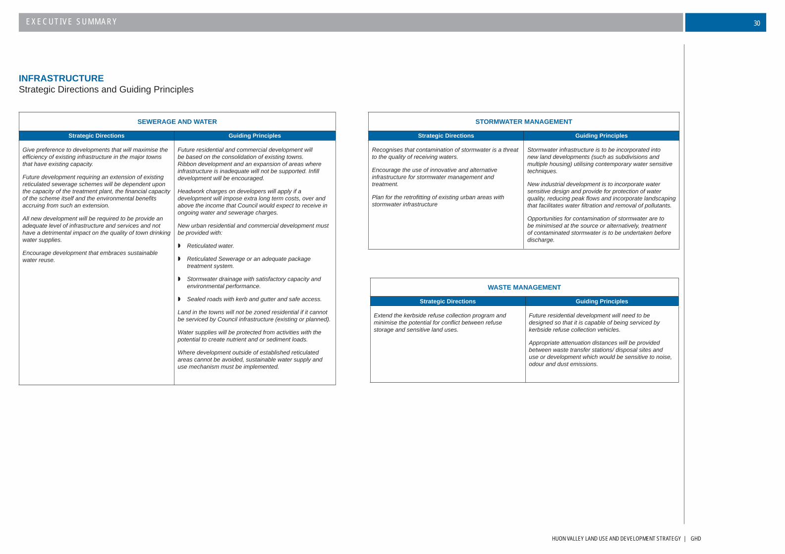
SEWERAGE AND WATER
Strategic Directions Guiding Principles
Give preference to developments that will maximise the effi ciency of existing infrastructure in the major towns that have existing capacity.
Future development requiring an extension of existing reticulated sewerage schemes will be dependent upon the capacity of the treatment plant, the fi nancial capacity of the scheme itself and the environmental benefi ts accruing from such an extension.
All new development will be required to be provide an adequate level of infrastructure and services and not have a detrimental impact on the quality of town drinking water supplies.
Encourage development that embraces sustainable water reuse.
Future residential and commercial development will be based on the consolidation of existing towns. Ribbon development and an expansion of areas where infrastructure is inadequate will not be supported. Infi ll development will be encouraged.
Headwork charges on developers will apply if a development will impose extra long term costs, over and above the income that Council would expect to receive in ongoing water and sewerage charges.
New urban residential and commercial development must be provided with:
Reticulated water.
Reticulated Sewerage or an adequate package treatment system.
Stormwater drainage with satisfactory capacity and environmental performance.
Sealed roads with kerb and gutter and safe access.
Land in the towns will not be zoned residential if it cannot be serviced by Council infrastructure (existing or planned).
Water supplies will be protected from activities with the potential to create nutrient and or sediment loads.
Where development outside of established reticulated areas cannot be avoided, sustainable water supply and use mechanism must be implemented.
STORMWATER MANAGEMENT
Strategic Directions Guiding Principles
Recognises that contamination of stormwater is a threat to the quality of receiving waters.
Encourage the use of innovative and alternative infrastructure for stormwater management and treatment.
Plan for the retrofi tting of existing urban areas with stormwater infrastructure
Stormwater infrastructure is to be incorporated into new land developments (such as subdivisions and multiple housing) utilising contemporary water sensitive techniques.
New industrial development is to incorporate water sensitive design and provide for protection of water quality, reducing peak fl ows and incorporate landscaping that facilitates water fi ltration and removal of pollutants.
Opportunities for contamination of stormwater are to be minimised at the source or alternatively, treatment of contaminated stormwater is to be undertaken before discharge.
WASTE MANAGEMENT
Strategic Directions Guiding Principles
Extend the kerbside refuse collection program and minimise the potential for confl ict between refuse storage and sensitive land uses.
Future residential development will need to be designed so that it is capable of being serviced by kerbside refuse collection vehicles.
Appropriate attenuation distances will be provided between waste transfer stations/ disposal sites and use or development which would be sensitive to noise, odour and dust emissions.
GHD | HUON VALLEY LAND USE AND DEVELOPMENT STRATEGY
EXECUTIVE SUMMARY31
INFRASTRUCTUREWater and Sewer Districts
HUON VALLEY LAND USE AND DEVELOPMENT STRATEGY | GHD
EXECUTIVE SUMMARY 32
Economic development within the municipal area has been closely related to the natural resource base. Agricultural, forestry and fi shing industries in the area have developed as a result of favourable climatic conditions, large areas of productive land and coastline, reliable water supplies and abundant fi sh and other marine line.
The natural resource base continues (in various guises) to provide the economic lifeblood of the municipal area as well as contributing to the economic well being of the State overall. Although agriculture, forestry and fi shing have seen a slight decline in more recent years, this sector continues to be the largest employer, accounting for 17.3% of the workforce (this include the aquaculture industry which accounts for 5.1%). The tourism sector and related development has also increasingly become important for the economy of the region. The latest 2006 Census data fi gures however do indicate an increasing percentage of the population employed in industries outside of the municipal area and this may be refl ective of the increasing desirability of the Huon Valley for commuters.
The main economic sectors that will be affected by, or impacted upon, by future use and development are forestry, agriculture, aquaculture, tourism and light industrial. Many of these sectors are dependent upon the sustainable management of natural resources. A major challenge for Council is the strategic development of all industries in the municipal area, while maintaining and enhancing these values.
Agricultural development was one of its earliest industries, developing in the mid 1880s following clearance of land from the early forestry industry. Agricultural industries based on apple, berry fruits, stone fruits and hops were soon established. The fi rst orchards were planted in the later 1830s near Garden Island Creek, growing steadily until the late 1930s when apple and pear orchards stretched almost continuously from Grove to Geeveston and from Huonville to Cygnet.
The opening of the world economy in the 1970s and international policy changes saw a signifi cant adverse impact upon the apple industry in the municipal area. The following 30 years has seen a decline in the industry which has only been partially arrested through the development of new markets, new varieties and a move towards larger orchards. Apple production however remain a signifi cant contributor to the value of agriculture in Tasmania with the production of over 45,000 tonnes of apples in Tasmania for 2004-2005 (ABS 2005 Agriculture Census). Latest fi gures by the Apple and Pear Association Industry (2004) show that the Huon Valley still accounts for 90% of the Tasmanian crop.
It is therefore important that there is a continuing diversifi cation of agricultural enterprises within the municipal area. Traditional orcharding and grazing activities are gradually being replaced with non-traditional farming enterprises such as viticulture, cherries, hazelnut and olives, many of which are undertaken using organic farming practices. These non-traditional and niche markets also feed into the tourism sector.
Given that the agricultural sector is the major economic driver and employer for municipal area and is important in the overall context of the State, the protection of agricultural land is an integral element of a new planning scheme. Specifi c issues that will need to be addressed include:
Maintaining the economic viability of landholdings; Maintaining Class 3, 4 & 5 land for agricultural purposes; Maintaining fl exibility for industry to respond to market demands; and Encouraging downstream processing.
The forestry sector has been a signifi cant element in the economic development of the municipal area. Today, the majority of forestry activity is undertaken by Forestry Tasmania within the Huon Forest District. State Forests account for 22.5% of land in the municipal area; 37% of State Forests are managed primarily for protection and the remainder utilised for production. Traditionally forestry activity was based around old growth and regenerated native forests, however an increase in plantations has arisen, particularly on private land (Private Timber Reserves), although it still only account for 0.8% of the municipal area and 3.1% of the total private plantation production in Tasmania.
Forestry activities are generally outside the scope of planning controls, although forestry activities on private land that is not declared as a Private Timber Reserve prior to a planning scheme coming into effect are subject to local planning controls. Key planning issues to be addressed will include: confl ict of different land uses, traffi c on public roads, conditions and extent of biodiversity, landscape values, water quality, fi re risk management and weed management.
Aquaculture, unlike the agriculture and forestry sectors is a more recent industry, with salmon farms established in the Huon River in the 1980s. Over the past 20 years, this sector has seen considerable growth and the Huon Valley/D’Entrecasteaux Channel is now a signifi cant part of the Tasmanian marine farming industry. While marine farms themselves are not subject to local planning controls, land based associated activities (including processing) are. This Strategy therefore encourages, marine farms and associated land based development to be undertaken together at a strategic level, to reduce confl icts in environmentally/visually sensitive areas.
Manufacturing or light industrial activity is the other major employer in the municipal area (approximately 9% of the workforce). While there is a general feeling that heavy or noxious industry should be discouraged in order to maintain the clean green image of the area, it is important that there is suffi cient land for other industrial type activities to ensure a broader and stronger economic and employment base. There is clearly insuffi cient industrial land in Huonville where the demand is greatest and it will be important for these types of activities to be located in areas where there is suffi cient servicing and distance from sensitive uses. There will also be an increasing demand for rural industry. The location of rural processing type of industrial uses should be in proximity to its resource base.
Overall the Strategy identifi es a clear direction for economic development in all sectors and at all scales throughout the municipal area to provide for surety in economic investment, protection of natural values and the maintenance of amenity for residents.
THE ECONOMYSummary
GHD | HUON VALLEY LAND USE AND DEVELOPMENT STRATEGY
EXECUTIVE SUMMARY33
THE ECONOMYStrategic Directions and Guiding Principles
AGRICULTURAL DEVELOPMENT
Strategic Directions Guiding Principles
Recognises the importance of maintaining productive and viable agricultural areas and ensure that the State Protection of Agricultural Land Policy (PAL) is implemented.
To do this, Council will ensure that
Subdivision of agricultural land will not result in the loss of land to agricultural production.
Agricultural land is protected from encroachment by residential use and development.
A precautionary approach is adopted.
The planning scheme will identify land allocated to ‘Rural Living’ and ‘Low Density Residential’ zones, such that subdivision should not be necessary in the Rural Resource Zone.
Council will prevent further incompatible development within identifi ed rural resource zones.
Maintain or increase the productive capacity of agricultural land and allow farmers to undertake agricultural activities without being unreasonably constrained by confl icts with adjoining non-agricultural land users.
Minimise scope for confl ict by developing a defi ned boundary and buffer area between agricultural and residential areas.
Buffer areas are to be maintained where residential areas adjoin the rural resource zone.
Buffer areas are to be suitably designed, maintained and protected and that natural features on residential edges are retained.
Provided agricultural activities are best practice, ensure that new adjacent uses do not have an expectation of modifi cation to these practices to an extent which threatens effi cient agricultural operations.
FORESTRY PRACTICES ON PRIVATE LAND NOT WITHIN APTR
Strategic Directions Guiding Principles
Provide for the minimising of external impacts while still providing for ongoing sustainable forest industry within the Huon Valley.
Minimise impact on agricultural and residential areas.
Minimise any negative visual impact.
Minimise impact on public roads.
Maintain biodiversity of remnant native vegetation on private land. This is particularly relevant to those areas containing communities of conservation signifi cance.
Maintain water quality.
Minimise the risk of bushfi res.
AQUACULTURE
Strategic Directions Guiding Principles
Maintain or increase the productive capacity of aquaculture industries, while protecting freshwater, estuarine and marine water quality values as a requirement of a development application.
Provide for the minimisation of external impacts while still providing for ongoing sustainable aquaculture industry within the Huon Valley.
Integration of marine farm planning and land based development should be promoted at a strategic level. This can help reduce confl icts between marine farms and the demands for associated land based facilities in environmentally/visually sensitive areas.
Any redevelopment of existing shore based facilities should be able to demonstrate a high level of environmental performance in respect of scenic values, water quality, coastal processes and heritage.
HUON VALLEY LAND USE AND DEVELOPMENT STRATEGY | GHD
EXECUTIVE SUMMARY 34
THE ECONOMYStrategic Directions and Guiding Principles (cont.)
DOWNSTREAM PROCESSING
Strategic Directions Guiding Principles
Provide for the development of industries that add value to the key export sectors of forest and food industry and fl exibility for development close to raw materials in rural areas, subject to acceptable environmental and amenity impacts.
Ensure that there is fl exibility to provide for farm diversifi cation including manufacturing, processing and sale of primary produce within the rural resource zone subject to satisfactory traffi c safety and amenity standards.
LIGHT INDUSTRIAL DEVELOPMENT
Strategic Directions Guiding Principles
Identify a particular site for a light industrial ‘estate’ that would be available for future demands and which would be suitable for the larger industrial enterprises within the Huonville area.
Identify areas for industrial uses in proximity to the other major towns.
Minimise the distance between rural industry and its associated resource base.
Identify land suitable for a light industrial estate close to Huonville that can connect to reticulated services.
Identify land appropriate for light industrial zoning where visual, landscape and natural values have already been compromised.
Ensure fl exibility for consideration of rural industry uses within the rural resource zone.
SMALL BUSINESS
Strategic Directions Guiding Principles
Encourage and support small business in appropriate locations.
Provide fl exibility for home occupations and small businesses across the planning area subject to assessment of the impact on the amenity of the area, the transport network and the environment.
REUSE OF BUILDINGS
Strategic Directions Guiding Principles
Recognise and encourage the need for adaptive reuse of buildings in the Huon Valley.
Consider the reuse of redundant buildings for employment generating uses, subject to consideration of the effects on the amenity of the area, traffi c generation, impact on any heritage values and the capacity of the conversion to meet building regulations.
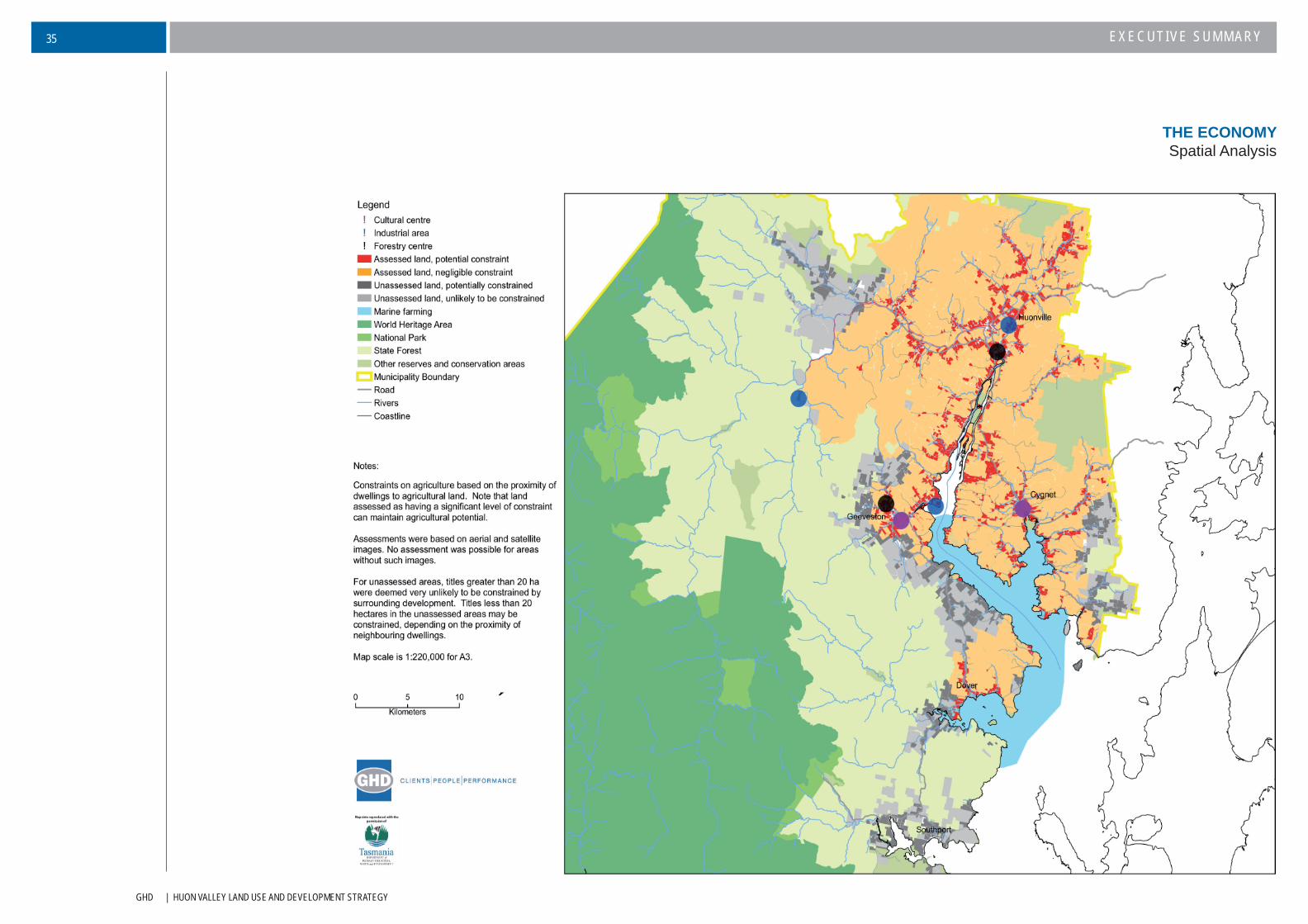
GHD | HUON VALLEY LAND USE AND DEVELOPMENT STRATEGY
EXECUTIVE SUMMARY35
THE ECONOMYSpatial Analysis
HUON VALLEY LAND USE AND DEVELOPMENT STRATEGY | GHD
EXECUTIVE SUMMARY 36
The Huon Valley has a very strong tourism product that forms an important component of the region’s economy. It
will continue to be a major long-term economic driver for the area. Given its integral role in the attractiveness of the
region for visitors this strategy recognises the importance of maintaining and enhancing the natural, scenic, heritage
value and amenity of the municipal area.
The Huon Valley is an identifi ed destination within Tasmania’s tourism strategy as a themed tourist trail and is
branded as the Huon Trail. The Huon Trail connects Hobart with Huon Valley and Kingborough areas and provides
a co-ordinated approach to marketing tourist products and experiences in the region. The touring route also includes
the far south area, which in more recent tourism strategies, is identifi ed as a key future development area.
Huon Valley both benefi ts and suffers from the fact that it is so close to the Hobart region. The area is seen as a day
destination and consequently has the lowest overnight stay record in Tasmania. This results in many smaller tourism
operators not achieving their potential, as visitors tend to concentrate on the larger and better-promoted operations.
The identifi cation of the far south area as a key future tourism area, is partially driven by the need the encourage
visitors to extend their stay. The far south area is the furthest part of Huon Valley, geographically from Hobart and
creates a greater need for overnight accommodation.
An increase in overnight visitors results in stimulating more expenditure than day visitors and will create more jobs
in the valley. A number of specifi c development opportunities are restricted under current planning controls (i.e.
farm stay type accommodation). Therefore the Strategy encourages good, innovative developments that add to the
overall tourism experience, without detriment to other key industries. Rural based and eco-tourism developments
will be encouraged, particularly outside of existing towns. Indeed, new tourism developments outside of settlements
must be environmentally sustainable to protect the brand values.
Overall there is a clear need for a range of tourist accommodation of various standards and ratings through the
municipal area to meet the varying needs of visitors.
Providing and maintaining the integrity of tourism attractions is strategically important. Attractions provide a reason
why visitors go to an area and are central to the tourism experience. The municipal area currently has a number of
tourism attractions, including Tahune Air Walk and Hastings Cave. Council will support new attractions that build on
the Huon Trail brand and that recognise and enhance natural and cultural values of the region.
Through the planning approval process Council can make sure that new development in the municipal area
has a positive infl uence and protects important landscapes and streetscapes. Poorly designed buildings and
inappropriately located development can have an adverse impact on scenic qualities, heritage, amenity of
communities and the tourism industry. A key example is the unnecessary and unsightly signage spread across
the municipal area, particularly on the main tourist routes. The Council will promote development that is designed
to complement the qualities of natural and cultural heritage values of municipal area and protect scenic road
touring corridors. Development, which would adversely affect the landscape character and amenity of the area
will generally not be supported as would proposals which lead to the loss of trees or forests of high nature
conservation or landscape value.
SUSTAINABLE TOURISMSummary
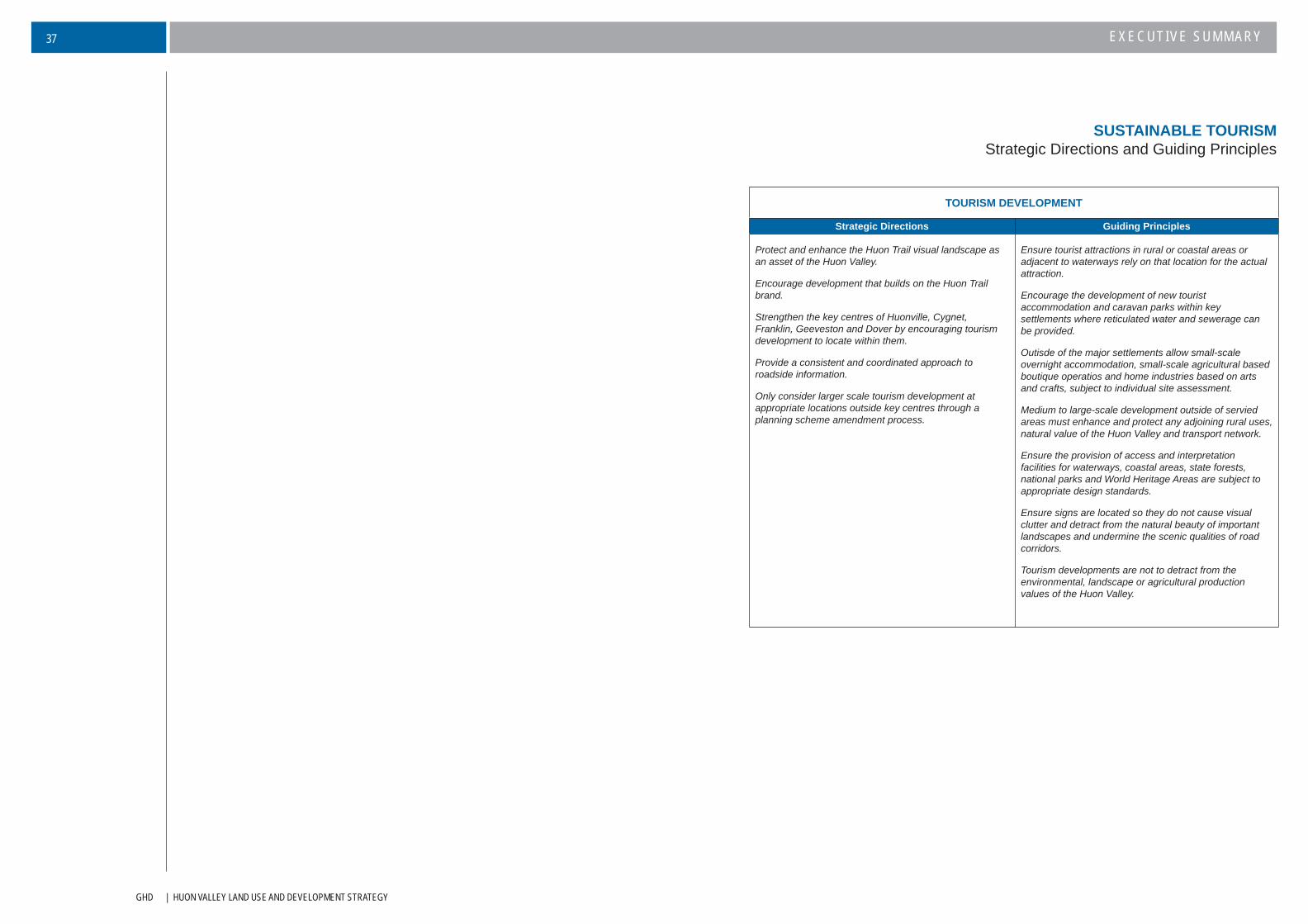
GHD | HUON VALLEY LAND USE AND DEVELOPMENT STRATEGY
EXECUTIVE SUMMARY37
SUSTAINABLE TOURISMStrategic Directions and Guiding Principles
TOURISM DEVELOPMENT
Strategic Directions Guiding Principles
Protect and enhance the Huon Trail visual landscape as an asset of the Huon Valley.
Encourage development that builds on the Huon Trail brand.
Strengthen the key centres of Huonville, Cygnet, Franklin, Geeveston and Dover by encouraging tourism development to locate within them.
Provide a consistent and coordinated approach to roadside information.
Only consider larger scale tourism development at appropriate locations outside key centres through a planning scheme amendment process.
Ensure tourist attractions in rural or coastal areas or adjacent to waterways rely on that location for the actual attraction.
Encourage the development of new tourist accommodation and caravan parks within key settlements where reticulated water and sewerage can be provided.
Outisde of the major settlements allow small-scale overnight accommodation, small-scale agricultural based boutique operatios and home industries based on arts and crafts, subject to individual site assessment.
Medium to large-scale development outside of servied areas must enhance and protect any adjoining rural uses, natural value of the Huon Valley and transport network.
Ensure the provision of access and interpretation facilities for waterways, coastal areas, state forests, national parks and World Heritage Areas are subject to appropriate design standards.
Ensure signs are located so they do not cause visual clutter and detract from the natural beauty of important landscapes and undermine the scenic qualities of road corridors.
Tourism developments are not to detract from the environmental, landscape or agricultural production values of the Huon Valley.
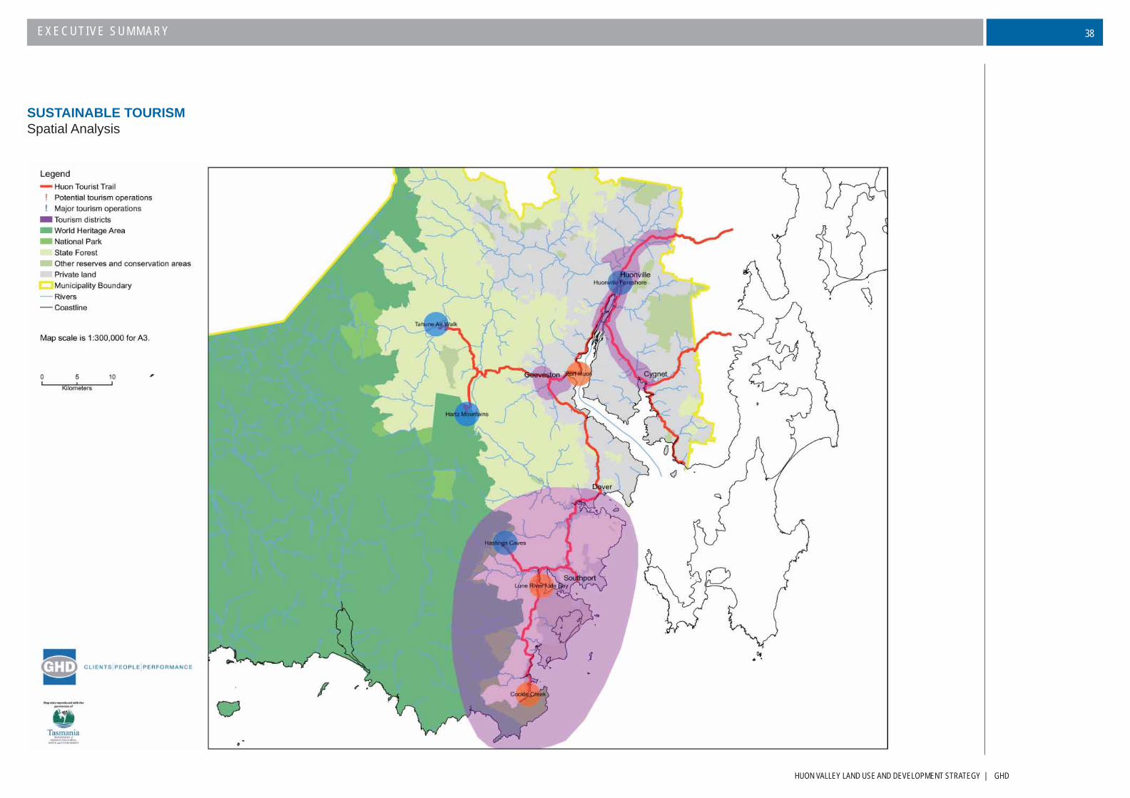
HUON VALLEY LAND USE AND DEVELOPMENT STRATEGY | GHD
EXECUTIVE SUMMARY 38
SUSTAINABLE TOURISMSpatial Analysis
GHD | HUON VALLEY LAND USE AND DEVELOPMENT STRATEGY
EXECUTIVE SUMMARY39
The municipal area is not only experiencing demographic and household changes which affect the demand
for residential development, but is also experiencing a small amount of growth. The municipal area has been
rejuvenated in the past few years with improved economic circumstances and there are new residents coming to
live in the Huon Valley.
Demand for residential sites in rural areas with water or mountain views has grown. This demand has been
assisted by improvements in road networks for commuters and the changing nature of planning regulation in
the Kingborough municipal area. The dominant form of residential development over the past decade has been
associated with small lot rural living and low density residential, particularly around Grove, Mountain River,
Ranelagh, Glen Huon, Cradoc and Cygnet. Consequently the number of properties in these areas used for
agricultural purposes has decreased.
At present there are over 3000 vacant lots in the municipal area that are capable under the current planning
controls of having a house built upon them. Approximately 2/3 of these lots are below 10 hectares. There has
been a clear tendency to over subdivide in rural areas and even taking into account possible physical constraints
on building on these lots, there is ample supply of land within the municipal area without having to encourage
further subdivision of rural land.
Many former shack/holiday settlements are also being redeveloped and occupied on an increasingly permanent
basis. The conversion of shack leases to freehold title under the Crown Land Shacks Categorisation Program has
assisted this trend.
The increasing fragmentation of land through Huon Valley for residential purposes is the most signifi cant issue
for for this Strategy to address. Not only does the spread of residential development from towns to rural living
dilute the spirit of both the town and country it can compromise the economic development of the municipal area
and its natural values. It is acknowledged that many subdivisions have occurred as a result of economic impacts
upon traditional agricultural activities (i.e. orcharding), however there are many non-traditional and/or alternative
agricultural activities that can occur on lots that are too small for more traditional agricultural activities.
Specifi cally subdivision of rural land for residential purposes has produced a number of issues that will need to be
addressed by the new planning scheme. These include:
Loss of better quality agricultural land.
Land management issues.
Land use confl ict with legitimate rural operations.
Inappropriate subdivision design of low-density developments.
The clearance of coastal vegetation results in the loss of native habitat and ecological values, erosion
and visual amenity.
Increased levels of rural-residential development places increased and more ineffi cient demands on
Council/public infrastructure.
There is the potential for increased risk from hazards such as bushfi re, fl ooding and landslip.
It is recognised that the demand for rural living is likely to continue due to the desire of new residents to seek an
alternative lifestyle in attractive environmental settings. The best approach is therefore to manage the demand to
ensure that there are minimal impacts.
However, it is recognised that in contemporary society, living options outside of settlements have and continue to
remain desirable, for many reasons. Indeed in recent years the municipal area has offered a rural residential lifestyle
for commuters to Greater Hobart as well as for ‘tree’ and ‘sea’ changers. Moreover there are already areas within
the municipal area that have either be fettered or fragmented to an extent where agricultural potential is severely
constrained.
This demand for rural living is likely to continue at least in the medium term, given the desire of new residents seeking
an alternative lifestyle in an attractive environmental setting. It is therefore considered that the best approach is to
manage the demand in a way that addresses as far as practicable the detrimental impacts upon the Huon Valley
values and long term economic potential, i.e. land that is clearly good un-fettered land should not be used for rural
living purposes.
PROVIDING FOR HOUSING NEEDSSummary
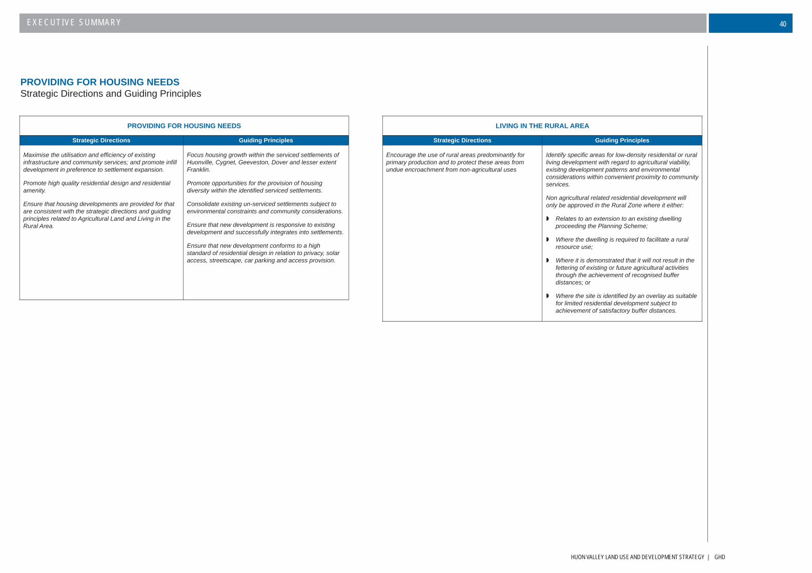
HUON VALLEY LAND USE AND DEVELOPMENT STRATEGY | GHD
EXECUTIVE SUMMARY 40
PROVIDING FOR HOUSING NEEDSStrategic Directions and Guiding Principles
PROVIDING FOR HOUSING NEEDS
Strategic Directions Guiding Principles
Maximise the utilisation and effi ciency of existing infrastructure and community services; and promote infi ll development in preference to settlement expansion.
Promote high quality residential design and residential amenity.
Ensure that housing developments are provided for that are consistent with the strategic directions and guiding principles related to Agricultural Land and Living in the Rural Area.
Focus housing growth within the serviced settlements of Huonville, Cygnet, Geeveston, Dover and lesser extent Franklin.
Promote opportunities for the provision of housing diversity within the identifi ed serviced settlements.
Consolidate existing un-serviced settlements subject to environmental constraints and community considerations.
Ensure that new development is responsive to existing development and successfully integrates into settlements.
Ensure that new development conforms to a high standard of residential design in relation to privacy, solar access, streetscape, car parking and access provision.
LIVING IN THE RURAL AREA
Strategic Directions Guiding Principles
Encourage the use of rural areas predominantly for primary production and to protect these areas from undue encroachment from non-agricultural uses
Identify specifi c areas for low-density residenital or rural living development with regard to agricultural viability, exisitng development patterns and environmental considerations within convenient proximity to community services.
Non agricultural related residential development will only be approved in the Rural Zone where it either:
Relates to an extension to an existing dwelling proceeding the Planning Scheme;
Where the dwelling is required to facilitate a rural resource use;
Where it is demonstrated that it will not result in the fettering of existing or future agricultural activities through the achievement of recognised buffer distances; or
Where the site is identifi ed by an overlay as suitable for limited residential development subject to achievement of satisfactory buffer distances.

GHD | HUON VALLEY LAND USE AND DEVELOPMENT STRATEGY
EXECUTIVE SUMMARY41
PROVIDING FOR HOUSING NEEDSExisting Settlement Pattern

HUON VALLEY LAND USE AND DEVELOPMENT STRATEGY | GHD
EXECUTIVE SUMMARY 42
This strategy identifi es clear land use policies and directions for individual settlements within municipal area. These
policies and directions have primarily been formed upon the analysis of other key considerations in this strategy as
well as the previous Town Structure Plans study prepared by TBA Planner Pty Ltd.
Major settlements have been considered through the TBA Planners study and through township development plans
largely generated from within the local community. These plans emphasise the individuality and special features of
the respective towns and their fi ndings are included under the consideration of each town below.
Most minor settlements are purely residential in nature without even the most basic community services. Infrastructure
is principally limited to roads, power and telecommunications. Water supply is generally via domestic tanks with
effl uent disposed through use of septic tanks – often poorly constructed and maintained. Effl uent disposal heads a
list of environmental management problems being experienced in many of the minor settlements.
The preferred settlement strategy for the ongoing development within the Huon Valley can be summarised as
follows:
Major Settlements – Huonville, Cygnet, Franklin, Geeveston and DoverDevelopment is to be encouraged within existing serviced areas or where extensions to infrastructure is planned.
Urban growth boundaries have been identifi ed, and land identifi ed for future commercial, industrial, community and
residential uses. A range of other development opportunities, including streetscape projects have been identifi ed in
‘structure plans’ for these towns and will provide guidance to Council and the wider community to the desired future
pattern and character of development.
Minor Settlements – Port Huon, Glen Huon/Judbury, Southport, GroveDevelopment within these minor settlements is constrained by limited servicing and consequential environmental
impacts of development reliant on on-site disposal of effl uent. Whilst there is potential for an upgrade of
infrastructure in the Port Huon settlement, there are no plans for services being provided to the remaining
settlements. Development in all cases is strictly on the basis of in-fi ll opportunities, and in the absence of
infrastructure, within the environmental constraints imposed by proximity to the coast, high water tables, soil
characteristics and the like.
Hamlets and Other Small SettlementsVerona Sands, Garden Island, Randalls Bay, Eggs and Bacon Bay, Abels Bay, Charlotte Cove, Rocky Bay, Deep
Bay, Surveyors Bay, Roaring Beach and Little Roaring Beach No further subdivision is to be permitted, and
development is only on the basis of existing vacant lots within developed areas, and subject to meeting strict
environmental criteria.
In support of the settlement strategy articulated above, the Strategy for residential development outside these
identifi ed settlements is outlined in the previous section (Providing for Housing Needs). In summary this is to
be controlled by the identifi cation of areas within which low density or rural residential use and development will
be permitted. Further the identifi cation of specifi c growth boundaries for all settlements will be integral to the
successful implementation of guiding principles identifi ed for each settlement. Outside these areas residential
development will only be permitted where it supports agricultural uses or is otherwise required to support an
existing approved use, for example a tourist operation.
SETTLEMENTSSummary
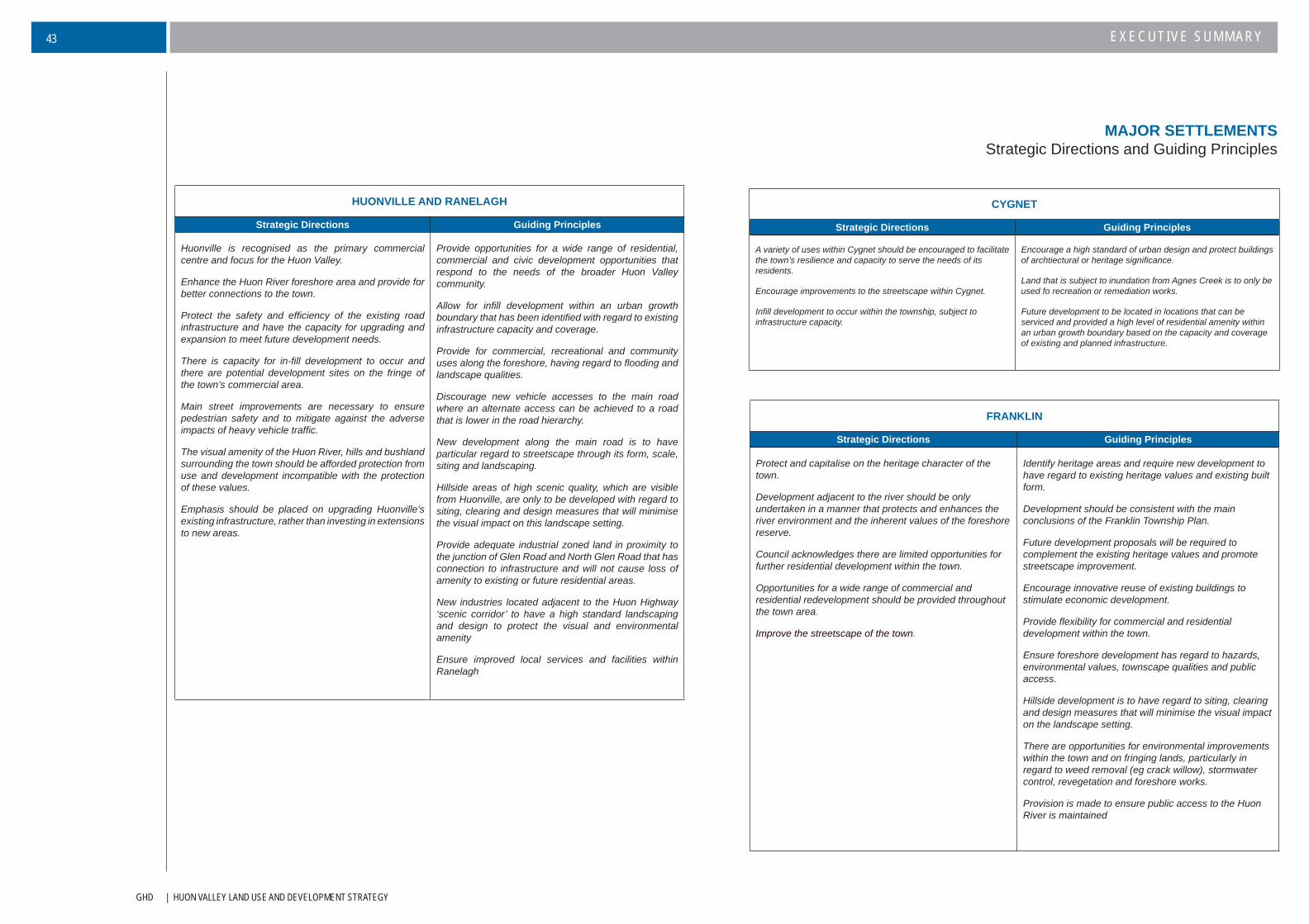
GHD | HUON VALLEY LAND USE AND DEVELOPMENT STRATEGY
EXECUTIVE SUMMARY43
CYGNET
Strategic Directions Guiding Principles
A variety of uses within Cygnet should be encouraged to facilitate the town’s resilience and capacity to serve the needs of its residents.
Encourage improvements to the streetscape within Cygnet.
Infi ll development to occur within the township, subject to infrastructure capacity.
Encourage a high standard of urban design and protect buildings of archtiectural or heritage signifi cance.
Land that is subject to inundation from Agnes Creek is to only be used fo recreation or remediation works.
Future development to be located in locations that can be serviced and provided a high level of residential amenity within an urban growth boundary based on the capacity and coverage of existing and planned infrastructure.
HUONVILLE AND RANELAGH
Strategic Directions Guiding Principles
Huonville is recognised as the primary commercial centre and focus for the Huon Valley.
Enhance the Huon River foreshore area and provide for better connections to the town.
Protect the safety and effi ciency of the existing road infrastructure and have the capacity for upgrading and expansion to meet future development needs.
There is capacity for in-fi ll development to occur and there are potential development sites on the fringe of the town’s commercial area.
Main street improvements are necessary to ensure pedestrian safety and to mitigate against the adverse impacts of heavy vehicle traffi c.
The visual amenity of the Huon River, hills and bushland surrounding the town should be afforded protection from use and development incompatible with the protection of these values.
Emphasis should be placed on upgrading Huonville’s existing infrastructure, rather than investing in extensions to new areas.
Provide opportunities for a wide range of residential, commercial and civic development opportunities that respond to the needs of the broader Huon Valley community.
Allow for infi ll development within an urban growth boundary that has been identifi ed with regard to existing infrastructure capacity and coverage.
Provide for commercial, recreational and community uses along the foreshore, having regard to fl ooding and landscape qualities.
Discourage new vehicle accesses to the main road where an alternate access can be achieved to a road that is lower in the road hierarchy.
New development along the main road is to have particular regard to streetscape through its form, scale, siting and landscaping.
Hillside areas of high scenic quality, which are visible from Huonville, are only to be developed with regard to siting, clearing and design measures that will minimise the visual impact on this landscape setting.
Provide adequate industrial zoned land in proximity to the junction of Glen Road and North Glen Road that has connection to infrastructure and will not cause loss of amenity to existing or future residential areas.
New industries located adjacent to the Huon Highway ‘scenic corridor’ to have a high standard landscaping and design to protect the visual and environmental amenity
Ensure improved local services and facilities within Ranelagh
MAJOR SETTLEMENTSStrategic Directions and Guiding Principles
FRANKLIN
Strategic Directions Guiding Principles
Protect and capitalise on the heritage character of the town.
Development adjacent to the river should be only undertaken in a manner that protects and enhances the river environment and the inherent values of the foreshore reserve.
Council acknowledges there are limited opportunities for further residential development within the town.
Opportunities for a wide range of commercial and residential redevelopment should be provided throughout the town area.
Improve the streetscape of the town.
Identify heritage areas and require new development to have regard to existing heritage values and existing built form.
Development should be consistent with the main conclusions of the Franklin Township Plan.
Future development proposals will be required to complement the existing heritage values and promote streetscape improvement.
Encourage innovative reuse of existing buildings to stimulate economic development.
Provide fl exibility for commercial and residential development within the town.
Ensure foreshore development has regard to hazards, environmental values, townscape qualities and public access.
Hillside development is to have regard to siting, clearing and design measures that will minimise the visual impact on the landscape setting.
There are opportunities for environmental improvements within the town and on fringing lands, particularly in regard to weed removal (eg crack willow), stormwater control, revegetation and foreshore works.
Provision is made to ensure public access to the Huon River is maintained
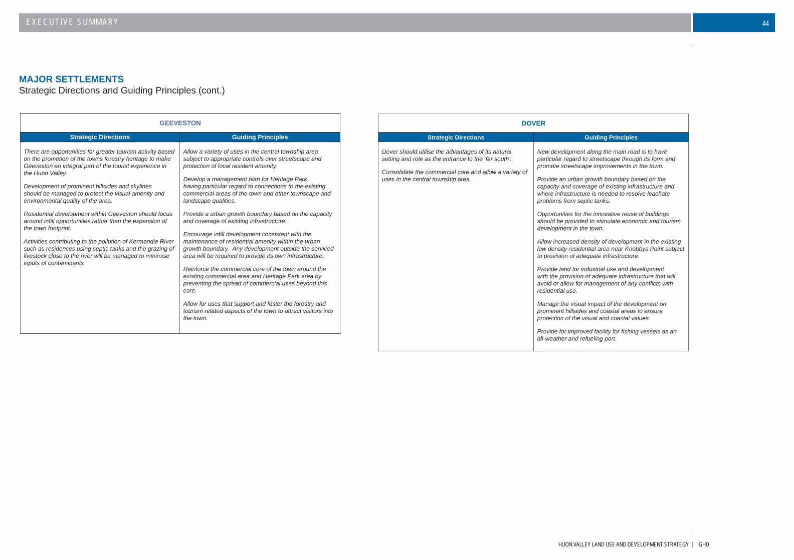
HUON VALLEY LAND USE AND DEVELOPMENT STRATEGY | GHD
EXECUTIVE SUMMARY 44
MAJOR SETTLEMENTSStrategic Directions and Guiding Principles (cont.)
GEEVESTON
Strategic Directions Guiding Principles
There are opportunities for greater tourism activity based on the promotion of the towns forestry heritage to make Geeveston an integral part of the tourist experience in the Huon Valley.
Development of prominent hillsides and skylines should be managed to protect the visual amenity and environmental quality of the area.
Residential development within Geeveston should focus around infi ll opportunities rather than the expansion of the town footprint.
Activities contributing to the pollution of Kermandie River such as residences using septic tanks and the grazing of livestock close to the river will be managed to minimise inputs of contaminants
Allow a variety of uses in the central township area subject to appropriate controls over streetscape and protection of local resident amenity.
Develop a management plan for Heritage Park having particular regard to connections to the existing commercial areas of the town and other townscape and landscape qualities.
Provide a urban growth boundary based on the capacity and coverage of existing infrastructure.
Encourage infi ll development consistent with the maintenance of residential amenity within the urban growth boundary. Any development outside the serviced area will be required to provide its own infrastructure.
Reinforce the commercial core of the town around the existing commercial area and Heritage Park area by preventing the spread of commercial uses beyond this core.
Allow for uses that support and foster the forestry and tourism related aspects of the town to attract visitors into the town.
DOVER
Strategic Directions Guiding Principles
Dover should utilise the advantages of its natural setting and role as the entrance to the ‘far south’.
Consolidate the commercial core and allow a variety of uses in the central township area.
New development along the main road is to have particular regard to streetscape through its form and promote streetscape improvements in the town.
Provide an urban growth boundary based on the capacity and coverage of existing infrastructure and where infrastructure is needed to resolve leachate problems from septic tanks.
Opportunities for the innovative reuse of buildings should be provided to stimulate economic and tourism development in the town.
Allow increased density of development in the existing low density residential area near Knobbys Point subject to provision of adequate infrastructure.
Provide land for industrial use and development with the provision of adequate infrastructure that will avoid or allow for management of any confl icts with residential use.
Manage the visual impact of the development on prominent hillsides and coastal areas to ensure protection of the visual and coastal values.
Provide for improved facility for fi shing vessels as an all-weather and refueling port.

GHD | HUON VALLEY LAND USE AND DEVELOPMENT STRATEGY
EXECUTIVE SUMMARY45
MINOR SETTLEMENTSStrategic Directions and Guiding Principles
PORT HUON
Strategic Directions Guiding Principles
The Port Huon wharf is a key asset that has the potential to be redeveloped for a variety of tourism, commercial and maritime purposes.
Future use of the Whale Point industrial area will be restricted by the lack of connection to reticulated sewerage and water systems.
The precinct containing the hotel, motel, marina, sports centre and parking areas is an important tourist and visitor hub and should be enhanced through landscaping and further appropriate development.
Promote commercial and tourist uses at Port Huon Wharf.
Provide protection of the Port Huon wharf from use or development on surrounding sites that could limit the site’s potential for commercial redevelopment and provide fl exibility for a variety of uses on the site.
Encourage marine related commercial activities and industries on and close to the existing port infrastructure subject to provision of adequate infrastructure.
Consolidate commercial and tourist use and development around the existing hotel, motel and sports centre.
Provide for some limited residential expansion in accordance with existing available or planned services.
Allow for aquaculture related industry and other uses that are not necessarily dependant upon Council’s sewer and water infrastructure at Whale Point within an identifi ed zone subject to environmental protection measures and the maintenance of vegetation buffers to screen the area from remote views across the bay.
GLEN HUON/JUDBURY
Strategic Directions Guiding Principles
Retain the rural character of the district by discouraging inappropriate use or development that would detract from the character of the district or result in confl icts with established use or development.
Allow for some infi ll development within existing settlement boundaries subject to adequate methods of effl uent disposal and environmental protection measures.
Identify designated rural living areas where existing rural residential development has occurred to such an extent that it dominates local land use and where environmental values will not be compromised,
Require use of Aerated Wastewater Treatment Systems only where on site treatment is proposed.
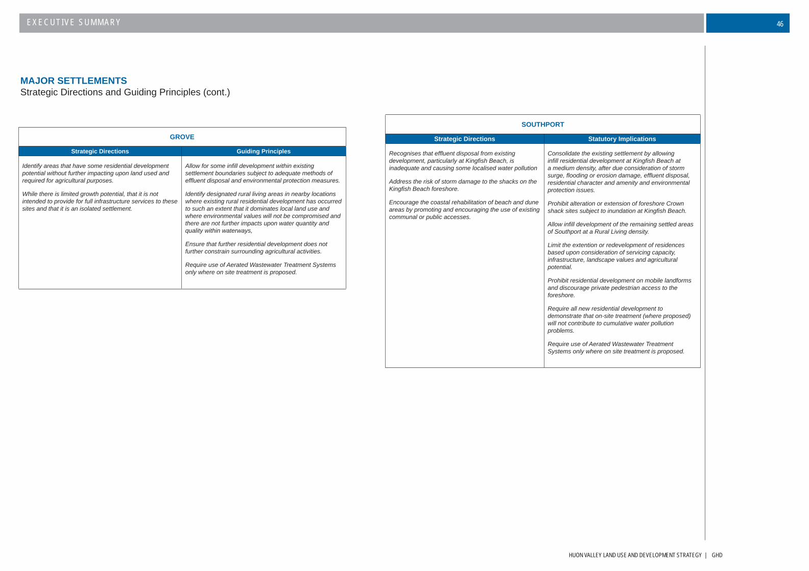
HUON VALLEY LAND USE AND DEVELOPMENT STRATEGY | GHD
EXECUTIVE SUMMARY 46
SOUTHPORT
Strategic Directions Statutory Implications
Recognises that effl uent disposal from existing development, particularly at Kingfi sh Beach, is inadequate and causing some localised water pollution
Address the risk of storm damage to the shacks on the Kingfi sh Beach foreshore.
Encourage the coastal rehabilitation of beach and dune areas by promoting and encouraging the use of existing communal or public accesses.
Consolidate the existing settlement by allowing infi ll residential development at Kingfi sh Beach at a medium density, after due consideration of storm surge, fl ooding or erosion damage, effl uent disposal, residential character and amenity and environmental protection issues.
Prohibit alteration or extension of foreshore Crown shack sites subject to inundation at Kingfi sh Beach.
Allow infi ll development of the remaining settled areas of Southport at a Rural Living density.
Limit the extention or redevelopment of residences based upon consideration of servicing capacity, infrastructure, landscape values and agricultural potential.
Prohibit residential development on mobile landforms and discourage private pedestrian access to the foreshore.
Require all new residential development to demonstrate that on-site treatment (where proposed) will not contribute to cumulative water pollution problems.
Require use of Aerated Wastewater Treatment Systems only where on site treatment is proposed.
GROVE
Strategic Directions Guiding Principles
Identify areas that have some residential development potential without further impacting upon land used and required for agricultural purposes.
While there is limited growth potential, that it is not intended to provide for full infrastructure services to these sites and that it is an isolated settlement.
Allow for some infi ll development within existing settlement boundaries subject to adequate methods of effl uent disposal and environmental protection measures.
Identify designated rural living areas in nearby locations where existing rural residential development has occurred to such an extent that it dominates local land use and where environmental values will not be compromised and there are not further impacts upon water quantity and quality within waterways,
Ensure that further residential development does not further constrain surrounding agricultural activities.
Require use of Aerated Wastewater Treatment Systems only where on site treatment is proposed.
MAJOR SETTLEMENTSStrategic Directions and Guiding Principles (cont.)
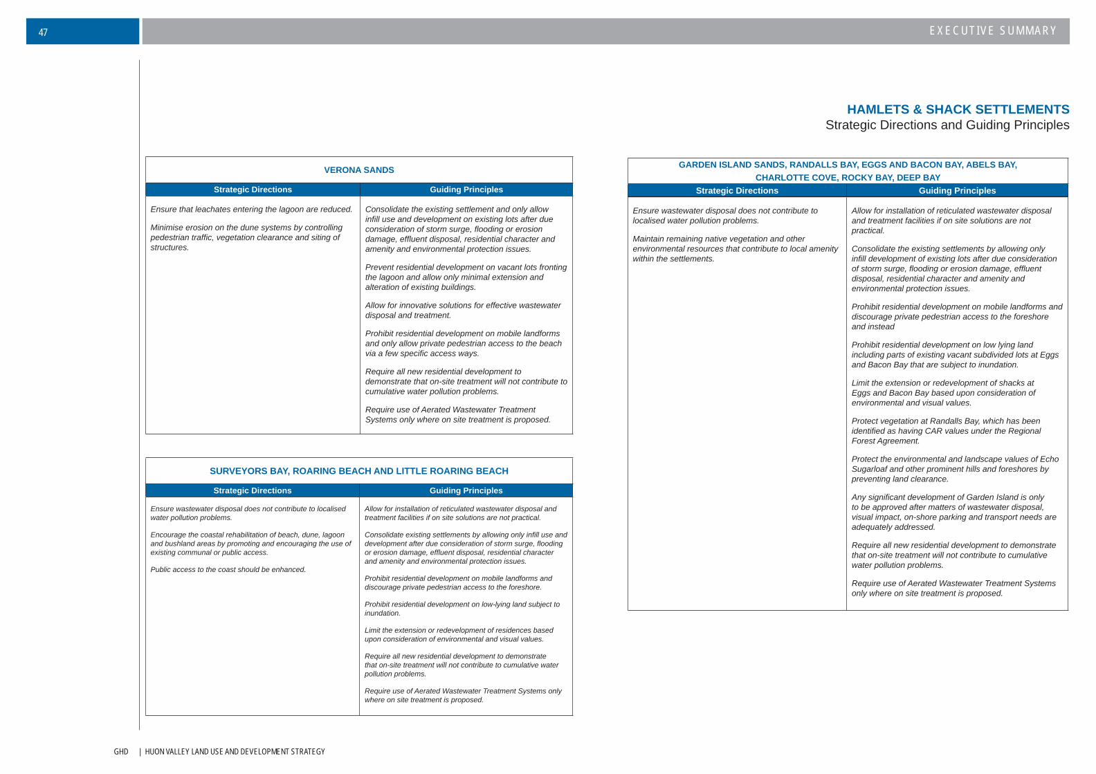
GHD | HUON VALLEY LAND USE AND DEVELOPMENT STRATEGY
EXECUTIVE SUMMARY47
HAMLETS & SHACK SETTLEMENTSStrategic Directions and Guiding Principles
VERONA SANDS
Strategic Directions Guiding Principles
Ensure that leachates entering the lagoon are reduced.
Minimise erosion on the dune systems by controlling pedestrian traffi c, vegetation clearance and siting of structures.
Consolidate the existing settlement and only allow infi ll use and development on existing lots after due consideration of storm surge, fl ooding or erosion damage, effl uent disposal, residential character and amenity and environmental protection issues.
Prevent residential development on vacant lots fronting the lagoon and allow only minimal extension and alteration of existing buildings.
Allow for innovative solutions for effective wastewater disposal and treatment.
Prohibit residential development on mobile landforms and only allow private pedestrian access to the beach via a few specifi c access ways.
Require all new residential development to demonstrate that on-site treatment will not contribute to cumulative water pollution problems.
Require use of Aerated Wastewater Treatment Systems only where on site treatment is proposed.
SURVEYORS BAY, ROARING BEACH AND LITTLE ROARING BEACH
Strategic Directions Guiding Principles
Ensure wastewater disposal does not contribute to localised water pollution problems.
Encourage the coastal rehabilitation of beach, dune, lagoon and bushland areas by promoting and encouraging the use of existing communal or public access.
Public access to the coast should be enhanced.
Allow for installation of reticulated wastewater disposal and treatment facilities if on site solutions are not practical.
Consolidate existing settlements by allowing only infi ll use and development after due consideration of storm surge, fl ooding or erosion damage, effl uent disposal, residential character and amenity and environmental protection issues.
Prohibit residential development on mobile landforms and discourage private pedestrian access to the foreshore.
Prohibit residential development on low-lying land subject to inundation.
Limit the extension or redevelopment of residences based upon consideration of environmental and visual values.
Require all new residential development to demonstrate that on-site treatment will not contribute to cumulative water pollution problems.
Require use of Aerated Wastewater Treatment Systems only where on site treatment is proposed.
GARDEN ISLAND SANDS, RANDALLS BAY, EGGS AND BACON BAY, ABELS BAY, CHARLOTTE COVE, ROCKY BAY, DEEP BAY
Strategic Directions Guiding Principles
Ensure wastewater disposal does not contribute to localised water pollution problems.
Maintain remaining native vegetation and other environmental resources that contribute to local amenity within the settlements.
Allow for installation of reticulated wastewater disposal and treatment facilities if on site solutions are not practical.
Consolidate the existing settlements by allowing only infi ll development of existing lots after due consideration of storm surge, fl ooding or erosion damage, effl uent disposal, residential character and amenity and environmental protection issues.
Prohibit residential development on mobile landforms and discourage private pedestrian access to the foreshore and instead
Prohibit residential development on low lying land including parts of existing vacant subdivided lots at Eggs and Bacon Bay that are subject to inundation.
Limit the extension or redevelopment of shacks at Eggs and Bacon Bay based upon consideration of environmental and visual values.
Protect vegetation at Randalls Bay, which has been identifi ed as having CAR values under the Regional Forest Agreement.
Protect the environmental and landscape values of Echo Sugarloaf and other prominent hills and foreshores by preventing land clearance.
Any signifi cant development of Garden Island is only to be approved after matters of wastewater disposal, visual impact, on-shore parking and transport needs are adequately addressed.
Require all new residential development to demonstrate that on-site treatment will not contribute to cumulative water pollution problems.
Require use of Aerated Wastewater Treatment Systems only where on site treatment is proposed.

HUON VALLEY LAND USE AND DEVELOPMENT STRATEGY | GHD
EXECUTIVE SUMMARY 48
MAJOR SETTLEMENTSSettlement Strategy Map
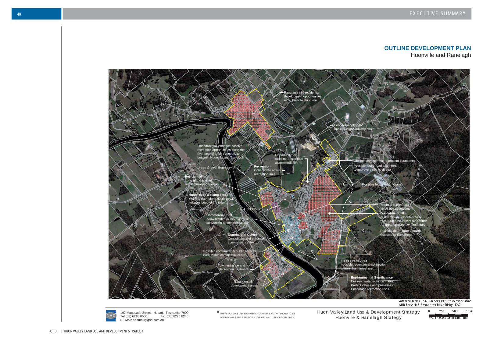
GHD | HUON VALLEY LAND USE AND DEVELOPMENT STRATEGY
EXECUTIVE SUMMARY49
Town entrance andintersection treatment
Infill residentialdevelopment areas
Environmental SignificanceEnvironmental significant area.Protect values and processes.Encourage recreation uses.
Urban Growth Boundary
Commercial CentreConsolidate and enhancecommercial centre
Residential infillResidential development to beencouraged on vacant land withinthe urban growth town boundary
Light Industry
RecreationConsolidate activerecreation area
Commercial infillAllow residential developmentconversion to commercial use
Huon River Walking TrackWalking path along riverside withlinkages beyond the town
ResidentialLong term servicedresidential opportunities
Flood Prone AreaPossible recreational connectionto town from foreshore
Possible community & public servicesnode within commercial centre
Ranelagh infill residentialdevelopment opportunitiesas 'suburb' to Huonville
Possible future road alignmentto improve traffic circulation
Long term option forbusiness/light industry park
Possible future urban growth
Potential commercial /mixed use development
Opportunity to enhance passiverecreation opportunities along theriver providing for connectivitybetween Huonville and Ranelagh
Opportunity fortourism / residentialaccommodation Confine development to present boundaries
Possible future urban growthadjacent to Sale Street
E - Mail: [email protected] (03) 6223 8246
162 Macquarie Street, Hobart, Tasmania, 7000Tel (03) 6210 0600
Huon Valley Land Use & Development StrategyHuonville & Ranelagh Strategy
*THESE OUTLINE DEVELOPMENT PLANS ARE NOT INTENDED TO BE
ZONING MAPS BUT ARE INDICATIVE OF LAND USE OPTIONS ONLY.
OUTLINE DEVELOPMENT PLANHuonville and Ranelagh
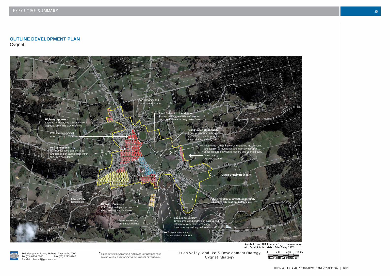
HUON VALLEY LAND USE AND DEVELOPMENT STRATEGY | GHD
EXECUTIVE SUMMARY 50
OUTLINE DEVELOPMENT PLANCygnet
Maintain existinglight industrial use
Highway BusinessEncourage well planned anddesigned highway business
Town entrance andintersection treatment
Low DensityResidential
Linkage to EstuaryCreate improved pedestrian access andinterpretative facilities at estuary.Incorporating walking trail to Martins Point
Urban Growth Boundary
Good qualityagricultural land
Land Subject to InundationProtect landscape value and ensurecapacity for area to carry water flows
Town entrance andintersection treatment
Highway ApproachImprove landscape quality and visualappearance of highway entrance
Residential InfillResidential development to beencouraged on vacant land withinthe town boundaries
Open Space OpportunityLong term opportunity forcreation of a public parkincorporating walking trail
Potential for urban development taking into accountland subject to inundation and necesity for openspace linkage between foreshore and sports ground
Future residential growth opportunitysubject to attenuation distances
Potential commercialmixed use development
E - Mail: [email protected] (03) 6223 8246
162 Macquarie Street, Hobart, Tasmania, 7000Tel (03) 6210 0600
Huon Valley Land Use & Development StrategyCygnet Strategy
*THESE OUTLINE DEVELOPMENT PLANS ARE NOT INTENDED TO BE
ZONING MAPS BUT ARE INDICATIVE OF LAND USE OPTIONS ONLY.

GHD | HUON VALLEY LAND USE AND DEVELOPMENT STRATEGY
EXECUTIVE SUMMARY51
OUTLINE DEVELOPMENT PLANFranklin
Environmental SignificanceEnvironmental significant area.Protect values and natural processesassociated with Egg Island
Urban Growth Boundary
Highway BusinessEncourage well planned anddesigned mixed use development
Recreation to enhance enjoyment of theforeshore incorporating walking trail
Protect Commercial CentreLimit linear commercial development
Riverfront DevelopmentDevelopment should be dependant on theriver and its siting should not negativelyimpact on the river foreshore
Town entrance
Integration of Built and Natural FormFranklin is a unique town with its locationbetween river and hill
Limit Residential DevelopmentEnsure all future development protects and enhanceslandscape values between the Huon River and the skyline asreviewed from both the Huon Highway and Channel Highway
Residential infillResidential development to beencouraged on vacant land withinthe town boundaries subject to roadaccess limitations
Retain Heritage CharacterNew use and development to conserve heritageelements and have regard to surrounding builtform particularly along the Huon Highway
Town entrance
Highway ApproachImprove landscape quality and visualappearance of highway entrance
Possible long termresidential development
Possible long termresidential development
Residential development subject toinfrastructure and road upgrade contributions,and minimisation of visual impacts
HUON
RIVER
Maintain public foreshore land
Improve boating access to foreshore
E - Mail: [email protected] (03) 6223 8246
162 Macquarie Street, Hobart, Tasmania, 7000Tel (03) 6210 0600
Huon Valley Land Use & Development StrategyFranklin Strategy
*THESE OUTLINE DEVELOPMENT PLANS ARE NOT INTENDED TO BE
ZONING MAPS BUT ARE INDICATIVE OF LAND USE OPTIONS ONLY.
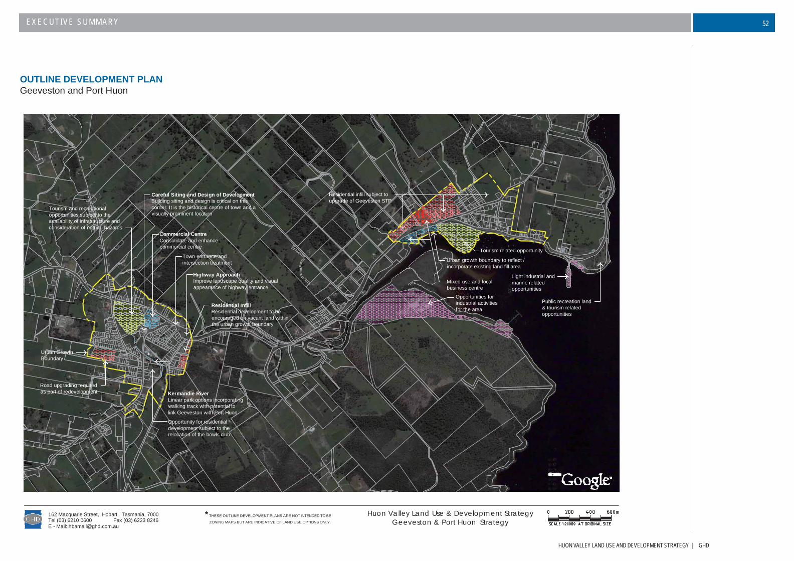
HUON VALLEY LAND USE AND DEVELOPMENT STRATEGY | GHD
EXECUTIVE SUMMARY 52
Town entrance andintersection treatment
Residential InfillResidential development to beencouraged on vacant land withinthe urban growth boundary
Highway ApproachImprove landscape quality and visualappearance of highway entrance
Commercial CentreConsolidate and enhancecommercial centre
Careful Siting and Design of DevelopmentBuilding siting and design is critical on thiscorner. It is the historical centre of town and avisually prominent location
Urban GrowthBoundary
Road upgrading requiredas part of redevelopment
Tourism and recreationalopportunities subject to theavailability of infrastructure andconsideration of natural hazards
Kermandie RiverLinear park options incorporatingwalking track with potential tolink Geeveston with Port Huon
Tourism related opportunity
Mixed use and localbusiness centre
Light industrial andmarine relatedopportunities
Opportunities forindustrial activitiesfor the area
Residential infill subject toupgrade of Geeveston STP
Public recreation land& tourism relatedopportunities
Opportunity for residentialdevelopment subject to therelocation of the bowls club
Urban growth boundary to reflect /incorporate existing land fill area
E - Mail: [email protected] (03) 6223 8246
162 Macquarie Street, Hobart, Tasmania, 7000Tel (03) 6210 0600
Huon Valley Land Use & Development StrategyGeeveston & Port Huon Strategy
*THESE OUTLINE DEVELOPMENT PLANS ARE NOT INTENDED TO BE
ZONING MAPS BUT ARE INDICATIVE OF LAND USE OPTIONS ONLY.
OUTLINE DEVELOPMENT PLANGeeveston and Port Huon

GHD | HUON VALLEY LAND USE AND DEVELOPMENT STRATEGY
EXECUTIVE SUMMARY53
OUTLINE DEVELOPMENT PLANDover
Prominent HillsideLandscape value of hillsideto be protected
Town entrance andintersection treatment
Promote ConnectionPromote connection betweencommercial areas and foreshorewalking track
Protect Commercial CentreConsolidate commercialdevelopment area
Orchard AreaMaintain separation betweenDover and Harveytown
Limit Residential DevelopmentRemove current residential zoning to reduceover supply and inappropriate location forresidential development
Land partially serviced with infrastructure. Lower densityresidential with limited infill opportunities subject tosatisfactory waste disposal.
Possible future development subject to a new seweragetreatment plant and upgrade of road, electricity, water andtelecommunications infrastructure.
Residential InfillResidential development subject to environmentalmanagement and infrastructure
ConsolidateRestrict further low density residentialdevelopment to consolidate town
Prominent HillsideLandscape value of hillsideto be protected
Key Vacant SiteProminent vacant site shouldbe used for town feature
Urban Growth Boundary
Opportunity to enhanceactive and passive recreation
Harvey Town
Opportunity to enhance the foreshore forrecreational opportunities
Opportunity to link beaches with awalking track along foreshore
Potential tourismaccomodation opportunities
Mixed use
Improve amenity of open space
Opportunity to link beaches with awalking track along foreshore
Improve facilities for commercial fishing
Opportunity for foreshore & marine related activity. Enhancingexperience of the 'Esperance' as a tourism destination
E - Mail: [email protected] (03) 6223 8246
162 Macquarie Street, Hobart, Tasmania, 7000Tel (03) 6210 0600
Huon Valley Land Use & Development StrategyDover Strategy
Map data reproduced withthe permission of TASMAP
DEPARTMENT ofPRIMARY INDUSTRIES,
WATER and ENVIRONMENT
*THESE OUTLINE DEVELOPMENT PLANS ARE NOT INTENDED TO BE
ZONING MAPS BUT ARE INDICATIVE OF LAND USE OPTIONS ONLY.


GHD | HUON VALLEY LAND USE AND DEVELOPMENT STRATEGY
EXECUTIVE SUMMARY55
GHD Pty Ltd ABN 39 008 488 373
162 Macquarie Street Hobart 7000 GPO Box 667 Hobart 7001
T: 03 6210 0600 F: 03 6223 8246 E: [email protected]
© GHD Pty Ltd 2006
This document is and shall remain the property of GHD Pty Ltd. The document may only be used for the purpose of assessing our offer of services and for inclusion in documentation for the engagement of GHD Pty Ltd. Unauthorised use of this document in any
form whatsoever is prohibited.
Document Status
Rev No. AuthorReviewer Approved for Issue
Name Signature Name Signature Date
DRAFT 1 VARIOUS F.READ FER* A.BROWNLIE ABB* 20.01.2006
DRAFT 2 E. RILEY A.BROWNLIE ABB* F.READ* FER* 12.12.2006
DRAFT FOR PUBLIC CONSULTATION E. RILEY A.BROWNLIE ABB* F. READ* FER* 28.06.2007
FINAL E. RILEY A.BROWNLIE ABB* F. READ* FER* 12.09.2007
ENDORSED E. RILEY A. BROWNLIE ABB* F. READ FER* 31.10.2007
*signature on fi le