Embed Size (px)
Citation preview
Humanitarian Demining - UAV-Based Detection of Land Mines
Reinhard GOTTWALD and Nando DOCCI, Switzerland
Winfried MAYER, Germany
Key words: UAV / UAS, flight planning, DTM, SAR / GPR, mine action / demining,
technical & non technical survey
SUMMARY
The humanitarian clearance of land mines is still a huge challenge:
- According to UN requirements at least 99.6% of all mines must be cleared up to a
depth of 13 cm,
- There are different types and sizes of mines (metal, minimum metal, non-metal)
- Mines were placed in different environments (city, jungle, desert) regularly or
irregularly and can be redistributed by erosion and surface movements.
In 2015 a feasibility study [Gottwald et al, 2015] proved the possibilities of a UAV-based
mine detection system for the automatic detection and localization of landmines. Since early
2016, in a cooperation of three Swiss and German Universities, a UAV-based system for mine
detection has been in development. This system will be used in the process of land release (a
very important part of mine action). The system consists simply of a 5kg payload drone, a
low-cost RTK-GNSS system, cameras for a photogrammetric production of a DTM,
microwave sensors for mine detection and an anti-collision system. One of the key problems
is the required high position- and orientation-accuracy of the drone to operate the microwave
mine detection sensors (SAR / GPR) properly. The whole system will be designed for easy
use by minimally trained operators.
This paper focuses on the current state of the project and on future perspectives and
challenges. This project is supported by the Geneva International Centre for Humanitarian
Demining (GIHCD) and is financed by the Swiss 'Foundation Urs Endress',
Arlesheim/Switzerland.
Zusammenfassung
Die humanitäre Räumung von Landminen stellt auch heute noch vor eine grosse
Herausforderung dar:
- Nach UN-Anforderungen müssen mindestens 99,6% aller Minen bis zu einer Tiefe
von 13 cm gefunden und beseitigt sein,
- Es gibt verschiedene Typen und Grössen von Minen (Metall, Mindestmetall,
Nichtmetall)
- Minen wurden in verschiedensten Umgebungen (Ortschaften, Dschungel, Wüste)
platziert und können durch Erosion und Oberflächenbewegungen verschoben werden.
Humanitarian Demining - UAV-Based Detection of Land Mines (8531)
Reinhard Gottwald (Switzerland), Winfried Mayer (Germany) and Nando Docci (Switzerland)
FIG Working Week 2017
Surveying the world of tomorrow - From digitalisation to augmented reality
Helsinki, Finland, May 29–June 2, 2017
Eine Machbarkeitsstudie [Gottwald et al., 2015] zeigte die Möglichkeiten eines UAV-
basierten Minen-Detektions-Systems zur automatischen Erkennung und Lokalisierung von
Landminen auf. Seit Anfang 2016 wird in Kooperation von drei Schweizer und Deutschen
Hochschulen ein UAV-basiertes System zur Detektion von Landminen entwickelt. Dieses
System soll zunächst im Prozess des ‚Landrelease‘ (ein sehr wichtiger Teil der ‚Mine Action‘)
eingesetzt werden. Das System besteht im Wesentlichen aus einer Drohne mit ca. 5 kg
Nutzlast, einem lowcost RTK-GNSS-System, Kameras für die photogrammetrische
Herstellung eines DTM, Mikrowellensensoren zur Minenerkennung und einem
Antikollisionssystem. Eines der Hauptprobleme ist die geforderte hohe Positions- und
Orientierungsgenauigkeit der Drohne, um die Mikrowellensensoren (SAR / GPR) richtig
betreiben zu können. Das gesamte System wird für eine einfache Bedienung durch minimal
geschultes Bedienpersonal ausgelegt.
Dieser Artikel fokussiert sich auf den aktuellen Projektstand und auf Perspektiven und
Herausforderungen. Unterstützt wird dieses Projekt vom Geneva International Centre for
Humanitarian Demining (GIHCD) in Genf. Die Finanzierung erfolgt über die Stiftung Urs
Endress, Arlesheim / Schweiz.
Humanitarian Demining - UAV-Based Detection of Land Mines (8531)
Reinhard Gottwald (Switzerland), Winfried Mayer (Germany) and Nando Docci (Switzerland)
FIG Working Week 2017
Surveying the world of tomorrow - From digitalisation to augmented reality
Helsinki, Finland, May 29–June 2, 2017
Humanitarian Demining - UAV-Based Detection of Land Mines
Reinhard GOTTWALD and Nando DOCCI, Switzerland
Winfried MAYER, Germany
1. INTRODUCTION
1.1 General introduction and motivation
Every day approximately 10 people around the world lose their lives or their limbs to a
landmine or through explosive remnants of war (ERW). This means that about 4,000 people
are hurt or killed worldwide every year. Approximately 60 countries around the world are
contaminated by landmines and / or ERWs. Landmines / ERW prevent the productive use of
the land (eg agriculture). They generate a lasting sense of insecurity long after the end of war
conflicts, delay peace processes and hinder the development of the affected countries for
many years.
Nobody knows exactly how many mines have been laid in the ground worldwide (in the
literature one finds estimates of 60 to 100 million). The actual number is less important than
its impact: a few mines or the mere suspicion of their presence can make a piece of land
unusable. An important feature of the antipersonnel-mines is that they are designed to maim
rather than kill a human. In the meantime, antipersonnel mines are also being used against the
civilian population to terrorize communities, to prevent access to agricultural land and to
restrict freedom of movement.
The average cost of locating and clearing landmines is US$ 2.25 (US$ 0.6 - 8.75) / m2
[http://www.mineactionreview.org]. Further to this, the average area searched to find one
mine is approximately 2500 m2 (i.e. US $ 5625 per mine found and cleared.).
At the end of 2014, the idea of using UAV/UAS with an appropriate mine detecting sensor
system was discussed at the FHNW. A study project was initiated (financed by the FHNW
Foundation http://www.stiftungfhnw.ch) to check the feasibility of these ideas. The study
project was finalized in July 2015 and the results summarized in an internal study report
(Gottwald et.al 2015). Following this study, it was decided to set up an R&D project (see 2.2)
with the aim to develop an operational system by the end of 2018.
1.2 Mine action standards
According to the current Mine Action Standards [UNMAS, 2016], the mine search and
removal process has three stages:
3.159. land release (2013) - in the context of mine action, the term describes the process of
applying all reasonable efforts to identify, define, and remove mines or the suspicion of
mines / ERW through
- Non-technical survey (NTS),
- Technical survey (TS)
Humanitarian Demining - UAV-Based Detection of Land Mines (8531)
Reinhard Gottwald (Switzerland), Winfried Mayer (Germany) and Nando Docci (Switzerland)
FIG Working Week 2017
Surveying the world of tomorrow - From digitalisation to augmented reality
Helsinki, Finland, May 29–June 2, 2017

- and / or clearance.
NTS is defined in [IMAS 04.10, 2014] as " the collection and analysis of data, without the use
of technical interventions, about the presence, type, distribution and surrounding environment
of mine/ERW contamination, …" Examples for NTS are mapped minefields from known
battlefields (direct combat areas, strategic bridges and roads, …), reports from residents, or
accidents. TS is defined in [IMAS 04.10, 2014] as " the collection and analysis of data, using
appropriate technical interventions, about the presence, type, distribution and surrounding
environment of mine/ERW contamination, …" . Examples of TS are the classical deminers
with needles or metal detectors for finding the mines or protected demining machines with a
rolling chain in front to deploy the mines.
The process starts with NTS. For example, there may exist mine maps of an area or visible
mines seen by residents. The area is to declare the suspected area, which could be very large
(e.g. 3 km x 1 km). The next step is to localize the contaminated areas inside the suspected
area. For example, demining machines (TS) could do this. The demining machines drive in
patterns through the suspected areas and locate specific areas. After reducing the large
suspected area into smaller contaminated areas (e.g. 200 x 100 m), human deminers can start
to clear the area. After that, the area is released to the residents (land-release).
Fig. 1: Overview Mine action standards that shows the different sizes of the areas [N. Docci, 2017]
2. THE FIND-MINE PROJECT
2.1 General Process
The main target of FindMine is to reduce the time-consuming search for confirmed areas
(TS). The currently used demining machines, which are expensive to buy and use, can clean
an area of about 1000 m2 per hour. In comparison, a human deminer can clean 35 m
2 per hour
Humanitarian Demining - UAV-Based Detection of Land Mines (8531)
Reinhard Gottwald (Switzerland), Winfried Mayer (Germany) and Nando Docci (Switzerland)
FIG Working Week 2017
Surveying the world of tomorrow - From digitalisation to augmented reality
Helsinki, Finland, May 29–June 2, 2017

[FINDMINE1, 2016]. A UAV/UAS-based system is much cheaper and is able to check about
10'000 - 20'000 m2 per hour.
Process chain:
- generate an overview of the suspected area including orthophoto-mosaic and surface
models (UAS, RGB camera and additional sensors)
- flight planning for the radar flight (challenge - relative position accuracy 2mm, max.
flight height over ground 2 m, depression angle for GPR 20-30°)
- Changing sensors on the UAS - GPR-flight (on board data collection)
- Post processing (fusion of GNSS and GPR data), update of the GIS database
- Generation of handprints and/or data exchange to the human deminers and the national
demining database (IMSMA GIS).
Fig. 2: Process-chain FindMine Project [N. Docci, 2017]
2.2 Project-Team & Partners
Project-Team:
- University of Applied Sciences and Arts Northwestern Switzerland (FHNW) - School
of Architecture, Civil Engineering and Geomatics - responsible for the UAS/UAV,
GIS/DTM/mapping and documentation
- University of Applied Sciences and Arts Northwestern Switzerland (FHNW) - School
of Engineering - responsible for the overall system integration
- University Ulm and the University of Applied Sciences Ulm - responsible for
SAR/GPR, antenna, detection technology and radar processing
Partner:
Humanitarian Demining - UAV-Based Detection of Land Mines (8531)
Reinhard Gottwald (Switzerland), Winfried Mayer (Germany) and Nando Docci (Switzerland)
FIG Working Week 2017
Surveying the world of tomorrow - From digitalisation to augmented reality
Helsinki, Finland, May 29–June 2, 2017
- Technical and operational support by GICHD (Geneva International Centre for
Humanitarian Demining) and FSD (Fondation Suisse de Deminage)
- The project is financed by the "Foundation Urs Endress", Arlesheim/Switzerland.
3. BASIC SYSTEM
3.1 UAS / RTK GNSS
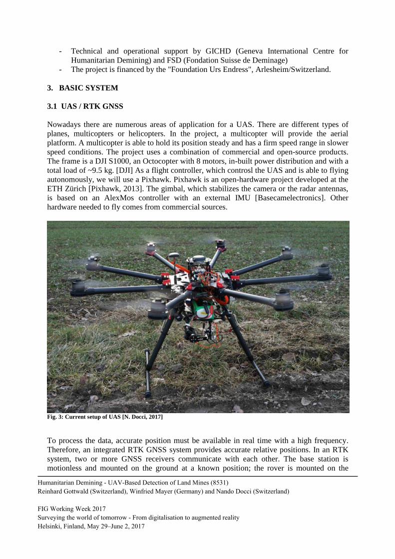
Nowadays there are numerous areas of application for a UAS. There are different types of
planes, multicopters or helicopters. In the project, a multicopter will provide the aerial
platform. A multicopter is able to hold its position steady and has a firm speed range in slower
speed conditions. The project uses a combination of commercial and open-source products.
The frame is a DJI S1000, an Octocopter with 8 motors, in-built power distribution and with a
total load of ~9.5 kg. [DJI] As a flight controller, which controsl the UAS and is able to flying
autonomously, we will use a Pixhawk. Pixhawk is an open-hardware project developed at the
ETH Zürich [Pixhawk, 2013]. The gimbal, which stabilizes the camera or the radar antennas,
is based on an AlexMos controller with an external IMU [Basecamelectronics]. Other
hardware needed to fly comes from commercial sources.
Fig. 3: Current setup of UAS [N. Docci, 2017]
To process the data, accurate position must be available in real time with a high frequency.
Therefore, an integrated RTK GNSS system provides accurate relative positions. In an RTK
system, two or more GNSS receivers communicate with each other. The base station is
motionless and mounted on the ground at a known position; the rover is mounted on the
Humanitarian Demining - UAV-Based Detection of Land Mines (8531)
Reinhard Gottwald (Switzerland), Winfried Mayer (Germany) and Nando Docci (Switzerland)
FIG Working Week 2017
Surveying the world of tomorrow - From digitalisation to augmented reality
Helsinki, Finland, May 29–June 2, 2017
mobile system [Drotek, 2016]. The base station sends its position to the rover station, after
which the difference between the carrier wave signals is measured and a position is
calculated.
Currently we are using a French product, which includes a U-Blox-M8T chip. The on-board
mounted Intel Edison processor calculates the solution by using the open-source software
RTKLIB [Drotek, 2016]. To use this UAS around the world in places without internet GSM
connectivity, the position data from the base station is transmitted via radio.
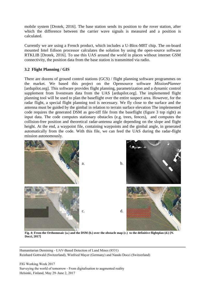
3.2 Flight Planning / GIS
There are dozens of ground control stations (GCS) / flight planning software programmes on
the market. We based this project on the Opensource software MissionPlanner
[ardupilot.org]. This software provides flight planning, parametrization and a dynamic control
supplement from livestream data from the UAS [ardupilot.org]. The implemented flight
planning tool will be used to plan the baseflight over the entire suspect area. However, for the
radar flight, a special flight planning tool is necessary. We fly close to the surface and the
antenna must be guided by the gimbal in relation to terrain surface elevation The implemented
code requires the generated DSM as geo-tiff file from the baseflight (figure 3 top right) as
input data. The code computes stationary obstacles (e.g. trees, fences), and computes the
collision-free position and theoretical radar-antenna angle depending on the slope and flight
height. At the end, a waypoint file, containing waypoints and the gimbal angle, in generated
automatically from the code. With this file, we can feed the UAS during the radar-flight
mission autonomously.
Fig. 4: From the Orthomosaic (a.) and the DSM (b.) over the obstacle map (c.) to the definitive flightplan (d.) [N.
Docci, 2017]
a. b.
c. d.
Humanitarian Demining - UAV-Based Detection of Land Mines (8531)
Reinhard Gottwald (Switzerland), Winfried Mayer (Germany) and Nando Docci (Switzerland)
FIG Working Week 2017
Surveying the world of tomorrow - From digitalisation to augmented reality
Helsinki, Finland, May 29–June 2, 2017
The GIS is an important part during the whole process, especially for spreading the collected
data. For this project, QuantumGIS (QGIS) is used. QGIS is "cross-platform free and open-
source desktop geographic information system application that provides data viewing, editing
and analyses" [Wikipedia, 2017]. In the first step of the process, QGIS and existing maps are
used to determine the shape and size of the suspected area. The outputs from the base flight
are the basis for further analysis. After the radar flight is processed, possible mine locations
are illustrated. Exporting the data into different datatypes or accessing a national database to
share the data is the most common use of the entire demining process.
4. SENSORS
4.1 Synthetic Aperture Ground Penetrating Radar
Ground penetrating radar (GPR) has been used for more than 20 years to detect buried objects
[Daniels 2007]. As the detection possibilities of radar are not limited to metal objects, it has
become a promising approach for finding modern plastic landmines with minimum metal
contents. Presently most GPR sensors for mine detection operate very close to the surface
often in combination with metal detectors. There are handheld single antenna versions
[Daniels 2006] and vehicular-based array systems [GICHD 2006]. With these systems the
safety and efficiency of clearance actions can be supported by the radar principal. But they are
not useful for technical surveys of large suspected hazardous areas. For these areas, a
combination of the radar principle with an UAV is very promising.
Radar allows for remote detection. Electromagnetic waves, however, penetrate the ground
only at low frequencies. In [Frizsche 2001, Fischer 2003], microwave frequencies between
0.5GHz and 5GHz are proposed for the detection of landmines to a maximum depth of 20cm.
For the detection of mines, a minimum ground resolution in the range of the object diameter is
necessary. Antenna structures for focusing microwaves from a flying UAV to achieve ground
resolution in the range of 0.2m would need apertures of several meters, even if the altitude
above ground Hz was less than 5m. Such apertures would greatly extend the payloads and
dimensions of UAV platforms.
The synthetic aperture radar (SAR) principle [Mensa 1991] solves this problem by combining
the necessary aperture from numerous measurements coherently recorded along a properly
defined and typically linear flight path. The arrangement of an SAR system is depicted in
Figure 5.
Humanitarian Demining - UAV-Based Detection of Land Mines (8531)
Reinhard Gottwald (Switzerland), Winfried Mayer (Germany) and Nando Docci (Switzerland)
FIG Working Week 2017
Surveying the world of tomorrow - From digitalisation to augmented reality
Helsinki, Finland, May 29–June 2, 2017
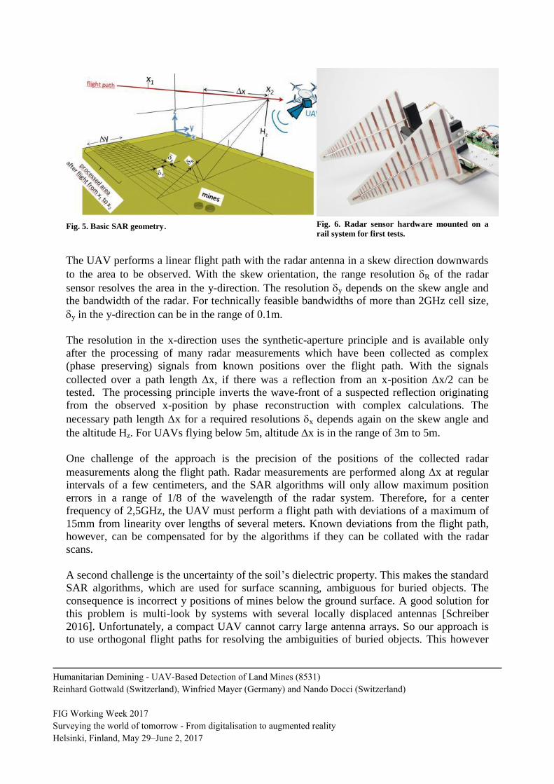
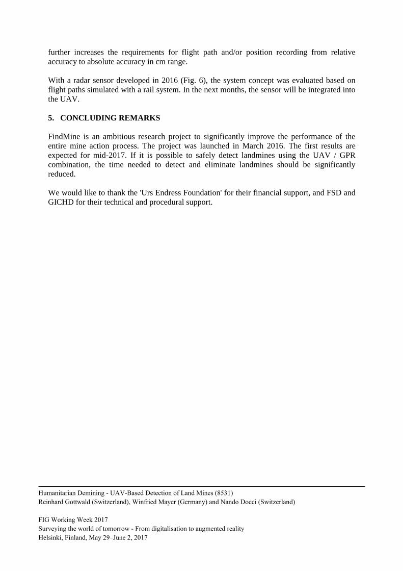
Fig. 5. Basic SAR geometry. Fig. 6. Radar sensor hardware mounted on a
rail system for first tests.
The UAV performs a linear flight path with the radar antenna in a skew direction downwards
to the area to be observed. With the skew orientation, the range resolution R of the radar
sensor resolves the area in the y-direction. The resolution y depends on the skew angle and
the bandwidth of the radar. For technically feasible bandwidths of more than 2GHz cell size,
y in the y-direction can be in the range of 0.1m.
The resolution in the x-direction uses the synthetic-aperture principle and is available only
after the processing of many radar measurements which have been collected as complex
(phase preserving) signals from known positions over the flight path. With the signals
collected over a path length x, if there was a reflection from an x-position x/2 can be
tested. The processing principle inverts the wave-front of a suspected reflection originating
from the observed x-position by phase reconstruction with complex calculations. The
necessary path length x for a required resolutions x depends again on the skew angle and
the altitude Hz. For UAVs flying below 5m, altitude x is in the range of 3m to 5m.
One challenge of the approach is the precision of the positions of the collected radar
measurements along the flight path. Radar measurements are performed along x at regular
intervals of a few centimeters, and the SAR algorithms will only allow maximum position
errors in a range of 1/8 of the wavelength of the radar system. Therefore, for a center
frequency of 2,5GHz, the UAV must perform a flight path with deviations of a maximum of
15mm from linearity over lengths of several meters. Known deviations from the flight path,
however, can be compensated for by the algorithms if they can be collated with the radar
scans.
A second challenge is the uncertainty of the soil’s dielectric property. This makes the standard
SAR algorithms, which are used for surface scanning, ambiguous for buried objects. The
consequence is incorrect y positions of mines below the ground surface. A good solution for
this problem is multi-look by systems with several locally displaced antennas [Schreiber
2016]. Unfortunately, a compact UAV cannot carry large antenna arrays. So our approach is
to use orthogonal flight paths for resolving the ambiguities of buried objects. This however
Humanitarian Demining - UAV-Based Detection of Land Mines (8531)
Reinhard Gottwald (Switzerland), Winfried Mayer (Germany) and Nando Docci (Switzerland)
FIG Working Week 2017
Surveying the world of tomorrow - From digitalisation to augmented reality
Helsinki, Finland, May 29–June 2, 2017
further increases the requirements for flight path and/or position recording from relative
accuracy to absolute accuracy in cm range.
With a radar sensor developed in 2016 (Fig. 6), the system concept was evaluated based on
flight paths simulated with a rail system. In the next months, the sensor will be integrated into
the UAV.
5. CONCLUDING REMARKS
FindMine is an ambitious research project to significantly improve the performance of the
entire mine action process. The project was launched in March 2016. The first results are
expected for mid-2017. If it is possible to safely detect landmines using the UAV / GPR
combination, the time needed to detect and eliminate landmines should be significantly
reduced.
We would like to thank the 'Urs Endress Foundation' for their financial support, and FSD and
GICHD for their technical and procedural support.
Humanitarian Demining - UAV-Based Detection of Land Mines (8531)
Reinhard Gottwald (Switzerland), Winfried Mayer (Germany) and Nando Docci (Switzerland)
FIG Working Week 2017
Surveying the world of tomorrow - From digitalisation to augmented reality
Helsinki, Finland, May 29–June 2, 2017
REFERENCES
ARDUPILOT DEV TEAM. Ardupilot overview. Accessed 16.02.2017; http://ardupilot.org/
BASECAMELECTRONICS. Accessed 16.02.2017; https://www.basecamelectronics.com/
DANIELS, D., & CURTIS, P. (2006). MINEHOUND trials in Bosnia, Angola and Cambodia.
Proceedings of the SPIE Defense and Security Conference. 17–23 April, Orlando, USA.
DANIELS, D. (2007). Ground Penetrating Radar. 2nd Edition ed. (IET, Ed.)
DJI (2017): Spreading Wings S1000, Specifications. Accessed 16.02.2017;
https://www.dji.com/de/spreading-wings-s1000/spec
ENDRESS FOUNDATION (2016): FINDMINE1. unpublished
FISCHER, C. (2003). Multistatisches Radar zur Lokalisierung von Objekten im Boden.
Foschungsbericht des IHE der Universität Karlsruhe, 39.
FRITZSCHE, M. (2001). Anwendungen von Verfahren der Mustererkennung zur Detektion
von Landminen mit Georadaren. Dissertation, Universität Karlsruhe.
GICHD. (2006). Guidebook on Detection Technologies and Systems for Humanitarian
Demining. Geneva International Centre for Humanitarian Demining;
https://www.gichd.org/resources/publications/detail/publication/guidebook-on-detection-
technologies-and-systems-for-humanitarian-demining/#.WKrCUHo3kTk
GOTTWALD, R. LOEPFE, M. MAYER, W. MATTI, E (2015): FindMine: UAV-basierte
Detektion von Landminen - Machbarkeitsstudie. unpublished
MENSA D. L. (1991). High Resolution Radar Cross-Section Imaging, Norwood, Artech
House.
MINEACTIONREVIEW. Clearing the Mines 2015. Accessed 10.02.2017;
http://www.mineaction-review.org/
OBORNE, M. Mission Planner Overview. Accessed 16.02.2017;
http://ardupilot.org/planner/docs/mission-planner-overview.html
PERIN, J. (2016): SMARTNAV RTK. [6. August 2017]; https://drotek.com/en/smartnav-rtk-
documentation/
PIXHAWK. Pixhawk. Accessed 16.02.2017; https://pixhawk.org/
Humanitarian Demining - UAV-Based Detection of Land Mines (8531)
Reinhard Gottwald (Switzerland), Winfried Mayer (Germany) and Nando Docci (Switzerland)
FIG Working Week 2017
Surveying the world of tomorrow - From digitalisation to augmented reality
Helsinki, Finland, May 29–June 2, 2017
SCHREIBER E., PEICHL. M., et. al. (2016). Challenges for operational use of ground-based
high-resolution SAR for landmines and UXO detection. Proceedings of the 11th
European
Conference on Synthetic Aperture Radar (EUSAR), pp. 834 - 837.
UNITED NATIONS MINE ACTION SERVICES (UNMAS) (2017): Mine Action Standards.
Accessed 16.02.2017; http://www.mineactionstandards.org/standards/international-mine-
action-standards-imas/imas-in-english/
UNITED NATIONS MINE ACTION SERVICES (UNMAS) (2014): IMAS 04.10 - Glossary
of mine action terms, definitions and abbreviations. 2nd
Edition, 1. January 2003, Amendment
7, August 2014
WIKIPEDIA (2016). QGIS. [24.02.2017]; https://en.wikipedia.org/wiki/QGIS
BIOGRAPHICAL NOTES
Reinhard Gottwald is professor for geodetic metrology and dean of the FHNW Bachelor
program in Geomatics Engineering. He received his diploma in geodesy at the University of
Bonn, Germany, in 1975 and his 'Vermessungsassessor' in 1978. After 3 years of practical
work at a publicly appointed surveyors’ office, he returned to university as a research
assistant. He received his PhD from the RWTH Aachen University in 1984. After 8 years in
industry (project management, R&D management), he was appointed professor at the
University of Applied Sciences and Arts Northwestern Switzerland (FHNW). He is a member
of the Swiss Geodetic Commission and of several other national and international
organizations. He is responsible for the FindMine project coordination
Winfried Mayer is senior expert for radar technology at Endress+Hauser GmbH + Co. KG in
Maulburg, Germany. He received a Dipl.-Ing. (BA) degree in communication technology
from the Berufsakademie Ravensburg in 1994 and the Dr.-Ing. title from Ulm University in
2008. From 1994 to 2001, he was with EADS Germany Microwave Factory R&D. From 2002
to 2007, he did research on imaging radar sensors and digital beam-forming at the Institute of
Microwave Techniques of Ulm University. Since 2007, he has been with Endress+Hauser and
responsible for predevelopment and technology in radar. In the FindMine project, he
coordinates the radar sensor activities.
Nando Docci is a research assistant with special skills in UAVs. He finished his
apprenticeship as a surveyor in 2009. After a year of military service, he decided to do a BSc
in Geomatics. He received his degree after part-time studies in 2015. Because of his interest
and experience in constructing and flying UAVs, he became part of the FindMine team. He is
responsible for the entire UAS and GIS parts of the project.
Humanitarian Demining - UAV-Based Detection of Land Mines (8531)
Reinhard Gottwald (Switzerland), Winfried Mayer (Germany) and Nando Docci (Switzerland)
FIG Working Week 2017
Surveying the world of tomorrow - From digitalisation to augmented reality
Helsinki, Finland, May 29–June 2, 2017
CONTACTS
Prof. Dr. Reinhard Gottwald
University of Applied Sciences and Arts Northwestern Switzerland School of Architecture,
Civil Engineering and Geomatics, Institute of Geomatic Engineering
Gründenstrasse 40 CH-4132 Muttenz SWITZERLAND
Tel. + 41 61 4674 339
Fax + 41 61 4674 460
Email: [email protected]
Web site: www.fhnw.ch/ivgi
Dr. Winfried Mayer
Endress+Hauser GmbH+Co. KG
Hauptstrasse 1
79689 Maulburg
Germany
Tel. +49 7622 28 1285
Email: [email protected]
Nando Docci, BSc
University of Applied Sciences and Arts Northwestern Switzerland School of Architecture,
Civil Engineering and Geomatics, Institute of Geomatic Engineering
Gründenstrasse 40 CH-4132 Muttenz SWITZERLAND
Tel. + 41 61 4674 468
Fax + 41 61 4674 460
Email: [email protected]
Web site: www.fhnw.ch/ivgi
Humanitarian Demining - UAV-Based Detection of Land Mines (8531)
Reinhard Gottwald (Switzerland), Winfried Mayer (Germany) and Nando Docci (Switzerland)
FIG Working Week 2017
Surveying the world of tomorrow - From digitalisation to augmented reality
Helsinki, Finland, May 29–June 2, 2017