Embed Size (px)
Citation preview
1
HUMAN ECOLOGY
Journal of the Commonwealth Human Ecology Council
Spring 2020 Issue 30
Mangroves
2
Human Ecology Journal Issue No. 30 Mangroves April 2020
Published by Commonwealth Human Ecology Council (CHEC)
4, Hurlingham Studios, Ranelagh Gardens, London SW6 3PA, United Kingdom
E-mail: [email protected] Website: www.checinternational.org
Registered Charity No. 272018 ISSN 0268 4918
Editorial team: Ian Douglas Eva Ekehorn Layout: Eva Ekehorn
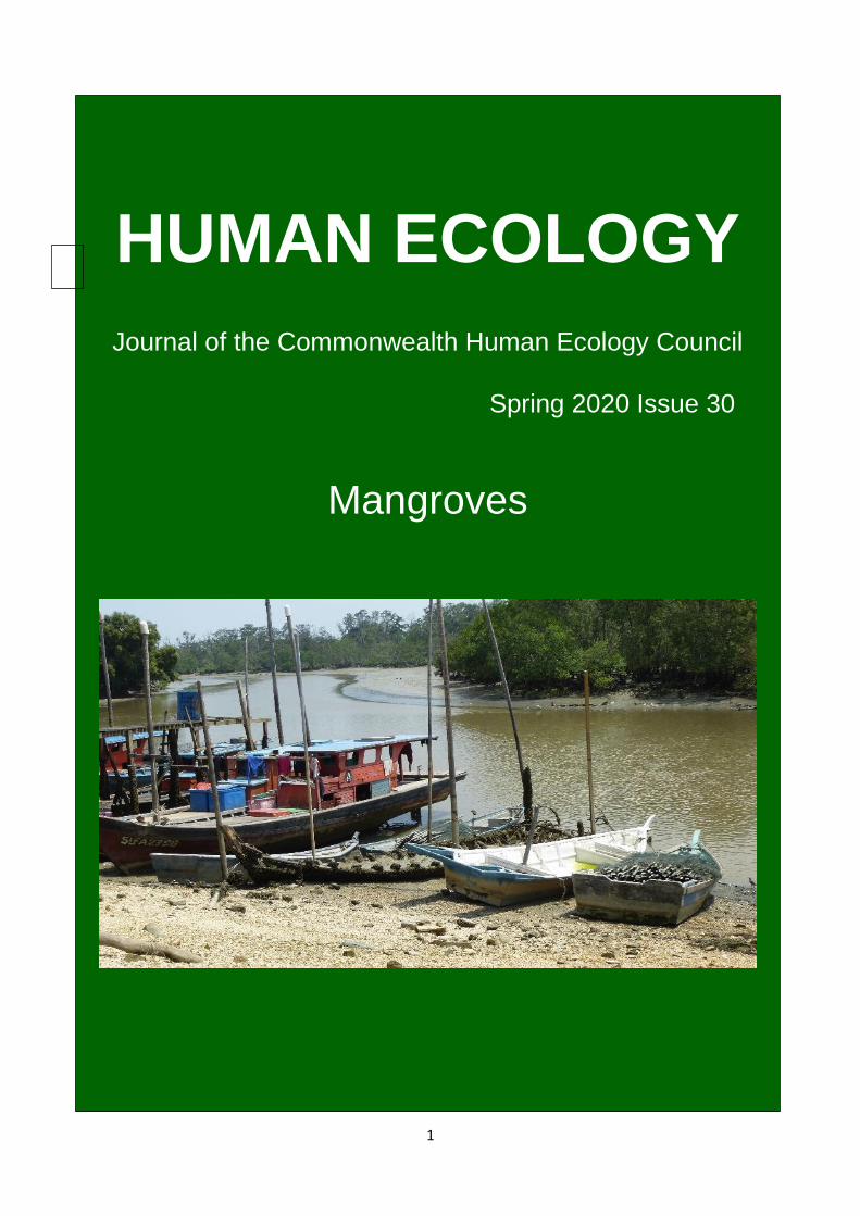
(Cover picture "Mangroves and local fishing boats at Sungai Buloh, Selangor, Malaysia: the mangroves
are an important fish breeding ground” (Photo Ian Douglas)
3
CHEC Journal Mangrove Special Issue
Contents
Page
Foreword Ian Douglas and Eva Ekehorn
5
1. 1. Music of Mother Mangrove (POEM) Donnell Davis
6
2. 2. Mangroves: an introduction Ian Douglas
8
3. 3. The Going Gets Tough for Mangroves Aldrie Amir
16
4. 4. Mangrove harbingers of coastal degradation seen in their responses to global climate change coupled with ever-increasing human pressures Norman C. Duke
19
5. 5. Mangrove ecosystem and coastal livelihood with special reference to the Indian scenario Dinesh Kaippilly, Geeji M. Tharanath and E.R. Chinchu.
24
6. 6. Mangroves in The Gambia: the Bolongfenyo Community Wildlife Reserve, A Gambian community-based organisation’s efforts to conserve mangroves. Badara Bajo
28
7. 7. Updates on Impacts of Climate Change on Mangroves Joanna C. Ellison
31
8. 8. Mangrove Ecosystem-based Adaptation: Advice on Improved Success Joanna C. Ellison
37
9. 9. Jangigir - Building Better Biomes: Coastal communities renewing mangroves as resilient climate infrastructure Donnell Davis
41
10. 10. Mangrove Conservation in Australia: Involving all People Janine Pierce
44
11. 11. Mangroves in New Zealand – a love-hate story Michael Donoghue
49
4
The Commonwealth Human Ecology Council (CHEC) was formally created
on 19 November 1969 and celebrated its 50th Anniversary on
19 November 2019 with a well-attended lecture at the Royal Overseas
League, London, given by Professor Asha Kanwar, President and Chief
Executive Officer of the Commonwealth of Learning (CoL), based in
Vancouver, Canada, entitled “On-line Learning for Climate Crises: A
Commonwealth Perspective”. A summary of fifty years of achievement
can be viewed on CHEC’s website [email protected]
To mark this special anniversary, as well as the
Commonwealth’s 70th Anniversary since the signing of the London
Declaration, CHEC has produced a journal on Mangroves. This has been
prepared with the Kigali CHOGM in mind and also in support of the
Commonwealth’s Blue Charter. CHOGM has been postponed into 2021
but the contents will remain relevant.
I take this opportunity to thank all the contributors for the time and
special efforts they have made to meet our deadlines.
Mark Robinson
Chairman, CHEC
5
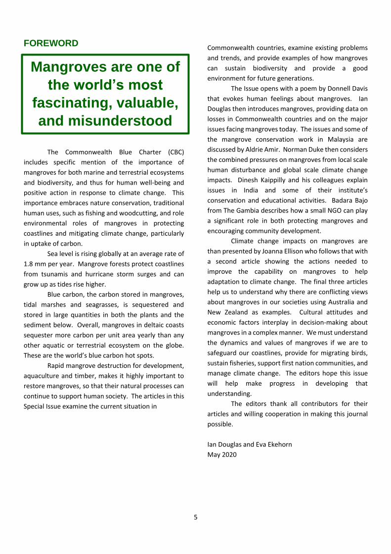
FOREWORD
2019 marked the 70th Anniversary Commonwealth of
Nations To mark the anniversary, CHEC has collected
evidence of state of mangrove ecosystems and good
practices for mangroves preservation and restoration
in the Commonwealth.
The Commonwealth Blue Charter (CBC)
includes specific mention of the importance of
mangroves for both marine and terrestrial ecosystems
and biodiversity, and thus for human well-being and
positive action in response to climate change. This
importance embraces nature conservation, traditional
human uses, such as fishing and woodcutting, and role
environmental roles of mangroves in protecting
coastlines and mitigating climate change, particularly
in uptake of carbon.
Sea level is rising globally at an average rate of
1.8 mm per year. Mangrove forests protect coastlines
from tsunamis and hurricane storm surges and can
grow up as tides rise higher.
Blue carbon, the carbon stored in mangroves,
tidal marshes and seagrasses, is sequestered and
stored in large quantities in both the plants and the
sediment below. Overall, mangroves in deltaic coasts
sequester more carbon per unit area yearly than any
other aquatic or terrestrial ecosystem on the globe.
These are the world’s blue carbon hot spots.
Rapid mangrove destruction for development,
aquaculture and timber, makes it highly important to
restore mangroves, so that their natural processes can
continue to support human society. The articles in this
Special Issue examine the current situation in
Commonwealth countries, examine existing problems
and trends, and provide examples of how mangroves
can sustain biodiversity and provide a good
environment for future generations.
The Issue opens with a poem by Donnell Davis
that evokes human feelings about mangroves. Ian
Douglas then introduces mangroves, providing data on
losses in Commonwealth countries and on the major
issues facing mangroves today. The issues and some of
the mangrove conservation work in Malaysia are
discussed by Aldrie Amir. Norman Duke then considers
the combined pressures on mangroves from local scale
human disturbance and global scale climate change
impacts. Dinesh Kaippilly and his colleagues explain
issues in India and some of their institute’s
conservation and educational activities. Badara Bajo
from The Gambia describes how a small NGO can play
a significant role in both protecting mangroves and
encouraging community development.
Climate change impacts on mangroves are
than presented by Joanna Ellison who follows that with
a second article showing the actions needed to
improve the capability on mangroves to help
adaptation to climate change. The final three articles
help us to understand why there are conflicting views
about mangroves in our societies using Australia and
New Zealand as examples. Cultural attitudes and
economic factors interplay in decision-making about
mangroves in a complex manner. We must understand
the dynamics and values of mangroves if we are to
safeguard our coastlines, provide for migrating birds,
sustain fisheries, support first nation communities, and
manage climate change. The editors hope this issue
will help make progress in developing that
understanding.
The editors thank all contributors for their
articles and willing cooperation in making this journal
possible.
Ian Douglas and Eva Ekehorn
May 2020
Mangroves are one of
the world’s most
fascinating, valuable,
and misunderstood
vegetation
formations.
6
1. Music of Mother Mangrove
Donnell Davis CHEC Australia
Morning birds herald the dawn in colours of pink and lilac sky over indigo velvet ocean
While the tide brings new smells of enthusiasm for life.
Night’s peace is shattered.
New energy in complicated patterns of matted roots and chaotic branches
Mixed with strange textures of murky, smooth, dappled, rough, sharp.
Cool wafts of sea breeze still nurtures the sense of serene while
Rhythmic movements of salty water soothes.
The lapping lover of the sea comes to lick his complement of land
fringed by mangroves, in tantalising interaction
for an amazing commune in the web of life.
Pacific Masculinity meets the anchored Feminine land
of mud and sand and silt.
Her strong tentacles of green, red and black mangroves
muster up all to her bosom
to provide the safe haven
for microscopic life, fish, insects, biota.
Insatiable fish hatcheries await brunch
of mosquito larvae, mucous nutrients and smelly flotsam,
as the day stretches into hot humid bright glaring colours.
The drone of buzzing stinging insects echoes the industrious duty of the day.
The shade provided by Mother Mangrove is shared by
another range of species, all in pursuit of their
delicious saline estuarine bounty.
Long steaming afternoons laze in the midst of
lethargic hum of the living labyrinth.
Then stealthily, intense storm clouds overhead dump their deluge,
merging and purging, as wild winds whisk howls and sighs
until the rage and fury subsides.
All species are safe in her protective arms.
A moment of silence
7
Punctuating quiet interconnected spirals of life are
sporadic flocks of noisy visitors, who survey
from white coral coasts to deep turquoise seas to
dappled mud and muck of the estuaries.
Inlets are rich in their own meld of intoxicating cocktails
With their stench of yesterday’s celebrations and
casualties of coastal life.
Evening birds moan
On flat horizons of red and orange and purple,
as sun sets on the staircase to the sky.
The taste of the sticky salt remains.
The feel of granular coating stays, but defenceless from punctures of
pestering midges and various vectors.
Then murderous cries of the mutton birds
pierce the night and the nerves, before a final hush of evening darkness.
A peaceful nocturnal chapter renews the strength for tomorrow’s tropical tale.
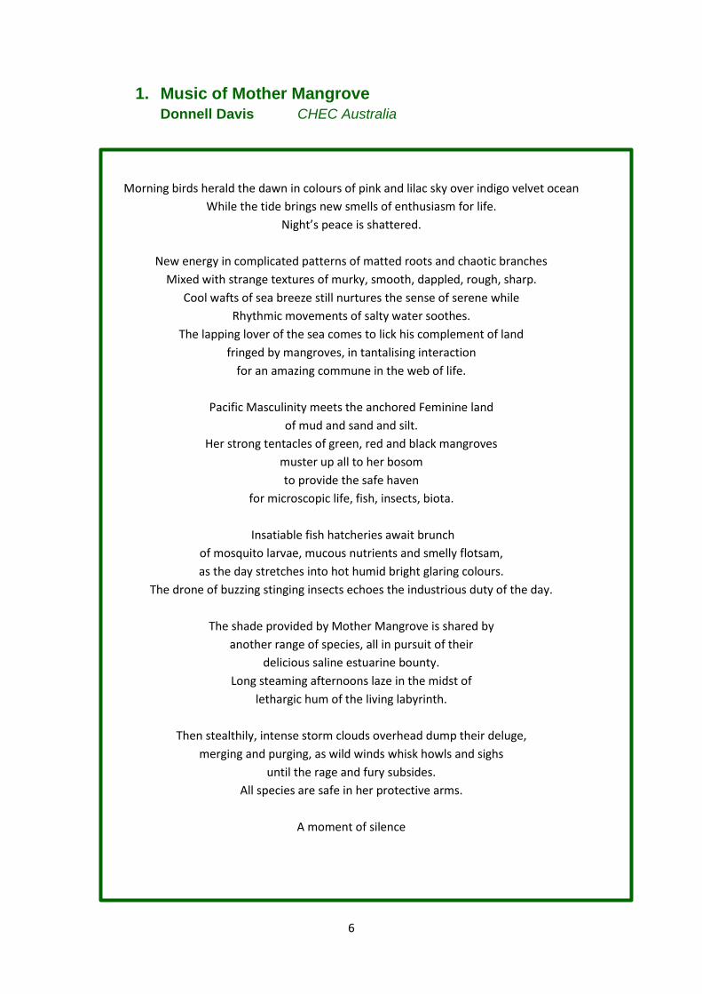
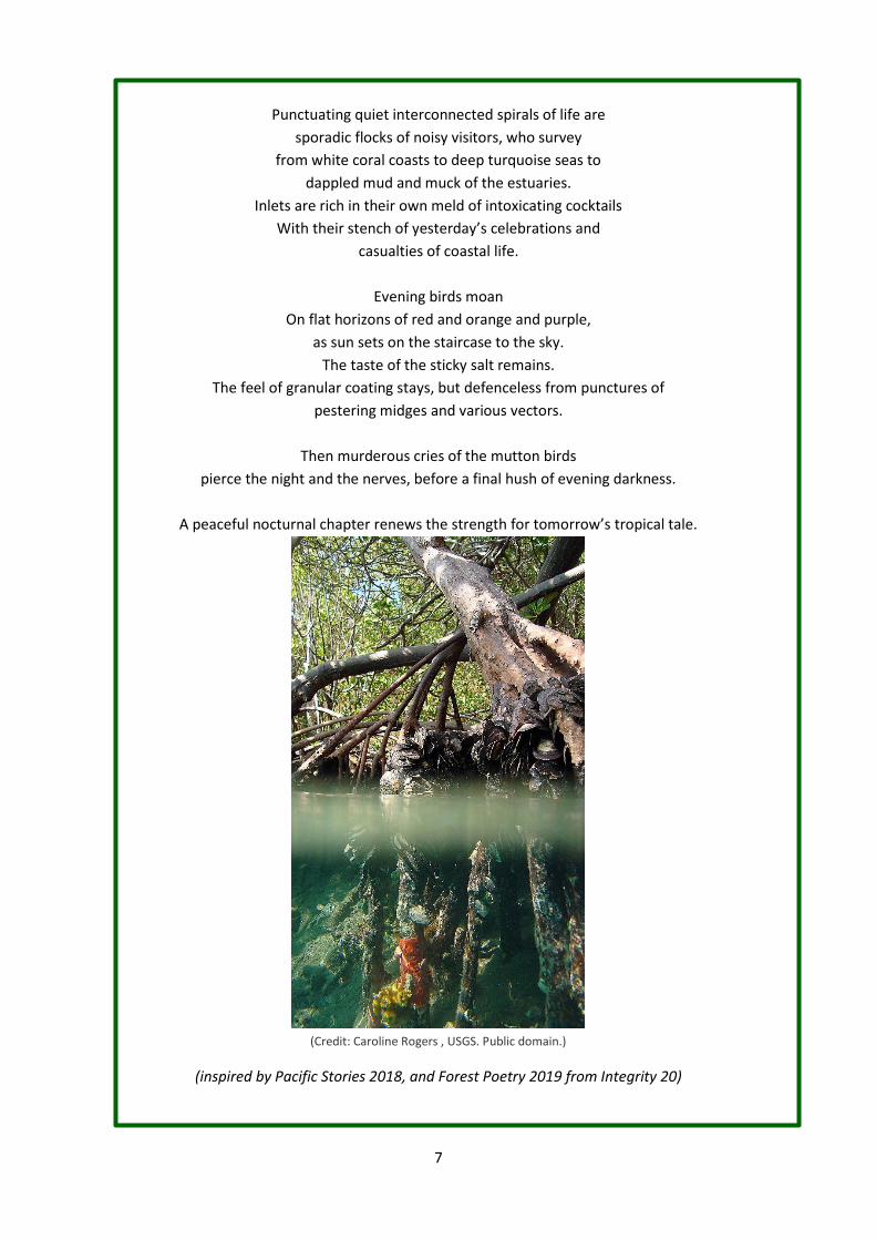
(Credit: Caroline Rogers , USGS. Public domain.)
(inspired by Pacific Stories 2018, and Forest Poetry 2019 from Integrity 20)
8
2. Mangroves: an introduction Ian Douglas University of Manchester and Commonwealth Human Ecology Council
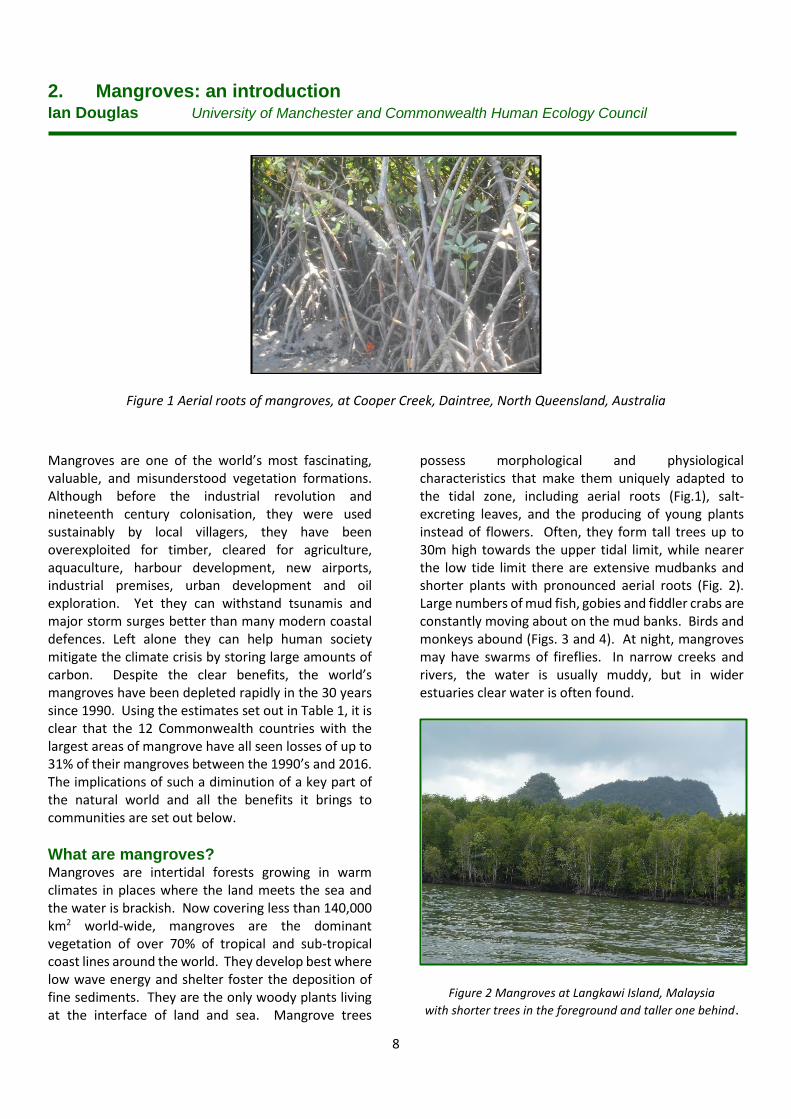
Figure 1 Aerial roots of mangroves, at Cooper Creek, Daintree, North Queensland, Australia
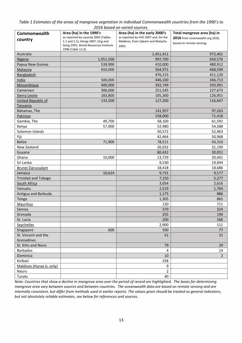
Mangroves are one of the world’s most fascinating, valuable, and misunderstood vegetation formations. Although before the industrial revolution and nineteenth century colonisation, they were used sustainably by local villagers, they have been overexploited for timber, cleared for agriculture, aquaculture, harbour development, new airports, industrial premises, urban development and oil exploration. Yet they can withstand tsunamis and major storm surges better than many modern coastal defences. Left alone they can help human society mitigate the climate crisis by storing large amounts of carbon. Despite the clear benefits, the world’s mangroves have been depleted rapidly in the 30 years since 1990. Using the estimates set out in Table 1, it is clear that the 12 Commonwealth countries with the largest areas of mangrove have all seen losses of up to 31% of their mangroves between the 1990’s and 2016. The implications of such a diminution of a key part of the natural world and all the benefits it brings to communities are set out below.
What are mangroves? Mangroves are intertidal forests growing in warm climates in places where the land meets the sea and the water is brackish. Now covering less than 140,000 km2 world-wide, mangroves are the dominant vegetation of over 70% of tropical and sub-tropical coast lines around the world. They develop best where low wave energy and shelter foster the deposition of fine sediments. They are the only woody plants living at the interface of land and sea. Mangrove trees
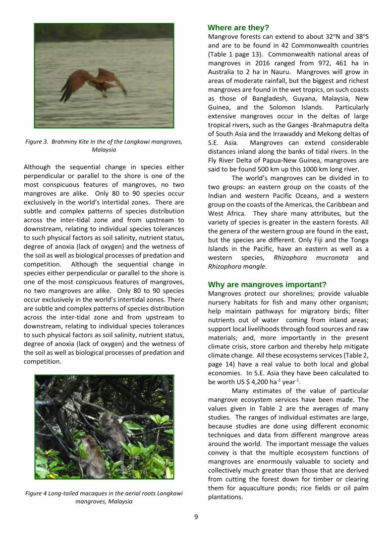
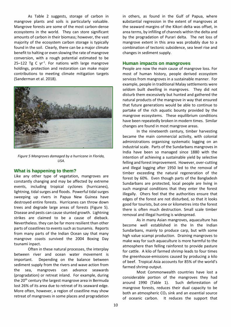
possess morphological and physiological characteristics that make them uniquely adapted to the tidal zone, including aerial roots (Fig.1), salt-excreting leaves, and the producing of young plants instead of flowers. Often, they form tall trees up to 30m high towards the upper tidal limit, while nearer the low tide limit there are extensive mudbanks and shorter plants with pronounced aerial roots (Fig. 2). Large numbers of mud fish, gobies and fiddler crabs are constantly moving about on the mud banks. Birds and monkeys abound (Figs. 3 and 4). At night, mangroves may have swarms of fireflies. In narrow creeks and rivers, the water is usually muddy, but in wider estuaries clear water is often found.
Figure 2 Mangroves at Langkawi Island, Malaysia
with shorter trees in the foreground and taller one behind.
9
Figure 3. Brahminy Kite in the of the Langkawi mangroves,
Malaysia Although the sequential change in species either perpendicular or parallel to the shore is one of the most conspicuous features of mangroves, no two mangroves are alike. Only 80 to 90 species occur exclusively in the world’s intertidal zones. There are subtle and complex patterns of species distribution across the inter-tidal zone and from upstream to downstream, relating to individual species tolerances to such physical factors as soil salinity, nutrient status, degree of anoxia (lack of oxygen) and the wetness of the soil as well as biological processes of predation and competition. Although the sequential change in species either perpendicular or parallel to the shore is one of the most conspicuous features of mangroves, no two mangroves are alike. Only 80 to 90 species occur exclusively in the world’s intertidal zones. There are subtle and complex patterns of species distribution across the inter-tidal zone and from upstream to downstream, relating to individual species tolerances to such physical factors as soil salinity, nutrient status, degree of anoxia (lack of oxygen) and the wetness of the soil as well as biological processes of predation and competition.
Figure 4 Long-tailed macaques in the aerial roots Langkawi
mangroves, Malaysia
Where are they? Mangrove forests can extend to about 32oN and 38oS and are to be found in 42 Commonwealth countries (Table 1 page 13). Commonwealth national areas of mangroves in 2016 ranged from 972, 461 ha in Australia to 2 ha in Nauru. Mangroves will grow in areas of moderate rainfall, but the biggest and richest mangroves are found in the wet tropics, on such coasts as those of Bangladesh, Guyana, Malaysia, New Guinea, and the Solomon Islands. Particularly extensive mangroves occur in the deltas of large tropical rivers, such as the Ganges -Brahmaputra delta of South Asia and the Irrawaddy and Mekong deltas of S.E. Asia. Mangroves can extend considerable distances inland along the banks of tidal rivers. In the Fly River Delta of Papua-New Guinea, mangroves are said to be found 500 km up this 1000 km long river.
The world’s mangroves can be divided in to two groups: an eastern group on the coasts of the Indian and western Pacific Oceans, and a western group on the coasts of the Americas, the Caribbean and West Africa. They share many attributes, but the variety of species is greater in the eastern forests. All the genera of the western group are found in the east, but the species are different. Only Fiji and the Tonga Islands in the Pacific, have an eastern as well as a western species, Rhizophora mucronata and Rhizophora mangle.
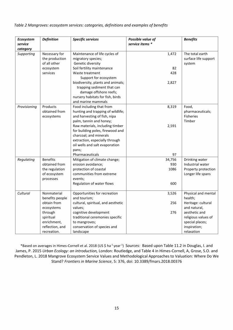
Why are mangroves important? Mangroves protect our shorelines; provide valuable nursery habitats for fish and many other organism; help maintain pathways for migratory birds; filter nutrients out of water coming from inland areas; support local livelihoods through food sources and raw materials; and, more importantly in the present climate crisis, store carbon and thereby help mitigate climate change. All these ecosystems services (Table 2, page 14) have a real value to both local and global economies. In S.E. Asia they have been calculated to be worth US $ 4,200 ha-1 year-1.
Many estimates of the value of particular mangrove ecosystem services have been made. The values given in Table 2 are the averages of many studies. The ranges of individual estimates are large, because studies are done using different economic techniques and data from different mangrove areas around the world. The important message the values convey is that the multiple ecosystem functions of mangroves are enormously valuable to society and collectively much greater than those that are derived from cutting the forest down for timber or clearing them for aquaculture ponds; rice fields or oil palm plantations.
10
As Table 2 suggests, storage of carbon in mangrove plants and soils is particularly valuable. Mangrove forests are some of the most carbon-dense ecosystems in the world. They can store significant amounts of carbon in their biomass; however, the vast majority of the ecosystem carbon storage is typically found in the soil. Clearly, there can be a major climate benefit to halting or even slowing the rate of mangrove conversion, with a rough potential estimated to be 25–122 Tg C yr-1. For nations with large mangrove holdings, protection and restoration can make major contributions to meeting climate mitigation targets (Sanderman et al. 2018).
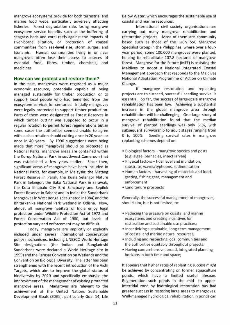
Figure 5 Mangroves damaged by a hurricane in Florida, USA.
What is happening to them? Like any other type of vegetation, mangroves are constantly changing and may be affected by extreme events, including tropical cyclones (hurricanes), lightning, tidal surges and floods. Powerful tidal surges sweeping up rivers in Papua New Guinea have destroyed entire forests. Hurricanes can throw down trees and degrade large areas of forests (Figure 5). Disease and pests can cause stunted growth. Lightning strikes are claimed to be a cause of dieback. Nevertheless. they can be far more resilient than other parts of coastlines to events such as tsunamis. Reports from many parts of the Indian Ocean say that many mangrove coasts survived the 2004 Boxing Day tsunami inpact.
Often in these natural processes, the interplay between river and ocean water movement is important. Depending on the balance between sediment supply from the rivers and wave action from the sea, mangroves can advance seawards (progradation) or retreat inland. For example, during the 20th century the largest mangrove area in Bermuda lost 26% of its area due to retreat of its seaward edge. More often, however, a region of coastline may show retreat of mangroves in some places and progradation
in others, as found in the Gulf of Papua, where substantial regression in the extent of mangroves at the seaward margins of the Kikori delta was offset, in area terms, by infilling of channels within the delta and by the progradation of Purari delta. The net loss of mangrove extent in this area was probably due to a combination of tectonic subsidence, sea level rise and changes in sediment supply.
Human impacts on mangroves People are now the main cause of mangrove loss. For most of human history, people derived ecosystem services from mangroves in a sustainable manner. For example, people in traditional Malay settlements were seldom built dwelling in mangroves. They did not disturb them excessively but hunted and gathered the natural products of the mangrove in way that ensured that future generations would be able to continue to partake of the rich aquatic bounty provided by the mangrove ecosystems. These equilibrium conditions have been repeatedly broken in modern times. Similar changes are found in most mangrove areas.
In the nineteenth century, timber harvesting became the main commercial activity, with colonial administrations organising systematic logging on an industrial scale. Parts of the Sundarbans mangroves in India have been so managed since 1880 with the intention of achieving a sustainable yield by selective felling and forest improvement. However, over-cutting and illegal logging after 1950 led to the removal of timber exceeding the natural regeneration of the forest by 60%. Even though parts of the Bangladesh Sundarbans are protected, local people are living in such marginal conditions that they enter the forest illegally. Ohers feel that the authorities ensure that edges of the forest are not disturbed, so that it looks good for tourists, but one or kilometres into the forest there is often much destruction. Small scale timber removal and illegal hunting is widespread.
As in many Asian mangroves, aquaculture has become well established in the In the Indian Sundarbans, mainly to produce carp, but with some high value scampi production. Draining mangroves to make way for such aquaculture is more harmful to the atmosphere than felling rainforest to provide pasture for cattle. A kilo of farmed shrimp leads to four times the greenhouse-emissions caused by producing a kilo of beef. Tropical Asia accounts for 85% of the world’s farmed shrimp output.
Most Commonwealth countries have lost a considerable portion of the mangroves they had around 1990 (Table 1). Such deforestation of mangrove forests, reduces their dual capacity to be both an atmospheric CO2 sink and an essential source of oceanic carbon. It reduces the support that
11
mangrove ecosystems provide for both terrestrial and marine food webs, particularly adversely affecting fisheries. Forest degradation risks losing mangrove ecosystem service benefits such as the buffering of seagrass beds and coral reefs against the impacts of river-borne siltation, or protection of coastal communities from sea-level rise, storm surges, and tsunamis. Human communities living in or near mangroves often lose their access to sources of essential food, fibres, timber, chemicals, and medicines.
How can we protect and restore them? In the past, mangroves were regarded as a major economic resource, potentially capable of being managed sustainably for timber production or to support local people who had benefited from the ecosystem services for centuries. Initially mangroves were legally protected to support timber production. Parts of them were designated as Forest Reserves in which timber cutting was supposed to occur in a regular rotation to permit forest regenerations but in some cases the authorities seemed unable to agree with such a rotation should cutting once in 20 years or once in 40 years. By 1990 suggestions were being made that more mangroves should be protected as National Parks: mangrove areas are contained within the Korup National Park in southwest Cameroon that was established a few years earlier. Since then, significant areas of mangrove have been included in National Parks, for example, in Malaysia: the Matang Forest Reserve in Perak, the Kuala Selangor Nature Park in Selangor, the Bako National Park in Sarawak, the Kota Kinabalu City Bird Sanctuary and Sepilok Forest Reserve in Sabah; and in India: the Sundarbans Mangroves in West Bengal (designated in1984) and the Bhitarkanika National Park wetland in Odisha. Now, almost all mangrove habitats of India enjoy legal protection under Wildlife Protection Act of 1972 and Forest Conservation Act of 1980, but levels of protection vary and enforcement may be difficult.
Today, mangroves are implicitly or explicitly included under several international conservation policy mechanisms, including UNESCO World Heritage Site designations (the Indian and Bangladeshi Sundarbans were declared a World Heritage site in 1999) and the Ramsar Convention on Wetlands and the Convention on Biological Diversity. The latter has been strengthened with the recent introduction of the Aichi Targets, which aim to improve the global status of biodiversity by 2020 and specifically emphasise the improvement of the management of existing protected mangrove areas. Mangroves are relevant to the achievement of the United Nations Sustainable Development Goals (SDGs), particularly Goal 14, Life
Below Water, which encourages the sustainable use of coastal and marine resources.
International civil society organisations are carrying out many mangrove rehabilitation and restoration projects. Most of them are community based such as those of the IUCN SSC Mangrove Specialist Group in the Philippines, where over a four-year period, some 100,000 mangroves were planted, helping to rehabilitate 107.8 hectares of mangrove forest. Mangrove for the Future (MFF) is assisting the Maldives to adopt a National Integrated Coastal Management approach that responds to the Maldives National Adaptation Programme of Action on Climate Change.
If mangrove restoration and replanting projects are to succeed, successful seedling survival is essential. So far, the success of large-scale mangrove rehabilitation has been low. Achieving a substantial increase in the global mangrove area through rehabilitation will be challenging. One large study of mangrove rehabilitation found that the median survival of planted seedlings was only 51%, with subsequent survivorship to adult stages ranging from 0 to 100%. Seedling survival rates in mangrove replanting schemes depend on:
• Biological factors – mangrove species and pests
(e.g. algae, barnacles, insect larvae) • Physical factors – tidal level and inundation,
substrate, waves/typhoons, sedimentation • Human factors – harvesting of materials and food,
grazing, fishing gear, management and enforcement
• Land tenure prospects Generally, the successful management of mangroves, should aim, but is not limited, to: • Reducing the pressure on coastal and marine
ecosystems and creating incentives for restoration and sustainable use practices;
• Incentivizing sustainable, long-term management of coastal and marine natural resources;
• Including and respecting local communities and the authorities equitably throughout projects;
• Having comprehensive, broad, integrated planning horizons in both time and space;
It appears that higher rates of replanting success might be achieved by concentrating on former aquaculture ponds, which have a limited useful lifespan. Regeneration such ponds in the mid- to upper-intertidal zone by hydrological restoration has had greater success in restoring large areas to mangroves. Well-managed hydrological rehabilitation in ponds can
12
lead to greater ecosystem service provision. With thousands of hectares of disused ponds becoming available, their large-scale rehabilitation appears to be achievable.
What can be done is illustrated by the Mikoko Pamoja project in Kenya which demonstrates that investing in a mangrove project can deliver a complex set of benefits, some of which may generate revenues, to cover an array of costs. The project which manages 117 hectares of mangroves and involves 498 households, provides an excellent example of how a mangrove conservation project can include a number of activities and aims, including direct protection and restoration, scientific experimentation and research, capacity building and learning, community empowerment and support, and the sale of mangrove-related goods and services, in this case, carbon credits.
To achieve long-term sustainability, this project has to continue to keep up the community benefits arising out of the carbon credits as these credits are based on the ongoing conservation of the mangroves. If the perceived cost of conservation, e.g. the opportunity cost of not using the mangrove timber, becomes greater than the perceived benefit of the carbon credits to the local community, then the mangroves will be at risk. The community has therefore to identify other sources of mangrove-friendly incomes such as sustainable harvesting of mangrove resources and ecotourism.
Making the economic case In the efforts to save and restore mangroves, the valuing nature argument needs to be applied. Policy makers, local governments and communities need to appreciate that natural capital can substitute for manufactured capital, e.g. mangroves rather than seawalls for coastal defence. Restoring coastal mangrove forests does not just protect coastal communities from more dangerous storm surges and tsunamis, it also provides critical habitat to sustain local fisheries and the carbon storage so important in terms of mitigating the climate crisis. Taken together, the values of the ecosystem service benefits of mangrove preservation and restoration are up to 10 times the costs. These crucial ecosystems, and many others, underpin whole economies and societies, providing food and fuel, supporting livelihoods, and fighting climate change itself by capturing carbon from the atmosphere. A thriving natural environment is thus a cornerstone of building resilience across all sectors. Future changes in geological and climatic processes, especially sea-level rise, will greatly affect both mangroves and the human communities which rely upon them. Thus, in the future mangroves will need to be managed and adapted to cope with both human and geological drivers of change. Action is needed now to prevent further mangrove loss and the restore and safeguard existing mangrove areas.
Further Reading Friess, D.A,, Rogers, K., Lovelock, C.E., Krauss, K.W., Hamilton, S.E., Lee, S.Y., Lucas, R., Primavera, J., Rajkaran, A. and Suhua S. 2019 The State of the World’s Mangrove Forests: Past, Present, and Future, Annual Review of Environment and Resources, 44: 89–115, https://doi.org/10.1146/annurev-environ-101718-033302. Himes-Cornell, A., Grose, S.O. and Pendleton, L. 2018 Mangrove ecosystem services and methodological approaches to valuation: where do we stand? Frontiers in Marine Science, 5: 378, doi: 10.3389/fmars.2018.00376. Sanderman, J., Hengl, T., Fiske, G., Solvik, K., Adame, M.F., Benson, L., Bukoski, J.J., Carnel, P., Cifuentes-Jara, M., Daniel Donato, D., Duncan, C., Eid, E.M., Ermgassen, P. zu, Ewers Lewis, C.J., Macreadie, P.I., Glass, L., Gress, S., Jardine, S.l., Jones, T.G., Nsombo, E.M., Rahman, M.M., Sanders, C.J., Spalding, M. and Landis, E. (2018) A global map of mangrove forest soil carbon at 30 m spatial resolution, Environmental Research Letters, 13, 055002. doi: 10.1088/1748-9326/aabe1c
References:
Alongi , D.M. 2007 Mangrove Forests of Papua, in Marshall, A.J. and Beeheler, B.M. (eds) The Ecology of Papua Part 2, Singapore: Periplus, 824-857. FAO 2007 The world's mangroves 1980-2005: A thematic study prepared in the framework of the Global Forest Resources Assessment 2005, FAO Forestry Paper, 153, Rome: Food and Agriculture Organization of the United Nations Lacerda L.D. de (ed.) 2002 Mangrove Ecosystems: Function and Management, Berlin: Springer Verlag. Oceanwealth.org 2020 Explore the Mangrove Restoration Potential Mapping Tool, https://oceanwealth.org/explore-the-mangrove-restoration-potential-mapping-tool/ [Accessed 11 March 2020] Ong, J.E. and Gong W.K. 1991 Mangroves, in Kiew, R. (ed.) The State of Nature Conservation in Malaysia, Kuala Lumpur: Malayan Nature Society, 22-28. Saleem, A. and Nielysha, A. 2003 Characteristics, status and need for conservation of mangrove ecosystems in the Republic of Maldives, Indian Ocean, Journal of the National Science Foundation, Sri Lanka, 31 (1&2) 201-213. World Resources Institute 1996 World Resources 1996-97, Oxford: Oxford University Press.
13
Table 1 Estimates of the areas of mangrove vegetation in individual Commonwealth countries from the 1990’s to 2016 based on varied sources.
Commonwealth country
Area (ha) in the 1990’s as reported by Lacerda 2002 (Tables 1.1 and 2.1); Alongi 2007; Ong and Gong 1991; World Resources Institute 1996 (Table 11.4).
Area (ha) in the early 2000’s as reported by FAO 2007 and, for the Maldives, from Saleem and Nielysha
2003.
Total mangrove area (ha) in 2016 from oceanwealth.org 2020,
based on remote sensing.
Australia 1,451,411 972,461
Nigeria 1,051,500 997,700 650,576
Papua New Guinea 539,900 410,000 480,912
Malaysia 650,000 564,971 468,599
Bangladesh 476,215 411,120
India 500,000 446,100 346,713
Mozambique 400,000 392,749 293,991
Cameroon 306,000 251,545 227,673
Sierra Leone 183,800 105,300 126,951
United Republic of Tanzania
133,500 127,200 116,847
Bahamas, The 141,957 97,263
Pakistan 158,000 71,418
Gambia, The 49,700 58,100 61,592
Kenya 57,000 52,980 54,588
Solomon Islands 50,572 52,963
Fiji 42,464 50,968
Belize 71,900 78,511 43,316
New Zealand 26,032 31,190
Guyana 80,432 30,051
Ghana 10,000 13,729 20,401
Sri Lanka 9,530 19,944
Brunei Darussalam 18,418 18,686
Jamaica 10,624 9,731 9,577
Trinidad and Tobago 7,150 5,277
South Africa 3,054 2,616
Vanuatu 2,519 1,764
Antigua and Barbuda 1,175 886
Tonga 1,305 865
Mauritius 120 711
Samoa 370 324
Grenada 255 194
St. Lucia 200 166
Seychelles 2,900 111
Singapore 600 500 77
St. Vincent and the Grenadines
51 31
St. Kitts and Nevis 79 29
Barbados 4 14
Dominica 10 2
Kiribati 258
Maldives (Huraa Is. only) 9
Nauru 2
Tuvalu 40
Note: Countries that show a decline in mangrove area over the period of record are highlighted. The bases for determining mangrove area vary between sources and between countries. The oceanwealth data are based on remote sensing and are internally consistent, but differ from methods used in earlier reports. The values given should be treated as general indicators, but not absolutely reliable estimates, see below for references and sources.
14
Sources: 1990’s: Lacerda 2002 (Tables 1.1 and 2.1); Alongi 2007; Ong and Gong 1991; World Resources Institute 1996 (Table 11.4); 2000’s: as reported by FAO 2007 and, for the Maldives, from Saleem and Nielysha 2003: 2016 from oceanwealth.org 2020, based on remote sensing.
References for sources:
Alongi , D.M. 2007 Mangrove Forests of Papua, in Marshall, A.J. and Beeheler, B.M. (eds) The Ecology of Papua Part 2, Singapore: Periplus, 824-857.
FAO 2007 The world's mangroves 1980-2005: A thematic study prepared in the framework of the Global Forest Resources Assessment 2005, FAO Forestry Paper, 153, Rome: Food and Agriculture Organization of the United Nations
Lacerda L.D. de (ed.) 2002 Mangrove Ecosystems: Function and Management, Berlin: Springer Verlag.
Oceanwealth.org 2020 Explore the Mangrove Restoration Potential Mapping Tool, https://oceanwealth.org/explore-the-mangrove-restoration-potential-mapping-tool/ [Accessed 11 March 2020]
Ong, J.E. and Gong W.K. 1991 Mangroves, in Kiew, R. (ed.) The State of Nature Conservation in Malaysia, Kuala Lumpur: Malayan Nature Society, 22-28.
Saleem, A. and Nielysha, A. 2003 Characteristics, status and need for conservation of mangrove ecosystems in the Republic of Maldives, Indian Ocean, Journal of the National Science Foundation, Sri Lanka, 31 (1&2) 201-213.
World Resources Institute 1996 World Resources 1996-97, Oxford: Oxford University Press
Biscayne National Park Caesar Creek
15
Table 2 Mangroves: ecosystem services: categories, definitions and examples of benefits
Ecosystem service category
Definition Specific services Possible value of service items *
Benefits
Supporting Necessary for the production of all other ecosystem services
Maintenance of life cycles of migratory species; Genetic diversity Soil fertility maintenance Waste treatment
Support for ecosystem biodiversity, plants and animals;
trapping sediment that can damage offshore reefs;
nursery habitats for fish, birds and marine mammals
1,472
82 428
2,827
The total earth surface life support system
Provisioning Products obtained from ecosystems
Food including that from hunting and trapping of wildlife; and harvesting of fish, nipa palm, tannin and honey; Raw materials, including timber for building poles, firewood and charcoal; and minerals extraction, especially through oil wells and salt evaporation pans; Pharmaceuticals
8,319
2,591
97
Food, pharmaceuticals; Fisheries Timber
Regulating Benefits obtained from the regulation of ecosystem processes
Mitigation of climate change; erosion avoidance; protection of coastal communities from extreme events; Regulation of water flows
34,756 930
1086
600
Drinking water Industrial water Property protection Longer life spans
Cultural Nonmaterial benefits people obtain from ecosystems through spiritual enrichment, reflection, and recreation.
Opportunities for recreation and tourism; cultural, spiritual, and aesthetic values; cognitive development traditional ceremonies specific to mangroves; conservation of species and landscape
3,526
256
276
Physical and mental health; Heritage: cultural and natural, aesthetic and religious values of special places; inspiration; relaxation
*Based on averages in Himes-Cornell et al. 2018 (US $ ha-1 year-1) Sources: Based upon Table 11.2 in Douglas, I. and James, P. 2015 Urban Ecology: an introduction, London: Routledge, and Table 4 in Himes-Cornell, A, Grose, S.O. and
Pendleton, L. 2018 Mangrove Ecosystem Service Values and Methodological Approaches to Valuation: Where Do We Stand? Frontiers in Marine Science, 5: 376, doi: 10.3389/fmars.2018.00376
16
3. The Going Gets Tough for Mangroves A. Aldrie Amir Institute for Environment and Development (LESTARI), Universiti Kebangsaan
Malaysia, 43600 Bangi, Selangor [email protected]
Located along the sheltered coastlines of tropical and subtropical countries, mangrove forest habitats provide multiple benefits to humans (Duke 2007). In addition to providing buffers from winds and waves, the forest provides an enormous range of supplies such as foods, medicine and timber and also, it performs key ecosystem processes in regulating water and nutrients, and providing habitat for enormous range of flora and fauna, among others. However, today mangroves are facing bigger, stronger, heavier and faster challenges. From illegal encroachment and cutting, to continuous expansion of humans’ socioeconomic development, to the pressure from human-induced changes in sea levels and climate, mangroves are at risk from disturbances and degradation coming from all angles (Amir 2018).
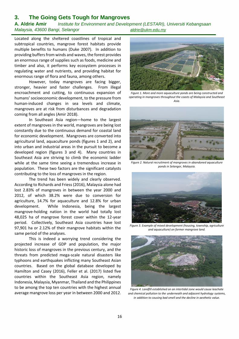
In Southeast Asia region—home to the largest extent of mangroves in the world, mangroves are being lost constantly due to the continuous demand for coastal land for economic development. Mangroves are converted into agricultural land, aquaculture ponds (figures 1 and 2), and into urban and industrial areas in the pursuit to become a developed region (figures 3 and 4). Many countries in Southeast Asia are striving to climb the economic ladder while at the same time seeing a tremendous increase in population. These two factors are the significant catalysts contributing to the loss of mangroves in the region.
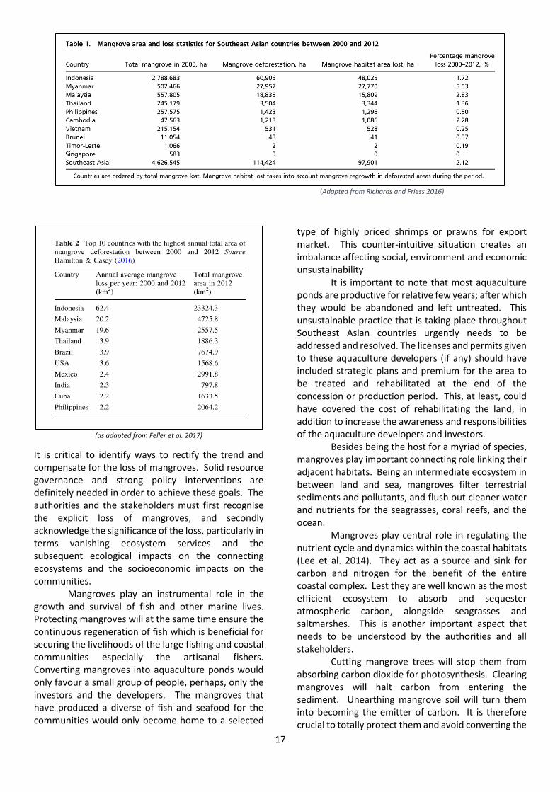
The trend has been widely and clearly observed. According to Richards and Friess (2016), Malaysia alone had lost 2.83% of mangroves in between the year 2000 and 2012, of which 38.2% were due to conversion for agriculture, 14.7% for aquaculture and 12.8% for urban development. While Indonesia, being the largest mangrove-holding nation in the world had totally lost 48,025 ha of mangrove forest cover within the 12-year period. Collectively, Southeast Asia countries have lost 97,901 ha or 2.12% of their mangrove habitats within the same period of the analyses.
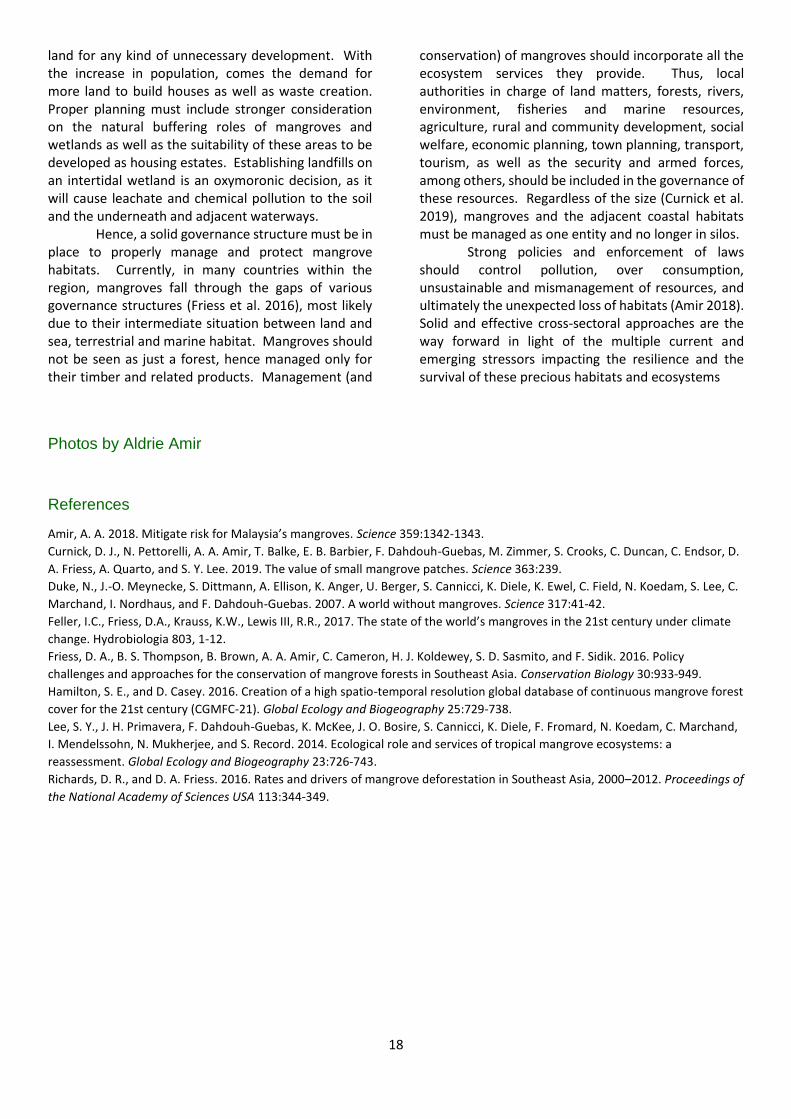
This is indeed a worrying trend considering the projected increase of GDP and population, the major historic loss of mangroves in the previous century, and the threats from predicted mega-scale natural disasters like typhoons and earthquakes inflicting many Southeast Asian countries. Based on the global database developed by Hamilton and Casey (2016), Feller et al. (2017) listed five countries within the Southeast Asia region, namely Indonesia, Malaysia, Myanmar, Thailand and the Philippines to be among the top ten countries with the highest annual average mangrove loss per year in between 2000 and 2012.
Figure 1. More and more aquaculture ponds are being constructed and operating in mangroves throughout the coasts of Malaysia and Southeast
Asia.
Figure 2. Natural recruitment of mangroves in abandoned aquaculture
ponds in Selangor, Malaysia.
Figure 3. Example of mixed development (housing, township, agriculture
and aquaculture) on former mangrove land.
Figure 4. Landfill established on an intertidal zone would cause leachate
and chemical pollution to the underneath and adjacent hydrology systems,
in addition to causing bad smell and the decline in aesthetic value.
17
(Adapted from Richards and Friess 2016)
(as adapted from Feller et al. 2017)
It is critical to identify ways to rectify the trend and compensate for the loss of mangroves. Solid resource governance and strong policy interventions are definitely needed in order to achieve these goals. The authorities and the stakeholders must first recognise the explicit loss of mangroves, and secondly acknowledge the significance of the loss, particularly in terms vanishing ecosystem services and the subsequent ecological impacts on the connecting ecosystems and the socioeconomic impacts on the communities.
Mangroves play an instrumental role in the growth and survival of fish and other marine lives. Protecting mangroves will at the same time ensure the continuous regeneration of fish which is beneficial for securing the livelihoods of the large fishing and coastal communities especially the artisanal fishers. Converting mangroves into aquaculture ponds would only favour a small group of people, perhaps, only the investors and the developers. The mangroves that have produced a diverse of fish and seafood for the communities would only become home to a selected
type of highly priced shrimps or prawns for export market. This counter-intuitive situation creates an imbalance affecting social, environment and economic unsustainability
It is important to note that most aquaculture ponds are productive for relative few years; after which they would be abandoned and left untreated. This unsustainable practice that is taking place throughout Southeast Asian countries urgently needs to be addressed and resolved. The licenses and permits given to these aquaculture developers (if any) should have included strategic plans and premium for the area to be treated and rehabilitated at the end of the concession or production period. This, at least, could have covered the cost of rehabilitating the land, in addition to increase the awareness and responsibilities of the aquaculture developers and investors.
Besides being the host for a myriad of species, mangroves play important connecting role linking their adjacent habitats. Being an intermediate ecosystem in between land and sea, mangroves filter terrestrial sediments and pollutants, and flush out cleaner water and nutrients for the seagrasses, coral reefs, and the ocean.
Mangroves play central role in regulating the nutrient cycle and dynamics within the coastal habitats (Lee et al. 2014). They act as a source and sink for carbon and nitrogen for the benefit of the entire coastal complex. Lest they are well known as the most efficient ecosystem to absorb and sequester atmospheric carbon, alongside seagrasses and saltmarshes. This is another important aspect that needs to be understood by the authorities and all stakeholders.
Cutting mangrove trees will stop them from absorbing carbon dioxide for photosynthesis. Clearing mangroves will halt carbon from entering the sediment. Unearthing mangrove soil will turn them into becoming the emitter of carbon. It is therefore crucial to totally protect them and avoid converting the
18
land for any kind of unnecessary development. With the increase in population, comes the demand for more land to build houses as well as waste creation. Proper planning must include stronger consideration on the natural buffering roles of mangroves and wetlands as well as the suitability of these areas to be developed as housing estates. Establishing landfills on an intertidal wetland is an oxymoronic decision, as it will cause leachate and chemical pollution to the soil and the underneath and adjacent waterways.
Hence, a solid governance structure must be in place to properly manage and protect mangrove habitats. Currently, in many countries within the region, mangroves fall through the gaps of various governance structures (Friess et al. 2016), most likely due to their intermediate situation between land and sea, terrestrial and marine habitat. Mangroves should not be seen as just a forest, hence managed only for their timber and related products. Management (and
conservation) of mangroves should incorporate all the ecosystem services they provide. Thus, local authorities in charge of land matters, forests, rivers, environment, fisheries and marine resources, agriculture, rural and community development, social welfare, economic planning, town planning, transport, tourism, as well as the security and armed forces, among others, should be included in the governance of these resources. Regardless of the size (Curnick et al. 2019), mangroves and the adjacent coastal habitats must be managed as one entity and no longer in silos.
Strong policies and enforcement of laws should control pollution, over consumption, unsustainable and mismanagement of resources, and ultimately the unexpected loss of habitats (Amir 2018). Solid and effective cross-sectoral approaches are the way forward in light of the multiple current and emerging stressors impacting the resilience and the survival of these precious habitats and ecosystems
Photos by Aldrie Amir
References
Amir, A. A. 2018. Mitigate risk for Malaysia’s mangroves. Science 359:1342-1343.
Curnick, D. J., N. Pettorelli, A. A. Amir, T. Balke, E. B. Barbier, F. Dahdouh-Guebas, M. Zimmer, S. Crooks, C. Duncan, C. Endsor, D.
A. Friess, A. Quarto, and S. Y. Lee. 2019. The value of small mangrove patches. Science 363:239.
Duke, N., J.-O. Meynecke, S. Dittmann, A. Ellison, K. Anger, U. Berger, S. Cannicci, K. Diele, K. Ewel, C. Field, N. Koedam, S. Lee, C.
Marchand, I. Nordhaus, and F. Dahdouh-Guebas. 2007. A world without mangroves. Science 317:41-42.
Feller, I.C., Friess, D.A., Krauss, K.W., Lewis III, R.R., 2017. The state of the world’s mangroves in the 21st century under climate
change. Hydrobiologia 803, 1-12.
Friess, D. A., B. S. Thompson, B. Brown, A. A. Amir, C. Cameron, H. J. Koldewey, S. D. Sasmito, and F. Sidik. 2016. Policy
challenges and approaches for the conservation of mangrove forests in Southeast Asia. Conservation Biology 30:933-949.
Hamilton, S. E., and D. Casey. 2016. Creation of a high spatio-temporal resolution global database of continuous mangrove forest
cover for the 21st century (CGMFC-21). Global Ecology and Biogeography 25:729-738.
Lee, S. Y., J. H. Primavera, F. Dahdouh-Guebas, K. McKee, J. O. Bosire, S. Cannicci, K. Diele, F. Fromard, N. Koedam, C. Marchand,
I. Mendelssohn, N. Mukherjee, and S. Record. 2014. Ecological role and services of tropical mangrove ecosystems: a
reassessment. Global Ecology and Biogeography 23:726-743.
Richards, D. R., and D. A. Friess. 2016. Rates and drivers of mangrove deforestation in Southeast Asia, 2000–2012. Proceedings of
the National Academy of Sciences USA 113:344-349.
19
4. Mangrove harbingers of coastal degradation seen in their responses to global climate change coupled with ever-increasing human pressures
Norman C Duke Research Professor and specialist in marine science at James Cook University, Australia
Preamble The prospect of dire outcomes for tidal wetlands raises serious and urgent concerns for those currently charged with managing these threatened places. Environmental managers recognise the need to identify and act on pressures and risks faced by such natural ecosystems. An effective monitoring strategy is needed urgently for the description and quantification of habitat condition, their benefits, the threats they face and their survival. Attempts to gain such essential knowledge are however largely thwarted by the popular and insatiable distraction for growth economies instead of seeking alternative sustainable economic practices that account for those all too finite limitations of natural resources, their vulnerabilities and the risks in ignoring expert advice on these matters.
Introduction We live in a world distinguished by rapid change where natural ecosystems are sorely challenged by human populations demanding ever more land area and resources to feed what appears to be an insatiable and unsustainable appetite for occupation, dominance and control of ‘waste’ natural spaces. This inevitably untenable situation, with the outdated tag of ‘progress’, relies on replacement of the world’s natural habitats forcibly reducing them into ever diminishing refuges. In the process, their regenerative capabilities have become sorely compromised as their biodiversity and functioning processes progress along a trajectory towards their inevitable collapse. We need to ask, is this what we want? And, can we afford to lose such natural places? In this essay, I outline the case for preserving natural mangrove ecosystems while briefly acknowledging their unique attributes and values, as well as the threats and pressures they face (Duke et al. 2007). While there is much going on around the world to redress the changes taking place, there is still much more to be done. The recent dramatic mass dieback of mangroves in northern Australia (Duke et al., 2017) provides a cogent case study highlighting key challenges faced by natural ecosystems, and specifically also with changes due to global climate change (Harris et al., 2018). I briefly describe these changes and list what can be done to protect such places.
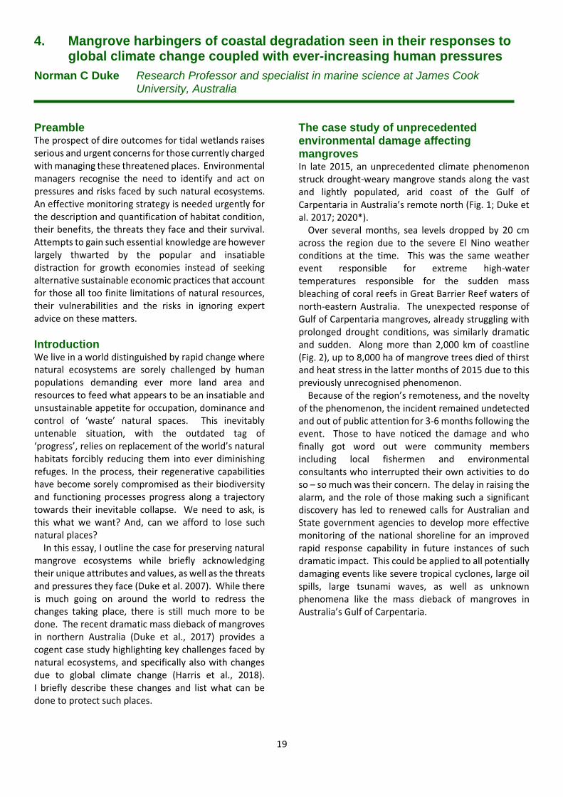
The case study of unprecedented environmental damage affecting mangroves In late 2015, an unprecedented climate phenomenon struck drought-weary mangrove stands along the vast and lightly populated, arid coast of the Gulf of Carpentaria in Australia’s remote north (Fig. 1; Duke et al. 2017; 2020*). Over several months, sea levels dropped by 20 cm across the region due to the severe El Nino weather conditions at the time. This was the same weather event responsible for extreme high-water temperatures responsible for the sudden mass bleaching of coral reefs in Great Barrier Reef waters of north-eastern Australia. The unexpected response of Gulf of Carpentaria mangroves, already struggling with prolonged drought conditions, was similarly dramatic and sudden. Along more than 2,000 km of coastline (Fig. 2), up to 8,000 ha of mangrove trees died of thirst and heat stress in the latter months of 2015 due to this previously unrecognised phenomenon. Because of the region’s remoteness, and the novelty of the phenomenon, the incident remained undetected and out of public attention for 3-6 months following the event. Those to have noticed the damage and who finally got word out were community members including local fishermen and environmental consultants who interrupted their own activities to do so – so much was their concern. The delay in raising the alarm, and the role of those making such a significant discovery has led to renewed calls for Australian and State government agencies to develop more effective monitoring of the national shoreline for an improved rapid response capability in future instances of such dramatic impact. This could be applied to all potentially damaging events like severe tropical cyclones, large oil spills, large tsunami waves, as well as unknown phenomena like the mass dieback of mangroves in Australia’s Gulf of Carpentaria.
20
Knowledge of individual mangrove plant distributions and the physical factors influencing them Where mangroves are known to defend erosion-prone shorelines (Fig. 3), it is critical to know something about these unique plants. Mangroves have been around for more than 50 million years (Duke 2017) – along with their unique combination of capabilities for dealing with salty water and regularly inundated soils (Duke 2006). These defining features evolved long ago independently in up to 20 different plant families. This makes it tricky to define exactly what specific plants can be called mangroves, and what are not. Each family re-invented the capabilities needed to achieve the necessary ecosystem functions in sometimes quite different ways. While mangrove plants sometimes share a number of features, like the bearing of live young (vivipary), the ability to excrete salt from specially adapted pores on leaves, special exposed air breathing root structures either emergent from sub-soil roots or as aerial roots coming down from high
branches, and as notably buoyant propagules, they each have their own unique combination of this assortment of specialised features and more. For example, the mangrove palm Nypa is a rare and unusual palm with a uniquely buried rhizome-like trunk that grows under the mud. Another mangrove, called the keeled pod mangrove Heritiera, has a large buoyant seed capsule shaped like a small boat complete with sail for effective dispersal. Other mangroves, the stilt root mangrove Rhizophora, have long bean-shaped buoyant propagules germinated on the parent tree and ready for long distance dispersal with plenty of provided food for the journey. The combination of these amazing but sometimes unrelated and very different plants adds to some confusion with the definition. So, the defining features largely come down to whether the specific plants are dedicated inhabitants of the upper tidal wetland niche between mean sea level and highest tide levels. But this creates another challenge with the definition since
Fig. 1. In late 2015 mass dieback of mangrove forests occurred in Australia’s Gulf of
Carpentaria. These photographs show the dead shoreline three and four years after
(Limmen Bight, Northern Territory). Note the loss of standing dead trees in 2019
scoured by Tropical Cyclone Owen (a cat. 3 cyclone) six months earlier. The inset shows
the extent of shoreline impacted by the mass dieback and the image location. Images:
N.C. Duke.
Fig. 2. Aerial views of seaward mangrove fringes showing foreshore sections of minor damage
(left photo) and extreme dieback (right photo) observed in June 2016 between Limmen Bight
River and McArthur River, Northern Territory. These could easily represent before and after
scenarios, but infact shows how some shoreline sections were left exposed and vulnerable
while others were left intact with relatively minor damage at the back of the fringe. Images:
N.C. Duke.
21
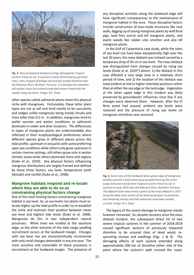
Fig. 3. View of seaward mangrove fringe damaged by Tropical
Cyclone Trevor (a cat. 4 cyclone) in early 2019 showing uprooted
trees, trees stripped of foliage and severely eroded shoreline near
the Robinson River, Northern Territory. It is doubtful this shoreline
will recover insitu but instead erode and retreat inland with the
rapidly rising sea levels. Image: N.C. Duke.
other species called saltmarsh plants share this physical niche with mangroves. Fortunately, these latter plant types are not as tall and tend mostly to be succulents and sedges unlike mangroves being mostly shrubs and trees taller than 0.5 m. In addition, mangroves tend to prefer warmer and wetter conditions so saltmarsh dominate in colder and drier locations. The differences in types of mangrove plants are understandably also reflected in their ecophysiological preferences where different species grow in different places across the tidal profile, upstream in estuaries with some preferring open sea conditions while others only grow upstream in certain riverine settings, still others grow only in wetter climatic zones while others dominate more arid regions (Duke et al., 2019). Key physical factors influencing mangrove distributions are largely framed and defined by these three factors, sea level, temperature (with latitude) and rainfall (Duke et al., 1998).
Mangrove habitats respond and re-locate where they are able to do so as constraining physical factors change One of the most limiting factors constraining mangrove habitat is sea level. So, as sea levels rise plants must re-locate higher up the tidal profile in order to re-establish the niche and maintain their position between mean sea level and highest tide levels (Duke et al. 1998). Mangroves do this in two independent natural processes. While trees are eroded at the seashore edge, at the other extreme of the tidal range seedling recruitment occurs at the landward margin. Changes with sea level rise are characteristically incremental with only small changes detectable in any one year. The most sensitive and vulnerable of these processes is recruitment at the landward margin. The presence of
any disruptive activities along the landward edge will have significant consequences to the maintenance of mangrove habitat in the area. These disruptive factors include construction of man-made structures like rock walls, digging up of young mangrove plants by wild feral pigs, land fires scorch and kill mangrove plants, and exotic weeds like rubber vine smother and also kill mangrove plants. In the Gulf of Carpentaria case study, while the rates of sea level rise have been exceptionally high over the last 30 years, the mass dieback was instead caused by a temporary drop of 20 cm in sea level. The mass dieback was distinguished from changes caused by rising sea levels (Duke et al. 2020*) where: 1) the dieback in this case affected a very large area in a relatively short period of time, and 2) the location of the dieback was most evident at mid to higher intertidal positions rather than at either the sea edge or the land edge. Vegetation at the latter upper edge in this incident was likely preserved by groundwater influences since few if any changes were observed there. However, after the El Nino event had passed, ambient sea levels were restored and the pressure of rising sea levels on mangrove shorelines was resumed.
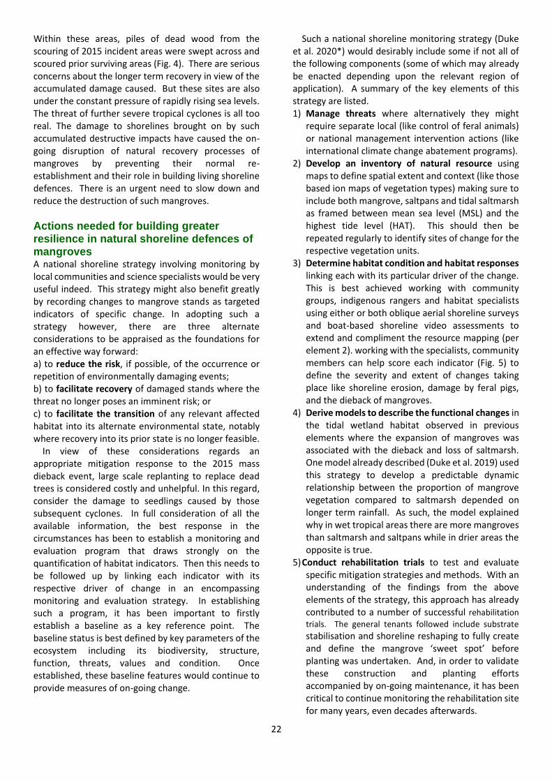
Fig. 4. Aerial view of the landward dense green edge of mangroves
notably covered in piled dead wood dumped there by the storm
surge and severe winds from Tropical Cyclone Trevor (a cat. 4
cyclone) in early 2019 near the Robinson River, Northern Territory.
The adjacent bare area marks a patch of the mass dieback in 2015
being the likely main source of the dead wood given its proximity,
the remaining stumps and that sediments have been notably
scoured. Image: N.C. Duke.
The legacy of the severe damage to mangrove stands however remained. So, despite recovery since the mass dieback incident, the subsequent direct hit of two severe tropical cyclones in the summer of 2018-2019 caused significant sections of previously impacted shoreline to be scoured clear of dead wood, re-sprouting stumps and seedlings (Figs. 1 & 4). The damaging effects of each cyclone extended along approximately 200 km of shoreline either side of the point where the cyclone’s path crossed the coast.
22
Within these areas, piles of dead wood from the scouring of 2015 incident areas were swept across and scoured prior surviving areas (Fig. 4). There are serious concerns about the longer term recovery in view of the accumulated damage caused. But these sites are also under the constant pressure of rapidly rising sea levels. The threat of further severe tropical cyclones is all too real. The damage to shorelines brought on by such accumulated destructive impacts have caused the on-going disruption of natural recovery processes of mangroves by preventing their normal re-establishment and their role in building living shoreline defences. There is an urgent need to slow down and reduce the destruction of such mangroves.
Actions needed for building greater resilience in natural shoreline defences of mangroves A national shoreline strategy involving monitoring by local communities and science specialists would be very useful indeed. This strategy might also benefit greatly by recording changes to mangrove stands as targeted indicators of specific change. In adopting such a strategy however, there are three alternate considerations to be appraised as the foundations for an effective way forward: a) to reduce the risk, if possible, of the occurrence or repetition of environmentally damaging events; b) to facilitate recovery of damaged stands where the threat no longer poses an imminent risk; or c) to facilitate the transition of any relevant affected habitat into its alternate environmental state, notably where recovery into its prior state is no longer feasible. In view of these considerations regards an appropriate mitigation response to the 2015 mass dieback event, large scale replanting to replace dead trees is considered costly and unhelpful. In this regard, consider the damage to seedlings caused by those subsequent cyclones. In full consideration of all the available information, the best response in the circumstances has been to establish a monitoring and evaluation program that draws strongly on the quantification of habitat indicators. Then this needs to be followed up by linking each indicator with its respective driver of change in an encompassing monitoring and evaluation strategy. In establishing such a program, it has been important to firstly establish a baseline as a key reference point. The baseline status is best defined by key parameters of the ecosystem including its biodiversity, structure, function, threats, values and condition. Once established, these baseline features would continue to provide measures of on-going change.
Such a national shoreline monitoring strategy (Duke et al. 2020*) would desirably include some if not all of the following components (some of which may already be enacted depending upon the relevant region of application). A summary of the key elements of this strategy are listed. 1) Manage threats where alternatively they might
require separate local (like control of feral animals) or national management intervention actions (like international climate change abatement programs).
2) Develop an inventory of natural resource using maps to define spatial extent and context (like those based ion maps of vegetation types) making sure to include both mangrove, saltpans and tidal saltmarsh as framed between mean sea level (MSL) and the highest tide level (HAT). This should then be repeated regularly to identify sites of change for the respective vegetation units.
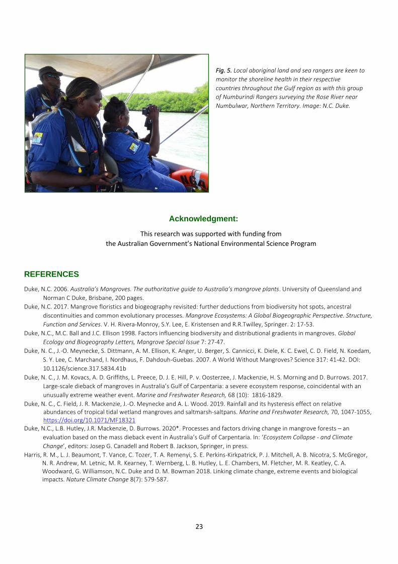
3) Determine habitat condition and habitat responses linking each with its particular driver of the change. This is best achieved working with community groups, indigenous rangers and habitat specialists using either or both oblique aerial shoreline surveys and boat-based shoreline video assessments to extend and compliment the resource mapping (per element 2). working with the specialists, community members can help score each indicator (Fig. 5) to define the severity and extent of changes taking place like shoreline erosion, damage by feral pigs, and the dieback of mangroves.
4) Derive models to describe the functional changes in the tidal wetland habitat observed in previous elements where the expansion of mangroves was associated with the dieback and loss of saltmarsh. One model already described (Duke et al. 2019) used this strategy to develop a predictable dynamic relationship between the proportion of mangrove vegetation compared to saltmarsh depended on longer term rainfall. As such, the model explained why in wet tropical areas there are more mangroves than saltmarsh and saltpans while in drier areas the opposite is true.
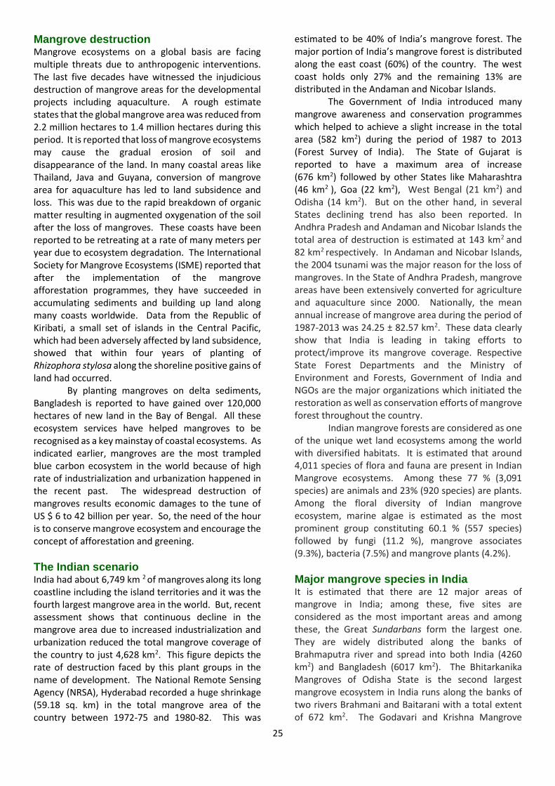
5) Conduct rehabilitation trials to test and evaluate specific mitigation strategies and methods. With an understanding of the findings from the above elements of the strategy, this approach has already contributed to a number of successful rehabilitation
trials. The general tenants followed include substrate
stabilisation and shoreline reshaping to fully create and define the mangrove ‘sweet spot’ before planting was undertaken. And, in order to validate these construction and planting efforts accompanied by on-going maintenance, it has been critical to continue monitoring the rehabilitation site for many years, even decades afterwards.
23
Acknowledgment:
This research was supported with funding from
the Australian Government’s National Environmental Science Program
REFERENCES
Duke, N.C. 2006. Australia’s Mangroves. The authoritative guide to Australia’s mangrove plants. University of Queensland and
Norman C Duke, Brisbane, 200 pages.
Duke, N.C. 2017. Mangrove floristics and biogeography revisited: further deductions from biodiversity hot spots, ancestral
discontinuities and common evolutionary processes. Mangrove Ecosystems: A Global Biogeographic Perspective. Structure,
Function and Services. V. H. Rivera-Monroy, S.Y. Lee, E. Kristensen and R.R.Twilley, Springer. 2: 17-53.
Duke, N.C., M.C. Ball and J.C. Ellison 1998. Factors influencing biodiversity and distributional gradients in mangroves. Global
Ecology and Biogeography Letters, Mangrove Special Issue 7: 27-47.
Duke, N. C., J.-O. Meynecke, S. Dittmann, A. M. Ellison, K. Anger, U. Berger, S. Cannicci, K. Diele, K. C. Ewel, C. D. Field, N. Koedam,
S. Y. Lee, C. Marchand, I. Nordhaus, F. Dahdouh-Guebas. 2007. A World Without Mangroves? Science 317: 41-42. DOI:
10.1126/science.317.5834.41b
Duke, N. C., J. M. Kovacs, A. D. Griffiths, L. Preece, D. J. E. Hill, P. v. Oosterzee, J. Mackenzie, H. S. Morning and D. Burrows. 2017.
Large-scale dieback of mangroves in Australia’s Gulf of Carpentaria: a severe ecosystem response, coincidental with an
unusually extreme weather event. Marine and Freshwater Research, 68 (10): 1816-1829.
Duke, N. C., C. Field, J. R. Mackenzie, J.-O. Meynecke and A. L. Wood. 2019. Rainfall and its hysteresis effect on relative abundances of tropical tidal wetland mangroves and saltmarsh-saltpans. Marine and Freshwater Research, 70, 1047-1055, https://doi.org/10.1071/MF18321
Duke, N.C., L.B. Hutley, J.R. Mackenzie, D. Burrows. 2020*. Processes and factors driving change in mangrove forests – an
evaluation based on the mass dieback event in Australia’s Gulf of Carpentaria. In: ‘Ecosystem Collapse - and Climate
Change’, editors: Josep G. Canadell and Robert B. Jackson, Springer, in press.
Harris, R. M., L. J. Beaumont, T. Vance, C. Tozer, T. A. Remenyi, S. E. Perkins-Kirkpatrick, P. J. Mitchell, A. B. Nicotra, S. McGregor, N. R. Andrew, M. Letnic, M. R. Kearney, T. Wernberg, L. B. Hutley, L. E. Chambers, M. Fletcher, M. R. Keatley, C. A. Woodward, G. Williamson, N.C. Duke and D. M. Bowman 2018. Linking climate change, extreme events and biological impacts. Nature Climate Change 8(7): 579-587.
Fig. 5. Local aboriginal land and sea rangers are keen to
monitor the shoreline health in their respective
countries throughout the Gulf region as with this group
of Numburindi Rangers surveying the Rose River near
Numbulwar, Northern Territory. Image: N.C. Duke.
24
5. Mangrove ecosystem and coastal livelihood with special reference to Indian scenario
Dinesh Kaippilly, Geeji M. Tharanath and E. R. Chinchu. Department of Aquaculture, Kerala University of Fisheries and Ocean Studies (KUFOS), Panangad PO, Cochin, Kerala, India-682 506. [email protected]
Introduction Mangroves belong to a special group of salt tolerant plants which grow mainly in the intertidal regions of tropical and sub-tropical coastline around the globe. They have special adaptations suitable for the saline and oxygen deficient living conditions. These plant groups have root adaptations like breathing roots which can absorb oxygen from the atmosphere. Mangrove ecosystems play vital roles in climate adaptation and resilience of the coastal areas by protecting the vulnerable boundaries from storm surge, sea level rise, erosion, water quality fluctuations and also facilitating nutrient recycling, sediment trapping and habitat conservation. But the most significant service provided by this ecosystem on a long term perspective is the mitigation of climate change by sequestering carbon from the atmosphere and oceans, known as blue carbon. This is the carbon stored in the soil, stems, leaves, roots and non-living biomass in mangrove areas, salt tidal marshes and sea grass. This blue carbon sequestered in coastal soils is exorbitantly high in magnitude and remains trapped for long periods resulting in large carbon stocks. Indubitably, the coastal plant communities are able to sequestrate carbon from both allochthonous (brought from outside) and autochthonous (generated internally) sources.
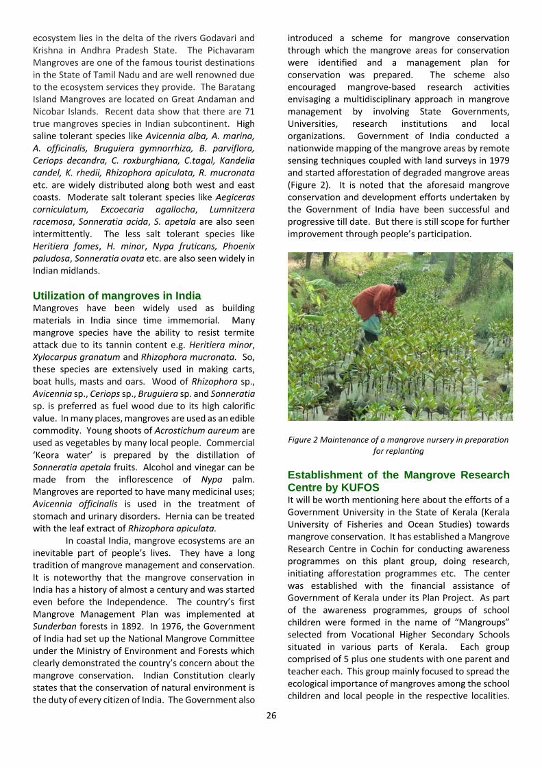
As indicated earlier, mangrove wetlands irrespective of where they occur can be clearly designated as multiple use ecosystems. It strengthens the livelihoods of millions of local people concentrated in the coastal areas and help them to earn their daily bread for nutritional security. A few species of mangroves have been identified as a rich source of common life-saving medicines. Mangroves have been also used as wood for house construction, as fire wood and also as fodder to cattle. These trees are also used for the manufacture of tannin and the collection of premium quality honey.
Mangroves and fisheries Notably, this ecosystem can enhance local fisheries by providing shelter and grazing grounds for different larval and juvenile forms of commercially important fish and shell fish species. Most of these aquatic animals are bred in the sea and the larval forms get transported through tidal inflow to interior mangrove
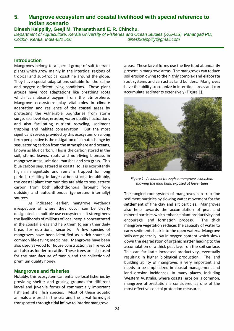
areas. These larval forms use the live food abundantly present in mangrove areas. The mangroves can reduce soil erosion owing to the highly complex and elaborate root systems and can act as land builders. Mangroves have the ability to colonize in inter tidal areas and can accumulate sediments extensively (Figure 1).
Figure 1. A channel through a mangrove ecosystem
showing the mud bank exposed at lower tides
The tangled root system of mangroves can trap fine sediment particles by slowing water movement for the settlement of fine clay and silt particles. Mangroves also help towards the accumulation of peat and mineral particles which enhance plant productivity and encourage land formation process. The thick mangrove vegetation reduces the capacity of water to carry sediments back into the open waters. Mangrove soils are generally low in oxygen content which slows down the degradation of organic matter leading to the accumulation of a thick peat layer on the soil surface. This can facilitate increased productivity, eventually resulting in higher biological production. The land building ability of mangroves is very important and needs to be emphasized in coastal management and land erosion incidences. In many places, including Western Australia, where coastal erosion is common, mangrove afforestation is considered as one of the most effective coastal protection measures.
25
Mangrove destruction Mangrove ecosystems on a global basis are facing multiple threats due to anthropogenic interventions. The last five decades have witnessed the injudicious destruction of mangrove areas for the developmental projects including aquaculture. A rough estimate states that the global mangrove area was reduced from 2.2 million hectares to 1.4 million hectares during this period. It is reported that loss of mangrove ecosystems may cause the gradual erosion of soil and disappearance of the land. In many coastal areas like Thailand, Java and Guyana, conversion of mangrove area for aquaculture has led to land subsidence and loss. This was due to the rapid breakdown of organic matter resulting in augmented oxygenation of the soil after the loss of mangroves. These coasts have been reported to be retreating at a rate of many meters per year due to ecosystem degradation. The International Society for Mangrove Ecosystems (ISME) reported that after the implementation of the mangrove afforestation programmes, they have succeeded in accumulating sediments and building up land along many coasts worldwide. Data from the Republic of Kiribati, a small set of islands in the Central Pacific, which had been adversely affected by land subsidence, showed that within four years of planting of Rhizophora stylosa along the shoreline positive gains of land had occurred.
By planting mangroves on delta sediments, Bangladesh is reported to have gained over 120,000 hectares of new land in the Bay of Bengal. All these ecosystem services have helped mangroves to be recognised as a key mainstay of coastal ecosystems. As indicated earlier, mangroves are the most trampled blue carbon ecosystem in the world because of high rate of industrialization and urbanization happened in the recent past. The widespread destruction of mangroves results economic damages to the tune of US $ 6 to 42 billion per year. So, the need of the hour is to conserve mangrove ecosystem and encourage the concept of afforestation and greening.
The Indian scenario India had about 6,749 km 2 of mangroves along its long coastline including the island territories and it was the fourth largest mangrove area in the world. But, recent assessment shows that continuous decline in the mangrove area due to increased industrialization and urbanization reduced the total mangrove coverage of the country to just 4,628 km2. This figure depicts the rate of destruction faced by this plant groups in the name of development. The National Remote Sensing Agency (NRSA), Hyderabad recorded a huge shrinkage (59.18 sq. km) in the total mangrove area of the country between 1972-75 and 1980-82. This was
estimated to be 40% of India’s mangrove forest. The major portion of India’s mangrove forest is distributed along the east coast (60%) of the country. The west coast holds only 27% and the remaining 13% are distributed in the Andaman and Nicobar Islands. The Government of India introduced many mangrove awareness and conservation programmes which helped to achieve a slight increase in the total area (582 km2) during the period of 1987 to 2013 (Forest Survey of India). The State of Gujarat is reported to have a maximum area of increase (676 km2) followed by other States like Maharashtra (46 km2 ), Goa (22 km2), West Bengal (21 km2) and Odisha (14 km2). But on the other hand, in several States declining trend has also been reported. In Andhra Pradesh and Andaman and Nicobar Islands the total area of destruction is estimated at 143 km2 and 82 km2 respectively. In Andaman and Nicobar Islands, the 2004 tsunami was the major reason for the loss of mangroves. In the State of Andhra Pradesh, mangrove areas have been extensively converted for agriculture and aquaculture since 2000. Nationally, the mean annual increase of mangrove area during the period of 1987-2013 was 24.25 ± 82.57 km2. These data clearly show that India is leading in taking efforts to protect/improve its mangrove coverage. Respective State Forest Departments and the Ministry of Environment and Forests, Government of India and NGOs are the major organizations which initiated the restoration as well as conservation efforts of mangrove forest throughout the country. Indian mangrove forests are considered as one of the unique wet land ecosystems among the world with diversified habitats. It is estimated that around 4,011 species of flora and fauna are present in Indian Mangrove ecosystems. Among these 77 % (3,091 species) are animals and 23% (920 species) are plants. Among the floral diversity of Indian mangrove ecosystem, marine algae is estimated as the most prominent group constituting 60.1 % (557 species) followed by fungi (11.2 %), mangrove associates (9.3%), bacteria (7.5%) and mangrove plants (4.2%).
Major mangrove species in India It is estimated that there are 12 major areas of mangrove in India; among these, five sites are considered as the most important areas and among these, the Great Sundarbans form the largest one. They are widely distributed along the banks of Brahmaputra river and spread into both India (4260 km2) and Bangladesh (6017 km2). The Bhitarkanika Mangroves of Odisha State is the second largest mangrove ecosystem in India runs along the banks of two rivers Brahmani and Baitarani with a total extent of 672 km2. The Godavari and Krishna Mangrove
26
ecosystem lies in the delta of the rivers Godavari and Krishna in Andhra Pradesh State. The Pichavaram Mangroves are one of the famous tourist destinations in the State of Tamil Nadu and are well renowned due to the ecosystem services they provide. The Baratang Island Mangroves are located on Great Andaman and Nicobar Islands. Recent data show that there are 71 true mangroves species in Indian subcontinent. High saline tolerant species like Avicennia alba, A. marina, A. officinalis, Bruguiera gymnorrhiza, B. parviflora, Ceriops decandra, C. roxburghiana, C.tagal, Kandelia candel, K. rhedii, Rhizophora apiculata, R. mucronata etc. are widely distributed along both west and east coasts. Moderate salt tolerant species like Aegiceras corniculatum, Excoecaria agallocha, Lumnitzera racemosa, Sonneratia acida, S. apetala are also seen intermittently. The less salt tolerant species like Heritiera fomes, H. minor, Nypa fruticans, Phoenix paludosa, Sonneratia ovata etc. are also seen widely in Indian midlands.
Utilization of mangroves in India Mangroves have been widely used as building materials in India since time immemorial. Many mangrove species have the ability to resist termite attack due to its tannin content e.g. Heritiera minor, Xylocarpus granatum and Rhizophora mucronata. So, these species are extensively used in making carts, boat hulls, masts and oars. Wood of Rhizophora sp., Avicennia sp., Ceriops sp., Bruguiera sp. and Sonneratia sp. is preferred as fuel wood due to its high calorific value. In many places, mangroves are used as an edible commodity. Young shoots of Acrostichum aureum are used as vegetables by many local people. Commercial ‘Keora water’ is prepared by the distillation of Sonneratia apetala fruits. Alcohol and vinegar can be made from the inflorescence of Nypa palm. Mangroves are reported to have many medicinal uses; Avicennia officinalis is used in the treatment of stomach and urinary disorders. Hernia can be treated with the leaf extract of Rhizophora apiculata. In coastal India, mangrove ecosystems are an inevitable part of people’s lives. They have a long tradition of mangrove management and conservation. It is noteworthy that the mangrove conservation in India has a history of almost a century and was started even before the Independence. The country’s first Mangrove Management Plan was implemented at Sunderban forests in 1892. In 1976, the Government of India had set up the National Mangrove Committee under the Ministry of Environment and Forests which clearly demonstrated the country’s concern about the mangrove conservation. Indian Constitution clearly states that the conservation of natural environment is the duty of every citizen of India. The Government also
introduced a scheme for mangrove conservation through which the mangrove areas for conservation were identified and a management plan for conservation was prepared. The scheme also encouraged mangrove-based research activities envisaging a multidisciplinary approach in mangrove management by involving State Governments, Universities, research institutions and local organizations. Government of India conducted a nationwide mapping of the mangrove areas by remote sensing techniques coupled with land surveys in 1979 and started afforestation of degraded mangrove areas (Figure 2). It is noted that the aforesaid mangrove conservation and development efforts undertaken by the Government of India have been successful and progressive till date. But there is still scope for further improvement through people’s participation.
Figure 2 Maintenance of a mangrove nursery in preparation for replanting
Establishment of the Mangrove Research Centre by KUFOS It will be worth mentioning here about the efforts of a Government University in the State of Kerala (Kerala University of Fisheries and Ocean Studies) towards mangrove conservation. It has established a Mangrove Research Centre in Cochin for conducting awareness programmes on this plant group, doing research, initiating afforestation programmes etc. The center was established with the financial assistance of Government of Kerala under its Plan Project. As part of the awareness programmes, groups of school children were formed in the name of “Mangroups” selected from Vocational Higher Secondary Schools situated in various parts of Kerala. Each group comprised of 5 plus one students with one parent and teacher each. This group mainly focused to spread the ecological importance of mangroves among the school children and local people in the respective localities.
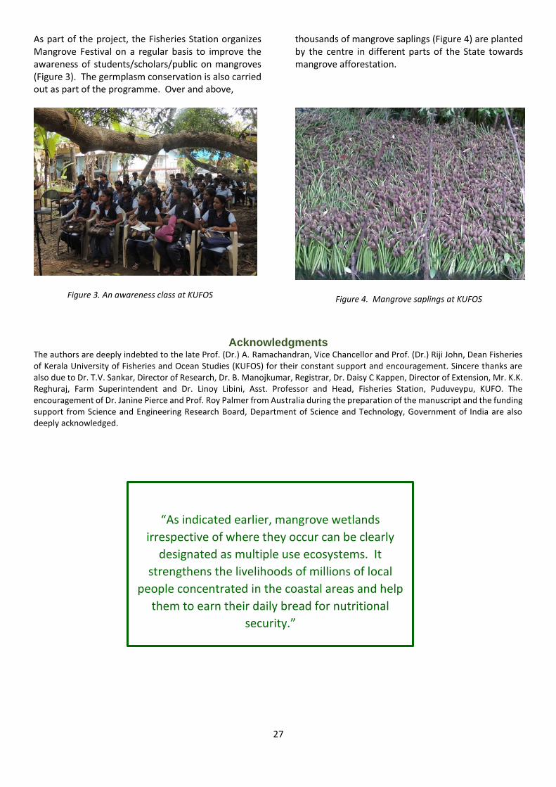
27
As part of the project, the Fisheries Station organizes Mangrove Festival on a regular basis to improve the awareness of students/scholars/public on mangroves (Figure 3). The germplasm conservation is also carried out as part of the programme. Over and above,
thousands of mangrove saplings (Figure 4) are planted by the centre in different parts of the State towards mangrove afforestation.
Figure 3. An awareness class at KUFOS
Figure 4. Mangrove saplings at KUFOS
Acknowledgments The authors are deeply indebted to the late Prof. (Dr.) A. Ramachandran, Vice Chancellor and Prof. (Dr.) Riji John, Dean Fisheries of Kerala University of Fisheries and Ocean Studies (KUFOS) for their constant support and encouragement. Sincere thanks are also due to Dr. T.V. Sankar, Director of Research, Dr. B. Manojkumar, Registrar, Dr. Daisy C Kappen, Director of Extension, Mr. K.K. Reghuraj, Farm Superintendent and Dr. Linoy Libini, Asst. Professor and Head, Fisheries Station, Puduveypu, KUFO. The encouragement of Dr. Janine Pierce and Prof. Roy Palmer from Australia during the preparation of the manuscript and the funding support from Science and Engineering Research Board, Department of Science and Technology, Government of India are also deeply acknowledged.
“As indicated earlier, mangrove wetlands
irrespective of where they occur can be clearly
designated as multiple use ecosystems. It
strengthens the livelihoods of millions of local
people concentrated in the coastal areas and help
them to earn their daily bread for nutritional
security.”
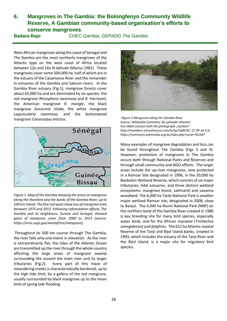
28
6. Mangroves in The Gambia: the Bolongfenyo Community Wildlife
Reserve, A Gambian community-based organisation’s efforts to
conserve mangroves. Badara Bajo CHEC Gambia, GEPADG The Gambia
West African mangroves along the coast of Senegal and The Gambia are the most northerly mangroves of the Atlantic type on the west coast of Africa located between 12o and 16o N latitude (Marius 1981). These mangroves cover some 500,000 ha, half of which are in the estuary of the Casamance River and the remainder in estuaries of the Gambia and Saloum rivers. In the Gambia River estuary (Fig.1), mangrove forests cover about 65,000 ha and are dominated by six species: the red mangrove Rhizophora racemosa and R. harrisonii, the American mangrove R. mangle, the black mangrove Avicennia nitida, the white mangrove Laguncularia racemosa, and the buttonwood mangrove Conocarpus erectus.
Figure 1. Map of the Gambia showing the areas on mangrove along the shoreline and the banks of the Gambia River, up to 100 km inland. The few red spots show loss of mangrove area between 1975 and 2013. Following reforestation efforts, The Gambia and its neighbours, Guinea and Senegal, showed gains of mangrove cover from 2000 to 2013 (source: https://eros.usgs.gov/westafrica/mangrove). Throughout its 500 km course through The Gambia, the river falls only one metre in elevation. As the river is extraordinarily flat, the tides of the Atlantic Ocean are transmitted up the river through the whole country affecting the large areas of mangrove swamp surrounding the around the main river and its larger tributaries (Fig.2). Every part of this maze of meandering creeks is characteristically bordered, up to the high tide limit, by a gallery of the red mangrove, usually surrounded by black mangrove up to the mean limit of spring tide flooding.
Figure 2 Mangroves along the Gambia River Source: Wikipedia Commons: By uploader Atamari has eMail-contact with the photograph „sachara“ - http://members.virtualtourist.com/m/tp/10d67b/, CC BY-SA 3.0, https://commons.wikimedia.org/w/index.php?curid=761047
Many examples of mangrove degradation and loss can be found throughout The Gambia (Figs 3 and 4). However, protection of mangroves in The Gambia occurs both through National Parks and Reserves and through small community and NGO efforts. The larger areas include the up-river mangroves, now protected in a Ramsar Site designated in 1996, in the 20,000 ha Baobolon Wetland Reserve, which consists of six major tributaries, tidal estuaries, and three distinct wetland ecosystems: mangrove forest, saltmarsh and savanna woodland. The 6,000 ha Tanbi National Park is another major wetland Ramsar site, designated in 2008, close to Banjul. The 4,940 ha Niumi National Park (NNP) on the northern bank of the Gambia River created in 1986 is key breeding site for many bird species, especially water birds, and for the African manatee (Trichechus senegalensis) and dolphins. The 612 ha Atlantic coastal Reserve of the Tanji and Bijol Island banks, created in 1993, which includes the estuary of the Tanji River and the Bijol Island, is a major site for migratory bird species.
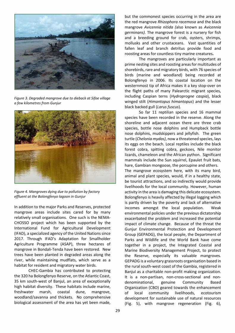
29
Figure 3. Degraded mangrove due to dieback at Sifoe village a few kilometres from Gunjur
Figure 4. Mangroves dying due to pollution by factory effluent at the Bolongfenyo lagoon in Gunjur In addition to the major Parks and Reserves, protected mangrove areas include sites cared for by many relatively small organisations. One such is the NEMA-CHOSSO project which has been supported by the International Fund for Agricultural Development (IFAD), a specialized agency of the United Nations since 2017. Through IFAD’s Adaptation for Smallholder Agriculture Programme (ASAP), three hectares of mangrove in Bondali-Tenda have been restored. New trees have been planted in degraded areas along the river, while maintaining mudflats, which serve as a habitat for resident and migratory water birds.
CHEC-Gambia has contributed to protecting the 320 ha Bolongfenyo Reserve, on the Atlantic Coast, 35 km south-west of Banjul, an area of exceptionally high habitat diversity. These habitats include marine, freshwater marsh, coastal dune, mangrove, woodland/savanna and thickets. No comprehensive biological assessment of the area has yet been made,
but the commonest species occurring in the area are the red mangrove Rhizophora racemosa and the black mangrove Avicennia nitida (also known as Avicennia germinans). The mangrove forest is a nursery for fish and a breeding ground for crab, oysters, shrimps, mollusks and other crustaceans. Vast quantities of fallen leaf and branch detritus provide food and roosting areas for countless tiny marine creatures.
The mangroves are particularly important as prime nesting sites and roosting areas for multitudes of shorebirds, rare and migratory birds, with 76 species of birds (marine and woodland) being recorded at Bolongfenyo in 2006. Its coastal location on the westernmost tip of Africa makes it a key stop-over on the flight paths of many Palearctic migrant species, including Caspian terns (Hydroprogne caspia), black winged stilt (Himantopus himantopus) and the lesser black backed gull (Larus fuscus).
So far 11 reptilian species and 16 mammal species have been recorded in the reserve. Along the shoreline and adjacent ocean there are three crab species, bottle nose dolphins and Humpback bottle nose dolphins, mudskippers and jellyfish. The green turtle (Chelonia mydas), now a threatened species, lays its eggs on the beach. Local reptiles include the black forest cobra, spitting cobra, geckoes, Nile monitor lizards, chameleon and the African python. Significant mammals include the Sun squirrel, Epaulet fruit bats, hare, Gambian mongoose, the porcupine and others. The mangrove ecosystem here, with its many bird, animal and plant species, would, if in a healthy state, be tourist attractions, and so indirectly would provide livelihoods for the local community. However, human activity in the area is damaging this delicate ecosystem. Bolongfenyo is heavily affected by illegal logging which is partly driven by the poverty and lack of alternative incomes amongst the local population. Weak environmental policies under the previous dictatorship exacerbated the problem and increased the potential impact of climate change. Because of the threat the Gunjur Environmental Protection and Development Group (GEPADG), the local people, the Department of Parks and Wildlife and the World Bank have come together in a project, the Integrated Coastal and Marine Biodiversity Management Project, to protect the Reserve, especially its valuable mangroves. GEPADG is a voluntary grassroots organisation based in the rural south-west coast of the Gambia, registered in Banjul as a charitable non-profit making organization. It is a non-partisan, non-cross-sectional and non-denominational, genuine Community Based Organization (CBO) geared towards the enhancement of local community livelihoods, ecotourism development for sustainable use of natural resources (Fig. 5), with mangrove regeneration (Fig. 6),
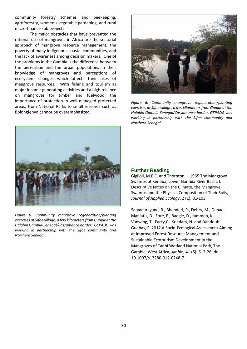
30
community forestry schemes and beekeeping, agroforestry, women’s vegetable gardening, and rural micro-finance sub projects.
The major obstacles that have prevented the rational use of mangroves in Africa are the sectorial approach of mangrove resource management, the poverty of many indigenous coastal communities, and the lack of awareness among decision makers. One of the problems in the Gambia is the difference between the peri-urban and the urban populations in their knowledge of mangroves and perceptions of ecosystem changes which affects their uses of mangrove resources. With fishing and tourism as major income-generating activities and a high reliance on mangroves for timber and fuelwood, the importance of protection in well managed protected areas, from National Parks to small reserves such as Bolongfenyo cannot be overemphasized.
Figure 6. Community mangrove regeneration/planting exercises at Sifoe village, a few kilometers from Gunjur at the Halahin Gambia-Senegal/Cassamance border. GEPADG was working in partnership with the Sifoe community and Northern Senegal.
Figure 6. Community mangrove regeneration/planting exercises at Sifoe village, a few kilometers from Gunjur at the Halahin Gambia-Senegal/Cassamance border. GEPADG was working in partnership with the Sifoe community and Northern Senegal.
Further Reading Giglioli, M.E.C. and Thornton, I. 1965 The Mangrove Swamps of Keneba, Lower Gambia River Basin. I. Descriptive Notes on the Climate, the Mangrove Swamps and the Physical Composition of Their Soils, Journal of Applied Ecology, 2 (1): 81-103.
Satyanarayana, B., Bhanderi, P., Debry, M., Danae
Maniatis, D., Foré, F., Badgie, D., Jammeh, K.,
Vanwing, T., Farcy,C., Koedam, N. and Dahdouh-
Guebas, F. 2012 A Socio-Ecological Assessment Aiming
at Improved Forest Resource Management and
Sustainable Ecotourism Development in the
Mangroves of Tanbi Wetland National Park, The
Gambia, West Africa, Ambio, 41 (5): 513-26, doi:
10.1007/s13280-012-0248-7.
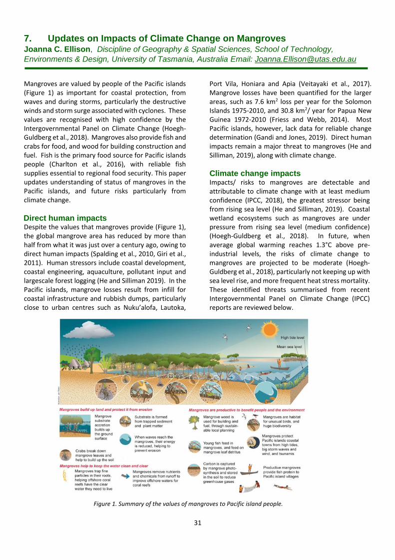
31
7. Updates on Impacts of Climate Change on Mangroves Joanna C. Ellison, Discipline of Geography & Spatial Sciences, School of Technology,
Environments & Design, University of Tasmania, Australia Email: [email protected]
Mangroves are valued by people of the Pacific islands (Figure 1) as important for coastal protection, from waves and during storms, particularly the destructive winds and storm surge associated with cyclones. These values are recognised with high confidence by the Intergovernmental Panel on Climate Change (Hoegh-Guldberg et al., 2018). Mangroves also provide fish and crabs for food, and wood for building construction and fuel. Fish is the primary food source for Pacific islands people (Charlton et al., 2016), with reliable fish supplies essential to regional food security. This paper updates understanding of status of mangroves in the Pacific islands, and future risks particularly from climate change.
Direct human impacts Despite the values that mangroves provide (Figure 1), the global mangrove area has reduced by more than half from what it was just over a century ago, owing to direct human impacts (Spalding et al., 2010, Giri et al., 2011). Human stressors include coastal development, coastal engineering, aquaculture, pollutant input and largescale forest logging (He and Silliman 2019). In the Pacific islands, mangrove losses result from infill for coastal infrastructure and rubbish dumps, particularly close to urban centres such as Nuku’alofa, Lautoka,
Port Vila, Honiara and Apia (Veitayaki et al., 2017). Mangrove losses have been quantified for the larger areas, such as 7.6 km2 loss per year for the Solomon Islands 1975-2010, and 30.8 km2/ year for Papua New Guinea 1972-2010 (Friess and Webb, 2014). Most Pacific islands, however, lack data for reliable change determination (Gandi and Jones, 2019). Direct human impacts remain a major threat to mangroves (He and Silliman, 2019), along with climate change.
Climate change impacts Impacts/ risks to mangroves are detectable and attributable to climate change with at least medium confidence (IPCC, 2018), the greatest stressor being from rising sea level (He and Silliman, 2019). Coastal wetland ecosystems such as mangroves are under pressure from rising sea level (medium confidence) (Hoegh-Guldberg et al., 2018). In future, when average global warming reaches 1.3°C above pre-industrial levels, the risks of climate change to mangroves are projected to be moderate (Hoegh-Guldberg et al., 2018), particularly not keeping up with sea level rise, and more frequent heat stress mortality. These identified threats summarised from recent Intergovernmental Panel on Climate Change (IPCC) reports are reviewed below.
Figure 1. Summary of the values of mangroves to Pacific island people.
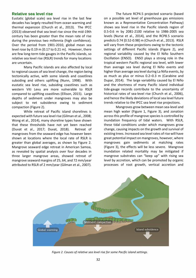
32
Relative sea level rise Eustatic (global scale) sea level rise in the last few decades has largely resulted from ocean warming and thermal expansion (Church et al., 2013). The IPCC (2013) observed that sea level rise since the mid-19th century has been greater than the mean rate of rise during the previous two millennia (high confidence). Over the period from 1901-2010, global mean sea level rose by 0.19 m [0.17 to 0.21 m]. However, there are few long-term tide gauges in the Pacific islands, so relative sea level rise (RSLR) trends for many locations are uncertain.
Many Pacific islands are also affected by local to regional causes of sea level change, the region being tectonically active, with some islands and coastlines subsiding and others uplifting (Nunn, 1998). With eustatic sea level rise, subsiding coastlines such as western Viti Levu are more vulnerable to RSLR compared to uplifting coastlines (Ellison, 2015). Large depths of sediment under mangroves may also be subject to net subsidence owing to sediment compaction (Figure 2).
While retreat of Pacific island shorelines is expected with future sea level rise (Gilman et al., 2008; Wong et al., 2014), many shoreline types have shown that these thresholds have not yet been reached (Duvat et al., 2017; Duvat, 2018). Retreat of mangroves from the seaward edge has however been shown at locations where the local rate of RSLR is greater than global averages, as shown by Figure 2. Mangrove seaward edge retreat in American Samoa, as revealed by spatial analysis over four decades in three larger mangrove areas, showed retreat of mangrove seaward margins of 25, 64, and 72 mm/year attributed to RSLR of 2 mm/year (Gilman et al., 2007).
The future RCP4.5 projected scenario (based on a possible set level of greenhouse gas emissions known as a Representative Concentration Pathway) shows sea level rise in the Pacific islands region of 0.5-0.6 m by 2081-2100 relative to 1986-2005 sea levels (Nurse et al., 2014), and the RCP8.5 scenario predicts 0.74 [0.52-0.98] m (Church et al., 2013). RSLR will vary from these projections owing to the tectonic settings of different Pacific islands (Figure 2), and regional variability caused by the El Niño Southern Oscillation (ENSO). ENSO plays a strong role in the tropical western Pacific regional sea level, with lower than average sea level during El Niño events and higher than average sea level during La Niña events, by as much as plus or minus 0.2–0.3 m (Carabine and Dupar, 2014). The large variability caused by El Niño and the shortness of many Pacific island individual tide-gauge records contribute to the uncertainty of historical rates of sea-level rise (Church et al., 2006), and hence the likely deviations of local sea level future trends relative to the IPCC sea level rise projections.
Mangroves grow between mean sea-level and mean high water (Figure 1, Figure 3), and zonation across this profile of mangrove species is controlled by inundation frequency of tidal waters. With RSLR, these tidal conditions under which mangroves grow change, causing impacts on the growth and survival of existing trees. Increased sea level rates of rise will have great potential impact on mangroves, however, where mangroves gain sediments at matching rates (Figure 3), the effects will be less severe. Mangrove inundation related mortality may be mitigated if mangrove substrates can “keep up” with rising sea level by accretion, which can be promoted by organic processes of root growth, vertical accretion and
Figure 2. Causes of relative sea level rise for some Pacific island settings.

33
sediment trapping (Figure 3). However, mangroves with low tidal range and low sediment supply could be submerged as early as 2070, including northern Papua New Guinea and the Solomon Islands (Lovelock et al., 2015).
The Pacific islands region is micro-tidal, with tidal ranges mostly around 1 m, which causes their mangroves to have greater vulnerability to sea level rise than do macro-tidal mangroves (Ellison, 2015). For example, assuming zero accretion, a 0.5 m sea level rise in a 1 m tidal range requires a 100% mangrove habitat relocation, but only 50% habitat relocation in a 4 m tidal range. Mangrove migration inland is possible, but in reality, this involves mortality at current locations, and successful establishment of new trees from seeds at higher elevations, if suitable habitats exist and are not blocked by human infrastructure such as coastal roads. Some literature using the term “inland migration” may underestimate the disruption and uncertainties in timeframes that these processes involve for trees, relative to people. Mangrove species of the landward margin are particularly vulnerable to sea-level rise if recruitment inland is restricted (Hoegh-Guldberg et al., 2018) owing to coastal development or topography (Gilman et al., 2007; Di Nitto et al., 2008), causing their habitat to be squeezed as more seaward mangroves recruit into the landward zone.
Mangrove species in the Pacific that occur at the landward edge, or upstream in tidal estuaries include Xylocarpus granatum, Excoecaria agallocha, Lumnitzera littorea, Sonneratia caseolaris and Nypa fruticans, which are likely more vulnerable than seaward edge species such as Rhizophora stylosa and Rhizophora samoensis.
Warmer temperatures and precipitation changes Atmospheric CO2 concentrations have increased at about 2 ppm/ year over the last decade, at increased rates relative to previous decades (IPCC, 2013). Increased CO2 enhances the growth of mangrove trees (Wong et al., 2013), being a reactant in photosynthesis. Mangrove responses to increasing atmospheric CO2 will be complex (Alongi, 2015), benefitting some species, while others show little change or decline. However, no research has been carried out in the Pacific islands. All Pacific islands have a different complement of mangrove species (Ellison, 2009), leading to different community responses in each country and territory.
Mangroves have a high tolerance to heat stress relative to other plants, and the IPCC projected temperature increases are below those known to cause detrimental effects (Gilman et al., 2008; Ellison & Cannicci, 2016). However, decreased rainfall will
Figure 3. Processes influencing surface elevation change in mangroves (adapted from Ellison, 2019).
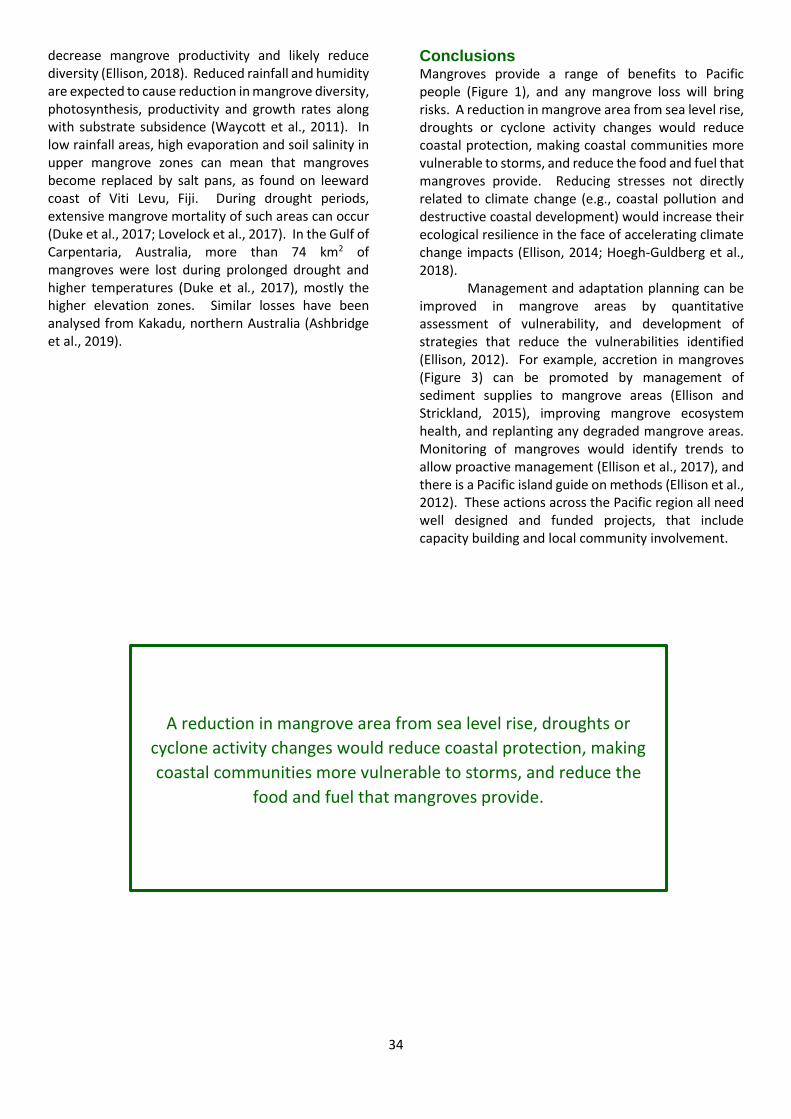
34
decrease mangrove productivity and likely reduce diversity (Ellison, 2018). Reduced rainfall and humidity are expected to cause reduction in mangrove diversity, photosynthesis, productivity and growth rates along with substrate subsidence (Waycott et al., 2011). In low rainfall areas, high evaporation and soil salinity in upper mangrove zones can mean that mangroves become replaced by salt pans, as found on leeward coast of Viti Levu, Fiji. During drought periods, extensive mangrove mortality of such areas can occur (Duke et al., 2017; Lovelock et al., 2017). In the Gulf of Carpentaria, Australia, more than 74 km2 of mangroves were lost during prolonged drought and higher temperatures (Duke et al., 2017), mostly the higher elevation zones. Similar losses have been analysed from Kakadu, northern Australia (Ashbridge et al., 2019).
Conclusions Mangroves provide a range of benefits to Pacific people (Figure 1), and any mangrove loss will bring risks. A reduction in mangrove area from sea level rise, droughts or cyclone activity changes would reduce coastal protection, making coastal communities more vulnerable to storms, and reduce the food and fuel that mangroves provide. Reducing stresses not directly related to climate change (e.g., coastal pollution and destructive coastal development) would increase their ecological resilience in the face of accelerating climate change impacts (Ellison, 2014; Hoegh-Guldberg et al., 2018).
Management and adaptation planning can be improved in mangrove areas by quantitative assessment of vulnerability, and development of strategies that reduce the vulnerabilities identified (Ellison, 2012). For example, accretion in mangroves (Figure 3) can be promoted by management of sediment supplies to mangrove areas (Ellison and Strickland, 2015), improving mangrove ecosystem health, and replanting any degraded mangrove areas. Monitoring of mangroves would identify trends to allow proactive management (Ellison et al., 2017), and there is a Pacific island guide on methods (Ellison et al., 2012). These actions across the Pacific region all need well designed and funded projects, that include capacity building and local community involvement.
A reduction in mangrove area from sea level rise, droughts or
cyclone activity changes would reduce coastal protection, making
coastal communities more vulnerable to storms, and reduce the
food and fuel that mangroves provide.
35
References
Alongi, D.M., 2015. The impact of climate change on mangrove forests. Current Climate Change Reports 1, 30-39.
Asbridge, E.F., Bartolo, R., Finlayson, C.M., et al., 2019. Assessing the distribution and drivers of mangrove dieback in Kakadu National Park, northern Australia.
Estuarine, Coastal and Shelf Science 228, 106353.
Carabine, E., Dupar, M., 2014. The IPCC’s fifth assessment report: what’s in it for small island developing states? Climate & Development Knowledge Network
(CDKN), London.
Charlton, K.E., Russell, J., Gorman, E., et al., 2016. Fish, food security and health in Pacific Island countries and territories: a systematic literature review. BMC
Public Health 16(1), 285.
Church, J.A., White, N.J. and Hunter, J.R., 2006. Sea-level rise at tropical Pacific and Indian Ocean islands. Global and Planetary Change 53(3), 155-168.
Church, J.A., Clark, P.U., Cazenave, A., et al., 2013. Sea Level Change. In: Stocker, T.F., Qin, D., Plattner, et al. (eds.) Climate Change 2013: The Physical Science
Basis: Contribution of Working Group I to the Fifth Assessment Report of the Intergovernmental Panel on Climate Change. Cambridge University Press,
Cambridge, United Kingdom and New York, NY, USA, 1137-1216.
Di Nitto, D., Dahdouh-Guebas, F., Kairo, J. G., et al., 2008. Digital terrain modelling to investigate the effects of sea level rise on mangrove propagule
establishment. Marine Ecology Progress Series 356, 175-188.
Duke, N.C., Kovacs, J.M., Griffiths, A.D., et al., 2017. Large-scale dieback of mangroves in Australia’s Gulf of Carpentaria: a severe ecosystem response,
coincidental with an unusually extreme weather event. Marine and Freshwater Research 68(10), 1816-1829.
Duvat, V.K., 2019. A global assessment of atoll island planform changes over the past decades. Wiley Interdisciplinary Reviews: Climate Change 10(1), p.e557.
Duvat, V.K., Volto, N., Salmon, C., 2017. Impacts of category 5 tropical cyclone Fantala (April 2016) on Farquhar Atoll, Seychelles Islands, Indian Ocean.
Geomorphology 298, 41-62.
Ellison, J.C., 2009. Wetlands of the Pacific island region. Wetlands Ecology and Management 17, 169–206.
Ellison, J.C., 2012. Climate change vulnerability assessment and adaptation planning for mangrove systems. WWF US, Washington DC.
https://www.worldwildlife.org/publications/climate-change-vulnerability-assessment-and-adaptation-planning-for-mangrove-systems
Ellison, J.C. 2014. Climate change adaptation: Management options for mangrove areas. In: Faridah-Hanum, I., Latiff, A., Hakeem, K.R., Ozturk M. (eds.),
Mangrove Ecosystems of Asia: Status, Challenges and Management Options, Springer, New York, 391-414.
Ellison, J.C., 2015. Vulnerability assessment of mangroves to climate change and sea-level rise impacts, Wetlands Ecology and Management 23, 115-137.
https://link.springer.com/article/10.1007%2Fs11273-014-9397-8
Ellison, J.C., 2018. Effects of climate change on mangroves relevant to the Pacific Islands. Centre for Environment, Fisheries and Aquaculture Science 99-111.
https://www.gov.uk/government/publications/commonwealth-marine-economies-cme-programme-pacific-marine-climate-change-report-card-and-scientific-
reviews
Ellison, J.C., 2019. Biogeomorphology of mangroves. In: Wolanski E., Cahoon D., Perillo G.M.E. (eds.) Coastal Wetlands: an Ecosystem Integrated Approach.
Elsevier Science, Amsterdam, 687-715.
Ellison, J.C., Cannicci, S., 2016. Impacts and effects of ocean warming on mangrove species and ecosystems, In: Laffoley, D., Baxter, J.M. (eds.), Explaining Ocean
Warming: Causes, Scale, Effects and Consequences. International Union for Conservation of Nature and Natural Resources (IUCN), Gland, Switzerland, 135-146.
Ellison, J.C., Jungblut, V., Anderson, P., Slaven, C., 2012. Manual for mangrove monitoring in the Pacific Islands Region. Secretariat of the Pacific Regional
Environment Program, Apia, Samoa. https://www.sprep.org/Publications/manual-for-mangrove-monitoring-in-the-pacific-islands-region
Ellison, J.C., Mosley, A., Helman, M., 2017. Assessing atoll shoreline condition to guide community management. Ecological Indicators 75, 321-330.
http://www.sciencedirect.com/science/article/pii/S1470160X16307269
Ellison, J.C., Strickland, P., 2015. Establishing relative sea level trends where a coast lacks a long term tide gauge. Mitigation and Adaptation Strategies for Global
Change 20, 1211-1227.
Friess, D.A., Webb, E.L., 2014. Variability in mangrove change estimates and implications for the assessment of ecosystem service provision. Global Ecology and
Biogeography 23(7), 715-725.
Gandhi, S., Jones, T.G., 2019. Identifying mangrove deforestation hotspots in South Asia, Southeast Asia and Asia-Pacific. Remote Sensing 11(6), 728.
Gilman, E., Ellison, J., Coleman, R., 2007. Assessment of mangrove response to projected relative sea-level rise and recent historical reconstruction of shoreline
position. Environmental Monitoring and Assessment 124, 105-130.
Gilman, E., Ellison, J.C., Duke, N.C., et al., 2008. Threats to mangroves from climate change and adaptation options: A review. Aquatic Botany 89, 237-250.
Giri, C., Ochieng, E., Tieszen, L.L, et al., 2011. Status and distribution of mangrove forests of the world using earth observation satellite data. Global Ecology
Biogeography 20, 154–159.
He, Q., Silliman, B.R., 2019. Climate change, human impacts, and coastal ecosystems in the Anthropocene. Current Biology 29(19), R1021-R1035.
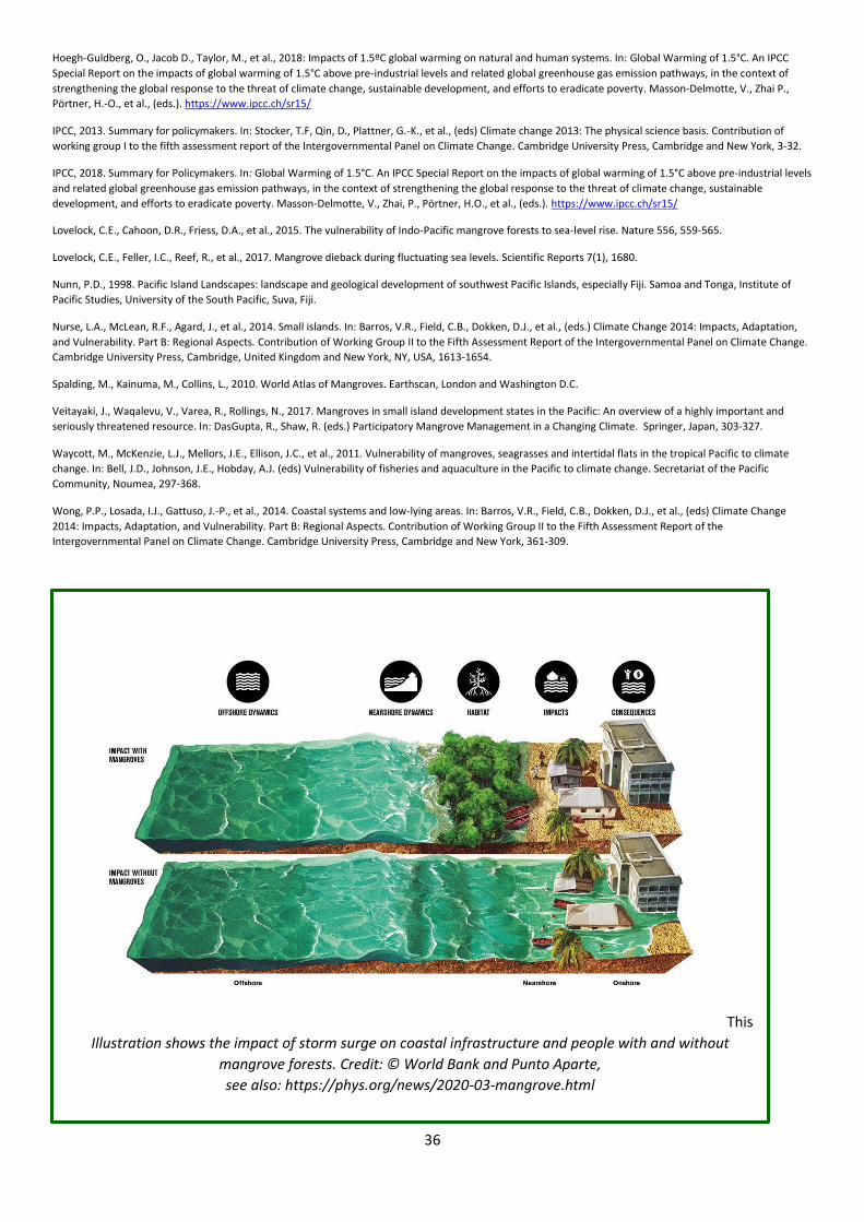
36
Hoegh-Guldberg, O., Jacob D., Taylor, M., et al., 2018: Impacts of 1.5ºC global warming on natural and human systems. In: Global Warming of 1.5°C. An IPCC
Special Report on the impacts of global warming of 1.5°C above pre-industrial levels and related global greenhouse gas emission pathways, in the context of
strengthening the global response to the threat of climate change, sustainable development, and efforts to eradicate poverty. Masson-Delmotte, V., Zhai P.,
Pörtner, H.-O., et al., (eds.). https://www.ipcc.ch/sr15/
IPCC, 2013. Summary for policymakers. In: Stocker, T.F, Qin, D., Plattner, G.-K., et al., (eds) Climate change 2013: The physical science basis. Contribution of
working group I to the fifth assessment report of the Intergovernmental Panel on Climate Change. Cambridge University Press, Cambridge and New York, 3-32.
IPCC, 2018. Summary for Policymakers. In: Global Warming of 1.5°C. An IPCC Special Report on the impacts of global warming of 1.5°C above pre-industrial levels
and related global greenhouse gas emission pathways, in the context of strengthening the global response to the threat of climate change, sustainable
development, and efforts to eradicate poverty. Masson-Delmotte, V., Zhai, P., Pörtner, H.O., et al., (eds.). https://www.ipcc.ch/sr15/
Lovelock, C.E., Cahoon, D.R., Friess, D.A., et al., 2015. The vulnerability of Indo-Pacific mangrove forests to sea-level rise. Nature 556, 559-565.
Lovelock, C.E., Feller, I.C., Reef, R., et al., 2017. Mangrove dieback during fluctuating sea levels. Scientific Reports 7(1), 1680.
Nunn, P.D., 1998. Pacific Island Landscapes: landscape and geological development of southwest Pacific Islands, especially Fiji. Samoa and Tonga, Institute of
Pacific Studies, University of the South Pacific, Suva, Fiji.
Nurse, L.A., McLean, R.F., Agard, J., et al., 2014. Small islands. In: Barros, V.R., Field, C.B., Dokken, D.J., et al., (eds.) Climate Change 2014: Impacts, Adaptation,
and Vulnerability. Part B: Regional Aspects. Contribution of Working Group II to the Fifth Assessment Report of the Intergovernmental Panel on Climate Change.
Cambridge University Press, Cambridge, United Kingdom and New York, NY, USA, 1613-1654.
Spalding, M., Kainuma, M., Collins, L., 2010. World Atlas of Mangroves. Earthscan, London and Washington D.C.
Veitayaki, J., Waqalevu, V., Varea, R., Rollings, N., 2017. Mangroves in small island development states in the Pacific: An overview of a highly important and
seriously threatened resource. In: DasGupta, R., Shaw, R. (eds.) Participatory Mangrove Management in a Changing Climate. Springer, Japan, 303-327.
Waycott, M., McKenzie, L.J., Mellors, J.E., Ellison, J.C., et al., 2011. Vulnerability of mangroves, seagrasses and intertidal flats in the tropical Pacific to climate
change. In: Bell, J.D., Johnson, J.E., Hobday, A.J. (eds) Vulnerability of fisheries and aquaculture in the Pacific to climate change. Secretariat of the Pacific
Community, Noumea, 297-368.
Wong, P.P., Losada, I.J., Gattuso, J.-P., et al., 2014. Coastal systems and low-lying areas. In: Barros, V.R., Field, C.B., Dokken, D.J., et al., (eds) Climate Change
2014: Impacts, Adaptation, and Vulnerability. Part B: Regional Aspects. Contribution of Working Group II to the Fifth Assessment Report of the
Intergovernmental Panel on Climate Change. Cambridge University Press, Cambridge and New York, 361-309.
This
Illustration shows the impact of storm surge on coastal infrastructure and people with and without
mangrove forests. Credit: © World Bank and Punto Aparte,
see also: https://phys.org/news/2020-03-mangrove.html
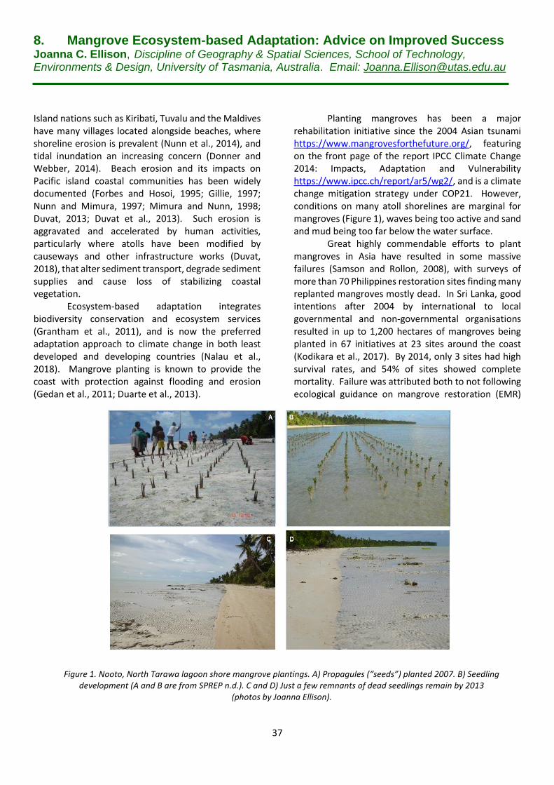
37
8. Mangrove Ecosystem-based Adaptation: Advice on Improved Success Joanna C. Ellison, Discipline of Geography & Spatial Sciences, School of Technology, Environments & Design, University of Tasmania, Australia. Email: [email protected] Island nations such as Kiribati, Tuvalu and the Maldives have many villages located alongside beaches, where shoreline erosion is prevalent (Nunn et al., 2014), and tidal inundation an increasing concern (Donner and Webber, 2014). Beach erosion and its impacts on Pacific island coastal communities has been widely documented (Forbes and Hosoi, 1995; Gillie, 1997; Nunn and Mimura, 1997; Mimura and Nunn, 1998; Duvat, 2013; Duvat et al., 2013). Such erosion is aggravated and accelerated by human activities, particularly where atolls have been modified by causeways and other infrastructure works (Duvat, 2018), that alter sediment transport, degrade sediment supplies and cause loss of stabilizing coastal vegetation.
Ecosystem-based adaptation integrates biodiversity conservation and ecosystem services (Grantham et al., 2011), and is now the preferred adaptation approach to climate change in both least developed and developing countries (Nalau et al., 2018). Mangrove planting is known to provide the coast with protection against flooding and erosion (Gedan et al., 2011; Duarte et al., 2013).
Planting mangroves has been a major
rehabilitation initiative since the 2004 Asian tsunami https://www.mangrovesforthefuture.org/, featuring on the front page of the report IPCC Climate Change 2014: Impacts, Adaptation and Vulnerability https://www.ipcc.ch/report/ar5/wg2/, and is a climate change mitigation strategy under COP21. However, conditions on many atoll shorelines are marginal for mangroves (Figure 1), waves being too active and sand and mud being too far below the water surface.
Great highly commendable efforts to plant mangroves in Asia have resulted in some massive failures (Samson and Rollon, 2008), with surveys of more than 70 Philippines restoration sites finding many replanted mangroves mostly dead. In Sri Lanka, good intentions after 2004 by international to local governmental and non-governmental organisations resulted in up to 1,200 hectares of mangroves being planted in 67 initiatives at 23 sites around the coast (Kodikara et al., 2017). By 2014, only 3 sites had high survival rates, and 54% of sites showed complete mortality. Failure was attributed both to not following ecological guidance on mangrove restoration (EMR)
Figure 1. Nooto, North Tarawa lagoon shore mangrove plantings. A) Propagules (“seeds”) planted 2007. B) Seedling development (A and B are from SPREP n.d.). C and D) Just a few remnants of dead seedlings remain by 2013
(photos by Joanna Ellison).
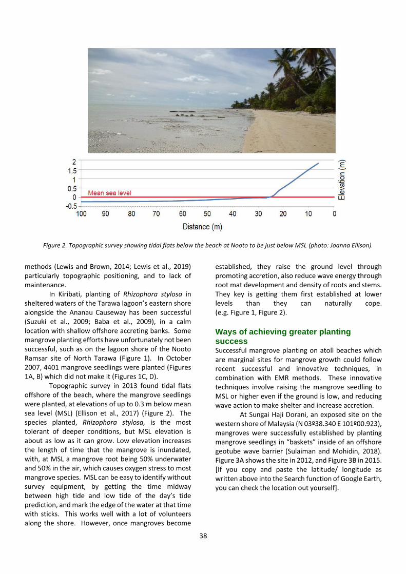
38
methods (Lewis and Brown, 2014; Lewis et al., 2019) particularly topographic positioning, and to lack of maintenance.
In Kiribati, planting of Rhizophora stylosa in sheltered waters of the Tarawa lagoon’s eastern shore alongside the Ananau Causeway has been successful (Suzuki et al., 2009; Baba et al., 2009), in a calm location with shallow offshore accreting banks. Some mangrove planting efforts have unfortunately not been successful, such as on the lagoon shore of the Nooto Ramsar site of North Tarawa (Figure 1). In October 2007, 4401 mangrove seedlings were planted (Figures 1A, B) which did not make it (Figures 1C, D).
Topographic survey in 2013 found tidal flats offshore of the beach, where the mangrove seedlings were planted, at elevations of up to 0.3 m below mean sea level (MSL) (Ellison et al., 2017) (Figure 2). The species planted, Rhizophora stylosa, is the most tolerant of deeper conditions, but MSL elevation is about as low as it can grow. Low elevation increases the length of time that the mangrove is inundated, with, at MSL a mangrove root being 50% underwater and 50% in the air, which causes oxygen stress to most mangrove species. MSL can be easy to identify without survey equipment, by getting the time midway between high tide and low tide of the day’s tide prediction, and mark the edge of the water at that time with sticks. This works well with a lot of volunteers along the shore. However, once mangroves become
established, they raise the ground level through promoting accretion, also reduce wave energy through root mat development and density of roots and stems. They key is getting them first established at lower levels than they can naturally cope. (e.g. Figure 1, Figure 2).
Ways of achieving greater planting success Successful mangrove planting on atoll beaches which are marginal sites for mangrove growth could follow recent successful and innovative techniques, in combination with EMR methods. These innovative techniques involve raising the mangrove seedling to MSL or higher even if the ground is low, and reducing wave action to make shelter and increase accretion.
At Sungai Haji Dorani, an exposed site on the western shore of Malaysia (N 03º38.340 E 101º00.923), mangroves were successfully established by planting mangrove seedlings in “baskets” inside of an offshore geotube wave barrier (Sulaiman and Mohidin, 2018). Figure 3A shows the site in 2012, and Figure 3B in 2015. [If you copy and paste the latitude/ longitude as written above into the Search function of Google Earth, you can check the location out yourself].
Figure 2. Topographic survey showing tidal flats below the beach at Nooto to be just below MSL (photo: Joanna Ellison).
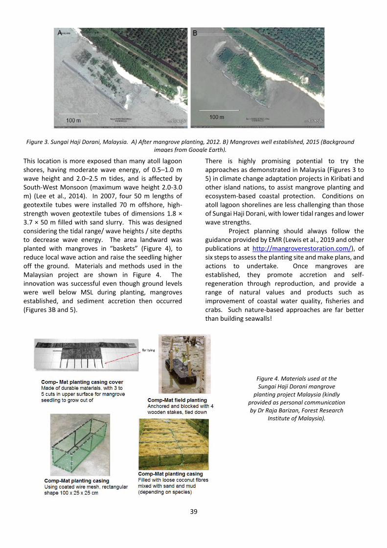
39
This location is more exposed than many atoll lagoon shores, having moderate wave energy, of 0.5–1.0 m wave height and 2.0–2.5 m tides, and is affected by South-West Monsoon (maximum wave height 2.0-3.0 m) (Lee et al., 2014). In 2007, four 50 m lengths of geotextile tubes were installed 70 m offshore, high-strength woven geotextile tubes of dimensions 1.8 × 3.7 × 50 m filled with sand slurry. This was designed considering the tidal range/ wave heights / site depths to decrease wave energy. The area landward was planted with mangroves in “baskets” (Figure 4), to reduce local wave action and raise the seedling higher off the ground. Materials and methods used in the Malaysian project are shown in Figure 4. The innovation was successful even though ground levels were well below MSL during planting, mangroves established, and sediment accretion then occurred (Figures 3B and 5).
There is highly promising potential to try the approaches as demonstrated in Malaysia (Figures 3 to 5) in climate change adaptation projects in Kiribati and other island nations, to assist mangrove planting and ecosystem-based coastal protection. Conditions on atoll lagoon shorelines are less challenging than those of Sungai Haji Dorani, with lower tidal ranges and lower wave strengths.
Project planning should always follow the guidance provided by EMR (Lewis et al., 2019 and other publications at http://mangroverestoration.com/), of six steps to assess the planting site and make plans, and actions to undertake. Once mangroves are established, they promote accretion and self- regeneration through reproduction, and provide a range of natural values and products such as improvement of coastal water quality, fisheries and crabs. Such nature-based approaches are far better than building seawalls!
Figure 3. Sungai Haji Dorani, Malaysia. A) After mangrove planting, 2012. B) Mangroves well established, 2015 (Background images from Google Earth).
Figure 4. Materials used at the Sungai Haji Dorani mangrove
planting project Malaysia (kindly provided as personal communication by Dr Raja Barizan, Forest Research
Institute of Malaysia).
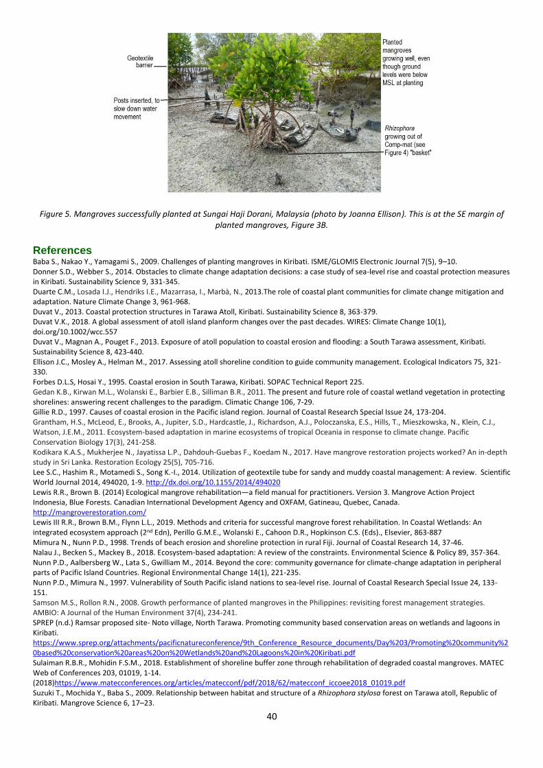
40
Figure 5. Mangroves successfully planted at Sungai Haji Dorani, Malaysia (photo by Joanna Ellison). This is at the SE margin of planted mangroves, Figure 3B.
References Baba S., Nakao Y., Yamagami S., 2009. Challenges of planting mangroves in Kiribati. ISME/GLOMIS Electronic Journal 7(5), 9–10. Donner S.D., Webber S., 2014. Obstacles to climate change adaptation decisions: a case study of sea-level rise and coastal protection measures in Kiribati. Sustainability Science 9, 331-345. Duarte C.M., Losada I.J., Hendriks I.E., Mazarrasa, I., Marbà, N., 2013.The role of coastal plant communities for climate change mitigation and adaptation. Nature Climate Change 3, 961-968. Duvat V., 2013. Coastal protection structures in Tarawa Atoll, Kiribati. Sustainability Science 8, 363-379. Duvat V.K., 2018. A global assessment of atoll island planform changes over the past decades. WIRES: Climate Change 10(1), doi.org/10.1002/wcc.557 Duvat V., Magnan A., Pouget F., 2013. Exposure of atoll population to coastal erosion and flooding: a South Tarawa assessment, Kiribati. Sustainability Science 8, 423-440. Ellison J.C., Mosley A., Helman M., 2017. Assessing atoll shoreline condition to guide community management. Ecological Indicators 75, 321-330. Forbes D.L.S, Hosai Y., 1995. Coastal erosion in South Tarawa, Kiribati. SOPAC Technical Report 225. Gedan K.B., Kirwan M.L., Wolanski E., Barbier E.B., Silliman B.R., 2011. The present and future role of coastal wetland vegetation in protecting shorelines: answering recent challenges to the paradigm. Climatic Change 106, 7-29. Gillie R.D., 1997. Causes of coastal erosion in the Pacific island region. Journal of Coastal Research Special Issue 24, 173-204. Grantham, H.S., McLeod, E., Brooks, A., Jupiter, S.D., Hardcastle, J., Richardson, A.J., Poloczanska, E.S., Hills, T., Mieszkowska, N., Klein, C.J., Watson, J.E.M., 2011. Ecosystem-based adaptation in marine ecosystems of tropical Oceania in response to climate change. Pacific Conservation Biology 17(3), 241-258. Kodikara K.A.S., Mukherjee N., Jayatissa L.P., Dahdouh‐Guebas F., Koedam N., 2017. Have mangrove restoration projects worked? An in‐depth study in Sri Lanka. Restoration Ecology 25(5), 705-716. Lee S.C., Hashim R., Motamedi S., Song K.-I., 2014. Utilization of geotextile tube for sandy and muddy coastal management: A review. Scientific World Journal 2014, 494020, 1-9. http://dx.doi.org/10.1155/2014/494020 Lewis R.R., Brown B. (2014) Ecological mangrove rehabilitation—a field manual for practitioners. Version 3. Mangrove Action Project Indonesia, Blue Forests. Canadian International Development Agency and OXFAM, Gatineau, Quebec, Canada. http://mangroverestoration.com/ Lewis III R.R., Brown B.M., Flynn L.L., 2019. Methods and criteria for successful mangrove forest rehabilitation. In Coastal Wetlands: An integrated ecosystem approach (2nd Edn), Perillo G.M.E., Wolanski E., Cahoon D.R., Hopkinson C.S. (Eds)., Elsevier, 863-887 Mimura N., Nunn P.D., 1998. Trends of beach erosion and shoreline protection in rural Fiji. Journal of Coastal Research 14, 37-46. Nalau J., Becken S., Mackey B., 2018. Ecosystem-based adaptation: A review of the constraints. Environmental Science & Policy 89, 357-364. Nunn P.D., Aalbersberg W., Lata S., Gwilliam M., 2014. Beyond the core: community governance for climate-change adaptation in peripheral parts of Pacific Island Countries. Regional Environmental Change 14(1), 221-235. Nunn P.D., Mimura N., 1997. Vulnerability of South Pacific island nations to sea-level rise. Journal of Coastal Research Special Issue 24, 133-151. Samson M.S., Rollon R.N., 2008. Growth performance of planted mangroves in the Philippines: revisiting forest management strategies. AMBIO: A Journal of the Human Environment 37(4), 234-241. SPREP (n.d.) Ramsar proposed site- Noto village, North Tarawa. Promoting community based conservation areas on wetlands and lagoons in Kiribati. https://www.sprep.org/attachments/pacificnatureconference/9th_Conference_Resource_documents/Day%203/Promoting%20community%20based%20conservation%20areas%20on%20Wetlands%20and%20Lagoons%20in%20Kiribati.pdf Sulaiman R.B.R., Mohidin F.S.M., 2018. Establishment of shoreline buffer zone through rehabilitation of degraded coastal mangroves. MATEC Web of Conferences 203, 01019, 1-14. (2018)https://www.matecconferences.org/articles/matecconf/pdf/2018/62/matecconf_iccoee2018_01019.pdf Suzuki T., Mochida Y., Baba S., 2009. Relationship between habitat and structure of a Rhizophora stylosa forest on Tarawa atoll, Republic of Kiribati. Mangrove Science 6, 17–23.
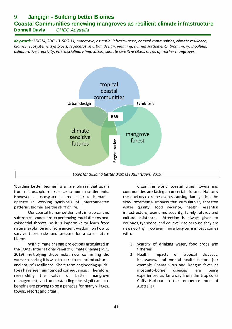
41
9. Jangigir - Building better Biomes
Coastal Communities renewing mangroves as resilient climate infrastructure Donnell Davis CHEC Australia
Keywords: SDG14, SDG 13, SDG 11, mangrove, essential infrastructure, coastal communities, climate resilience, biomes, ecosystems, symbiosis, regenerative urban design, planning, human settlements, biomimicry, Biophilia, collaborative creativity, interdisciplinary innovation, climate sensitive cities, music of mother mangroves.
‘Building better biomes’ is a rare phrase that spans from microscopic soil science to human settlements. However, all ecosystems - molecular to human - operate in working symbiosis of interconnected patterns. Biomes are the stuff of life.
Our coastal human settlements in tropical and subtropical zones are experiencing multi-dimensional existential threats, so it is imperative to learn from natural evolution and from ancient wisdom, on how to survive those risks and prepare for a safer future biome.
With climate change projections articulated in the COP25 International Panel of Climate Change (IPCC, 2019) multiplying those risks, now confirming the worst scenarios; it is wise to learn from ancient cultures and nature’s resilience. Short-term engineering quick–fixes have seen unintended consequences. Therefore, researching the value of better mangrove management, and understanding the significant co-benefits are proving to be a panacea for many villages, towns, resorts and cities.
Cross the world coastal cities, towns and communities are facing an uncertain future. Not only the obvious extreme events causing damage, but the slow incremental impacts that cumulatively threaten water quality, food security, health, essential infrastructure, economic security, family futures and cultural existence. Attention is always given to cyclones, typhoons, and ea-level-rise because they are newsworthy. However, more long-term impact comes with:
1. Scarcity of drinking water, food crops and
fisheries 2. Health impacts of tropical diseases,
heatwaves, and mental health factors (for example Bhama virus and Dengue fever as mosquito-borne diseases are being experienced as far away from the tropics as Coffs Harbour in the temperate zone of Australia)
Logic for Building Better Biomes (BBB) (Davis: 2019)
tropical coastal
communities
mangrove forest
climate sensitive futures
Urban design Symbiosis
Re
gen
era
tive
BBB
42
3. Disruption of fish hatcheries, migration patterns (along with breeding seasons of turtles, fish and birds), and sustainable marine industries (of all Pacific Islands and other small island states)
4. Inundation of crop lands that renders productive areas as useless for six months or more
5. Infiltration of salt water into freshwater systems and drinking water infrastructure, while sewage systems are collapsing
6. Migration of teenagers and young people for education and paid work (labour migration programs)
7. Loss of culture, language, and rituals, as elders stay on traditional lands (some becoming climate casualties).
What is being done to address this? In short, coastal communities are replanting and strengthening mangrove forests for several reasons:
• Protection from wind and wave erosion so providing a natural barrier against cyclones with forceful rain, whirling wind and destructive waves
• Mitigation against sea level rise by harnessing the sand, soils and silt with sprawling root systems thereby stabilising natural ecosystems
• Protection from noise of howling gales in extreme events
• Provision of microclimates for cooler, shaded coastlines
• Enriching sediment, soil and sand for a more fertile place for micro-organisms, basic benthic and estuary life upon which our higher order web of life depends
• Encouraging mosquito larvae, fish hatcheries, and food chain for humans.
How do mangroves mitigate this grim
scenario for human settlements?
Through a strong respect for symbiosis between coastal communities and mangroves, innovative urban design allows for optimising of all desirable aspects so that a pathway for a safer, fairer and sustainable future is possible. Essential natural infrastructure for healthy human settlements warrants careful consideration.
Climate sensitive futures are conceivable through regenerative principles, for urban design (town planning and land-use management), essential infrastructure investment and collaborative community creativity. To tease out these principles, let’s interrogate these singly then collectively. Each is worthy of lengthy explanation, but in short; much of
the ancient and traditional wisdom is captured in the new language. 1. Regenerative Urban Design may be founded upon
biomimicry with 3.8 billion years of evolution; ancient wisdom (maybe 65,000 year of human habitation); Biophilia (relationships of nature and humanity); eco-centric governance; collaborative interdisciplinary innovation; and practices of climate sensitive cities.
2. Essential infrastructure investment relies on well-argued options for achieving desirable outcomes to support healthy human life.
3. Collaborative community creativity relies on local knowledge, traditional knowledge, learning from cultures from other countries and places, and inviting diverse thought from different practitioners. Although engineers might think they have the perfect technical formulae for fixing any problem, the track record should not necessarily be repeated.
Lives in coastal communities are part of a puzzle of life on land, life below the water, in estuaries and with near neighbours, with predominant currents, with shifting sands, with rich mud and top soils displacement, and sensitive to eutrophied ocean coral systems. There is no easy formula, no quick fix, but a continual watch on holistic impacts and unintended consequences. For example, a quick fix sea-wall may cause significant erosion elsewhere and the demise of the next coastal community on the shoreline. The unintended consequence may be worse than the originally defined problem. All our land-based water, sewage, transport, energy distribution and social infrastructure needs solid ground, so impeding the loss of shoreline ensures that solid land for infrastructure development is possible.
What are possible solutions? Success has been celebrated by strengthening natural systems like the reintroduction of mangroves that might have been removed because they were considered smelly mosquito-havens that repelled humans. Indigenous natives never lived in the swamps but only hunted there in the daytime. In fact, until 2009, local laws (in Queensland Local authorities that were based on local knowledge) prohibited urban development in low-lying risky eco-zones, for the same reasons these ancient communities explained. In 2019, in the Kimberley region, scientists from Flinders University found documented stories from 50,000 year ago under the sea. This corroborates the handed – down songs, drawings, and storytelling of present-day elders.
43
Why renew mangroves as a panacea for
the future of coastal towns?
Proper town planning looks at land-use optimisation. Mangrove forests may be the optimal, highest land-use purpose for climate sensitive urban futures. Shorelines are most sensitive areas and in order to preserve and
treat them, we must consider them differently from other safer land. Other places may be more suitable for human settlement and economic development, so preserving our shorelines - the systems on which our healthy life depends - makes good sense for both short-term and long-term horizons.
Corollary of terms
Benthic life in a biogeographic region (bottom of a lake, sea, or ocean, and the littoral and supra-littoral zones of the shore)
Biomimicry Act to replicate or behave like nature. The art of sustainable innovation. Eco-Zone areas of land or map, defined by ecological functions Jangigir Mangrove in Indigenous Language in eastern Australia (Bundjalung-Yugambeh) Pacific masculinity
In many Pacific countries, there are intergenerational stories where the ocean is male and the land is female. The languages and rituals often reflect this.
References: • Blakely, E. J. & Carbonell, A. (Eds) (2012) Resilient Coastal Cities Regions – Planning for climate change in the United States
and Australia. USA: Lincoln Institute of Land Policy.
• Bunari, O., Davis, D., Kamauti, L., & Vakata, S. (2013) Lessons from Pacific Climate Women: February, 2013. Retrieved from Canberra ANU.
• Flannery, W. (2012) ‘We Can’t Walk on Water’: small island communities, climate change and human rights. Right Now – Human Rights in Australia. No 311, 6. doi:10.1007/s00267-010-9428-z \ small-island-communities-climate-change-and-human-rights/
• Gamlen, A. (2010). People on the Move: Managing migration in Today's Commonwealth – The first report of the Ramphal Commission on migration and development. Commonwealth Secretariat UK.
• Herpen, C. V. (2012) A Rising Tide – The case for a climate change displacement convention (pp. 51). Masters Thesis. Victoria: Deakin University, Faculty of Arts & Education.
• IPCC reports December 2019 various from COP25 meeting online reports.
• IPCC (2013) Unpacking the IPCC fifth assessment report. (pp. 16) Geneva, Switzerland: The Intergovernmental Panel on Climate Council (IPCC).
• McHarg, I. (1967) Design with Nature. Garden City, N.Y. Published for the American Museum of Natural History [by] the Natural History Press, 1969.
• Pascoe Bruce (2014) Black Emu Black Seeds – agriculture or accident? Magabala Books Aboriginal Corporation Broome Australia
• Sahin, O., & Mohamed, S. A Spatial Temporal Decision Framework for Adaptation to Sea Level Rise. (Abstract) Griffith University, Gold Coast.
• Solgaard, A., Rucevska, I., Neumann, C., Cavaliere, C., Lutz, S., Fernagut, M., & Julseth, M. (2012) translated 2015. Testi di supporto alle lezioni: Conoscenza e tecnologie appropriate per la sostenibilità e la resilienza in urbanistica (Knowledge and Appropriate Technologies for Sustainability and Resilience in Planning)
• UNISDR Asia and Pacific (2011) At the Crossroads Climate Change Adaptation and Disaster Risk Reduction in Asia and the Pacific. Geneva.
44
10. Mangrove Conservation in Australia: Involving all People Janine Pierce University of South Australia, School of Management
Introduction Mangroves in Australia as in all countries have importance as ecosystems linking sea and land, providing breeding grounds and habitats for many species, assisting in maintain water quality, protection against erosion, providing storage for carbon, as a force to offset climate change impact, and acting as filters for nutrients and sediments. The mangrove ecosystem is complex and only partly understood by humans (Lugo & Snedaker, 1974, p. 60). Australian mangroves are home to threatened species including the estuarine crocodile, Rusty monitor, False water rat, Beach Stone- curlew, Illidge’s Ant-blue butterfly, Ant Plants, and Mangrove orchid. However, mangroves are dying as has occurred in Australia’s Gulf of Carpentaria where due to low rainfalls, rising temperatures and lowered sea levels demise of mangrove forests have been mainly due to lack of water. Research has indicated that as mangrove deforestation continues, around 10% of carbon emissions are now coming from mangrove deforestation (Donato et al., 2011). Increasing reduction of mangrove areas and reduced quality of mangrove areas is becoming a concern to communities as well as government, in Australia and other countries. However, there is a human response occurring through conservation initiatives and rehabilitation programs.
Australia has the third largest area of mangroves per country in the world after Indonesia and Brazil, with around 1.1 million hectares estimated to have mangrove vegetation. Approximately 85% of this coverage is located in Queensland and Northern Territory. Nearly one third of all mangroves in Australia (including areas designated under the Indigenous Protected Areas Program) are privately administered or owned. Around 85% of the Australian population live close to the coast, and mangrove forests provide support to these coastal areas, are a buffer against harsh winds and waves, provide a safe haven for other species of life to grow and thrive, as well as food sources, wood and natural medicines. No longer is a peaceful coexistence with humans occurring sufficiently to conserve existing mangroves. There is an important role for humans to play to ensure the important mangroves are being sustained. Mangroves have now been both negatively impacted and depleted from climate change impact (Ellison & Zouh, 2012), from human driven initiatives such as aquaculture, other types of industry and encroachment for development in coastal areas.
Mangroves: a Symbol of Life Mangroves do not tend to inspire wonder and a sense of beauty in people as do rainforests or other creations in nature such as coral reefs, instead tending to generate thoughts of often impenetrable twisted rooted trees full of mosquitos and lurking species considered hostile such as crocodiles. If viewed through an ecological lens mangroves and mangrove lands are an essential part of coastal ecosystems, and can be described as an ‘interface’ ecosystem as they bridge both terrestrial and coastal estuarine systems (Lugo & Snedaker, 1974). We are now living in a world where different forms of life on this planet need more support from humans to survive. How different organisations and committed community members work to protect and care for mangroves in Australia is the focus of this article.
Indigenous People and Mangroves Mangroves do not just sustain life but are also valued by Indigenous Australians. Until around 200 years ago Aboriginal and Torres Strait Islander communities of coastal areas managed all of Australia’s mangroves sustainably. Today in the Northern Territory Aboriginal communities own and manage 85% of coastal land. For indigenous Australians there are deeply held cultural beliefs consolidated over tens of thousands of years of cultural significance, spiritual beliefs and attendant traditional duties to act as guardians for their land and sea country. There are many mangrove related words existing in traditional Indigenous languages, and mangroves are considered as cultural spaces where Indigenous Australian children can be taught traditional ways of hunting and fishing. The central premise of connectedness in indigenous beliefs that is inclusive of sky, sea, land and water can be described as an ecological approach to life of which mangroves are a part. Indigenous people are recognised officially as having knowledge and responsibility to care for country through the Australian Government’s Working on Country programme through paid work. Areas such as the Kimberley region of Western Australia, Kakadu National Park and the Gippsland Lakes Wetlands are some of these designated areas. Part of this caring role for Indigenous Australian people encompasses large areas of Australia in terms of cultural sites, fire management, biodiversity area disturbance and pollution and climate change impacts. This Working on Country strategy is intended to have a holistic approach to caring for and protecting the environment whilst also including cultural, economic, educational,
45
job provision and social outcomes; mangrove care is embraced as part of this approach. An example of indigenous management of designated indigenous mangrove area is the Tiwi Islands in the Northern Territory under the Tiwi Land Council, with management occurring by the Tiwi people with support of Tiwi Indigenous coastal and land rangers.
Who cares for Mangroves in Australia? As well as indigenous people, other groups caring for mangroves in Australia are government, community groups and community organisations. Some of these specific organisations include Universities, Governments at three levels, National Parks and other reserves (around 18% of mangrove forests), Australian Institute of Marine Science, Commonwealth Scientific & Industrial Research Organisation, National Heritage Trust, National Resource Management groups, MangroveWatch, and community members.
Government role in Mangrove Conservation in Australia Although coastal system management and conservation receive attention from government in Australia, individual mangrove areas with their intricate and interdependent ecosystem, and their role in the wider ecosystem has not been adequately understood in previous years, with extensive clearing of and environmental damage to mangroves occurring (Semeniuk, 2018). A further issue is that only 19% of mangroves are in protected areas. Each State and Territory in Australia has a management plan for mangroves implemented through a broad range of laws and policies. In Queensland for example mangroves are protected under the Fisheries Act (1994), whereas in Western Australia mangroves are protected under the Wildlife Conservation Act (1950). There is not a national integrated approach to care for mangrove species and mangrove communities. This has often resulted in pressure at State level to provide land on which mangroves exist to be freed up for development. The Australian government at all levels: State and Territory, have been working with Indigenous people in developing policies and programmes for land and sea management that are inclusive of indigenous values that are both socio-economic and also reflective of cultural and spiritual values that embrace traditional indigenous knowledge and values.
Recommendations from Semuniuk (2018) are for a government driven inventory to be conducted of Australian mangroves and their habitats, after which significance for conservation and sustainable development can be determined, with a further recommendation being to create a national mangrove
conservation strategy. Semuniuk (2018) further recommends for all countries, and of relevance to Australia in this analysis, that more focus is placed on implementing more community regulation, policies and controlling of how communities use and accept mangroves. This suggestion of a more community driven and monitored approach to mangrove conservation would appear to provide a more dedicated approach to mangrove care, as community members have been part of the process, so would feel more ownership and responsibility for mangrove conservation. More focus on establishing different categories of zoning for mangrove reserves such as designated conservation areas, forest reserves, fisheries reserves and alienable mangrove land (Saenger, 1999) is timely and important in assisting clarity for community members, as to purpose and roles of different mangrove areas. There is also need to develop a more connected national Australian mangrove management plan considerate of ecological, economic and social needs, to address all areas of needed sustainability. However, ‘one size fits all’ is not appropriate as there are different States, geographic areas and types of mangroves to consider, in consultation also with local communities.
Mangrove care from Universities and other organisations Universities in Australia play a role in mangrove research, monitoring and conservation. Universities are involved in diverse areas such as monitoring human and natural influences on shorelines, new botanical species identification, ecological restoration and monitoring in partnering with traditional owners in caring for and monitoring shorelines, working with government and other organisations such as Earthwatch Australia and the Wildlife Preservation Society of Queensland. Universities also are involved in outreach programs with community volunteers such as Barwon Mangrove watchers and other societies and community groups. One example is Deakin University and their Nature Conservancy Project (Carnell et al, 2019) that mapped and assessed the value of ecosystems relating to saltmarshes, mangroves forests and seagrass meadows in south-eastern Australia. Examples of other universities both sharing and contributing knowledge to mangrove research include University of Queensland, James Cook University, Southern Cross University, University of Wollongong Edith Cowan University, Charles Darwin University, University of Melbourne, as well as Australian universities partnering with other overseas universities such as University of Edinburgh. Other contributors to mangrove research include the Australian Research Council, HSBC Australia, and other organisations and
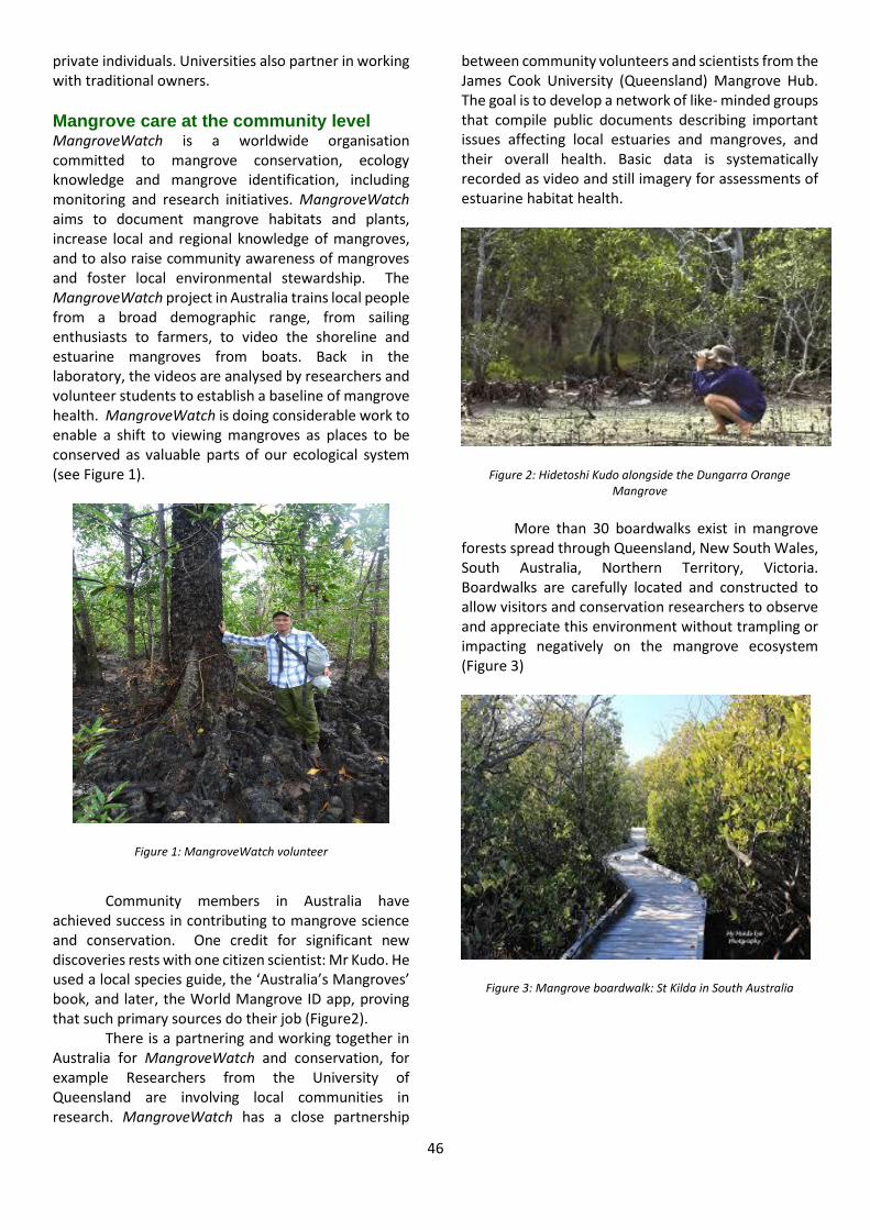
46
private individuals. Universities also partner in working with traditional owners.
Mangrove care at the community level MangroveWatch is a worldwide organisation committed to mangrove conservation, ecology knowledge and mangrove identification, including monitoring and research initiatives. MangroveWatch aims to document mangrove habitats and plants, increase local and regional knowledge of mangroves, and to also raise community awareness of mangroves and foster local environmental stewardship. The MangroveWatch project in Australia trains local people from a broad demographic range, from sailing enthusiasts to farmers, to video the shoreline and estuarine mangroves from boats. Back in the laboratory, the videos are analysed by researchers and volunteer students to establish a baseline of mangrove health. MangroveWatch is doing considerable work to enable a shift to viewing mangroves as places to be conserved as valuable parts of our ecological system (see Figure 1).
Figure 1: MangroveWatch volunteer
Community members in Australia have
achieved success in contributing to mangrove science and conservation. One credit for significant new discoveries rests with one citizen scientist: Mr Kudo. He used a local species guide, the ‘Australia’s Mangroves’ book, and later, the World Mangrove ID app, proving that such primary sources do their job (Figure2).
There is a partnering and working together in Australia for MangroveWatch and conservation, for example Researchers from the University of Queensland are involving local communities in research. MangroveWatch has a close partnership
between community volunteers and scientists from the James Cook University (Queensland) Mangrove Hub. The goal is to develop a network of like- minded groups that compile public documents describing important issues affecting local estuaries and mangroves, and their overall health. Basic data is systematically recorded as video and still imagery for assessments of estuarine habitat health.
Figure 2: Hidetoshi Kudo alongside the Dungarra Orange Mangrove
More than 30 boardwalks exist in mangrove
forests spread through Queensland, New South Wales, South Australia, Northern Territory, Victoria. Boardwalks are carefully located and constructed to allow visitors and conservation researchers to observe and appreciate this environment without trampling or impacting negatively on the mangrove ecosystem (Figure 3)
Figure 3: Mangrove boardwalk: St Kilda in South Australia
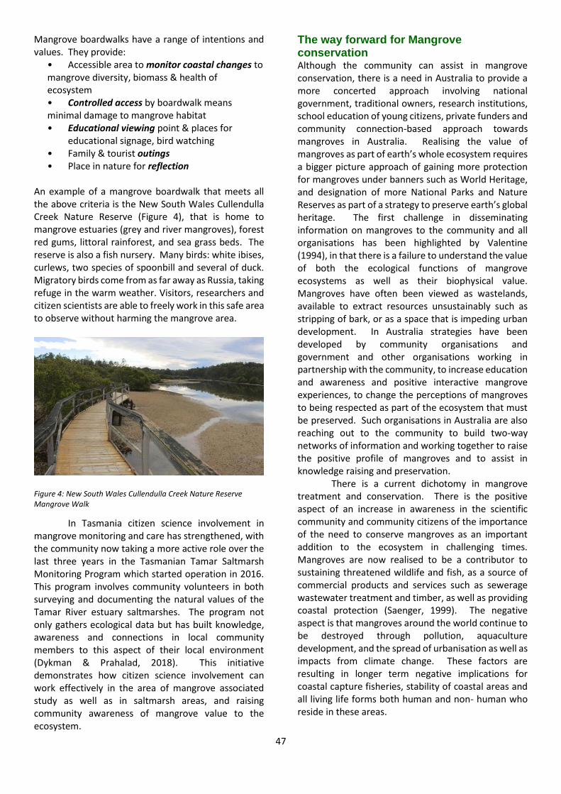
47
Mangrove boardwalks have a range of intentions and values. They provide:
• Accessible area to monitor coastal changes to mangrove diversity, biomass & health of ecosystem • Controlled access by boardwalk means minimal damage to mangrove habitat • Educational viewing point & places for
educational signage, bird watching • Family & tourist outings • Place in nature for reflection
An example of a mangrove boardwalk that meets all the above criteria is the New South Wales Cullendulla Creek Nature Reserve (Figure 4), that is home to mangrove estuaries (grey and river mangroves), forest red gums, littoral rainforest, and sea grass beds. The reserve is also a fish nursery. Many birds: white ibises, curlews, two species of spoonbill and several of duck. Migratory birds come from as far away as Russia, taking refuge in the warm weather. Visitors, researchers and citizen scientists are able to freely work in this safe area to observe without harming the mangrove area.
Figure 4: New South Wales Cullendulla Creek Nature Reserve Mangrove Walk
In Tasmania citizen science involvement in mangrove monitoring and care has strengthened, with the community now taking a more active role over the last three years in the Tasmanian Tamar Saltmarsh Monitoring Program which started operation in 2016. This program involves community volunteers in both surveying and documenting the natural values of the Tamar River estuary saltmarshes. The program not only gathers ecological data but has built knowledge, awareness and connections in local community members to this aspect of their local environment (Dykman & Prahalad, 2018). This initiative demonstrates how citizen science involvement can work effectively in the area of mangrove associated study as well as in saltmarsh areas, and raising community awareness of mangrove value to the ecosystem.
The way forward for Mangrove conservation Although the community can assist in mangrove conservation, there is a need in Australia to provide a more concerted approach involving national government, traditional owners, research institutions, school education of young citizens, private funders and community connection-based approach towards mangroves in Australia. Realising the value of mangroves as part of earth’s whole ecosystem requires a bigger picture approach of gaining more protection for mangroves under banners such as World Heritage, and designation of more National Parks and Nature Reserves as part of a strategy to preserve earth’s global heritage. The first challenge in disseminating information on mangroves to the community and all organisations has been highlighted by Valentine (1994), in that there is a failure to understand the value of both the ecological functions of mangrove ecosystems as well as their biophysical value. Mangroves have often been viewed as wastelands, available to extract resources unsustainably such as stripping of bark, or as a space that is impeding urban development. In Australia strategies have been developed by community organisations and government and other organisations working in partnership with the community, to increase education and awareness and positive interactive mangrove experiences, to change the perceptions of mangroves to being respected as part of the ecosystem that must be preserved. Such organisations in Australia are also reaching out to the community to build two-way networks of information and working together to raise the positive profile of mangroves and to assist in knowledge raising and preservation.
There is a current dichotomy in mangrove treatment and conservation. There is the positive aspect of an increase in awareness in the scientific community and community citizens of the importance of the need to conserve mangroves as an important addition to the ecosystem in challenging times. Mangroves are now realised to be a contributor to sustaining threatened wildlife and fish, as a source of commercial products and services such as sewerage wastewater treatment and timber, as well as providing coastal protection (Saenger, 1999). The negative aspect is that mangroves around the world continue to be destroyed through pollution, aquaculture development, and the spread of urbanisation as well as impacts from climate change. These factors are resulting in longer term negative implications for coastal capture fisheries, stability of coastal areas and all living life forms both human and non- human who reside in these areas.
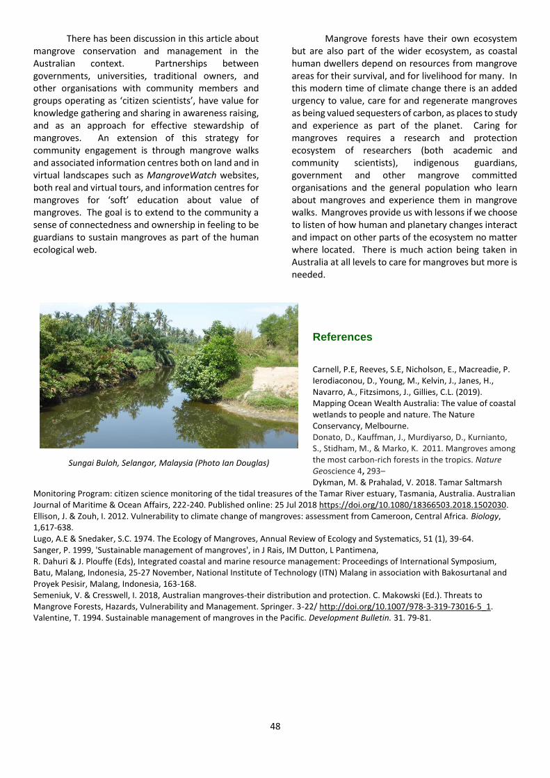
48
There has been discussion in this article about mangrove conservation and management in the Australian context. Partnerships between governments, universities, traditional owners, and other organisations with community members and groups operating as ‘citizen scientists’, have value for knowledge gathering and sharing in awareness raising, and as an approach for effective stewardship of mangroves. An extension of this strategy for community engagement is through mangrove walks and associated information centres both on land and in virtual landscapes such as MangroveWatch websites, both real and virtual tours, and information centres for mangroves for ‘soft’ education about value of mangroves. The goal is to extend to the community a sense of connectedness and ownership in feeling to be guardians to sustain mangroves as part of the human ecological web.
Mangrove forests have their own ecosystem but are also part of the wider ecosystem, as coastal human dwellers depend on resources from mangrove areas for their survival, and for livelihood for many. In this modern time of climate change there is an added urgency to value, care for and regenerate mangroves as being valued sequesters of carbon, as places to study and experience as part of the planet. Caring for mangroves requires a research and protection ecosystem of researchers (both academic and community scientists), indigenous guardians, government and other mangrove committed organisations and the general population who learn about mangroves and experience them in mangrove walks. Mangroves provide us with lessons if we choose to listen of how human and planetary changes interact and impact on other parts of the ecosystem no matter where located. There is much action being taken in Australia at all levels to care for mangroves but more is needed.
References
Carnell, P.E, Reeves, S.E, Nicholson, E., Macreadie, P. Ierodiaconou, D., Young, M., Kelvin, J., Janes, H., Navarro, A., Fitzsimons, J., Gillies, C.L. (2019). Mapping Ocean Wealth Australia: The value of coastal wetlands to people and nature. The Nature Conservancy, Melbourne. Donato, D., Kauffman, J., Murdiyarso, D., Kurnianto, S., Stidham, M., & Marko, K. 2011. Mangroves among the most carbon-rich forests in the tropics. Nature Geoscience 4, 293– Dykman, M. & Prahalad, V. 2018. Tamar Saltmarsh
Monitoring Program: citizen science monitoring of the tidal treasures of the Tamar River estuary, Tasmania, Australia. Australian Journal of Maritime & Ocean Affairs, 222-240. Published online: 25 Jul 2018 https://doi.org/10.1080/18366503.2018.1502030. Ellison, J. & Zouh, I. 2012. Vulnerability to climate change of mangroves: assessment from Cameroon, Central Africa. Biology, 1,617-638. Lugo, A.E & Snedaker, S.C. 1974. The Ecology of Mangroves, Annual Review of Ecology and Systematics, 51 (1), 39-64. Sanger, P. 1999, 'Sustainable management of mangroves', in J Rais, IM Dutton, L Pantimena, R. Dahuri & J. Plouffe (Eds), Integrated coastal and marine resource management: Proceedings of International Symposium, Batu, Malang, Indonesia, 25-27 November, National Institute of Technology (ITN) Malang in association with Bakosurtanal and Proyek Pesisir, Malang, Indonesia, 163-168. Semeniuk, V. & Cresswell, I. 2018, Australian mangroves-their distribution and protection. C. Makowski (Ed.). Threats to Mangrove Forests, Hazards, Vulnerability and Management. Springer. 3-22/ http://doi.org/10.1007/978-3-319-73016-5_1. Valentine, T. 1994. Sustainable management of mangroves in the Pacific. Development Bulletin. 31. 79-81.
Sungai Buloh, Selangor, Malaysia (Photo Ian Douglas)
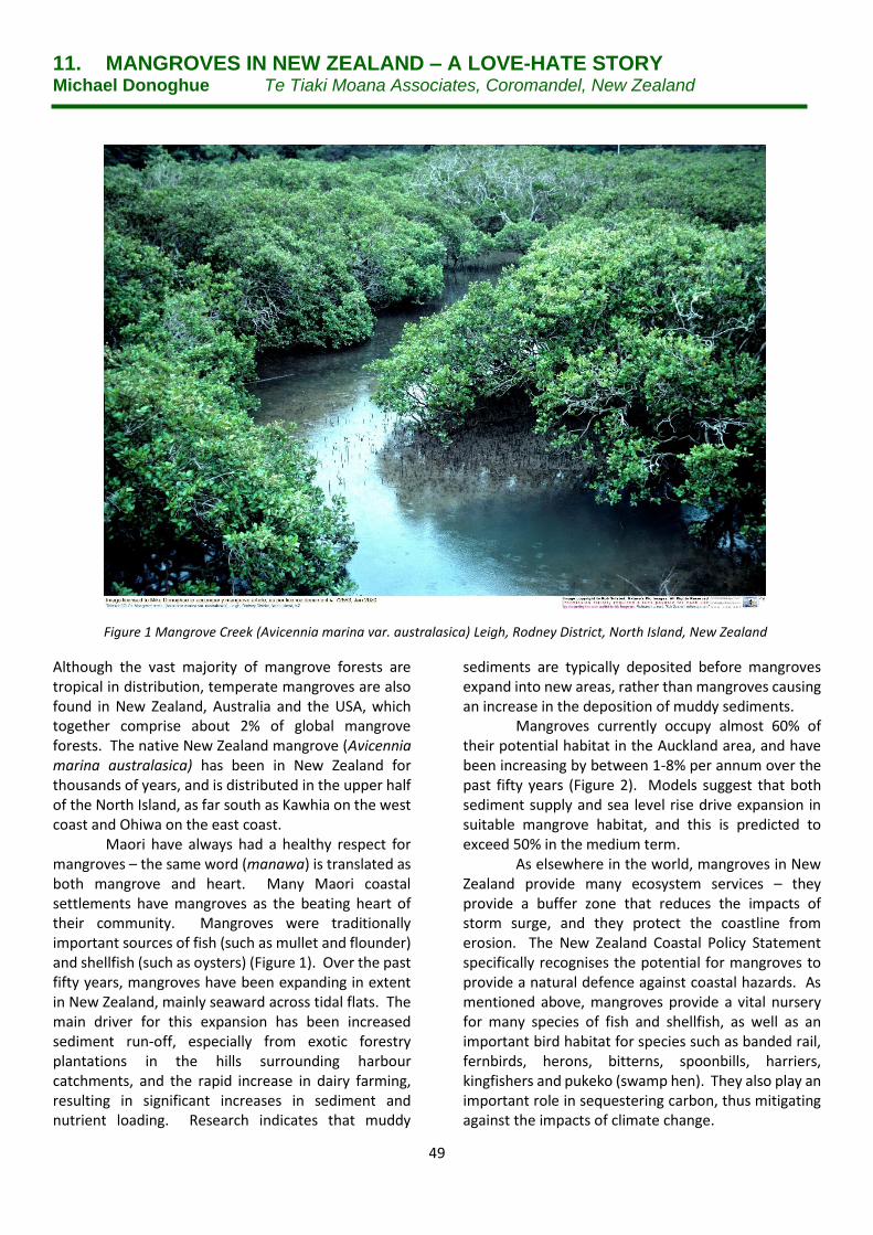
49
11. MANGROVES IN NEW ZEALAND – A LOVE-HATE STORY Michael Donoghue Te Tiaki Moana Associates, Coromandel, New Zealand
Although the vast majority of mangrove forests are tropical in distribution, temperate mangroves are also found in New Zealand, Australia and the USA, which together comprise about 2% of global mangrove forests. The native New Zealand mangrove (Avicennia marina australasica) has been in New Zealand for thousands of years, and is distributed in the upper half of the North Island, as far south as Kawhia on the west coast and Ohiwa on the east coast.
Maori have always had a healthy respect for mangroves – the same word (manawa) is translated as both mangrove and heart. Many Maori coastal settlements have mangroves as the beating heart of their community. Mangroves were traditionally important sources of fish (such as mullet and flounder) and shellfish (such as oysters) (Figure 1). Over the past fifty years, mangroves have been expanding in extent in New Zealand, mainly seaward across tidal flats. The main driver for this expansion has been increased sediment run-off, especially from exotic forestry plantations in the hills surrounding harbour catchments, and the rapid increase in dairy farming, resulting in significant increases in sediment and nutrient loading. Research indicates that muddy
sediments are typically deposited before mangroves expand into new areas, rather than mangroves causing an increase in the deposition of muddy sediments.
Mangroves currently occupy almost 60% of their potential habitat in the Auckland area, and have been increasing by between 1-8% per annum over the past fifty years (Figure 2). Models suggest that both sediment supply and sea level rise drive expansion in suitable mangrove habitat, and this is predicted to exceed 50% in the medium term.
As elsewhere in the world, mangroves in New Zealand provide many ecosystem services – they provide a buffer zone that reduces the impacts of storm surge, and they protect the coastline from erosion. The New Zealand Coastal Policy Statement specifically recognises the potential for mangroves to provide a natural defence against coastal hazards. As mentioned above, mangroves provide a vital nursery for many species of fish and shellfish, as well as an important bird habitat for species such as banded rail, fernbirds, herons, bitterns, spoonbills, harriers, kingfishers and pukeko (swamp hen). They also play an important role in sequestering carbon, thus mitigating against the impacts of climate change.
Figure 1 Mangrove Creek (Avicennia marina var. australasica) Leigh, Rodney District, North Island, New Zealand
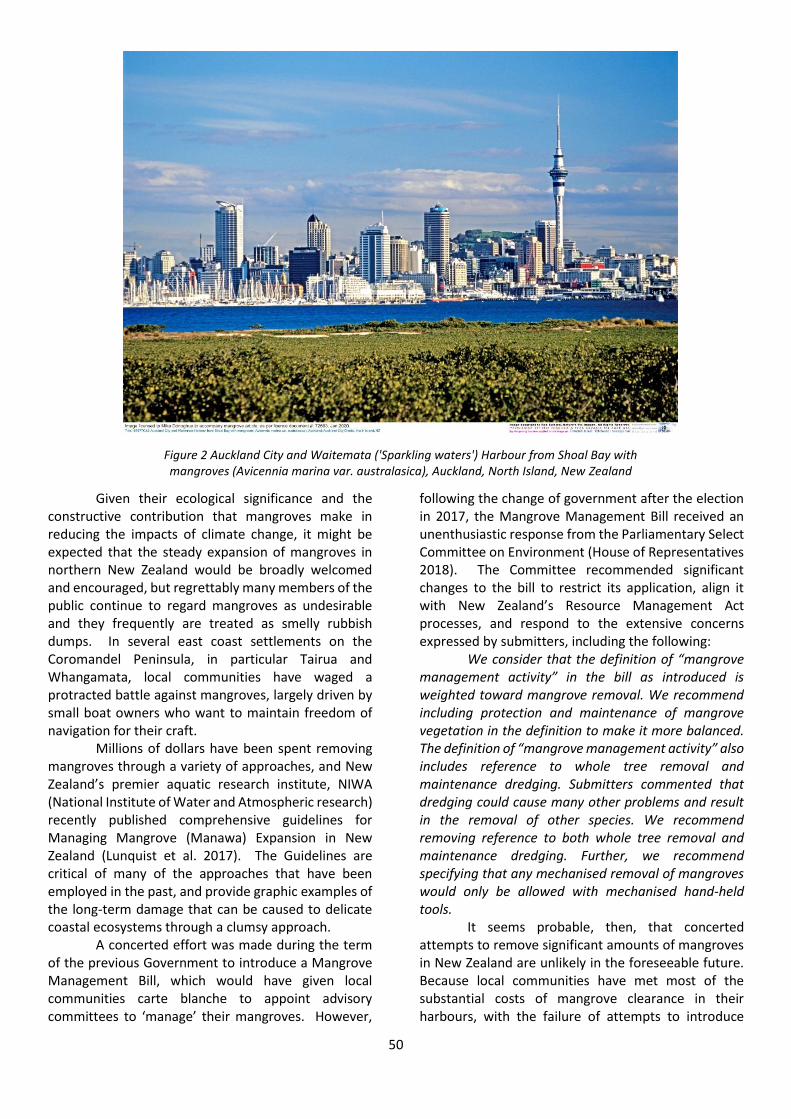
50
Given their ecological significance and the constructive contribution that mangroves make in reducing the impacts of climate change, it might be expected that the steady expansion of mangroves in northern New Zealand would be broadly welcomed and encouraged, but regrettably many members of the public continue to regard mangroves as undesirable and they frequently are treated as smelly rubbish dumps. In several east coast settlements on the Coromandel Peninsula, in particular Tairua and Whangamata, local communities have waged a protracted battle against mangroves, largely driven by small boat owners who want to maintain freedom of navigation for their craft.
Millions of dollars have been spent removing mangroves through a variety of approaches, and New Zealand’s premier aquatic research institute, NIWA (National Institute of Water and Atmospheric research) recently published comprehensive guidelines for Managing Mangrove (Manawa) Expansion in New Zealand (Lunquist et al. 2017). The Guidelines are critical of many of the approaches that have been employed in the past, and provide graphic examples of the long-term damage that can be caused to delicate coastal ecosystems through a clumsy approach.
A concerted effort was made during the term of the previous Government to introduce a Mangrove Management Bill, which would have given local communities carte blanche to appoint advisory committees to ‘manage’ their mangroves. However,
following the change of government after the election in 2017, the Mangrove Management Bill received an unenthusiastic response from the Parliamentary Select Committee on Environment (House of Representatives 2018). The Committee recommended significant changes to the bill to restrict its application, align it with New Zealand’s Resource Management Act processes, and respond to the extensive concerns expressed by submitters, including the following:
We consider that the definition of “mangrove management activity” in the bill as introduced is weighted toward mangrove removal. We recommend including protection and maintenance of mangrove vegetation in the definition to make it more balanced. The definition of “mangrove management activity” also includes reference to whole tree removal and maintenance dredging. Submitters commented that dredging could cause many other problems and result in the removal of other species. We recommend removing reference to both whole tree removal and maintenance dredging. Further, we recommend specifying that any mechanised removal of mangroves would only be allowed with mechanised hand-held tools.
It seems probable, then, that concerted attempts to remove significant amounts of mangroves in New Zealand are unlikely in the foreseeable future. Because local communities have met most of the substantial costs of mangrove clearance in their harbours, with the failure of attempts to introduce
Figure 2 Auckland City and Waitemata ('Sparkling waters') Harbour from Shoal Bay with mangroves (Avicennia marina var. australasica), Auckland, North Island, New Zealand
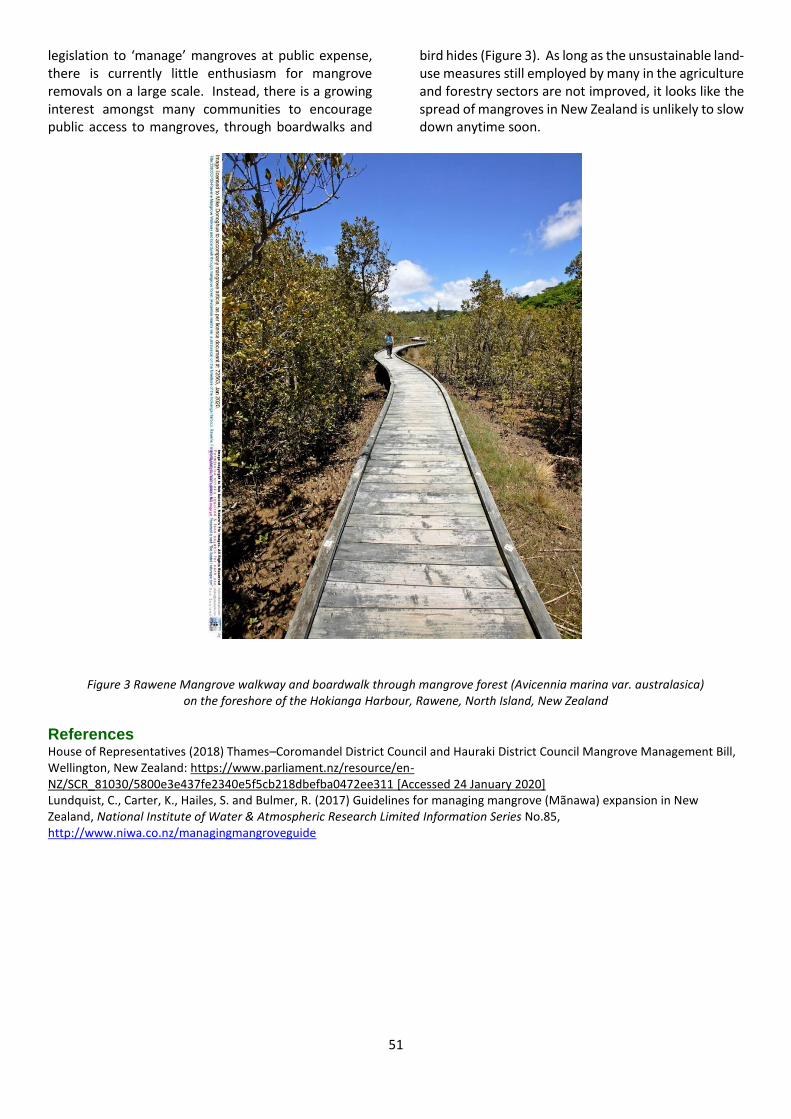
51
legislation to ‘manage’ mangroves at public expense, there is currently little enthusiasm for mangrove removals on a large scale. Instead, there is a growing interest amongst many communities to encourage public access to mangroves, through boardwalks and
bird hides (Figure 3). As long as the unsustainable land-use measures still employed by many in the agriculture and forestry sectors are not improved, it looks like the spread of mangroves in New Zealand is unlikely to slow down anytime soon.
Figure 3 Rawene Mangrove walkway and boardwalk through mangrove forest (Avicennia marina var. australasica)
on the foreshore of the Hokianga Harbour, Rawene, North Island, New Zealand
References House of Representatives (2018) Thames–Coromandel District Council and Hauraki District Council Mangrove Management Bill, Wellington, New Zealand: https://www.parliament.nz/resource/en-NZ/SCR_81030/5800e3e437fe2340e5f5cb218dbefba0472ee311 [Accessed 24 January 2020] Lundquist, C., Carter, K., Hailes, S. and Bulmer, R. (2017) Guidelines for managing mangrove (Mãnawa) expansion in New Zealand, National Institute of Water & Atmospheric Research Limited Information Series No.85, http://www.niwa.co.nz/managingmangroveguide
52
WEBSITES
https://bluecharter.thecommonwealth.org/action-groups/mangrove-restoration/ The Commonwealth Blue Charter is an agreement by all 54 Commonwealth countries to actively co-operate to: solve ocean-related problems and to meet commitments for sustainable ocean development. Mangroves have a special action group, led by Sri Lanka. ****
https://www.tropwater.com/project/mangrove-research-hub/
The Mangrove Hub conducts world leading research into mangrove and tidal wetland ecosystem, led by Dr Norm
Duke, mangrove ecologists since 1978, and Jock Mackenzie, tidal wetland scientist and MangroveWatch coordinator.
****
https://cat.org.in/portfolio/mangrove-conservation/ Karangsong, a mangrove forest in Indramayu, West Java, has been named a research and learning centre for the western part of Indonesia.
Conservation Action Trust spearheaded in proposing a Mangrove Wetland Centre in Mumbai. A landmark partnership between the Conservation Action Trust (CAT) and HSBC has enabled CAT to complete first phase of this
project. When a proven ecosystem restoration method also helps reduce poverty and build economic resilience, governments will often back them as a win-win solution. *****
https://www.unenvironment.org/news-and-stories/story/mangrove-conservation-more-valuable-ever-thanks-carbon-trading
The UN Environment Program, the Kenya Forest Service, the Kenya Marine and Fisheries Research Institute and partners recently launched the Vanga Blue Forests Project on the Kenyan coast, a groundbreaking initiative to trade carbon credits from mangrove conservation and restoration. ****
https://www.worldwildlife.org/ecoregions/nt1403
The Bahamian mangroves are found in a large area of shallow water that is of high importance for its ecological productivity. The mangroves are an important source of nutrients and provide shelter for many juvenile species of fish associated with this area, which also includes extensive coral reefs and seagrass beds (Buchan 2000). They also contain areas of high importance for large populations of resident and migratory waterfowl (Frazier 1999) as well as many other species of avifauna. ****
https://assets.publishing.service.gov.uk/government/uploads/system/uploads/attachment_data/file/607715/7._Mangroves_combined.pdf
Commonwealth Marine Economics Programmes. Impacts of Climate Change on Mangrove Ecosystems in the Coastal and Marine Environments of Caribbean Small Island Developing States (SIDS). ****
www.gepadg.com
Gunjur Environmental Protection and Development Group (GEPADG) work on protecting mangroves in the Gambia

53
Support CHEC
CHEC is a membership organisation and relies on support
from individuals and organisations to do the work we set up
in our mission to do
A membership form can be found at:
http://www.chechinternational.org/membership/
All membership and donations are warmly appreciated
Follow us on Twitter:
Twitter: @CwHumanEcology
Facebook: /InternationalCHEC/
54
COMMONWEALTH HUMAN ECOLOGY COUNCIL
CHEC
4, Hurlingham Studios Ranelagh Gardens London SW6 3PA
Email: [email protected]
www.checinternational.org