Embed Size (px)
Citation preview

Faculty of Geodesy, University of Zagreb
Chair of Spatial Information Management
Transparent Valuation as a Planning
Support for Just Land Management
System (LMS)
Hrvoje TOMIĆ, Siniša MASTELIĆ IVIĆ, Miodrag ROIĆ, Croatia
Contents
• Introduction
• Land management
• Real estate valuation
• The impact of Land Administration on land value
• Overview of Croatian Land Administration System
• Valuation in Land consolidation - rural areas/Land readjustment- urban areas
• ConclusionFaculty of Geodesy, University of Zagreb
Chair of Spatial Information Management

Introduction
• Effective spatial resources management is one of the main features of healthy economic growth of a region
• Land/immovables - more or less attractive depending on difference in position, construction, fertility and/or natural resources
• Valuation is process of assigning values to land locations/ properties
Faculty of Geodesy, University of Zagreb
Chair of Spatial Information Management
Real estate valuation
• methods of valuation
(choice of methods
depends on property):
– Sales comparison
– Income capitalization
– Cost approach method
• Individual - single
property
valuation
• Mass property
valuation
Faculty of Geodesy, University of Zagreb
Chair of Spatial Information Management

Mass valuation methods - AVMs
• Mass Valuation – Automated
Valuation Methods (AVM):
– GIS
– Artificial Neural Networks (ANN)
– Multiple Regression Analysis(MRA)
– Combinations
Faculty of Geodesy, University of Zagreb
Chair of Spatial Information Management
Mass real estate valuation
factorsrural areas:
•Land parcels
•Topographic data
– (dtm, forest areas, water
areas, ...)
•Land quality, rain
expectancy, average
temperature,
•Legal constraints:
– Intended land use, district
borders ...
urban areas:
• Land parcels
• Legal
constraints:– Intended land
use, district
borders ...
Faculty of Geodesy, University of Zagreb
Chair of Spatial Information Management

Croatian LAS
• two basic registers:
– Cadastre - Classic European system of land cadastral parcels, 3327 cadastral municipalities, currently in process of transition from "Land Cadastre" to "Real Estate Cadastre“, SGA
– Land Book - responsibility of Local Courts, registration of property units and associated RRR (Rights, Responsibilities and Restrictions).
Faculty of Geodesy, University of Zagreb
Chair of Spatial Information Management
Methods of Cadastral Surveys in
Croatia
Graphical method – geodetic planetable
1800. 1900. 2000.
Polar numerical method
Land consolidation
GNSS
Photogrammetric methods
Orthogonal numerical method

Faculty of Geodesy, University of Zagreb
Chair of Spatial Information Management
Current state – web services
Joint Information System (JIS):establish a common database of the
cadastre and land registries and a
single application for keeping and
maintaining the data
2003. - end of 2009.
alphanumerical and graphical data
geoportal.dgu.hr – cadastral data,
WMS – digital orthophoto data and
topographic data
• www.katastar.hr Cadastral data browser,
graphic + alphanumerical
data
• www.pravosudje.hrLand Book registry browser,
alphanumerical data
Faculty of Geodesy, University of Zagreb
Chair of Spatial Information Management
Croatian current state: mass
valuation• mass valuation for taxation
purposes since Franciscan Cadastre -
beginning of 19th Century:• cadastral classification -
"katastarsko klasiranje":
determination of parcels
agriculural production income
• detailed procedure but irregular
maintenance of data
• abolished in 2001

Land Administration/Sustainable
Development (in theory)
• sustainable development needs to be
based on two opposed concept of care
of space:– static (Cadastre and Land Register -
guarantee existing rights)
– dynamic (spatial planning, conditioned by
urban/rural development program)
Croatian LAS problems (...as is)
• Around 70% of the official cadastral maps
(in use today) were made by graphic survey
(problem in transition from Land Cadastre
to Real Estate Cadastre) - inhomogeneous
cadastral data
• Mismatch beetwen data registered in
Land Book, Cadastre and on the field
Land consolidation/Land
readjustment - current stateRural land consolidation:• till 1959, ~650 000 ha were
consolidated (~20% of arable land )
• unenforceable legislation (Law on Land consolidation dates from 1979), new Law on Consolidation in preparation for over 15 years...
Urban land readjustment:• implemented in 2007 with the Law on Spatial Planning and Building:
"Procedure of merging building land parcels in one whole and its division on building and other parcels in accordance with the detailed urban plan"
• ambiguous and incomplete: considers only square meters - after this legislation no readjustment was conducted
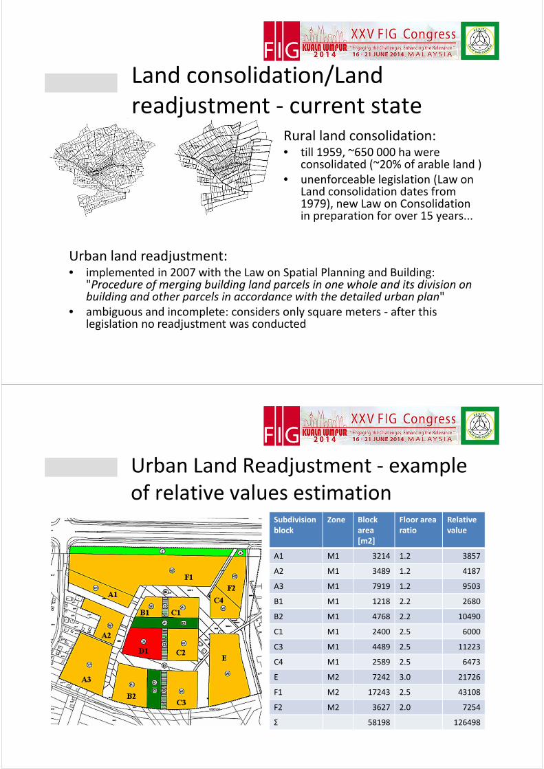
Urban Land Readjustment - example
of relative values estimationSubdivision
block
Zone Block
area
[m2]
Floor area
ratio
Relative
value
A1 M1 3214 1.2 3857
A2 M1 3489 1.2 4187
A3 M1 7919 1.2 9503
B1 M1 1218 2.2 2680
B2 M1 4768 2.2 10490
C1 M1 2400 2.5 6000
C3 M1 4489 2.5 11223
C4 M1 2589 2.5 6473
E M2 7242 3.0 21726
F1 M2 17243 2.5 43108
F2 M2 3627 2.0 7254
Σ 58198 126498

More detailed mass valuation
procedures/analyses
Visibility polygon for each property unit, valuation accordingly to corespondent area of view - Oracle 11g, PL/SQL procedure
Instead of conclusion
Faculty of Geodesy, University of Zagreb
Chair of Spatial Information Management
• mass valuation system - great significance in the Urban Land Readjustment procedure (estimating the relative values of parcels before readjustment and new building parcels after
completed urban readjustment) and Rural Land Consolidation procedure (same as urban, except different valuation factors)
• transparent and clear valuation procedures as guarantee of the system fairness.

Thank you for your attention!
Transparent Valuation as a Planning Support
for Just Land Management System (LMS)
Hrvoje TOMIĆ, Siniša MASTELIĆ IVIĆ, Miodrag ROIĆ
2014 FIFA World Cup: Croatia vs Cameroon19th June 2014, 06:00 AM