Embed Size (px)
Citation preview

How High are you?... Really Temperature Compensation becomes
mandatory in the US starting
September 17th, 2015
TUG September 16th, 2015
Woody Saland, PhD Falcon Jet Director Avionics Programs

When going from a High to a Low look out Below !
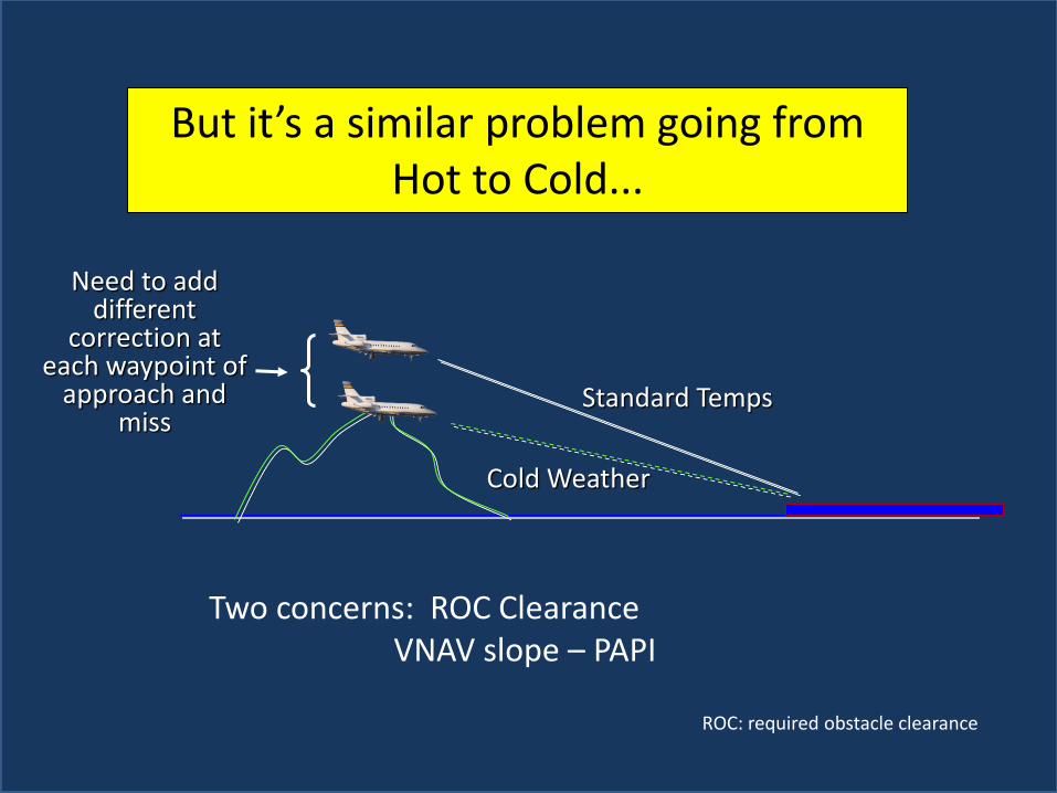
But it’s a similar problem going from Hot to Cold...
Standard Temps
Cold Weather
Need to add different
correction at each waypoint of
approach and miss
Two concerns: ROC Clearance VNAV slope – PAPI
ROC: required obstacle clearance

Charted Procedures are based on True altitudes relative to Mean Sea Level as given for the airport (ie, MSL)
All of these altitudes are based
on MSL of the airport and are
thus True Altitudes
"Mean sea level was held fixed at the sites of 26 tide gauges, 21 in the U.S.A. and 5 in Canada. The datum is defined by the observed heights of mean sea level at the 26 tide gauges and by the set of elevations of all bench marks resulting from the adjustment. A total of 106,724 km of leveling was involved, constituting 246 closed circuits and 25 circuits at sea level."

Your Altitude relative to what ?
FL MSL Radio Altimeter

On board we can “see” three different altitudes Radar Altitude ( absolute), Indicated Baro Altitude and GPS
altitude
You’re adjusting the baro setting so that your Indicated Altitude will read the
airport MSL when you land

Be Careful when using GPS Altitude
Notice there’s no Knob to set for local altimeter setting

GPS Altitude is the height above the Ellipsoid that WGS-84 agreed best describes the EARTH
WGS-84 MODEL
Why does the GPS altitude differ from Baro ?

Up until 1928, before instrument flying, altimeters
were non adjustable barometers
Charles Lindbergh’s flight to Paris: May 20–21, 1927 QFE: knob adjusted zero field elevation of departing airport

September 24th, 1929 Jimmy Doolittle Proves you can fly “blind”
Using the Kollsman Altimeter, and a Sperry Gyroscope Company developed “artificial horizon.“
NY-2 airplane- Mitchell Field, NY

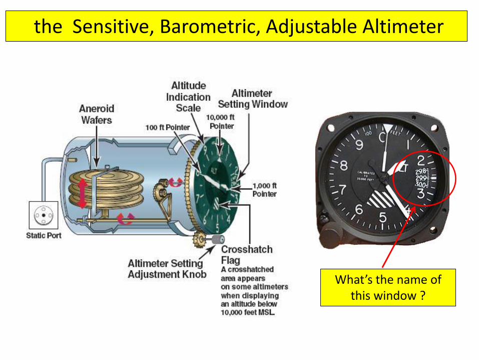
the Sensitive, Barometric, Adjustable Altimeter
What’s the name of this window ?

Kollsman window
The Settings window is named after it’s inventor, Paul Kollsman

Kollsman studied civil engineering in Stuttgart and Munich (Technical University Munich). In 1923 he emigrated from Germany to the USA. He worked as truck-driver until he found a position at Pioneer Instruments Co. in Brooklyn, New York. In 1928 he founded his own company, Kollsman Instruments Co., with $500 of seed money. He was searching for the right opportunity to launch his product a long time until Jimmy Doolittle flight tested his instruments. The altimeter setting window of the sensitive aircraft altimeter is named the "Kollsman window" after him. In 1939, Kollsman, who was then residing in Greenwich, Connecticut, sold his company for more than $4,000,000. In 1940 he purchased 800 acres (3.2 km2) of land outside of Manchester Vermont from International Paper Company, and founded Snow Valley, which formally opened in January 1942, and was one of the earliest ski areas in the United States
In 1945 Kollsman purchased The Enchanted Hill, a fabulous estate in Beverly Hills, California, which contained a Mediterranean Revival main house of 10,000 square feet (with 12 acres (49,000 m2) of formal gardens) which Mr. Kollsman eventually augmented to 120 acres (0.49 km2)
Microsoft co-founder Paul Allen acquired the estate from Kollsman's widow in 1997 for $20 million and razed the landmark house in 2000, with plans to build two 50,000-square-foot (4,600 m2) mansions in its place.
Paul Kollsman
Born: 2-22-1900 Died: 9-26-1982

But there’s only one knob, can’t adjust for non-ISA temperature above the field !
With the one knob, I can at least assure when I land, I should see an airport altitude that is the charted MSL of the field – regardless of temperature !
So the closer to the field the more accurate the altimeter is
But off the ground, our altimeter assumes a ISA adiabatic lapse rate for the temperature…. what if its colder (or hotter) than standard ?...... We’ll be lower or
higher than True….

Indicated vs. True Altitude
So even though I’ve adjusted my altimeter
so that when I land I’m at the field elevation, aloft
it’s still “not true” if the temperature is
not ISA

ROC
PATH
MVA
At least three operational considerations
So What’s the problem if the air is non-standard ?

Historically, approaches didn’t have temperature restrictions
Either you were on a precision Glide Slope where temperature doesn’t matter, or the MDA was high enough
that even in cold weather, there was no concern

What does the Inverse triangle “T” stand for ?

But, a FAA Notam created Restricted Airports over terrain clearance concerns and it’s mandatory !
Now its about ROC
December 11, 2014

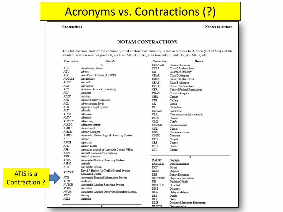
Acronyms vs. Contractions (?)
ATIS is a Contraction ?

ACRONYM: a word formed from the initial letters or groups of letters of words in a set phrase or series of words and pronounced as a separate word, as Wac from Women's Army Corps, OPEC from Organization of Petroleum Exporting Countries, or loran from long-range navigation.
CONTRACTION: a shortened form of a word or group of words, with the omitted letters often replaced in written English by an apostrophe, as e'er for ever, isn't for is not, dep't for department.

Sept. 17th, 2015
Latest update on the Cold Temp. Airports Notam


If you type in the address in the INFO you get:


Compliance is Mandatory !

The FAA has introduced the concept of temp. comp per segment
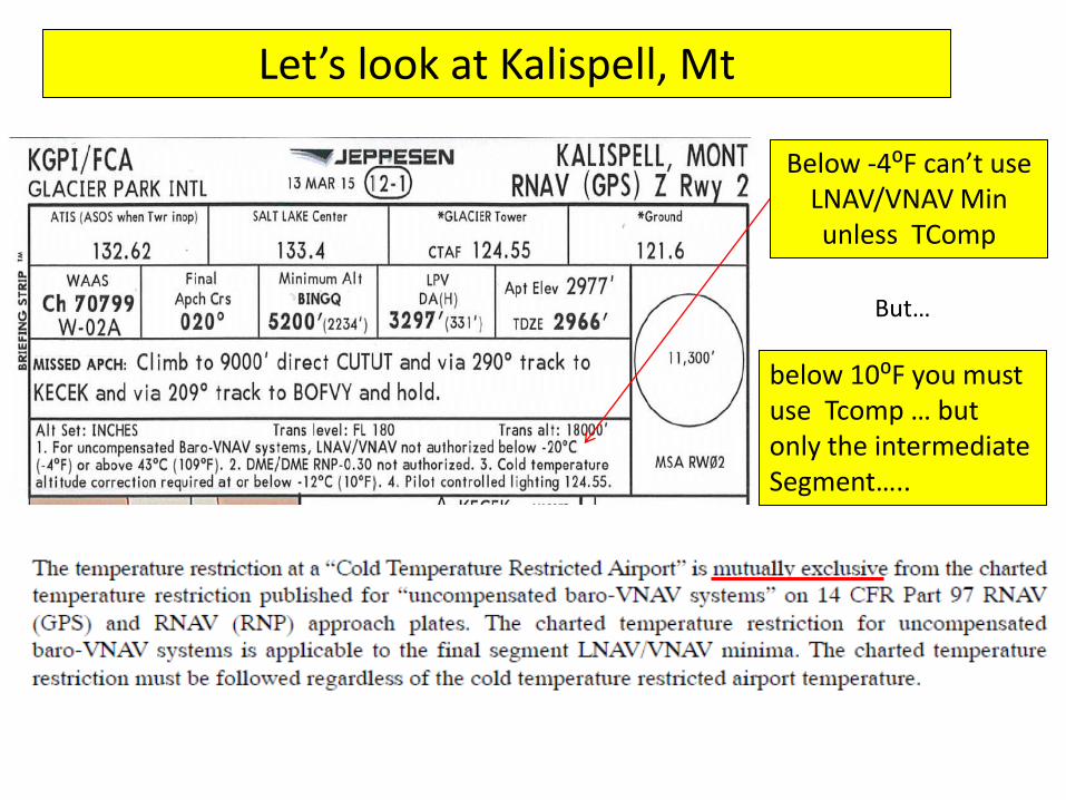
Let’s look at Kalispell, Mt
Below -4⁰F can’t use LNAV/VNAV Min unless TComp
But…
below 10⁰F you must use Tcomp … but only the intermediate Segment…..

Although no “X” , it’s implied that the final segment also must be compensated.
New Snowflake Symbol….
So if I saw a snowflake and the temperature was below stated, without a full T Comp system, only listed segments need to be adjusted

Except that Jepp doesn’t use a snowflake !
Look at how temp. comp. is required for an ILS at a temp.
restricted airport

Pilots are to tell ATC when they are using “cold temperature ops”

The ICAO Cold Temp. Error Table
Doesn’t mention the table is only accurate for sea level airports….

Table comes from ICAO Document
4.3.1 Approx. correction…. Increase waypoint height by 4% for every 10⁰C below standard temp.
4.3.2 Tables are for sea level airports. Therefore they are conservative for higher airports….

FAA
Dassault Codde 2 has added the full ICAO table
Note the additive goes to zero at the
field

Look how Australia’s chart has you enter using first the airport elevation first, then height and temp…. More
accurate than the “famous” table
To be more accurate you need to consider the field elevation

EASy II Temp. Comp. - computes all approach and missed waypoints
For all the approach and missed waypoints….. EASy II is the most accurate and complete way to compensate

But the numbers will be lower than the table (which is “conservative” )

Minimum Sector Altitudes
US………………………………. No policy Canada ………………………… MSAs adjusted for temp. France …………………………. ATC adjusts by table due to temp. within a band Switzerland …………………. Don’t adjust MSA… adjust QNH Czech Republic …………………between Nov-March… 200’added to MSA Norway………………………. All MSAs use a design of ISA -15⁰C rather than ISA
According to ICAO PANS OPS, minimum vectoring altitudes shall be corrected for temperature. The temperature correction shall be based on seasonal or annual minimum temperature records. In turn, ATC authorities are required, as per ICAO PANS ATM, 8.6.5.2, Note 2, “to provide the controller with minimum altitudes corrected for temperature effect”.
MVA
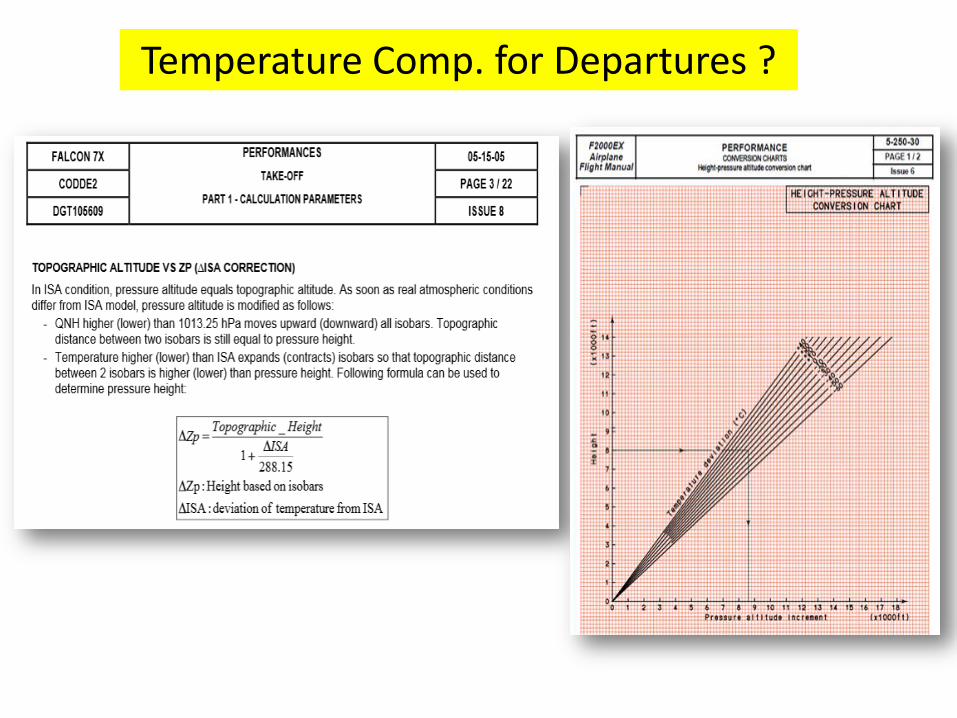
Temperature Comp. for Departures ?

Conclusions: • Starting tomorrow, some 200+ airports will be classified as Cold
Temperature Restricted Airports (check list before you go, or look on the chart)
• Bring a copy of the FAA sea level airports Temp. Comp. Chart along with you if you are going to one of these airports
• The additives are mandatory only for the Segments listed in the Notam (bring along the Notam with you ? ) but apply to ALL approaches... Even an ILS
• Don’t change the Altimeter Setting from what is on the ATIS.... These additives are “added” to the shown numbers on the charts
• Buy a new, EASy II Falcon where Temperature Comp is a simple button push....
or, bring a calculator and some paper to look up the additives.... • Stay warm (and safe) out there .....