Embed Size (px)
Citation preview

How Color andLight ChangeOur Perception
Deirdre A. TerzianB. A. Studio Art, Smith CollegeNorthampton, MassachusettsJune 1986
of Space,andin
TimeMovement
submittedto the
Department of Architecturein partial fulfillment of therequirements for the degree ofMaster of Architectureat theMassachusetts Institute ofTechnologyFebruary 1997
Signature of the(author
Acceptec6fy - \-\U "
Deirdre A. TerzianDepartment of ArchitectureJanuary 17, 1997
Andrew ScottChairpersonCommittee on Graduate StudentsAssociate Professor of Architecture
Certified by
-k ~. 0 _ IC~rtified by (9
lmre HalaszThesis SupervisorProfessor of Architecture, Emeritus
Julie DorseyThesis SupervisorAssistant Professor of Architecture
© 1997 Deirdre A. Terzian. All rights reserved. The author hereby grants to MIT permission to repro-duce and to distribute publicly paper and electronic copies of this document in whole or part.
MAR 261997 1
Arch itecture

Thesis Committee
Imre HalaszThesis SupervisorProfessor of Architecture, Emeritus
Julie DorseyThesis SupervisorAssistant Professor of Architecture
Dimitris AntonakakisThesis CriticVisiting Professor
How Color and Light ChangeOur Perception of Space, Timeand Movement in Architecture
Abstractby Deirdre A. Terzian
This thesis explores the way in which color and light changethe way we understand our built environment.
The site for this thesis is at the west end of the Esplanade.The Esplanade is a recreational park along the Boston sideof the Charles River in Massachusetts. The park has builtfacilities for sailing, concerts, and eating that detour off to
one side or the other of the park's system of paths. Thetopography of the site is quite flat. Movement through thepark is seemingly timeless as one walks parallel to the water,past unremarkable landmarks.
The west end of the Esplanade is a long, narrow strip of landbetween the Charles River and a small lagoon. Through theexploration of color and light, this thesis tries to recover asense of time at both a large and small scale as one movesthrough the site. The sense of time is revealed through theconstantly changing interaction between light and materi-als as the sun moves from east to west. It also tries to intro-duce a new spacial understanding of the site by breakingaway from the existing parallel movement both physicallyand visually.
The vehicle for this exploration is a proposal for a recre-ational building that includes a swimming pool with chang-ing facilities, cafe and community art gallery.
Thesis Supervisor: Imre Halasz, Professor of Architecture, Emeritus
Thesis Supervisor: Julie Dorsey, Assistant Professor of Architecture
Submitted to the Department of Architecture on January 17, 1997 in partial fulfillment of the requirements for the degree of Master of Architecture.

4

Acknowledgments
To my mother and father.To Terry.To Alexi.Thank you for all your help and support throughout the pro-gram.
To Imre, Julie and Dimitris.Thank you for your insightful critiques and encouragement.

6
Table of ContentsA b stra c t................................................................................ . . 3
Aknow ledgem ents................................................................. 5
Introduction...........................................................................8
S ite ....................................................................................... . . 1 2
Site Analysis........................................................................... 20
C onceptual Idea .......................... ............................ 22
The Rhythm of M ovem ent.................................................. 24
Betw een the Paths.............................................................. 28
Visual Bridges ....................................................................... 32
Conclusion.......................................................................... 40
Footnotes & Illustration Notes............................................. 43
Bibliography .................................................................... 45

IntroductionLight
As natural light passes through a space highlighting differ-ent materials, our understanding of that space is trans-formed. The light changes the way we perceive the qualityof a material. For example, when light hits a sheet of glass itappears to be opaque but when the light comes frombehind its transparency is revealed. The affects of light onone material also change the perception of the othermaterials around it. The other materials will receive more orless light depending on the reflectiveness of the first mate-rial. As a result of the fact that the sun is always moving andthat the interaction between light and material is constantlychanging, a lifeless surrounding can become animated. Inboth nature and in built environments, these preciousmoments are more often accidental events: they are sel-dom the result of an intentional design scheme.
An interest in photography inspired the investigation of this
thesis. Through photography, it is possible to record theseinstances of light hitting a material. Though the event is fro-zen in a photograph, the process becomes an exercise inobserving the phenomenon. This thesis translates the inter-est in light observed through photography into an architec-tural project.
Light is always a part of the discussion of architecture. Yet,architects that consider light as equally important as allother decisions in the design process stand out as prece-dents to this thesis.
For example, at the Chapel on Mount Rokko in Japan,Tadao Ando cuts narrow slits into the walls and the roof ofthe structure to allow the light to bathe the surfaces of con-crete. The light changes the apparent materiality of theconcrete and transforms the church from a simple concretebox with one large window into an experience of medita-tion and a measuring device for time.

fig. 1. Natural light falling on a wall of wood fig. 2. Chapel at Mount Rokko by Tadao Ando.

Color
The proposition of incorporating color into the investigationof this thesis has its roots in the same observations of light.The moment light hits a wall of color and that color reflectsonto another surface, here again, the quality of that spaceis transformed. Though the choice of materials and appliedcolor are mindfully chosen by an architect, as argued ear-lier, the results are probably more often accidental and notthe original intention of the architect.
Yet, there are examples of architectural work that incorpo-rate the use of color in ways that move beyond a formallydecorative intention. Such examples can be found in workby Dimitris and Suzana Antonakakis in Greece, and Luis Bar-ragan in Mexico,
At the Hotel Lyttos in Crete, Dimitris and Suzana Antonakakisuse applied color on the exterior of a large hotel complex.
By introducing color into the project, the mass of the struc-ture appears to break down and transform the hotel into aseries of small connected structures: the project no longerpresents itself as a vast compound but as something at thescale of a small village. The use of color also helps orient anew visitor to the hotel.
Another architect that ties his instinct for the qualities ofcolor and light into the whole of his architecture is Luis Bar-ragan. At the Gilardi House, in Mexico, an interior poolbecomes an exaggerated three dimensional spacial expe-rience by a selective use of color and an understanding oflight. By painting the column red and the back walls blue,the back wall recedes while the column pops out. The dis-tance between the walls and the column seems greaterthan it actually is. As light hits the water, the rectangularcolumn and the blue walls behind it not only soar throughthe opening in the ceiling but also plummet through thefloor of the pool.

fig. 3. Hotel Lyttos by Suzana and Dimitris Antonakakis. fig. 4. Gilardi House by Luis Barragan.

SiteThe site for the investigation of this thesis is on the Esplanadein Boston, Massachusetts. The Esplanade is a recreationalpark that runs along the Boston side of the Charles River,between the Harvard and Longfellow Bridges. It is a man-made park that did not come into existence until the turn ofthe century.
Up until the end of the 19th century the Charles River wasstill tidal. When the tide went out it revealed an ugly muddyriver floor. It carried with it dangerous currents, bad odorsand pollution as the result of a growth in population and anincrease in industry. It was soon apparent that changeswould have to be made in order to improve the situation. In1881, Charles Davenport proposed a river front develop-ment that included the construction of an esplanade.1
It was also argued at this time, that damming the CharlesRiver would add to the health and the recreational use ofthe river. After much debate, the decision to dam the
Charles River was reached in 1903. It was effectivelydammed by 1908.2
The first version of the Esplanade was built at the same timethe first dam was constructed. The design of the Esplanadewas fairly straightforward. In front of the back lots of the rowhouses that face Beacon Street, ran Embankment Road(which later became Storrow Memorial Drive). In front ofEmbankment Road a wide strip of green was built betweenthe Harvard and Longfellow Bridges. In front of the green apath ran along the edge of the water. 3
The design of the Esplanade as it exists today was devel-oped by Arthur A. Shurcliff. It was built between the early1930's and the early 1950's. Shurcliff's design style was verylikely influenced by Frederick Law Olmsted. Shurcliff'scareer included working for the office of Olmsted, Olmstedand Eliot; 4 the same firm that designed the system of parksin Boston called the Emerald Necklace.

fig. 5. View of the site before the Esplanade is constructed, when theCharles River is still tidal. The view is facing east.
fig. 6. View of the first version of the Esplanade, facing west toward theHarvard bridge.

figs. 7-12 Various views of the Esplanade as it is today.
14


Today the Esplanade is actively used throughout the yearby residents of Boston and Cambridge as well as visitors tothe city. It offers relief from city life and an opportunity toenjoy activities on the Charles River. It is used by strollers,joggers, bicyclists, and sunbathers. It has built facilities forsailing, concerts and eating that detour off one side or theother of the park's systems of paths.
The topography of the Esplanade is uniformly flat. Move-ment through the park is seemingly timeless as one movesparallel to the water past unremarkable landmarks.
This thesis looks at a section of the west end of the Espla-nade. It is the end of a long narrow strip of land, essentiallyan island, that encloses one of the park's lagoons. The limitsof the site for this study are between the last two pedestrianbridges that connect the island back to the embankmentbefore the park continues west and meets the base of theHarvard Bridge.
Mature trees are grouped at the ends of the site near thepedestrian bridges. Between these ends, the land is tree-less. An asphalt path about twelve feet wide runs down themiddle of the this stretch of land. The flatness of the land,the treeless landscape and the centralization of the pathcontribute very little to the pleasure or use of the site. Yet,the desolate nature of this strip of land intensifies the under-standing that one is standing on a piece of land betweentwo very different bodies of water: the Charles River to thenorth, active with boaters and alive with a directional cur-rent, and the Storrow Lagoon to the south, a calm body ofwater, without any recreational activity, that falls short of areflecting pool.
The site is primarily used by sunbathers on either side of thepath. The path is a pedestrian thoroughfare. The onlyclearly defined territories are the treed ends of the land-scape. They are more private and offer an a place to getrelief from the sun.

fig. 13. Aerial view of the Esplanade with the site for the thesis highlighted.
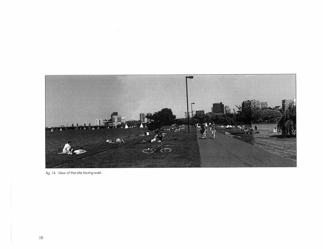
fig. 14. View of the site facing east.

fig. 15. View of site facing west.

Site Analysis
The Esplanade Park is a man-made, formal design. It isunlike the nearby Boston Common Gardens designed byShurcliff's mentor, Frederick Law Olmsted, which wasdesigned to look like natural pastureland or the Fens, whichwere designed to look like natural marshland. The Espla-nade is most definitely read as purposefully designed byman and not by nature.
Looking at the overall site plan of the park, there appears tobe a pattern of a long dimension of about 1,000 feet. In thefirst two bays running west to east, the dimension is markedat the points that the linear island connects to the embank-ment by way of pedestrian bridges. The third bay takes thecurve of the site leading to the fourth bay which is definedby the land jetties. It was through this analysis that the terri-tory for the site of this thesis was decided.
Applying this dimension to the west end of the islandbetween the Storrow Lagoon and the Charles River it is pos-
sible to create a rectangle. The short sides of the rectangleare above the existing pedestrian bridges and the longsides are defined by the edges of the land.
By subdividing the larger rectangle from the left at the pointat which the two diagonals drawn from the corners of therectangle intersect, a smaller rectangle is created andrepeated at the other end. The width of this rectangle isabout the same width as the pedestrian bridges.
Running this new dimension along the diameters of the cir-cumference that define the ends of the lagoon andextending them to the River, a pattern begins to revealitself. This second set of parallel lines also extends backthrough the streets that enclose the west and east ends ofthe row house block on the other side of Storrow Drive. Byrepeating this pattern, a comb-like movement is suggested.It connects the two bodies of water, offering an alternativeto the existing resolute movement parallel to the water.

fig. 1 1 Dg othEpndfig. 16. Diagram of the Esplanade.
I..fig. 17. Diagram of the site.

Conceptual IdeaPersonal observations and the analysis of the site createdthe basis for the development of the design concept.
The Rhythm of Movement: The existing path runs longitudi-nally through the center of the site creating two long indis-tinguishable stretches of land on either side. They do notpresent any sense of territory or use. All they appear to beare adjuncts to the circulation path. Moving the path toone side of the site frees the land for some use other thancirculation.
Still, the primary movement through the park is parallel tothe water. The analysis of the site maintains movement par-allel to the water but creates a way to move off of the pathin a way that bridges the Charles River and the lagoon.
By overlaying two different directions of movement, two dif-ferent paces of movement are generated. One for the per-son who moves expeditiously through the site and the other
for the person who meanders and explores the site at amore leisurely pace. The diagram also indicates a rhythmof movement as one moves parallel to the water, crossingover the perpendicular markers at regular intervals.
Between the Paths: The rhythm of perpendicular markerssubdivides the land into smaller and more manageable ter-ritories. It is within these territories that the program is devel-oped. Just as the existing recreational buildings are set offof the main path, limiting the interaction of the pedestrianto that activity, the new circulation pattern opens up theopportunity for a more integrated relationship between thepedestrian and the activities on the site.
Visual Bridges: One of the unique qualities of the site as itexists now is the visual connection to two very distinct bod-ies of water. Through a change in section, the visual bridgeis preserved. It is through the structure that new views areuncovered.

fig. 18. Detail of model of the site on the Esplanade.

The Rhythm of Movement
The circulation through the site includes one longitudinalpath and a series of lateral paths. The longitudinal path ismoved from the center of the site to the side along theCharles River. The new path is reconnected to the existingnetwork of paths in two ways. At the east end of the newpath, the curves of the existing paths are reconfigured toallow for a smooth flow of movement. From the east end ofthe new path, the path moves between the water's edgeand a discontinuous wall that cuts through the site at anangle. The wall directs the path to meet up with the existingpath on the west end of the site as it shifts away from thewater's edge.
The decision to move the path to the River's edge and notto the lagoon's edge is based on the way the longitudinalpath is currently used. The longitudinal path is essentially athoroughfare for pedestrian movement. The pace is at ahigher intensity than the movement off of this path. Similarly,the movement of the water of the Charles is at a higher
intensity than the lagoon. With this move, the site now has ahighly active zone on the north side and a quieter zone onthe south side. As the south side receives more sun it is sen-sible that the more leisurely activities occur on this side.
The secondary exterior circulation runs perpendicular to thelongitudinal path. In the diagrammatic model they appearto be conspicuous cores of yellow. They are now translatedinto a series of parallel walls that cut into the land and movepeople below the water level of the Charles River. The inte-rior surface of parallel walls are painted yellow. When thesunlight hits these walls, the highly reflective quality of theyellow creates a strong glow.
The glowing corridors become markers in the landscapethat set up a rhythm as one moves along the longitudinalpath. They also bridge the Charles River and the lagoonallowing pedestrians to move off the active longitudinalpath to the more tranquil side of the site.

fig. 19. Top view of model.

fig. 20. View facing east. fig. 21. View facing west, fig. 22. Detail of parallel wall.

figs. 23-25. Details of parallel walls.
27

Between the PathsAs stated earlier, the system of circulation creates new terri-tories on which to develop the program of this thesis. Theprogram is a recreational building that includes a swimmingpool with changing rooms, a cafe and a community artgallery.
Each function is located within one of the bays defined bythe parallel walls that corridor the perpendicular move-ment. The cafe is located in a bay between the communitygallery on the east side and the pool with changing roomson the west side. Arranging the program in this order allowsthe cafe to be used by all the visitors to the building withoutoverlapping swimming and gallery activities.
The three functions are linked together by an interior longi-tudinal path. Although separate from the exterior circula-tion, the interior path adds a third layer of circulationthrough the site. There is parallel movement between inte-rior and exterior longitudinal paths and an overlapping of
movement with the paths perpendicular to the site.
The parallel walls not only define circulation, mark territoriesand provide structure but they also help make the transitionfrom interior to exterior space. For example, at the east endof the gallery and the east end of the changing rooms oneof the parallel walls is not as long as the other. It is at thatpoint that the longer wall continues to lead the pedestrianto the lagoon while the spacial experience opens up to anoutdoor green area. As a result of this variation in the paral-lel walls, the walls become more integrated into the fabricof the interior and exterior experience while maintaining asubtle rhythm of perpendicular movement.
Moving east to west of the plan, the structure is less depen-dent on the parallel walls for either territorial definition orstructure. Yet, while the density of the structure is reduced,exterior movement from the River's edge to the lagoon isstill dependent on the parallel walls.
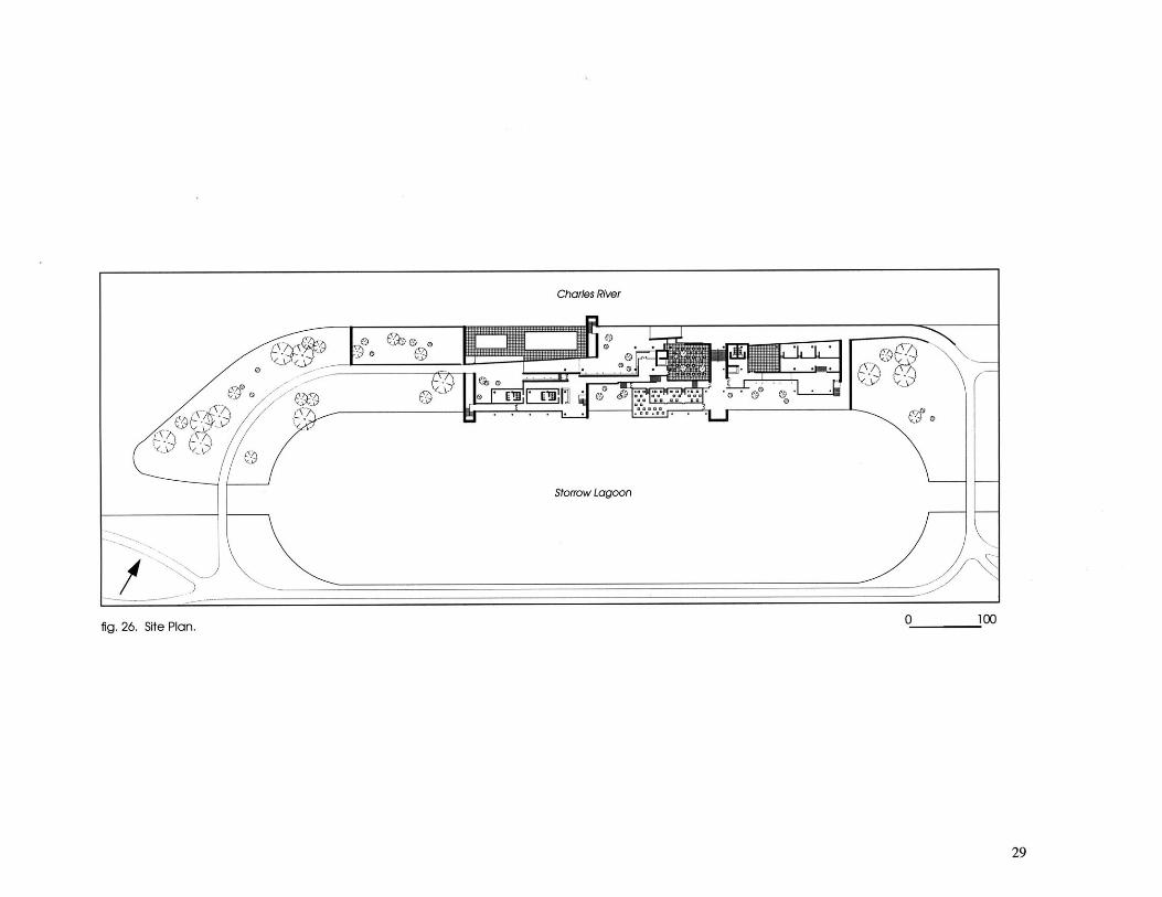
fig. 26. Site Plan. 0 100
29

fig. 27. First Floor Plan.
1. pool2. changing room3. room entrance4. cofe entronce5. cafe6. gallery entrance7. gallery8. bathroom

0
0 0
0

Visual BridgesThe parallel walls provide a physical bridge to the CharlesRiver and the lagoon. At the same time, a visual bridge ispreserved through the change of section and the use ofmaterials.
In order to maintain a visual connection it is necessary tobuild down into, and not up on, the site. Yet, the Esplanadeis a place where people go to be outside and not under-ground. By damming the lagoon it is possible to lower thelevel of its water. By lowering the level of water, the sectiondrops below the level of the Charles River. With the landnow at a lower elevation it is possible to build up withoutblocking the view from the upper level. As people movethrough the higher levels of the site the building becomesthe instrument through which they can view the lagoon.
On the other hand, on the lagoon side of the site, the viewis denied by the drop in section. As a result, the lagoon sidebecomes an enclave, protected from the activities on the
Charles River side of the site.
Another visual connection to the lagoon is through the con-struction system of the structure. The structure is made up ofa column grid. The territories are defined by one and a halffoot high walls. The walls are used as a base for a moveablepaneling system. The panels are transparent, translucent oropaque depending on the privacy needed.
In the model, a section of the cafe shows a system of pan-els that are a translucent white, transparent blue and, incontrast to the blue, transparent orange. The white panelsmove to provide privacy and block out the sun. The bluepanels hang horizontally above to create a new horizonline and relate to the blue water. The orange panels alongthe corridor set up another rhythm of movement and alongthe water's edge appear as markers for the water. Lookingthrough these transparent layers a new spacial experienceis created without closing down the space with solid walls.

fig. 28. Plan of cafe with section represented in model highlighted, fig. 29. Model of cafe without lower roof.

fig. 30. View from lagoon looking into cafe. fig. 31. View from cafe courtyard looking through structure towards thelagoon.
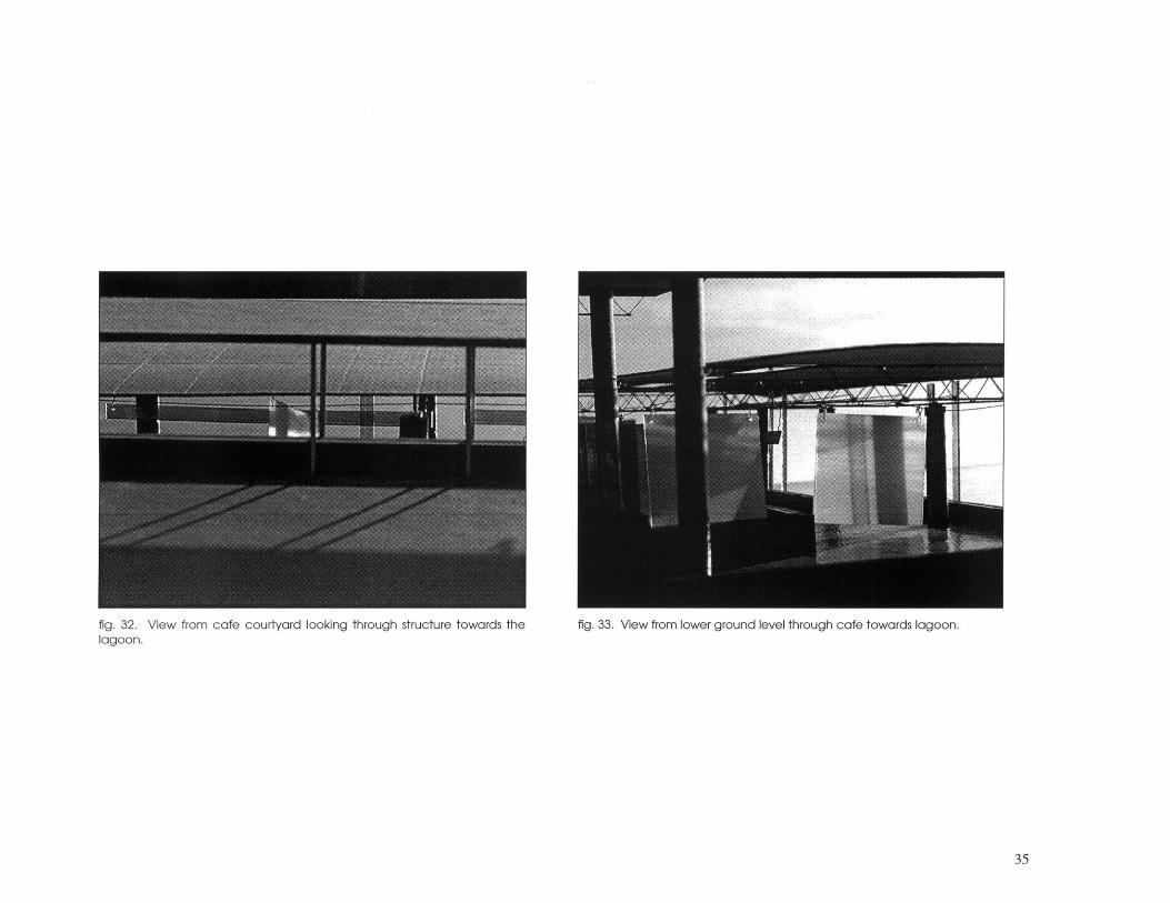
fig. 32. View from cafe courtyard looking through structure towards thelagoon.
fig. 33. View from lower ground level through cafe towards lagoon.

A B C
fig. 34. Section Cuts.
36
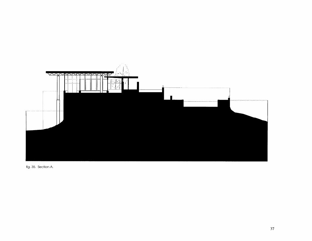
fig. 35. Section A.
37

fig. 36. Section B.
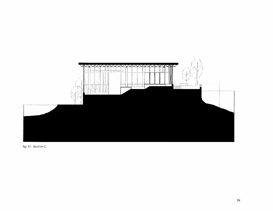
fig. 37. Section C.

Conclusion
The primary goal throughout this thesis was to use the inves-tigation of color and light as a tool with which to developan architectural design. The original question being, couldthe design process be influenced as equally by decisionsconcerning color and light as by the decisions about howto deal with the site, program, materials and structure,
It proved to be more difficult than anticipated. Althoughthe issues of color and light were always at hand, it was diffi-cult to keep them at the forefront of discussion throughoutall phases of the design process. Generally, thoughts aboutcolor and light were secondary to the development of thesite and program. It was easier to incorporate them whenthinking about, for example, materials.
In the end, color and light were dealt with at two distinctpoints of the process. At the larger scale, the decision toincorporate a system of parallel walls that reflected coloredlight not only created the phenomenon desired but also
provided a structure within which the entire project couldbe developed. At the smaller scale, once inside the build-ing, the interaction of color, light and material became amore intimate experience. It was at the scale of my per-sonal experiences in photography.
Perhaps, part of the difficulty of pursuing a thorough investi-gation of color and light was due to a geographical under-standing of the phenomenon. Both the Antonakakises andBarragan come from regions, Greece and Mexico, thathave a history of using materials and colors that recreatethis phenomenon regularly. It is very unlike the tradition inNew England where color is often limited to decorativeuses. Granted color and light exist regardless, but the abilityto manipulate an entire project with these issues constantlyin mind is not a part of the tradition. The challengebecomes bridging one's own regional understanding oflight and color with an exploration that is not necessarilywithin the realm of one's cultural experience.

fig. 38. Longitudinal section with plan.

42

Endnotes & Illustration NotesEndnotes
1. Maxx Hall, The Charles River: The People's River, (Boston:David R. Godine, Publisher, Inc., 1986) pp. 35-38.
2. Hall, pp. 46-47.
3. Hall, p. 50.
4. Hall, p. 51.
Illustration Notes
All Illustrations and photographs are by the author unlessnoted below:
fig. 2. GA Document Vol. 15, December 1986, p. 128.
fig. 3. Atelier 66, ed. Kennith Frampton, (New York: Rizzoli,1985) p. 101.
fig. 4. Armando Salas Portugal, Fotografias de la arquitec-tura de Luis Barragan (Barcelona: Editorial Gustavo Gili,S.A., 1992) p. 136.
fig. 5. Maxx Hall, The Charles River: The People's River, (Bos-ton: David R. Godine, Publisher, Inc., 1986) p. 45.
fig. 6. Hall, p. 50.
fig. 13. Hall, p. 53.

44

Bibliography
Frampton, Kenneth, Editor, Atelier 66, New York: Rizzoli, 1985.
Futagawa, Yokio, Editor, GA Document Vol. 15, December1986.
Hall, Maxx, The Charles River: The People's River Boston:David R. Godine, Publisher, Inc., 1986.
Portugal, Armando Salas, Fotograflas de la arquitectura deLuis Barragan, Barcelona: Editorial Gustavo Gili, S.A., 1992.