Embed Size (px)
Citation preview
A Design Guidefor Westmoreland, Avondale East, Avondale West & Audubon Place
in Montrose
City of HoustonDepartment of Planning & Development
Houston’s Historic Districts
MayorBill White
ControllerAnnise Parker
City Council MembersDistrict ADistrict BDistrict CDistrict DDistrict EDistrict FDistrict GDistrict HDistrict IAt Large Position 1 At Large Position 2At Large Position 3At Large Position 4At Large Position 5
Toni LawrenceJarvis JohnsonAnne ClutterbuckWanda AdamsMike SullivanM.J. KhanPam HolmEdward GonzalezJames G, RodriguezPeter BrownSue LovellMelissa NoriegaRonald GreenJolanda “Jo” Jones
Dear Citizens,
Every great City has historic central neighborhoods that refl ect its history, architecture and culture. One of Houston’s is Montrose, an area of eclectic neighborhoods and people. It refl ects and shows the evolution of Houston from the early twen-tieth century to the present. Montrose’s core neighborhoods Avondale East, Avondale West, Westmoreland and Audubon Place, all City designated Historic Districts, provide an interesting mix of magnifi cent large homes and charming bungalows and of tree lined residential streets and grand boulevards. Its walkable nature gives the resident and visitor the opportunity to stroll from residences to businesses to restaurants.
No wonder Montrose was named in 2009 as “One of the Ten Best Neighborhoods in the United States” by the American Planning Association!
The Design Guidelines presented in this book will give those that are considering renovation, restoration and even addi-tions and new construction, assistance in determining how best to compliment the building at hand and thus enhance the neigh-borhood through the design process.
Thank you for preserving our history, architecture and character for the future.
Sincerely,Bill WhiteMayor
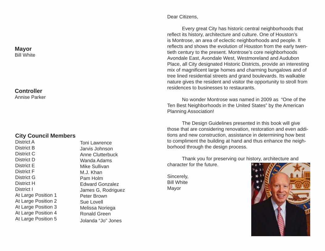
Table of Contents (i) The Purpose of This Design Guide (ii) Defi nition of an Historic District (iii) A. “Appropriate” additions to existing buildings (iv) B. “Compatible” new construction PART ONE (v) Introduction * The Move to the Suburbs
PART TWO (vi) Diversity in Scale, Form, Materials & Historic References (vii) The Historic Districts: * Westmoreland Historic District * Avondale East & West Historic Districts * Audubon Place Historic District (viii) Design Guide
1
THE PURPOSE OF THIS DESIGN GUIDE
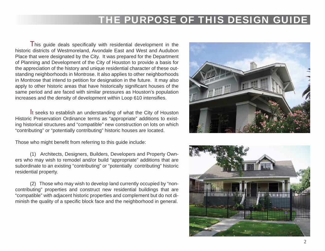
This guide deals specifi cally with residential development in the historic districts of Westmoreland, Avondale East and West and Audubon Place that were designated by the City. It was prepared for the Department of Planning and Development of the City of Houston to provide a basis for the appreciation of the history and unique residential character of these out-standing neighborhoods in Montrose. It also applies to other neighborhoods in Montrose that intend to petition for designation in the future. It may also apply to other historic areas that have historically signifi cant houses of the same period and are faced with similar pressures as Houston’s population increases and the density of development within Loop 610 intensifi es.
It seeks to establish an understanding of what the City of Houston Historic Preservation Ordinance terms as “appropriate” additions to exist-ing historical structures and “compatible” new construction on lots on which “contributing” or “potentially contributing” historic houses are located.
Those who might benefi t from referring to this guide include:
(1) Architects, Designers, Builders, Developers and Property Own-ers who may wish to remodel and/or build “appropriate” additions that are subordinate to an existing “contributing” or “potentially contributing” historic residential property.
(2) Those who may wish to develop land currently occupied by “non-contributing” properties and construct new residential buildings that are “compatible” with adjacent historic properties and complement but do not di-minish the quality of a specifi c block face and the neighborhood in general.
2
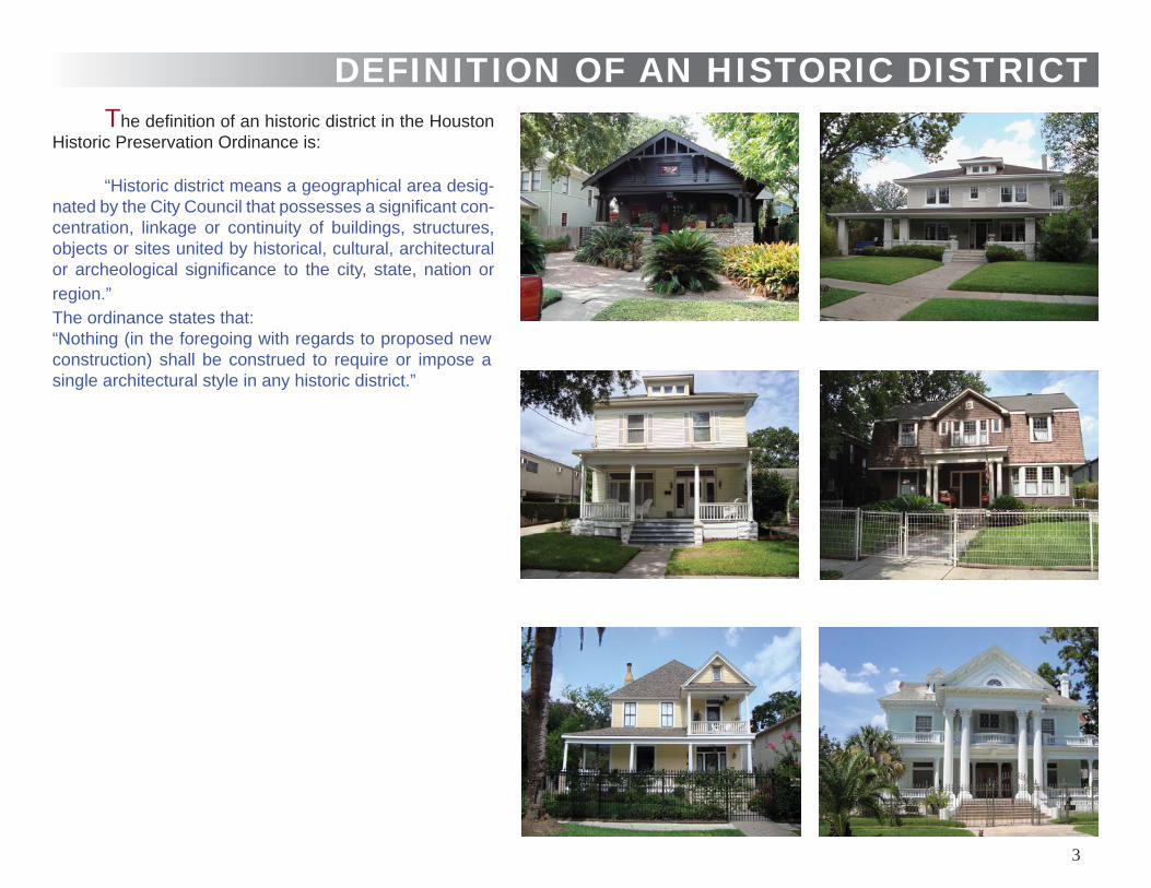
DEFINITION OF AN HISTORIC DISTRICTThe defi nition of an historic district in the Houston
Historic Preservation Ordinance is:
“Historic district means a geographical area desig-nated by the City Council that possesses a signifi cant con-centration, linkage or continuity of buildings, structures, objects or sites united by historical, cultural, architectural or archeological signifi cance to the city, state, nation or region.” The ordinance states that:“Nothing (in the foregoing with regards to proposed new construction) shall be construed to require or impose a single architectural style in any historic district.”
3
Abstract City of Houston Historic Preservation Ordinance No.95-228
A. Appropriate / Compatible Additions to Existing Buildings and Sites The Ordinance created the Houston Archeologial and His-torical Commission (HAHC) whose responsibilities for existing buildings, structures or sites include :* identifying buildings , structures, objects, sites that have the potential for designation as landmarks and historic districts* initiating the process for designation of individual landmarks and historic districts* increasing public awareness of the value of historical archi-tectural conservation* granting or denying an application for a certifi cate of ap-propriateness for alteration, rehabilitation or construction of an ex-terior feature of (i) any landmark (ii) protected landmark (iii) any building or structure in an historic districtTo be deemed appropriate for a certifi cate of appropriateness, the application would have to satisfy a number of criteria including:
(a) the proposed activity must retain and preserve the historical character of the property
(b) the proposed activity must preserve the distinguishing qual-ities or character of the building, structure or site as a product of its own time and avoid alterations that seek to create an earlier of later appearance
(c) the proposed activity must maintain or replicate distinctive stylistic exterior features or examples of skilled craftsmanship that characterizes the building, structure or object or site
(d) new materials to be used for any exterior feature must be compatible with the materials being replaced in composition, de-sign , texture and other visual qualities
(e) the proposed replacement of missing exterior features , if any, should be an accurate duplication …substantiated by avail-able historical, physical or pictorial evidence and …not on conjec-tural designs
(f) proposed design for alterations or construction must ..... be compatible with the size, scale, material and character of the prop-erty in which it is located
(g) the setback of any proposed construction or alteration must be compatible with existing setbacks along the blockface and fac-ing blockface(s)
Abstract City of Houston Historic Preservation Ordinance No.95-228
B. Compatible New Construction For new construction in a designated historic district, the HAHC’s criteria for a Certifi cate of Appropriateness includes:
(a) the new construction must be compatible with the setbacks along the blockface and facing blockface(s)
(b) the exterior features of new construction must be compat-ible with the exterior features of structures along the blockface or facing blockface(s)
(c ) the proportions of the new construction, including height, width, lengths and roofl ine must be compatible with structures and objects along the blockface or blockface(s)
4
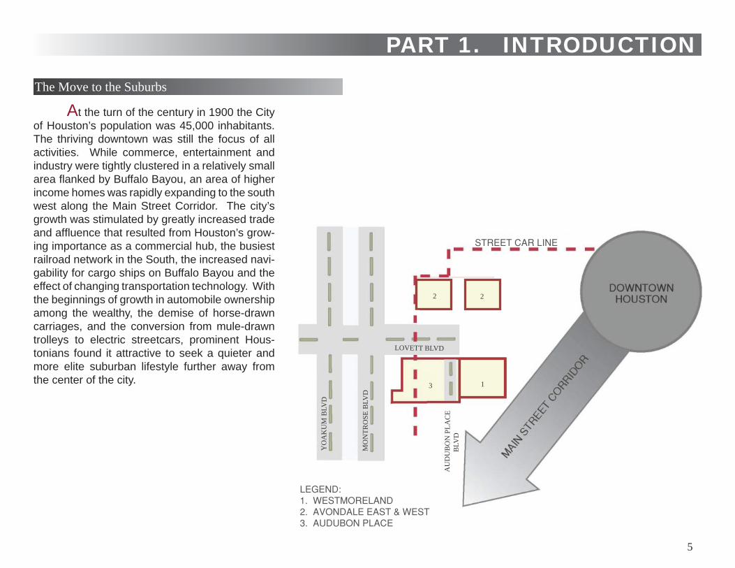
At the turn of the century in 1900 the City of Houston’s population was 45,000 inhabitants. The thriving downtown was still the focus of all activities. While commerce, entertainment and industry were tightly clustered in a relatively small area fl anked by Buffalo Bayou, an area of higher income homes was rapidly expanding to the south west along the Main Street Corridor. The city’s growth was stimulated by greatly increased trade and affl uence that resulted from Houston’s grow-ing importance as a commercial hub, the busiest railroad network in the South, the increased navi-gability for cargo ships on Buffalo Bayou and the effect of changing transportation technology. With the beginnings of growth in automobile ownership among the wealthy, the demise of horse-drawn carriages, and the conversion from mule-drawn trolleys to electric streetcars, prominent Hous-tonians found it attractive to seek a quieter and more elite suburban lifestyle further away from the center of the city.
PART 1. INTRODUCTIONThe Move to the Suburbs
AU
DU
BO
N P
LAC
E
BLV
D
YO
AK
UM
BLV
D
MO
NTR
OSE
BLV
D
LOVETT BLVD
2 2
3 1
5
The city’s fi rst large scale restricted, planned subdivision of over a 1000 lots, the Montrose Addition, was platted in 1911 by the Houston Land Corporation owned by John Wiley Link, a prominent Houston businessman. The site was located on fl at open prairie and pasture land adjacent to Westmoreland Ad-dition and included the future Audubon Place and the western sector of Avondale. It was planned on a north/south grid sys-tem of streets with four major boulevards with landscaped es-planades. The boulevards Montrose, Lovett, and Yoakum were directly interlinked. Audubon Place Boulevard, running paral-lel to Montrose was separate and located further to the east. Not only were grand mansions constructed along Montrose and Lovett, but an ambitious landscape plan including the planting of 4,000 evergreen shade and palm trees lined and united all streets and boulevards. The development was designed to at-tract and serve a more diverse range of income groups than its gated predecessors. At the time the development of Montrose Addition was initiated the Galveston, Houston and San Antonio Railroad traversed the area later known as Audubon Place. It had previously formed the western limit of Houston’s suburban growth. This railway land was redeveloped for residential use and shortly after streetcar lines were extended from downtown to conveniently serve all the new suburban developments.
The Audubon Place neighborhood, formed a part of the larger Montrose Addition. It, like Westmoreland, had Hawthorne Street as its northern boundary. The lots to the east of Audu-bon Place Boulevard, its eastern boundary were contiguous with Westmoreland. West Alabama was its southern boundary and Montrose Boulevard its western boundary. Audubon Place is one of a number of neighborhoods in the Montrose Addition that later sought to establish its own identity.
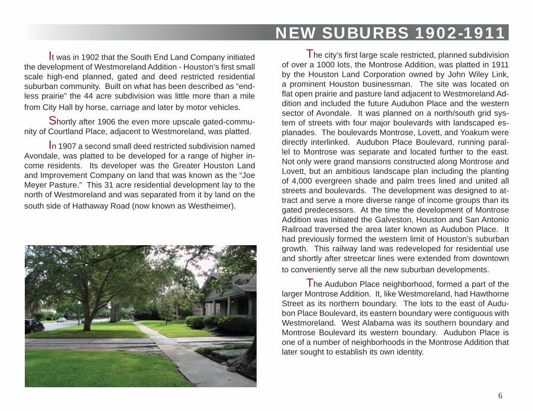
It was in 1902 that the South End Land Company initiated the development of Westmoreland Addition - Houston’s fi rst small scale high-end planned, gated and deed restricted residential suburban community. Built on what has been described as “end-less prairie” the 44 acre subdivision was little more than a mile from City Hall by horse, carriage and later by motor vehicles.
Shortly after 1906 the even more upscale gated-commu-nity of Courtland Place, adjacent to Westmoreland, was platted.
NEW SUBURBS 1902-1911
In 1907 a second small deed restricted subdivision named Avondale, was platted to be developed for a range of higher in-come residents. Its developer was the Greater Houston Land and Improvement Company on land that was known as the “Joe Meyer Pasture.” This 31 acre residential development lay to the north of Westmoreland and was separated from it by land on the south side of Hathaway Road (now known as Westheimer).
6
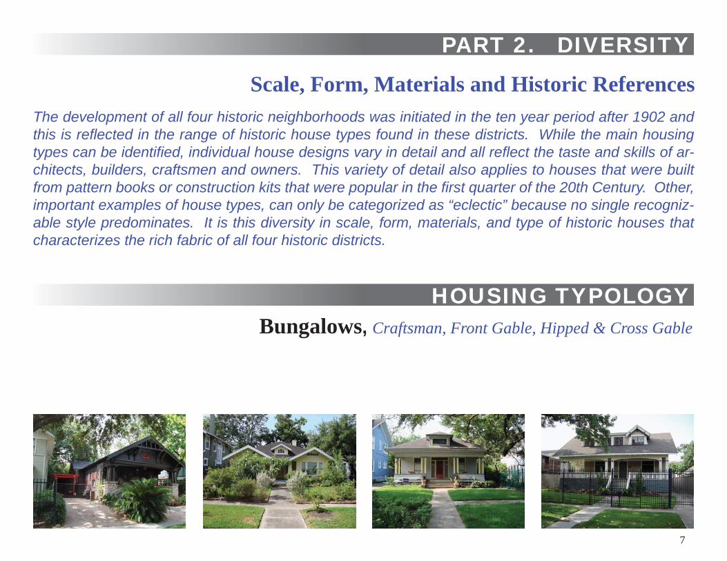
Scale, Form, Materials and Historic ReferencesThe development of all four historic neighborhoods was initiated in the ten year period after 1902 and this is refl ected in the range of historic house types found in these districts. While the main housing types can be identifi ed, individual house designs vary in detail and all refl ect the taste and skills of ar-chitects, builders, craftsmen and owners. This variety of detail also applies to houses that were built from pattern books or construction kits that were popular in the fi rst quarter of the 20th Century. Other, important examples of house types, can only be categorized as “eclectic” because no single recogniz-able style predominates. It is this diversity in scale, form, materials, and type of historic houses that characterizes the rich fabric of all four historic districts.
Bungalows, Craftsman, Front Gable, Hipped & Cross Gable
HOUSING TYPOLOGY
PART 2. DIVERSITY
7
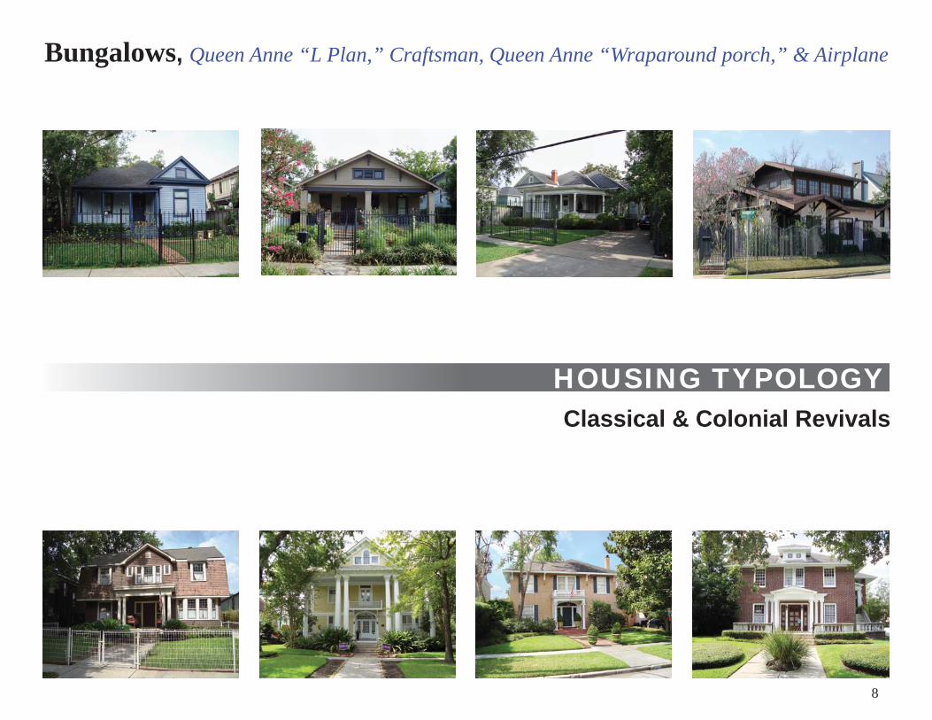
Classical & Colonial RevivalsHOUSING TYPOLOGY
Bungalows, Queen Anne “L Plan,” Craftsman, Queen Anne “Wraparound porch,” & Airplane
8
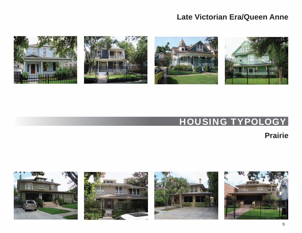
Late Victorian Era/Queen Anne
Prairie
HOUSING TYPOLOGY
9
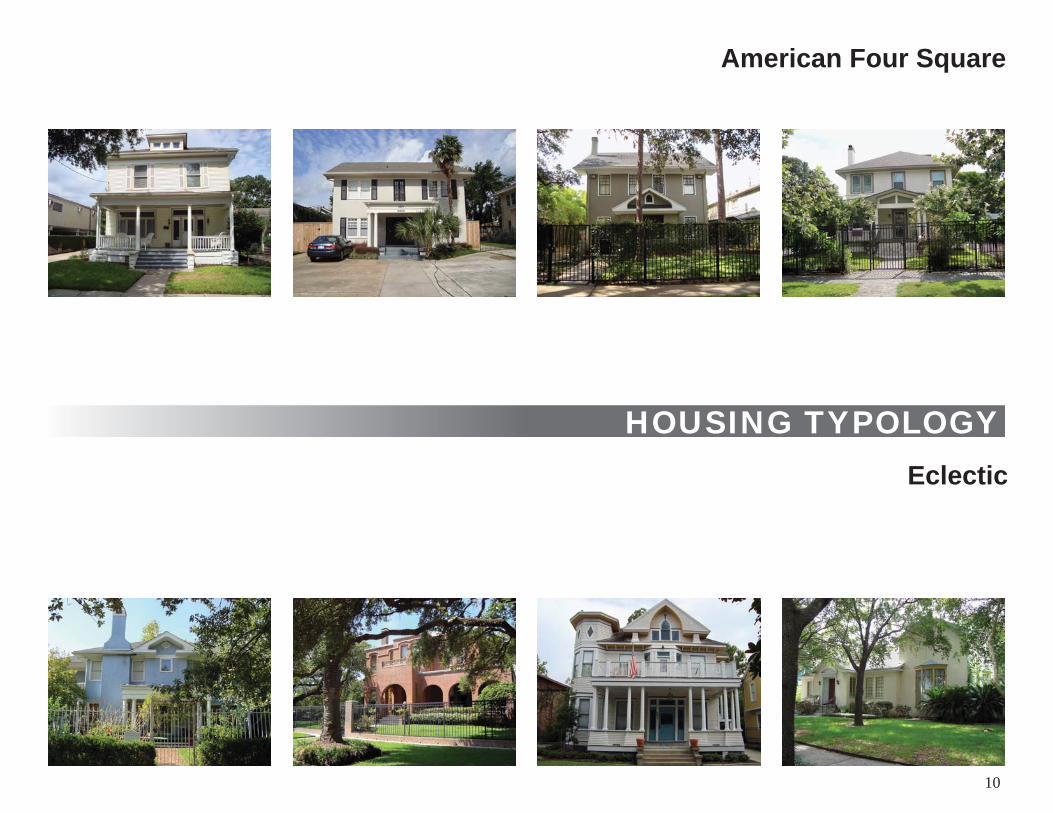
American Four Square
HOUSING TYPOLOGYEclectic
10
THE HISTORIC DISTRICTS
WESTHEIMER
LOVETT BLVD
BRAZO
S
ELGIN
BA
GB
Y
STUART
FRANCIS
HOLMAN
BERRY
WINBERN
SMIT
HLO
UISIA
NA
MIL
AMTR
AVIS
WESTMORELAND
SPU
R 5
27
N
S
EW
WESTMORELAND
MARSHALL
W ALABAMA
SUL ROSS
AU
DU
BO
N
EMERSON
HAWTHORNE
COURTLANDT PLACE BLVD
TAFT
GA
RR
OTT
FLO
RA
BR
AN
DT
BU
TE
JAC
KMARSHALL
KIPLING
HAROLD
0 250 500 FEET
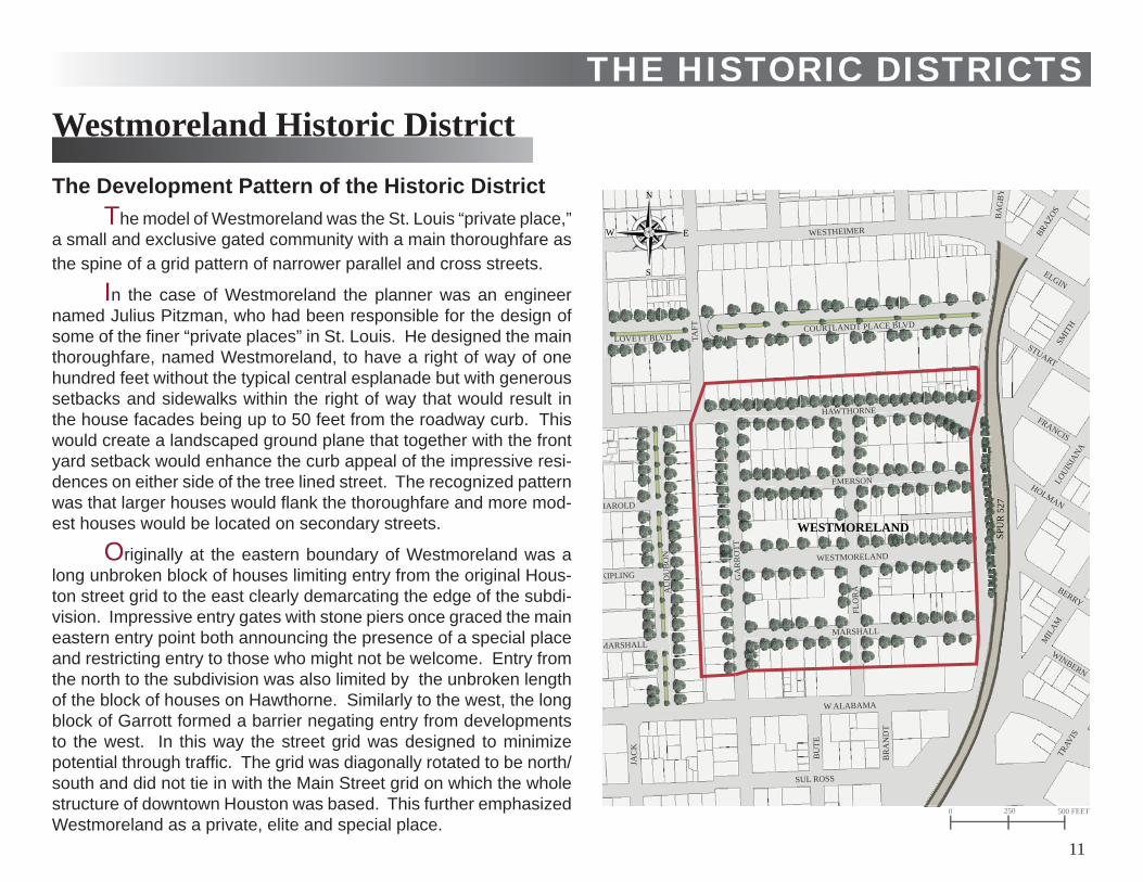
The Development Pattern of the Historic DistrictThe model of Westmoreland was the St. Louis “private place,”
a small and exclusive gated community with a main thoroughfare as the spine of a grid pattern of narrower parallel and cross streets.
In the case of Westmoreland the planner was an engineer named Julius Pitzman, who had been responsible for the design of some of the fi ner “private places” in St. Louis. He designed the main thoroughfare, named Westmoreland, to have a right of way of one hundred feet without the typical central esplanade but with generous setbacks and sidewalks within the right of way that would result in the house facades being up to 50 feet from the roadway curb. This would create a landscaped ground plane that together with the front yard setback would enhance the curb appeal of the impressive resi-dences on either side of the tree lined street. The recognized pattern was that larger houses would fl ank the thoroughfare and more mod-est houses would be located on secondary streets.
Originally at the eastern boundary of Westmoreland was a long unbroken block of houses limiting entry from the original Hous-ton street grid to the east clearly demarcating the edge of the subdi-vision. Impressive entry gates with stone piers once graced the main eastern entry point both announcing the presence of a special place and restricting entry to those who might not be welcome. Entry from the north to the subdivision was also limited by the unbroken length of the block of houses on Hawthorne. Similarly to the west, the long block of Garrott formed a barrier negating entry from developments to the west. In this way the street grid was designed to minimize potential through traffi c. The grid was diagonally rotated to be north/south and did not tie in with the Main Street grid on which the whole structure of downtown Houston was based. This further emphasized Westmoreland as a private, elite and special place.
Westmoreland Historic District
11
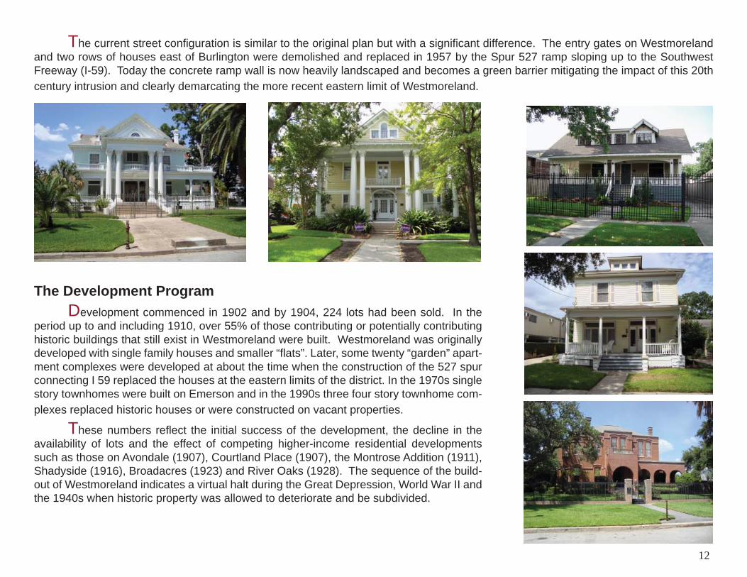
The current street confi guration is similar to the original plan but with a signifi cant difference. The entry gates on Westmoreland and two rows of houses east of Burlington were demolished and replaced in 1957 by the Spur 527 ramp sloping up to the Southwest Freeway (I-59). Today the concrete ramp wall is now heavily landscaped and becomes a green barrier mitigating the impact of this 20th century intrusion and clearly demarcating the more recent eastern limit of Westmoreland.
The Development Program Development commenced in 1902 and by 1904, 224 lots had been sold. In the period up to and including 1910, over 55% of those contributing or potentially contributing historic buildings that still exist in Westmoreland were built. Westmoreland was originally developed with single family houses and smaller “fl ats”. Later, some twenty “garden” apart-ment complexes were developed at about the time when the construction of the 527 spur connecting I 59 replaced the houses at the eastern limits of the district. In the 1970s single story townhomes were built on Emerson and in the 1990s three four story townhome com-plexes replaced historic houses or were constructed on vacant properties.
These numbers refl ect the initial success of the development, the decline in the availability of lots and the effect of competing higher-income residential developments such as those on Avondale (1907), Courtland Place (1907), the Montrose Addition (1911), Shadyside (1916), Broadacres (1923) and River Oaks (1928). The sequence of the build-out of Westmoreland indicates a virtual halt during the Great Depression, World War II and the 1940s when historic property was allowed to deteriorate and be subdivided.
12
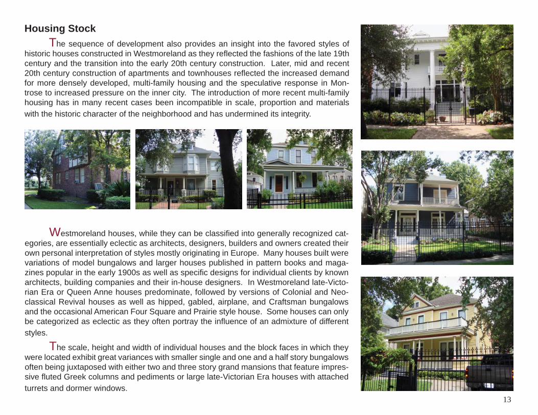
Housing Stock The sequence of development also provides an insight into the favored styles of historic houses constructed in Westmoreland as they refl ected the fashions of the late 19th century and the transition into the early 20th century construction. Later, mid and recent 20th century construction of apartments and townhouses refl ected the increased demand for more densely developed, multi-family housing and the speculative response in Mon-trose to increased pressure on the inner city. The introduction of more recent multi-family housing has in many recent cases been incompatible in scale, proportion and materials with the historic character of the neighborhood and has undermined its integrity.
Westmoreland houses, while they can be classifi ed into generally recognized cat-egories, are essentially eclectic as architects, designers, builders and owners created their own personal interpretation of styles mostly originating in Europe. Many houses built were variations of model bungalows and larger houses published in pattern books and maga-zines popular in the early 1900s as well as specifi c designs for individual clients by known architects, building companies and their in-house designers. In Westmoreland late-Victo-rian Era or Queen Anne houses predominate, followed by versions of Colonial and Neo-classical Revival houses as well as hipped, gabled, airplane, and Craftsman bungalows and the occasional American Four Square and Prairie style house. Some houses can only be categorized as eclectic as they often portray the infl uence of an admixture of different styles. The scale, height and width of individual houses and the block faces in which they were located exhibit great variances with smaller single and one and a half story bungalows often being juxtaposed with either two and three story grand mansions that feature impres-sive fl uted Greek columns and pediments or large late-Victorian Era houses with attached turrets and dormer windows.
13
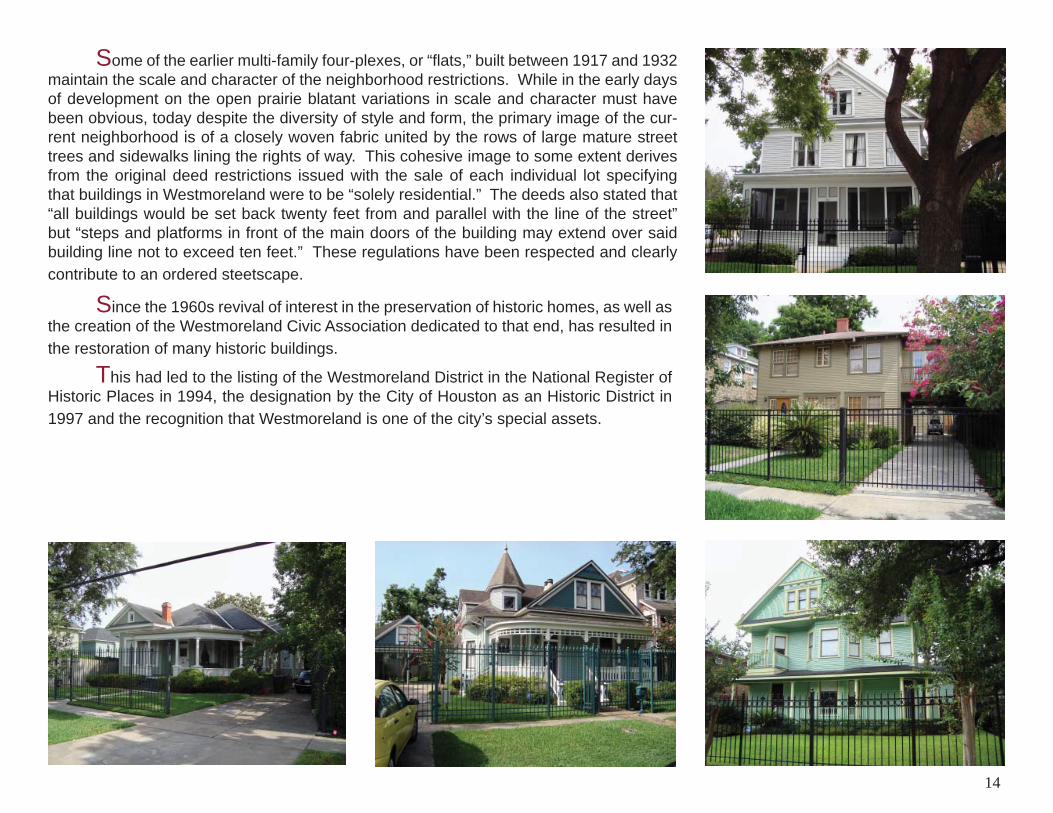
Since the 1960s revival of interest in the preservation of historic homes, as well as the creation of the Westmoreland Civic Association dedicated to that end, has resulted in the restoration of many historic buildings.
This had led to the listing of the Westmoreland District in the National Register of Historic Places in 1994, the designation by the City of Houston as an Historic District in 1997 and the recognition that Westmoreland is one of the city’s special assets.
Some of the earlier multi-family four-plexes, or “fl ats,” built between 1917 and 1932 maintain the scale and character of the neighborhood restrictions. While in the early days of development on the open prairie blatant variations in scale and character must have been obvious, today despite the diversity of style and form, the primary image of the cur-rent neighborhood is of a closely woven fabric united by the rows of large mature street trees and sidewalks lining the rights of way. This cohesive image to some extent derives from the original deed restrictions issued with the sale of each individual lot specifying that buildings in Westmoreland were to be “solely residential.” The deeds also stated that “all buildings would be set back twenty feet from and parallel with the line of the street” but “steps and platforms in front of the main doors of the building may extend over said building line not to exceed ten feet.” These regulations have been respected and clearly contribute to an ordered steetscape.
14
BRAZOS
ELGIN
BA
GB
Y
STUART
FRANCIS
LOUIS
IANA
SMIT
H
HELEN
A
TUAM
ALBANY
AVONDALE EAST
AVONDALE WEST
WESTHEIMER
HAWTHORNE
COURTLANDT PLACE BLVD
EMERSON
GA
RR
OTT
AU
DU
BO
N
HAROLD
STA
NFO
RD
RO
SELA
ND
MO
NTR
OSE
BLV
D
TAFT
MA
SON
AVONDALE
STRATFORD
WH
ITN
EY
GR
AN
T
CALIFORNIA
MISSOURI
PACIFICC
RO
CK
ER
HO
PKIN
S
MO
RG
AN
TAFT
HYDE PARK
BA
LDW
IN
LOVETT BLVD
N
S
EW
AVONDALE
STRATFORD
WESTMORELANDAUDUBON PLACE
SPU
R 5
27
0 250 500 FEET
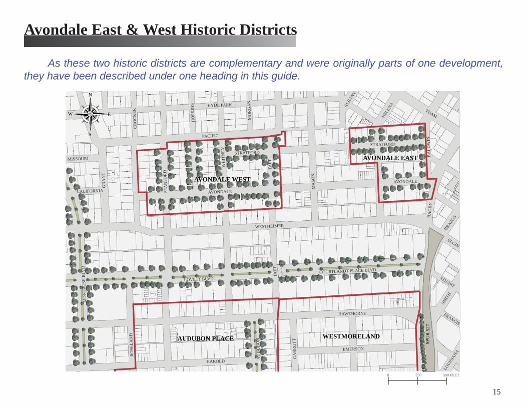
Avondale East & West Historic Districts
As these two historic districts are complementary and were originally parts of one development, they have been described under one heading in this guide.
15
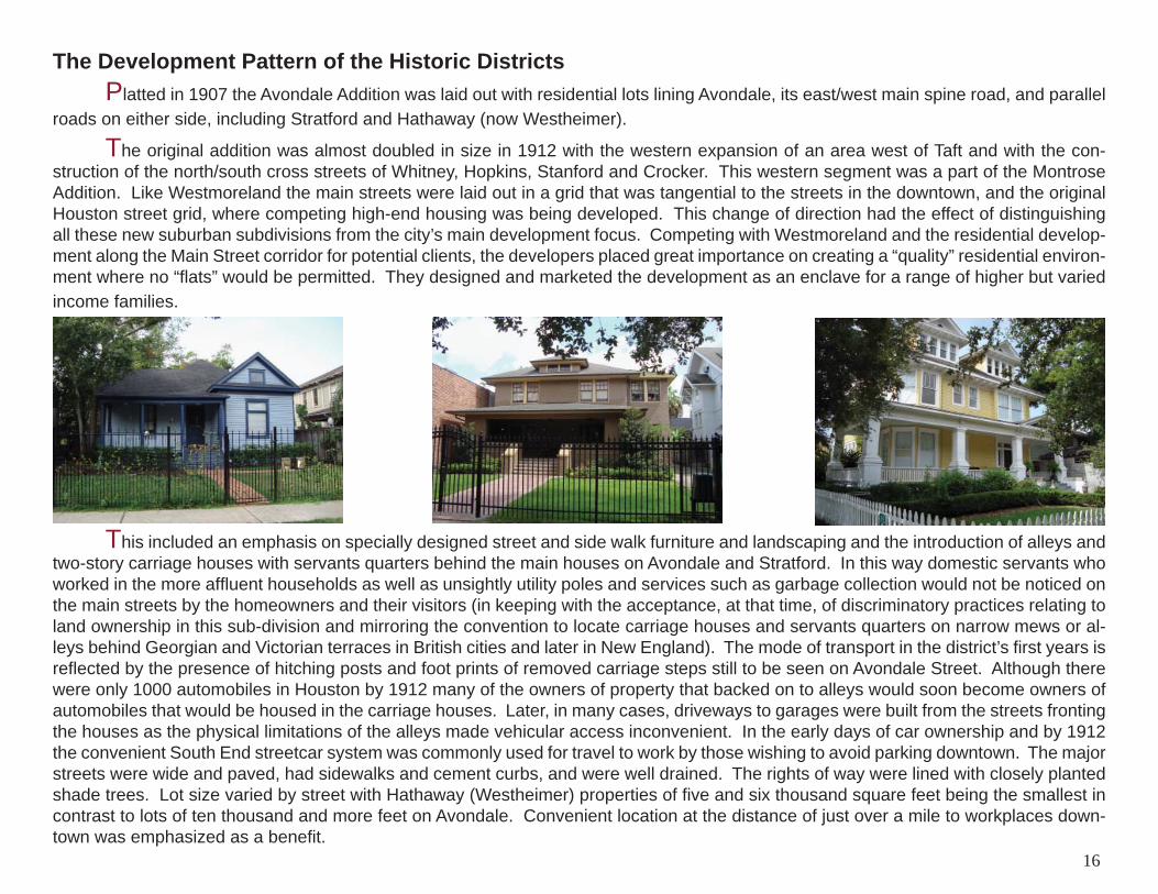
The Development Pattern of the Historic Districts Platted in 1907 the Avondale Addition was laid out with residential lots lining Avondale, its east/west main spine road, and parallel roads on either side, including Stratford and Hathaway (now Westheimer).
The original addition was almost doubled in size in 1912 with the western expansion of an area west of Taft and with the con-struction of the north/south cross streets of Whitney, Hopkins, Stanford and Crocker. This western segment was a part of the Montrose Addition. Like Westmoreland the main streets were laid out in a grid that was tangential to the streets in the downtown, and the original Houston street grid, where competing high-end housing was being developed. This change of direction had the effect of distinguishing all these new suburban subdivisions from the city’s main development focus. Competing with Westmoreland and the residential develop-ment along the Main Street corridor for potential clients, the developers placed great importance on creating a “quality” residential environ-ment where no “fl ats” would be permitted. They designed and marketed the development as an enclave for a range of higher but varied income families.
This included an emphasis on specially designed street and side walk furniture and landscaping and the introduction of alleys and two-story carriage houses with servants quarters behind the main houses on Avondale and Stratford. In this way domestic servants who worked in the more affl uent households as well as unsightly utility poles and services such as garbage collection would not be noticed on the main streets by the homeowners and their visitors (in keeping with the acceptance, at that time, of discriminatory practices relating to land ownership in this sub-division and mirroring the convention to locate carriage houses and servants quarters on narrow mews or al-leys behind Georgian and Victorian terraces in British cities and later in New England). The mode of transport in the district’s fi rst years is refl ected by the presence of hitching posts and foot prints of removed carriage steps still to be seen on Avondale Street. Although there were only 1000 automobiles in Houston by 1912 many of the owners of property that backed on to alleys would soon become owners of automobiles that would be housed in the carriage houses. Later, in many cases, driveways to garages were built from the streets fronting the houses as the physical limitations of the alleys made vehicular access inconvenient. In the early days of car ownership and by 1912 the convenient South End streetcar system was commonly used for travel to work by those wishing to avoid parking downtown. The major streets were wide and paved, had sidewalks and cement curbs, and were well drained. The rights of way were lined with closely planted shade trees. Lot size varied by street with Hathaway (Westheimer) properties of fi ve and six thousand square feet being the smallest in contrast to lots of ten thousand and more feet on Avondale. Convenient location at the distance of just over a mile to workplaces down-town was emphasized as a benefi t.
16
The Development Program The size and scale of residential development (up to 1930 when the deed restrictions lapsed) in the Avondale districts was strongly infl uenced by the imposition of restrictions that dictated the minimum cost that had to be spent on house construction on any specifi c street. In the fi rst decade of 1907-1917 some 35% of those houses still standing today within the boundaries of the two current historic districts were constructed. A signifi cant majority of them were in Avondale East Historic District. In the next decade (1918-1928) another 32% of houses currently in these districts were constructed. The majority of these were built in Avondale West Historic District which to large extent was part of the 1912 expansion of the Avondale Addition of Montrose. Between 1929-1939 only 3% of existing stock were built and only 2% were built between 1939-1950. It is signifi cant that after 1950 some 28% of the existing residential structures were built as this number mostly represents the replacement of historic homes by new and sometimes incompatible multi-family housing.
The above percentages refl ect the success of the initial two decades and the gradual slow down, as the area became built out. The depression period before World War II, was followed by a period of fl ux during and after the war when many of the original families moved away to the suburbs. Historic houses were subdivided to create rental apartments and two storey apartments were built to re-spond to the increased demand to house incoming new families. This was followed by an upsurge in interest in restoring historic homes in the 1970s the consequent improvement in the quality of the neighborhood that was tempered by transition to mixed-use and restaurants and bars on the periphery of the area. The construction of multi-family condominiums and townhouses on sites where historic houses had stood refl ects the demand for housing in a rapidly changing and more urbane Montrose.
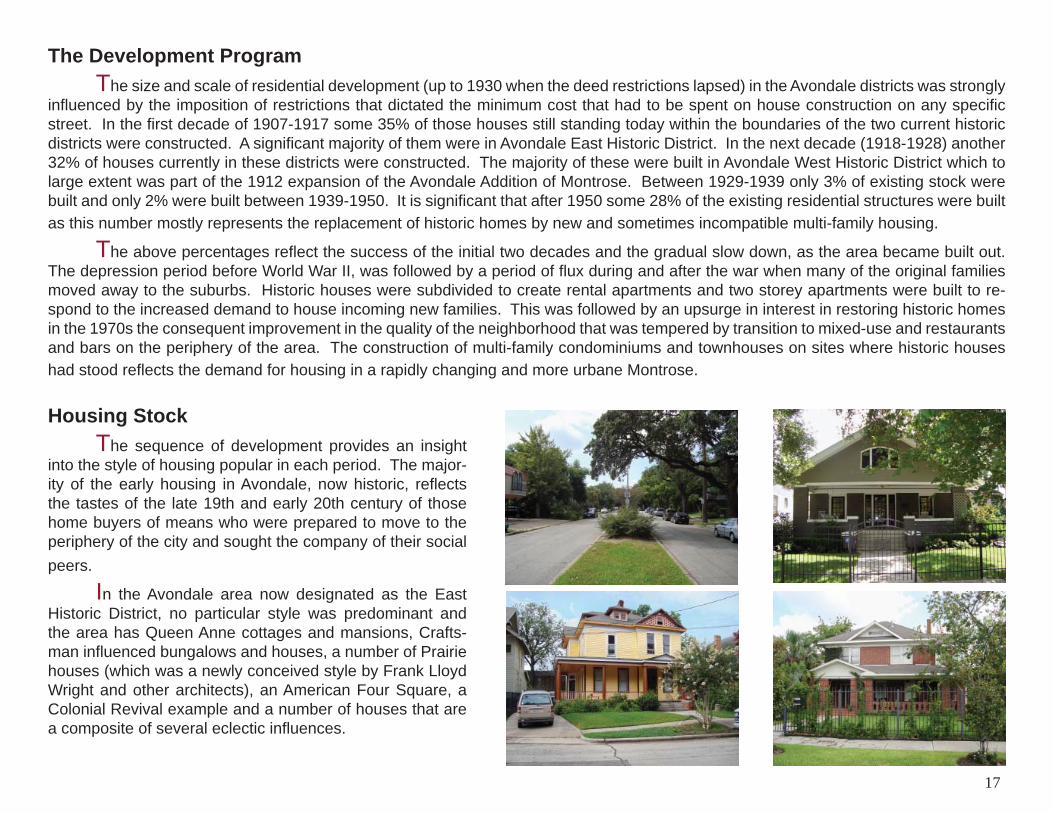
Housing Stock The sequence of development provides an insight into the style of housing popular in each period. The major-ity of the early housing in Avondale, now historic, refl ects the tastes of the late 19th and early 20th century of those home buyers of means who were prepared to move to the periphery of the city and sought the company of their social peers.
In the Avondale area now designated as the East Historic District, no particular style was predominant and the area has Queen Anne cottages and mansions, Crafts-man infl uenced bungalows and houses, a number of Prairie houses (which was a newly conceived style by Frank Lloyd Wright and other architects), an American Four Square, a Colonial Revival example and a number of houses that are a composite of several eclectic infl uences.
17
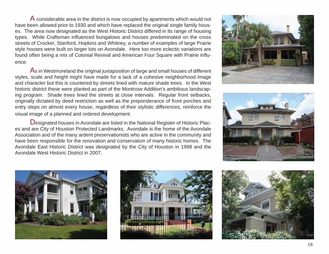
A considerable area in the district is now occupied by apartments which would not have been allowed prior to 1930 and which have replaced the original single family hous-es. The area now designated as the West Historic District differed in its range of housing types. While Craftsman infl uenced bungalows and houses predominated on the cross streets of Crocker, Stanford, Hopkins and Whitney, a number of examples of large Prairie style houses were built on larger lots on Avondale. Here too more eclectic variations are found often being a mix of Colonial Revival and American Four Square with Prairie infl u-ence.
As in Westmoreland the original juxtaposition of large and small houses of different styles, scale and height might have made for a lack of a cohesive neighborhood image and character but this is countered by streets lined with mature shade trees. In the West historic district these were planted as part of the Montrose Addition’s ambitious landscap-ing program. Shade trees lined the streets at close intervals. Regular front setbacks, originally dictated by deed restriction as well as the preponderance of front porches and entry steps on almost every house, regardless of their stylistic differences, reinforce the visual image of a planned and ordered development.
Designated houses in Avondale are listed in the National Register of Historic Plac-es and are City of Houston Protected Landmarks. Avondale is the home of the Avondale Association and of the many ardent preservationists who are active in the community and have been responsible for the renovation and conservation of many historic homes. The Avondale East Historic District was designated by the City of Houston in 1998 and the Avondale West Historic District in 2007.
18
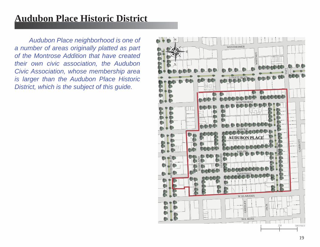
Audubon Place neighborhood is one of a number of areas originally platted as part of the Montrose Addition that have created their own civic association, the Audubon Civic Association, whose membership area is larger than the Audubon Place Historic District, which is the subject of this guide.
AUDUBON PLACE
MARSHALL
KIPLING
HAROLD
AU
DU
BO
N
W ALABAMA
HAWTHORNE
SUL ROSS
LOVETT BLVD
STA
NFO
RD
RO
SELA
ND
MO
NTR
OSE
BLV
D
GA
RR
OTT
WESTHEIMER
TAFT
WH
ITN
EY
JAC
K
GR
EELE
Y
0 250 500 FEET
N
S
EW
Audubon Place Historic District
19
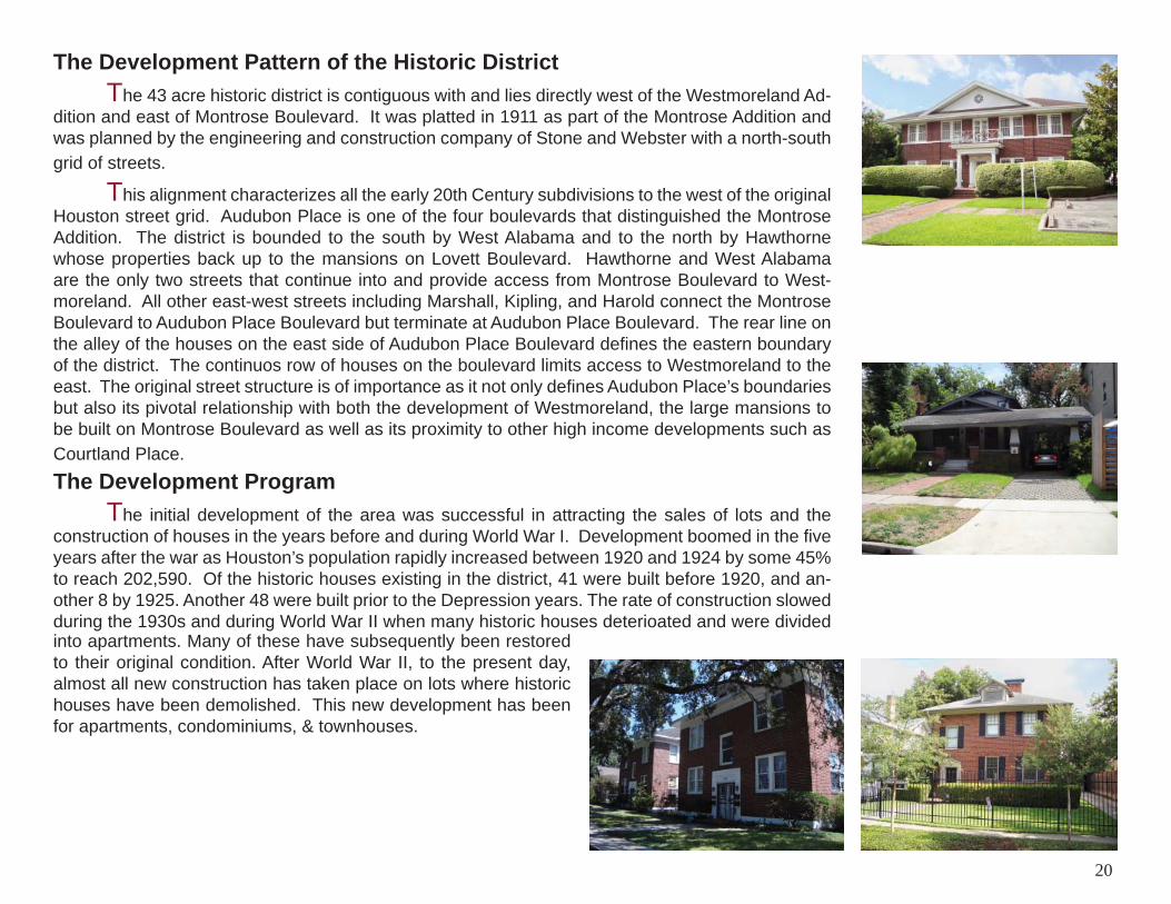
The Development Pattern of the Historic District The 43 acre historic district is contiguous with and lies directly west of the Westmoreland Ad-dition and east of Montrose Boulevard. It was platted in 1911 as part of the Montrose Addition and was planned by the engineering and construction company of Stone and Webster with a north-south grid of streets.
This alignment characterizes all the early 20th Century subdivisions to the west of the original Houston street grid. Audubon Place is one of the four boulevards that distinguished the Montrose Addition. The district is bounded to the south by West Alabama and to the north by Hawthorne whose properties back up to the mansions on Lovett Boulevard. Hawthorne and West Alabama are the only two streets that continue into and provide access from Montrose Boulevard to West-moreland. All other east-west streets including Marshall, Kipling, and Harold connect the Montrose Boulevard to Audubon Place Boulevard but terminate at Audubon Place Boulevard. The rear line on the alley of the houses on the east side of Audubon Place Boulevard defi nes the eastern boundary of the district. The continuos row of houses on the boulevard limits access to Westmoreland to the east. The original street structure is of importance as it not only defi nes Audubon Place’s boundaries but also its pivotal relationship with both the development of Westmoreland, the large mansions to be built on Montrose Boulevard as well as its proximity to other high income developments such as Courtland Place.The Development Program The initial development of the area was successful in attracting the sales of lots and the construction of houses in the years before and during World War I. Development boomed in the fi ve years after the war as Houston’s population rapidly increased between 1920 and 1924 by some 45% to reach 202,590. Of the historic houses existing in the district, 41 were built before 1920, and an-other 8 by 1925. Another 48 were built prior to the Depression years. The rate of construction slowed during the 1930s and during World War II when many historic houses deterioated and were divided
20
into apartments. Many of these have subsequently been restored to their original condition. After World War II, to the present day, almost all new construction has taken place on lots where historic houses have been demolished. This new development has been for apartments, condominiums, & townhouses.
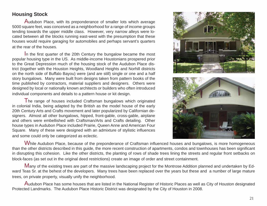
Housing Stock Audubon Place, with its preponderance of smaller lots which average 5000 square feet, was conceived as a neighborhood for a range of income groups tending towards the upper middle class. However, very narrow alleys were lo-cated between all the blocks running east-west with the presumption that these houses would require garaging for automobiles and perhaps servant’s quarters at the rear of the houses.
In the fi rst quarter of the 20th Century the bungalow became the most popular housing type in the US. As middle-income Houstonians prospered prior to the Great Depression much of the housing stock of the Audubon Place dis-trict (together with the Houston Heights, Woodland Heights and Norhill districts on the north side of Buffalo Bayou) were (and are still) single or one and a half story bungalows. Many were built from designs taken from pattern books of the time published by contractors, material suppliers and designers. Others were designed by local or nationally known architects or builders who often introduced individual components and details to a pattern house or kit design.
The range of houses included Craftsman bungalows which originated in colonial India, being adapted by the British as the model house of the early 20th Century Arts and Crafts movement and later popularized by Californian de-signers. Almost all other bungalows, hipped, front-gable, cross-gable, airplane and others were embellished with Craftsman/Arts and Crafts detailing. Other house types in Audubon Place included Prairie, Queen Anne and American Four Square. Many of these were designed with an admixture of stylistic infl uences and some could only be categorized as eclectic.
While Audubon Place, because of the preponderance of Craftsman infl uenced houses and bungalows, is more homogeneous than the other districts described in this guide, the more recent construction of apartments, condos and townhouses has been signifi cant in disrupting this cohesion. Like the other districts, the planting of rows of shade trees lining the streets and regular front setbacks on block-faces (as set out in the original deed restrictions) create an image of order and street containment.
Many of the existing trees are part of the massive landscaping project for the Montrose Addition planned and undertaken by Ed-ward Teas Sr. at the behest of the developers. Many trees have been replaced over the years but these and a number of large mature trees, on private property, visually unify the neighborhood.
Audubon Place has some houses that are listed in the National Register of Historic Places as well as City of Houston designated Protected Landmarks. The Audubon Place Historic District was designated by the City of Houston in 2008.
21
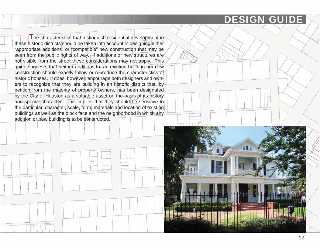
DESIGN GUIDEThe characteristics that distinguish residential development in
these historic districts should be taken into account in designing either “appropriate additions” or “compatible” new construction that may be seen from the public rights of way. If additions or new structures are not visible from the street these considerations may not apply. This guide suggests that neither additions to an existing building nor new construction should exactly follow or reproduce the characteristics of historic houses. It does, however, encourage both designers and own-ers to recognize that they are building in an historic district that, by petition from the majority of property owners, has been designated by the City of Houston as a valuable asset on the basis of its history and special character. This implies that they should be sensitive to the particular, character, scale, form, materials and location of existing buildings as well as the block face and the neighborhood in which any addition or new building is to be constructed.
22
DESIGN GUIDE
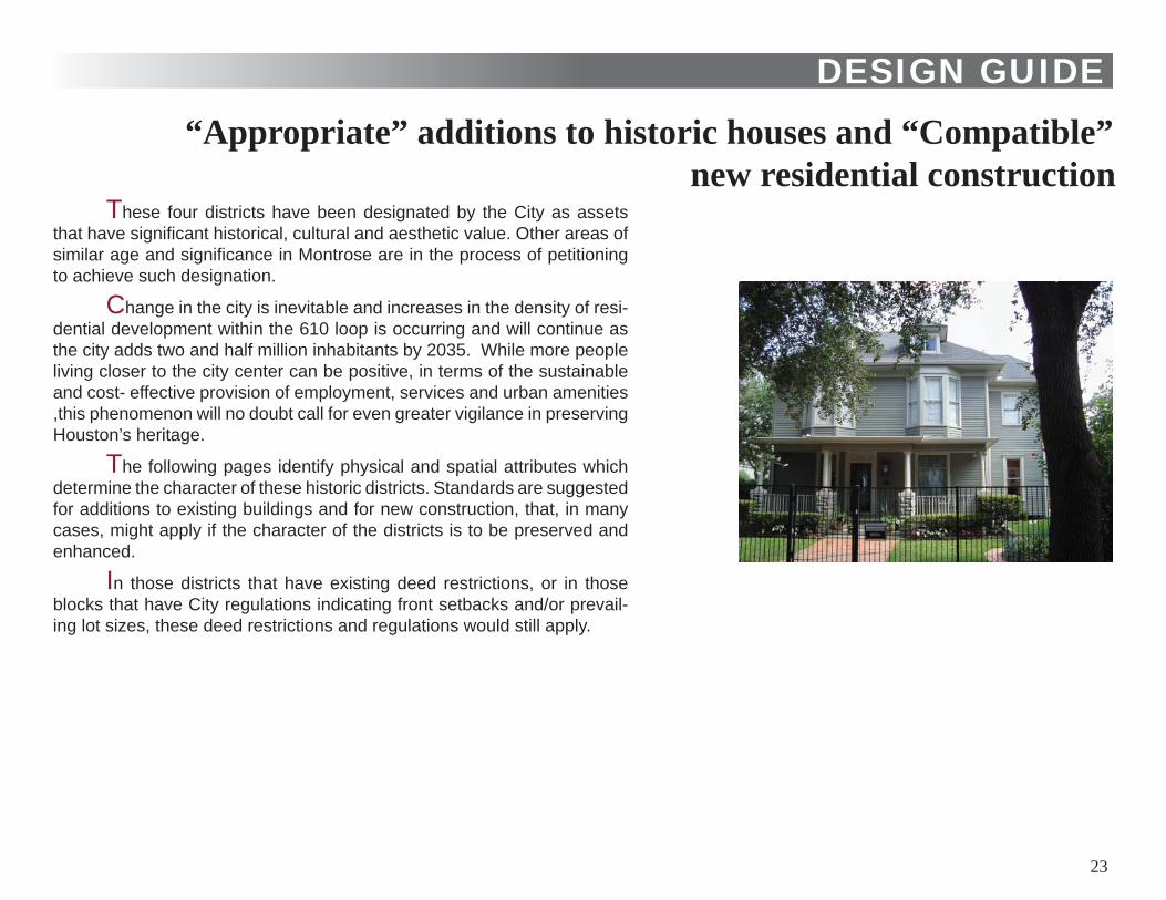
These four districts have been designated by the City as assets that have signifi cant historical, cultural and aesthetic value. Other areas of similar age and signifi cance in Montrose are in the process of petitioning to achieve such designation.
Change in the city is inevitable and increases in the density of resi-dential development within the 610 loop is occurring and will continue as the city adds two and half million inhabitants by 2035. While more people living closer to the city center can be positive, in terms of the sustainable and cost- effective provision of employment, services and urban amenities ,this phenomenon will no doubt call for even greater vigilance in preserving Houston’s heritage.
The following pages identify physical and spatial attributes which determine the character of these historic districts. Standards are suggested for additions to existing buildings and for new construction, that, in many cases, might apply if the character of the districts is to be preserved and enhanced.
In those districts that have existing deed restrictions, or in those blocks that have City regulations indicating front setbacks and/or prevail-ing lot sizes, these deed restrictions and regulations would still apply.
“Appropriate” additions to historic houses and “Compatible” new residential construction
23
PHYSICAL/SPATIAL ATTRIBUTES
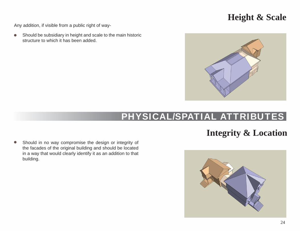
Height & Scale Any addition, if visible from a public right of way-
Should be subsidiary in height and scale to the main historic structure to which it has been added.
Should in no way compromise the design or integrity of the facades of the original building and should be located in a way that would clearly identify it as an addition to that building.
Integrity & Location
24
PHYSICAL/SPATIAL ATTRIBUTES
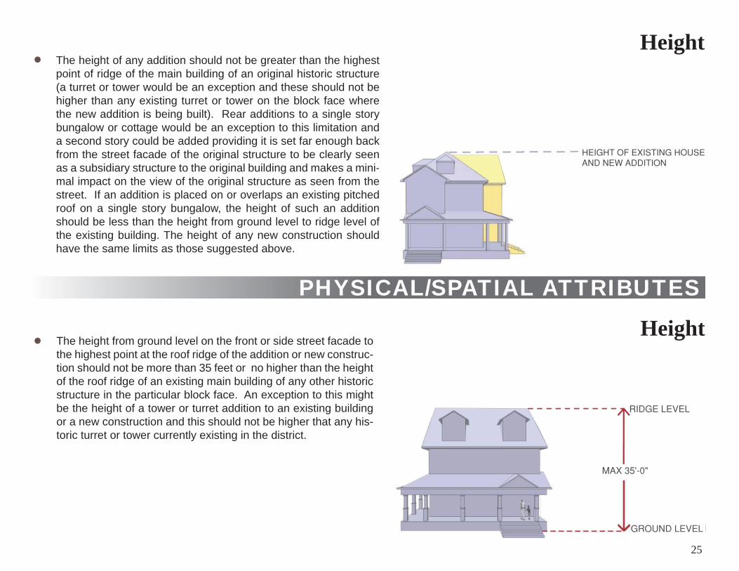
Height The height of any addition should not be greater than the highest point of ridge of the main building of an original historic structure (a turret or tower would be an exception and these should not be higher than any existing turret or tower on the block face where the new addition is being built). Rear additions to a single story bungalow or cottage would be an exception to this limitation and a second story could be added providing it is set far enough back from the street facade of the original structure to be clearly seen as a subsidiary structure to the original building and makes a mini-mal impact on the view of the original structure as seen from the street. If an addition is placed on or overlaps an existing pitched roof on a single story bungalow, the height of such an addition should be less than the height from ground level to ridge level of the existing building. The height of any new construction should have the same limits as those suggested above.
The height from ground level on the front or side street facade to the highest point at the roof ridge of the addition or new construc-tion should not be more than 35 feet or no higher than the height of the roof ridge of an existing main building of any other historic structure in the particular block face. An exception to this might be the height of a tower or turret addition to an existing building or a new construction and this should not be higher that any his-toric turret or tower currently existing in the district.
Height
25
PHYSICAL/SPATIAL ATTRIBUTES
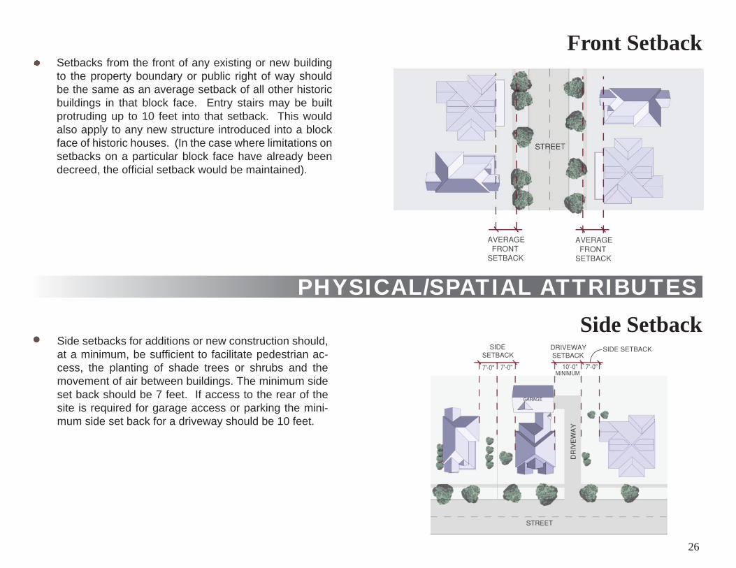
Front Setback Setbacks from the front of any existing or new building to the property boundary or public right of way should be the same as an average setback of all other historic buildings in that block face. Entry stairs may be built protruding up to 10 feet into that setback. This would also apply to any new structure introduced into a block face of historic houses. (In the case where limitations on setbacks on a particular block face have already been decreed, the offi cial setback would be maintained).
Side setbacks for additions or new construction should, at a minimum, be suffi cient to facilitate pedestrian ac-cess, the planting of shade trees or shrubs and the movement of air between buildings. The minimum side set back should be 7 feet. If access to the rear of the site is required for garage access or parking the mini-mum side set back for a driveway should be 10 feet.
Side Setback
26
PHYSICAL/SPATIAL ATTRIBUTES
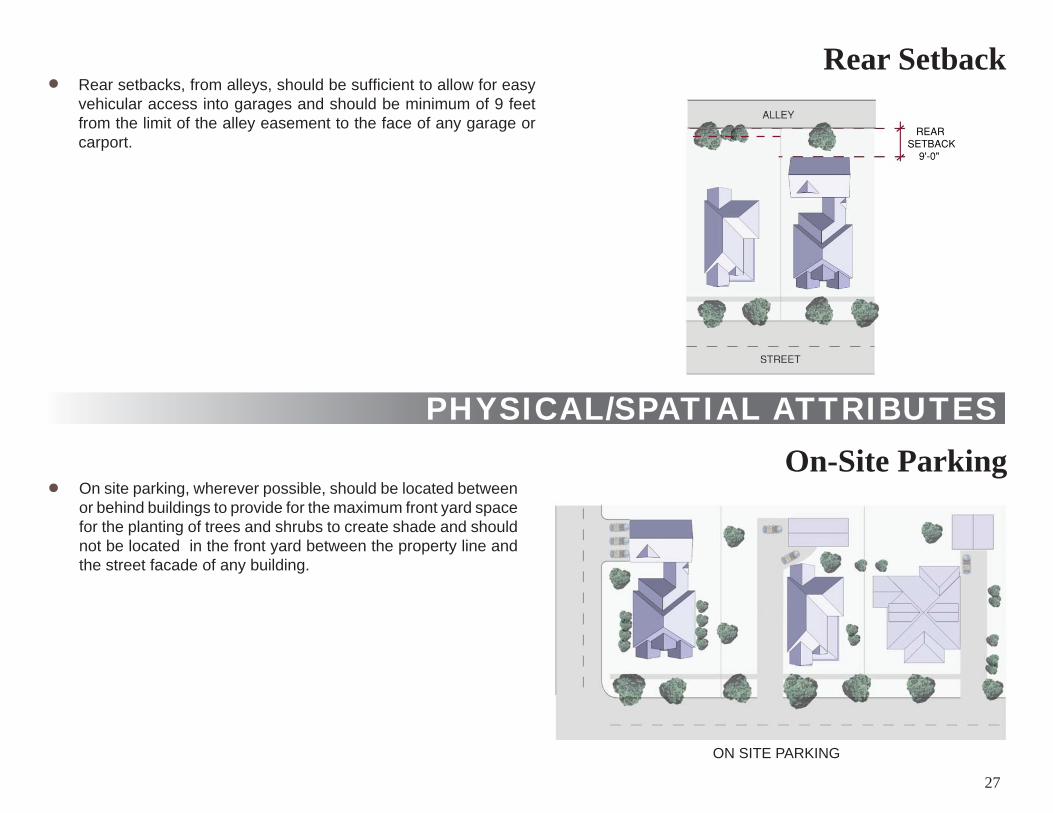
Rear Setback Rear setbacks, from alleys, should be suffi cient to allow for easy vehicular access into garages and should be minimum of 9 feet from the limit of the alley easement to the face of any garage or carport.
On site parking, wherever possible, should be located between or behind buildings to provide for the maximum front yard space for the planting of trees and shrubs to create shade and should not be located in the front yard between the property line and the street facade of any building.
DIAGRAM
On-Site Parking
ON SITE PARKING
27
PHYSICAL/SPATIAL ATTRIBUTES
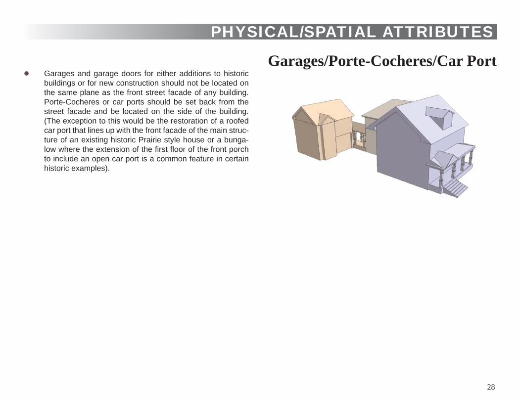
Garages/Porte-Cocheres/Car Port Garages and garage doors for either additions to historic buildings or for new construction should not be located on the same plane as the front street facade of any building. Porte-Cocheres or car ports should be set back from the street facade and be located on the side of the building. (The exception to this would be the restoration of a roofed car port that lines up with the front facade of the main struc-ture of an existing historic Prairie style house or a bunga-low where the extension of the fi rst fl oor of the front porch to include an open car port is a common feature in certain historic examples).
28
PHYSICAL/SPATIAL ATTRIBUTESSite Coverage
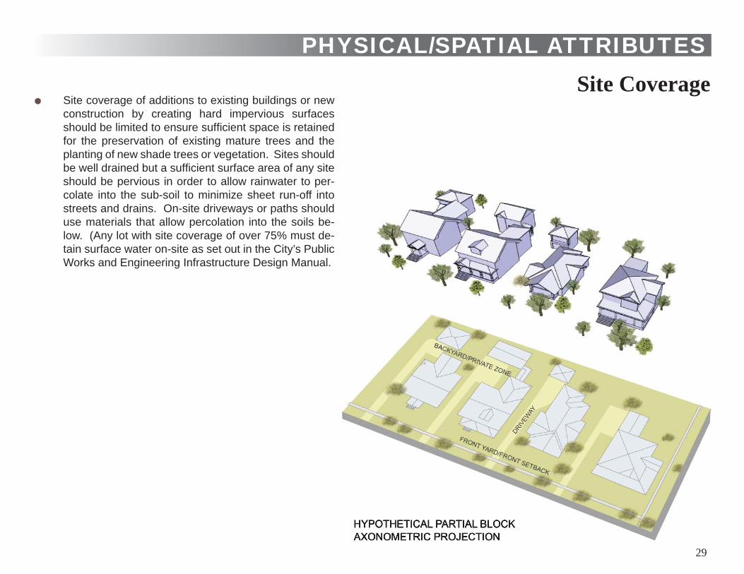
Site coverage of additions to existing buildings or new construction by creating hard impervious surfaces should be limited to ensure suffi cient space is retained for the preservation of existing mature trees and the planting of new shade trees or vegetation. Sites should be well drained but a suffi cient surface area of any site should be pervious in order to allow rainwater to per-colate into the sub-soil to minimize sheet run-off into streets and drains. On-site driveways or paths should use materials that allow percolation into the soils be-low. (Any lot with site coverage of over 75% must de-tain surface water on-site as set out in the City’s Public Works and Engineering Infrastructure Design Manual.
HYPOTHETICAL PARTIAL BLOCKAXONOMETRIC PROJECTION
29
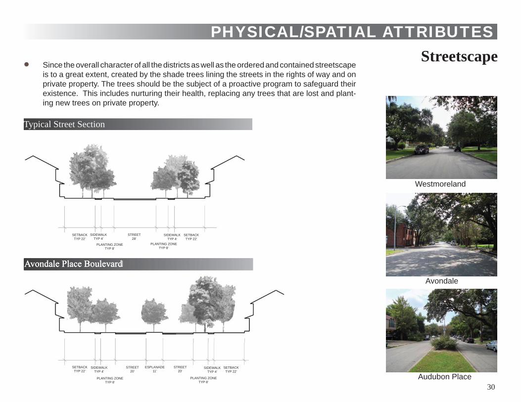
Streetscape Since the overall character of all the districts as well as the ordered and contained streetscape is to a great extent, created by the shade trees lining the streets in the rights of way and on private property. The trees should be the subject of a proactive program to safeguard their existence. This includes nurturing their health, replacing any trees that are lost and plant-ing new trees on private property.
PHYSICAL/SPATIAL ATTRIBUTES
Typical Street Section
Avondale Place Boulevard
Westmoreland
Avondale
Audubon Place 30
SETBACKTYP 22’
SIDEWALKTYP 4’
PLANTING ZONETYP 8’
STREET28’
SETBACKTYP 22’
SIDEWALKTYP 4’
PLANTING ZONETYP 8’
SETBACKTYP 22’
SIDEWALKTYP 4’
PLANTING ZONETYP 8’
STREET20’
SETBACKTYP 22’
SIDEWALKTYP 4’
PLANTING ZONETYP 8’
STREET20’
ESPLANADE11’
HISTORIC CHARACTERISTICS
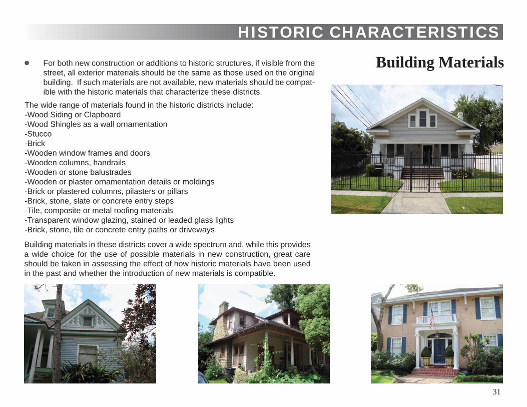
Building Materials
The wide range of materials found in the historic districts include:-Wood Siding or Clapboard-Wood Shingles as a wall ornamentation-Stucco-Brick-Wooden window frames and doors-Wooden columns, handrails-Wooden or stone balustrades-Wooden or plaster ornamentation details or moldings-Brick or plastered columns, pilasters or pillars-Brick, stone, slate or concrete entry steps-Tile, composite or metal roofi ng materials-Transparent window glazing, stained or leaded glass lights -Brick, stone, tile or concrete entry paths or driveways
Building materials in these districts cover a wide spectrum and, while this provides a wide choice for the use of possible materials in new construction, great care should be taken in assessing the effect of how historic materials have been used in the past and whether the introduction of new materials is compatible.
For both new construction or additions to historic structures, if visible from the street, all exterior materials should be the same as those used on the original building. If such materials are not available, new materials should be compat-ible with the historic materials that characterize these districts.
31

The facades of all historic houses in these districts, while they can be classifi ed according to housing types, are diverse both in style and character. None of these houses have main street facades designed with a single vertical plane. Irregular fl oor plans, pitched roofs, exposed rafters and eaves, roof overhangs, roofed and open porches, porticos, columns, pilasters and pediments, balustrades, bay and oriel windows, shingled ornamentation, inset window frames and framed openings create an array of interacting planes that give depth and interest to these facades. These articulated and juxtaposed components enrich the visual experience. In keeping with the historical references of a particular type of house or outbuilding, street facades of any new additions to these houses or the facades of new construction should be designed to complement the special character of the district.
HISTORIC CHARACTERISTICS
Articulation
Pitched RoofsAll historic housing types in these specifi c districts have pitched roofs. While they may vary dramatically in pitch, according to the house type, they are an important element in establishing the historic character of these districts. In any addition to an existing his-toric house or in the design of new construction, the form and pitch of new roofs should take this into account. Flat roofs or shed type roofs are not found in these historic districts, and if they can be seen from the street, they are potentially out of character with adjacent property.
32
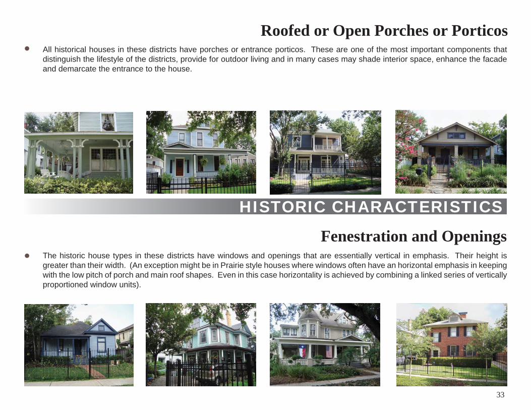
All historical houses in these districts have porches or entrance porticos. These are one of the most important components that distinguish the lifestyle of the districts, provide for outdoor living and in many cases may shade interior space, enhance the facade and demarcate the entrance to the house.
HISTORIC CHARACTERISTICS
Roofed or Open Porches or Porticos
Fenestration and OpeningsThe historic house types in these districts have windows and openings that are essentially vertical in emphasis. Their height is greater than their width. (An exception might be in Prairie style houses where windows often have an horizontal emphasis in keeping with the low pitch of porch and main roof shapes. Even in this case horizontality is achieved by combining a linked series of vertically proportioned window units).
33
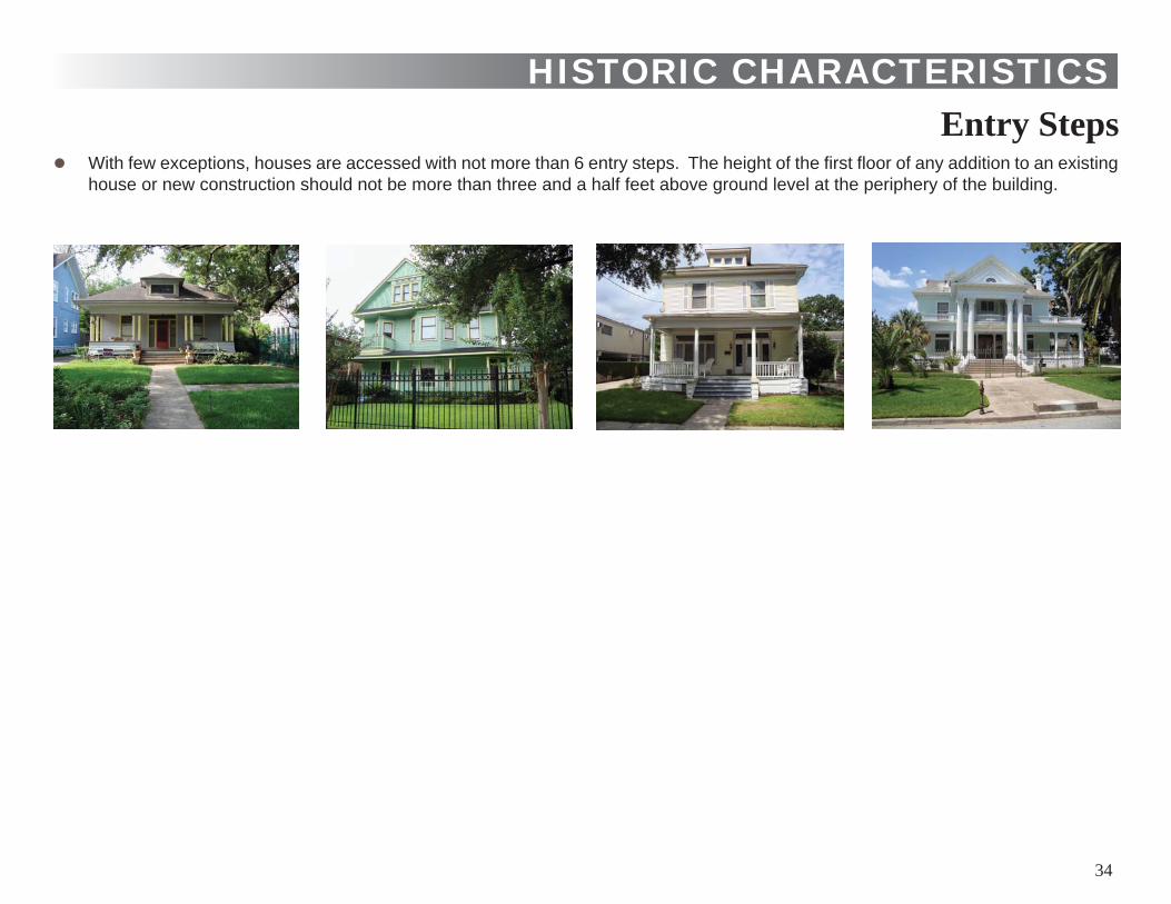
With few exceptions, houses are accessed with not more than 6 entry steps. The height of the fi rst fl oor of any addition to an existing house or new construction should not be more than three and a half feet above ground level at the periphery of the building.
HISTORIC CHARACTERISTICSEntry Steps
34
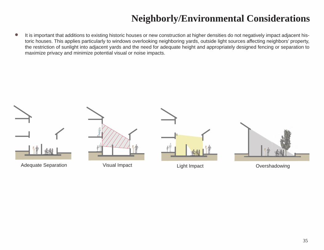
It is important that additions to existing historic houses or new construction at higher densities do not negatively impact adjacent his-toric houses. This applies particularly to windows overlooking neighboring yards, outside light sources affecting neighbors’ property, the restriction of sunlight into adjacent yards and the need for adequate height and appropriately designed fencing or separation to maximize privacy and minimize potential visual or noise impacts.
Neighborly/Environmental Considerations
Adequate Separation Visual Impact Light Impact Overshadowing
35
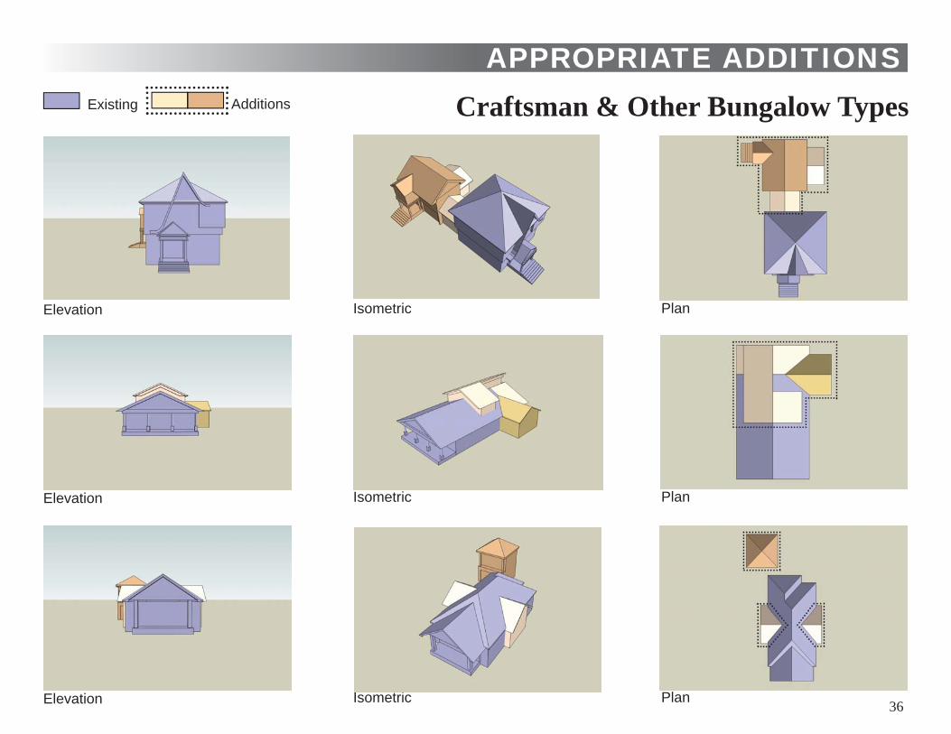
APPROPRIATE ADDITIONSCraftsman & Other Bungalow Types
36
Existing Additions
Elevation Isometric Plan
Elevation Isometric Plan
Elevation Isometric Plan
APPROPRIATE ADDITIONS
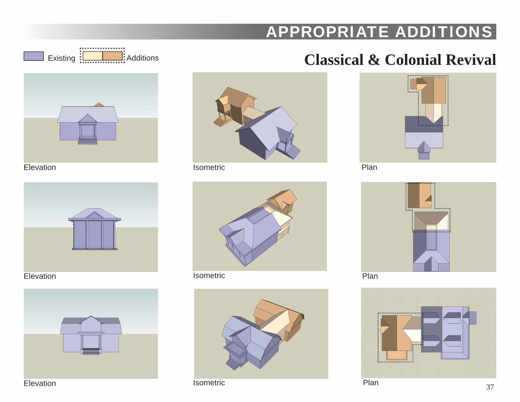
Classical & Colonial Revival
37
Existing Additions
Elevation Isometric Plan
Elevation Isometric Plan
Elevation Isometric Plan
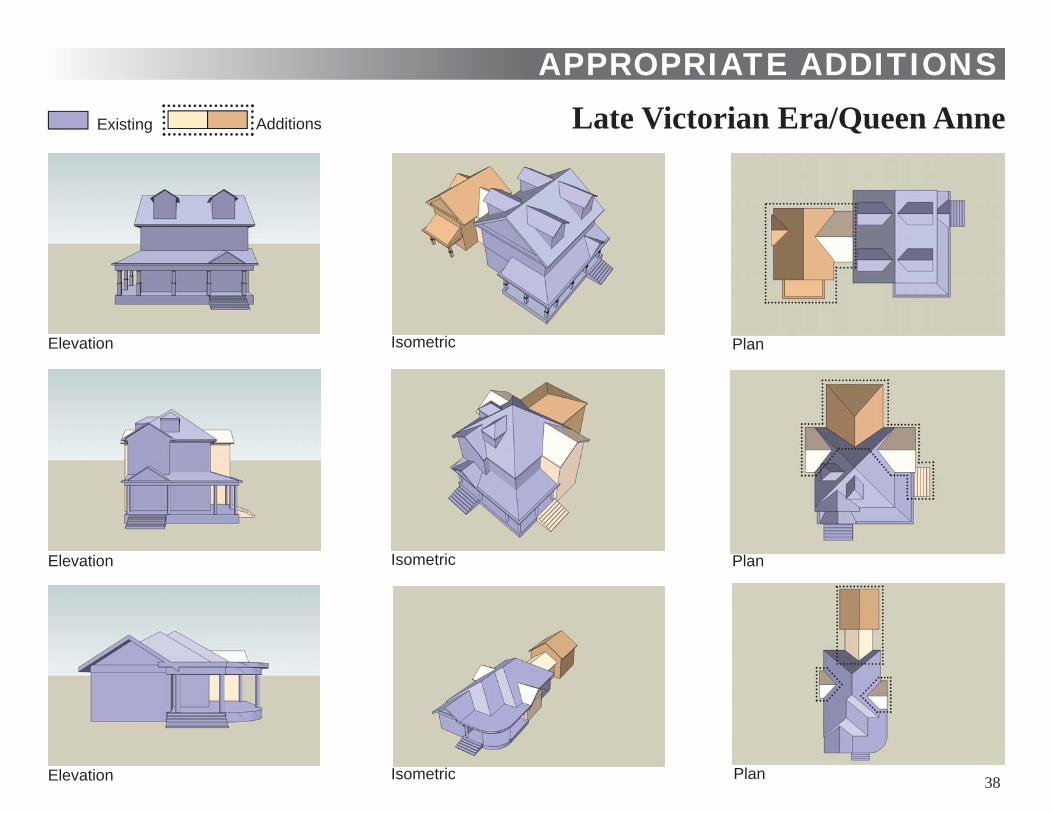
APPROPRIATE ADDITIONSLate Victorian Era/Queen Anne
38
Existing Additions
Elevation Isometric Plan
Elevation Isometric Plan
Elevation Isometric Plan
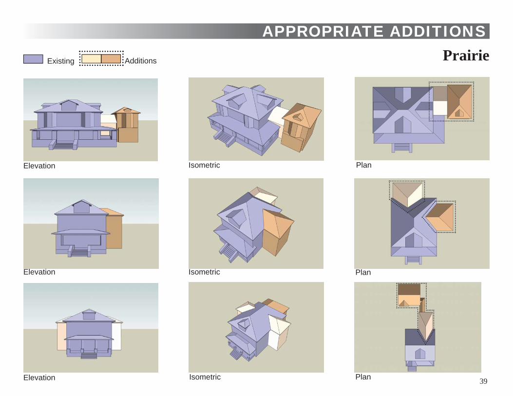
PrairieAPPROPRIATE ADDITIONS
39
Existing Additions
Elevation Isometric Plan
Elevation Isometric Plan
Elevation Isometric Plan
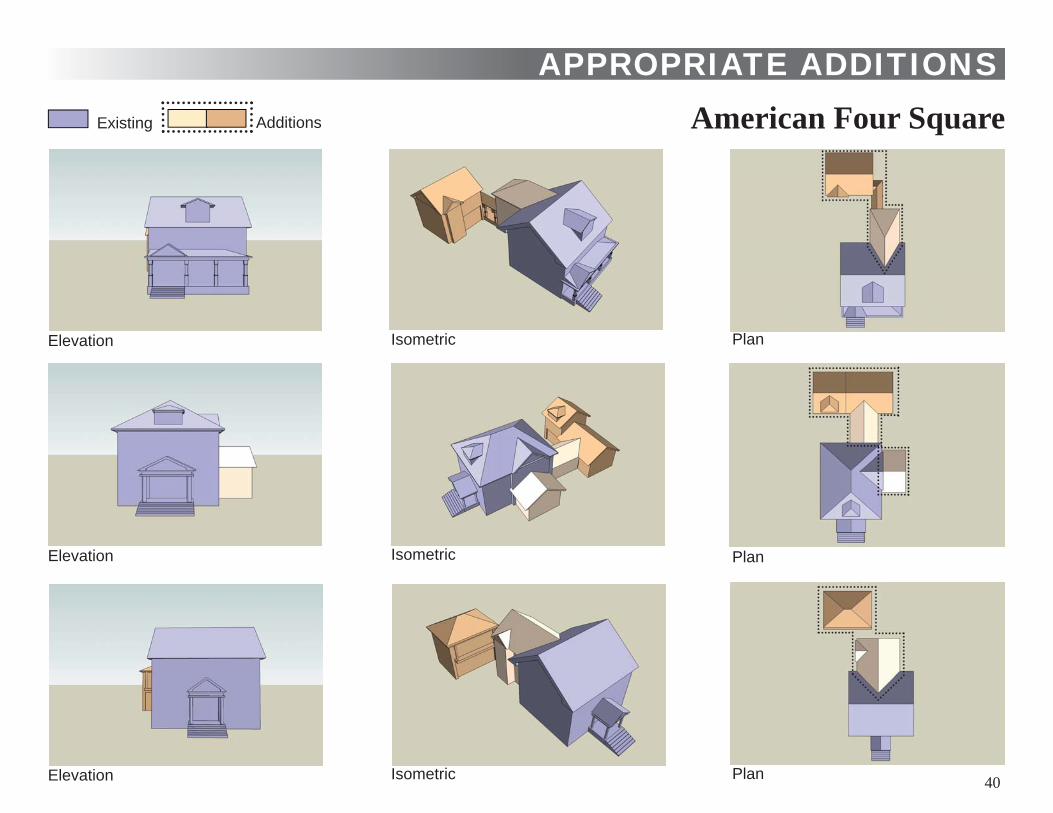
APPROPRIATE ADDITIONSAmerican Four Square
40
Existing Additions
Elevation Isometric Plan
Elevation Isometric Plan
Elevation Isometric Plan
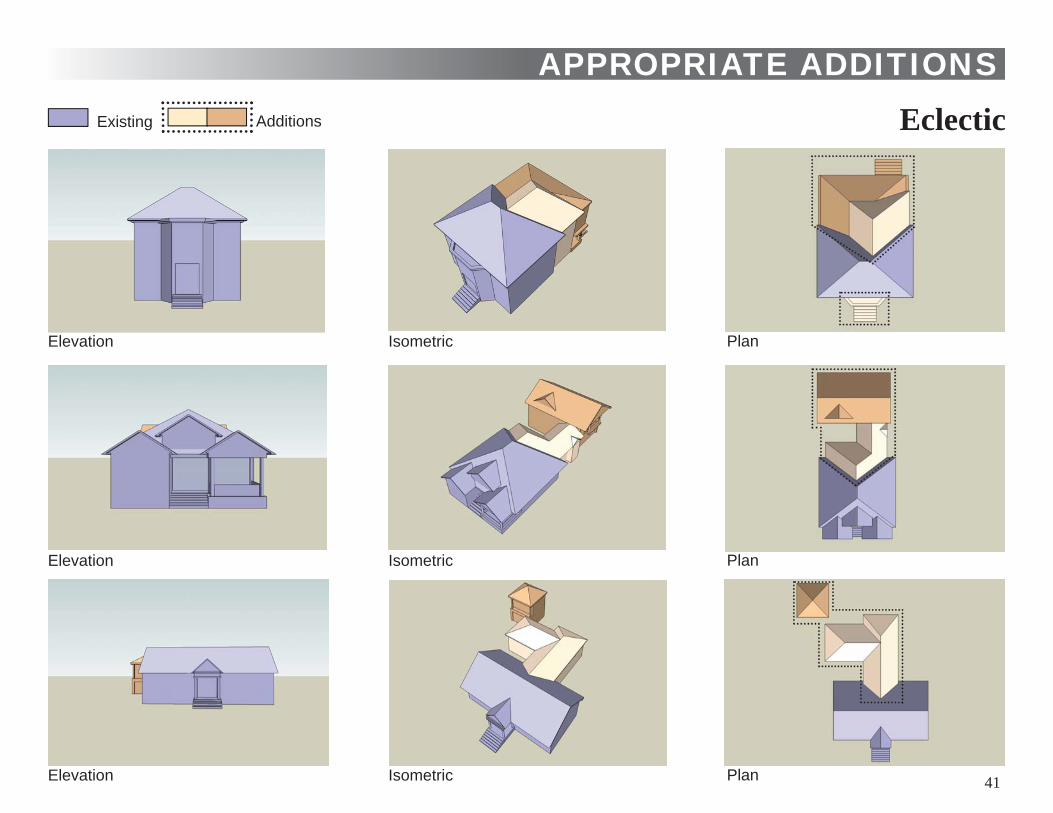
APPROPRIATE ADDITIONSEclectic
41
Existing Additions
Elevation Isometric Plan
Elevation Isometric Plan
Elevation Isometric Plan
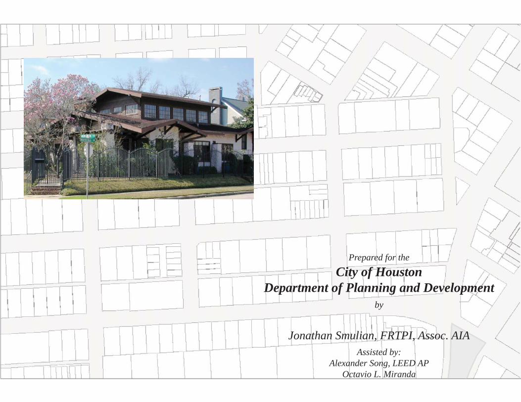
Prepared for the
City of HoustonDepartment of Planning and Development
by
Jonathan Smulian, FRTPI, Assoc. AIAAssisted by:
Alexander Song, LEED APOctavio L. Miranda