Embed Size (px)
Citation preview
HouseHolds PercePtions on Factors aFFecting resilience towards natural disasters in indonesia
Most areas in Indonesia are prone to natural disasters. Learning the lessons from the Aceh Tsu-nami in 2004, areas with high risks of natural disasters are in the process of preparing themselves for such an unexpected event, by increasing their resilience. The objective of this studyis to shed more lights on factors affecting the resilience from two sources namely, existing literatures and the application of disaster management in four disaster-prone areas in Indonesia -Padang, Sleman, Cilacap, and Palu. To enrich our analysis, we collect data from the field tocompare the prepared-ness and to get insights on people’s perceptions towards the factors of resilience in those areas.We employ IDI and FGD to identify the factors of resilience and the preparedness in the areas investi-gated. Thereafter, a preliminary survey is conducted to identify people’s perceptions towards the aspects of resilience in the areas. Results from the survey conducted to 800 households in Padang and Cilacap indicates that from the social aspect, community’s value cohesiveness is one of impor-tant factor affecting their resilience towards natural disaster. In addition, since almost 85 percent of their income was spending to fulfill their daily basic needs such as foods, clothing, and housing. Therefore, when disaster occurred, they heavily relied on the help of debt or selling some of their assets, as well as used cash in hand as emergency funds. In general, respondents in all sample cit-ies are able to re-start their economic activities as soon as two weeks after the event of disaster. In addition, the survey found that most of respondents were aware that the government has pro-grams to educate people on the disaster mitigation.
Keywords: Natural Disaster, Resilence, Preparedness, Indonesia
Abstract
indonesia is one of many countries with high risks of natural disas-ters, particularly earthquakes, due
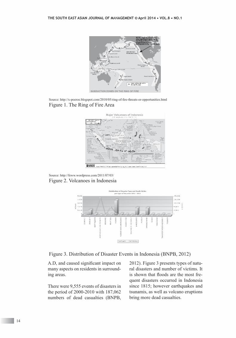
to the fact that this country is located between three active earth faults: the Pacific, Indo-Australian, and Eurasian (see Figure 1).
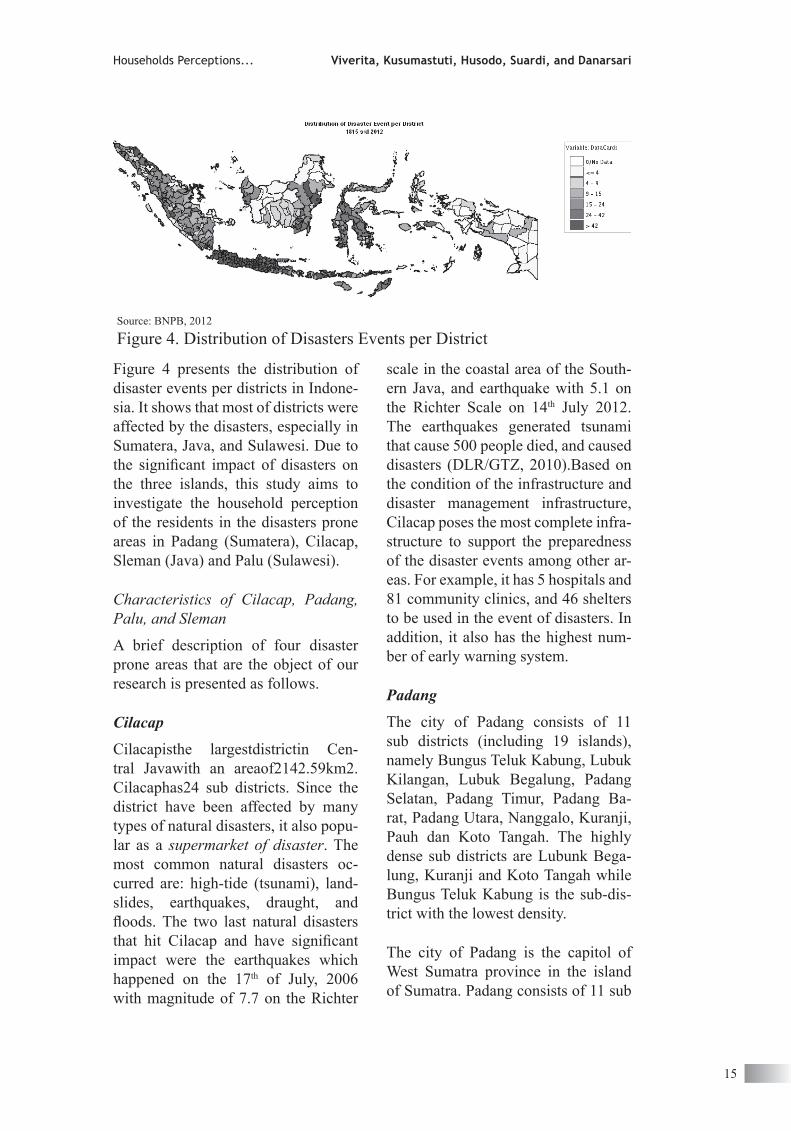
each plate in the fault moves with dif-ferent speed and directions. the co-movement of these three faults causes higher tectonic and volcanic activities in indonesia. as shown in Figure 2, most of areas are covered with active volcanoes which eruptions since 1900
13
ViveritaUniversitas Indonesia
Ratih Dyah KusumastutiUniversitas Indonesia
Zaafri Ananto HusodoUniversitas Indonesia
Lenny SuardiUniversitas Indonesia
Dwi Nastiti DanarsariUniversitas Indonesia
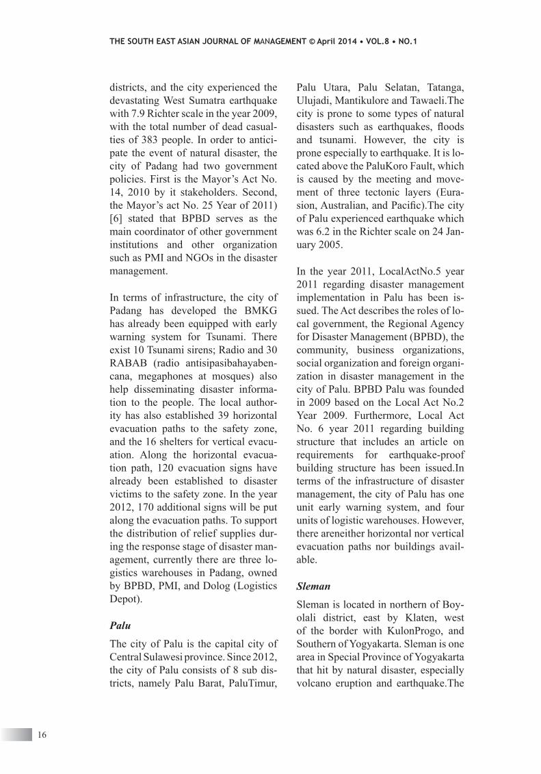
2012). Figure 3 presents types of natu-ral disasters and number of victims. it is shown that floods are the most fre-quent disasters occurred in indonesia since 1815; however earthquakes and tsunamis, as well as volcano eruptions bring more dead casualties.
A.D, and caused significant impact on many aspects on residents in surround-ing areas.
there were 9,555 events of disasters in the period of 2000-2010 with 187,062 numbers of dead casualties (BnPB,
THE SOUTH EAST ASIAN JOURNAL OF MANAGEMENT © April 2014 • VOL.8 • NO.1
14
Source: http://x-poeroe.blogspot.com/2010/05/ring-of-fire-threats-or-opportunities.html
Figure 1. the ring of Fire area
source: http://feww.wordpress.com/2011/07/03/
Figure 2. Volcanoes in indonesia
Figure 3. distribution of disaster events in indonesia (BnPB, 2012)
scale in the coastal area of the south-ern Java, and earthquake with 5.1 on the richter scale on 14th July 2012. the earthquakes generated tsunami that cause 500 people died, and caused disasters (dlr/gtZ, 2010).Based on the condition of the infrastructure and disaster management infrastructure, cilacap poses the most complete infra-structure to support the preparedness of the disaster events among other ar-eas. For example, it has 5 hospitals and 81 community clinics, and 46 shelters to be used in the event of disasters. in addition, it also has the highest num-ber of early warning system.
Padang
the city of Padang consists of 11 sub districts (including 19 islands), namely Bungus teluk Kabung, lubuk Kilangan, lubuk Begalung, Padang selatan, Padang timur, Padang Ba-rat, Padang utara, nanggalo, Kuranji, Pauh dan Koto tangah. the highly dense sub districts are lubunk Bega-lung, Kuranji and Koto tangah while Bungus teluk Kabung is the sub-dis-trict with the lowest density.
the city of Padang is the capitol of west sumatra province in the island of sumatra. Padang consists of 11 sub
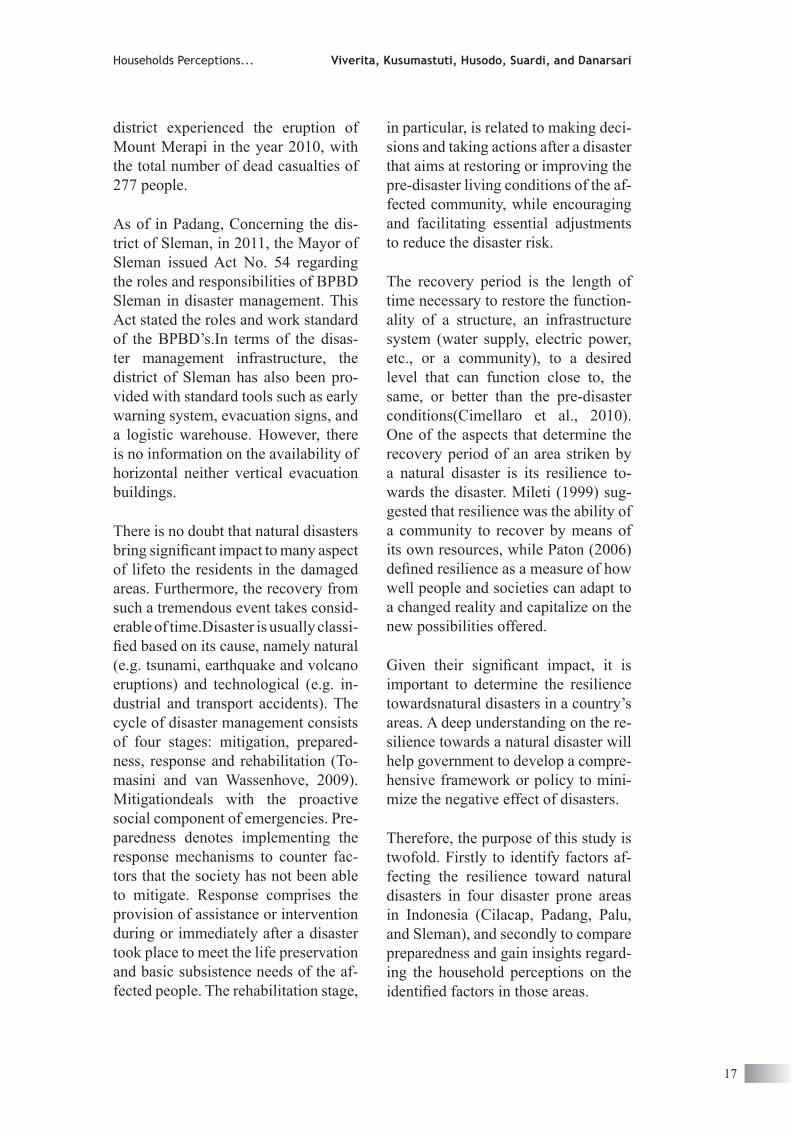
Figure 4 presents the distribution of disaster events per districts in indone-sia. it shows that most of districts were affected by the disasters, especially in sumatera, Java, and sulawesi. due to the significant impact of disasters on the three islands, this study aims to investigate the household perception of the residents in the disasters prone areas in Padang (sumatera), cilacap, sleman (Java) and Palu (sulawesi).
Characteristics of Cilacap, Padang, Palu, and Sleman
a brief description of four disaster prone areas that are the object of our research is presented as follows.
Cilacap
cilacapisthe largestdistrictin cen-tral Javawith an areaof2142.59km2. cilacaphas24 sub districts. since the district have been affected by many types of natural disasters, it also popu-lar as a supermarket of disaster. the most common natural disasters oc-curred are: high-tide (tsunami), land-slides, earthquakes, draught, and floods. The two last natural disasters that hit Cilacap and have significant impact were the earthquakes which happened on the 17th of July, 2006 with magnitude of 7.7 on the richter
Households Perceptions... Viverita, Kusumastuti, Husodo, Suardi, and Danarsari
15
source: BnPB, 2012
Figure 4. distribution of disasters events per district
Palu utara, Palu selatan, tatanga, ulujadi, Mantikulore and tawaeli.the city is prone to some types of natural disasters such as earthquakes, floods and tsunami. However, the city is prone especially to earthquake. it is lo-cated above the PaluKoro Fault, which is caused by the meeting and move-ment of three tectonic layers (eura-sion, Australian, and Pacific).The city of Palu experienced earthquake which was 6.2 in the richter scale on 24 Jan-uary 2005.
in the year 2011, localactno.5 year 2011 regarding disaster management implementation in Palu has been is-sued. the act describes the roles of lo-cal government, the regional agency for disaster Management (BPBd), the community, business organizations, social organization and foreign organi-zation in disaster management in the city of Palu. BPBd Palu was founded in 2009 based on the local act no.2 Year 2009. Furthermore, local act no. 6 year 2011 regarding building structure that includes an article on requirements for earthquake-proof building structure has been issued.in terms of the infrastructure of disaster management, the city of Palu has one unit early warning system, and four units of logistic warehouses. However, there areneither horizontal nor vertical evacuation paths nor buildings avail-able.
Sleman
sleman is located in northern of Boy-olali district, east by Klaten, west of the border with KulonProgo, and southern of Yogyakarta. sleman is one area in special Province of Yogyakarta that hit by natural disaster, especially volcano eruption and earthquake.the
districts, and the city experienced the devastating west sumatra earthquake with 7.9 richter scale in the year 2009, with the total number of dead casual-ties of 383 people. in order to antici-pate the event of natural disaster, the city of Padang had two government policies. First is the Mayor’s act no. 14, 2010 by it stakeholders. second, the Mayor’s act no. 25 Year of 2011) [6] stated that BPBd serves as the main coordinator of other government institutions and other organization such as PMi and ngos in the disaster management.
in terms of infrastructure, the city of Padang has developed the BMKg has already been equipped with early warning system for tsunami. there exist 10 tsunami sirens; radio and 30 raBaB (radio antisipasibahayaben-cana, megaphones at mosques) also help disseminating disaster informa-tion to the people. the local author-ity has also established 39 horizontal evacuation paths to the safety zone, and the 16 shelters for vertical evacu-ation. along the horizontal evacua-tion path, 120 evacuation signs have already been established to disaster victims to the safety zone. in the year 2012, 170 additional signs will be put along the evacuation paths. to support the distribution of relief supplies dur-ing the response stage of disaster man-agement, currently there are three lo-gistics warehouses in Padang, owned by BPBd, PMi, and dolog (logistics depot).
Palu
the city of Palu is the capital city of central sulawesi province. since 2012, the city of Palu consists of 8 sub dis-tricts, namely Palu Barat, Palutimur,
THE SOUTH EAST ASIAN JOURNAL OF MANAGEMENT © April 2014 • VOL.8 • NO.1
16
in particular, is related to making deci-sions and taking actions after a disaster that aims at restoring or improving the pre-disaster living conditions of the af-fected community, while encouraging and facilitating essential adjustments to reduce the disaster risk.
the recovery period is the length of time necessary to restore the function-ality of a structure, an infrastructure system (water supply, electric power, etc., or a community), to a desired level that can function close to, the same, or better than the pre-disaster conditions(cimellaro et al., 2010). one of the aspects that determine the recovery period of an area striken by a natural disaster is its resilience to-wards the disaster. Mileti (1999) sug-gested that resilience was the ability of a community to recover by means of its own resources, while Paton (2006) defined resilience as a measure of how well people and societies can adapt to a changed reality and capitalize on the new possibilities offered.
Given their significant impact, it is important to determine the resilience towardsnatural disasters in a country’s areas. a deep understanding on the re-silience towards a natural disaster will help government to develop a compre-hensive framework or policy to mini-mize the negative effect of disasters.
therefore, the purpose of this study is twofold. Firstly to identify factors af-fecting the resilience toward natural disasters in four disaster prone areas in indonesia (cilacap, Padang, Palu, and sleman), and secondly to compare preparedness and gain insights regard-ing the household perceptions on the identified factors in those areas.
district experienced the eruption of Mount Merapi in the year 2010, with the total number of dead casualties of 277 people.
as of in Padang, concerning the dis-trict of sleman, in 2011, the Mayor of sleman issued act no. 54 regarding the roles and responsibilities of BPBd sleman in disaster management. this act stated the roles and work standard of the BPBd’s.in terms of the disas-ter management infrastructure, the district of sleman has also been pro-vided with standard tools such as early warning system, evacuation signs, and a logistic warehouse. However, there is no information on the availability of horizontal neither vertical evacuation buildings.
there is no doubt that natural disasters bring significant impact to many aspect of lifeto the residents in the damaged areas. Furthermore, the recovery from such a tremendous event takes consid-erable of time.disaster is usually classi-fied based on its cause, namely natural (e.g. tsunami, earthquake and volcano eruptions) and technological (e.g. in-dustrial and transport accidents). the cycle of disaster management consists of four stages: mitigation, prepared-ness, response and rehabilitation (to-masini and van wassenhove, 2009).Mitigationdeals with the proactive social component of emergencies. Pre-paredness denotes implementing the response mechanisms to counter fac-tors that the society has not been able to mitigate. response comprises the provision of assistance or intervention during or immediately after a disaster took place to meet the life preservation and basic subsistence needs of the af-fected people. the rehabilitation stage,
Households Perceptions... Viverita, Kusumastuti, Husodo, Suardi, and Danarsari
17
capital and economic development) that can be fostered to enhance the ability to recover from disasters, Ka-han et al. (2009) assumed that resil-ience was an outcome measure related to critical infrastructure.
according to Bruneau et al. (2003) resilience consist of four inter-related dimensions, namely technical, orga-nizational, social, and economic. the technical and organizational dimen-sions are related to the performance and resilience of critical systems such as utilities and hospital, whereas the social and economic dimensions are most pertinent to the performance and resilience of the community as a whole (chang and shinozuka, 2004).
simpson (2006) argued that the indi-cators of resilience are community as-sets, social capital, infrastructure/sys-tem quality, planning, social services, and population demographics.
Razafindrabe et al. (2009)found that there are five dimensions of resil-ience towards disaster (in this case is climate disaster). they are physical (e.g. electricity, water supply, sanita-tion, etc.), social (health status, edu-cation and awareness, social capital), economic (e.g. income, employment, households’ assets, etc.), institutional (e.g. internal institution and develop-ment plan, effectiveness of internal institutions, etc.), and natural (hazard frequency and hazard density).
Paton and Johnston (2001), on the other hand, show that community re-silience towards disaster required safe-guarding the physical integrity (e.g. building codes), ensuring the continu-ity of economic, business and adminis-
the rest of this paper is organized as follows: section 2 provides relevant literature pertaining to resilience and preparedness towards natural disas-ters. section3 explains the research methodology. section 4 describes the research findungs. Lastly, conclusion of the findings and the implications are presented in section 5.
Literature review
the united nations international strat-egy for disaster reduction (unisdr) defines resilience as:
“the ability of a system, communi-ty or society exposed to hazards to resist, absorb, accommodate to and recover from the effects of a hazard in a timely and efficient manner, including through the preservation and restoration of its essential basic structures and functions.”
resilience means the ability to bounce back from a shock, and it is determined by the degree to which the community has the required resources and is ca-pable of organizing itself prior to and during the times of need(unisdr, 2012).
disaster resilience along with eco-nomic vitality, environmental quality, social and inter-generational equity, quality of life, and participatory pro-cess are the six principles of sustain-ability (natural hazard centre, 2006). according to Birkmann (2006), mea-suring vulnerability is increasingly be-ing seen as a key step toward effective risk reduction and the promotion of a culture toward disaster resilience.
norris et al. (2008) viewed resilience as adaptive capacities (such as social
THE SOUTH EAST ASIAN JOURNAL OF MANAGEMENT © April 2014 • VOL.8 • NO.1
18
as well as strengthening people knowledge(ecHo, 2012).
in addition, sutton and tierney (2006) suggest that preparedness is a critical factor for households, business, and the community. For example, house-holds need to understand the vulnera-bility and disaster preparedness to im-prove their life safety, to protect their property protection, and to survive from hazardous events. Furthermore, business sector as the locomotive of the economy may directly and/or in-directly involved in crisis-relevant ac-tivities at the time of disasters, in term of disaster response through contracts and mutual aid agreements. Moreover, the community represented by the lo-cal political jurisdiction (municipal government, city government, county government) is responsible for emer-gency preparedness, emergency alert and notification, as well as emergency response and recovery (sorensen and rogers, 1988).
therefore, there are at least three fac-tors that affect preparedness towards disaster, i.e: households, organiza-tions and communities (sorenson and rogers, 1988). takao et al. (2004) indicated different factors that affect people preparedness for natural disas-ter in the case of the Tokai floods in Japan. they suggested three important factors: ownership of home, fear of flood, and the amount of damage from the previous event will affect people’s preparedness towards natural disasters
research Method
this study employed a survey with 50 sample households in each of the four disaster-prone areas in indonesia, with total sample of 200 households.
trative (including emergency manage-ment and social institutions), and also ensuring that the community members have the resources, capacities and ca-pabilities necessary to utilize the phys-ical and economic resources to mini-mize disruptions.
lastly, indicators of community re-silience includes several dimensions, such as ecological (e.g. erosion rates and biodiversity), social (e.g. demo-graphics, and social networks), eco-nomic (e.g. employment and value of property), institutional (e.g. haz-ard mitigation plan and emergency response plans), infrastructure (e.g. transportation network and residential housing stock and age) and communi-ty competence (e.g. local understand-ing of risk and health and wellness) (cutter et al. (2008) and cutter et al. (2010)).
Quantarelli (1981) and simpson (2006) states that resilience is a func-tion of community preparedness and vulnerability (i.e. the community’s exposure to the disaster).there are some definitions of the disaster pre-paredness. For example, the european Commission Humanitarian Aid Office (ECHO) defined preparedness as:
The organizational activities which ensure that the systems, procedures and resources required to confront a natural disaster are available in order to provide timely assistance to those affected, using existing mechanisms wherever possible.
these activities may include build-ing the stakeholders’ awareness, es-tablishing disaster evacuation plans, set the early warning mechanisms,
Households Perceptions... Viverita, Kusumastuti, Husodo, Suardi, and Danarsari
19
THE SOUTH EAST ASIAN JOURNAL OF MANAGEMENT © April 2014 • VOL.8 • NO.1
20
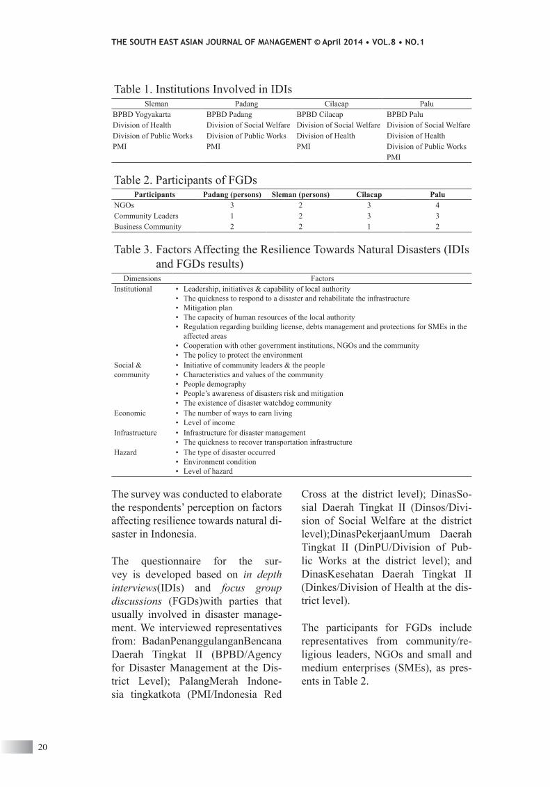
cross at the district level); dinasso-sial daerah tingkat ii (dinsos/divi-sion of social welfare at the district level);dinasPekerjaanumum daerah tingkat ii (dinPu/division of Pub-lic works at the district level); and dinasKesehatan daerah tingkat ii (dinkes/division of Health at the dis-trict level).
the participants for Fgds include representatives from community/re-ligious leaders, ngos and small and medium enterprises (sMes), as pres-ents in table 2.
the survey was conducted to elaborate the respondents’ perception on factors affecting resilience towards natural di-saster in indonesia.
the questionnaire for the sur-vey is developed based on in depth interviews(idis) and focus group discussions (Fgds)with parties that usually involved in disaster manage-ment. we interviewed representatives from: BadanPenanggulanganBencana daerah tingkat ii (BPBd/agency for disaster Management at the dis-trict level); PalangMerah indone-sia tingkatkota (PMi/indonesia red
table 1. institutions involved in idissleman Padang cilacap Palu
BPBd Yogyakarta BPBd Padang BPBd cilacap BPBd Paludivision of Health division of social welfare division of social welfare division of social welfaredivision of Public works division of Public works division of Health division of HealthPMi PMi PMi division of Public works
PMi
table 2. Participants of FgdsParticipants Padang (persons) sleman (persons) cilacap Palu
ngos 3 2 3 4community leaders 1 2 3 3Business community 2 2 1 2
table 3. Factors affecting the resilience towards natural disasters (idis and Fgds results)
dimensions Factorsinstitutional • leadership, initiatives & capability of local authority
• the quickness to respond to a disaster and rehabilitate the infrastructure• Mitigation plan• the capacity of human resources of the local authority• regulation regarding building license, debts management and protections for sMes in the
affected areas• cooperation with other government institutions, ngos and the community• the policy to protect the environment
social & community
• initiative of community leaders & the people• characteristics and values of the community• People demography• People’s awareness of disasters risk and mitigation• the existence of disaster watchdog community
economic • the number of ways to earn living• level of income
infrastructure • infrastructure for disaster management• the quickness to recover transportation infrastructure
Hazard • the type of disaster occurred• environment condition• level of hazard
Households Perceptions... Viverita, Kusumastuti, Husodo, Suardi, and Danarsari
21
ience towards natural disasters. they also agree with the important of di-saster watchdog community and the existence of community leaders as im-portant social factors. Furthermore, in terms of economics, infrastructure and hazard dimensions, the interviewees and Fgd’s participants share a com-mon opinion on the important of fam-ily income, infrastructure for disaster management, and types of disaster as well as the level of hazard.
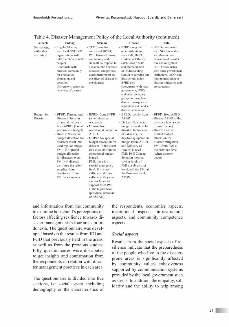
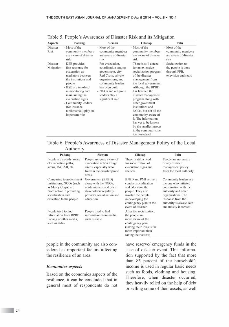
Based on findings from Table 4 to Ta-ble 6 it can be concluded that in terms of policy, the sample areas already had formal policies in mitigating nat-ural disasters. each of local govern-ment already established such local authority acts that stated roles and responsibilities of agency for disas-ter Management at the district level (BPBd). Furthermore, in terms of in-frastructure, all areas equipped with logistic warehouses, sirens and shel-ters in every villages. all areas have provided both vertical and horizontal evacuation paths, whilst sleman only provides horizontal paths. to educate communities on how to deal with di-sasters when they occurs, BPBd along with volunteers from informal and non-government organizations con-ducted trainings and evacuation simu-lation regularly in every village. in addition, cilacap is found to be more prepared than the other area in terms of financial readiness.Finally, people awareness of the disaster risk largely built by the help of KsB, a semi-for-mal organizations.
b. households’ perceptions on fac-tors of resilience
This section reports finding from the survey held to collect primary data
Findings and discussion
Based on idis and Fgd held to those respective institutions, we disseminate a list of questions to gather informa-tion about the perception of house-holds living in the disaster-prone areas in four cities. the results are present-ing in the following sections.
a. Factors affecting resilience towards Natural disasters
Based on the literature review, the di-mensions of resilience are social and community, economic, institutional, infrastructure, and hazard. they can be further classified into the prepared-ness and vulnerability aspects of the area. For instance, hazard frequency is related to vulnerability, hazard miti-gation plan is related to preparedness, while community competence can ei-ther related to preparedness or vulner-ability.
we asked the idis interviewees and the Fgds participants their perspec-tives regarding factors determining the resilience of the areas that they were living in, based on their past experi-encewitnessing the recovery process from the 2009 west sumatra earth-quakes and the 2010 Mount Merapi eruptions, 2006 southern Java earth-quake, and the 2005 Palu earthquake.the results of idis and Fgds in the abovementioned areas are presented in the table 3.
as presents in table 3, the idis inter-viewees and the Fgds participants in four areasagree that leadership, time to respond and rehabilitate the in-frastructure, mitigation plan as well as regulation is among the important factors of institutional aspect of resil-

THE SOUTH EAST ASIAN JOURNAL OF MANAGEMENT © April 2014 • VOL.8 • NO.1
22
table 4. disaster Management Policy of the local authorityaspects Padang sleman cilacap Palu
Policy - Mayor’s act no. 14 Year 2010 (soP for early warning system for tsunami)
- Mayor’s act no. 25, 2011 (soP for disaster management, states the roles of all stakeholders of Padang)
- Mayor’s act no. 54, 2011 (states the role and responsibility of the BPBd)
- local act no. 22 year 2008 (states the role and responsibility of the BPBd).
- local act no. 11 year 2009 (states the role of local government in handling social welfare of the victims, as well as determined the related policies needed in disaster mitigation)
- local actno.5 year 2011 (soP for disaster management, states the roles of all stakeholders of Palu)
- local act no. 6 year 2011 (regarding building structure that includes an article on requirements for earthquake-proof building structure)
infrastructure - the availability of vertical and horizontal evacuation paths
- 3 logistics warehouses- ews: 10 tsunami
sirens,- 30 raBaB (mosque’s
speaker)- 39 horizontal
evacuation paths- 16 shelters for vertical
evacuation- 120 evacuation signs
(by the year of 2012)
- Horizontal evacuation path
- 1 logistics warehouse- shelters in every
village- sirens for evacuation
is available- evacuation signs are
available
- the availability vertical and horizontal evacuation path
- 1 logistics warehouse- ews: 7 units of
tsunami sirens- 100 evacuation signs
(by the year of 2011)- 46 shelter for vertical
evacuation
- Vertical and horizontal evacuation paths are not available
- 4 logistics warehouses- ews: 1 unit of
tsunami siren- the evacuation routes
have been stated in local act no. 16 Year 2011, however evacuations signs are not available yet
- shelters have not been yet determined, however, recommendation of safety zones (for temporary shelters) for flood, landslide, earthquake and tsunami has been submitted to BnPB
education - BPBd, dinsos, PMi, non governmental organizations (ngos) are involved in educating the local people regarding the disaster risk and its mitigation
- 17 evacuation simulations and socializations
- training for 10 representatives from all urban village in Padang
- BPPd conducts training and simulation as anticipation of disaster in every village in Yogakarta since 2011
- dinsos, dinkes, PMi, and ngos also conduct training and socialization for the people
- the disaster community (community groups for disaster mitigation) is involved in developing the contingency plan
- BPBd in collaboration with several institutionssocializes and educates community representatives through training for trainers (tot). the trainees are expected to replicate the training to the people, so that community itself is able to develop the contingency plan
- BPBd in collaboration with ngo conducts socialization of earthquake-proof building structure to the people
- PMi also conduct education/socialization to the people (community/religous leaders, students, company)
- BPBd has formed disaster Forum (Forum PeduliBencana, FPB) in the sub districts and urban villages that are prone to disasters.
- socializations of preparedness to the heads of sub districts and urban villages have been conducted by BPBd in every sub district
- socialization to the people have been carried out through FPB and via television (tVri) and radio (rri)
Households Perceptions... Viverita, Kusumastuti, Husodo, Suardi, and Danarsari
23
the respondents, economics aspects, institutional aspects, infrastructural aspects, and community competence aspects.
Social aspects
results from the social aspects of re-silience indicate that the preparedness of the people who live in the disaster-prone areas is significantly affected by community values cohesiveness supported by communication systems provided by the local government such as sirens. in addition, the empathy, sol-idarity and the ability to help among
and information from the community to examine household’s perceptions on factors affecting resilience towards di-saster management in four areas in in-donesia. the questionnaire was devel-oped based on the results from idi and Fgd that previously held in the areas, as well as from the previous studies. Fifty questionnaires were distributed to get insights and confirmation from the respondents in relation with disas-ter management practices in each area.
The questionnaire is divided into five sections, i.e: social aspect, including demography or the characteristics of
table 4. disaster Management Policy of the local authority (continued)aspects Padang sleman cilacap Palu
networking with other institution
- regular Meeting with local ngos (36 organizations with total members of 6000 people)
- coordinate with business community for evacuation simulation and donation
- university students in the event of disaster
- trc (team that consists of BPBd, PMi, dinkes, dinsos, community, and student) to respond to a disaster the first time it occurs, and provide assessment report on the effect of disaster in the hit areas
- BPBd along with other institutions such PMi, dinPu, dinkes, and dinsos, established a soP and Memorandum of understanding (Mou) in carrying out disaster mitigation
- BPBd also coordinates with local government, ngos and other voluntary groups to formulate disaster management regulation and conduct disaster simulation
- BPBd coordinates with ngo toconduct socialization and education of disaster risk and mitigation
- BPBd coordinates with other government institutions, ngo, and foreign institution in disaster mitigation and preparedness
Budget for disaster
- BPBd, dinkes, and dinsos (division of social welfare) from aPBd (local government budget)
- dinPu: no special budget allocation for disasters event, but used regular budget
- PMi : no special budget allocation for disasters event. PMi will directly distribute the relief supplies from donators or from PMi headquarters
- BPBd: from BnPB (when disaster occurred)
- dinsos: from operational budget in aPBd
- dinPu: no special budget allocation for disaster. in the event of a disaster, routine operational budget is used
- PMi: there is a special emergency fund. if it is not sufficient, if it not sufficient, they can ask for financial support from PMi at the higher level (province, national or asean).
- BPBd: mainly from aPBd
- dinkes: no special budget allocation for disaster. in theevent of a disaster, the day-to-day operation budget (from aPBd and Ministry of Health) is used
- PMi: PMi cilacap, donation months, saving funds of PMi at sub-district level, and the PMi at the Province level, aPBn
- BPBd: from aPBd- dinsos: aPBd at the
province level (when disaster occur)
- dinPu: there is limited budget allocation for disaster mitigation
- PMi: from PMi at the province level (when disaster occur)
THE SOUTH EAST ASIAN JOURNAL OF MANAGEMENT © April 2014 • VOL.8 • NO.1
24
have reserve/ emergency funds in the case of disaster event. this informa-tion supported by the fact that more than 85 percent of the household’s income is used in regular basic needs such as foods, clothing and housing. therefore, when disaster occurred, they heavily relied on the help of debt or selling some of their assets, as well
people in the community are also con-sidered as important factors affecting the resilience of an area.
Economics aspects
Based on the economics aspects of the resilience, it can be concluded that in general most of respondents do not
table 5. People’s awareness of disaster risk and its Mitigationaspects Padang sleman cilacap Paludisaster risk
- Most of the community members are aware of disaster risk
- Most of the community members are aware of disaster risk
- Most of the community members are aware of disaster risk.
- Most of the community members are aware of disaster risk
disaster Mitigation
- KsB provides first response for evacuation as mediators between the institutions and people
- KsB are involved in monitoring and maintaining the evacuation signs
- community leaders (for instance ninikmamak) play an important role
- For evacuation, coordination among government, city red cross, private organizations, and community leaders has been built
- ngos and religious leaders play a significant role
- there is still a need for an extensive socialization program of the disaster management from the local government. although the BPBd has lauched the disaster management program along with other govenment institutions and ngos, but not all the community aware of it. the information has yet to be known by the smallest group in the community, i.e: the household
- socialization to the people is done through FPB, television and radio
table 6. People’s awareness of disaster Management Policy of the local authority
Padang sleman cilacap PaluPeople are already aware of evacuation paths, sirens, raBaB, etc
People are quite aware of evacuation action trough sirens, especially who lived in the disaster prone areas
there is still a need for socialization of evacuation signs and shelters
People are not aware of any disaster management policy from the local authority
comparing to government institutions, ngos (such as Mercy corps) are more active in providing socialization and education to the people
government (BPBd) along with the ngos, academicians, and other stakeholders regularly provides socialization and education
BPBd and PMi actively conduct socialization and education the people. they also involve the people in developing the contingency plan in the event of disaster
community leaders are the one who initiated coordination with the authority and other organizations. the response from the authority is always late and mostly incorrect.
People tried to find information from BPBd Padang or other media, such as radio
People tried to find information from media, such as radio
after the socialization, the people are more aware of the contingency plan (saving their lives is far more important than saving their assets)
Households Perceptions... Viverita, Kusumastuti, Husodo, Suardi, and Danarsari
25
respondents agreed that there were no communication barriers during and af-ter the disaster event.
conclusionthe purpose is this study is twofold.Firstly to identify factors affecting the resilience toward natural disasters in four disaster prone areas in indonesia (cilacap, Padang, Palu, and sleman), and secondly to compare preparedness and gain insights regarding the house-hold perceptions on the identified fac-tors in those areas.
this study applies qualitative research methods of in dept interview (idi) and focus group discussion (Fgd) to col-lect data and information regarding the perception of households in four disaster-prone areas in indonesia, i.e: cilacap, Padang, Palu, and sleman.
Findingsfrom the survey indicate that in terms of social aspects of resilience, the preparedness of the people who live in the disaster-prone areas is sig-nificantly affected by community val-ues cohesiveness supported by com-munication systems provided by the local government as well as the empa-thy, solidarity and the ability to help among the people. regarding eco-nomics aspect of the resilience, it can be concluded that in general most of respondents do not have reserve/emer-gency funds and they heavily relied on the help of debt or selling some of their assets to recover after the disaster event. in addition, in terms of institu-tional aspect of resilience, we find that most of respondents agree that govern-ment has programs to educate people, however the participation the average frequency of attending the program only once in the last two year. the lo-
as used cash in hand as emergency funds. This condition is also reflected by the recovery time after the event. in general, respondents in all sample cit-ies are able to re-start their economic activities as soon as two weeks after the event of disaster.
Institutional aspects
results from the survey found that most of respondents were aware that the government has programs to edu-cate people on the disaster mitigation. the information delivered in infor-mation program is different among the four observed cities based on the types of previous disaster events. the most common used tools as the early warning system in the four cities are loudspeaker placed scattered in the ar-eas. the survey indicates that the most common places used as temporary shelter are public fields. In addition to those places, open fields and religious center (or place for worship) is also used. other evacuation shelters that used are the government offices, main roads, neighbors’ houses, other fam-ily houses, and hospitals. it is shown that on average the distance to the tem-porary shelters is more than one KM, except for Palu. in addition, people in Yogyakarta are relocated far from their houses since the types of disaster oc-curred mostly in the form of volcano eruptions.
Infrastructure aspects
in general, in terms of infrastructure, each of the four cities has different level of preparedness towards natural disasters. However, they share com-mon perception on the infrastructure of the telecommunication system. it reveals that more than 80 percent of
THE SOUTH EAST ASIAN JOURNAL OF MANAGEMENT © April 2014 • VOL.8 • NO.1
26
than the other area in terms of finan-cial readiness, which is in accordance with preliminary survey result stating that in all resilience aspects, cilacap is relatively more prepared compared to other three cities.
Finally, people awareness of the di-saster risk largely built by the help of KsB, a semi-formal organization both in Padang and sleman. this organiza-tion includes community leaders, the youths, and religious leaders
cal governments in four cities have also provided areas, such as schools, open fields and or religious centers as temporary shelters in to relocate peo-ple in the event of disaster. regarding infrastructure aspect of resilience, each city has different level of preparedness towards natural disasters, but major-ity of respondents agree that there is no communication barrier during and post disaster events. Based on the idis and Fgds and preliminary sur-vey results, cilacap is more prepared
ReferencesBnPB (2012). data dan informasi Bencana indonesia (indonesian disaster data
and information), obtained through: http://dibi.bnpb.go.id/desinventar/dash-board.jsp & http://dibi.bnpb.go.id/desinventar/dashboard.jsp, [accessed on 1 May 2012].
cimellaro, g. P., reinhorn, a. M., & Bruneau, M. (2010). Framework for analyti-cal quantification of disaster resilience. Engineering Structures, 32(11), 3639-3649.
cutter, s. l., Barnes, l., Berry, M., Burton, c., evans, e., tate, e., & webb, J. (2008). a place-based model for understanding community resilience to natu-ral disasters. Global environmental change, 18(4), 598-606.
Birkmann, J. (2006). Measuring vulnerability to promote disaster-resilient societ-ies: Conceptual frameworks and definitions, In J. Birkmann (Ed.), Measuring vulnerability to natural hazard: Toward disaster resilient societies, united na-tions university, 9-54.
Mileti, d. s. (1999). Disasters by design: A reassessment of natural hazards in the United States. national academies Press.
Paton, d., & Johnston, d. (2001). disasters and communities: vulnerability, resil-ience and preparedness. Disaster Prevention and Management, 10(4), 270-277.
d.Paton, d and Bishop, B in Paton and Johnston,(2001). Disasters and Com-munities: Promoting Psychological Aspects of Disaster: Impact, Coping, and Intervention. dunmore Press, Permaston north.
Paton, d. (2006). disaster resilience: Building capacity to co-exist with natural hazards and their consequences, in Paton, D., & Johnston, D. M. (Eds.). Disaster resilience: an integrated approach. Charles C. Thomas Publisher.
d.M. simpson, (2006). indicator issues and proposed framework for a disaster Preparedness index (dPi),center for Hazard research and Policy develop-ment, university of louisville
(dlr/gtZ, (2010).DokumentasiTeknis. PetaBahaya Tsunami untukKabupaten-Cilacap., obtained
Households Perceptions... Viverita, Kusumastuti, Husodo, Suardi, and Danarsari
27
through: http://www.gitews.org/tsunami-kit/id/e1/sumber_lainnya/peta_bahaya/jawa_cilacap_gitews/dokumentasi%20teknis%20Pemetaan%20Baha-ya%20tsunami%20cilacap.pdf. [accessed on 8october, 2012].
F.H. norris, s.P. stevens, B. Pfefferbaum, K.F.wyche, r.l.Pfefferbaum, (2008). community resilience as a Metaphor, theory, set of capacities,and strategy for disaster readiness, American Journalof Community Psychology, 41, 127–150.
g.P. cimellaro, a. M. reinhorn, M. Bruneauc, (2010). Framework for analytical quantification of disaster resilience, Engineering Structures, 32, 3639–3649
J.H, Kahan, a.c. allen, J.K. george, (2009). an operationalframework for resil-ience.Journal of Homeland Security and Emergency Management, 6, 1.
Mileti, dennis.(1999). A Reassessment of Natural Hazards in the United States.a Joseph Henry Press book. isBn: 0-309-51849-0,37pages. http://www.nap.edu/catalog/5782.html.
M. Bruneau, s.e. chang, r.t. eguchi, g.c. lee, t.d. oírourke, a.M. rein-horn, M. shinozuka, K. tierney, w.a. wallace, d.a. von winterfeldt, (2003). Framework to Quantitatively assess and enhance the seismic resilience of communities, Earthquake Spectra,19, 4, 733-752.
natural Hazard center,(2006). university of colorado. Holistic disaster recovery: ideas for building local sustainability after a natural disaster, Public entity risk institute.
Quarantelli, R. (1981) .What is a disaster? An agent specific or an all disaster spectrum approach to socio behavioral aspects of earthquakes?Proceedings of The Third International Conference: The Social and Economics Aspects of Earthquakes and Planning to Mitigate Their Impacts, Bled, Yugoslavia, 29 June-2 July 1981, pp. 453-478.
r. tomasini, l. van wassenhove. Humanitarian Logistics, (2009), Palgrave Mac-Millan, new York.
takao, Kenji, Motoyoshi,t, sato, t, Fukuzondo,t, seo, t, and ikeda, s.(2004). Factors determining residents’ preparedness for floods in modern megalopo-lises: the case of the Tokai flood disaster in Japan. Journal of Risk Research, 7, issue 7-8:2004: 775-787.
unisdr.terminology, obtained through the internet: http://www.unisdr.org/we/inform/terminology, [accessed on 30 June 2012].
s.e. chang, M. shinozuka, (2003). Measuring improvements in the disaster resil-ience of communities, earthquake spectra, 20, 3, 739-755.
B.H.N. Razafindrabe, G.A. Parvin, A. Surjan, Y. Takeuchi, R. Shaw, (2009). cli-mate disaster resilience: Focus on coastal urban cities in asia, asian Journal of environment and disaster Management 1, 101-116.
Pusdalops Prov. sumbar. total korbantewaspascagempa 7,9 sr di sumbarseban-yak 1.195 orang (the total dead casualties of 7.9 sr in west sumatra is 1,195 people), obtained through the internet: http://www.sumbarprov.go.id/detail.php?id=347[accessed on 30 June 2012]
s.l. cutter, l. Barnes, M. Berry, c. Burton, e. evans, e. tate, J. webb, 2008). a place-based model for understanding community resilience to natural disasters, Global Environmental Change, 18, 598–606.
THE SOUTH EAST ASIAN JOURNAL OF MANAGEMENT © April 2014 • VOL.8 • NO.1
28
s.l. cutter, c.g. Burton, c.t. emrich, (2010). disaster resilience indicators for-Benchmarking Baseline conditions, Journal of Homeland Security andEmer-gency Management, 7, 1.
district of sleman, 2012. JumlahKorbanMeninggalBencanaerupsiMerapi per tanggal 2 desember 2010 mencapai 277 orang (the total dead casualties of Merapi eruption as of 2 december 2010 reach 277 people), obtained through the internet:http://www.slemankab.go.id/1677/jumlah-korban-meninggal-bencana-erupsi-merapi-per-tanggal-2-desember-2010-mencapai-277-orang.slm[accessed on 30 June 2012]
the central Bureau of statistics, 2011. Padang dalamangka 2010 (Padang in numbers 2010),
the central Bureau of statistics, 2011.slemandalamangka 2010 (sleman in numbers 2010),