Embed Size (px)
Citation preview
lrJ0021-29-33 Pacific St & 23a,b & 25c Ocean View Dr Wamberal-v2.docx © 2016 Horton Coastal Engineering Pty Ltd 1
HORTON COASTAL ENGINEERING PTY LTD 18 Reynolds Cres
Beacon Hill NSW 2100 +61 (0)407 012 538
[email protected] www.hortoncoastal.com.au
ABN 31 612 198 731 ACN 612 198 731
The Owners 29, 31 and 33 Pacific Street and 23a, 23b and 25c Ocean View Drive Wamberal NSW 2260 19 September 2016 Coastal Engineering Report and Statement of Environmental Effects for Construction of Rock Revetment at 29, 31 and 33 Pacific Street and 23a, 23b and 25c Ocean View Drive Wamberal 1. INTRODUCTION AND BACKGROUND
1.1 Reason for and Nature of Report
In June 2016, an East Coast Low Storm caused erosion over the seaward portions of 29, 31 and 33 Pacific Street and 23a, 23b and 25c Ocean View Drive Wamberal (the subject properties). The owners of the subject properties subsequently approached Horton Coastal Engineering Pty Ltd for advice on suitable coastal protective works options for the properties. After review of various alternative options, it was decided that construction of a rock revetment was the most appropriate solution. Accordingly, a report is set out herein to accompany a Development Application (DA) for construction of a rock revetment at the subject properties, incorporating a Statement of Environmental Effects. The DA is essentially a multiple landowner-funded application for works that are a segment of protection works proposed for the entire developed length of Wamberal Beach as per an Environment Impact Statement in 2003 (Manly Hydraulics Laboratory [MHL], 2003), and adopted by Gosford Council for implementation in 2004. The general merits of the proposed works are thus not really in question, with the failure to previously implement the works essentially due to a lack of an agreement between the State Government, Gosford Council and landowners on how to fund the works. Given that the study area does not have a gazetted Coastal Zone Management Plan (CZMP), the NSW Coastal Panel is the consent authority for the works. It is understood that finalisation and hence gazettal of the Gosford Beaches Draft Coastal Zone Management Plan is imminent1, at which time Central Coast Council would become the consent authority for the works. However, as the timeframe was uncertain for this gazettal, this DA has been submitted to the NSW Coastal Panel, and unless the CZMP is gazetted must be assessed by the Coastal Panel. As the works extend just seaward of the subject properties on to Crown Land, this report has accompanied an application for landowner’s consent for development on Crown Land to the Department of Industry - Lands. The works also extend just north of the subject properties on
1 Revision D (dated 3 November 2015) of the CZMP was reviewed for the investigation reported herein. This was adopted by Gosford Council on 8 December 2015, and submitted to the Minister for Planning for gazettal. The only outstanding matter to be resolved is related to transfer of land ownership from the Department of Primary Industries to Central Coast Council at Patonga.
lrJ0021-29-33 Pacific St & 23a,b & 25c Ocean View Dr Wamberal-v2.docx © 2016 Horton Coastal Engineering Pty Ltd 2
to public land known as “The Ruins”, which is owned by the Department of Planning and Environment, and for which landowner’s consent will also be required, with this report also submitted to the Department of Planning and Environment. The DA documentation has been submitted to all three authorities (NSW Coastal Panel, Department of Industry – Lands, and Department of Planning and Environment) at the same time as it would be expected that the consent process would involve joint consultation of these authorities in conjunction with the Office of Environment and Heritage. 1.2 Experience of Author
The report author, Peter Horton [BE (Hons 1) MEngSc MIEAust CPEng NER], is a professional Coastal Engineer with 24 years of coastal engineering experience. He has postgraduate qualifications in coastal engineering, and is a Member of Engineers Australia and Chartered Professional Engineer (CPEng) registered on the National Engineering Register. He is also a member of the National Committee on Coastal and Ocean Engineering (NCCOE) and NSW Coastal, Ocean and Port Engineering Panel (COPEP) of Engineers Australia. In previous employment, Peter Horton prepared the Coastal Erosion Emergency Action Subplan for Wamberal-Terrigal Beach for Gosford Council in 2011, and was involved in the preparation of the Open Coast and Broken Bay Beaches Coastal Processes and Hazard Definition Study for Council up until 2012. He was an invited speaker at the Gosford Council Climate Change Cross-directorate Working Group in 2011. Mr Horton has completed numerous coastal engineering assessments for Development Applications at Wamberal Beach. He also has recent experience in designing and supervising the construction of rock revetments along the NSW open coast. 1.3 Report Structure
The report herein is structured as follows:
the geographical setting of the subject properties and area of the proposed works is provided in Section 2;
coastline hazards at the subject properties are delineated in Section 3; the historical setting to the proposed works is outlined in Section 4, including
information on previous coastal storms, studies to develop designs and approvals for coastal protection works at Wamberal, and adopted Council resolutions relating to protection works;
a description of the proposed works is provided in Section 5; the planning context to the proposed works is outlined in Section 6; a merit assessment and Statement of Environmental Effects in relation to the proposed
works is provided in Section 7; references are provided in Section 8; political donation disclosure statements (as required on the NSW Coastal Panel DA
form) are provided in Appendix A; signatures of all owners consenting to the DA are provided in Appendix B; drawings of the proposed works are provided in Appendix C; and an assessment of historical sand levels in relation to the proposed works is provided in
Appendix D.
lrJ0021-29-33 Pacific St & 23a,b & 25c Ocean View Dr Wamberal-v2.docx © 2016 Horton Coastal Engineering Pty Ltd 3
2. GEOGRAPHICAL SETTING
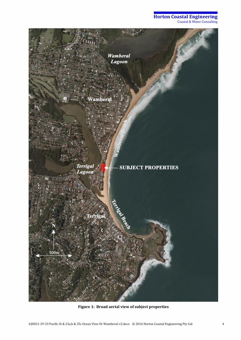
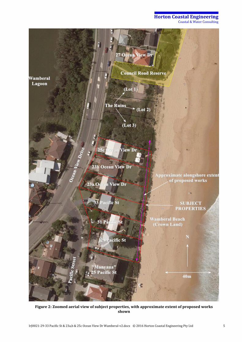
The subject properties are located towards the southern end of Wamberal Beach, about 300m north of the Terrigal Lagoon entrance. Broad and zoomed aerial views of the subject properties are provided in Figure 1 and Figure 2 (aerial photograph taken 20 January 2010). Moving south to north, the Wamberal subject properties comprise:
29 Pacific Street (Lot 6 DP 8854); 31 Pacific Street (Lot 5 DP 8854); 33 Pacific Street (Lot 4 DP 8854); 23a Ocean View Drive (Lot 3 DP 8854); 23b Ocean View Drive (Lot 2 DP 8854); and 25c Ocean View Drive (Lot 4 DP 524938).
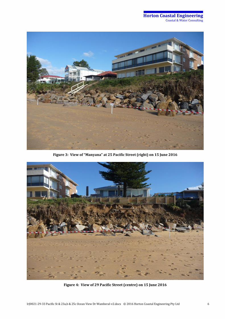
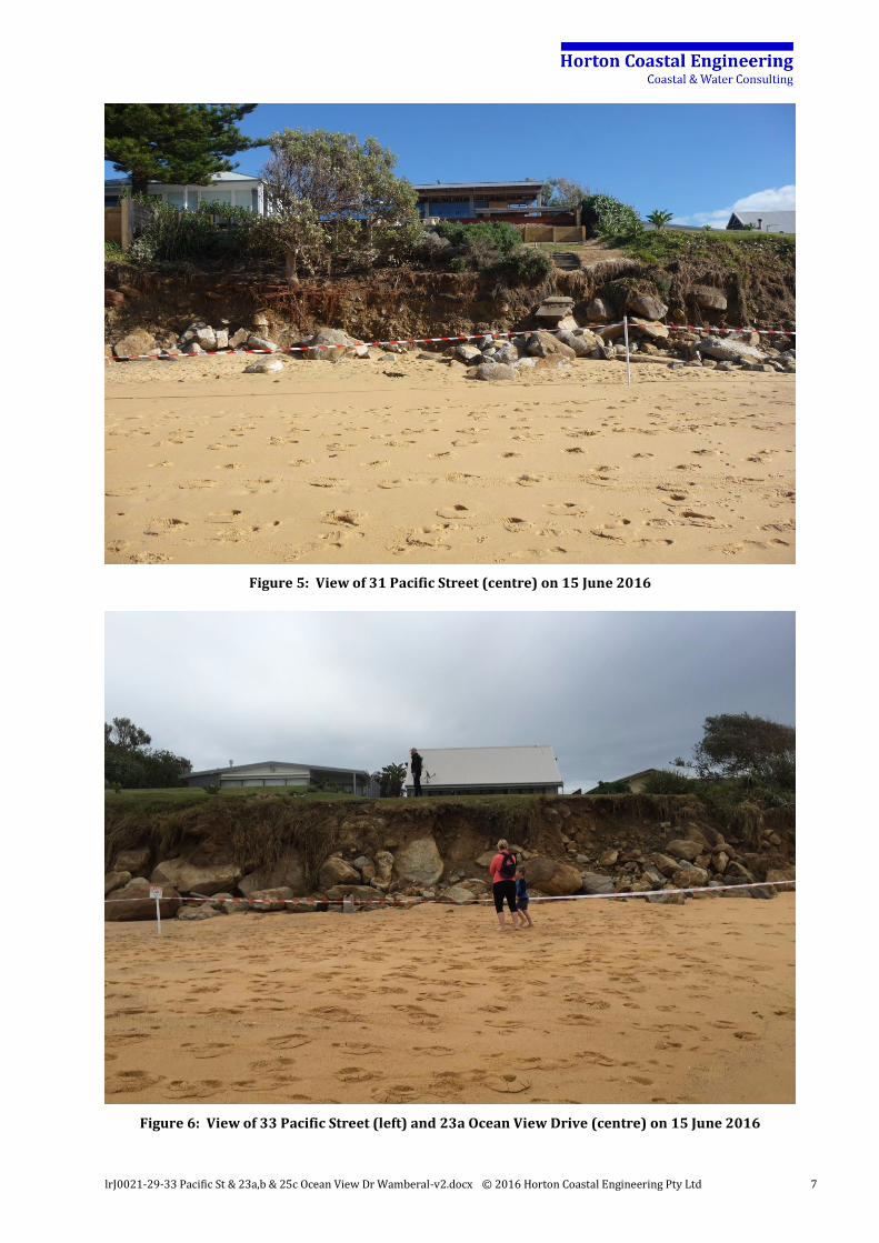
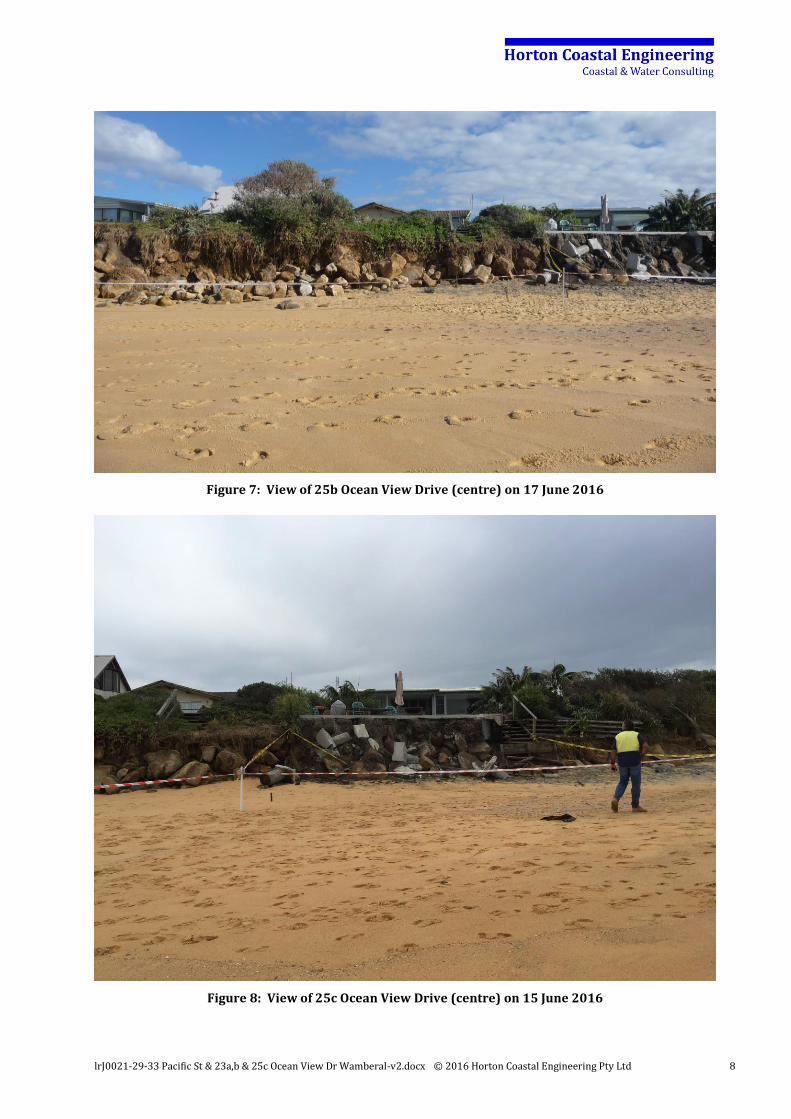
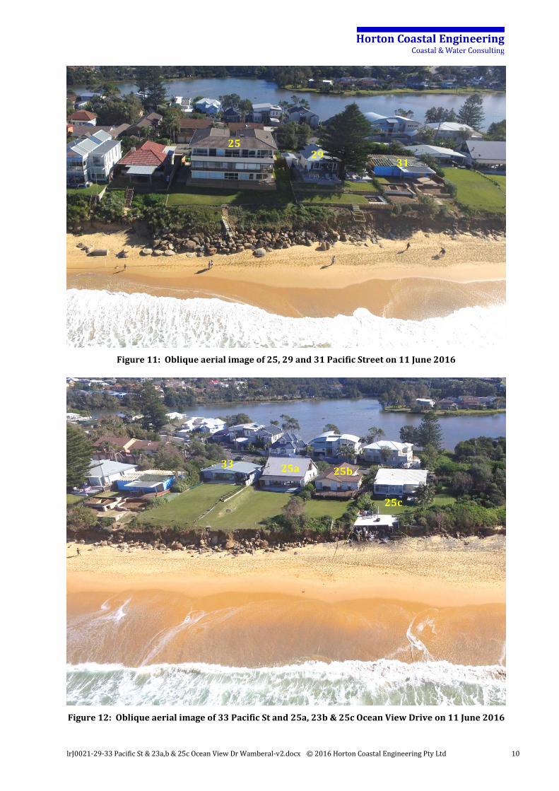
The subject properties had some rocks and boulders evident over their seaward portions after the June 2016 storm, but did not appear to have protection works of integrity over the full frontage or to the land crest height at any property. Immediately south of the subject properties is the “Manyana” unit block at 25 Pacific Street2, which was the subject of the so-called Egger Case3. This unit block has intact protection works located along the seaward beach frontage of sufficient integrity to tie the proposed protection works into. Immediately north of the subject properties is public land known as “The Ruins”, comprising three lots, namely Lot 3, Lot 2 and Lot 1 in DP 524938 (25b, 25a and 25 Ocean View Drive respectively). These three lots are owned by the Department of Planning and Environment and are under the care, control and management of Central Coast Council. A small portion of the proposed works is to extend onto this land (specifically, on to part of Lot 3 DP 524938). This extension on to public land is necessary to transition the revetment at 25c Ocean View Drive to this unprotected area to the north. It is not possible to suddenly end the revetment at the northern property boundary of 25c Ocean View Drive, as the revetment would then be at risk of instability with a sheer face at the boundary. North of “The Ruins” is a Council road reserve, and then private property commencing at 27 Ocean View Drive and extending north along most of the remainder of the beachfront to Wamberal SLSC. The 27 Ocean View Drive property is about 70m north of the subject properties. Seaward of the subject properties the land is Crown Land under the care, control and management of Central Coast Council. A portion of the proposed works extends on to this Crown Land consistent with the previous adopted protection works alignment adopted by Gosford Council in 2004, that would almost always be buried under sand. Photographs after the June 2016 storm (moving south to north) of “Manyana” (25 Pacific Street), the subject properties, and The Ruins are provided in Figure 3 to Figure 10. Oblique aerial imagery supplied by the Water Research Laboratory of the University of New South Wales taken after the June 2016 storm is provided in Figure 11 and Figure 12.
2 Note that there is a mismatch between the surveyed southern property boundary at 29 Pacific Street (red in Figure 2) and the northern boundary of Manyana (black in Figure 2) sourced from Council’s GIS cadastre, although this does not significantly influence the investigation reported herein. 3 Egger v Gosford Shire Council in the Supreme Court of NSW No. 14992 of 1979, with judgement given on 10 July 1987.
lrJ0021-29-33 Pacific St & 23a,b & 25c Ocean View Dr Wamberal-v2.docx © 2016 Horton Coastal Engineering Pty Ltd 4
Figure 1: Broad aerial view of subject properties
lrJ0021-29-33 Pacific St & 23a,b & 25c Ocean View Dr Wamberal-v2.docx © 2016 Horton Coastal Engineering Pty Ltd 5
Figure 2: Zoomed aerial view of subject properties, with approximate extent of proposed works shown
lrJ0021-29-33 Pacific St & 23a,b & 25c Ocean View Dr Wamberal-v2.docx © 2016 Horton Coastal Engineering Pty Ltd 6
Figure 3: View of “Manyana” at 25 Pacific Street (right) on 15 June 2016
Figure 4: View of 29 Pacific Street (centre) on 15 June 2016
lrJ0021-29-33 Pacific St & 23a,b & 25c Ocean View Dr Wamberal-v2.docx © 2016 Horton Coastal Engineering Pty Ltd 7
Figure 5: View of 31 Pacific Street (centre) on 15 June 2016
Figure 6: View of 33 Pacific Street (left) and 23a Ocean View Drive (centre) on 15 June 2016
lrJ0021-29-33 Pacific St & 23a,b & 25c Ocean View Dr Wamberal-v2.docx © 2016 Horton Coastal Engineering Pty Ltd 8
Figure 7: View of 25b Ocean View Drive (centre) on 17 June 2016
Figure 8: View of 25c Ocean View Drive (centre) on 15 June 2016
lrJ0021-29-33 Pacific St & 23a,b & 25c Ocean View Dr Wamberal-v2.docx © 2016 Horton Coastal Engineering Pty Ltd 9
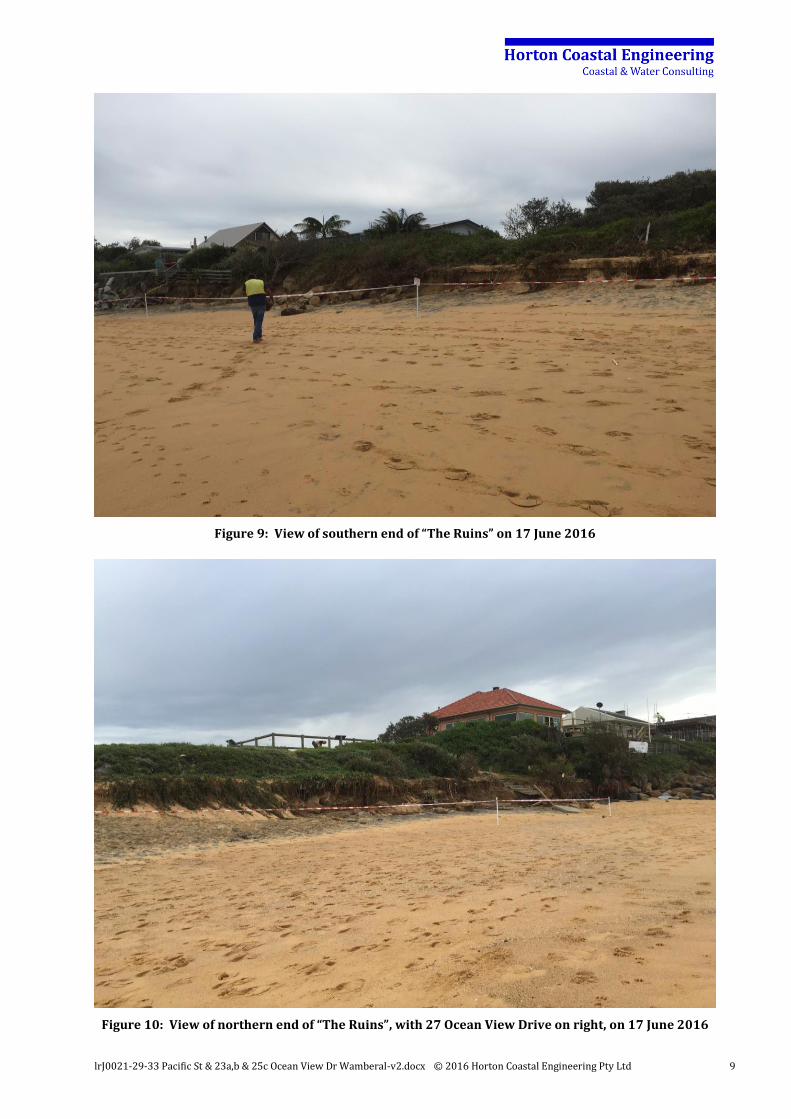
Figure 9: View of southern end of “The Ruins” on 17 June 2016
Figure 10: View of northern end of “The Ruins”, with 27 Ocean View Drive on right, on 17 June 2016
lrJ0021-29-33 Pacific St & 23a,b & 25c Ocean View Dr Wamberal-v2.docx © 2016 Horton Coastal Engineering Pty Ltd 10
Figure 11: Oblique aerial image of 25, 29 and 31 Pacific Street on 11 June 2016
Figure 12: Oblique aerial image of 33 Pacific St and 25a, 23b & 25c Ocean View Drive on 11 June 2016
25 29
31
33 25a 25b
25c
lrJ0021-29-33 Pacific St & 23a,b & 25c Ocean View Dr Wamberal-v2.docx © 2016 Horton Coastal Engineering Pty Ltd 11
3. COASTLINE HAZARDS
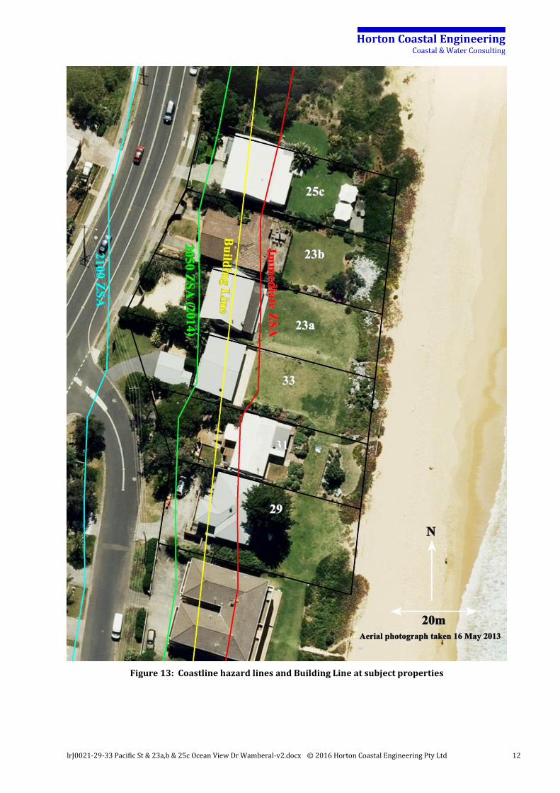
None of the subject properties (except 25a Ocean View Drive) are known to be on deep piled foundations, and it is unlikely that the piling at that property has been designed with consideration of contemporary coastal engineering requirements. Coastline hazards from erosion/recession have been well established in various studies over the last few decades at the subject properties. Coastline hazard lines at the subject properties defined in 2014 at the landward edge of the Zone of Slope Adjustment (ZSA), and for Immediate, 2050 and 2100 planning periods, are depicted in Figure 134. This indicates that all of the subject properties (except 33 Pacific Street) could be expected to be undermined in a severe 100-year Average Recurrence Interval (ARI) coastal storm at present, ignoring any effect of protection works limiting erosion at the properties. By 2050, the 100-year ARI storm could be expected to completely undermine the development at these properties, again ignoring protection works. That is, the necessity for protection works to be undertaken at these properties to enable development to remain at an acceptably low risk of damage has been well established5. A Coastal Building Line has been defined in Chapter 6.2 of Gosford Development Control Plan 2013 (DCP 2013)6, as also depicted in Figure 13. Based on DCP 2013, no new development is to be founded seaward of the Building Line. Furthermore, Council will not permit the redevelopment of existing buildings seaward of the Building Line unless the foundation design is demonstrated to have been constructed to withstand designated coastal processes and is certified by a coastal and structural engineer. This essentially means that the subject properties are undevelopable in the future (except under existing use rights), which is a further reason for the necessity for protection works to be undertaken at these properties to enable development to be maintained.
4 Based on the Open Coast and Broken Bay Beaches Coastal Processes and Hazard Definition Study, Revision E (Final) dated 24 February 2014, and endorsed by Gosford Council on 25 March 2014. 5 Appropriately designed and constructed piled foundations could potentially maintain the structural integrity of any undermined structure, but the effect of losing land around such a structure would potentially be a significant impact on the use of the land and access to the structure. 6 The DCP2013 version effective 19 August 2016 was reviewed for the report herein.
lrJ0021-29-33 Pacific St & 23a,b & 25c Ocean View Dr Wamberal-v2.docx © 2016 Horton Coastal Engineering Pty Ltd 12
Figure 13: Coastline hazard lines and Building Line at subject properties
lrJ0021-29-33 Pacific St & 23a,b & 25c Ocean View Dr Wamberal-v2.docx © 2016 Horton Coastal Engineering Pty Ltd 13
4. HISTORICAL SETTING
4.1 Historical Damage and Protective Works
As noted by the author in the Coastal Erosion Emergency Action Subplan for Wamberal-Terrigal Beach, development along Wamberal-Terrigal Beach has been threatened, damaged or destroyed by the action of coastal storms, particularly in the 1960’s, 1974 and 19787. As a result, rock and other material has been placed at some locations in an attempt to prevent property damage. Specifically:
major storms of May-June 1974 caused severe erosion of Central Coast beaches, and a house at the northern end of Wamberal-Terrigal Beach was severely damaged; and
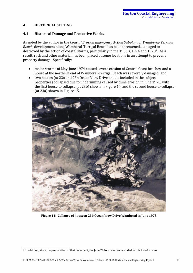
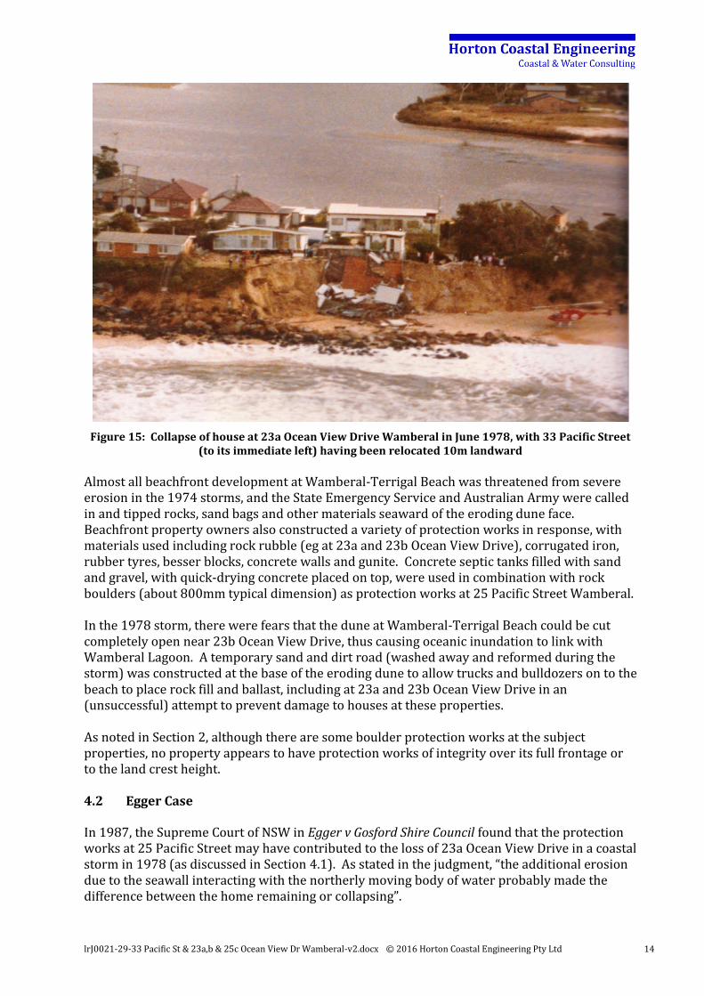
two houses (at 23a and 23b Ocean View Drive, that is included in the subject properties) collapsed due to undermining caused by dune erosion in June 1978, with the first house to collapse (at 23b) shown in Figure 14, and the second house to collapse (at 23a) shown in Figure 15.
Figure 14: Collapse of house at 23b Ocean View Drive Wamberal in June 1978
7 In addition, since the preparation of that document, the June 2016 storm can be added to this list of storms.
lrJ0021-29-33 Pacific St & 23a,b & 25c Ocean View Dr Wamberal-v2.docx © 2016 Horton Coastal Engineering Pty Ltd 14
Figure 15: Collapse of house at 23a Ocean View Drive Wamberal in June 1978, with 33 Pacific Street (to its immediate left) having been relocated 10m landward
Almost all beachfront development at Wamberal-Terrigal Beach was threatened from severe erosion in the 1974 storms, and the State Emergency Service and Australian Army were called in and tipped rocks, sand bags and other materials seaward of the eroding dune face. Beachfront property owners also constructed a variety of protection works in response, with materials used including rock rubble (eg at 23a and 23b Ocean View Drive), corrugated iron, rubber tyres, besser blocks, concrete walls and gunite. Concrete septic tanks filled with sand and gravel, with quick-drying concrete placed on top, were used in combination with rock boulders (about 800mm typical dimension) as protection works at 25 Pacific Street Wamberal. In the 1978 storm, there were fears that the dune at Wamberal-Terrigal Beach could be cut completely open near 23b Ocean View Drive, thus causing oceanic inundation to link with Wamberal Lagoon. A temporary sand and dirt road (washed away and reformed during the storm) was constructed at the base of the eroding dune to allow trucks and bulldozers on to the beach to place rock fill and ballast, including at 23a and 23b Ocean View Drive in an (unsuccessful) attempt to prevent damage to houses at these properties. As noted in Section 2, although there are some boulder protection works at the subject properties, no property appears to have protection works of integrity over its full frontage or to the land crest height. 4.2 Egger Case
In 1987, the Supreme Court of NSW in Egger v Gosford Shire Council found that the protection works at 25 Pacific Street may have contributed to the loss of 23a Ocean View Drive in a coastal storm in 1978 (as discussed in Section 4.1). As stated in the judgment, “the additional erosion due to the seawall interacting with the northerly moving body of water probably made the difference between the home remaining or collapsing”.
lrJ0021-29-33 Pacific St & 23a,b & 25c Ocean View Dr Wamberal-v2.docx © 2016 Horton Coastal Engineering Pty Ltd 15
Therefore, since 1987, there has been an awareness that (based on law) the 25 Pacific Street seawall may cause an adverse impact on adjacent properties, including the subject properties (and indeed may have done so in the June 2016 storm). The proposed works would mitigate against this potential adverse impact. 4.3 Coastal Management Plan in 1995
The document Coastal Management Study and Coastal Management Plan, Gosford City Open Coast Beaches (Gosford City Council, 1995) was adopted by Council in August 1995. In this, it was stated as a recommended action for Wamberal-Terrigal Beach that “a terminal protection structure in the nature of a buried rock revetment is to be designed and constructed to the satisfaction of Council and NSW Public Works, such construction to occur as soon as practicable and in an orderly, co-ordinated manner”. The proposed works are consistent with this action adopted 21 years ago. 4.4 Design Study for Wamberal Beach Protective Structure
Couriel et al (1998) completed detailed design of the terminal protection structure (revetment) at Wamberal-Terrigal Beach. It was proposed that the works extended over the entire length of beach from north of Terrigal Lagoon in the south to Wamberal SLSC in the north, including the subject properties. The design mostly comprised a Seabee armoured revetment (Seabee’s are proprietary hexagonal units that are pattern placed), extending from -1m AHD up to 6m to 8m AHD at a slope of 1:1.5 (vertical:horizontal), with additional scour protection using a rock-filled gabion and reno mattress toe. Couriel et al (1998) noted that the revetment would only become visible after major storms. An identical toe alignment to that adopted by Couriel et al (1998) has been adopted for the proposed revetment herein, constructed partly on private land and partly on public land. A 3m setback between existing dwellings and the landward edge of the revetment was adopted by Couriel et al (1998) to allow for access during construction, possible wave overtopping and any required maintenance following major storms. Note that coastal engineering practice has evolved since completion of Couriel et al (1998). It is considered preferable to avoid the use of a pattern placed structure (Seabees) due to its potential to fail catastrophically and given that is difficult to repair/maintain. The use of a gabion and reno mattress toe is also less favoured due to the potential for damage and contact with wire if exposed. Discussions of the author with Central Coast Council and Office of Environment and Heritage Staff indicated similar views. 4.5 Development Control Plan No. 125
Development Control Plan No. 125 – Coastal Frontage (DCP 125) of Gosford Council came into effect in January 2000. This allowed piled development to be constructed along Wamberal Beach, as long as it was set back from the alignment of the proposed revetment. DCP 125 was integrated into Gosford Development Control Plan 2013 which came into effect in February 2014.
lrJ0021-29-33 Pacific St & 23a,b & 25c Ocean View Dr Wamberal-v2.docx © 2016 Horton Coastal Engineering Pty Ltd 16
4.6 Wamberal Beach Protective Works Environment Impact Statement in 2003
As noted in Section 1.1, an Environment Impact Statement (EIS) for the Wamberal Beach Protective Works was prepared by MHL (2003). Gosford Council was the proponent for the works. The EIS proposal was for both a revetment and beach nourishment, but as a sand source could not be determined for the beach nourishment, the nourishment component of the EIS was not finalised. However, the revetment option was fully assessed. The revetment proposed herein follows the same alignment proposed in MHL (2003). MHL (2003) evaluated a range of alternative options to the revetment, including do nothing, planning controls, planned retreat, groynes, offshore breakwaters, artificial surfing reefs, submerged shore parallel reef systems, beach drains, pressure equalisation modules, piled foundations, dune management, property acquisition, and large scale sand nourishment. These alternative options were dismissed as being less suitable in isolation, or necessary to combine with the revetment option to be effective. The MHL (2003) investigation included a range of community (including the Darkinjung Aboriginal Land Council), landowner and government consultation activities. Government agencies consulted with included the then Department of Housing, Department of Land and Water Conservation, Department of Mineral Resources, Department of Urban Affairs and Planning, Environment Protection Authority, NSW Fisheries, NSW Heritage Office, NSW National Parks and Wildlife Service, and the Roads and Traffic Authority. MHL (2003) noted that the revetment option needed to be accompanied by periodic maintenance sand nourishment to maintain beach amenity. This is not considered to be a private landowner responsibility and hence is not part of the proposed works herein. It is expected that beach nourishment would be facilitated and funded by Council and State Government, as was also envisaged by MHL (2003). MHL (2003) expected that the works would be 50% funded by State Government and 50% by landowners to protect private land, and funded by State Government and/or Council to protect public land. 4.7 Adopted Council Strategy in 2004
At its Ordinary Meeting on 27 July 2004, Gosford Council adopted the Couriel et al (1998) / MHL (2003) revetment as the preferred protective strategy for Wamberal Beach. It was confirmed at that time that the proposed revetment had been fully assessed in accordance with all relevant provisions of the Environmental Planning and Assessment Act 19798. Council accordingly embarked upon the process of seeking external funding for the works, but has been unsuccessful to date, some 12 years later. Council noted that it was proposed that costs would be shared between the Federal Government, State Government, Council and private landowners. 4.8 Amendment to Gosford Development Control Plan 2013 in June 2015
At its meeting on 10 February 2015, Gosford Council noted that the proposed revetment for Wamberal Beach had not yet been able to be funded or constructed in the 20 years since it was first proposed, and required redesign to meet updated coastal processes hazard information.
8 As noted in the Agenda for the Gosford Council Ordinary Meeting on 9 June 2015, page 165.

lrJ0021-29-33 Pacific St & 23a,b & 25c Ocean View Dr Wamberal-v2.docx © 2016 Horton Coastal Engineering Pty Ltd 17
Accordingly, in June 2015, Chapter 6.2 of Gosford Development Control Plan 2013 (DCP 2013) was amended to no longer allow new development along Wamberal Beach that had previous been permitted on the basis of DCP 125 under the assumption that the Wamberal revetment would be constructed (Section 4.5). As noted in Section 3, this essentially means that the subject properties are undevelopable in the future (except under existing use rights) without construction of protective works, which is a further reason for the necessity for protection works to be undertaken at these properties to enable development to be maintained. It was envisaged as part of the DCP 2013 amendments that construction of the Wamberal revetment would allow these residential development restrictions to be rescinded. 4.9 Gosford Beaches Draft Coastal Zone Management Plan
As discussed in Section 1.1, the Gosford Beaches Draft Coastal Zone Management Plan (CZMP) has been submitted to the Minister for Planning for gazettal. For Wamberal Beach, a management action (TW11) was included that Council action review, design and funding of the revetment. This was considered to be a buried armour revetment, as has been proposed herein. That is, the CZMP maintained the aim to have the Wamberal revetment constructed. However, this was listed as a short-medium term action (up to 20-year timeframe) with more studies required and funding still not resolved. Landowners, who have been waiting for over 20 years for the Wamberal revetment to be implemented, cannot be expected to continue to wait considering the risk to development and uncertain timeframe for this action. It is reasonable for them to be submitting the application herein, proactively achieving what governments have been unable to achieve for decades. The CZMP also included an action (TW27) that erosion (actually “coastal”) protection works be allowed at properties at Wamberal, consistent with the application herein. Actions (TW3, TW14) were also included in the CZMP that Council investigate beach nourishment to increase the sand buffer against storm erosion. Action TW15 also noted that beach nourishment should be coupled with the Wamberal revetment as a public authority responsibility. 4.10 Synthesis
The proposed works as outlined herein are implementing the principles of what has been:
proposed for decades; subject to environmental assessment; subject to community consultation; subject to Government agency consultation; formally adopted by Council; found by Council to be fully assessed in accordance with all relevant provisions of the
Environmental Planning and Assessment Act 1979; and listed as an action in the CZMP.
The works would also prevent an end effect that the Supreme Court found to be present at the subject properties. The fact that landowners have even had to submit this application is indicative of failures in effective coastal management in NSW over the last 40 years. To review
lrJ0021-29-33 Pacific St & 23a,b & 25c Ocean View Dr Wamberal-v2.docx © 2016 Horton Coastal Engineering Pty Ltd 18
the historical setting outlined in previous sections, where houses at the subject properties were destroyed by erosion 38 years ago and an effective solution dealing with the risk to property has still not been implemented, makes the current application all the more appropriate.
lrJ0021-29-33 Pacific St & 23a,b & 25c Ocean View Dr Wamberal-v2.docx © 2016 Horton Coastal Engineering Pty Ltd 19
5. PROPOSED WORKS
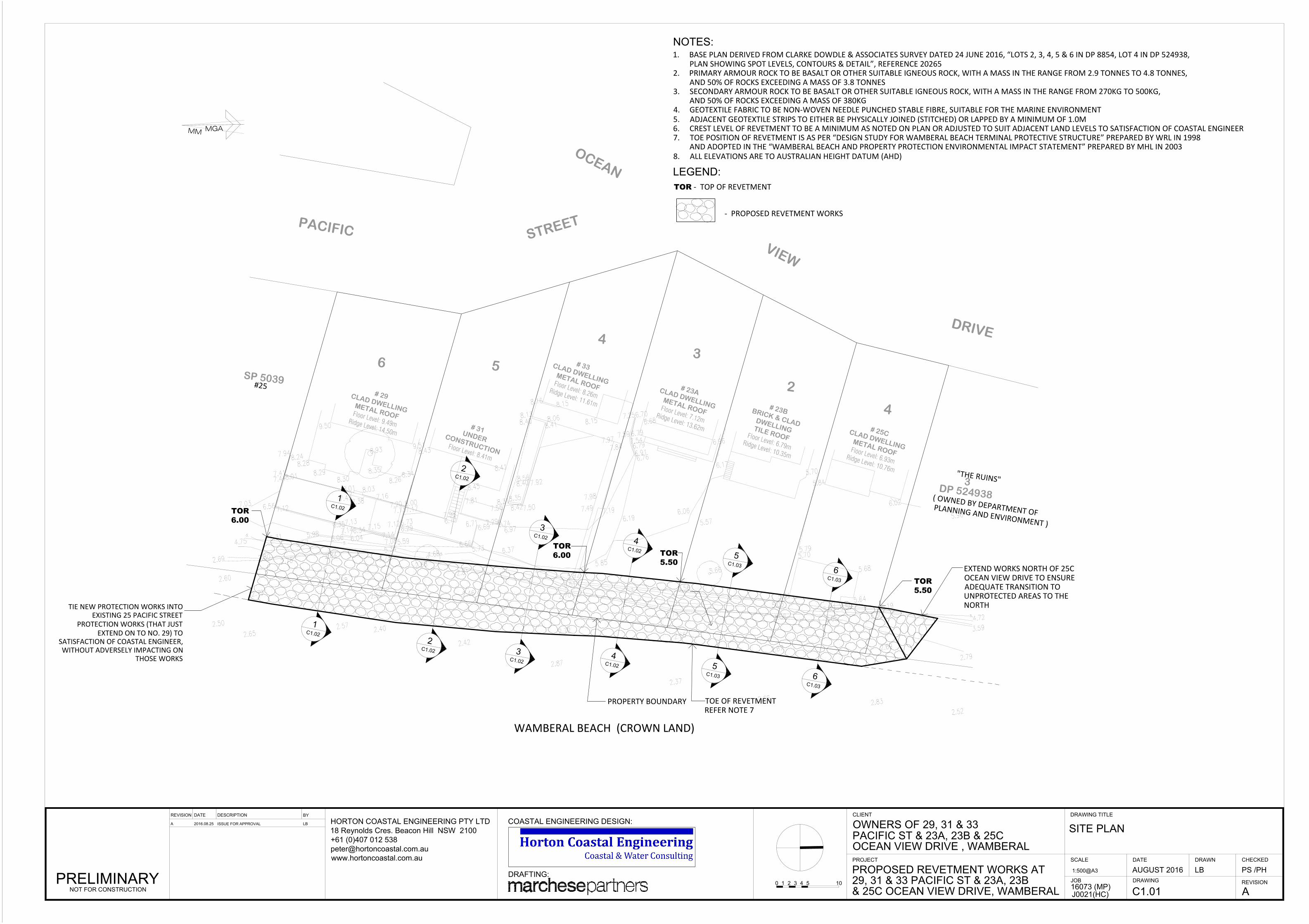
The proposed rock revetment works are described in plan and cross sections at each property on the Drawings C1.01, C1.02 and C1.03 provided in Appendix C. The main components of the works comprise a geotextile base to prevent washout of the soil landward, then two layers of secondary armour basalt rock (about 400kg mass or about 600mm typical dimension), then two layers of primary armour basalt rock (about 4 tonne mass or about 1.3m typical dimension). These dimensions may be refined by detailed design but will not change significantly. The works would link with the existing revetment at 25 Pacific Street in the south, and extend north of 25c Ocean View Drive to ensure a safe transition to the unprotected areas of The Ruins further north. The location of the toe of the revetment matches that proposed by Couriel et al (1998) and MHL (2003) and adopted by Council in 20049. This design standard is well established, for example in Seawall Design Criteria for Collaroy-Narrabeen Beach. It would be expected that this design would withstand at least a 50-year Average Recurrence Interval (ARI) storm event over a 60-year design life. Some maintenance of the revetment may be required after severe storms, but due to the nature of a rock revetment, catastrophic failure is highly unlikely even if more severe events than the design event occur. Detailed design calculations will be undertaken to ensure that the design (essentially rock size) is sufficient to withstand a 50 year ARI storm occurring over the next 60 years, or other reasonable standard as agreed with the consent authority. A toe level of -1m AHD has been adopted for the proposed revetment. The crest level of the revetment would match or exceed the level of the land behind, and is expected to vary from at least 6m AHD in the south to 5.5m AHD in the north. The contractor would be responsible for undertaking a services search and obtaining all required permits prior to works commencing. Site office and storage areas would be set up as agreed between the contractor and Council, as was envisaged in MHL (2003). It is expected that materials such as backfill and armour rock would be delivered by truck to the southern end of Pacific Street10 and unloaded into a fenced off work zone as agreed with Council. The materials would then be loaded by say a 25 tonne excavator on to say 25 tonne rear dump trucks to be transported along Wamberal Beach to the subject properties. There would be traffic control and spotters to ensure the safety of the public during the works. Beach sand would need to be excavated to establish the revetment toe at -1m AHD, and the excavation would need to temporarily extend seaward of the toe. A maximum (steepest) side slope of approximately 1:2 (vertical: horizontal) would be required for any excavation of the beach sand. Sand may temporarily be mounded to assist in preventing wave action from affecting the works area. Any existing rock over the revetment footprint would be picked up and stockpiled for reuse in the new revetment as agreed by a coastal engineer. There would be a general preference for
9 It would not be possible to move the revetment further landward as it would then not link up appropriately with 25 Pacific Street, would undermine retaining wall structures at 29 and 31 Pacific Street, and not have a sufficient distance to allow for future revetment maintenance seaward of these retaining wall structures (a maintenance setback distance of 3m was adopted in Couriel et al [1998] and MHL [2003]). See Appendix D for further explanation. 10 The southern end of Pacific Street was noted as a possible works site access location in MHL (2003), as was The Ruins.
lrJ0021-29-33 Pacific St & 23a,b & 25c Ocean View Dr Wamberal-v2.docx © 2016 Horton Coastal Engineering Pty Ltd 20
using this stockpiled rock as the lower of the primary two armour layers. Any existing excavated materials that would be unsuitable to reuse in the revetment would be picked up and either stockpiled for use as backfill (if suitable), or removed to an approved off-site waste disposal facility if unsuitable for use as backfill. The alongshore length of construction at any one time would be about 20m, while preparation is commenced on the next 20m section. It is expected that construction would proceed from south to north. It is expected that the works would be undertaken over a period of about 40 working days11. The contractor would be responsible for maintaining the site and works area in a safe and secure condition, and be responsible for rehabilitating the site following completion of the works. Following the completion of construction, the revetment would be buried under sand, and would remain buried under sand for most of the time, as discussed further in Appendix D. In the long term under recession due to sea level rise, the revetment may become exposed more often if beach nourishment is not undertaken, as envisaged in MHL (2003). Based on a quotation received from a contractor, the estimated cost of the works is about $1.5 million.
11 Note that MHL (2003) envisaged construction over 10 months for the entire Wamberal revetment.
lrJ0021-29-33 Pacific St & 23a,b & 25c Ocean View Dr Wamberal-v2.docx © 2016 Horton Coastal Engineering Pty Ltd 21
6. PLANNING CONTEXT
Based on Clause 129A(1) of State Environmental Planning Policy (Infrastructure) 2007 (SEPP Infrastructure), the proposed works are permissible with consent. Therefore, Part 4 of the Environmental Planning and Assessment Act 1979 applies to the works. As noted in Section 1.1, given that the study area does not have a gazetted CZMP, the Coastal Panel has the function of determining the DA. The subject properties are zoned as R2 (Low Density Residential) in Gosford Local Environmental Plan 2014 (LEP 2014). The beach seaward of the subject properties, and The Ruins, are both zoned as RE1 (Public Recreation). Coastal protection works are not specifically permitted in these zones. However, SEPP Infrastructure prevails over LEP 2014. Furthermore, non-inclusion of protection works as being permitted in these zones is considered to be related more to the restrictive nature of the Standard Instrument -Principal Local Environmental Plan rather than any deliberate intention of Council to exclude these works12. A Statement of Environmental Effects is required to accompany the DA for the proposed protection works. Based on the Environmental Planning and Assessment Regulation 2000, this Statement of Environmental Effects must include consideration of the environmental impacts of the development, how the environmental impacts of the development have been identified, and the steps to be taken to protect the environment or to lessen the expected harm to the environment. The Statement of Environmental Effects is incorporated into Section 7 herein. The proposed works are not considered to be integrated development as:
no reclamation is being carried out in a waterway (the works are in an area that will usually be buried under sand) in relation to the Fisheries Management Act 1994; and
the works are not a controlled activity based on the Water Management Act 2000 as this does not apply to this open coast beach area (which is covered by the Coastal Protection Act 1979) as per Department of Primary Industries – Water (2016).
12 This anomaly is common to many Local Government Areas where coastal protection works are considered to be appropriate, including the Warringah Local Environmental Plan 2011 applying to Collaroy-Narrabeen Beach.
lrJ0021-29-33 Pacific St & 23a,b & 25c Ocean View Dr Wamberal-v2.docx © 2016 Horton Coastal Engineering Pty Ltd 22
7. MERIT ASSESSMENT AND STATEMENT OF ENVIRONMENTAL EFFECTS
7.1 Preamble
As the consent authority and based on Clause 129A(3) of SEPP Infrastructure, the NSW Coastal Panel must take the following matters into consideration:
(a) the provisions of any coastal zone management plan applying to the land, (b) the matters set out in clause 8 of State Environmental Planning Policy No 71—Coastal
Protection (SEPP 71), and (c) any guidelines for assessing and managing the impacts of coastal protection works that
are issued by the Director-General for the purposes of this clause and published in the Gazette.
Although not gazetted, the draft CZMP that applies to the study area is relevant for consideration as per (a) above, and is discussed further in Section 7.2. SEPP 71 matters as per (b) above are discussed in Section 7.3. No specific guidelines for assessing and managing the impacts of coastal protection works have been issued as per (c) above, but draft guidelines in this regard are considered in Section 7.4. Section 55M of the Coastal Protection Act 1979 sets out preconditions to the granting of development consent relating to coastal protection works13. Consent must not be granted under the Environmental Planning and Assessment Act 1979 to development for the purpose of coastal protection works, unless the consent authority is satisfied of certain matters as listed and considered in Section 7.5. Gosford Local Environmental Plan 2014 and Gosford Development Control Plan 2013 have also been considered in Section 7.6 and Section 7.7 respectively. On the NSW Coastal Panel Development Application form, it is stated that an “offsite erosion impact management plan including ongoing maintenance costs” is required. This is considered in Section 7.8. The environmental impacts of the proposed works are assessed in accordance with Section 79C of the Environmental Planning and Assessment Act 1979 in Section 7.9. The discussion below is somewhat repetitive due to the various pieces of legislation and Environmental Planning Instruments that have been considered that overlap in content. 7.2 Consistency with CZMP
As discussed in Section 4.9, the proposed works are consistent with the CZMP, which included actions that a revetment is constructed at Wamberal Beach, and that landowners may construct coastal protection works.
13 Note that Section 27 of the Coastal Management Act 2016 (which has been assented to but is not likely to be in force until 1 January 2017 based on personal communication from Minister for Planning Rob Stokes), which is to replace the Coastal Protection Act 1979, has identical wording.
lrJ0021-29-33 Pacific St & 23a,b & 25c Ocean View Dr Wamberal-v2.docx © 2016 Horton Coastal Engineering Pty Ltd 23
7.3 SEPP 71 Matters
7.3.1 Matters for Consideration
As the proposed development is within the Coastal Zone14, SEPP 71 applies. The matters for consideration listed in Clause 8 of SEPP 71 are as follows: (a) the aims of this Policy set out in clause 2, (b) existing public access to and along the coastal foreshore for pedestrians or persons with
a disability should be retained and, where possible, public access to and along the coastal foreshore for pedestrians or persons with a disability should be improved,
(c) opportunities to provide new public access to and along the coastal foreshore for pedestrians or persons with a disability,
(d) the suitability of development given its type, location and design and its relationship with the surrounding area,
(e) any detrimental impact that development may have on the amenity of the coastal foreshore, including any significant overshadowing of the coastal foreshore and any significant loss of views from a public place to the coastal foreshore,
(f) the scenic qualities of the New South Wales coast, and means to protect and improve these qualities,
(g) measures to conserve animals (within the meaning of the Threatened Species Conservation Act 1995) and plants (within the meaning of that Act), and their habitats,
(h) measures to conserve fish (within the meaning of Part 7A of the Fisheries Management Act 1994) and marine vegetation (within the meaning of that Part), and their habitats
(i) existing wildlife corridors and the impact of development on these corridors, (j) the likely impact of coastal processes and coastal hazards on development and any
likely impacts of development on coastal processes and coastal hazards, (k) measures to reduce the potential for conflict between land-based and water-based
coastal activities, (l) measures to protect the cultural places, values, customs, beliefs and traditional
knowledge of Aboriginals, (m) likely impacts of development on the water quality of coastal waterbodies, (n) the conservation and preservation of items of heritage, archaeological or historic
significance, (o) only in cases in which a council prepares a draft local environmental plan that applies
to land to which this Policy applies, the means to encourage compact towns and cities, (p) only in cases in which a development application in relation to proposed development
is determined: (i) the cumulative impacts of the proposed development on the environment, and (ii) measures to ensure that water and energy usage by the proposed development is
efficient. These matters are discussed in turn below. 7.3.2 Item 8(a) – Aims
For item 8(a), the aims of the policy in Clause 2 are as follows: (a) to protect and manage the natural, cultural, recreational and economic attributes of the
New South Wales coast, and
14 As per the map “Coastal Zone, NSW Coastal Protection Act 1979, Greater Metropolitan Region, Map 7”.
lrJ0021-29-33 Pacific St & 23a,b & 25c Ocean View Dr Wamberal-v2.docx © 2016 Horton Coastal Engineering Pty Ltd 24
(b) to protect and improve existing public access to and along coastal foreshores to the extent that this is compatible with the natural attributes of the coastal foreshore, and
(c) to ensure that new opportunities for public access to and along coastal foreshores are identified and realised to the extent that this is compatible with the natural attributes of the coastal foreshore, and
(d) to protect and preserve Aboriginal cultural heritage, and Aboriginal places, values, customs, beliefs and traditional knowledge, and
(e) to ensure that the visual amenity of the coast is protected, and (f) to protect and preserve beach environments and beach amenity, and (g) to protect and preserve native coastal vegetation, and (h) to protect and preserve the marine environment of New South Wales, and (i) to protect and preserve rock platforms, and (j) to manage the coastal zone in accordance with the principles of ecologically sustainable
development (within the meaning of section 6(2) of the Protection of the Environment Administration Act 1991), and
(k) to ensure that the type, bulk, scale and size of development is appropriate for the location and protects and improves the natural scenic quality of the surrounding area, and
(l) to encourage a strategic approach to coastal management. For aim 2(a), it can be noted that the proposed works are consistent with Council’s adopted strategy for Wamberal Beach and the CZMP. As part of the CZMP process, management options were subject to community consultation and assessed based on cost benefit analysis (economic), environmental (natural) and social (cultural/recreational) aspects. Therefore, by definition, the adopted CZMP action of a revetment at the subject properties supports the natural, cultural, recreational and economic attributes of the NSW coast. The works are essential to support the economic attributes of the residential land, and the works would not interfere with public recreational opportunities on public land15. For aims 2(b) and (c), the proposed development would have no significant effect on public beach access, which is currently possible north and south of the subject properties, and will be available alongshore for over 99% of the time (based on historical behaviour16) as discussed in Appendix D. For aim 2(d), MHL (2003) investigated Aboriginal heritage impacts and found no issues. For aim 2(e), MHL (2003) considered that the Wamberal revetment would lead to a long term improvement of visual amenity, as there would no longer be ad hoc protection works getting exposed after storms and deleterious materials being scattered on the beach. As discussed in Appendix D, the proposed revetment would generally be buried under sand.
15 The encroachment of the works on to public land is consistent with the existing encroachment of the works at 25 Pacific Street on to public land (which has been in place since 1974, that is for 42 years), the Wamberal revetment alignment established from 1998 to 2003 and adopted by Council in 2004, and is at such a depth below the sand that the works would only be exposed for a short period (days) on public land after severe storms and would be covered by sand naturally by beach recovery after the storm. An assessment of historical sand levels in relation to the proposed works is provided in Appendix D, which indicated that the portion of works on public land (had the revetment been constructed) would have been exposed for only a few months over the last 75 years, and only over the southern 20% of the works. 16 It is recognised that long term recession may increase the percentage of time that the revetment is exposed on public land, but as per MHL (2003) and the CZMP, if beach nourishment is undertaken as has been actioned this would be resolved. The subject owners cannot take on responsibility for this nourishment action, and can only ask that it is implemented by Council as actioned in the CZMP.
lrJ0021-29-33 Pacific St & 23a,b & 25c Ocean View Dr Wamberal-v2.docx © 2016 Horton Coastal Engineering Pty Ltd 25
For aim 2(f), the proposed works would cause a short term impact on beach amenity (eg through noise and some restriction on alongshore beach access) during the 40-day construction period, which is unavoidable, as was also envisaged by MHL (2003). As the impacts are short term and localised they can be accepted. The residents most exposed to the increased noise levels during construction will be benefiting from the security to development offered by the proposed revetment and will have both contributed to the cost and given approval for the work to proceed on their properties (MHL, 2003). To reduce the noise impacts during construction, working hours for plant and equipment would be restricted (as per the NSW Interim Construction Noise Guideline) to between 7am and 6pm from Monday to Friday, and 8am to 1pm on Saturday. No work would be undertaken on Sundays or public holidays. During the 40 working day construction period, the number of truck deliveries would be in the order of an average of 8 to 9 per day, or less than 1 per working hour. As noted by MHL (2003), the presence of the proposed revetment would not result in the loss of additional sand from the beach seaward of the structure. It will have no long term impact on beach amenity if beach nourishment is undertaken as actioned in the CZMP (and the requirement for nourishment is not a function of the revetment, but a function of long term recession due to sea level rise occurring, which will occur independently of the proposed works and at a rate completely unrelated to the works). For aim 2(g), it can be noted that native coastal vegetation is limited in the vicinity of the subject properties. MHL (2003) found that no vulnerable nor endangered plant species were likely to be affected by the proposed works. As part of the proposed construction, a small vegetated area at The Ruins may be disturbed, which would be restored by the contractor and also naturally revegetate at the completion of the revetment works. A larger area of vegetation at The Ruins was disturbed by the June 2016 storm. For aim 2(h), an aquatic ecology report prepared by The Ecology Lab as part of MHL (2003) found that there would be no significant impacts on marine fauna and flora as result of the Wamberal revetment construction, for which the proposed works are a small subset. As noted in MHL (2003), construction will essentially be carried out above the high water mark and for this reason will not directly impact on fish or their habitat. A small area of beach and dune face that birds may visit would not be available during construction, but there would be ample area to the north and south of the works for birds to access. For aim 2(i), no rock platforms are located within about 1.5km of the subject properties and hence the proposed works will have no impact on rock platforms. For aim 2(j), it can be noted that in section 6(2) of the Protection of the Environment Administration Act 1991 it is stated that “ecologically sustainable development requires the effective integration of economic and environmental considerations in decision-making processes. Ecologically sustainable development can be achieved through the implementation of the following principles and programs: (a) the precautionary principle - namely, that if there are threats of serious or irreversible
environmental damage, lack of full scientific certainty should not be used as a reason for
lrJ0021-29-33 Pacific St & 23a,b & 25c Ocean View Dr Wamberal-v2.docx © 2016 Horton Coastal Engineering Pty Ltd 26
postponing measures to prevent environmental degradation. In the application of the precautionary principle, public and private decisions should be guided by:
(i) careful evaluation to avoid, wherever practicable, serious or irreversible damage to the environment, and
(ii) an assessment of the risk-weighted consequences of various options, (b) inter-generational equity - namely, that the present generation should ensure that the
health, diversity and productivity of the environment are maintained or enhanced for the benefit of future generations,
(c) conservation of biological diversity and ecological integrity - namely, that conservation of biological diversity and ecological integrity should be a fundamental consideration,
(d) improved valuation, pricing and incentive mechanisms - namely, that environmental factors should be included in the valuation of assets and services, such as:
(iii) polluter pays - that is, those who generate pollution and waste should bear the cost of containment, avoidance or abatement,
(iv) the users of goods and services should pay prices based on the full life cycle of costs of providing goods and services, including the use of natural resources and assets and the ultimate disposal of any waste,
(v) environmental goals, having been established, should be pursued in the most cost effective way, by establishing incentive structures, including market mechanisms, that enable those best placed to maximise benefits or minimise costs to develop their own solutions and responses to environmental problems”.
The proposed works are in an already developed area, and as demonstrated by MHL (2003) for the entire Wamberal revetment, would not significantly impact on biological diversity. The works would not be a source of pollution and would not generate significant waste. For aim 2(k), the type, bulk, scale and size of the proposed development is appropriate for the location, having been adopted by Couriel et al (1998), MHL (2003), Council (in 2004) and in the CZMP as the key coastal management option for Wamberal Beach. As noted previously with regard to aim 2(e), MHL (2003) considered that the Wamberal revetment would lead to a long term improvement of visual amenity (scenic quality) of the area. For aim 2(l), the proposed works are consistent with the CZMP, which documents Council’s strategic approach to coastal management as endorsed by the NSW Government. 7.3.3 Item 8(b) and 8(c)
For Items 8(b) and 8(c) in Section 7.3.1, as discussed with regard to aims 2(b) and 2(c) in Section 7.3.2, the proposed works would not affect public beach access from landward areas at all, and would not affect alongshore beach access for over 99% of the time. 7.3.4 Item 8(d)
For Item 8(d) in Section 7.3.1, as discussed with regard to aim 2(k) in Section 7.3.2, the type, location and design of the proposed works is consistent with previous studies and has been adopted by Council by both resolution and in the CZMP as applying to the entire Wamberal Beach area.
lrJ0021-29-33 Pacific St & 23a,b & 25c Ocean View Dr Wamberal-v2.docx © 2016 Horton Coastal Engineering Pty Ltd 27
7.3.5 Item 8(e)
For Item 8(e) in Section 7.3.1, the proposed works would not overshadow the coastal foreshore any differently to a natural dune, and would have no effect on the extent of views from public places. 7.3.6 Item 8(f)
For Item 8(f) in Section 7.3.1, as discussed with regard to aims 2(e) and 2(k) in Section 7.3.2, MHL (2003) considered that the Wamberal revetment would lead to a long term improvement of visual amenity (scenic quality) of the area. 7.3.7 Item 8(g)
For Item 8(g) in Section 7.3.1, as discussed with regard to aim 2(g) in Section 7.3.2, no vulnerable nor endangered plant species are likely to be affected by the proposed works. As noted in Section 7.3.2, any disturbed areas would be restored by the contractor and also naturally revegetate at the completion of the revetment works. As discussed with regard to aim 2(h) in Section 7.3.2, a small area of beach and dune face that birds may visit would not be available during construction, but there would be ample area to the north and south of the works for birds to access. There would be some invertebrate fauna habitat removed during the construction process as the upper layer of the beach sand is excavated, stockpiled and replaced. The impact of this is comparable with natural erosion events and accretion cycles and it is not considered that this would result in significant ongoing impacts (MHL, 2003). MHL (2003) found that the proposed works were not likely to have a significant effect on threatened species, and therefore that a Species Impact Statement was not required. 7.3.8 Item 8(h)
For Item 8(h) in Section 7.3.1, as discussed with regard to aim 2(h) in Section 7.3.2, MHL (2003) found that there would be no significant impacts on marine fauna (including fish) and flora as result of the Wamberal revetment construction, for which the proposed works are a small subset. By keeping the proposed works separated from the ocean with a sand bund during construction, any potential impacts would be minimised. Even if the works area was exposed due to wave action, the nature of the armour rock would be such that it would not be mobile unless wave action was severe. After construction, the proposed works would have no significant impacts on marine fauna and flora, being buried under sand for most of the time. Indeed, the proposed works offer a better outcome for marine fauna and flora than the existing situation of deleterious materials being washed into the ocean after storms. 7.3.9 Item 8(i)
For Item 8(i) in Section 7.3.1, there are no wildlife corridors in the proposed works area.
lrJ0021-29-33 Pacific St & 23a,b & 25c Ocean View Dr Wamberal-v2.docx © 2016 Horton Coastal Engineering Pty Ltd 28
7.3.10 Item 8(j)
For Item 8(j) in Section 7.3.1, the proposed works would be designed to resist severe wave action and beach erosion for a suitably rare storm and long design life. Coastal processes and coastal hazards may cause some damage to the revetment in more severe storms than the design event, but a rock revetment is relatively accommodating of this and could most likely be repaired with a top up of rock after the storm event. As noted by MHL (2003), the proposed works would not result in the loss of additional sand from the beach seaward of the structure. The beach will naturally recover after storms and the revetment will again be covered by sand. There theoretically may be ‘end effects’ caused by the proposed revetment, as considered further in Section 7.4, although the subject property owners are considered to be entitled to protect themselves against the existing 25 Pacific Street revetment theoretical end effect that has been in place since 1974 by constructing protection works to link up with these adjacent works. The theoretical end effect caused by the proposed revetment only exists as the entire Wamberal revetment has not been implemented, and will no longer be present once that action is completed as adopted by Council in 2004 and actioned in the CZMP. The theoretical end effect should only be short term if the Wamberal revetment is finally implemented. The potential end effects of the proposed works are considered to be a less significant issue than failing to act on implementing the Wamberal revetment (as is essentially being commenced at the subject properties), as without the revetment residential dwellings are at an unacceptably high risk of damage. That is, the consequences of no revetment (leading to potential undermining of residential dwellings in a severe storm) are considered to far outweigh the theoretical end effect of the proposed works (potentially causing some additional erosion at The Ruins). 7.3.11 Item 8(k)
For Item 8(k) in Section 7.3.1, the proposed works have been situated as far landward as possible and to a consistent alignment as adopted in Couriel et al (1998), MHL (2003) and adopted by Council in 2004. The portion of the proposed works on public land would be buried under sand for over 99% of the time (based on historical behaviour) as noted in Section 7.3.2. 7.3.12 Item 8(l)
For Item 8(l) in Section 7.3.1, as discussed with regard to aim 2(d) in Section 7.3.2, MHL (2003) investigated Aboriginal heritage impacts and found no issues. Therefore, no specific measures to protect the cultural places, values, customs, beliefs and traditional knowledge of Aboriginals are required. 7.3.13 Item 8(m)
For Item 8(m) in Section 7.3.1, the impact of the proposed works on water quality would be similar to the effect on marine flora and fauna as discussed in Section 7.3.8. Also, note that excavated beach sand generally has a low potential for dust generation due to its relatively coarse grain size.
lrJ0021-29-33 Pacific St & 23a,b & 25c Ocean View Dr Wamberal-v2.docx © 2016 Horton Coastal Engineering Pty Ltd 29
7.3.14 Item 8(n)
For Item 8(n) in Section 7.3.1, there are no items of heritage, archaeological or historic significance that would be affected by the proposed works, as identified by MHL (2003). 7.3.15 Items 8(o) and 8(p)
Items 8(o) and 8(p) in Section 7.3.1 are not applicable to the proposed works. 7.3.16 Overall Conclusion
The proposed works satisfy the matters for consideration in Clause 8 of SEPP 71 as identified above. 7.4 Guidelines for Assessing and Managing the Impacts of Coastal Protection Works
No guidelines for assessing and managing the impacts of coastal protection works have been gazetted by the NSW Government. Department of Environment, Climate Change and Water [DECCW] (2010) has developed “Draft guidelines for assessing the impacts of seawalls”, and Carley et al (2013) have developed draft “Technical Advice to Support Guidelines for Assessing and Managing the Impacts of Long-Term Coastal Protection Works”, which have been considered herein. Carley et al (2013) supersedes DECCW (2010). The potential impact under consideration is end effects, that is additional erosion at the alongshore ends of protection works exceeding the erosion that would have occurred had the works not been present. It is important to note that if no severe storms occur that significantly expose the proposed works, then no end effects could occur. Also, once the proposed Wamberal revetment is constructed then the potential end effects of the proposed works would no longer be an issue. With reference to Appendix D, the proposed works (had they been constructed) would have only been significantly exposed once in the last 75 years. The potential impacts of such a structure are far less than structures located further seaward and exposed more regularly. The probability of a 75 year ARI event occurring over the next 10 years (by which time the Wamberal revetment should be implemented) is only 13%. Without endorsing the methodology of Carley et al (2013) as being reasonable, using the equations presented therein the additional erosion in the impact area can be determined for both the current 25 Pacific Street revetment and the proposed works. Given that the additional cross-shore erosion is identical for both cases, the proposed works can be assumed to cause no additional cross-shore end effect on the southern side of 25 Pacific Street than that caused by the 25 Pacific Street revetment. The proposed works would move the potential end effects location in the north from 29 Pacific Street to The Ruins, where a theoretical additional 15m of erosion was determined for a 100 year ARI event (which has a 10% probability of occurring in the next 10 years) based on Carley et al (2013). This additional erosion would not cause a significant impact on the use of Wamberal Beach or The Ruins, and it is reiterated is unlikely to even occur assuming the Wamberal revetment is implemented in the next 10 years17.
17 It should also be noted that if the 100 year ARI coastal storm erosion did occur without the Wamberal revetment being constructed, any potential end effects from the proposed works would be inconsequential compared to the far more significant issue of some 51 dwellings along Wamberal Beach being undermined in that event.
lrJ0021-29-33 Pacific St & 23a,b & 25c Ocean View Dr Wamberal-v2.docx © 2016 Horton Coastal Engineering Pty Ltd 30
7.5 Section 55M of the Coastal Protection Act 1979
Based on Section 55M of the Coastal Protection Act 1979, consent must not be granted to development for the purpose of coastal protection works unless the consent authority is satisfied that:
(a) the works will not over the life of the works (i) unreasonably limit or be likely to unreasonably limit public access to or the use
of a beach or headland, or (ii) pose or be likely to pose a threat to public safety; and,
(b) satisfactory arrangements have been made (by conditions imposed on the consent) for the following for the life of the works:
(i) the restoration of a beach, or land adjacent to the beach, if any increased erosion of the beach or adjacent land is caused by the presence of the works,
(ii) the maintenance of the works. With regard to 55M(a)(i), issues relating to beach access (and hence beach use) have been considered in Section 7.3.2 with regard to aims 2(b) and 2(c), and in Section 7.3.3. The proposed works would not affect public beach access from landward areas at all, and would not affect alongshore beach access for over 99% of the time (based on historical behaviour) and over the long term if beach nourishment is implemented as actioned in the CZMP. With regard to 55M(a)(ii), the proposed works pose no significant threat to public safety, having been designed to withstand a severe storm over an appropriate design life, and are less of a threat to public safety than leaving the existing ad hoc works in place. With regard to 55M(b)(i), the beach would be expected to naturally accrete and be restored seaward of the proposed works after storm events, and it is considered that any increased erosion (if any) would be only short term and not be measurable. The proposed works do not lock up any significant volume of sand on public land, and are in the same alignment as adopted by Council for the Wamberal revetment, and it is not considered reasonable to apply any specific conditions on beach restoration (which will occur naturally anyhow) in this regard. For end effects, that is additional erosion on adjacent land in relation to 55M(b)(i), this potential will only be in place until the Wamberal revetment is constructed, which is almost 40 years overdue. If the NSW Coastal Panel can devise a reasonable consent condition that the landowners have to import a volume of suitable sand to infill demonstrated additional end effects erosion (beyond that would have occurred due to the 25 Pacific Street revetment alone, and that does not infill naturally within say 6 months of a storm) until the Wamberal revetment is constructed, that could be considered. With regard to 55M(b)(ii), the landowners recognise that they would be responsible for maintaining the proposed works, and it is in their best interests to maintain the works. It would be appreciated if there was the opportunity to review and discuss any imposed conditions of consent with the NSW Coastal Panel in this regard, to ensure that the conditions are reasonable. 7.6 Gosford Local Environmental Plan 2014
Development within the coastal zone is considered in Clause 5.5 of Gosford Local Environmental Plan 2014 (LEP 2014). In Clause 5.5(2) and 5.5(3) of LEP 2014, it is noted that development
lrJ0021-29-33 Pacific St & 23a,b & 25c Ocean View Dr Wamberal-v2.docx © 2016 Horton Coastal Engineering Pty Ltd 31
consent must not be granted unless the consent authority has considered various matters that have been considered generally verbatim in Section 7.3 in relation to SEPP 71. The only unique items in Clauses 5.5(2) and (3) of LEP 2014 compared to SEPP 71 are in Clause 5.5(3) as follows, namely “development consent must not be granted to development on land that is wholly or partly within the coastal zone unless the consent authority is satisfied that:
(b) if effluent from the development is disposed of by a non-reticulated system, it will not have a negative effect on the water quality of the sea, or any beach, estuary, coastal lake, coastal creek or other similar body of water, or a rock platform;
(c) the proposed development will not discharge untreated stormwater into the sea, or any beach, estuary, coastal lake, coastal creek or other similar body of water, or a rock platform”.
Neither (b) nor (c) are relevant for the proposed works, which do not include effluent or stormwater disposal facilities. 7.7 Gosford Development Control Plan 2013
Chapter 6.2 of Gosford Development Control Plan 2013 (DCP 2013) has been discussed in Section 4.8. There are no other considerations in Chapter 6.2 of DCP 2013 relevant to the proposed works. 7.8 Offsite Erosion Impact Management Plan Including Ongoing Maintenance Costs
It is assumed that this requirement is related to end effects. End effects have been discussed in Section 7.3.10 and Section 7.4, where it was noted that:
the proposed works would be providing protection to the subject properties against the existing 25 Pacific Street revetment theoretical end effect that has been in place since 1974;
the theoretical end effect caused by the proposed revetment only exists as the entire Wamberal revetment has not been implemented, and will no longer be present once that action is completed as adopted by Council in 2004 and actioned in the CZMP;
if no severe storms occur that significantly expose the proposed works before the Wamberal revetment is completed, then no end effects could occur;
based on Carley et al (2013), the proposed works can be assumed to cause no additional cross-shore end effect on the southern side of 25 Pacific Street than that caused by the 25 Pacific Street revetment; and
based on Carley et al (2013), the proposed works would move the potential end effects location in the north from 29 Pacific Street to The Ruins, where a theoretical additional 15m of erosion was determined for a 100 year ARI event, which would not cause a significant impact on the use of Wamberal Beach or The Ruins.
As discussed in Section 7.5, if the NSW Coastal Panel can devise a reasonable consent condition that the landowners have to import a volume of suitable sand to infill demonstrated additional end effects erosion (beyond that would have occurred due to the 25 Pacific Street revetment alone, and that does not infill naturally within say 6 months of a storm) until the Wamberal revetment is constructed, that could be considered. No additional plan is considered to be required as this could only be developed once a consent condition had been formulated.
lrJ0021-29-33 Pacific St & 23a,b & 25c Ocean View Dr Wamberal-v2.docx © 2016 Horton Coastal Engineering Pty Ltd 32
As also discussed in Section 7.5, maintenance of the proposed works would also be expected to be dealt with through conditions of consent, and as such no detailed plan in this regard can be developed at this time. 7.9 Section 79C of the Environmental Planning and Assessment Act 1979
Based on Section 79C(1) of the Environmental Planning and Assessment Act 1979, in determining a DA, a consent authority is to take into consideration such of the following matters as are of relevance to the development the subject of the DA: (a) the provisions of:
(i) any environmental planning instrument, and (ii) any proposed instrument that is or has been the subject of public consultation
under this Act and that has been notified to the consent authority (unless the Secretary has notified the consent authority that the making of the proposed instrument has been deferred indefinitely or has not been approved), and
(iii) any development control plan, and (iv) any planning agreement that has been entered into under section 93F, or any
draft planning agreement that a developer has offered to enter into under section 93F, and
(v) the regulations (to the extent that they prescribe matters for the purposes of this paragraph), and
(vi) any coastal zone management plan (within the meaning of the Coastal Protection Act 1979), that applies to the land to which the DA relates,
(b) the likely impacts of that development, including environmental impacts on both the natural and built environments, and social and economic impacts in the locality,
(c) the suitability of the site for the development, (d) any submissions made in accordance with this Act or the regulations, (e) the public interest
With regard to 79C(a)(i), Gosford Local Environmental Plan 2014 has been considered in Section 7.6, and the proposed works were found to be consistent with this. With regard to 79C(a)(ii), this is not applicable. With regard to 79C(a)(iii), Gosford Development Control Plan 2013 has been considered in Section 7.7, and the proposed works were found to be consistent with this (and necessary to allow future redevelopment of the properties). With regard to 79C(a)(iv) and (v), these are not applicable. With regard to 79C(a)(vi), the CZMP has been considered in Section 4.9, and the proposed works were found to be consistent with this. With regard to 79C(b), environmental impacts have been considered in previous sections, particularly Section 7.3. There are no significant long term environmental impacts on flora and fauna from the proposed works. The proposed works would limit the social and economic impacts of property loss at the subject properties in severe coastal storms. With regard to 79C(c), the subject properties are subject to coastal erosion, and protection works have formally been envisaged at the properties since 1995 (and adopted by Council as a
lrJ0021-29-33 Pacific St & 23a,b & 25c Ocean View Dr Wamberal-v2.docx © 2016 Horton Coastal Engineering Pty Ltd 33
key management measure in 2004 along the same alignment as proposed) and actioned in the CZMP. The subject site is thus suitable for the proposed works. With regard to 79C(d), no submissions have been made in relation to the proposed works as they have not yet been publicly notified. However, it can be noted that the previous MHL (2003) EIS, adoption by Council of the Wamberal revetment as a key management measure in 2004, and the CZMP which actions the Wamberal revetment works, all were subject to community consultation activities. With regard to 79C(e), the proposed works are not contrary to the public interest. With residential development to remain at Wamberal Beach, it is important that this is at an acceptably low risk of being damaged, so the proposed works are essential to achieve this. Sand will continue to come and go off Wamberal Beach, and the portion of the proposed works on public land will be buried under sand for 99% of the time, minimising the public impact. Beach nourishment as actioned in the CZMP will need to be undertaken over the long term to maintain beach amenity as recession due to sea level rise is realised.
lrJ0021-29-33 Pacific St & 23a,b & 25c Ocean View Dr Wamberal-v2.docx © 2016 Horton Coastal Engineering Pty Ltd 34
8. REFERENCES
Carley, JT; Shand, TD; Mariani, A and RJ Cox (2013), “Technical Advice to Support Guidelines for Assessing and Managing the Impacts of Long-Term Coastal Protection Works”, WRL Technical Report 2010/32, Final Draft, August, Water Research Laboratory, University of New South Wales, Manly Vale Couriel, ED; Carley, JT; Cox, DR; Adamantidis, CA and IL Turner (1998), “Design Study for Wamberal Beach Terminal Protective Structure, Final Design Report”, WRL Technical Report 97/22, Unisearch Ltd, Water Research Laboratory, Manly Vale, October, for Gosford City Council Department of Environment, Climate Change and Water (2010), Draft guidelines for assessing the impacts of seawalls, DECCW 2010/1043, December, ISBN 978 1 74293 0695 Department of Primary Industries – Water (2016), “Controlled activities on waterfront land - frequently asked questions”, online at http://www.water.nsw.gov.au/water-licensing/approvals/controlled-activity/rights_controlled_faq, accessed 19 August Gosford City Council (1995), Coastal Management Study and Coastal Management Plan, Gosford City Open Coast Beaches, prepared by WBM Oceanics Australia and Planning Workshop, adopted August 1995 Manly Hydraulics Laboratory [MHL] (2003), “Wamberal Beach and Property Protection Environmental Impact Statement”, Report No. MHL935, June, NSW Department of Commerce, DPWS Report No. 98047, ISBN 0 7313 0716 X
lrJ0021-29-33 Pacific St & 23a,b & 25c Ocean View Dr Wamberal-v2.docx © 2016 Horton Coastal Engineering Pty Ltd 35
9. SALUTATION
If you have any further queries, please do not hesitate to contact Peter Horton via email at [email protected] or via mobile on 0407 012 538. Yours faithfully HORTON COASTAL ENGINEERING PTY LTD Peter Horton Director and Principal Coastal Engineer This report has been prepared by Horton Coastal Engineering Pty Ltd on behalf of and for the exclusive use of the owners of 29, 31 and 33 Pacific Street and 23a, 23b and 25c Ocean View Drive Wamberal (the client), and is subject to and issued in accordance with an agreement between the client and Horton Coastal Engineering Pty Ltd. Horton Coastal Engineering Pty Ltd accepts no liability or responsibility whatsoever for the report in respect of any use of or reliance upon it by any third party. Copying this report without the permission of the client or Horton Coastal Engineering Pty Ltd is not permitted.
(Refer to Appendix A, B, C and D overleaf)
lrJ0021-29-33 Pacific St & 23a,b & 25c Ocean View Dr Wamberal-v2.docx © 2016 Horton Coastal Engineering Pty Ltd 36
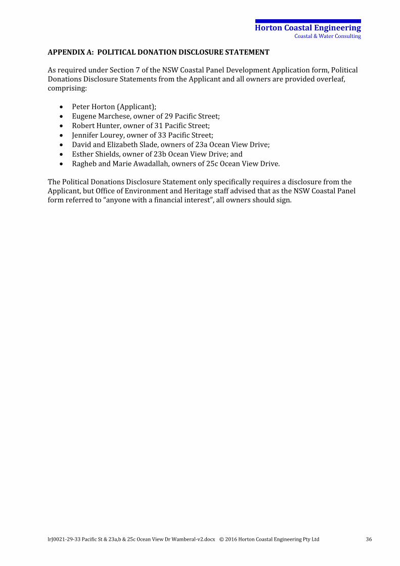
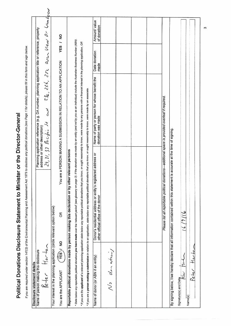
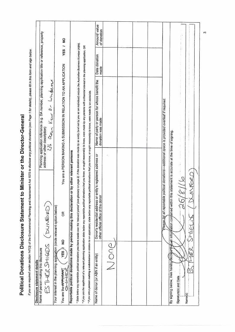
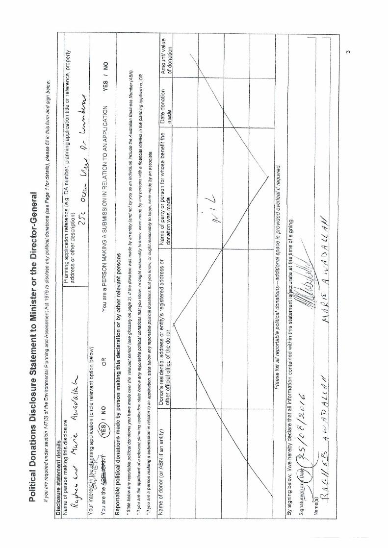
APPENDIX A: POLITICAL DONATION DISCLOSURE STATEMENT
As required under Section 7 of the NSW Coastal Panel Development Application form, Political Donations Disclosure Statements from the Applicant and all owners are provided overleaf, comprising:
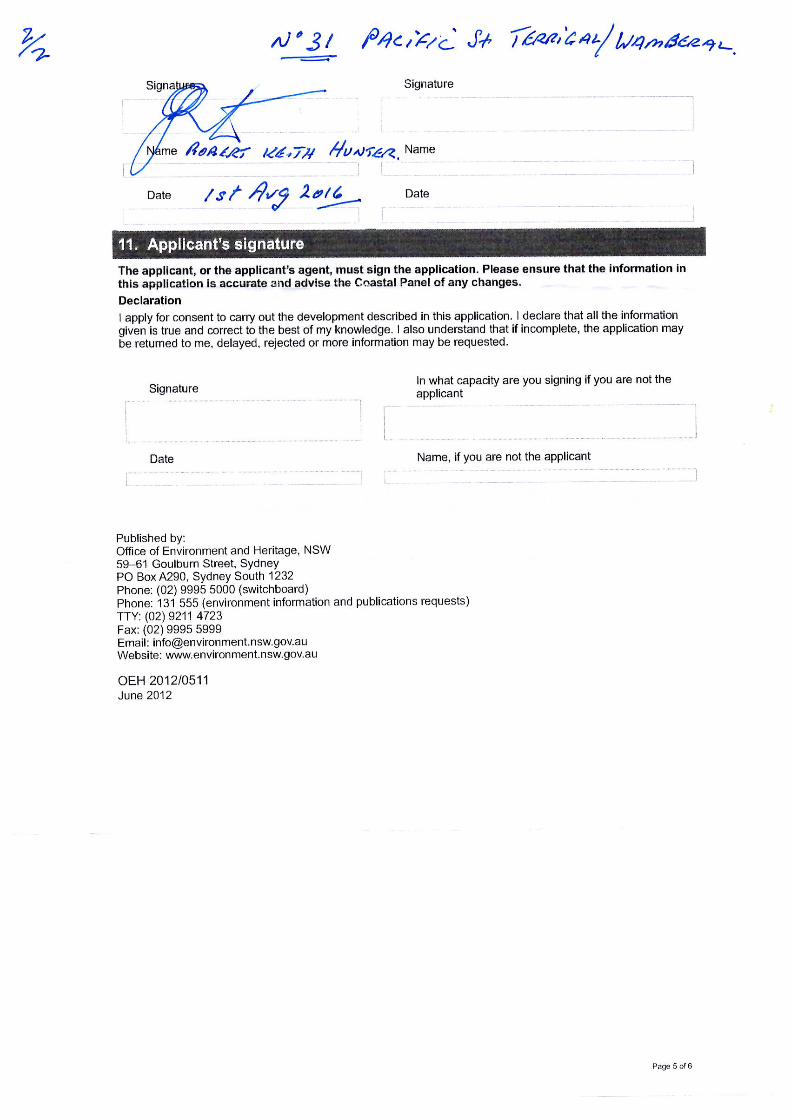
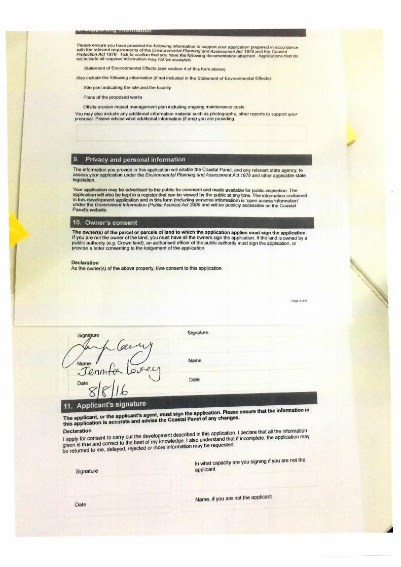
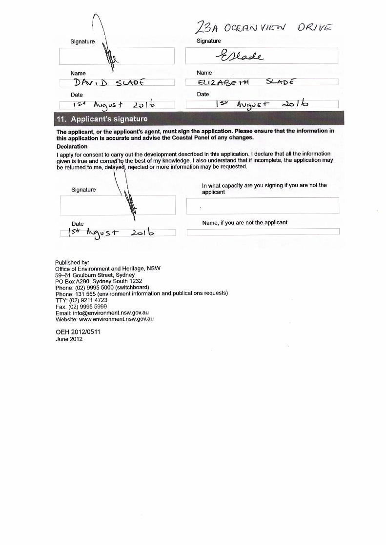
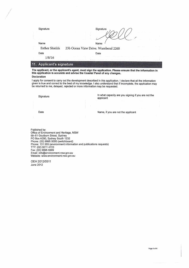
Peter Horton (Applicant); Eugene Marchese, owner of 29 Pacific Street; Robert Hunter, owner of 31 Pacific Street; Jennifer Lourey, owner of 33 Pacific Street; David and Elizabeth Slade, owners of 23a Ocean View Drive; Esther Shields, owner of 23b Ocean View Drive; and Ragheb and Marie Awadallah, owners of 25c Ocean View Drive.
The Political Donations Disclosure Statement only specifically requires a disclosure from the Applicant, but Office of Environment and Heritage staff advised that as the NSW Coastal Panel form referred to “anyone with a financial interest”, all owners should sign.
lrJ0021-29-33 Pacific St & 23a,b & 25c Ocean View Dr Wamberal-v2.docx © 2016 Horton Coastal Engineering Pty Ltd 34
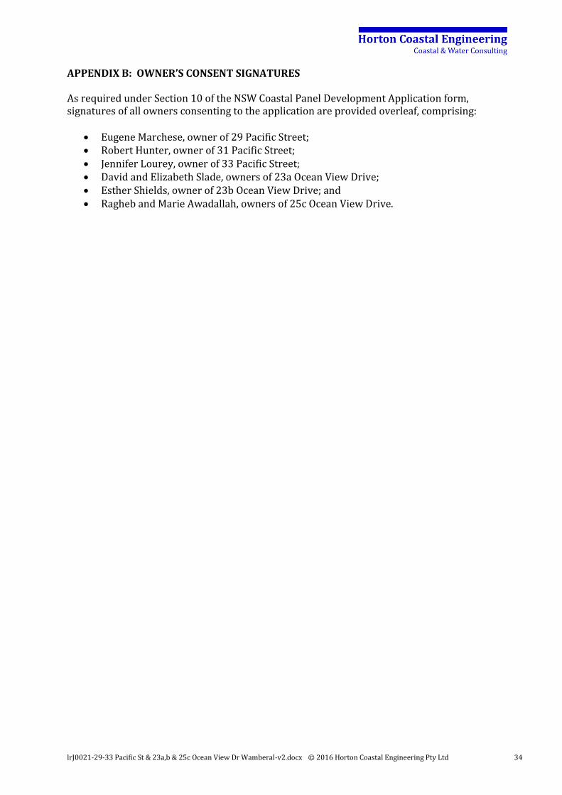
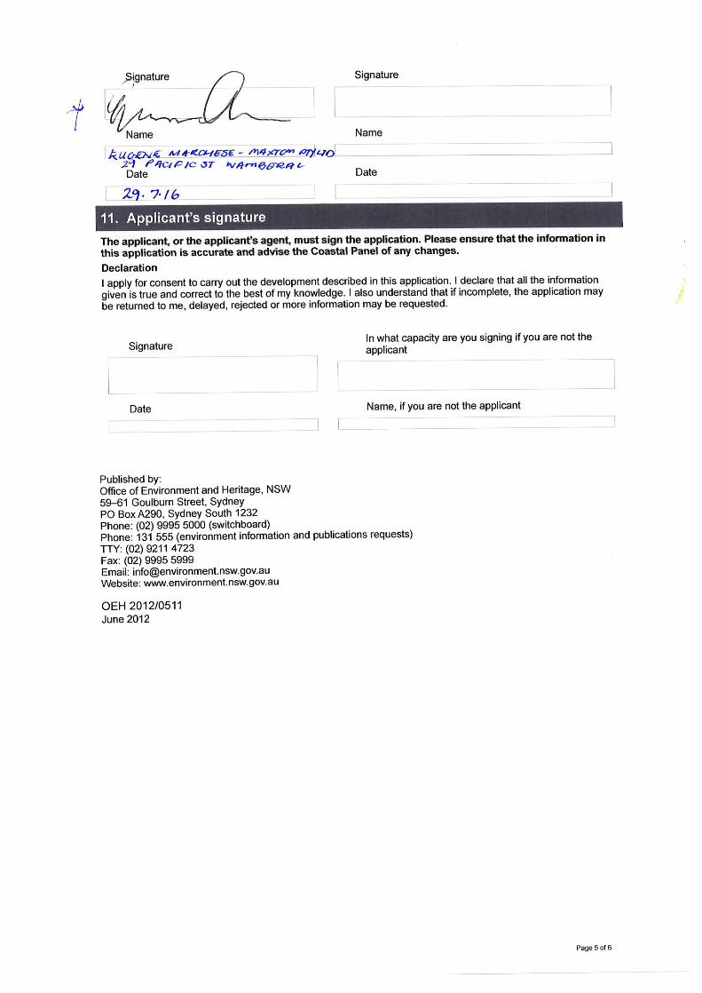
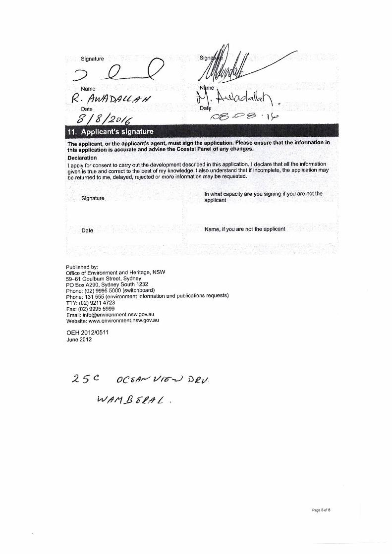
APPENDIX B: OWNER’S CONSENT SIGNATURES
As required under Section 10 of the NSW Coastal Panel Development Application form, signatures of all owners consenting to the application are provided overleaf, comprising:
Eugene Marchese, owner of 29 Pacific Street; Robert Hunter, owner of 31 Pacific Street; Jennifer Lourey, owner of 33 Pacific Street; David and Elizabeth Slade, owners of 23a Ocean View Drive; Esther Shields, owner of 23b Ocean View Drive; and Ragheb and Marie Awadallah, owners of 25c Ocean View Drive.
lrJ0021-29-33 Pacific St & 23a,b & 25c Ocean View Dr Wamberal-v2.docx © 2016 Horton Coastal Engineering Pty Ltd 41
APPENDIX C: DRAWINGS OF PROPOSED WORKS
The proposed rock revetment works are described in plan and cross sections at each property on the Drawings C1.01, C1.02 and C1.03 provided overleaf.
C
1
.0
2
1
C
1
.0
2
1
C
1
.0
2
2
C
1
.0
2
3
C
1
.0
2
3
C
1
.0
2
4
C
1
.0
2
4
C
1
.0
3
5
C
1
.0
3
5
C
1
.0
3
6
C
1
.0
3
6
C
1
.0
2
2
DESCRIPTIONREVISION DATE BY
PROJECT
CLIENT
CHECKEDDRAWNSCALE DATE
DRAWINGJOB
REVISION
DRAWING TITLE
AUGUST 2016
16073 (MP)
& 25C OCEAN VIEW DRIVE, WAMBERAL
29, 31 & 33 PACIFIC ST & 23A, 23B
PROPOSED REVETMENT WORKS AT
OCEAN VIEW DRIVE , WAMBERAL
PACIFIC ST & 23A, 23B & 25C
OWNERS OF 29, 31 & 33
PRELIMINARY
NOT FOR CONSTRUCTION
J0021(HC)
HORTON COASTAL ENGINEERING PTY LTD
18 Reynolds Cres. Beacon Hill NSW 2100
+61 (0)407 012 538
www.hortoncoastal.com.au
COASTAL ENGINEERING DESIGN:
DRAFTING:
A 2016.08.25 ISSUE FOR APPROVAL LB
SITE PLAN
LB PS /PH
AC1.01
1:500@A3
EXTEND WORKS NORTH OF 25COCEAN VIEW DRIVE TO ENSUREADEQUATE TRANSITION TOUNPROTECTED AREAS TO THENORTH
PROPERTY BOUNDARY TOE OF REVETMENTREFER NOTE 7
LEGEND:
TOR - TOP OF REVETMENT
TOR
6.00
TOR
6.00
TOR
5.50
- PROPOSED REVETMENT WORKS
"THE RUINS"
( OWNED BY DEPARTMENT OF PLANNING AND ENVIRONMENT )
#25
WAMBERAL BEACH (CROWN LAND)
0 1 2 3 104 5
TOR
5.50
1. BASE PLAN DERIVED FROM CLARKE DOWDLE & ASSOCIATES SURVEY DATED 24 JUNE 2016, “LOTS 2, 3, 4, 5 & 6 IN DP 8854, LOT 4 IN DP 524938, PLAN SHOWING SPOT LEVELS, CONTOURS & DETAIL”, REFERENCE 20265
2. PRIMARY ARMOUR ROCK TO BE BASALT OR OTHER SUITABLE IGNEOUS ROCK, WITH A MASS IN THE RANGE FROM 2.9 TONNES TO 4.8 TONNES, AND 50% OF ROCKS EXCEEDING A MASS OF 3.8 TONNES
3. SECONDARY ARMOUR ROCK TO BE BASALT OR OTHER SUITABLE IGNEOUS ROCK, WITH A MASS IN THE RANGE FROM 270KG TO 500KG, AND 50% OF ROCKS EXCEEDING A MASS OF 380KG
4. GEOTEXTILE FABRIC TO BE NON-WOVEN NEEDLE PUNCHED STABLE FIBRE, SUITABLE FOR THE MARINE ENVIRONMENT5. ADJACENT GEOTEXTILE STRIPS TO EITHER BE PHYSICALLY JOINED (STITCHED) OR LAPPED BY A MINIMUM OF 1.0M6. CREST LEVEL OF REVETMENT TO BE A MINIMUM AS NOTED ON PLAN OR ADJUSTED TO SUIT ADJACENT LAND LEVELS TO SATISFACTION OF COASTAL ENGINEER7. TOE POSITION OF REVETMENT IS AS PER “DESIGN STUDY FOR WAMBERAL BEACH TERMINAL PROTECTIVE STRUCTURE” PREPARED BY WRL IN 1998 AND ADOPTED IN THE “WAMBERAL BEACH AND PROPERTY PROTECTION ENVIRONMENTAL IMPACT STATEMENT” PREPARED BY MHL IN 2003
8. ALL ELEVATIONS ARE TO AUSTRALIAN HEIGHT DATUM (AHD)
NOTES:
TIE NEW PROTECTION WORKS INTOEXISTING 25 PACIFIC STREET
PROTECTION WORKS (THAT JUSTEXTEND ON TO NO. 29) TO
SATISFACTION OF COASTAL ENGINEER,WITHOUT ADVERSELY IMPACTING ON
THOSE WORKS
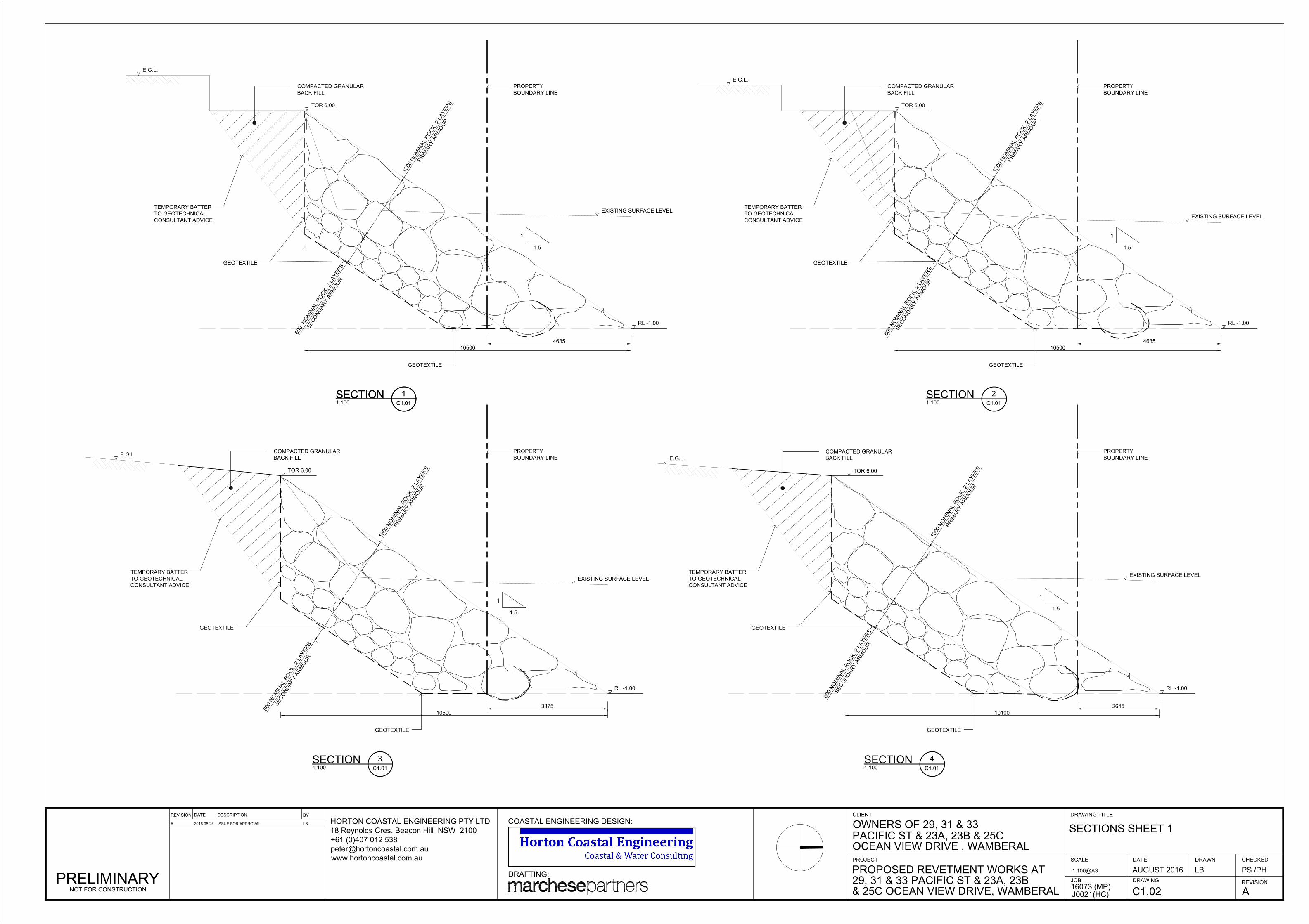
1:100
SECTION
1
C1.01
1
1.5
GEOTEXTILE
COMPACTED GRANULAR
BACK FILL
TOR 6.00
TEMPORARY BATTER
TO GEOTECHNICAL
CONSULTANT ADVICE
GEOTEXTILE
EXISTING SURFACE LEVEL
1:100
SECTION
2
C1.01
10500
1
1.5
GEOTEXTILE
COMPACTED GRANULAR
BACK FILL
TOR 6.00
E.G.L.
TEMPORARY BATTER
TO GEOTECHNICAL
CONSULTANT ADVICE
GEOTEXTILE
EXISTING SURFACE LEVEL
1:100
SECTION
3
C1.01
10500
1
1.5
GEOTEXTILE
COMPACTED GRANULAR
BACK FILL
TOR 6.00
E.G.L.
TEMPORARY BATTER
TO GEOTECHNICAL
CONSULTANT ADVICE
GEOTEXTILE
EXISTING SURFACE LEVEL
1:100
SECTION
4
C1.01
10100
RL -1.00
RL -1.00RL -1.00
1
3
0
0
N
O
M
I
N
A
L
R
O
C
K
,
2
L
A
Y
E
R
S
P
R
I
M
A
R
Y
A
R
M
O
U
R
6
0
0
N
O
M
I
N
A
L
R
O
C
K
,
2
L
A
Y
E
R
S
S
E
C
O
N
D
A
R
Y
A
R
M
O
U
R
6
0
0
N
O
M
I
N
A
L
R
O
C
K
,
2
L
A
Y
E
R
S
S
E
C
O
N
D
A
R
Y
A
R
M
O
U
R
1
3
0
0
N
O
M
I
N
A
L
R
O
C
K
,
2
L
A
Y
E
R
S
P
R
I
M
A
R
Y
A
R
M
O
U
R
6
0
0
N
O
M
I
N
A
L
R
O
C
K
,
2
L
A
Y
E
R
S
S
E
C
O
N
D
A
R
Y
A
R
M
O
U
R
E.G.L.
3875 2645
4635
PROPERTY
BOUNDARY LINE
PROPERTY
BOUNDARY LINE
PROPERTY
BOUNDARY LINE
1
1.5
GEOTEXTILE
COMPACTED GRANULAR
BACK FILL
PROPERTY
BOUNDARY LINE
1
3
0
0
N
O
M
I
N
A
L
R
O
C
K
,
2
L
A
Y
E
R
S
P
R
I
M
A
R
Y
A
R
M
O
U
R
6
0
0
N
O
M
I
N
A
L
R
O
C
K
,
2
L
A
Y
E
R
S
S
E
C
O
N
D
A
R
Y
A
R
M
O
U
R
TOR 6.00
E.G.L.
TEMPORARY BATTER
TO GEOTECHNICAL
CONSULTANT ADVICE
GEOTEXTILE
EXISTING SURFACE LEVEL
SECTION
1
C1.01
10500
RL -1.00
4635
1
3
0
0
N
O
M
I
N
A
L
R
O
C
K
,
2
L
A
Y
E
R
S
P
R
I
M
A
R
Y
A
R
M
O
U
R
DESCRIPTIONREVISION DATE BY
PROJECT
CLIENT
CHECKEDDRAWNSCALE DATE
DRAWINGJOB
REVISION
DRAWING TITLE
AUGUST 2016
16073 (MP)
& 25C OCEAN VIEW DRIVE, WAMBERAL
29, 31 & 33 PACIFIC ST & 23A, 23B
PROPOSED REVETMENT WORKS AT
OCEAN VIEW DRIVE , WAMBERAL
PACIFIC ST & 23A, 23B & 25C
OWNERS OF 29, 31 & 33
PRELIMINARY
NOT FOR CONSTRUCTION
J0021(HC)
HORTON COASTAL ENGINEERING PTY LTD
18 Reynolds Cres. Beacon Hill NSW 2100
+61 (0)407 012 538
www.hortoncoastal.com.au
COASTAL ENGINEERING DESIGN:
DRAFTING:
A 2016.08.25 ISSUE FOR APPROVAL LB
SECTIONS SHEET 1
LB PS /PH
AC1.02
1:100@A3
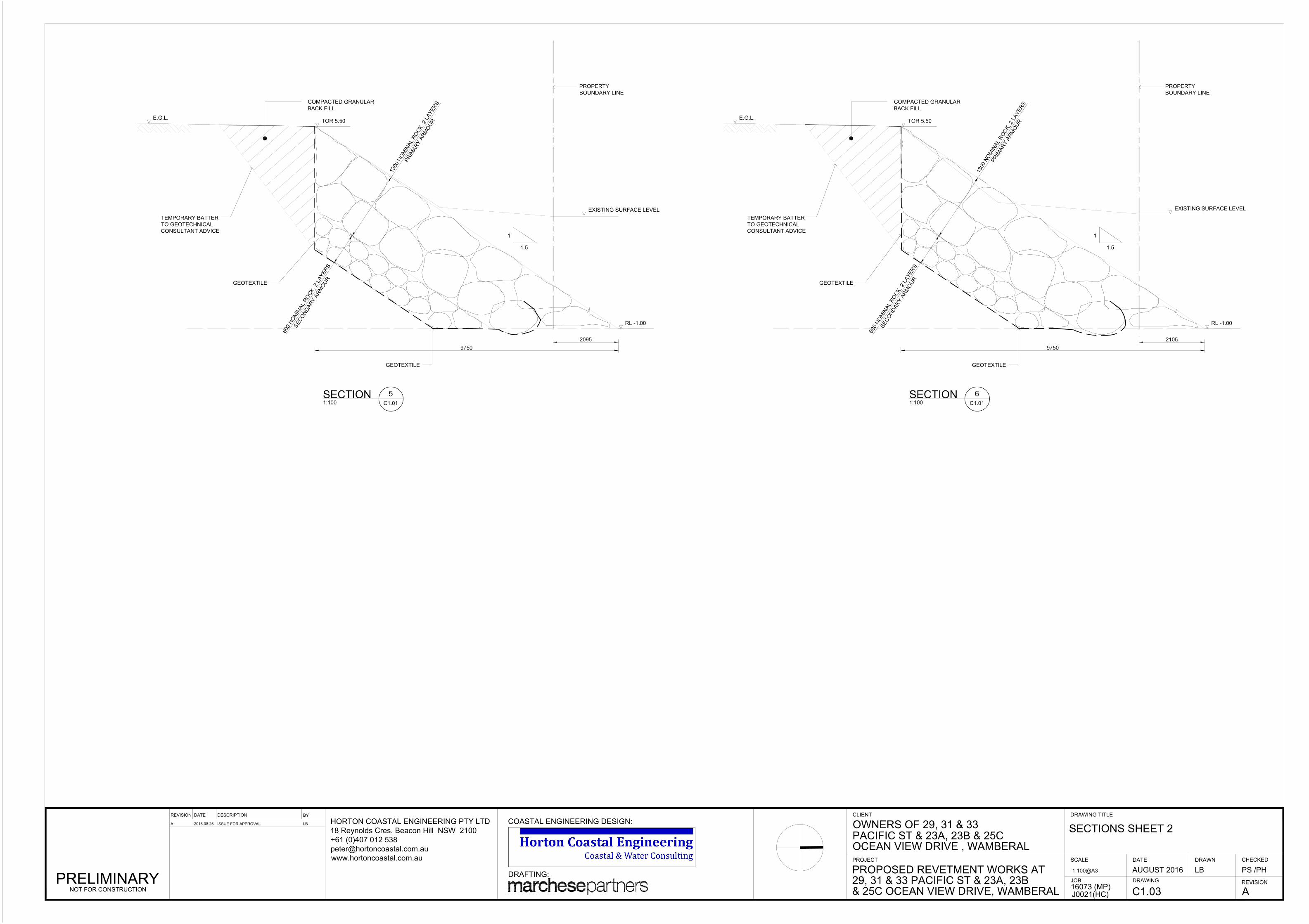
1
1.5
GEOTEXTILE
COMPACTED GRANULAR
BACK FILL
TOR 5.50
E.G.L.
TEMPORARY BATTER
TO GEOTECHNICAL
CONSULTANT ADVICE
GEOTEXTILE
EXISTING SURFACE LEVEL
1:100
SECTION
5
C1.01
9750
1
1.5
GEOTEXTILE
COMPACTED GRANULAR
BACK FILL
TOR 5.50
TEMPORARY BATTER
TO GEOTECHNICAL
CONSULTANT ADVICE
GEOTEXTILE
EXISTING SURFACE LEVEL
1:100
SECTION
6
C1.01
9750
RL -1.00 RL -1.00
1
3
0
0
N
O
M
I
N
A
L
R
O
C
K
,
2
L
A
Y
E
R
S
P
R
I
M
A
R
Y
A
R
M
O
U
R
6
0
0
N
O
M
I
N
A
L
R
O
C
K
,
2
L
A
Y
E
R
S
S
E
C
O
N
D
A
R
Y
A
R
M
O
U
R
1
3
0
0
N
O
M
I
N
A
L
R
O
C
K
,
2
L
A
Y
E
R
S
P
R
I
M
A
R
Y
A
R
M
O
U
R
6
0
0
N
O
M
I
N
A
L
R
O
C
K
,
2
L
A
Y
E
R
S
S
E
C
O
N
D
A
R
Y
A
R
M
O
U
R
2095 2105
E.G.L.
PROPERTY
BOUNDARY LINE
PROPERTY
BOUNDARY LINE
DESCRIPTIONREVISION DATE BY
PROJECT
CLIENT
CHECKEDDRAWNSCALE DATE
DRAWINGJOB
REVISION
DRAWING TITLE
AUGUST 2016
16073 (MP)
& 25C OCEAN VIEW DRIVE, WAMBERAL
29, 31 & 33 PACIFIC ST & 23A, 23B
PROPOSED REVETMENT WORKS AT
OCEAN VIEW DRIVE , WAMBERAL
PACIFIC ST & 23A, 23B & 25C
OWNERS OF 29, 31 & 33
PRELIMINARY
NOT FOR CONSTRUCTION
J0021(HC)
HORTON COASTAL ENGINEERING PTY LTD
18 Reynolds Cres. Beacon Hill NSW 2100
+61 (0)407 012 538
www.hortoncoastal.com.au
COASTAL ENGINEERING DESIGN:
DRAFTING:
A 2016.08.25 ISSUE FOR APPROVAL LB
SECTIONS SHEET 2
LB PS /PH
AC1.03
1:100@A3
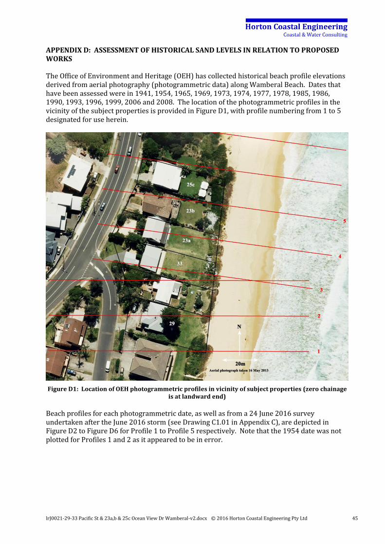
lrJ0021-29-33 Pacific St & 23a,b & 25c Ocean View Dr Wamberal-v2.docx © 2016 Horton Coastal Engineering Pty Ltd 45
APPENDIX D: ASSESSMENT OF HISTORICAL SAND LEVELS IN RELATION TO PROPOSED WORKS
The Office of Environment and Heritage (OEH) has collected historical beach profile elevations derived from aerial photography (photogrammetric data) along Wamberal Beach. Dates that have been assessed were in 1941, 1954, 1965, 1969, 1973, 1974, 1977, 1978, 1985, 1986, 1990, 1993, 1996, 1999, 2006 and 2008. The location of the photogrammetric profiles in the vicinity of the subject properties is provided in Figure D1, with profile numbering from 1 to 5 designated for use herein.
Figure D1: Location of OEH photogrammetric profiles in vicinity of subject properties (zero chainage is at landward end)
Beach profiles for each photogrammetric date, as well as from a 24 June 2016 survey undertaken after the June 2016 storm (see Drawing C1.01 in Appendix C), are depicted in Figure D2 to Figure D6 for Profile 1 to Profile 5 respectively. Note that the 1954 date was not plotted for Profiles 1 and 2 as it appeared to be in error.
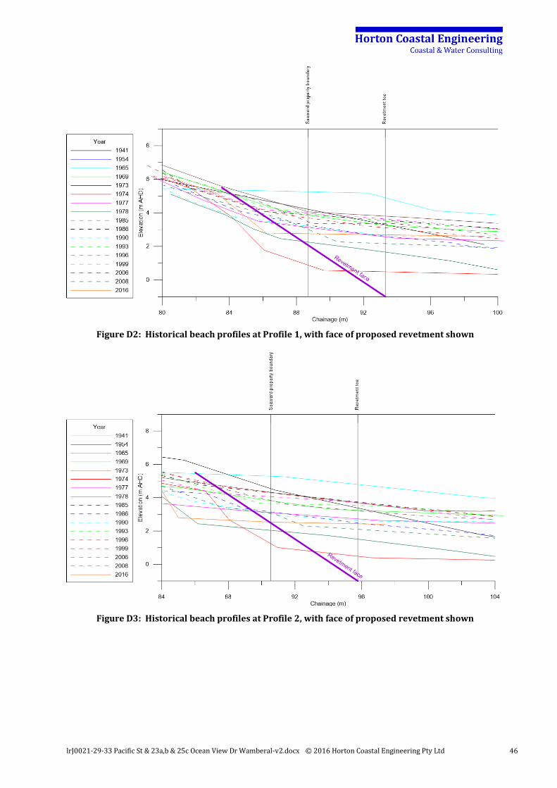
lrJ0021-29-33 Pacific St & 23a,b & 25c Ocean View Dr Wamberal-v2.docx © 2016 Horton Coastal Engineering Pty Ltd 46
Figure D2: Historical beach profiles at Profile 1, with face of proposed revetment shown
Figure D3: Historical beach profiles at Profile 2, with face of proposed revetment shown
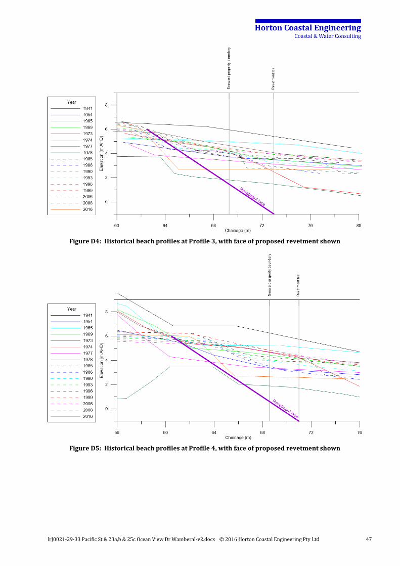
lrJ0021-29-33 Pacific St & 23a,b & 25c Ocean View Dr Wamberal-v2.docx © 2016 Horton Coastal Engineering Pty Ltd 47
Figure D4: Historical beach profiles at Profile 3, with face of proposed revetment shown
Figure D5: Historical beach profiles at Profile 4, with face of proposed revetment shown
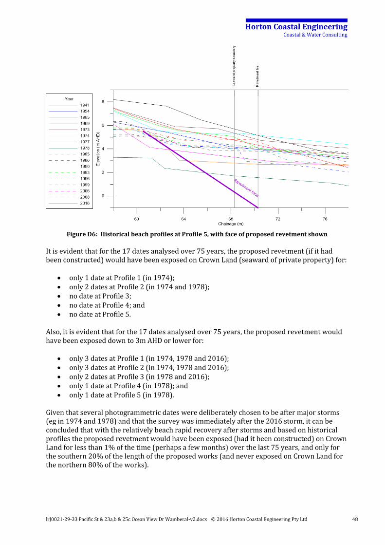
lrJ0021-29-33 Pacific St & 23a,b & 25c Ocean View Dr Wamberal-v2.docx © 2016 Horton Coastal Engineering Pty Ltd 48
Figure D6: Historical beach profiles at Profile 5, with face of proposed revetment shown
It is evident that for the 17 dates analysed over 75 years, the proposed revetment (if it had been constructed) would have been exposed on Crown Land (seaward of private property) for:
only 1 date at Profile 1 (in 1974); only 2 dates at Profile 2 (in 1974 and 1978); no date at Profile 3; no date at Profile 4; and no date at Profile 5.
Also, it is evident that for the 17 dates analysed over 75 years, the proposed revetment would have been exposed down to 3m AHD or lower for:
only 3 dates at Profile 1 (in 1974, 1978 and 2016); only 3 dates at Profile 2 (in 1974, 1978 and 2016); only 2 dates at Profile 3 (in 1978 and 2016); only 1 date at Profile 4 (in 1978); and only 1 date at Profile 5 (in 1978).
Given that several photogrammetric dates were deliberately chosen to be after major storms (eg in 1974 and 1978) and that the survey was immediately after the 2016 storm, it can be concluded that with the relatively beach rapid recovery after storms and based on historical profiles the proposed revetment would have been exposed (had it been constructed) on Crown Land for less than 1% of the time (perhaps a few months) over the last 75 years, and only for the southern 20% of the length of the proposed works (and never exposed on Crown Land for the northern 80% of the works).
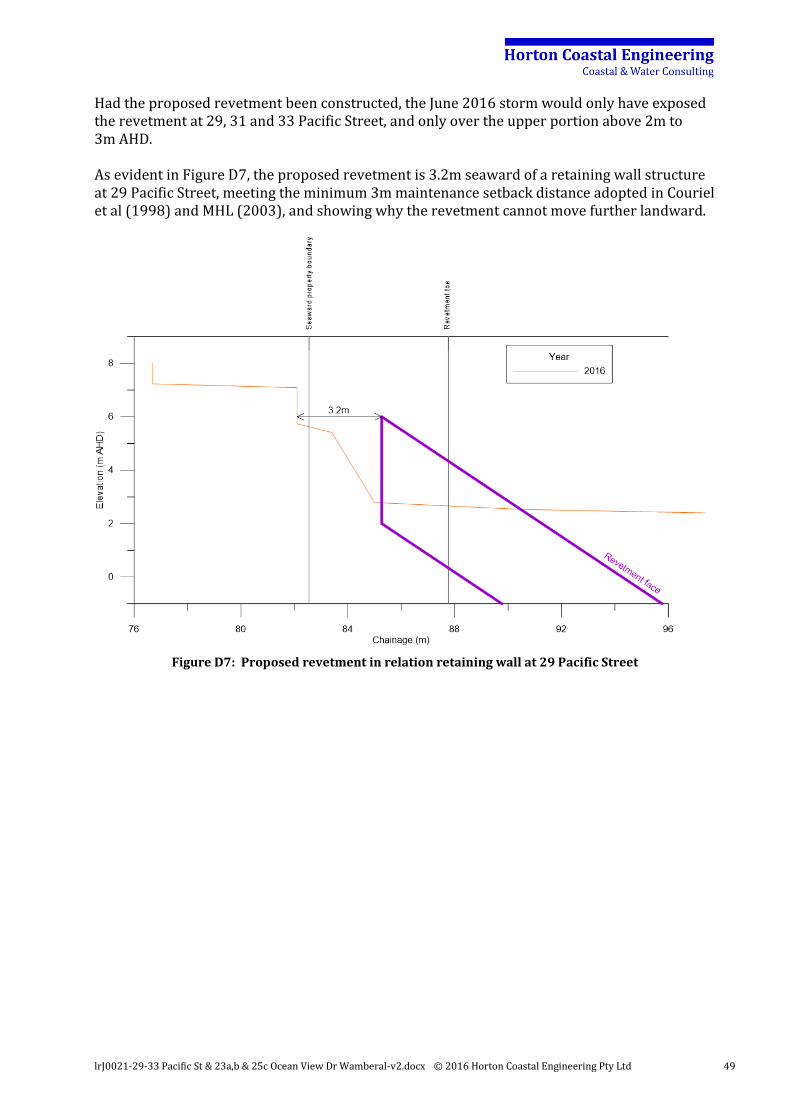
lrJ0021-29-33 Pacific St & 23a,b & 25c Ocean View Dr Wamberal-v2.docx © 2016 Horton Coastal Engineering Pty Ltd 49
Had the proposed revetment been constructed, the June 2016 storm would only have exposed the revetment at 29, 31 and 33 Pacific Street, and only over the upper portion above 2m to 3m AHD. As evident in Figure D7, the proposed revetment is 3.2m seaward of a retaining wall structure at 29 Pacific Street, meeting the minimum 3m maintenance setback distance adopted in Couriel et al (1998) and MHL (2003), and showing why the revetment cannot move further landward.
Figure D7: Proposed revetment in relation retaining wall at 29 Pacific Street