Embed Size (px)
Citation preview


THE UNIVERSITY OF HONG KONGLIBRARIES
Hong Kong Collection

TOWN PLANNING
IN
HONG KONG
Town Planning DivisionLands DepartmentMurray Building
Hong Kong1984

Printed by the Government Printer, Hong Kong

CONTENTS
Page1. MAJOR LOCAL PLANNING ISSUES
Introduction 7
Location and Physical Setting 7
Land Resources 7
Population 8
Housing 9
Transportation 10
Summary 11
2. HISTORY OF TOWN PLANNING
Introduction 12
Enactment of Town Planning Ordinance 12
The Abercrombie Report 12
Planning Achievements: 1953-1973 12
Planning From 1973 Onwards 13
3. PLANNING ORGANIZATION AND RESPONSIBILITIES
Structure of the Government 14
Organization and Functions of the Town Planning Division 14
Planning Functions of the New Territories Development Department 15
Planning Functions of the Urban Area Development Organization 15
Planning Functions of the Strategic Planning Unit 16
4. HIERARCHY OF PLANS
Introduction 17
Territorial Plans 17
Hong Kong Planning Standards and Guidelines 17
Territorial Development Strategy 18
Sub-Regional Plans • 19
Structure Plans 19
District/Local Plans 19
Statutory Outline Zoning Plans 19
Outline Development Plans 20
Layout Plans 20
Public Access to Plans f 21
Page5. DEVELOPMENT CONTROL AND PRACTICE
Introduction 22
Development Control in a Regional Context 22
Statutory Control 22
Town Planning Ordinance 22
Buildings Ordinance 23
Crown Lease Conditions 23
Hong Kong Airport (Control of Obstructions) Ordinance 24
Non-Statutory Control 24
Density Zoning 24
Areas of Special Control 24
Other Special Control Measures 25
6. NEW TOWN DEVELOPMENT
Why is New Town Development Necessary 26
Objectives of Building New Towns 26
Development Concepts 26
The Planning and Implementation Process 27
General Review 27
7. URBAN RENEWAL
The Need for Urban Renewal in the Main Urban Areas 28
Goal and Objectives 28
Government's Past Effort 28
Effort Prior to the Sixties • 28
Urban Renewal in the Sixties 28
Pilot Scheme Area 28
Renewal Effort in the Seventies 29
Environmental Improvement Area 29
Comprehensive Redevelopment Area 29
Urban Improvement Scheme 29
Difficulties Encountered 29
Current Studies and Future Outlook 30
EPILOGUE 31
APPENDIX: ILLUSTRATIONS 33
AT
Diagram Description
1.1 Location of Hong Kong
1.2 Location of New Towns and Relief of Hong Kong
1.3 Hong Kong Harbour—Stages of Reclamation
1.4 Squatter Area off Shau Kei Wan Road
1.5 Transportation System in Hong Kong
3.1 Organization Structure of the Hong Kong Government Directly Involved in Land Use Planning
3.2 Town Planning Division: Organization Chart
3.3 New Territories Development Department: Organization Chart
3.4 Urban Area Development Organization: Organization Chart
4.1 The Hierarchy of Plans
4.2 Planning Standards Sub-Committee Outline of Procedures
4.3 Mock Up Structure Plan for North East New Territories
4.4 Boundaries of Sub-Regional Divisions
4.5 An Example of Outline Zoning Plan—Wan Chai Outline Zoning Plan
4.6 Major Steps in the Preparation of Statutory Plans
4.7 An Example of Outline Development Plans—Wan Chai Outline Development Plan
4.8 An Example of Layout Plan—Wan Chai Layout Plan
5.1 Reservoirs and Gathering Grounds
5.2 Hong Kong Country Parks
5.3 (a) Density Zoning—Hong Kong Island
(b) Density Zoning—Kowloon and New Kowloon
5.4 Development Control—Authorities and Control Measures
6.1 Population Distribution and Housing Mix of New Towns
6.2 Sha Tin Outline Zoning Plan
7.1 Urban Renewal District Pilot Scheme Area—Layout Plan
7.2 (a) ; Sheung Wan Pilot Scheme Area—1972
(b) Sheung Wan Pilot Scheme Area—1982
7.3 (a) Urban Renewal in Main Urban Areas—Hong Kong Island
• (b) Urban Renewal in Main Urban Areas—Kowloon and New Kowloon
- • • • ' . • • • " • . • ' . ' • • • "v


ONE
MAJOR LOCAL PLANNING
INTRODUCTION
Planning for a city such as Hong Kong is an enormous challenge. Fraught with seemingly unsolvable problems,planning policy and programmes have aimed to respond positively and energetically to ameliorate these problems.
Local planning has had to cope with essentially two major problems: the critical shortage of developable landcoupled with a high population growth rate particularly caused by immigration in recent years. The interplay of theseproblems have resulted in the rapid and intensive development of Hong Kong, making it one of the most denselypopulated cities in the world. In efforts to solve these problems, the Government has initiated land reclamation pro-grammes adding 1.7% additional developable land since 1945. The Government has also undertaken a massive publichousing programme and established a new town programme in the 1970's with the aim of providing a 'balanced'community while relocating urban populations into better housing and living conditions. Furthermore, a comprehen-sive approach to handling the transportation system via mass and public transit while restraining private car ownershipwas adopted. This chapter attempts to review the scale and scope of these issues and the planning efforts in response.
LOCATION AND PHYSICAL SETTING
Hong Kong is situated at the mouth of the Pearl River on the south-eastern coast of Mainland China. It is justinside the tropics, less than 160 kilometres south of the Tropic of Cancer, and lies between latitudes 22C9' and22°37/ north and longitudes 113°52' and 114°30' east (Diagram 1.1).
Hong Kong is about 1 066.53 square kilometres in area. It is made up of hundred of islands, with the larger onesbeing Hong Kong Island, Lantau, Tsing Yi, Ap Lei Chau and Lamma.
The urban built up areas include Hong Kong Island, Kowloon and New Kowloon which constitute only about9% of the total land area in the Territory. The remaining 91 % are mostly scrubland, woodland, badland and arableland in the New Territories interspersed between new towns.
Victoria Harbour, which lies between Hong Kong Island and Kowloon Peninsula, is deep and sheltered and isan invaluable asset to Hong Kong.
LAND RESOURCES
Existing Land Use
Of the total land in Hong Kong, only 16% is built up area. The main urban areas of Hong Kong Island, Kowloon, andsix new towns in the New Territories—Tsuen Wan, Tuen Mun, Yuen Long, Fanling/Shek Wu Hui, Tai Po and ShaTin—constitute almost 9% (Diagram 1.2) while the remaining 7% of the built-up land are rural market towns andvillages, with the most prominent being Sai Kung, Ping Shan, Kam Tin, Cheung Chau, Mui Wo, Tai O, Tung Chung etc.
The rest of the Territory is mostly uninhabited, typically grass and scrub land; and badlands (63%). Naturaland established woodlands (11.7%) in Hong Kong are rare. The afforested areas are mainly found in areasadjoining water reservoirs and within country parks.
Most of Hong Kong's arable land lies in the north-western part of the New Territories, with Yuen Long Plainaccounting for the largest amount of arable land. These cultivated areas are used for market gardening. With thecontinuance of urban sprawl, more cultivable land are left fallow.
Despite the decrease in arable land, the acreage offish ponds remains steady at 1.7%. This includes fresh andbrackish water fish farming but excludes coastal marine fish farms. A breakdown of land utilization in Hong Kongin 1983 is found in the following Table 1.1.
Table 1.1 Land Utilization in Hong Kong 1983
Approximate AreaLand Use Classification (square kilometres) Percentage
Urban built-up land 96 9.0Rural developed laiid 74 7.0Woodlands 125 11.7' .Grass and scrub land 624 58.7Badlands 46 4.3Arable 80 7.5Fishponds 18 1.7Swamp and mangroves 1 0.1
1 064 100.0%
Source: Hong Kong 1983, Government Information Services, Hong Kong, p. 63.

Topography and the Shortage of LandGenerally, the landform of Hong Kong is rugged. About 80 per cent of the Territory consists of hilly land. Thesehills form the backbone of the terrain with the highest point at 958 metres on Tai Mo Shan. Series of ridges extendto the north-east (Pat Sin Range), south-west (Lantau Peak and Sunset Peak) and the west (Tai Lam Chungareas). The only extensive area of flatland is in the north-western part of the New Territories. Some of the coastalareas are still affected by flood during heavy rainfall particularly at high tides, making development of these areasmore costly.
The majority of the developable areas are found north and south of Victoria Harbour where urban developmentconcentrates on the narrow strip of coastal land extending from west to east. The presence of steep slopes, coupledwith the large population, accounts for the very high concentration of people in the developed areas. Withincreasing pressure on land and limited developable area, there is an increasing tendency for uphill developmentin the city. More and more highrise towers are now standing on the very steep slopes of the Victoria Peak.Through the use of modern engineering technology slopes are levelled, making the steepest slopes safe to buildon at extra cost.
Creation of Land Through ReclamationThe shortage of land has long been the cause of high density development and overcrowdedness in Hong Kong.Through levelling of hills and reclamation, new land has been created for urban development.
Schemes existed for moderate reclamation at least as far back as 1855. Gaining land from the sea has continuedto keep pace with accelerating rates of urban development. Since the end of the 19th Century strips of land hasbeen added onto the coast along Victoria Harbour through different stages of reclamation (Diagram 1.3). Butslowly they have extended to the coastal regions in the New Territories especially after the Second World War.Larger reclamation areas in the New Territories include Gin Drinker's Bay, Tide Cove, Tolo Harbour and morerecently, Ma On Shan, Tuen Mun and Junk Bay. The total area of land created through reclamation during theperiod 1945-1983 is 1 787.6 hectares, amounting to approximately 1.7% of the total land area in Hong Kongin 1983.
In general, most reclamations are intensively used for housing development. Public housing developments onreclaimed land are found at Kwun Tong, Wah Fu, Chai Wan etc. Private housing development are found atLai Chi Kok (Mei Foo Sun Chuen) and Quarry Bay (Taikoo Shing) etc. Other reclaimed areas are heavilycommitted as commercial centres (Central and Wan Chai) and industrial sites (Container Terminal at KwaiChung and industrial estates at Kwun Tong).
The importance of reclamation in creating new land for meeting the housing needs of the city has been reiteratedin the consultant study on 'Harbour Reclamations and Urban Growth' commissioned by the Government in1982. This study serves as part of a programme by the Government to coordinate overall planning, and to meethousing, transportation, employment and other needs of the population. It details the potential for furtherreclamations within the harbour area, and the scope for additional urban land created through the redevelopmentof existing properties and the development of new sites.
POPULATION
Growth: A General OutlookThe total population of Hong Kong had increased dramatically from 3.1 million in 1961 to 5 million in 1981.By the end of 1982 the total population was estimated to be 5 287 800. Table 1.2 shows the population growthsince 1961.
The average annual rate of increase over the last 10 years was 2.4%, fluctuating at changes in migration flows,During the years 1978-1980 in particular, there was a large inflow of immigrants from China—both legal andillegal—and an influx of boat refugees from Vietnam. The average annual growth rate increased from 1.8% overthe period 1972-1977 to 3.9% over the period 1978-1980. The average annual growth rate for the years 1981-1982dropped to 1.6% due to a reduction in the inflow of immigrants as a result of stricter control of illegal immigrantsat the end of 1980. Due to efforts advocating family planning, the rate of natural increase dropped steadily overthe period 1972-1982 from 14 to 12 per thousand.
Table L2 Population Growth Since 1961
Year Total Population*
1961 31296481971 39366301976 44029901981 49865601982 (Estimate) 5287800
* Figures exclude transients, Vietnamese refugees and residents away from Hong Kong on the reference date.Source: Census and Statistics Department.

Density and'Spatial Distribution
With the total population increasing by over a million since 1971, the population density of Hong Kong as awhole reached a peak in 1982, resulting in 4 923 persons per square kilometre as compared with the correspondingfigure of 3 750 eleven years ago. The figure was even higher when individual urban districts were considered.According to the 1981 census, the three census districts with the largest population density, Sham Shui Po,Mong Kok and Hung Horn had a density of 165000, 161 000 and 120000 persons per square kilometrerespectively.
There was a considerable pressure on the demand for land to house the ever increasing population, andit was essential to develop hitherto sparsely populated areas in order to relieve overcrowding in the olddistricts.
A huge development programme in the New Territories started in the 1970's. Out of the largely rural expanse ofthe New Territories the new towns of Tsuen Wan—first developed in the early 1960's—Sha Tin and Tuen Munemerged as self-contained communities providing housing, schools, shopping, community facilities and industry.Meanwhile the old market towns of Tai Po, Sheung Shui/Fanling, and Yuen Long were being expanded,modernized, and provided with additional infra-structure to meet daily needs. A seventh new town in Junk Bay iscurrently being planned. The new town scheme has the objectives of relocating urban populations living at highdensities, providing them with better housing and improved living conditions while at the same time attractingindustry.
Table 1.3 Distribution of Population
Broad Census Area 1961 1971 1981 1961 1971 1981('000) ('000) ('000) % % %
Hong Kong Island 1005 996 1184 32 25 24Kowloon 725 716 799 23 18 16NewKowloon 853 1469 1651 27 37 33New Territories 410 676 1303 13 17 26
New towns N.A. (395)* (939) N.A. (10) (19)Other areas N.A. (280)* (364) N.A. (7) (7)
Marine 137 80 50 4 2 1
Total 3130 3937 4987 100 100 100
Note: Figures may not add up to total due to rounding.* Figures in brackets are detailed breakdowns in the New Territories.Source: Hong Kong 1981 Census, Main Report Volume 1, Census and Statistics Department, Hong Kong, p. 63.
This massive urbanization programme has a significant effect on the geographical distribution of the population.Table 1.3 shows that there was an increase in the number of people moving from the main urban areas of HongKong Island, Kowloon, and New Kowloon to the new towns between 1961 and 1981. As a result of people movingout of the older urban areas, the population in the conurbation of Hong Kong Island, Kowloon and NewKowloon grew at a lower annual rate than that of the whole of Hong Kong. There was even a loss of population ina number of urban districts. Another group that also showed a decline is the marine population.
HOUSING
Demand for Housing
Rapid population increase
The post war natural increase in population and the large influx of legal and illegal immigrants in the 1950s andbetween 1978-80 have resulted a greater demand for housing and extreme overcrowdedness in urban areas.Without permanent accommodation many resorted to squatting. Squatters illegally occupying areas of Crownland have posed a demand for permanent housing. Despite government's huge efforts in public housingdevelopment and the rapid expansion of private housing, there remains squatters who are still on the waiting listfor public housing and who are either unable or unwilling to afford private accommodation. Estimate put thecurrent squatter population at about half a million.
Increase in the number of household
Aggravating the problem was an increase in the number of households at a rate higher than population growth;between 1971-1981 at 3.8% per annum. This was partly due to continuing economic prosperity which enabledyoung people to form their own nuclear families.

Government's Response
Provision for public housing
In 1973 the Ten-Year Housing Programme was launched with the primary aim of overcoming Hong Kong'shousing problems and providing all households with a permanent, self-contained home at an affordable price. Theplan called for a concerted house-building programme intended to supply housing for 1.8 million within amaximum of 10 years. As developable urban land became increasingly scarce, development had to spread to theonce rural New Territories.
Both the Housing Authority established under the Housing Ordinance and the Hong Kong Housing Societyincorporated in 1951 played a very active role in the provision of low-cost housing for low-income families. InMarch 1973, the total number of public housing units, comprising Group A and B Estates, Cottage Areas andHousing Society Estates, was 352 341. In ten years' time, this number grew to about 509 300 units, inclusive ofHousing Authority Estates, Cottage Areas, Housing Society Estates and Home Ownership Scheme Blocksintroduced in early 1976.
In 1983 the annual production target for public housing unit was set at 35 000. The Government has emphasizedthat this rate of production is not the maximum target and when circumstances permit expansion would beconsidered.
Squatter control, clearance and improvement
Due to poor living conditions and illegal occupation of Crown land, squattering has been considered a menace topublic health and land development. The Government has attempted to clear those areas required for permanentdevelopment and to exercise control over the building of additional structures. The main task is to restrict thegrowth of temporary structures on areas of Crown land required for development or where such structures arelikely to create health, fire or structural hazard.
Squatter fires and landslides during 1981 have highlighted the safety and environmental problems in squatterareas. In early 1982, a Squatter Area Improvements Division was established within the Housing Department toundertake the planning of improvements to squatter areas not expected to be cleared for development for sometime. A comprehensive squatter improvement programme is now being implemented providing fire-fightinginstallations, fire-breaks, basic services such as sanitation, drainage, water and electricity, as well as amenities suchas sitting-out areas. Nevertheless, it is envisaged that about half of the families living in squatter areas will berehoused within the next five years.
TRANSPORTATION
General Review
Rapid and dense urban development, the growth of new towns and sustained economic activity have all posed aheavy burden on Hong Kong's internal transport system. In general, urban transportation in Hong Kong ischaracterized by its low car-ownership ratio, as compared to other developed countries, limited road capacityand dependence on public transport.
Between 1966 and 1982 there was an increase of 29.4% of road space from approximately 948 km to 1 227 km.The registration of motor vehicles of all types over the same period more than tripled from 93 000 to over 330 000.This meant an average of 276.6 vehicles for every kilometre of road space. As for the registration of private cars,there was quite a substantial increase during the same period, from approximately 57 000 in 1966 to 215 000 in1982. However, due to. government policies (discussed in the following) there has been a decline in the growthrate of private car registration since 1982. In January 1984, the registration of private cars dropped toapproximately 199 800. At the end of 1982 when the peak of car ownership was reached, it was estimated that24.6% households in Hong Kong owned a motor car.
By the same token, over 75% of households today rely on public transport. This dependence on public transportis of concern as a growing proportion of population is living at an increasing distance from the centres of economicand social activity as a result of urban growth and development of the New Territories. Statistics showed that over94% of the work trips and 92% of the school trips by mechanical modes were made on public transport in 1976.
Major Transport Study and Government's PolicyIn 1973, The Hong Kong Comprehensive Transport Study' was commissioned by the Government to:
• establish the requirements of a transportation system in which thedemand for movement and the facilities available to meet that demandwould be balanced to the greatest possible extent;
• examine the transport mix necessary to reach this balance and themethods by which it may be achieved in practice;
• examine the effect on transportation system of changes in populationprediction and distribution and of road construction and mass transitconstruction programmes; and
® examine the effect of certain stated transportation policies.
' • • . . ' . ' ' ' ' ' , . " ' ' . ' • ' . ' . 1 0 • • • ; : ' • . • • ' • - ' • ' ' • : . . ' ' ' ' . • ,

It recommended a high road investment programme, an extended and early completion of the full mass transitsystem, reconstruction of the Kowloon-Canton Railway and progressive fiscal constraint on private cars.
In 1979 the White Paper on Internal Transport Policy was published. Proposals included:• improvement of road system;• expansion and improvement of public transport; and• a more economic use of the road system.
Further to the publication of the White Paper, action has been taken by the Government to improve the roadsystem. Several major road improvement projects were completed and work on the New Territories trunk road,the New Territories Circular Road and the Island Eastern Corridor progressed satisfactorily.
To increase mass transport capacity, the modified initial system of the MTR was completed in 1981 and thework on MTR Island Line is now in full swing. The electrification of the entire Kowloon-Canton Railwaybetween Hung Horn and Lo Wu was completed in 1983. Should the Light Rail Transit be built in Tuen Mun,mass transport capacity of western New Territories will be further increased.
To tackle congestion on roads, measures have been taken to restrain the growth rate of private cars andmotor-cycles. These measures included doubling the rate of first registration tax, tripling the annual private vehiclelicence fees, substantially raising the duty on petrol and the electronic road pricing system, feasibility of which iscurrently under consideration. As a result, the number of new private cars registered between May and December1982 dropped by 66% compared with the same period in 1981. It is hoped that these measures will keep the growthrate of private cars down from the level of 11% in 1981 to the new policy target of not more than 5% per annum.
SUMMARYThis chapter has highlighted some of the major planning issues which Hong Kong has been facing and willprobably continue to face. These planning issues may be quite different to those of other cities—our resources aremuch limited, land extremely short, pace of change remarkably rapid, density higher, etc. Together with manyother cultural, historical and political factors, they all constitute a very different context of planning in HongKong.
In the following chapters, discussions will focus on how planning is carried out in Hong Kong, its pastachievements and outlook for the future.
11

TWO
OF TOWN PLANNING
INTRODUCTIONSimilar to many other countries, the Government plays a very active role in the planning and development ofHong Kong. The evolution of town planning in Hong Kong has occurred in concert with the emergence of aformal planning body institutionalized within the Government.
ENACTMENT OF TOWN PLANNING ORDINANCEThe earliest history of institutionalized planning essentially began with the enactment of the Town PlanningOrdinance in 1939- It was in this Ordinance that the aim 'to promote the health, safety, convenience and generalwelfare of the community' was first proclaimed. Under the provisions of the Ordinance, the Town Planning Boardwas appointed by the Governor to prepare draft plans for the future layout of existing and potential urban areas asdirected. Owing to the interruption of the Second World War the first meeting of the Board was only convenedin 1951. ^
THE ABERCROMBIE REPORTIn 1947, Sir Patrick-Abercrpmbie was appointed to advise the Governor of Hong Kong on the general lines andprinciples to be followed in planning the future development of the port and urban area of Hong Kong, to outlinegeneral plans for this purpose, and to advise on what such plans would involve and in particular, what planningorganization would be required.
Abercrombie's report published in September 1948, outlined various physical planning proposals includingthe provision of a cross-harbour tunnel, reclamations, railways relocation, removal of military establishments,creation of industrial and residential zones and jdevelppment pf.n^^J;.QWJas,,ia,r.uxaLNew Territories. As partof these proposals, he also recommended the establishment of an office to draw up detailed plans and toadminister them.
Whilst a small Town Planning Unit was established within the Public Works Department headquarters in.1947to prepare preliminary land utilization plans and necessary surveys to facilitate the work of Sir Patrick, it was notuntil 1953 that a Planning Branch was established within the Crown Lands and Survey Office of the Public WorksDepartment. The purpose of the Branch was to coordinate the work of the various offices of the Public WorksDepartment and other government departments with a view to producing detailed plans for the futuredevelopment of Hong Kong.
PLANNING ACHIEVEMENTS: 1953-1973With the setting up of the Planning Branch in 1953, emphasis was put on the preparation of statutory plans underthe auspices of the Town Planning Board. By_th&..end of 195&, planning work had included either backgroundstudies or surveys. District plans had been initiated for over 70% of the urban districts. Layout plans for severalsmall townships in the New Territories had also been prepared.
Apart from preparing plans, the Planning Branch also undertook joint studies with other governmentdepartments. A'comprehensive review of the Territory's road system was conducted in 1958 by the PlanningBranch, the Road Office and a consultant from the British Road Research Laboratory. Planning staff contributedto and participated in a number of committees and working groups concerned with the coordination of thephysical development of the Territory.
Planning work in the 1950's and 1960's has paved the way for future new town development. In the mhkl95(fo~the land requirement for industry and housing was reviewed. It finally led to the preliminary investigation ...of fivepossible sites for new-town development, namely Tsuen Wan/Kwai Chung* Sha Tin, Tuen Mun, Tai Pp and JunkBay. The first Outline DevelopmenCHans for Sha Tin and TsuerLWan were approved and published by theGovernor-in-Council in 1962 and 1964 respectively. Ideas.were also put forward to establish country parksespecially in the New Territories for passive recreation and conservation purposes.
Concurrently, planning for the main urban areas expanded in scope. In the late 195(Ts and early 1960's, theresiting of the railway terminus from Tsim Sha Tsui to Hung Horn as well as the possible alignments of across-harbour tunnel were investigated. These investigations carried significant impact on the developmentpattern of Tsim Sha Tsui, Hung Horn and Wan Chai Districts. In 1960, a plan for north-eastern Kowloon, whichcovered 1 350 acres (546.8 ha) and extended from Waterloo Road to Clear Water Bay Road for a population of650 000, was prepared. The plan was characterized by its emphasis on public housing development and sites forflatted factories in San Po Kong.
' ' . - 1 2 - . ' . - - • ' ' • • - . ' - - •- ' ' : - -
Redevelopment of the old urban districts always attracted the active attention of the Government. In 1961, thecomprehensive redevelopment plan for Central District was approved and published. In 1967, the PlanningBranch took part in a planning and engineering feasibility study involving the urban renewal of a "Pilot SchemeArea' in Western District. Layout plan for the scheme was prepared and adopted in 1970.
As planning evolved in the 1960's, the need for comprehensive planning outlining broad proposals for the futureland use and population distribution pattern throughout the Territory became evident. In 1965, the Governmentcalled for the preparation of a "Colony Outline Plan'. Under the direction of the Land Development PlanningCommittee (now known as the Land Development Policy Committee), the Colony Outline Planning Division wasestablished in the Planning Branch to prepare the Colony Outline Plan. Based on reports of six interdepartmentalworking committees, the Plan was finally completed in 1970, agreed to by the Land Development PlanningCommittee in 1971 and noted by the Executive Council in May 1972. This Plan has since served as a guideline inthe planning practice of Hong Kong. Constant updating of the Plan was required to take account of the changingeconomic and social conditions and revised government priorities and policies. A major review was made in 1974and the Plan was also renamed the 'Hong Kong Outline Plan1.
PLANNING FROM 1973 ONWARDS
In 1972 the Governor-in-Council approved the adoption of a Ten-Year Housing Target Programme', and sincethen town planning in Hong Kong entered a new era. The Ten-Year Housing Target Programme was aimed atproviding adequate housing for another 1.8 million people by the mid-1980's, The Housing Authority played animportant role since the bulk of the housing demand could only be accommodated in public housing. In responseto the need for this major housing programme within the 10-year period, the Government decided to accelerate thedevelopment of new towns and to expand market towns in the New Territories.
To do this, the New Territories Development Department was formally set up in 1973 within the Public WorksDepartment to be responsible for planning, coordinating and implementing the development programme of newtowns. Tsuen Wan, Sha Tin and Tuen Mun were the first three new towns to be developed,
Concurrent with the establishment-of the New Territories Development Department, the Planning Branch wasupgraded to become a full-fledged Office within the Lands, Survey and Town Planning Department whichoperated under the umbrella of the Public Works Department. It was responsible for statutory planning matters inboth the new towns and the urban areas, district planning matters in the rural New Territories and the urban areasas well as the revision of the Hong Kong Outline Plan.
District planning activity was stepped up in the 1970's. In early 1973, nineteen statutory plans coveringtwenty-one planning areas in the urban districts and three statutory plans covering Tsuen Wan, Kwai Chung andSha Tin were completed. At the end of 1983, a total of twenty-four statutory plans covering twenty-six planningareas in the urban districts and a total of seven draft Outline Zoning Plans covering the majority of the new townswere prepared. During the same period, 'Environmental Improvement Areas' and "Comprehensive Redevelop-ment Areas' were designated into areas in need of urban renewal.
Stepping into the 1980's the establishment of the Urban Area Development Organization, the setting up of theStrategic Planning Unit and later the defederalization of the Public Works Department (PWD) led to theplanning profession in Hong Kong moving in a new direction. The Urban Area Development Organization was setup in 1980 on an experimental basis to coordinate urban development in the urban area particularly in north-eastKowloon and to liaise with local consultative bodies on behalf of the PWD Group of Departments. The StrategicPlanning Unit within the Government Secretariat was formed in 1980 to prepare an overall TerritorialDevelopment Strategy to guide public and private investment. With the defederalization of PWD in 1982, theTown Planning Division, under the Lands Department, was given the responsibility to take charge of statutoryplanning matters, update the Hong Kong Outline Plan, undertake planning surveys and regional/sectoral studies(e.g. estimate of land supply), and prepare sub-regional structure plans.
The planning profession in Hong Kong has begun to place more emphasis on territorial and sub-regional'planning in the 1980's. This is reflected in the establishment of the Strategic Planning Unit to prepare theTerritorial Development Strategy and the creation of the Structure Planning Section within the Town PlanningDivision to prepare sub-regional structure plans. In connection with the preparation of the TerritorialDevelopment Strategy, consultants were commissioned for a series of sub-regional studies with a view toexamining the development potential of each of the five sub-regions, namely, North-east NeAv Territories (N.T.),North-west N.T., South-east N.T., South-west N.T. and the main urban areas.
As a final remark, it is worthwhile noting that having placed emphasis on new town development in the 1970's,the Government has recently refocussed on the main urban areas with renewed interest. This is indicated by thecommissioning of two consultancy studies to look into the feasibility of further development within the mainurban areas and the form and structure of an agency to facilitate the implementation of urban renewalprogrammes.
Planning in Hong Kong has grown in importance with the development of Hong Kong. During the past 30years, both the scope and area of planning concern has expanded. The planning profession in Hong Kong wouldbe launching into a new era if and when the Government re-orients .planning activity in the development andredevelopment of the main urban areas. If that is the case, two^consultancy studies completed in 1983 have indeedplayed a vit$l role in writing a new page of planning .history for Hong Kong,
- "13

PLANNING ORGANIZATION AND
STRUCTURE OF THE GOVERNMENTHong Kong is a British Crown Colony and the principal features of the constitution are prescribed in LettersPatent under The Great Seal of the United Kingdom, which provide for a Governor, an Executive Council and aLegislative Council
The Legislative Council (LegCo), which is presided over by the Governor, meets publicly once a fortnight. Alllegislations are enacted by the Governor with the advice and consent of LegCo. The Executive Council (ExCo)advises the Governor on all important matters on the administration of Hong Kong. The Governor-in-Council isalso given power under numerous ordinances to make subsidiary legislation by way of rules, regulations andorders. ExCo meets in camera weekly.
The Chief Secretary, the head of the Civil Service and chief executive of the Hong Kong Government, isresponsible to the Governor for the formulation of policies to be implemented by various branches or department.The relevant committees and departments involved in land use planning matters are illustrated in Diagram 3.1.
Hong Kong has a three-tier planning system:@ The Strategic Planning Unit of the Lands and Works Branch is primarily
responsible for territorial development strategic planning.• The Town Planning Division of the Lands Department takes charge of
the structure planning at the sub-regional level, sectoral studies andstatutory planning.
® The Urban Area Development Organization and the New TerritoriesDevelopment Department take care of the day-to-day planning and itsimplementation at the district or new town level.
These offices and departments, directly responsible for land use planning, mainly work under the direction of theTown Planning Board and the Land Development Policy Committee.
ORGANIZATION AND FUNCTIONS OF THE TOWN PLANNING DIVISIONThe Government planning organization had operated within the Public Works Department since 1953.Subsequent to the re-organization of the Public Works Department in April 1982, the Town Planning Divisionbecame one of the three Divisions of the Lands Department.
The overall functions of the Division are to formulate planning policies, planning standards and guidelines, toprepare structure plans and planning sectoral studies and to draft and publish statutory town plans. It providesprofessional advice to the public, other government departments, consultants and advisory bodies on townplanning matters. It services the Town Planning Board in the preparation of statutory outline zoning plans andprocessing planning applications under the provisions of the Town Planning Ordinance, and also the LandDevelopment Policy Committee, the Special Committee on Land Supply and their sub-committees.
The Principal Government Town Planner, who is the Head of the Town Planning Division, is also responsiblefor the professional quality of the work of town planners seconded to the New Territories DevelopmentDepartment, Urban Area Development Organization and the Strategic Planning Unit of the Lands and WorksBranch (Diagram 3.2).
The work of the Division is carried out by three Sections, namely, Statutory Planning Section, PlanningStandards and Studies Section, and Structure Planning Section.
Statutory Planning SectionTtie Statutory Planning Section was set up in April 1982 as a separate section within the Division. It is responsiblefor tlie s|atutory planning aspects of the Territory. It services the Town Planning Board in the preparation andrevision of all statutory outline zoning plans, including those for the New Territories. The Section also processesplanning applications submitted under Section 16 of the Town Planning Ordinance and coordinates with othergovernment 4®f*f^€nts on the implementation of statutory planning proposals.
Planning Standards SectionThe main function of ti*, f%fnxing Standards and Studies Section is concerned with work relating to thepreparation and revision of" the Hoog Kong Planning Standards and Guidelines, a government policy documenton standards of provision for vafioas community facilities to be adopted in district planning. Apart from this, theSection is also involved in the underlying of background studies for the preparation of district plans; theconducting and systematic updating of land use and floor area surveys, occupancy and demographic data forplanning purposes; the undertaking of special planning research studies; and above all, the developing, organizingand maintaining of computer systems for the storage and processing of planning data.
' ' 1 4

Structure Planning Section
The Section was formed in 1981. Its main functions are to provide planning data input to strategic territorialplanning work and to translate territorial goals into sub-regional objectives for the preparation of structure planswhich will be discussed in the following chapter. This Section undertakes sub-regional and territory-wide studies,including the monitoring of planning consultancy studies, which provide the necessary data inputs for thepreparation of the development strategy. Based on the results of these studies and on the basis of the strategicplan, sub-regional structure plans will be prepared, which will provide a more coordinated framework for thepreparation of statutory and departmental plans at the district/local level. Other duties of the Section include thecollection of planning information and preparation of detailed studies to assist in the setting up and monitoring ofland production and urban renewal schemes.
Other Units
Apart from the three major Sections mentioned, the Town Planning Division is also supported by the CentralInformation and Technical Administration Unit and the Design and Layout Unit.
The Central Information and Technical Administration Unit was formed in August 1980 to provide a commonchannel through which planning information is released to the public. The Unit als'o provides general professionalassistance to the Principal Government Town Planner on technical matters.
The Design and Layout Unit provides design and layout services to the whole of the Town Planning Division. Itprepares detailed layout plans for the development of existing and future areas of special interest and providesplanning advice on civic design matters. It also undertakes special studies in relation to recreation, urban renewal,conservation etc., including any study necessary in relation to large private development proposals.
PLANNING FUNCTIONS OF THE NEW TERRITORIES DEVELOPMENT DEPARTMENT
The New Territories Development Department (NTDD) is a multi-disciplinary organization established in 1973 asa result of government's objective to implement the public housing programme and associated development in theNew Territories. It is responsible for all administrative, professional and financial functions related to thedevelopment and planning of new towns, main market towns, and other development areas in the New Territories.The principal responsibilities are to prepare layouts, to prepare and review development programmes, to direct theactivities of consulting engineers and private architects and to co-ordinate the related work, such as to provideformed land, roads, drainage and the full range of infrastructure required, with other Lands and Works Group ofDepartments. Although planning functions are important aspects of NTDD's responsibilities, its major roleremains one of coordinating engineering activities within the new towns.
The Department consists of a headquarters, various New Town Development Offices and a New TerritoriesDevelopment Branch (responsible for areas in the New Territories outside the new towns). The Head of theDepartment is the Director of New Territories Development. Each New Town Development Office is under thedirect control and supervision of a Project Manager who is supported by a multi-disciplinary professional team ofengineers, town planners, and architects. The Branch is similarly constituted but is headed by a GovernmentEngineer. When NTDD was created in 1973, there were only three New Towns Development Offices—TsuenWan, Sha Tin and Tuen Mun. Since then the Tai Po/Fanling and Junk Bay Development Offices were establishedin 1978 and 1980 respectively bringing the total number of New Town Development Offices to five (Diagram 3.3).
The planning staff seconded to NTDD are responsible for district planning and development control functionswithin the new towns and some designated rural areas. Their major responsibility is to prepare and revise outlinedevelopment plans and layout plans within the framework of statutory outline zoning plans prepared by the TownPlanning Division and to the standards and requirements set out in the Hong Kong Planning Standards andGuidelines. Apart from this, they also reserve sites for government departments, utility companies and othercommunity uses, scrutinize development submissions, prepare development programmes for the implementationof planning proposals, and provide planning advice to other government departments, advisory bodies,consultants and the public.
PLANNING FUNCTIONS OF THE URBAN AREA DEVELOPMENT ORGANIZATIONThe Urban Area Development Organization (UADO) formed in late 1980 on an experimental basis is responsible,among others, for the programming, processing, and monitoring of both public and private works for thedevelopment of the main urban areas, and co-ordinating Lands and Works Group of Departments in the planningand development of the urban areas to meet the government's district administration plan.
When it was first set up, it consisted of a Headquarters and a NE Kowloon Development Office. The former washeaded by the Urban Area Development Adviser (UADA) and the latter by the Development Manager/NEKowloon. Under them there are, at present, District Divisions covering ten Districts Board regions. Each DistrictDivision is headed by a Chief Public Works Officer. In July 1982, the responsibility of action planning in themain urban areas, together with the staff, was transferred from the Town Planning Division to the UADO. Thenew unit is named the Urban District Planning Division and is headed by the Government Town Planner/Urban(Diagram 3,4).
' . . • • . • • • 1 5 - ' . • • • - • • , - ' • • "

Town planners seconded to UADO are either working in the Urban District Planning Team under the directionof Government Town Planner/Urban or in a multi-disciplinary team of engineers, architects and town plannersunder a Chief Public Works Officer in the District Divisions. They are mainly responsible for district planningmatters and development control in the urban areas, and carry out functions similar to town planners seconded tothe New Territories Development Department.
PLANNING FUNCTIONS OF THE STRATEGIC PLANNING UNITThe Strategic Planning Unit was set up in mid-1980 as an integral part of the Lands Division of the EnvironmentBranch in view of the need to plan for longer term population growth in 1990's and after which the current'cycle ofplanning would not be able to provide. The Unit is now a functional unit of the Lands and Works Branch withpart of its staff seconded from the Town Planning Division.
The main aim of the SPU is to prepare an overall development strategy which sets out the general path alongwhich investment and development should be directed, over a given time scale, to achieve the greatest effectivenessin the development of housing, industry and infrastructure, including inter-urban transport links and services.
More specifically, the main functions of the SPU are:® To assess land requirements to meet various policy objectives which may
be approved by the Government from time to time.• To produce plans for the optimum development sequence necessary
to meet the long-term objectives within the framework of establisheddevelopment policies.
• To maintain close liaison with policy branches and departments to ensurethat development plans, programmes and planning standards are im-plemented according to strategic in development policies.
® To advise on the terms of reference of all major development projects.The Unit is now headed by a Government Town Planner/Strategic Planning and is responsible to the Deputy
Secretary of Lands and Works. At present, two Senior Town Planners seconded from the Town Planning Divisionand one Senior Statistician provide professional support to the Government Town Planner/Strategic Planning.

OF
INTRODUCTION ' '
The Town Planning Division, the Strategic Planning Unit, the New Territories Development Department and theUrban Area Development Organization are all involved in the preparation of plans. The types of plans preparedvaried according to the scope and nature of the subject to be covered. The basic principle of town planning inHong Kong is from general-strategic to site-specific. At the territorial level, there are planning standards andstrategic planning proposals containing broad-brush development policies for the whole of Hong Kong. At thedistrict level of the hierarchy of plans there are statutory or departmental town plans for individual districts withinthe main urban areas or new towns. The hierarchy, made up of territorial, sub-regional and district/local plans, isillustrated in Diagram 4.1.
TERRITORIAL PLANS
Hong Kong Planning Standards and Guidelines
Background and Contents
In 1965, the Colonial Secretariat (now known as the Government Secretariat) called for the preparation of anOutline Plan as a comprehensive development plan for the whole of Hong Kong. Consequently, under thedirection of the Land Development Planning Committee (now known as the Land Development PolicyCommittee) and the operation of six inter-departmental working committees, a Colony Outline Plan wasprepared. The Plan was agreed to by Land Development Planning Committee in 1971 and noted by the ExecutiveCouncil in 1972.
In 1974, the Plan was substantially revised taking into account changes in socio-economic conditions andgovernment priorities since its completion. The revised Plan, known as the Hong Kong Outline Plan whichconsisted of Part I (Planning Standards) and Part II (Territorial Development Strategy) was approved by theLand Development Policy Committee (LDPC) in 1979. A year later, however, LDPC set up a Working Group onDevelopment Strategy Formulation (WGDSF) to focus on the complex task of charting a more comprehensivelong-term spatial development. As a result, the preparation of planning standards (i.e. Part I) was carried outseparately under the guidance of the Planning Standards Sub-committee of the LDPC. It was subsequentlyrenamed the Hong Kong Planning Standards and Guidelines (HKPSG) and formed a separate document ofits own.
The'HKPSG is a government manual of current land planning standards and guidelines. It is mainly concernedwith district and local criteria for site reservation, location factors and site requirements. It is an important sourceof reference on government policies for land use planners in the preparation of statutory and departmental plansand project planning briefs.
The HKPSG includes the full range of local, district and sub-regional facilities essential to communitywell-being, such as 'residential densities', 'community facilities1, 'recreation and open space', 'industry','commerce', 'utility service' and 'internal transport facilities'. These chapters are concerned with specificland use/facility types, covering the homes-work places-leisure 'triangle', transportation and other linkagesamong them.
In the preparation of each chapter, an 'argument paper' is usually drafted to back up the chapter by explainingthe formulation of standards and guidelines concerned to facilitate proper application and to provide a basis forfuture revisions. The standards have to be revised to take account of the changing social and economic conditionsand government policies and priorities. However, revisions are undertaken on an ad hoc basis rather thanthrough regular monitoring. Ad Hoc Working Groups formed by concerned departments are generally convenedfor this purpose. The procedures in respect of the preparation and the revision of the HKPSG are illustrated inDiagram 4.2.
Application
Planning standards and guidelines are by no means rigid. They are flexibly applied by district landuse plannerswith regard to the people, time, space, and various resources and constraints of a particular district concerned,Standard for the provision of some facilities cannot always be achieved, particularly in built-up urban area.Nevertheless, standard criteria in the provision of facilities can often be met either by further reclamations or bycomprehensive redevelopment schemes. Professional judgment is definitely required to ensure a sensible andflexible adoption of the HKPSG in the preparation of district town plans.
• • • ' - . . . " , . . • 1 7 . ,. . . • • , • • •

Territorial Development Strategy
BackgroundThe rapid rate at which Hong Kong has developed in the post war years, particularly over the past decade, isreflected by a number of indicators which express themselves in the form of rapid population growth fromapproximately 2 million in 1951 to 5.5 million in 1983. On average, the population has increased in steps of aboutone million persons per decade. If this trend continues, by the turn of the century there should be about sevenmillion people in the Territory. In response to this tremendous population growth, major programmes ofdevelopment in respect of housing, social services, transport, economic diversification and other related fields havebeen vigorously pursued with capital expenditures averaging about HKS7.85 billion per annum since 1977/78. Inthe forefront there have been programmes for the development of six new towns designed to accommodate aboutthree million people overall. In 1980, the LDPC considered that the time had come for a re-evaluation of where, interms of physical development, Hong Kong should be heading in the long run bearing in mind that, by the end ofthe 1980s, current major land production programmes will have largely reached fruition. To that end, the LDPCadvised that a Territorial Development Strategy should be formulated.
Goals and objectivesIn very broad terms, it is seen that the principal goal is to 'produce a long-term land use/transportation strategyfor Hong Kong to cater for a derived target population and associated socio-economic activities in a mannerwhich will produce the highest quality environment within constraints set by resource availability and the timeframe within which the needs of the target population have to be met'. Such a strategy should, in land use terms,cover needs for additional urban growth while conserving rural and marine areas for purposeful activities. Theresultant land development proposals must be serviced by a multi-mode transport system not only to serveinternal travel demands but also to provide essential facilities for our international trade.
There are two sets of objectives guiding long-term development strategies. The first comprises a variety ofinvestment objectives aimed at minimizing costs and maximizing potential benefits. The second set of objectivesencompasses a broad range of social, environmental and economic considerations which strategic developmentproposals should aim to satisfy.
The formulation of goals and objectives is the first step to give direction to strategic planning studies, to helpshape alternative proposals and to assess available options, leading eventually towards the selection of a preferredstrategy.
Methodology
The procedure involved in the formulation of a Territorial Development Strategy was endorsed by the LDPC in1980. In broad terms, the methodology involves the following steps:
1. identify the key issues that the strategy would need to consider, andprimary assumptions in various social, political, environmental andeconomic policy objectives;
2. estimate additional housing and employment demands for the wholeTerritory over the strategic planning period;
3. establish the basic transport network assumed to be operational for thesame period;
4. establish the potential for development in each sub-region and determinethe associated requirements for transport interconnections;
5. derive alternative development strategies in relation to the investmentobjectives set out at the beginning, the additional population and employ-ment demand identified at step 2 and the land use—transport develop-ment potentials established at step 4;
6. evaluate each alternative development strategy against various policyobjectives and resource constraints and select a preferred strategy;
7. translate the chosen strategy into more definitive plans and programmes,monitor and adjust strategy in the light of changing circumstances; and
8. carry out various sectorial studies on such matters as industrial diversifica-tion, the role of agriculture, etc. to keep under review key issues and mainassumptions, and also to provide a basis for the evaluation of strategies.
As Hong Kong is becoming more important as a financial centre and an entrepot in South-East Asia, it has beenestimated that the volume of air traffic will increase to a point beyond the capacity of the existing internationalairport. It is recognized that a replacement airport may be required sometime in the future although its locationand timing of construction has not yet been decided. Since the overall development pattern of Hong Kong will besignificantly affected by the future location of its international airport, it is considered prudent for the TerritorialDevelopment Strategy to derive a preferred strategy for different airport location scenarios.
18

Progress
A number of consultant and in-house sub-regional studies had been completed in order to assess the potential forland supply and infrastructural demand in sub-regions like North-west New Territories, North-east NewTerritories, North Lantau, Junk Bay—Sai Kung and the Main Urban Areas. In land use terms, there would bepotential scope to accommodate an additional three million people in the 1990s and beyond over and above whatfurther capacity remains in existing planned and developed areas. All the above major studies were broughttogether in 1983 as a basis for formulating development options.
At the time this booklet was under preparation planners at the Strategic Planning Unit were engaged in thegeneration of alternative strategies and the selection of the preferred strategy. Although it would be too early topredict the final outcome in broad terms, the basic choices are likely to be a harbour oriented urban growthstrategy, a strategy of further decentralization or various combinations thereof. Some preliminary results areexpected to be available by the end of 1984.
SUB-REGIONAL PLANS
Structure Plans
Structure Plans in Hong Kong are sub-regional policy guidelines translating territory-wide goals into sub-regionalobjectives. They serve as a bridge linking the Territorial Development Strategy and local/district plans. Structureplans are designed to perform the following functions:
• to establish aims, policies and broad proposals to achieve the territorialgoals and policies;
• to provide frameworks for local plans and to identify action areas whichrequire intensive action; and
• to serve as guidelines for development control, particularly for areas notcovered by any local plans.
A Structure Plan usually contains a written statement and is accompanied by illustrative diagrams, figures andplans. The written statement will comprise:
• background information about the sub-region such as the geography,context and existing structure;
• the identification and analyses of strategic issues such as population,labour force, employment structure, industry/commerce, housing,community facilities, recreation, conservation/landscaping, agriculture,transport/communications, utility service, land and other resources etc.;
• the identification of specific planning objectives for the sub-region;• the generation and evaluation of possible alternative strategies to achieve
the objectives and the selection of a preferred strategy;•. the explanation of policies for positive planning action or strategic
development control;• the identification of "action areas' in need of intensive action or
comprehensive treatment either by public or private agencies; and• a statement on how the plan is to be implemented, programmed and
monitored.An example of the summary diagram of a Structure Plan is at Diagram 4.3.Structure Plans will be prepared for the five sub-regions—North-east. New Territories, North-west New
Territories, South-east New Territories, South-west New Territories and the Main Urban Areas (Diagram 4.4) assoon as the Territorial Development Strategy is formulated and agreed to by the LDPC. A series of statutory planscovering various districts within each sub-region would be prepared on the basis of the agreed Structure Plans.
DISTRICT/LOCAL PLANS
Statutory Outline Zoning PlansStatutory outline zoning plans for existing and potential urban areas are prepared under the provisions of theTown Planning Ordinance and under the direction of the Town Planning Board. They indicate the proposedbroad land use patterns and major road systems of particular area. In general, areas are zoned for residential,commercial, industrial, government/institution/community, open space or other specified purposes. They providean important link between the Government and the pubKp in that they give an indication of the future broadpattern of land use, including major public works for developing areas. Therefore they provide a guide to publicand private investment (Diagram 4.5).
Before the preparation of a statutory outline zoning plan, a background study of the existing situation and aforecast of the district's future population, land and other requirements in the planning area are carried out. This is
19
to assess the problems and needs of the district in relation to the surrounding areas, the sub-region and theTerritory as a whole. Relevant government departments and public bodies are consulted in the process.
When a draft statutory plan is considered suitable for publication by the Town Planning Board, it is displayedfor public inspection for two months. Any person affected by the draft plan may, within the two-month period,send a written statement of his objection to the Board. This statement should set out the nature and reasons of theobjection and indicate whether the objection could be removed by an amendment to the draft plan. If the writtenobjection is rejected, the objector or his authorized representative is entitled to appear before the Board to expandon his written statement if he desires a hearing. After full consideration of the objection, the Board may decide toamend the plan to comply with the objection or reject it. The draft plan is then submitted with a schedule of allobjections to the Governor-in-Council for approval. Once approved, it is a binding statutory document until suchtime as it is revoked or replaced (Diagram 4.6). Even before approval by the Governor, a statutory outline zoningplan once displayed for public inspection has legal effect. Under the Buildings Ordinance, the Building Authoritymay refuse to give its approval to any plans for building works which would contravene any approved or draftplan prepared under the Town Planning Ordinance. In general, statutory plans may affect owners of land in threemain ways, that is, if their land:
• is zoned for public purposes;• is restricted to a use not permitted under the lease; or• is more severely restricted as to use than permitted under the lease.
Normally, an owner is not affected until either he wishes to redevelop his property or Government wishes toproceed with the scheme affecting his land. In the case of sites zoned Government/Institution/Community or OpenSpace, the Government will normally require them either by negotiation or by resumption under the Crown LandsResumption Ordinance for public purposes. The Town Planning Board may, under Section 4(2) of the TownPlanning Ordinance, recommend the resumption of any land interfering with its plans for the layout of any area;and resumption to avoid such interference shall be deemed to be resumption for a public purpose within themeaning of the Crown Lands Resumption Ordinance.
In 1983, the main urban areas were sub-divided into thirty nine planning areas of which, three were covered byapproved plans and twenty-three by draft plans. In the New Territories, there were seven draft plans coveringTsuen Wan, Kwai Chung, Tsing Yi, Sha Tin, Tai Po, Tuen Mun and the southern coast of Lantau Island.
The Town Planning Ordinance also makes provision for a Schedule of Notes to be attached to each statutoryplan. This schedule shows the uses which are always permitted in a particular zone and the other uses for which theTown Planning Board's permission must be sought. Such provision for application for planning permission (underSection 16 of the Ordinance) allows greater flexibility in land use planning and better control of development tomeet changing needs, which will be explained in greater details in the next chapter.
Outline Development PlansOutline development plans are departmenal plans prepared within the framework of the statutory outline zoningplans. They are the most common type of plan prepared by the Urban Area Development Organization and theDevelopment Offices/Branch within the New Territories Development Department. In the urban area, these plansare normally drawn at a scale of 1 : 2 500.
If a Town Planning Board statutory outline zoning plan exists for the area, the function of the outlinedevelopment plan is to supplement the former and to show the land use and road framework in greater detail Inaddition, the outline development plan is prepared as a guide for land sales and for inter-departmental reservationand allocation of 'Government' sites. Thus where are statutory outline zoning plan shows broad areas of'Government/Institution and Community* uses, the outline development plan will indicate the more specific use ofthe sites within this broad zoning, e.g. schools, clinics, markets, community centre etc. (Diagram 4.7).
Layout Plans
Layout plans are departmental plans drawn to the largest scale serving as 'action plans' to enable land to beformed and released for public and private development.
These plans normally indicate the detailed land use and development proposal of an area covered by an outlinezoning plan or outline development plan but in certain circumstances they may be prepared independently. Theyare usually of local significance and apply mainly to newly-formed land or to areas requiring comprehensiveredevelopment. These plans usually show in more details the planning proposals for the area includinginformation such as road and formation levels, the restriction of existing and new buildings. They are used as abasis for land sales and allocations as well as for the implementation of land formation projects and theconstruction of roads. Such plans are normally drawn at a scale of 1 to 1 000 to 1 to 500 (Diagram 4.8).
Both outline development plans and layout plans are departmental plans used by the Government foradministrative purpose. Once approved by the appropriate authority, the Development Progress Committee, andsigned by the Secretary for Lands and Works, departmental plans are called adopted plans. Although such planshave no statutory effect, they are binding on all government departments. They are used as the basis forconsidering lease modifications as well as formulating lease conditions and development programmes.
• • ' ' : • ' • . • • • • • ' . • : : - 20. • • . . • • ' • : . . • . : - • ' • .

PUBLIC ACCESS TO PLANSIn general, all gazetted statutory and adopted departmental plans are available to the public. However, subject tothe agreement of the appropriate Chief Town Planner, the public may inspect departmental plans underpreparation by special arrangement.
Whenever any members of the public wish to enquire about plans or planning information, they may contactthe Central Information Unit of the Town Planning Division either by phone, in person or in writing. This Unithandles an average of a hundred enquiries per month. Nature of enquiries includes zoning and developmentpotential of a particular site, user permission of a proposed development within a statutory planningarea, development proposals of a particular area, land use data, planning standards and other local townplanning matters in general. Enquirers seeking planning advice and/or information comprise overseas visitors,professionals, planning consultants, property owners, developers, reporters and students.
21

FIVE
AND
INTRODUCTIONBroadly speaking, there are two categories of development. First, anything in the nature of construction operationwhich involves the erection and alteration of buildings, and engineering works on, above or under ground.Second, any material change in the use of existing buildings or land, which may or may not involve constructionoperation.
The Government has always given the maximum freedom to private initiative. While detailed control of thedesign and use of building is considered inappropriate, certain degree of restrictive regulations and legislations areconsidered necessary:
• to ensure that land is available for government projects and publicfacilities;
• to encourage the separation of incompatible uses such as housing andheavy industry or obnoxious trades;
• to control the building volume in order to limit the population to thatwhich can reasonably be provided in the area with road access, utilityservices and basic community facilities; and
• to control the bulk of buildings allowing basic requirement of daylightpenetration and ventilation.
Legislations and policies with implications on development control can be found in many ordinances andgovernment policy papers. In practice, development control is achieved by both statutory and non-statutorymeans, and quite a number of government departments/offices are involved to implement these developmentcontrol measures.
DEVELOPMENT CONTROL IN A REGIONAL CONTEXT
About 75% of the land in Hong Kong is hilly. However, these rugged areas are valuable assets to the people ofHong Kong in terms of their recreational and scenic potentials, as well as their vegetation and, to a lesser extent,wildlife habitation. They also function as the water catchment areas channelling rain water to reservoirs.
In order to protect water from pollution, catchment areas has to be relatively free from development. Under theWaterworks Ordinance, a map of 'gathering grounds' was prepared and approved by the Governor to empowerthe Government to resume land and control development within the designated gathering grounds. Watercatchments of various types covered more than 30% of the total land area of the Territory (Diagram 5.1).
The Country Parks Ordinance, which came into effect in early 1976, provides for the designation, control andmanagement of country parks, enabling them to be conserved for recreational purposes. Where the Director ofAgriculture and Fisheries considers that any use or proposed use of any leased land within a country park wouldsubstantially reduce the enjoyment and amenities of the country park as such, he may request the appropriateLand Authority to discontinue or modify the uses or prohibit the proceeding of the proposed use. There are now21 country parks throughout the Territory, covering about 40% of the land area (Diagram 5.2).
These two ordinances have empowered the Government to exercise very restrictive development control in therural areas against urban sprawl and have practically 'frozen' them from development.
STATUTORY CONTROL
Town Planning Ordinance
The Town Planning Ordinance, first enacted in 1939, provides for the appointment of a Town Planning Board andthe procedure to be adopted in preparing and approving statutory town plans. These plans, outline zoning plans,are prepared for existing and potential urban areas. They show areas zoned Tor Residential, Commercial,Industrial, Government, Institution and other purposes. Once a draft outline zoning plan is gazetted for publicinspection, it has statutory effect/Existing non-conforming uses are not affected by the plan; however, any newdevelopment—including building works and/or change of use—should conform with the zoning shown on the plan.
The Ordinance provides no sanction nor penalities. The only 'teeth' are contained in Section 13 that reads:'Approved plans shall be used by all public officers and bodies as standards for guidance in the exercise of anypowers vested in them'. The exercise of development control mainly rests with the Crown lease conditions and theprovision of the Buildings Ordinance.
Attached to and forming part of each draft or approved statutory plan is a Schedule of Notes which sets out,for each zoning shown on the plan, the following:
• ' . • • • • :; - ' ' . • . ' • • • • . ' 2 2 • ' • , ' . - : . : . , • ' • • ' • •

• a list of uses which are always permitted under the zoning, in the firstcolumn;
• a list of uses which may be permitted with or without conditions onapplication to the Town Planning Board, in the second column; and
« such remarks qualifying special uses or special exceptions as may beappropriate (e.g. plot ratio imposed in the case of R(C) zoning), in thethird column.
If a proposed development is a use under 'Column T, there is no need to apply for planning permission and thedevelopment can proceed as of right as long as it complies with the Crown lease, the Buildings Ordinance andother relevant legislation. If the proposed development is a use under 'Column 2' a planning application to theTown Planning Board is required. The Board in this case may either refuse the application or grant permission,subject to any conditions or restrictions that it may impose. If the proposed development is a use not shown under'Column 1' or 'Column 2', then it is not permissible for the development or redevelopment to proceed.
On receiving the planning application, the Statutory Planning Section of the Town Planning Division willcirculate the application to relevant government departments/offices for comments. Apart from the districtplanning authorities, the Transport Department, Buildings Ordinance Office, Lands Division, Fire ServicesDepartment, Urban Services Department and Environmental Protection Agency are the government bodies morecommonly involved. The practice of departmental circulation has become an important channel to solicit differentviews within Government on a specific issue of development control. Their comments will be processed bythe Statutory Planning Section and presented to the Town Planning Board for consideration.
From the above it can be seen that the Town Planning Ordinance is unique in a number of ways when comparedwith planning legislation in other countries. First, it covers the preparation of statutory outline zoning plans forexisting and potential designated urban areas. In other words, statutory planning does not cover the entireTerritory. Second, it has no direct power of development control. It relies on other legislations/documents toenforce its planning decisions. Third, there is no provisions within the Ordinance for compensation should alandowner be affected by a zoning proposal.
Buildings Ordinance
Legislations on buildings existed as early as mid-19th Century. The early legislation arose from the need forresuming insanitary dwellings and later control set out the relationship between building height and the width ofstreet onto which a building abuts. The Buildings Ordinance currently in force which governs the erection andalteration of buildings was enacted in 1955 and recently revised in 1981. It prescribes the maximum height, amountof open space, width of private streets and lanes, and all structural details. The Ordinance is administered by theBuildings Ordinance Office of the Building Development Department.
The Ordinance has stated the grounds on which the Building Authority may refuse to give his approval of anyplans of building works where:
• the carrying out of the building works would contravene the provisions ofthis Ordinance, the lease conditions or of any other enactment, or wouldcontravene any approved or draft plan prepared under the Town Plan-ning Ordinance.
• the carrying out of the building works would result in a building differingin height, design, type or intended use from buildings in the immediateneighbourhood or previously existing on the same site.
The Building (Planning) Regulations of the Buildings Ordinance contain provisions regarding heights andvolumes of buildings, projection, open spaces within sites, access lanes, lighting and ventilation, staircases and fireescapes, etc. and special clauses relating to domestic and temporary buildings.
The Regulations carry very significant impacts on building volumes and ultimately on population density.Before 1955, the plot ratio of buildings averaged no more than 3 and the buildings were usually less than 25 metres(80 feet) high. Regulations introduced in 1956 permitted plot ratios of 6, and in some cases as high, as 20 whichfacilitated the erection of large multi-storey buildings. The intensity of development, combined with highoccupancy rates, led to congestion of the transport system, overloaded services, and inflated land values. As aresult of these problems, the Regulations were revised on several occasions. The latest amendment was introducedand has been in force since 1976.
The schedules of the Building (Planning) Regulations cover the relationship between the heights of building, sitecoverages, plot ratios and use. As the building height and plot ratio increase, the permitted site coveragedecreases.
Crown Lease Conditions
Land is sold or granted to the private sector for development on leasehold terms. The lease conditions are drawnup by the Lands Division of the Lands Department after consultation with the Town Planning Division and otherrelevant government departments. The Government could impose any conditions for development in the Crownlease when sites are sold or granted to the private sector for development. The lease conditions normally coveraspects of development control such as density, height, use, access, car parking and site formation, as well as moremundane matters such as drainage.
23

There are two categories of leases: renewable and non-renewable. Renewable leases entitle the lessees a newlease at such rent as determined by the Director of Lands as the fair and reasonable rental value of the ground atthe date of renewal However, when a non-renewable lease comes to an end, the land and all buildings erectedupon it should be reverted to the Crown, i.e. the Government of Hong Kong. The holders of non-renewable leasesmay apply for renewal and the Government can then impose any new restrictions and conditions whereverappropriate in the lease to control the development.
In the case of comprehensive large-scale private development, application for modification of leases may benecessary. The lease conditions usually require a master layout plan to be prepared and submitted for approval tothe satisfaction of the Director of Lands. In order to encourage a self-contained project, the Government takes theopportunity to direct the development by additional specifications on the building density, provision ofgovernment/institution and community facilities and access roads, etc., which can be consolidated in the modifiedlease convenants.
Hong Kong Airport (Control of Obstructions) OrdinanceIn order to comply with the safety requirements of the Hong Kong International Airport, the Hong Kong Airport(Control of Obstructions) Ordinance was introduced in 1957 empowering the Governor to prescribe areas withinwhich all buildings are prohibited or which no building shall exceed the height specified. In other words, theOrdinance controls the height of buildings that lie within the flight paths of the Airport. The effect of thisOrdinance on building height is particularly noticeable in the area north of the Queen Elizabeth Hospital in urbanKowloon. Most of the buildings in the Kowloon Peninsula are restricted to approximately 60 m in height. Theeastern part of Hong Kong Island, areas such as North Point, Quarry Bay, Sai Wan Ho and Tai Hang, is alsosubject to height control.
NON-STATUTORY CONTROL •Apart from the statutory planning restrictions mentioned above, there are other administrative practices whichhave control over the intensity of development.
Density ZoningDensity Zoning policy, formally introduced in 1965 and approved by the Executive Council in 1966, specifies thefollowing residential density zoning in the Territory (Diagram 5.3):
Zone 1—It covers the main urban areas where building development ispermitted to go to full Building (Planning) Regulations standards.
Zone 2—It covers the more suburban residential neighbourhoods of theTerritory, particularly the Mid-level districts and the central stripof Kowloon Peninsula where suburban site coverage and plot ratioare applied.
Zone 3—It covers the more remote parts such as the southern part of HongKong Island (excluding Aberdeen), and the extreme north ofKowloon Peninsula together with Kowloon Tong.
Zone 4—This covers a considerable amount of areas in the new towns ofTuen Mun, Sha Tin, etc. where very low plot ratio is applied.
The Density Zoning schedules control the building volume of development in different density zones throughrestrictions on site coverage and plot ratios. For a three-storey building on a corner site in a Zone 2 area thecoverage is 66.6% but in a Zone 3 it is only 25%.
Based on the current building regulations and the expected occupancy rates, net site densities could be as high as8 000 persons per hectare in Zone-1,2 640 in Zone 2 and 650 in Zone 3. However, other restrictive factors discussedin this chapter would also affect the maximum densities. In the planning of large private housing developmentswith comprehensive design in the main urban areas, a gross density of 2.500 persons per hectare has been aimed at.As for new towns in the New Territories with approved comprehensive designs, the recommended maximum grosspopulation density for Zone 1,2 and 3 will be approximately 1 740,1 050 and 470 persons per hectare respectively.
Areas of Special Control (SCA)
In. December 1972, a schedule of Areas of Special Control in the main urban areas was approved by the LDPC.The SCA were created for a number of special locations where, for particular reasons, development orredevelopment was restricted to a greater extent than what was normally allowed. Generally speaking, SCA weredesignated for one or more of the following reasons:
•' to-maintain the character and amenities of the existing and planneddevelopment;
• poor access road;• inadequate engineering services;• to preserve public views and general amenities; and• other reasons,.'-such .as restrictions to avoid interference with radio
transmission, etc.
24
Development restrictions applied to these SCA usually fall into one or more of the following categories:» maximum building height restrictions;« plot ratio and/or site coverage restrictions;© no lease modification for more intensive development than what is
permitted under the existing lease;• special car parking requirement.
OTHER SPECIAL CONTROL MEASURES
Under very special circumstances the usual power of restriction over development control exercised throughstatutory or non-statutory means mentioned above was insufficient to deal with a specific problem. Under suchcircumstances, it became necessary for government to intervene by introducing ad hoc control over development.Examples of such control measures are the moratorium on development in Pokfulam areas and the Mid-levels.
The Mid-levels construction moratorium was first introduced in 1973. It was replaced by the Buildings(Amendment) Bill 1982 which aimed at improving control of building operations in the Mid-levels to safeguardthe stability of slopes. Under this Bill, the Building Authority is empowered, among other things, to ensure dueconsideration is given to the effects on ground stability of foundation works, to limit the amount of excavationduring building and to impose requirements for ground water drainage work.
The Pokfulam moratorium was imposed because the limited road capacity of the area could not cope with theamount of building development/redevelopment expected. It was laid down that no modification of any kind formore intensive development than outlined in existing leases could be granted and the sale of Crown land in thisarea had been suspended. With the road improvement projects in this area almost completed the Government isconsidering the possibility of lifting the moratorium in part.
The government departments involved in development control and the source of authority and the nature ofcontrol measures are indicated in Diagram 5.4.
25
SIX
NEW TOWN
Having studied the mechanisms of planning (i.e. the planning organization, type of plans and developmentcontrol), it is worthwhile to investigate in greater details two areas on which planning efforts have beenconcentrated in the past decades. These are new town development in the New Territories arid urban renewal inthe main urban areas. The former is the subject of this chapter while the latter is described in the next.
WHY IS NEW TOWN DEVELOPMENT NECESSARY?The idea of building new towns in the New Territories was first mooted by Sir Patrick Abercrombie some 35 yearsago during his visit to Hong Kong after the Second World War. Despite his early and inspiring solutions to thepotential urban problems of Hong Kong, it was not until the early 1970's that this ambitious programme ofdeveloping new towns became reality.
There are two reasons for building new towns in the rural New Territories in the early 1970's. First, rapidpopulation growth has proven the need for creating land to house the millions. Second, the scarcity of land in thebuilt-up urban areas has necessitated that this increasing population had to be housed in the New Territories onnew land formed from the rugged terrain or by reclamation.
Population GrowthThe rapid population growth mainly due to successive waves of immigrants over the past few decades, which hadbeen mentioned earlier, has placed great demands on land for housing, employment and community facilities.
Land AvailabilityGiven the scarcity of land in the densely populated main urban areas, vacant or under-utilized land was sought inthe rural New Territories. The construction of the Lion Rock Tunnel in 1967 and the opening of the SecondTunnel in 1978 had improved accessibility to the rural New Territories to a great extent. While giving top priorityto the development of new urban centres in the New Territories, the Government is also maintaining a ruralbalance, ensuring that part of the unspoilt area will continue to be used for primary production or reservedas country parks. Hence, urban growth is limited to designated areas in which government housing estates andprivate residential projects are built.
Land for Public Housing
In 1972, the Governor-in-Council approved the adoption of a TenLyear Housing Target Programme' aiming atproviding adequate housing for another 1.8 million people by the mid-1980's. Attention was directed to the NewTerritories where land would be made available within a reasonably short time for public housing. Accordingly,development in Tsuen Wan, Sha Tin and Tuen Mun new towns were accelerated and three market towns,Tai Po, Fanling/Sheung Shui and Yuen Long were expanded to new town status (Diagram 1.2). For thepurpose of implementing such an ambitious programme, the New Territories Development Department, headedby a Director and staffed by a multi-disciplinary team of town planners, engineers and architects, was establishedwithin the then Public Works Department in 1973.
OBJECTIVES OF BUILDING NEW TOWNS
The new town scheme was established to fulfil several objectives: to solve the housing problem by creating newland to meet the Ten-Year Housing Target Programme; attract industry to new areas; alleviate Hong Kong'sproblems of urban congestion by decentralizing population to the New Territories while providing a breathingspace for the over-crowded urban areas and improving environmental conditions for remaining urban dwellers.
DEVELOPMENT CONCEPTS
New towns aim to achieve 'self-containment' and 'balanced development'. In order to create a satisfactory livingenvironment and to minimize commuting, each new town aims at providing adequate working opportunities,shopping, recreation and other community facilities for its local residents. By 'self-contained development' thedaily needs of the residents can be met within the new town. By 'balanced development' new towns may be able tosupply all the necessary employment opportunities, and above all, to provide an optimal housing mix betweenpublic/private housing, ownership/rental units and high/low density housing through which a healthy social mixwithin a community may be achieved. These concepts seem to be very idealistic and may not be achieved fully inreality due tp unforeseen social and psychological reasons. However, the planning of each new town will continue
26

to apply these concepts as they will, hopefully, achieve a balance in the long run. In the physical form of the newtown, civic design principles are often applied so as to achieve an aesthetically enjoyable environment forresidence, work and recreation.
THE PLANNING AND THE IMPLEMENTATION
The planning and construction of new towns is now carried out by the New Territories Development Department.The majority of the new towns have their own development office headed by a Project Manager, His duty is toensure that progress is maintained on all detailed planning and construction, so that the new town programme ison schedule.
The process of development commences with planning and engineering studies from which development plansand programmes are prepared. These studies will take account of the potentials and constraints of each new townsetting. Natural environment, scenic areas, sites of historic/archaelogical/scientific interest will be preserved.Green belts are usually zoned along the fringes of the new town as a means to discourage urban developmentbeyond the designated new town boundary. These planning and engineering studies will normally providein-depth background information for the preparation of statutory and departmental town plans.
For each new town, an ultimate population and an optimal housing mix are planned for. Based on the plannedpopulation figure, the amount of land required for various residential, commercial, institutional, industrial andopen space uses will then be set aside on the town plan.
To date, the Town Planning Division of the Lands Department has prepared six statutory town plans coveringfour new towns—Sha Tin, Tsuen Wan, Tuen Mun and Tai Po. The preparation of statutory plans for other newtowns such as Fanling/Sheung Shui and Junk Bay is currently underway, and all new towns will eventually becovered by statutory plans which will provide a legal means of control over the land uses zoned for particularpurposes.
The implementation of the plans starts with the acquisition and clearance of land followed by site formation andthe provision of essential infrastructure. Land then becomes available for development such as the building ofpublic and private housing, factories, commercial and community facilities. In order to ensure a balanceddevelopment of public and private housing, job opportunities and community facilities at each phase of thepopulation build-up, the New Territories Development Department prepares a rolling 'ten-year developmentprogramme' which sets out the programme of work planned for the next ten years and forecasts the financialresources required over the next five years. This programme has been derived by grouping engineering works intoa series of'packages' which include all those works required to produce, on completion of the package, a balanceddevelopment of housing, industry and community facilities. Although in certain instances, it has not been possibleto achieve 'self-containment' within a particular package, it remaines a primary objective of new towndevelopment.
All the new towns are being developed at great speed. Diagram 6.1 indicates the ultimate population of differentnew towns on full development. It can be seen that Tsuen Wan, Sha Tin and Tuen Mun are the major new towns.They were developed first in 1960's and their development gathered momentum in the 1970's. Their populationbuild-up is also quicker in comparison with other new towns which have had a later start. Tai Po, Fanling/SheungShui, Yuen Long and Junk Bay are comparatively smaller in the scale of development. In general, the housing mixin new towns tries to aim at a ratio of 60% public housing and 40% private housing subject to variations to suitlocal conditions (see Diagram 6.1).
Diagram 6.2 shows the Outline Zoning Plan of Sha Tin New Town as an example of planning for new towns inHong Kong.
GENERAL REVIEWSince the Government committed itself to a policy of decentralization of urban areas to seven new towns in 1972,'balanced development' has become the fundamental principle for new town planning and development. Newtowns were to be 'accompanied by a full ration of what is essential to modern life', as remarked by the thenGovernor, Sir Murray MacLehose, in a speech to the Legislative Council in October, 1972. Each new townprovides reasonably good transport links to the metropolitan area, community facilities, an optimal housing mixand sufficient local employment opportunities.
As the new town programme evolved, it was observed that the concept of 'balanced development' could notbe achieved to the satisfaction as expected. This is due to unforeseen social and psychological reasons whichplanners may have overlooked. In some cases the rate of increase in the number of resident workers in the newtowns has grown more rapidly than the build-up of the new town employment opportunities. As a result,commuting rates into and out of new towns are still quite high. Having gained experience from the early newtown development, planners are now more aware of the need for better coordinating of engineering works, theneed to build into the transport network spare capacity for external commuting as well as the need for revising thestandards of provision for education and other community facilities, As far as the concepts of'self-containment'and 'balanced development' are concerned, they would still help to provide a basis in achieving a long-termbalance. *
27

THE NEED FOR URBAN RENEWAL IN THE MAIN URBAN AREASThere are essentially two main reasons why urban renewal in the main urban areas is needed in Hong Kong.
Firstly, some older districts in the main urban areas had been developed without proper planning. This wasbecause standards of provisions for various infrastructural facilities were practically non-existence at that time.As social aspirations and standards of living changed over a period of time, the environment in those districtsturned out to be below current expectations.
Secondly, like many other cities, the inner urban areas of Hong Kong have deteriorated over the years. Anumber of older districts suffered from physical dilapidation and poor environmental quality. At the beginning ofthe 20th Century slum clearance programmes had been carried out by the Government. This was later followed byschemes of environmental improvement and the more ambitious one of comprehensive urban renewal. In 1974,the Town Planning Office undertook an assessment of the environmental quality of residential areas in the mainurban areas. In this study, districts such as Mong Kok, Sham Shui Po, To Kwa Wan, Ngau Chi Wan, Sai YingPun and Wan Chai were identified as environmentally very poor. The majority of the buildings were dilapidatedand there were deficiencies in the provision of recreational/community facilities. Sporadic in-situ redevelopmenton small lots by individual land owners precluded the opportunity to meet such shortfalls. As a result,incompatibility between the new and the old buildings as well as mismatch between street capacity and populationgrowth have occurred.
GOAL AND OBJECTIVESThe fundamental goal of urban renewal is to create a better environment. Some realistic objectives identified toachieve this goal include:
® To upgrade existing substandard urban areas to at least meet currentlyaccepted minimum standards through redevelopment or rehabilitation.
9 To plan for conveniently located government/institution/communityfacilities, open space, shopping, residential and industrial uses in anorderly manner.
® To provide for a safe and convenient pedestrian movement system withinthe area.
® To control the use and configuration of land or building,• To upgrade the transport system and to provide for convenient public
transport.
GOVERNMENT'S PAST EFFORT -
In order, to achieve the above goal, the Government has initiated a number of urban renewal schemes:
Effort Prior to the Sixties
As early as 1884 and 1905, the Government initiated 'slum clearance schemes' in areas such as Tai Ping Shan,Lower Lascar Row and Kau U Fong. In 1959,.a.layout plan for part of Tai Hang Village (LH 6/9/1C) wasprepared amalgamating small lots, realigning lot boundaries and providing other facilities such as marketcomplex, schools and open space. Due to strong objections from local residents because, of their loss ofdevelopment rights, the plan was superseded by the Causeway Bay Outline Zoning Plan (LH 6/24B) in which themajority of the original environmental improvement proposals were deleted,
Urban Renewal in the Sixties
Pilot Scheme Area
In the early 1960\ the prevalence of dilapidated buildings and the congested and unhealthy conditions of innercity residential areas had pointed towards the need for some form of positive government intervention. In 1964,the Governor appointed a Working Party on Slum Clearance. In 1965, the Working Party recommended thedesignation of Sheung Wan as an Urban Renewal District within which a specific area was identified as a PilotScheme Area. In 1969, the Scheme was declared a "public purpose'. The Town Planning Board was directed toprepare a statutory plan for the Urban Renewal District and the Government was given the power of resumptionin the implementation of the Scheme, A layout plan (LH 3/38) for the Pilot Scheme Area was later completed andadopted in 1970 with a view to upgrading the living environment, improving traffic circulation of the area and*providing necessary local facilities (Diagram 7.1).
28

Acquisition was planned to be carried out in four phases. The first phase was to concentrate on sites required forroad-widening and the later phases on the consolidation of land for resale to private developers for commercial/residential development.
Due to the lack of adequate funds, the implementation of the programme took longer than scheduled. Thewhole project has taken more than a decade to complete. During the process of implementation, the physical aswell as the socio-economic character of the area has changed. While the sociological implications of the projectcan be a subject for further study, on a physical and environmental basis, the Pilot Scheme Area has generallyachieved the objectives it set out to achieve. Diagram 7.2 shows the Sheung Wan Pilot Scheme Area before andafter urban renewal.
Renewal Effort in the Seventies
Environmental Improvement Area
Following the designation of Sheung Wan as an Urban Renewal District, consideration was given to designateother such areas. However the Government decided that since renewal may not be immediately financiallyfeasible, the concept of 'Environmental Improvement Area' (EIA) was introduced (Diagram 7.3). Its mainobjective was to upgrade the environment by providing more land for government and community facilities.Several areas including the former Urban Renewal District outside of the Pilot Scheme Area, Wan Chai, Yau MaTei, Shek Kip Mei, Tai Kok Tsui, Cheung Sha Wan and Kennedy Town were designated EIA. In 1973, the overallcoordination and programming of EIA was assumed by the Urban Renewal and Environmental ImprovementCoordinating Committee.
A typical example of EIA was the 'Yau Ma Tei Six Street Redevelopment' for which an Outline DevelopmentPlan (LK 2/43B) was prepared with additional zoning of 'Government/Institution/Community' and 'OpenSpace'. However, the scheme was only a programme of urban services and public works projects rather than anintegrated and comprehensive renewal programme.
Comprehensive Redevelopment Area
Several years later, the Government made another attempt to implement comprehensive renewal schemes byintroducing 'Comprehensive Redevelopment Area' (CRA) in selective areas (Diagram 7.3), but this time withparticipation from private owners instead of through government resumption. An example of CRA is the TsimSha Tsui 'Four Streets' case.
Almost all the land of the 'Four Streets' areas was held on non-renewable leases about to expire. Owners of theland were invited to participate in its comprehensive development according to a master layout plan. However,owners were divided on their individual claims to cost and benefit sharing. There were also problems on vacantpossession because some tenants were unwilling to accept cash compensation where owners were not required toprovide them with alternative accommodation. In view of the economic situation and sluggish property market in1983, the small property owners may be hesitant to participate in such an investment. Although the scheme hasnot yet failed, its progress has been extremely slow.
Urban Improvement Scheme
Almost at the same time when the 'Environmental Improvement Area Scheme' was proposed, the ExecutiveCouncil agreed to provide financial support to an 'Urban Improvement Scheme' proposed by Hong KongHousing Society. The scheme was commenced in 1974 with a view to improving the environment of old districts byredeveloping properties with fragmented or absentee ownership, selling flats produced by the Scheme to affectedfamilies at discounted prices, and retaining the strong community ties which exist in old districts.
After eight years of implementation, ten projects providing over a thousand flats have been completed under theScheme at Mei Sun Lau, Lai Yan Lau, Oi Kwan Court, Po Man Street and Western Garden. Ancillary communityfacilities and playgrounds were provided in these projects. The scheme is currently on-going and more projects areexpected to be completed in the years to come. Although the design concept was good, unfortunately it wasimplemented at a small scale. Urban renewal up to the present has not been undertaken successfully on acomprehensive scale.
DIFFICULTIES ENCOUNTEREDPast experience has revealed that there are many problems in the implementation of comprehensive urban renewalschemes. Although these problems vary between districts in which the schemes are located, there are somecommon elements which are described below.
The most problematic is the multiple ownership of properties. Very often, a few owners manage to obstructprivate developers from proceeding with their projects by refusing to sell. Absentee ownership is another difficultissue. Lengthy negotiations are involved in order to secure sufficient number of small lots for assembly into largersite suitable for the implementation of a comprehensive redevelopment scheme.
Limited financial capacities of small owners may hinder participation in comprehensive redevelopmentschemes. Even if they agree to participate in principle, it may take considerable time and effort to work outmutually acceptable means to share the profits from the scheme.
. . - • ' 2 9 • • : • • . : ' . - ; ' , • • • ' • ' : " v • ' " " ' ' ' . • - : ' . : ' :,

Rehousing tenants is another problem. People affected by demolition should theoretically be resiled nearby inorder to minimize social disruption. However, there are practical difficulties in its application. Land may not beavailable within the renewal area or in its immediate vicinity for public housing. Those who cannot afford tomove back to rent private accommodation after redevelopment would be displaced to new town or move to otherslum areas.
Equally difficult is the relocation of incompatible uses such as service trades and small scale industries. In manycases, it is not possible to find appropriate sites nearby to accommodate such uses which usually have detrimentaleffects on their residential neighbours.
The process of property resumption is one of the main causes for delay in the realization of urban renewalschemes in Hong Kong. Negotiations over compensation are usually time-consuming.
Above all, close coordination and cooperation among all government departments and concerned agencies arerequired during implementation. To resolve these problems, a new approach would have to be devised or theexisting system would have to be revamped.
CURRENT STUDIES AND FUTURE OUTLOOK
In response to the above difficulties, a consultancy study was commissioned by the Government to study thepossibility of establishing a Land Development Corporation (LDC) to facilitate the implementation of urbanrenewal schemes. The consultants submitted their report and concluded that the LDC concept was feasible andrecommended that further studies be carried out. The Government, recognizing the importance of urban renewaland in pursuance of the recommendations by the consultants, set up a Co-ordinating Urban Renewal Team withinthe Town Planning Division to prepare an urban renewal programme and be responsible for the preparation ofurban renewal plans and their implementation.
Having embarked upon the development of new towns in the 1970's, the Government is now paying moreattention to the redevelopment of existing urban areas. It is anticipated that the majority of the population willstay in the old development districts around the Harbour even when all new town programmes are implemented.Hong Kong will benefit from a revived interest in the main urban area and in urban renewal schemes,comprehensively planned and effectively coordinated by a new administrative organization.
30

EPILOGUE
Hong Kong is a unique city. Its uniqueness lies in its limited land resource raniH nnn,,i ,• u -,.,corresponding demand for housing, transportation and other fac, h£ To Ske nrTv V f Ulld'UP/nd itS
supply of land, housing and transportation, the Government has S I™? ,? Provisi°n for an adequatedevelopment of the city, both in the urban areas and the -Ne™ Territorie tO P1™8 and
The built-up areas of Hong Kong are characterized by >hiah density' devplnnm^r r-resources and the increasing housing demand, high density development lSS«Th i ^^ land
maximize the use of land. It provides more accommodation at aTower^ost and maLs m ^ °/y P°ssibility torequired community facilities, services and open space, resulting in a bS vSSJm^t ******* ?°T the
, v m tHowever, there are unquantifiable costs involved in high-density living Planners Hona K™
aware of such cntiasms as 'overcrowdedness' and 'social illness' It is in tWs context th»?m v 8 ar£ Ve7 much
in Hong Kong very challenging and gives planners a vital role to p ay ak£S tOWn planninS
31


APPENDIX
ILLUSTRATIONS
33
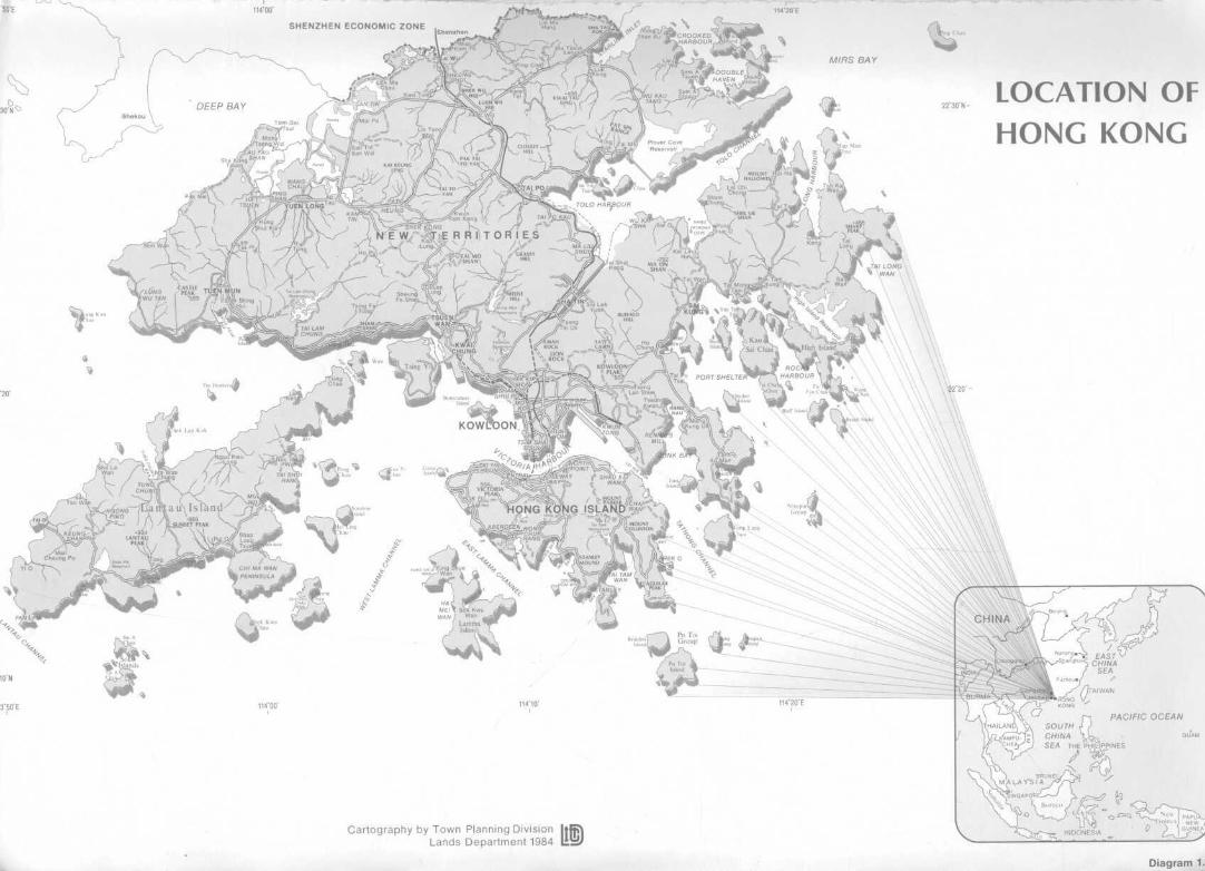
LOCATION OFHONG KONG
Cartography by Town Planning DivisionLands Department 1984
Diagram 1-'

SHENZHEN ECONOMIC ZONE
MIPS BAY
,,,, -f3l^
Cartography by Town Planning Division ILands Department 1984 I
LOCATION OF NEW TOWN &RELIEF OF HONG KONG
Diagram 1.2

TSUEN WAN
N O T A T I O N
RECLAMATION UP TO 1887
RECLAMATION BETWEEN 1887 & 19CU
RECLAMATION BETWEEN 1904 & 1924
RECLAMATION BETWEEN 1924 & 1945
RECLAMATION BETWEEN 1945 & 1967
RECLAMATION BETWEEN 1967 & 1976
RECLAMATION BETWEEN 1976 & 1982
N O T E : P O S I T I O N AS AT JULY 1982
SOURCE : PORT WORKS DIVISION
HONG KONG HARBOUR - STAGES OF RECLAMATION

ti&Mt n
*.%•,
$•••HISQUATTER AREAS OFF SHAU KEI WAN ROAD
jm ?j)>f5« i' I

SHENZHEN ECONOMIC ZONE
CROOKED CrookedHARBOUR Island
Shekou
DEEP BAY
DOUBLEHAVEN ?c?lb>'
X
MIRS BAY
MOUNT Hoi Ha <tHALLOWES If ^i
Sharp Kau ^^=: =lsland Sai Chau H'gh Island =
ROCKY
PORT SHELTER HARBOUR
Chau Fan"chaauU
NinepinGroup
LEGEND
Main Road
Mass Transit Railway
Kowloon-Canton Railway
Proposed Light Rail Transit
Proposed N.T. Circular Road
(Sections)
Beaufort rfr(X°' Sung WaglanIsland Kong Island
SokoIslands
10 12 14 kmCartography by Town Planning Division
Lands Department 1984
TRANSPORTATION SYSTEMIN HONG KONG
Diagram 1.5

H.E. THE GOVERNOR
EXECUTIVE/LEGISLATIVE COUNCIL
CHIEF SECRETARY I
SPECIALCOMMITTEE ONLAND SUPPLY
LANDS AND WORKS BRANCH
LandsDivision -c Lands Policy
Unit
StrategicPlanningUnit
Urban Arear— Development
... . OrganizationWorksDivision I _
I ProgrammeL- Co-ordina-
tion Unit
AdministrationDivision
Housing Department
Administration andPlanning Branch
Estate ManagementBranch
Operations Branch
Construction Branch
Building DevelopmentDepartment
Architectural Office
Buildings OrdinanceOffice
Engineering DevelopmentDepartment
Civil Engineering Office
Highways Office
Geotechnical Control Office
Mass Transit Office
Railway Development Office
TRABRA
Lands Department
Town Planning Division
Lands Division
Survey Division
New Territories DevelopmentDepartment
Sha Tin New Town Develop-ment Office
Tsuen Wan New Town Develop-ment Office
Tuen Mun New Town Develop-ment Office
Tai Po & Fanling DevelopmentOffice
Junk Bay Development Office
N.T. Development Branch
Transpor
Administ
PlanningBranch
Hong KOIOffice
Kowloon
NT. Reg
ORGANIZATION STRUCTURE OF THE HONG KONG GOVERNDIRECTLY INVOLVED IN LAND USE PLANNING

H.E. THE GOVERNOR
EXECUTIVE/LEGISLATIVE COUNCIL
I
LAND DEVELOP-MENT POLICYCOMMITTEE
CHIEF SECRETARY IENVIRONMENTALPROTECTIONADVISORY COMMITTEE
LANDS AND WORKS BRANCH
LandsDivision
WorksDivision
-[-T
Lands PolicyUnit
StrategicPlanningUnit
Urban AreaDevelopmentOrganization
I ProgrammeCo-ordina-tion Unit
AdministrationDivision
Lands Department
Town Planning Divisio
Lands Division
Survey Division
New Territories DevelopmentDepartment
Sha Tin New Town Develop-ment Office
Tsuen Wan New Town Develop-ment Office
Tuen Mun New Town Develop-ment Office
Tai Po & Fanling DevelopmentOffice
Junk Bay Development Office
N.T. Development Branch
HEALTH & WELFAREBRANCH
Transport Department
Administration andLicensing Branch
Planning and ResearchBranch
Hong Kong RegionalOffice
Kowloon Regional Office
N.T. Regional Office
EnvironmentalProtection Agency
• Air Quality &Hazard AssessmentGroup
• Noise and VibrationGroup
• Water Quality Group
• Waste ManagementPlanning Group
Urban Services Department
City Services
PlanningandDevelop-mentDivision
CulturalServices
AntiquitiesandMonumentsOffice
N.T.Services
PlanningSection
3ANIZATION STRUCTURE OF THE HONG KONG GOVERNMENTDIRECTLY INVOLVED IN LAND USE PLANNING
Diagram 3.1

Principal Government Town Planner
r
Government Town Planner/Conceptual
I 1Planning Staff i
| Seconded to I, UADO, NTDD and II SPU j
I 1
Structure PlanningSection
Planning Standardsand Studies Section
Statutory PlanningSection
Central Informationand Technical Admin-istration Unit/Design and LayoutUnit
TOWN PLANNING DIVISION
ORGANIZATION CHART
Diagram 3,2

Director of New Territories Development
Deputy Director of New Territories Development
Headquarters DevelopmentOffices
Technical AdministrativeSupport ServicesServices:
Engineering
Planning
Landscaping
AccountingServices
Sha TinNew TownDevelopmentOffice
Tai Po &FanlingDevelopmentOffice
Junk BayDevelopmentOffice
Tsuen WanNew TownDevelopmentOffice
Tuen MunNew TownDevelopmentOffice
NT DevelopmentBranch
NEW TERRITORIES DEVELOPMENT DEPARTMENT
ORGANIZATION CHART
Diagram 3.3

Urban Area Development Advisor
Development Manager/Kowloon
NE Kowloon(includesWong Tai SinandKwun Tong)
KowloonCity
ShamShuiPo
YauMaTei
MongKok
Eastern Southern
Government TownPlanner/Urban
Urban Area DistrictPlanning Division
WanChai
Central&
Western
Headquarters HKSection
KowloonSection
URBAN AREA DEVELOPMENT ORGANIZATIONORGANIZATION CHART
Diagram 3.4
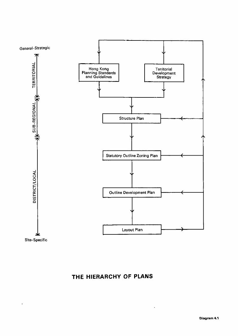
General-Strategic
ccO
EDCLU
ZO
QQD
OO
Site-Specific
Hong KongPlanning Standards
and Guidelines
TerritorialDevelopment
Strategy
Structure Plan
Statutory Outline Zoning Plan
Outline Development Plan
Layout Plan
THE HIERARCHY OF PLANS
Diagram 4,1

(1) (2)Possible preliminary ExComemo; when policyformulation, extension orclarification necessary
Depts/Branches submit requests for review ofstandards/policies to PSSC, or PSSC initiates,through Secretary for Lands and Works (SLW) asand when required. PSSC proposes interdepartmentalWorking Group(s) for substantial reviews
(3) N/
SLW, in association with Branches/Depts. directlyconcerned, circulates proposed terms of reference toWorking Group.
(5) (4)Draft report vetted byDepartments/Branchesconcerned; reference toany relevant specialistcommittees
\
Working Groups convene and produce draft report;policy status and outline financial implications ofall proposals to be included where practical &appropriate.
(6)Working Groups submit draft report with summaryof interdepartmental comments to PSSC.PSSC considers general policy implications andany outstanding points-of-issue.
(7)Final report submitted to LDPC for endorsement,with recommendation on need for ExCo submission.
(8)ExCo memo on proposed major revisions.
(9)Revised/new standards initially circulated toBranches/Departments by SLW. PGTP circulates anyadditional copies requested, and supplies workingcopies to all professional planning officers.
PLANNING STANDARDS SUB-COMMITTEE (PSSC):OUTLINE OF PROCEDURES
Diaaram 4.2

STRUCTURE PLAN FORNORTH EASTERN NEW TERRITORIES
SHENZHEN SPECIAL ECONOMIC ZONE
m mT A I PANG WAN
( M I R S BAY)
€jo YUENLONG
JO-YUEN/ LONG
AREA EXCLUDED FROM MOCK-UP
NENT STRUCTURE PLAN DUE TO
EXPEDIENCE AND TIME CONSTRAINT
KEY DIAGRAM
NOTATION
Ijjj GENERAL AREA FOR URBAN USES WITHIN THEI NEW TOWNS
I INDUSTRIAL
I POTENTIAL DEVELOPMENT AREA
INFORMAL DEVELOPMENT AREA
AGRICULTURE PRIORITY AREA
EXPANSION OF SETTLEMENT
RURAL CENTRE
LIVESTOCK UPGRADING SITE
MARICULTURE SITE
COUNTRY PARK
URBAN FRINGE PARK
RURAL PARK
RECREATION PRIORITY AREA
LOW INTENSITY RECREATION USE AREA
LOW INTENSITY RECREATION USE AREA INCOUNTRY PARK
SPECIAL AREA
SITE OF SPECIAL SCIENTIFIC INTEREST
IN-SHORE WATER BASED RECREATION AREA
MARINA
CONTROLLED TIP SITE WITH RECREATIONAFTER-USE
MAJOR ROADS (DUAL 2/3 LANE CARRIAGEWAY)
MINOR ROADS (SINGLE CARRIAGEWAY)
SHA TAU KOK BY-PASS
—(§>— RAILWAY/K.C.RSTATION (TRANSPORT INTERCHANGE)
ACTION AREAMILITARY AREALililllLI
CEMETERY
GOLF COURSE
ST | SEWAGE TREATMENT WORKS
HOSPITAL
BOUNDARY OF NEW TOWN (AREA ALSO COVEREDBY NEW TOWN 0. D. P.)
mi • FRONTIER/CLOSED AREA'BOUNDARY
BOUNDARY OF AREA COVERED BY NENT' STRUCTURE PLAN
TOWN PLANNING DIVISION
LANDS DEPARTMENT
PLAN REF. No. SRNE-ST83/2
FILE REF. No.
DATE Sept., 1983
FIG. No.

SHENZHEN ECONOMIC ZONE
NORTH EASTERN TERRITORIES
NORTH WESTERN NEW TERRTORIES
EASTERN NEW TERRITORIESBAYV
NEW TOWNfc
SOUTH WESTERN CNEW TERRITORIES
SCALE
k m O 1 2 3 4 5 6 7 8 9 1 0 k mhull I I I I I I I I I
NOTATION
BOUNDARY OF
SUB-REGIONAL DIVISION
NEW TOWN
NEW TOWN EXTENSION
SOURCES
BOUNDARIES OF SUB-REGIONAL DIVISIONSTOWN PLANNING DIVISION
LANDS DEPARTMENT
PLAN REF. No. SRHK- OT 82 /305
FILE REF. No.
DATE
Dec.,82
FIG. No.
Diagram 4.4

VICTORIA HARBOUR
S * # $
kft PARKS / SHOPS / SUPERMARKETSHOWROOMS OFFICES BUT EXCLUDIN
AL ACCOMMODATION INCLUDIN
AMENDMENT TO DRAFT PLAN NO. L H 5 / 3 5 C
EXHIBITED UNDER SECTION 7 OF THE TOWN
PLANNING ORDINANCE ON THE 2 nd DAY OF
JANUARY, 1 9 8 1 .
SECRETARYTOWN PLANNING BOARD.
TOWN PLANNING ORDINANCE, HONG KONG TOWN PLANNHONG KONG PLANNING AREA No. 5 WAN CHAI • OUTLINE Z<
* METRES 100 tOO MITRES *
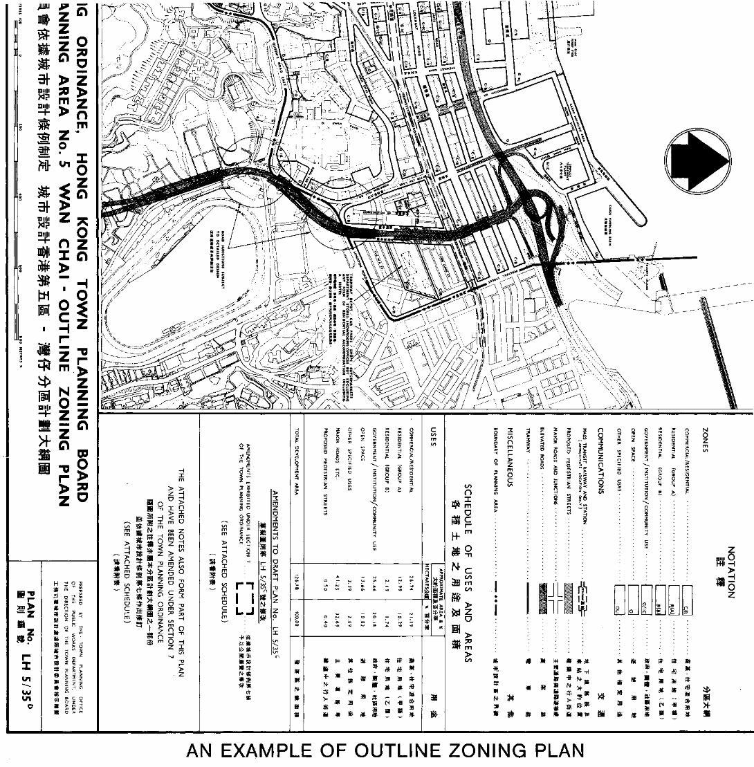
/U1IU
LI
a S>
D
Z
*Dim
I"
zm
vn
H$.3
> >
«!1> 31
> 5H 3f
- ^ *IS n =P
H <
O
Z >^. >
- O
1 $ > 6 o
5 S l s s5»
Sfc ™ ^WT *L -,
m •>^ ?o
I z O O^ n =! •"* m O Hz x
Z ro
Z H
2 2Z ^
nI I I
L J
O
-O 3 O O O 73 7>2? > H -a o m m
O ^ I m < ^ ^
b TI$ n
5° 3" =
03 > >
0 0 —
W
« rS B91
ft - -IS51 CN -ffl
I ; ;
cttWJD>
P 2
GO
O
n
I °? 00
CGO
SBW
si
no2
Zn
< _ ^NOz
z o Hv\ 7> 7>iJ o oH C CC -o -o
6 2 >
JLir *
ah*
* * * w > f -! :
mm&
*D>
^«
x-
AN EXAMPLE OF OUTLINE ZONING PLAN

Instruction to prepare a statutory plan,or to revoke, amend or replace anexisting statutory p!an by a new one
_._. . r _T . . . _ . , N Drawing up of plan
r _^rirr >|
~i
Plan circulated to relevant governmentdepartments for comments/information
Comments received
Appropriate amendmentsincorporated in the plan
Presentation to District ManagementCommittee/District Boardif considered appropriate
Submission to LDPCfor financial implications
Furtheramendmentsmade by theTPB to a"draft plan"under Section(6) or (7), ifnecessary
Plan submitted to theTPB for consideration
L . . .__ V
J_Refer to TPBfor furtherconsiderationand amendment
Plan gazetted and exhibitedfor public inspection
Preliminary consideration of objectionsby the Town Planning Board
Hearing of objections by theTPB and incorporating amendmentin the plan, if necessaryi • i
Plan submitted to Governorin Council for approval
Approved plan published
Note: Procedure may be repeatedas indicated by dotted line
TPB —Town Planning Board
MAJOR STEPS IN THE PREPARATIONOF STATUTORY PLANS
Diagram 4.6
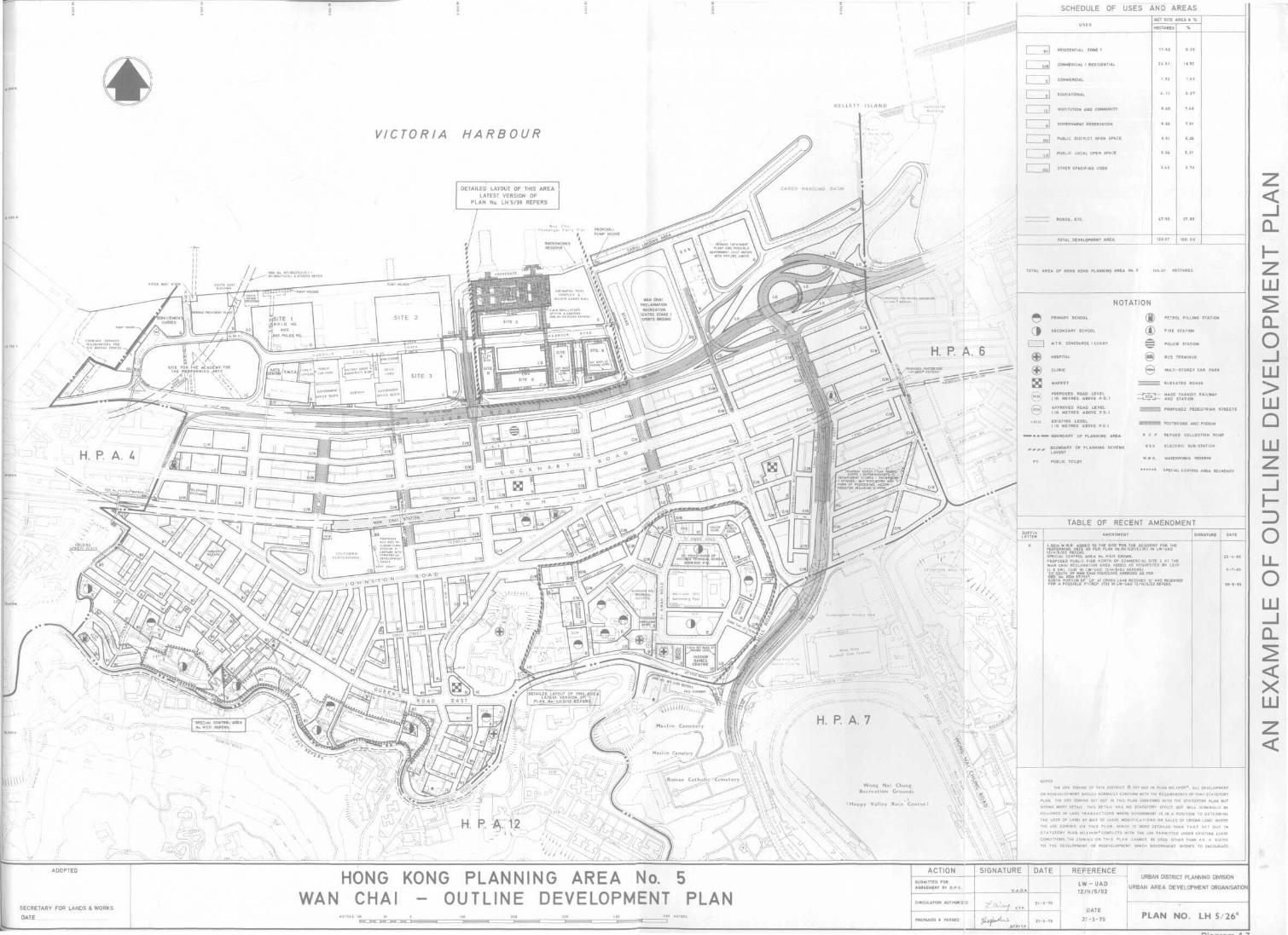
SCHEDULE OF USES AND AREAS
INSTITUTION AND COMMUNITY
GOVERNMENT RESERVATION
PUBLIC DISTRICT OPEN SPACE
^H PUBLIC LOCAL OPEN SPACE
OTHER SPECIFIED USES
VICTORIA HARBOUR
DETAILED LAYOUT OF THIS AREA !LATEST VERSION OF
PLAN No. LH 5/38 REFERS
TABLE OF RECENT AMENDMENT
D TO THE SITE FOR THE ACADEMY FOR 1
12/H/5/02 REFERSSPECIAL CONTROL AREA No. H5 /1 SHOWN.
UBLIC PIER NORTH OF COMMERCIAL SITE 2 AT
ECLAMATION AREA ADDED AS REQUESTED BY L
LO SOU1H OF WAN CHAI POLYCLINIC AMENDED AS PER
. No. RDH 67/113*.TH PORTION OF 'LO' AT CROSS LANE REZONED 'G' AND RESERVE
•D I2 /H /5 /02 REFERS.
' Happy Val ley Race Course)
SECRETARY FOR LANDS & WORKS
DATE
HONG KONG PLANNING AREA No. 5WAN CHAI - OUTLINE DEVELOPMENT PLAN
ACTION
CIRCULATION AUTHORIZED
PREPARED * PASSED
SIGNATURE DATE I REFERENCEURBAN DISTRICT PLANNING DIVISION
LW - UAD | URBAN AREA DEVELOPMENT ORGANISATION
DATE
21-3-79 21-3-79 PLAN NO. LH 5/26K

SCHEDULE OF USES AND ,
m pi
iOAD JUNCTION SUBJECTfO DETAILED DESIGN
THE USE ZONING OF THIS DISTRICT IS SET OUT IN PLAN No. LH 5/35° ALL DEVELOPMENT
OR REDEVELOPMENT SHOULD NORMALLY CONFORM WITH THE REQUIREMENTS OF THAT
PLAN. THE USE ZONING SET OUT IN THIS PLAN CONFORMS WITH THE STATUTORY PLAN BUT
SHOWS MORE DETAIL. THIS DETAIL HAS NO STATUTORY EFFECT BUT WILL GENERALLY BE
FOLLOWED IN LAND TRANSACTIONS WHERE GOVERNMENT IS IN A POSITION TO DETERMINE
.AND BY WAY OF LEASE MODIFICATIONS OR SALES OF CROWN LAND.
THE USE ZONING ON THIS PLAN, WHICH IS MORE DETAILED THAN T H A T SET OUT IN
S T A T U T O R Y PLAN No.LH5/35° CONFLICTS WITH THE USE PERMITTED UNDER EXISTING LEASE
CONDITIONS, THE ZONING ON THIS PLAN CANNOT BE USED OTHER THAN AS A GUIDE
TO THE DEVELOPMENT OR REDEVELOPMENT WHICH GOVERNMENT WISHES TO ENCOURAGE.
HONG KONG PLANNING AREA No. 5WAN CHAI RECLAMATION - . A Y O U T PLAN
URBAN DISTRICT PLANNING TEAM
URBAN AREA DEVELOPMENT ORGANISATION

M/flS 8,4 Y
8 10 12 14 kit Cartography by Town Planning DivisionLands Department 1984
RESERVOIRS ANDGATHERING GROUNDS
Diaaram 5.1

JHong KcW Country Parks
itry Parks
Special A
lib Bf ¥ M ffi Iiv It tf 13 — A A EB £.Cartoaranhv hv Town Plannina Division. Lands Deoartment 1984

SHEK TONG TSUI
10/
KENNEDY TOWN
ZONING - HONG KONG ISLAND
DENSITY ZONING BOUNDARY
DENSITY ZONING - ZONE 1
- ZONE 2
-ZONE 3

KOWiOJN/x•^-••"-"txr"""
DENSITY ZONING BOUNDARY
DENSITY ZONING - ZONE 1
-ZONE 2
- ZONE 3
Diagram 5-3b
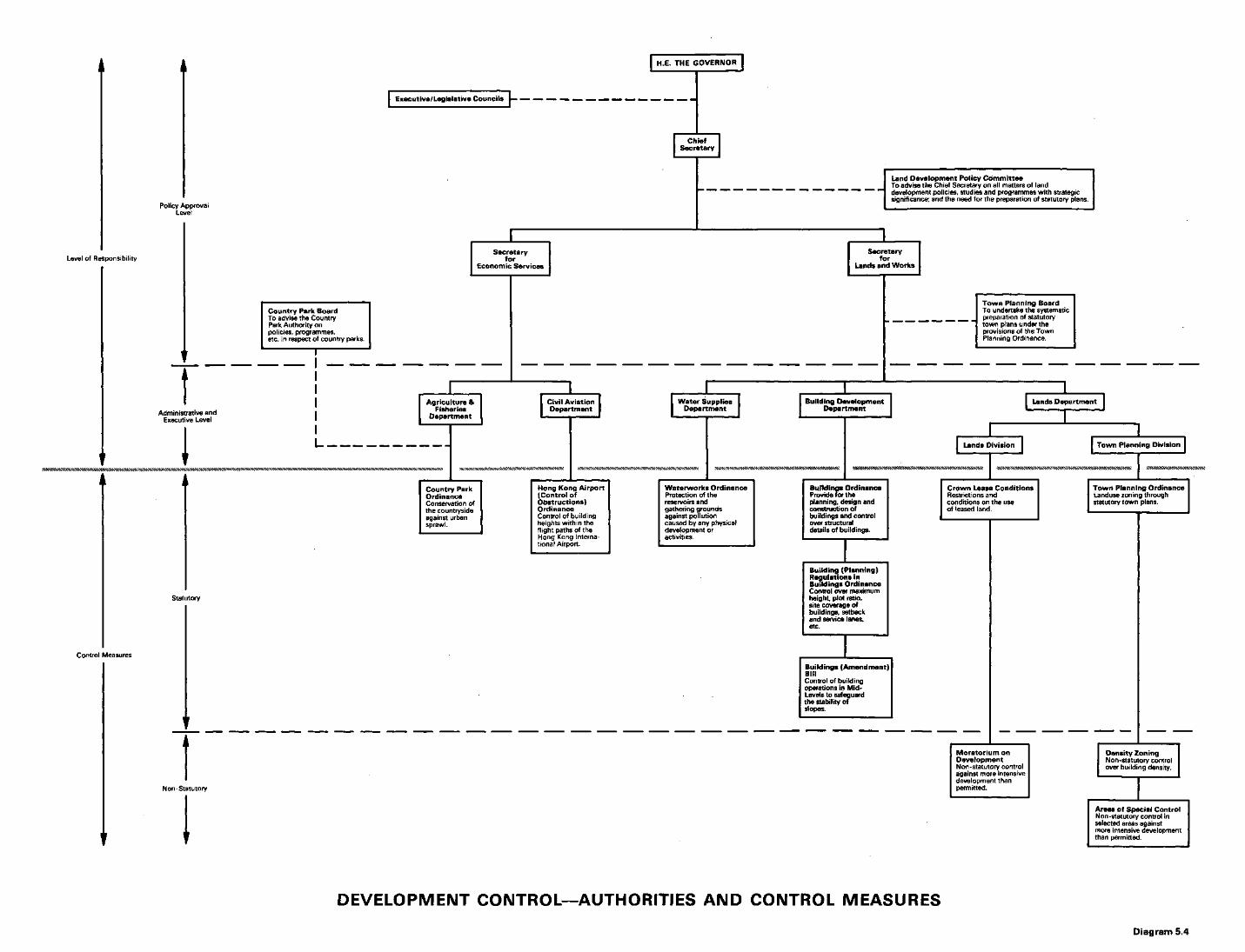
H.E. THE GOVERNOR
Executive/Legislative Councils
ChiefSecretary
Policy ApprovalLevel
Level of Responsibility
Land Development Policy CommitteeTo advise the Chief Secretary on all matters of landdevelopment policies, studies and programmes with strategicsignificance; and the need for the preparation of statutory plans.
Country Park BoardTo advise the CountryPark Authority onpolicies, programmes,etc. in respect of country parks.
Town Planning BoardTo undertake the systematicpreparation of statutorytown plans under theprovisions of the TownPlanning Ordinance.
Water SuppliesDepartment
Building DevelopmentDepartment
Waterworks OrdinanceProtection of thereservoirs andgathering groundsagainst pollutioncaused by any physicaldevelopment oractivities.
Lands Department
[ Lan.ids Division Town Planning Division
Buildings OrdinanceProvide for theplanning, design andconstruction ofbuildings and controlover structuraldetails of buildings.
Crown Lease ConditionsRestrictions andconditions on the useof leased land.
Statutory
Control Measures
Building (Planning)Regulations inBuildings OrdinanceControl over maximumheight, plot ratio,site coverage ofbuildings, setbackand service lanes,etc.
Buildings (Amendment)BillControl of buildingoperations in Mid-Levels to safeguardthe stability ofslopes.
N on-Statutory
*SS«**«SN*««W*S SJW^^SW^K***
Town Planning OrdinanceLanduse zoning throughstatutory town plans.
Density ZoningNon -statutory controlover building density.
Areas of Special ControlNon-statutory control inselected areas againstmore intensive developmentthan permitted.
DEVELOPMENT CONTROL—AUTHORITIES AND CONTROL MEASURES
Diagram BA

POPULATIOISNDISTRIBUTION &HOUSING MIX OF NE\/V^T0 TAI PANG WAN
(MIRS BAY)
NEW TERRITORIESj
LEGEND
ULTIMATE POPULATION
Cartography by Town Planning Division ILands Department 1984

LUBJDBJQ
g69/±S1 -ON Nvid
dWOS ONINNVId NMO1 3H1 dO
NOI1D3MIO 3H1 M3aNfl iN3WJ.WVd3Q SQNVT dO
NOISIAIQ ONINNVnd NMOi 3H1 A3 (D3MVd3yd
Hi«¥il4IB# - H 4 ? ii|i»NVTd DNINOZ 3NI1J.no Nl± VMS
OHV09 DNINNVld NMO1 ONO>I ONOH '3DNVNIC1UO DNINNVTd NMOJ.
(3ina3HDS Q3HDV11V 33S)
a 6 9 / 1 S T 'ON NVld UVya 01 S1N3WQN3WV
( ttttiftil )
(3ina3HDS Q3HDV11V 33S)
SDNVNiaVIO DNINNVld NMOI 3H1 dO
L NOUD3S yaaNn asaNSwv N33a SAVH QNVNVld SIH1 dO lyVd WyOd OSIV S31ON 03HDV11V 3H1
» • « 7 • • •
V3W 3W3HDS DNINNVId 1V1O1
±139 N33«9
savoa dorvw
H3NNVHO M3AIM
S3Sn Q3ld03dS «3H10
30VdS N3dO
NOIiniliSNI /1N3WNU3AOD
3 »IN 3D NMOi
xo) -iviiN3ais3*i
SV3W QNV dO
4S ? ffl 41 S — - — - -- 3W3HDS DNINNVld JO
SnO3NV113DSIW-F* I -
iviaisnaNi
33VdS N3dO
* » » » • » • • « ( « — -
* W S » W » - - --
--- AllNOWWOD / NOIiniliSNI 7iN3WN>i3AOO
3Wd013A3Q 3dAl 30V11IA
; avoa
£ avoy
avo» XNOMI
SNOIIVDINHNWOD
NOIIVION
m^Wm '<!:.im K^mls- Km<, \^~^^ - ^_
1 ' "Tcr\,Vi , Y -'' :
:-?V\
(591
©©
,M
*®
'0,*0> ^
. ,I* / T3NNH1 Tll« NODV38
-ONOD3S Q3SOdO»dr JO 3NH 3»iN3D
E£
-®(67)
J
\-»*>,>-s\wvc^^vvS'i?r / V '; v' f { / \
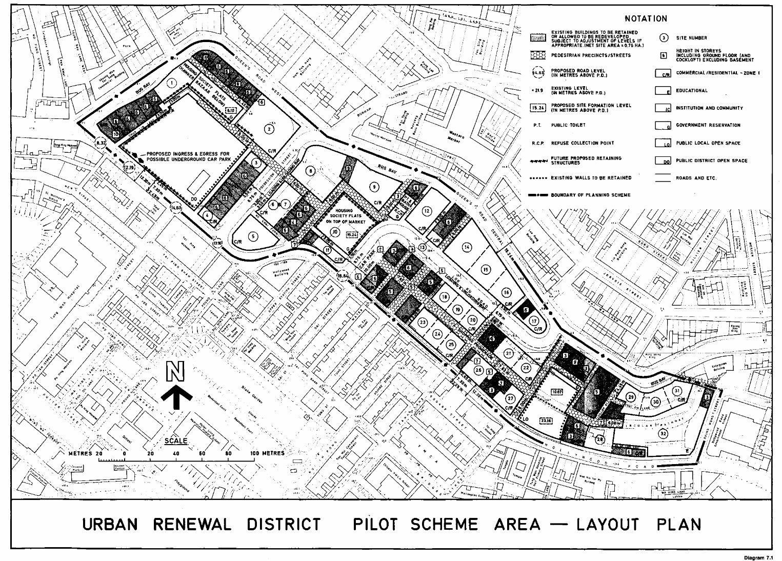
NOTATION
3 j SITE NUMBER
HEIGHT IN STOREYS6 | INCLUDING GROUND FLOOR (AND
COCKLOFT) EXCLUDING BASEMENT
COMMERCIAL /RESIDENTIAL -ZONE 1
INSTITUTION AND COMMUNITY
-^ /
EXISTING BUILDINGS TO BE RETAINED[""""] OR ALLOWED TO BE REDEVELOPED
SUBJECT TO ADJUSTMENT OF LEVELS IFAPPROPRIATE.(NET SITE AREA = 0.76 HA.)
PEDESTRIAN PRECINCTS/STREETS
PROPOSED ROAD LEVEL(IN METRES ABOVE P.D.)
EXISTING LEVEL(IN METRES ABOVE P.D.i
PROPOSED SITE FORMATION LEVEL_ (IN METRES ABOVE P.O.)
P.T. PUBLIC TOILET GOVERNMENT RESERVATION
R.C.P. REFUSE COLLECTION POINT PUBLIC LOCAL OPEN SPACE
PROPOSED INGRESS & EGRESS FPOSSIBLE UNDERGROUND CAR PARK FUTURE PROPOSED RETAINING
STRUCTURES PUBLIC DISTRICT OPEN SPACE
ROADS AND ETC.EXISTING WALLS TO BE RETAINED
BOUNDARY OF PLANNING SCHEME
HOUSINGSOCIETY FLATS
URBAN RENEWAL DISTRICT PILOT SCHEME AREA LAYOUT PLAN
Diagram 7.1
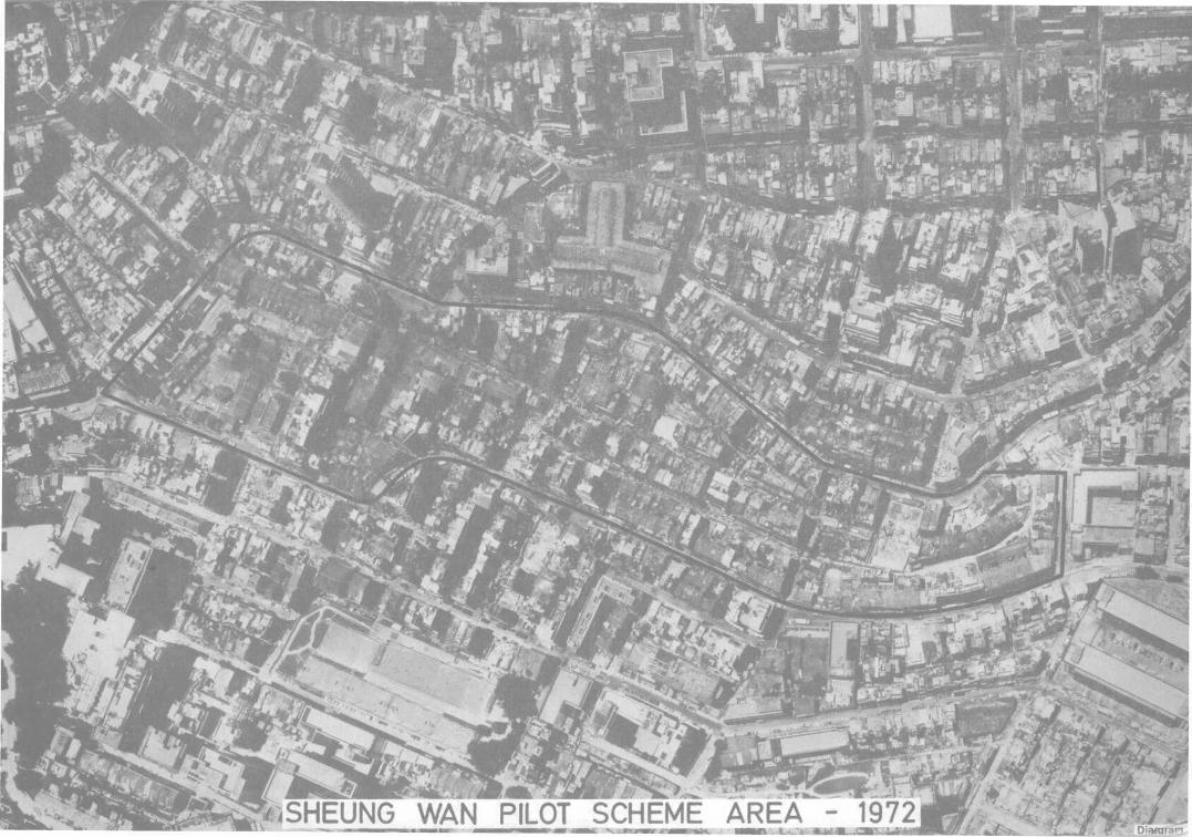
%T,jS£j8Oi».;
f
•pi
•SHEUNG WAN PILOT SCHEME AREA -

ISHEUNG WAN PILOT SCHEME AREA

Formerly the " Urban Renewal DistrictTS
SHEK TONG TUR
CHUNG WAN(CENTRAL DISTRICT)
SOURCES
URBAN RENEWAL IN THE

PAK KOK(NORTH POINT
mmmtUNG LO WAN
(CAUSEWAY BAY)
/ »ff
WAN CHAI »«?"«*
HAPPYVALLE
;LOOKQUT
\\ *»**11 '" ™"7 \ RESERVOIR
«
NOTATION
PILOT SCHEME AREA
ENVIRONMENTAL IMPROVEMENTAREA
COMPREHENSIVE DEVELOPMENTAREA
URBAN IMPROVEMENT SCHEME( HOUSING SOCIETY )
—,«,—. PLANNING AREA BOUNDARY
THE MAIN URBAN AREAS - HONG KONG ISLANDTOWN PLANNING DIVISION
LANDS DEPARTMENT
PLAN REF. No. SRMU-OT82/6
FILE REF. No.
DATE
Nov., 82
FIG. No.
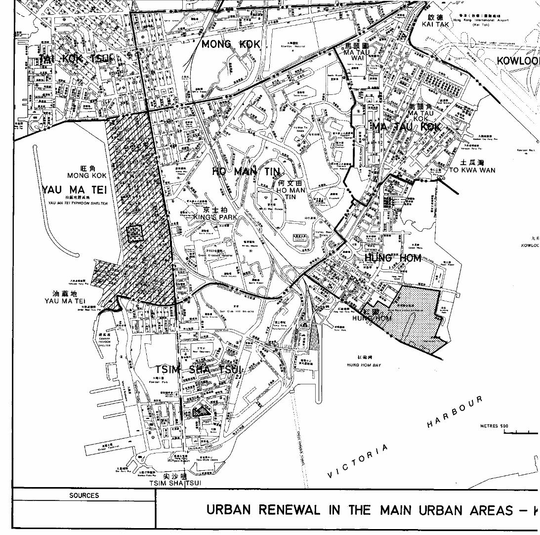
URBAN RENEWAL IN THE MAIN URBAN AREAS - (•

HU
earnG HOM
SCALE
METRES 500 500 1 000 METRESI
0
NOTATION
ENVIRONMENTAL IMPROVEMENT AREA
•<#*&': COMPREHENSIVE DEVELOPMENT AREA
;>;•;.*; SIX STREETS REDEVELOPMENT
PLANNING AREA BOUNDARY
THE MAIN URBAN AREAS - KOWLOON & NEW KOWLOONTOWN PLANNING DIVISION
LANDS DEPARTMENT
PLAN REF.No. SRMU-OT82/7
FILE REF.No.
DATE
Nov.,82
FIG.No.
Diagram 7-3b

o

XU1?2Q43«4
* X O 1 7 2 0 4 3 4 *
HK711.095125
Hong Kong. Lands DeptPanning Division
\>\>,,.Date Due l33979i-0/
3?;:,' -. ,
*tit(f f /lifeI 1 I ^
M
-8 CCT 1!
3T FOI LC
11
AN^
t*