Embed Size (px)
Citation preview
Federal Insurance and Mitigation Administration
Homeowner's Guide to Elevation Certificates An Elevation Certificate is an important tool that documents your building's elevation. If you live in a high-risk flood zone, you should provide an Elevation Certificate to your insurance agent to obtain flood insurance and ensure that your premium accurately reflects your risk. Obtaining an Elevation Certificate also can help you make decisions about rebuilding and mitigation after a disaster.
Comparing Your Building's Elevation to a Potential Flood Level
• Your insurance agent will use the Elevation Certificate to compare your building's elevation to the Base Flood Elevation (BFE).
• The base flood is a flood with a 1 percent chance of occurring in any given year. The BFE identifies how high the water is likely to rise (also called water surface elevation) in a base flood. The land area of the base flood is called the Special Flood Hazard Area, floodplain, or high-risk zone.
• Flood insurance rates in a high-risk zone (a zone beginning with the letter A or V) are based on a building's elevation above, at, or below the BFE.
Elevation and Flood Insurance Rates
• Generally, in high-risk zones, the higher above the BFE a building is located, the lower the insurance premium will be for that property. The Elevation Certificate provides the documentation necessary to make that determination.
• In moderate- to low-risk zones (zones beginning with letters B, C, or X), rates are not based on elevation, so an Elevation Certificate may not be necessary to determine the premium.
Finding Your Building's Elevation
• Many municipal governments keep elevation information on file. Talk to community officials about the information they might have for your building.
• If no elevation information is available, you might need to hire a State-licensed surveyor, architect, or engineer to complete an Elevation Certificate. Depending on your location and the complexity of the job, the cost of a surveyor can vary from $500 to $2,000 or more. You may want to contact several local surveyors to find out what they offer.
HOW TO GET AN ELEVATION CERTIFICATE FOR YOUR HOME
1. Ask your local floodplain manager if your property's elevation information is on file. If so, the community floodplain manager is authorized to complete the Elevation Certificate for you.
2. If your information is not on file, you might need to hire a State-licensed surveyor to obtain an Elevation Certificate.
3. When you receive your Elevation Certificate:
Provide one copy to your insurance agent. • Keep a copy for your records.
WHAT DISASTER SURVIVORS NEED TO KNOW
An Elevation Certificate will help your agent rate your policy properly.
Your insurance premium will change based on your elevation. In general, the higher above the BFE you build, the lower your premium.
Your home might be above the BFE, so you might already be eligible for lower premiums.
An Elevation Certification can help you make decisions about the return on investment of mitigation efforts as your rebuild.
"FEMA's mission is to support our citizens and first responders to ensure that as a nation we work together to build, sustain, and improve our capability for, protect against, respond to, recover from, and mitigate all hazards."
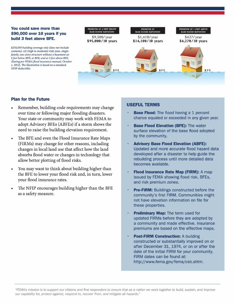
You could save more than $90,000 over 10 years if you build 3 feet above BFE.
$250,000 building coverage only (does not include contents), AE (high to moderate risk) zone, singlefamily, one-story structure without a basement at: 4 feet below BFE; at BFE; and at 3 feet above BFE. (Rating per FEMA flood insurance manual, October 1, 2012). The illustration is based on a standard NFIP deductible.
Plan for the Future
PREM] UM AT 4 FEET BELOW
BASE FLOOD ELEVATION
$9,500/ year $95,000/10 years
• Remember, building code requirements may change over time or following major flooding disasters. Your state or community may work with FEMA to adopt Advisory BFEs (ABFEs) if a storm shows the need to raise the building elevation requirement.
• The BFE and even the Flood Insurance Rate Maps (FIRMs) may change for other reasons, including changes in local land use that affect how the land absorbs flood water or changes in technology that allow better plotting of flood risks.
• You may want to think about building higher than the BFE to lower your flood risk and, in turn, lower your flood insurance rates.
• The NFIP encourages building higher than the BFE as a safety measure.
PREMIUM AT RASE FLOOD ELEVATION
$ 1,41 0/year $14,100/10 years
USEFUL TERMS
PREMIUM AT I FEET ABOVE
BASE FLOOD ELEVATION
$427/ year $4,270 / 10 years
BFE
Base Flood: The flood having a 1 percent chance equaled or exceeded in any given year.
Base Flood Elevation (BFE): The water surface elevation of the base flood adopted by the community.
Advisory Base Flood Elevation (ABFE): Updated and more accurate flood hazard data developed after a disaster to help guide the rebuilding process until more detailed data becomes available.
Flood Insurance Rate Map (FIRM): A map issued by FEMA showing flood risk, BFEs, and risk premium zones.
Pre-FIRM: Buildings constructed before the community's first FIRM. Communities might not have elevation information on file for these properties.
Preliminary Map: The term used for updated FIRMs before they are adopted by a community and made effective. Insurance premiums are based on the effective maps.
Post-FIRM Construction: A building constructed or substantially improved on or after December 31, 1974, or on or after the date of the initial FIRM for your community. FIRM dates can be found at: http://www.fema.gov/fema/csb.shtm.
"FEMA's mission is to support our citizens and first responders to ensure that as a nation we work together to build, sustain, and improve our capability for, protect against, respond to, recover from, and mitigate all hazards."