Embed Size (px)
Citation preview
4/30/08 12:19 PMWomen Exploring the Oceans
Page 1 of 5http://www.womenoceanographers.org/Default.aspx?pid=E1E3254E-1C80-4e6d-ABBF-1EC5F5436C3E&id=DawnWright
Home About Us Site Map XML/RSS
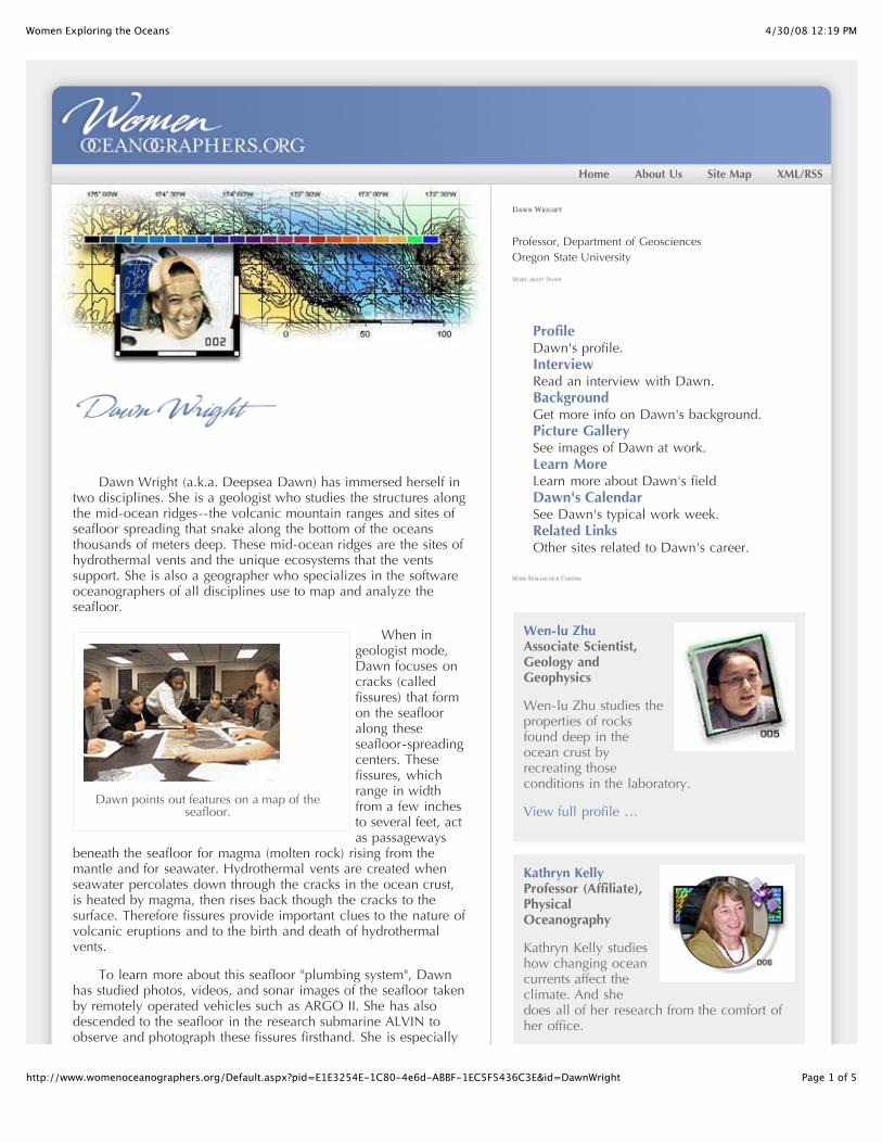
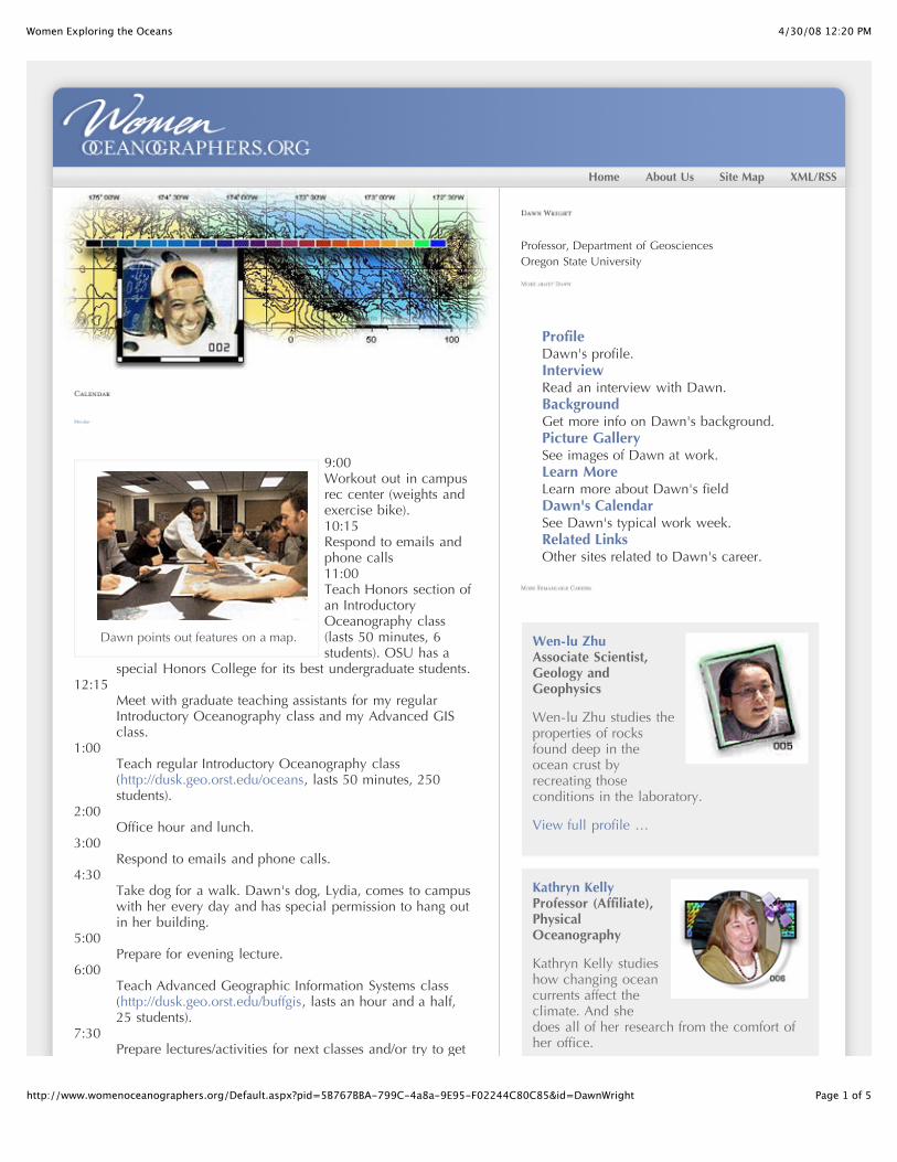
Dawn points out features on a map of theseafloor.
Dawn Wright (a.k.a. Deepsea Dawn) has immersed herself intwo disciplines. She is a geologist who studies the structures alongthe mid-ocean ridges--the volcanic mountain ranges and sites ofseafloor spreading that snake along the bottom of the oceansthousands of meters deep. These mid-ocean ridges are the sites ofhydrothermal vents and the unique ecosystems that the ventssupport. She is also a geographer who specializes in the softwareoceanographers of all disciplines use to map and analyze theseafloor.
When ingeologist mode,Dawn focuses oncracks (calledfissures) that formon the seaflooralong theseseafloor-spreadingcenters. Thesefissures, whichrange in widthfrom a few inchesto several feet, actas passageways
beneath the seafloor for magma (molten rock) rising from themantle and for seawater. Hydrothermal vents are created whenseawater percolates down through the cracks in the ocean crust,is heated by magma, then rises back though the cracks to thesurface. Therefore fissures provide important clues to the nature ofvolcanic eruptions and to the birth and death of hydrothermalvents.
To learn more about this seafloor "plumbing system", Dawnhas studied photos, videos, and sonar images of the seafloor takenby remotely operated vehicles such as ARGO II. She has alsodescended to the seafloor in the research submarine ALVIN toobserve and photograph these fissures firsthand. She is especially
Professor, Department of GeosciencesOregon State University
ProfileDawn's profile.InterviewRead an interview with Dawn.BackgroundGet more info on Dawn's background.Picture GallerySee images of Dawn at work.Learn MoreLearn more about Dawn's fieldDawn's CalendarSee Dawn's typical work week.Related LinksOther sites related to Dawn's career.
Wen-lu ZhuAssociate Scientist,Geology andGeophysics
Wen-lu Zhu studies theproperties of rocksfound deep in theocean crust byrecreating thoseconditions in the laboratory.
View full profile …
Kathryn KellyProfessor (Affiliate),PhysicalOceanography
Kathryn Kelly studieshow changing oceancurrents affect theclimate. And shedoes all of her research from the comfort ofher office.

4/30/08 12:19 PMWomen Exploring the Oceans
Page 2 of 5http://www.womenoceanographers.org/Default.aspx?pid=E1E3254E-1C80-4e6d-ABBF-1EC5F5436C3E&id=DawnWright
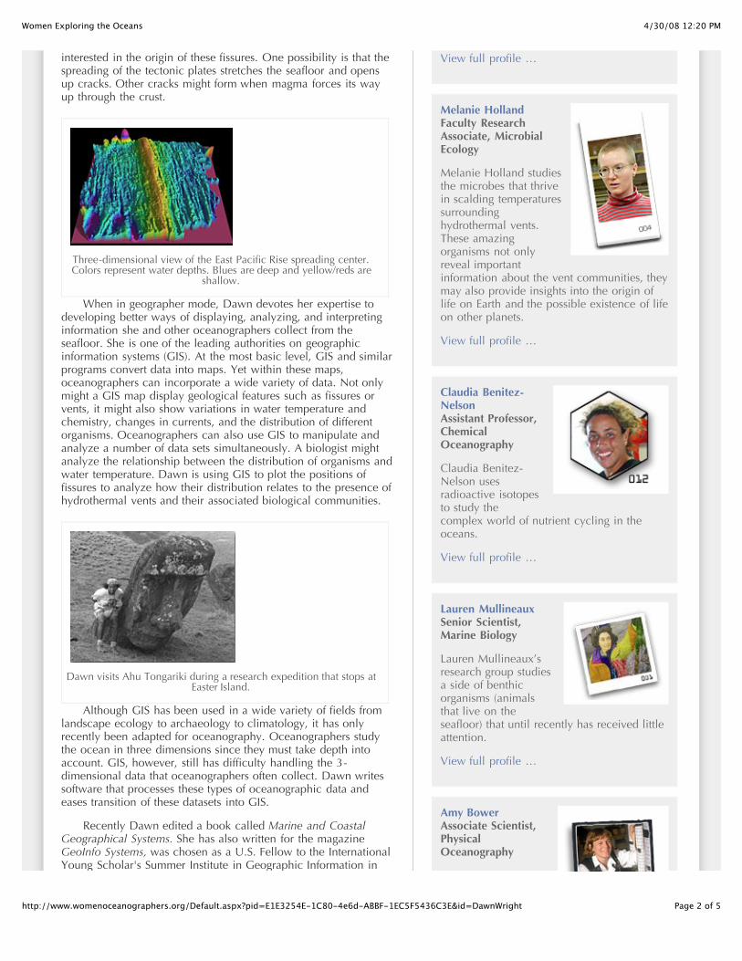
Three-dimensional view of the East Pacific Rise spreading center.Colors represent water depths. Blues are deep and yellow/reds are
shallow.
Dawn visits Ahu Tongariki during a research expedition that stops atEaster Island.
interested in the origin of these fissures. One possibility is that thespreading of the tectonic plates stretches the seafloor and opensup cracks. Other cracks might form when magma forces its wayup through the crust.
When in geographer mode, Dawn devotes her expertise todeveloping better ways of displaying, analyzing, and interpretinginformation she and other oceanographers collect from theseafloor. She is one of the leading authorities on geographicinformation systems (GIS). At the most basic level, GIS and similarprograms convert data into maps. Yet within these maps,oceanographers can incorporate a wide variety of data. Not onlymight a GIS map display geological features such as fissures orvents, it might also show variations in water temperature andchemistry, changes in currents, and the distribution of differentorganisms. Oceanographers can also use GIS to manipulate andanalyze a number of data sets simultaneously. A biologist mightanalyze the relationship between the distribution of organisms andwater temperature. Dawn is using GIS to plot the positions offissures to analyze how their distribution relates to the presence ofhydrothermal vents and their associated biological communities.
Although GIS has been used in a wide variety of fields fromlandscape ecology to archaeology to climatology, it has onlyrecently been adapted for oceanography. Oceanographers studythe ocean in three dimensions since they must take depth intoaccount. GIS, however, still has difficulty handling the 3-dimensional data that oceanographers often collect. Dawn writessoftware that processes these types of oceanographic data andeases transition of these datasets into GIS.
Recently Dawn edited a book called Marine and CoastalGeographical Systems. She has also written for the magazineGeoInfo Systems, was chosen as a U.S. Fellow to the InternationalYoung Scholar's Summer Institute in Geographic Information in
View full profile …
Melanie HollandFaculty ResearchAssociate, MicrobialEcology
Melanie Holland studiesthe microbes that thrivein scalding temperaturessurroundinghydrothermal vents.These amazingorganisms not onlyreveal importantinformation about the vent communities, theymay also provide insights into the origin oflife on Earth and the possible existence of lifeon other planets.
View full profile …
Claudia Benitez-NelsonAssistant Professor,ChemicalOceanography
Claudia Benitez-Nelson usesradioactive isotopesto study thecomplex world of nutrient cycling in theoceans.
View full profile …
Lauren MullineauxSenior Scientist,Marine Biology
Lauren Mullineaux’sresearch group studiesa side of benthicorganisms (animalsthat live on theseafloor) that until recently has received littleattention.
View full profile …
Amy BowerAssociate Scientist,PhysicalOceanography
Amy studies the

4/30/08 12:19 PMWomen Exploring the Oceans
Page 3 of 5http://www.womenoceanographers.org/Default.aspx?pid=E1E3254E-1C80-4e6d-ABBF-1EC5F5436C3E&id=DawnWright
Berlin, Germany, in 1996, and was profiled on BlackEntertainment Television's website. Currently she teaches threecourses in GIS.
Amy studies theinteractions betweenocean currents andclimate. Theseinteractions are verycomplex.
View full profile …
Kathryn GillisProfessor, Earth andOcean Sciences
Kathryn Gillis dives torifts in the seafloor thatare as deep as sixkilometers to learnabout the processestaking place within theocean crust.
View full profile …
Emily KleinProfessor of Geology,Geochemistry
Emily collects rocksfrom the deepseafloor. Thechemicals that makeup the rocks provideclues to how the oceanic crust is built.
View full profile …
Jo GriffithPrincipal Illustrator,Scientific andOceanographic Data
Technical illustrator JoGriffith hasn’t pickedup a pen in over fiveyears. Instead she usesa variety of computerprograms to creategraphs, maps, andillustrations forresearchers.
View full profile …
Debby RamseyThird Engineer,Marine Crew
4/30/08 12:19 PMWomen Exploring the Oceans
Page 4 of 5http://www.womenoceanographers.org/Default.aspx?pid=E1E3254E-1C80-4e6d-ABBF-1EC5F5436C3E&id=DawnWright
As Third Engineeronboard the ResearchVessel Thomas G.Thompson, DebbyRamsey helps keep allof the equipment that has moving partsrunning smoothly.
View full profile …
Maya TolstoyResearch Scientist,Geophysics
Marine seismologistMaya Tolstoy helpsfind activevolcanoes on theseafloor by listeningfor their eruptions.
View full profile …
Rose DufourShip Scheduler andClearance Officer,Ship Operations andMarine TechnicalSupport
Rose Dufour and herjob-share partnerElizabeth Brennercreate the schedules for four research ships.The challenge is to keep the scientists,funding agencies, and foreign governmentshappy.
View full profile …
Ashanti PyrtleAssistant Professor,Aquatic Science
Ashanti Pyrtle studiesthe fate of radioactivematerial that entersrivers, lakes, andoceans. She also advisesminority science students on how to navigatethrough graduate school and prepare for acareer afterwards.
View full profile …
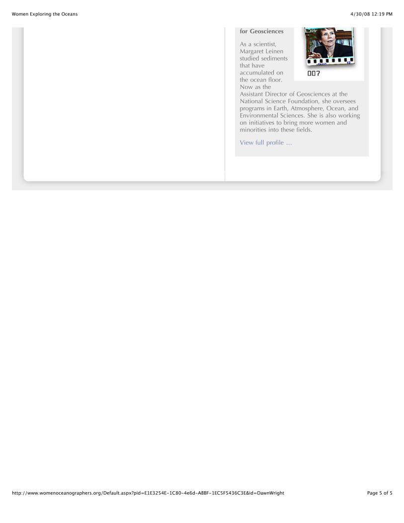
Margaret LeinenAssistant Director
4/30/08 12:19 PMWomen Exploring the Oceans
Page 5 of 5http://www.womenoceanographers.org/Default.aspx?pid=E1E3254E-1C80-4e6d-ABBF-1EC5F5436C3E&id=DawnWright
for Geosciences
As a scientist,Margaret Leinenstudied sedimentsthat haveaccumulated onthe ocean floor.Now as theAssistant Director of Geosciences at theNational Science Foundation, she overseesprograms in Earth, Atmosphere, Ocean, andEnvironmental Sciences. She is also workingon initiatives to bring more women andminorities into these fields.
View full profile …

4/30/08 12:20 PMWomen Exploring the Oceans
Page 1 of 5http://www.womenoceanographers.org/Default.aspx?pid=E1E3254E-1C80-4e6d-ABBF-1EC5F5436C3E&id=DawnWright
Home About Us Site Map XML/RSS
Dawn points out features on a map of theseafloor.
Dawn Wright (a.k.a. Deepsea Dawn) has immersed herself intwo disciplines. She is a geologist who studies the structures alongthe mid-ocean ridges--the volcanic mountain ranges and sites ofseafloor spreading that snake along the bottom of the oceansthousands of meters deep. These mid-ocean ridges are the sites ofhydrothermal vents and the unique ecosystems that the ventssupport. She is also a geographer who specializes in the softwareoceanographers of all disciplines use to map and analyze theseafloor.
When ingeologist mode,Dawn focuses oncracks (calledfissures) that formon the seaflooralong theseseafloor-spreadingcenters. Thesefissures, whichrange in widthfrom a few inchesto several feet, actas passageways
beneath the seafloor for magma (molten rock) rising from themantle and for seawater. Hydrothermal vents are created whenseawater percolates down through the cracks in the ocean crust,is heated by magma, then rises back though the cracks to thesurface. Therefore fissures provide important clues to the nature ofvolcanic eruptions and to the birth and death of hydrothermalvents.
To learn more about this seafloor "plumbing system", Dawnhas studied photos, videos, and sonar images of the seafloor takenby remotely operated vehicles such as ARGO II. She has alsodescended to the seafloor in the research submarine ALVIN toobserve and photograph these fissures firsthand. She is especially
Professor, Department of GeosciencesOregon State University
ProfileDawn's profile.InterviewRead an interview with Dawn.BackgroundGet more info on Dawn's background.Picture GallerySee images of Dawn at work.Learn MoreLearn more about Dawn's fieldDawn's CalendarSee Dawn's typical work week.Related LinksOther sites related to Dawn's career.
Wen-lu ZhuAssociate Scientist,Geology andGeophysics
Wen-lu Zhu studies theproperties of rocksfound deep in theocean crust byrecreating thoseconditions in the laboratory.
View full profile …
Kathryn KellyProfessor (Affiliate),PhysicalOceanography
Kathryn Kelly studieshow changing oceancurrents affect theclimate. And shedoes all of her research from the comfort ofher office.
4/30/08 12:20 PMWomen Exploring the Oceans
Page 2 of 5http://www.womenoceanographers.org/Default.aspx?pid=E1E3254E-1C80-4e6d-ABBF-1EC5F5436C3E&id=DawnWright
Three-dimensional view of the East Pacific Rise spreading center.Colors represent water depths. Blues are deep and yellow/reds are
shallow.
Dawn visits Ahu Tongariki during a research expedition that stops atEaster Island.
interested in the origin of these fissures. One possibility is that thespreading of the tectonic plates stretches the seafloor and opensup cracks. Other cracks might form when magma forces its wayup through the crust.
When in geographer mode, Dawn devotes her expertise todeveloping better ways of displaying, analyzing, and interpretinginformation she and other oceanographers collect from theseafloor. She is one of the leading authorities on geographicinformation systems (GIS). At the most basic level, GIS and similarprograms convert data into maps. Yet within these maps,oceanographers can incorporate a wide variety of data. Not onlymight a GIS map display geological features such as fissures orvents, it might also show variations in water temperature andchemistry, changes in currents, and the distribution of differentorganisms. Oceanographers can also use GIS to manipulate andanalyze a number of data sets simultaneously. A biologist mightanalyze the relationship between the distribution of organisms andwater temperature. Dawn is using GIS to plot the positions offissures to analyze how their distribution relates to the presence ofhydrothermal vents and their associated biological communities.
Although GIS has been used in a wide variety of fields fromlandscape ecology to archaeology to climatology, it has onlyrecently been adapted for oceanography. Oceanographers studythe ocean in three dimensions since they must take depth intoaccount. GIS, however, still has difficulty handling the 3-dimensional data that oceanographers often collect. Dawn writessoftware that processes these types of oceanographic data andeases transition of these datasets into GIS.
Recently Dawn edited a book called Marine and CoastalGeographical Systems. She has also written for the magazineGeoInfo Systems, was chosen as a U.S. Fellow to the InternationalYoung Scholar's Summer Institute in Geographic Information in
View full profile …
Melanie HollandFaculty ResearchAssociate, MicrobialEcology
Melanie Holland studiesthe microbes that thrivein scalding temperaturessurroundinghydrothermal vents.These amazingorganisms not onlyreveal importantinformation about the vent communities, theymay also provide insights into the origin oflife on Earth and the possible existence of lifeon other planets.
View full profile …
Claudia Benitez-NelsonAssistant Professor,ChemicalOceanography
Claudia Benitez-Nelson usesradioactive isotopesto study thecomplex world of nutrient cycling in theoceans.
View full profile …
Lauren MullineauxSenior Scientist,Marine Biology
Lauren Mullineaux’sresearch group studiesa side of benthicorganisms (animalsthat live on theseafloor) that until recently has received littleattention.
View full profile …
Amy BowerAssociate Scientist,PhysicalOceanography
Amy studies the
4/30/08 12:20 PMWomen Exploring the Oceans
Page 3 of 5http://www.womenoceanographers.org/Default.aspx?pid=E1E3254E-1C80-4e6d-ABBF-1EC5F5436C3E&id=DawnWright
Berlin, Germany, in 1996, and was profiled on BlackEntertainment Television's website. Currently she teaches threecourses in GIS.
Amy studies theinteractions betweenocean currents andclimate. Theseinteractions are verycomplex.
View full profile …
Kathryn GillisProfessor, Earth andOcean Sciences
Kathryn Gillis dives torifts in the seafloor thatare as deep as sixkilometers to learnabout the processestaking place within theocean crust.
View full profile …
Emily KleinProfessor of Geology,Geochemistry
Emily collects rocksfrom the deepseafloor. Thechemicals that makeup the rocks provideclues to how the oceanic crust is built.
View full profile …
Jo GriffithPrincipal Illustrator,Scientific andOceanographic Data
Technical illustrator JoGriffith hasn’t pickedup a pen in over fiveyears. Instead she usesa variety of computerprograms to creategraphs, maps, andillustrations forresearchers.
View full profile …
Debby RamseyThird Engineer,Marine Crew
4/30/08 12:20 PMWomen Exploring the Oceans
Page 1 of 5http://www.womenoceanographers.org/Default.aspx?pid=6C745379-31FC-4239-A350-6BE73835F0E9&id=DawnWright
Home About Us Site Map XML/RSS
What were some of the things that interested you as a child?How did you become interested in science?
I grew up in the Hawaiian Islands, which had a lot to do withmy interest in oceanography. I remember having very, very goodteachers who always encouraged us to read a lot. I really gotinterested in reading books about the sea. I started out readingTwenty Thousand Leagues Under the Sea, Mutiny on the Bounty,Treasure Island, anything that had to do with sea adventures. Iimagined myself as a pirate or adventurer. Then I thought, whynot consider doing something like this for real.
Another big factor was my mother. She was very encouraging.To this day she is always encouraging me in everything that I do.
TV was also abig influence. Yousee bumper stickersall the time tellingyou to kill yourtelevision, and I seetheir point. But I'mreally thankful for"The WonderfulWorld of Disney",NationalGeographic specials,and Jacques
Cousteau. My generation grew up with Jacques Cousteau whetherwe were interested in oceanography or not. There were so manyof his specials that were on TV Sunday nights. That had atremendous impact on me.
How did you go about pursuing your career?
By the time I was eight, I had pretty much decided to becomean oceanographer. I wasn't sure what kind of an oceanographer Iwas going to become. I wasn't sure whether I was going tobecome a scientist, an underwater photographer, or what. By highschool, I had read up on what oceanographers do. I was reallyinterested in geology. I really liked rocks and volcanoes, so Idecided to put myself on the path to geological oceanography.
In college, most people interested in oceanography major inone of the basic sciences, then study oceanography in graduateschool. I went off to a small Christian liberal arts college in Illinoisand majored in geology.
What did you do after college?
I went to Texas A&M University for my master's degree in
Professor, Department of GeosciencesOregon State University
ProfileDawn's profile.InterviewRead an interview with Dawn.BackgroundGet more info on Dawn's background.Picture GallerySee images of Dawn at work.Learn MoreLearn more about Dawn's fieldDawn's CalendarSee Dawn's typical work week.Related LinksOther sites related to Dawn's career.
Wen-lu ZhuAssociate Scientist,Geology andGeophysics
Wen-lu Zhu studies theproperties of rocksfound deep in theocean crust byrecreating thoseconditions in the laboratory.
View full profile …
Kathryn KellyProfessor (Affiliate),PhysicalOceanography
Kathryn Kelly studieshow changing oceancurrents affect theclimate. And shedoes all of her research from the comfort ofher office.
4/30/08 12:20 PMWomen Exploring the Oceans
Page 2 of 5http://www.womenoceanographers.org/Default.aspx?pid=6C745379-31FC-4239-A350-6BE73835F0E9&id=DawnWright
geological oceanography. People with a master's degree can do alot in oceanography. They can be technicians. They can beconsulting scientists on a lot of projects. But if you want to doyour own science projects and oversee oceanographicexpeditions--be the master or mistress of your own destiny -- youreally need a Ph.D.
So I decided to pursue a Ph.D. But first I wanted to take abreak and get some more experience. So I worked for three yearson a scientific ocean-drilling project as a marine technician. Itwas a great way to learn more about how ocean science works,how people on a ship interact, and the culture of science. By thetime I finished working with the Ocean Drilling Program, I wasable to think about which Ph.D. program I wanted to enter. Iended up at University of California, Santa Barbara. I wasactually in the geography program there and came out with ajoint degree in geography and marine geology. That’s where Ideveloped an interest in GIS (Geographical Information Systems)and in combining GIS with oceanographic work.
How did you get your current position at Oregon State?
I think I was at the right place at the right time. I was stillworking on my Ph.D. dissertation, and I got a call from OregonState inviting me to interview for a job. Apparently they had seenmy name and my thesis topic on a list in a newsletter. It was a listof either women students or minority students who were doingvarious things in geography.
I had to cancel the first interview because I was in amountain biking accident. I was so banged up I couldn’t makethe interview. That turned out to be even better for me becausethe students thought that that was so cool. To make a long storyshort, I was able to get a position here right out of graduateschool. I’ve been here for about five years. Things have workedout extremely well since they have a wonderful combination ofoceanographic studies and geography. They also have a lot goingon in terms of computer science, forestry, and a lot of really neatinterdisciplinary collaborations.
What is the mostsurprising thing aboutyour job?
Overall, I don’treally sense that I’mbeing discriminatedagainst or held backbecause I’m a womanor a woman of color.I’m just moving aheadto achieve and do thebest that I can likeanybody else in my
profession.
When you are at sea on an oceanographic research vessel,there’s a lot of physical work. For instance if you are trying todeploy equipment over the side it takes quite a bit of upper bodystrength. There have been times when a man would come by andtake something out of my hand or won’t have confidence that Ican do the job that I have been assigned to do. There can be two
View full profile …
Melanie HollandFaculty ResearchAssociate, MicrobialEcology
Melanie Holland studiesthe microbes that thrivein scalding temperaturessurroundinghydrothermal vents.These amazingorganisms not onlyreveal importantinformation about the vent communities, theymay also provide insights into the origin oflife on Earth and the possible existence of lifeon other planets.
View full profile …
Claudia Benitez-NelsonAssistant Professor,ChemicalOceanography
Claudia Benitez-Nelson usesradioactive isotopesto study thecomplex world of nutrient cycling in theoceans.
View full profile …
Lauren MullineauxSenior Scientist,Marine Biology
Lauren Mullineaux’sresearch group studiesa side of benthicorganisms (animalsthat live on theseafloor) that until recently has received littleattention.
View full profile …
Amy BowerAssociate Scientist,PhysicalOceanography
Amy studies the
4/30/08 12:20 PMWomen Exploring the Oceans
Page 3 of 5http://www.womenoceanographers.org/Default.aspx?pid=6C745379-31FC-4239-A350-6BE73835F0E9&id=DawnWright
reasons for that. One, the person might just be concerned for mysafety. The other side of the coin is that the person just doesn’tthink that I can do the job or that women do not belong at sea.That has happened to me at sea a couple of times. I think for atleast most of the women I have worked with who have faced thesame sorts of situations, we just keep doing our jobs the best thatwe can do. Ninety-nine percent of the time, at least in myexperience, we have been able to pull our weight and doextremely well at sea.
What continues to inspire you about your job?
There are lots of things. I am inspired by my colleagues.When I read about the advances my colleagues are making inscience, when someone discovers a new hydrothermal vent, findsa new way to calculate something, or makes a new discovery of avolcano, that’s really exciting. It spurs me on to keep striving withmy own research. I am particularly inspired by my colleagueswho are women. We do see quite a few women in sciencecompared to ten years ago, twenty years ago, and so forth, but it’sstill somewhat of a novelty seeing women achieving in certainareas. When one of us does well, I really like to see that.
I’m also inspired by my students and by the pleasure ofhaving had several very good graduate students who have goneon to do very good work and who now have great careers.
What are some of the other things you like to do?
I think that young people might get the impression thatscientists are lab rats, that we are in the lab all of the time.Perhaps I am giving that impression by talking about a 60-70 hourwork week. There are all kinds of wonderful things that scientistsdo in their spare time. I really enjoy cycling. I enjoy road andmountain biking. Here in the Pacific Northwest there is greathiking. A lot of my friends are into whitewater rafting andclimbing. I haven’t done a lot of those things yet, but I spend alot of my free time on my bicycle. I also enjoy building Lego's.Toys are something that carried over from my childhood. I have apirate ship in my office that is made out of 5,000 Lego pieces. Ittook me two weeks to build it. I really enjoy that for relaxation.
Do you have any advice for people considering a career inoceanography?
The trick I think is to keep that passion and excitement going.The way to maintain it is to have success, to do well in school,but also to have a balance of other interests. Keeping yourself awell-rounded person is a good recipe for success.
There is no escaping mathematics and gaining expertise withcomputers. Even if math isn’t your strongest subject, it’s a goodidea to stick with it and to do as well as you can and to really getas much experience as you can on computers. That’s a big part ofoceanography today. For me, GIS is all about computers. Even ifyou are not a computer geek, you need to have some wherewithalwith computers.
The last thing is to do as much personal research as you canabout oceanography. With the Internet, it’s so easy because youcan go to so many web sites. All of the institutions that specialize
Amy studies theinteractions betweenocean currents andclimate. Theseinteractions are verycomplex.
View full profile …
Kathryn GillisProfessor, Earth andOcean Sciences
Kathryn Gillis dives torifts in the seafloor thatare as deep as sixkilometers to learnabout the processestaking place within theocean crust.
View full profile …
Emily KleinProfessor of Geology,Geochemistry
Emily collects rocksfrom the deepseafloor. Thechemicals that makeup the rocks provideclues to how the oceanic crust is built.
View full profile …
Jo GriffithPrincipal Illustrator,Scientific andOceanographic Data
Technical illustrator JoGriffith hasn’t pickedup a pen in over fiveyears. Instead she usesa variety of computerprograms to creategraphs, maps, andillustrations forresearchers.
View full profile …
Debby RamseyThird Engineer,Marine Crew
As Third Engineer

4/30/08 12:20 PMWomen Exploring the Oceans
Page 4 of 5http://www.womenoceanographers.org/Default.aspx?pid=6C745379-31FC-4239-A350-6BE73835F0E9&id=DawnWright
in oceanography have great web sites. They’re great resources.The more personal research each person does, the better.
As Third Engineeronboard the ResearchVessel Thomas G.Thompson, DebbyRamsey helps keep allof the equipment that has moving partsrunning smoothly.
View full profile …
Maya TolstoyResearch Scientist,Geophysics
Marine seismologistMaya Tolstoy helpsfind activevolcanoes on theseafloor by listeningfor their eruptions.
View full profile …
Rose DufourShip Scheduler andClearance Officer,Ship Operations andMarine TechnicalSupport
Rose Dufour and herjob-share partnerElizabeth Brennercreate the schedules for four research ships.The challenge is to keep the scientists,funding agencies, and foreign governmentshappy.
View full profile …
Ashanti PyrtleAssistant Professor,Aquatic Science
Ashanti Pyrtle studiesthe fate of radioactivematerial that entersrivers, lakes, andoceans. She also advisesminority science students on how to navigatethrough graduate school and prepare for acareer afterwards.
View full profile …
Margaret LeinenAssistant Director
4/30/08 12:20 PMWomen Exploring the Oceans
Page 1 of 4http://www.womenoceanographers.org/Default.aspx?pid=F6460769-B069-4f9c-8319-3822DD30466F&id=DawnWright
Home About Us Site Map XML/RSS
Dawn Jeannine WrightProfessorDepartment of GeosciencesOregon State UniversityCorvallis, Oregon 97331-5506
Geography - Geographic information systems (GIS) and spatial analysis; marine geography; geography ofCyberspace; metadata; geographic information science in higher education.
Marine Geology - Fissuring, faulting, hydrothermal, and magmatic processes at mid-ocean ridges; volcanic-tectonic cycles and hydrothermal circulation; processing and interpretation of high-resolution deep-sea videoand photographic images.
1994 Ph.D., Geography and Marine Geology, University of California, Santa Barbara, CA1986 M.S., Oceanography, Texas A&M University, College Station, TX1983 B.A., cum laude, Geology, Wheaton College, Wheaton, IL
2002-present Professor, Department of Geosciences, Oregon State University1999-2002 Associate Professor, Department of Geosciences, Oregon State University1995-1999 Assistant Professor, Department of Geosciences, Oregon State UniversityJan 1995-Sept 1995 Post-doctoral Research Associate, NOAA-Pacific Marine Environmental Lab, Oregon State
University Hatfield Marine Science Center1990-1994 Graduate Student Researcher, Marine Science Institute and National Center for Geographic Information and
Analysis, University of California, Santa Barbara (UCSB)1986-1989 Marine Laboratory Specialist, Logistics and Technical Support, Ocean Drilling Program, Texas A&M
University1985-1986 Graduate Research Assistant, Science Operations, Ocean Drilling Program, Texas A&M University
2004 Fulbright Grant to Ireland, Senior Specialists Program in Information Technology, University College Cork, Coastaland Marine Resources Centre.
2001 Excellence in Mentoring Award, OSU College of Oceanic and Atmospheric Sciences.1999 Biography featured in Portraits of Great American Scientists, edited by 1988 Nobel Laureate in Physics, Leon M.
Lederman, and Judith Scheppler of the Illinois Mathematics and Science Academy, published by PrometheusBooks.
1999 Woman of the Year in education; selected by Clarity Magazine, a Guideposts publication for women.1999 Outstanding Professor Award, OSU University Honors College1999 Invited presentation at TED (Technology, Entertainment, Design), a prestigious, "wildly eclectic conference of
remarkable thinkers and doers."1998 Excellence in Mentoring Award, OSU College of Oceanic and Atmospheric Sciences1997 U.S. Fellow, RIDGE/Nordic Volcanological Institute Summer School on Active Processes at Mid-Ocean Ridges,
Lake Myvatn, Iceland1997 Listing in 20th edition of American Men & Women of Science (AMWS), a biographical directory of today's leaders
in physical, biological and related sciences, R.R. Bowker Publisher1996 U.S. Fellow, International Young Scholar's Summer Institute in Geographic Information, Berlin, Germany
4/30/08 12:20 PMWomen Exploring the Oceans
Page 2 of 4http://www.womenoceanographers.org/Default.aspx?pid=F6460769-B069-4f9c-8319-3822DD30466F&id=DawnWright
1995 Faculty Early Career Development Award (formerly the Presidential Young Investigator Award), National ScienceFoundation
1995 UCSB Graduate Division Commencement Speaker Competition, Finalist1993-1994 Ford Foundation Dissertation Fellowship, National Research Council1990-1993 University of California President's Fellowship1991 Environmental Systems Research Institute Student Assistantship1987 Phi Kappa Phi1983-1985 Texas A&M University Minority Merit Fellowship1980-1984 American Geological Institute Scholarships & American Geophysical Union "Sea Scholar" Designations1983 National Science Foundation Graduate Fellowship, Honorable Mention1982 National Dean's List1982 Wheaton College Alumni Association Senior Scholarship for "Outstanding Christian Character, Citizenship,
Contribution to Campus Life and Grade Point Average"1979 Robert H. Ogle Scholarship, Alpha Phi Alpha Fraternity, for "Outstanding Proficiency in Athletics Combined with
Excellence in Scholarship"
2004 Wright D.J., Coastal mapping and charting, Geospatial Solutions, 14(9): 20.2004 Wepner, G., D.J. Wright, C.J. Merry, S.J. Anderson, and S.D. DeGloria. Remotely-acquired data and information in
GIScience, in McMaster, R. and Usery, L. (eds.), A Research Agenda for Geographic Information Science, BocaRaton, Florida: CRC Press LLC, 351-364.
2004 Mayer, L., Barbor, K., Boudreau, P., Chance, T., Fletcher, C., Greening, H., Li, R., Mason, C., Metcalf, K., Snow-Cotter, S., and Wright, D., A Geospatial Framework for the Coastal Zone: National Needs for Coastal Mappingand Charting, Washington, DC: National Academies Press, 149 pp.
2004 Psuty, N.P., Steinberg, P., and Wright, D.J., Coastal and marine geography, in Gaile, G.L. and Willmott, C.J. (Eds.)Geography in America at the Dawn of the 21st Century , New York: Oxford University Press, 314-325.
2004 Wright, D.J., Marine geography in support of "reefs at risk", in Warf, B., Janelle, D., and Hansen, K., (eds.),WorldMinds: Geographical Perspectives on 100 Problems, New York: Kluwer Academic Publishers, 325-330.
2003 Wright, D.J., O'Dea, E., Cushing, J.B., Cuny, J.E., a nd Toomey, D.R., Why Web GIS may not be enough: A casestudy with the Virtual Research Vessel, Marine Geodesy, 26(1-2), 73-86.
2003 Wright, D.J. Internet GIS at Oregon State University, in Peng, Z.R. and Tsou, M.H., Internet GIS: A DistributedGeospatial Information Service for Wired and Wireless Networks, New York: John Wiley and Sons, 198-199.
2003 Wright, D.J., Review of Geographic Information Systems in Oceanography and Fisheries by V.D. Valavanis,London: Taylor & Francis, 209 pp., ISBN 0-415-28463-5, International Journal of Geographical InformationScience, 17(6): 599-600.
2002 Wright, D.J., Haymon, R.M., White, S.M., and Macdonald, K.C., Crustal fissuring on the crest of the southern EastPacific Rise, 17° 15'-40'S, Journal of Geophysical Research, 10.1029/2001JB000544, 2002.
2002 Rub, M.W., D. Wright, and J. Jones, A novel landscape ecology approach for determining microhabitatcorrelations and faunal patchiness in extreme environments: Pilot study for the southern East Pacific Rise at 17-18° S, CBM-Cahiers de Biologie Marine, 43: 307-311.
2002 Wright, D.J. (ed.), Undersea with GIS, Redlands, CA: ESRI Press, 2002, 253 pp. plus companion CD-ROM.2002 Wright, D.J., Introduction, in D.J. Wright (Ed.), Undersea with GIS, Redlands, California, ESRI Press, xiii-xx.2002 Wright, D.J., B.T. Donahue, and D.F. Naar, Seafloor mapping and GIS coordination at America's remotest national
marine sanctuary (American Samoa), in D.J. Wright (Ed.), Undersea with GIS, Redlands, California, ESRI Press,33-63.
2002 Wright, D.J., Selected bibliography and Internet resources, in D.J. Wright (Ed.), Undersea with GIS, Redlands,California, ESRI Press, 245-253.
2002 Wright, D.J., Mapping the Seafloor in American Samoa, Geospatial Solutions, 12(7): 24-25.2002 Wright, D., D. DiBiase, C. Pancake, R. Wright, and K. Foote. Challenges and opportunities in distance education
for geographic information science, University Consortium for Geographic Information Science Special WhitePaper, 20 manuscript pages.
2002 Wright, D.J., Towards a data management infrastructure for MARGINS: Examples from Boomerang 8 and theVirtual Research Vessel [pdf], MARGINS Newsletter, 9:34-36, 38.
2002 Breman, J., D. Wright, and P. Halpin, The inception of the ArcGIS marine data model, in Breman, J. (ed.), MarineGeography, Redlands, California, ESRI Press, 3-9.
2002 Nasby, N., Embley, R., Hixon, M., Merle, S., Tissot, B., and Wright, D., Integration of submersible transect dataand high-resolution sonar imagery for a habitat-based groundfish assessment of Heceta Bank, Oregon, FisheriesBulletin, 100: 739-751.
2002 Walsh, K., C. Pancake, D.J. Wright, S. Haerer, and J. Hanus, "Humane" interfaces to improve the usability of data
4/30/08 12:20 PMWomen Exploring the Oceans
Page 3 of 4http://www.womenoceanographers.org/Default.aspx?pid=F6460769-B069-4f9c-8319-3822DD30466F&id=DawnWright
clearinghouses, in Egenhofer, M. and Mark, D. (eds.), GIScience 2002, Lecture Notes in Computer Science2478, Berlin: Springer-Verlag, 333-345.
2001 Smith, D., S. Carbotte, S. Cande, S. Miller, D. Wright, and W. Ryan, Data Management for Marine Geology andGeophysics: Tools for Archiving, Analysis, and Visualization [pdf], NSF/ONR Workshop Report, GeosciencesProfessional Services, Inc., Washington, D.C., 32 pp.
2000 Wright, D.J., Bloomer, S.H., MacLeod, C.J., Taylor, B., and Goodliffe, A.M., Bathymetry of the Tonga Trench andforearc: A map series, Marine Geophysical Researches, 21(5): 489-512, 2000.
2000 Wilson, J.P., Mitasova, H., and Wright, D.J., Water resource applications of GIS, Journal of the Urban and RegionalInformation Systems Association, 12(2): 61-79.
2000 Tivey, M.K., Bemis, K., Bradley, A.M., Butterfield, J., Delaney, J.R., Ding, K., Dziak, R.P., Fisher, C., Fox, C.G.,Hautala, S., Jackson, D., Jannasch, H.W., Johnson, H.P., Juniper, S.K., Kadko, D., Kelley, D.S., Lilley, M.,McDuff, R.E., Rona, P., Sarrazin, J., Schultz, A., Seyfried, W.E., Jr., Thomson, R.E., Wheat, C.G., Wilcock, W.,Wright, D., and Yoerger, D., The RIDGE Endeavour Segment seafloor observatory: Recent successes and anoverview of coordinated experiments for Y2K, RIDGE Events, 11(1): 10-17, 2000.
1999 Wright, D.J. and Bartlett, D.J. (Eds.), Marine and Coastal Geographical Information Systems, London: Taylor &Francis, 320 pp.
1999 Wright, D.J., Down to the sea in ships: The emergence of marine GIS, in Wright, D.J. and Bartlett, D.J. (eds.),Marine and Coastal Geographical Information Systems, London: Taylor & Francis, 1-10.
1999 Wright, D.J., Spatial reasoning for marine geology and geophysics, in Wright, D.J. and Bartlett, D.J. (eds.), Marineand Coastal Geographical Information Systems, London: Taylor & Francis, 117-128.
1999 Bartlett, D.J. and Wright, D.J., Epilogue, in Wright, D.J. and Bartlett, D.J. (eds.), Marine and Coastal GeographicalInformation Systems, London: Taylor & Francis, 295-315.
1999 Wright, D.J. and Bartlett, D.J., Preface, in Wright, D.J. and Bartlett, D.J. (eds.), Marine and Coastal GeographicalInformation Systems, London: Taylor & Francis, xvii-xviii.
1999 Wright, D.J., Getting to the bottom of it: Tools, techniques, and discoveries of deep ocean geography, TheProfessional Geographer, 51(3): 426-439.
1999 Wright, D. J., Semantic modelling for oceanographic data in Craglia, M. A and Onsrud, H. (Eds.), GeographicInformation Research: Trans-Atlantic Perspectives, London: Taylor and Francis, 405-414.
1999 Wright, D.J., "Virtual" seminars in GIS: Academic future or flash in the pan?, Geo Info Systems, 9(3): 22, 24-26.1999 White, S.M., Macdonald, K.C., Haymon, R.M. and the Sojourn-2 Science Party (S. Baron, B. Bezy, E. Birk, L.
Crowder, G. Levai , L. Magde, J. O'Neill, D. Schierer, P. Sharfstein, S. Sudarikov, D. Wright), 1999, Volcanoesof the southern East Pacific Rise: A new view of crustal accretion and ridge segmentation at super-fastspreading rates, RIDGE Events, 10(2): 16-22.
1998 Wright, D.J., Formation and development of fissures at the East Pacific Rise: Implications for faulting andmagmatism at mid-ocean ridges, in Buck, W.R., Delaney, P., Karson, J. A., and Lagabrielle, Y. (Eds.), Faultingand Magmatism at Mid-Ocean Ridges, Geophysical Monograph 106, Washington, D.C: American GeophysicalUnion, 137-151.
1998 Wright, D.J., Wood, R., Sylvander, B., ArcGMT: A suite of tools for conversion between Arc/INFO and GenericMapping Tools (GMT), Computers and Geosciences, 24(8):737-744.
1998 Clift, P.D., MacLeod, C.J., Tappin, D.R., Wright, D.J., and Bloomer, S.H. Tectonic controls on sedimentation in theTonga Trench and Forearc, SW Pacific. Geol. Soc. Am. Bull., 110(4):483-496 + Front Cover.
1998 Wright, D.J. and McDuff, R., A geographic information system for the Endeavour Segment, RIDGE Events, 9(1):11-15.
1998 Wright, D.J., Creatures of the deep and maps of the ocean floor, Association for Women in Science Magazine,27(2):10-12.
1997 Wright, D.J., Goodchild, M.F., and Proctor, J.D., Demystifying the persistent ambiguity of GIS as "tool" versus"science", The Annals of the AAG, 87(2): 346-362.
1997 Wright, D.J., Goodchild, M.F., and Proctor, J.D., Reply: Hoping to turn that theoretical corner, The Annals of theAAG, 87(2): 373.
1997 Wright, D.J., Fox, C.G., Bobbitt, A.M., A scientific information model for deepsea mapping and sampling, MarineGeodesy, 20(4): 367-379.
1997 Wright, D. J., and Goodchild, M.F., Data from the deep: Implications for the GIS community, Int. J. GeographicalInformation Science, 11(6): 523-528.
1996 Wright, D.J., Rumblings on the ocean floor: GIS supports deep-sea research, Geo Info Systems, 6(1):22-29 + FrontCover.
1996 Wright, D.J., Aboard Alvin submersible: ArcView supports sea floor exploration, ARC News, 18(1):14.1996 Scheirer, D. S., Macdonald, K. C., Forsyth, D. W., Miller, S. P., Wright, D. J., and Cormier, M.-H., A map series of
the southern East Pacific Rise and its flanks, 15°S to 19°S, Mar. Geophys. Res., 18, 1-12.1995 Wright, D.J., Haymon, R.M., and Macdonald, K.C., Breaking new ground: Estimates of crack depth along the axial
zone of the East Pacific Rise (9° 12'-54'N) Earth Planet. Sci. Lett., 134:441-457.
4/30/08 12:20 PMWomen Exploring the Oceans
Page 4 of 4http://www.womenoceanographers.org/Default.aspx?pid=F6460769-B069-4f9c-8319-3822DD30466F&id=DawnWright
1995 Wright, D.J., Haymon, R.M., and Fornari, D.J., Crustal fissuring and its relationship to magmatic and hydrothermalprocesses on the East Pacific Rise crest (9° 12' - 54'N), J. Geophys. Res., 100(B4):6097-6210.
1994 Wright, D. J., Geographic information systems for RIDGE research, RIDGE Events, 5(2):5-7, 11.1994 Wright, D. J., From pattern to process on the deep ocean floor: A geographic information system approach, Ph.D.
dissertation, University of Califonia, Santa Barbara, CA, 341 pp.1993 Scheirer, D. S., K. Macdonald, D. Forsyth, R. Alexander, T. Atwater, N. Beedle, M. Cormier, K. Feldman, C.
Hollinshead, D. Levitt, M. A. Lynch, S. Miller, A. Padgett, A. Sauter, K. Sayanagi, Y. Shen, C. Weiland, and D.Wright, Wide-spread volcanic and tectonic activity on the southern East Pacific Rise and its flanks, RIDGEEvents, 4(1): 1-2, 8-9.
1993 Haymon, R. M., D. J. Fornari, K. L. Von Damm, M. D. Lilley, M. R. Perfit, J. M. Edmond, W. C. Shanks III, R. A.Lutz, J. B. Grebmeier, S. Carbotte, D. Wright, E. McLaughlin, E. Smith, N. Beedle, and E. Olson, Volcaniceruption of the mid-ocean ridge along the East Pacific Rise crest at 9°45-52'N: 1. Direct submersibleobservations of seafloor phenomena associated with an eruption event in April, 1991, Earth Planet. Sci. Lett.,109, 85-101.
1992 Wright, D. J., Convergence and strike-slip motion at the northern terminus of the Tonga Trench, Southwest Pacific,in CRC Handbook of Geophysical Exploration at Sea, edited by R. Geyer, p. 35-79, CRC Press, Boca Raton,Florida.
1992 Wright, D. J., and R. M. Haymon, Applications of ARC/INFO to the studies of the ocean floor, in ARC/INFO Maps1991, edited by J. Dangermond, p. 28-29, Environmental Systems Research Institute, Redlands, California.
1992 Haymon, R., D. Fornari, R. Lutz, K. Von Damm, M. Perfit, M. Lilley, W. C. I. Shanks, K. Macdonald, M. Edwards,D. Nelson, D. Colodner, M. Kappus, D. Wright, M. Black, D. Scheirer, H. Edmonds, E. Olson, and T.Geiselman, 1991 eruption site on the East Pacific Rise at 9°45'-52'N is evolving rapidly: Results of AdVenture'92 dive series, RIDGE Events, 3(2), 1- 2, 11.
1991 Haymon, R. M., D. J. Fornari, M. H. Edwards, S. Carbotte, D. Wright, and K. C. Macdonald, Hydrothermal ventdistribution along the East Pacific Rise Crest (9°09'- 54'N) and its relationship to magmatic and tectonicprocesses on fast-spreading mid-ocean ridges, Earth Planet. Sci. Lett., 104, 513-534.
1991 Haymon, R. M., S. Carbotte, D. Wright, N. Beedle, F. Johnson, D. J. Fornari, K. Von Damm, J. Grebmeier, M.Lilley, E. McLaughlin, E. Olson, J. Edmond, M. R. Perfit, M. Smith, W. C. Shanks III, R. Lutz, J. Seewald, and D.Reudelhuber, Active eruption seen on East Pacific Rise, Eos Trans. AGU, 72, 505-507.
1991 Haymon, R. M., D. Fornari, K. Von Damm, J. Edmond, M. Lilley, M. Perfit, W. C. Shanks III, J. Grebmeier, R.Lutz, S. Carbotte, D. Wright, M. Smith, E. McLaughlin, N. Beedle, J. Seewald, D. Reudelhuber, E. Olson, and F.Johnson, East Pacific Rise erupts north of Leg 142 drillsite!, JOI-USSAC Newsletter, 4, 4-12.
Cycling (former collegiate and United States Cycling Federation licensed racer)Peanuts Comic Strip CollectiblesIndependent FilmsFilm AnimationNative American RightsTravels in Australia, Barbados, Canada, Chile, Denmark, Easter Island, Fiji, France, Germany, Guam, Honduras, Hong
Kong, Japan, Kenya, Mauritius, Mexico, the Netherlands, New Zealand, Samoan islands, Singapore, Sri Lanka,Tahiti, the United Kingdom and most of the USA
4/30/08 12:20 PMWomen Exploring the Oceans
Page 1 of 3http://www.womenoceanographers.org/Default.aspx?pid=28EF75D5-D130-46c0-947E-5CCBC627B0EE&id=DawnWright
Home About Us Site Map XML/RSS
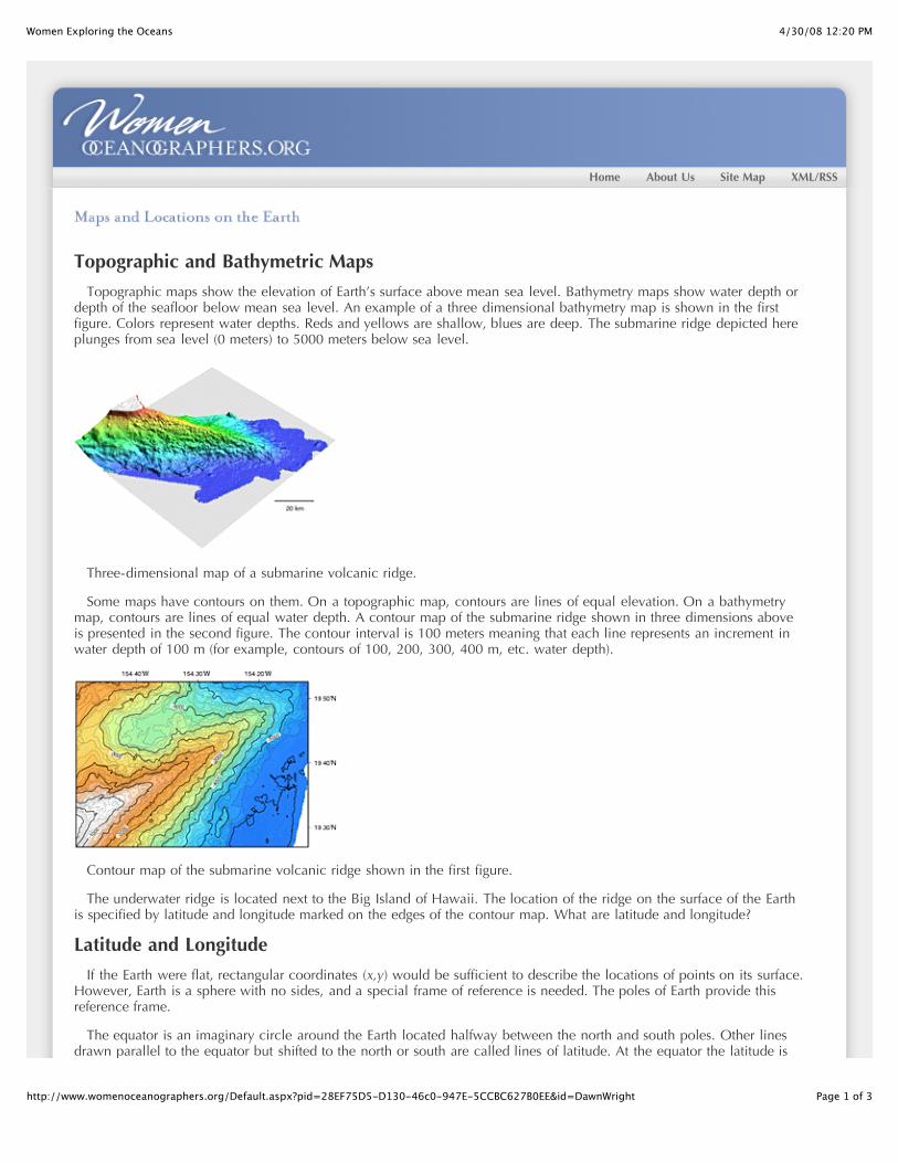
Topographic and Bathymetric Maps
Topographic maps show the elevation of Earth’s surface above mean sea level. Bathymetry maps show water depth ordepth of the seafloor below mean sea level. An example of a three dimensional bathymetry map is shown in the firstfigure. Colors represent water depths. Reds and yellows are shallow, blues are deep. The submarine ridge depicted hereplunges from sea level (0 meters) to 5000 meters below sea level.
Three-dimensional map of a submarine volcanic ridge.
Some maps have contours on them. On a topographic map, contours are lines of equal elevation. On a bathymetrymap, contours are lines of equal water depth. A contour map of the submarine ridge shown in three dimensions aboveis presented in the second figure. The contour interval is 100 meters meaning that each line represents an increment inwater depth of 100 m (for example, contours of 100, 200, 300, 400 m, etc. water depth).
Contour map of the submarine volcanic ridge shown in the first figure.
The underwater ridge is located next to the Big Island of Hawaii. The location of the ridge on the surface of the Earthis specified by latitude and longitude marked on the edges of the contour map. What are latitude and longitude?
Latitude and Longitude
If the Earth were flat, rectangular coordinates (x,y) would be sufficient to describe the locations of points on its surface.However, Earth is a sphere with no sides, and a special frame of reference is needed. The poles of Earth provide thisreference frame.
The equator is an imaginary circle around the Earth located halfway between the north and south poles. Other linesdrawn parallel to the equator but shifted to the north or south are called lines of latitude. At the equator the latitude is
4/30/08 12:20 PMWomen Exploring the Oceans
Page 2 of 3http://www.womenoceanographers.org/Default.aspx?pid=28EF75D5-D130-46c0-947E-5CCBC627B0EE&id=DawnWright
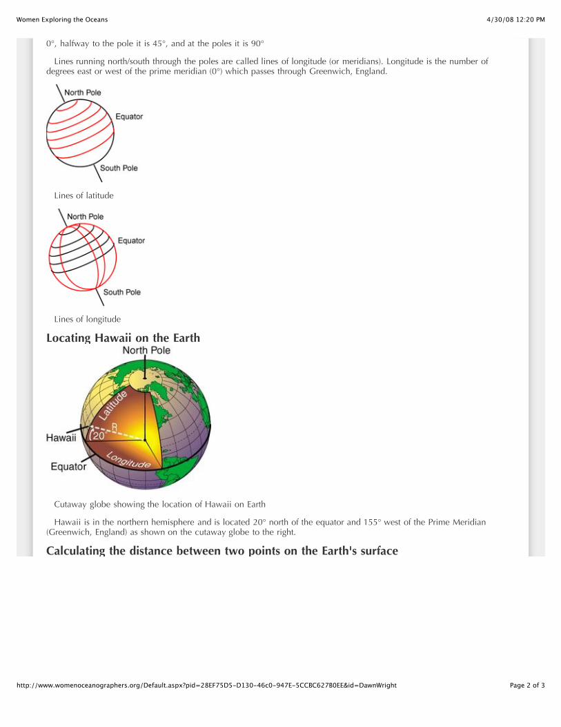
0°, halfway to the pole it is 45°, and at the poles it is 90°
Lines running north/south through the poles are called lines of longitude (or meridians). Longitude is the number ofdegrees east or west of the prime meridian (0°) which passes through Greenwich, England.
Lines of latitude
Lines of longitude
Locating Hawaii on the Earth
Cutaway globe showing the location of Hawaii on Earth
Hawaii is in the northern hemisphere and is located 20° north of the equator and 155° west of the Prime Meridian(Greenwich, England) as shown on the cutaway globe to the right.
Calculating the distance between two points on the Earth's surface
4/30/08 12:20 PMWomen Exploring the Oceans
Page 3 of 3http://www.womenoceanographers.org/Default.aspx?pid=28EF75D5-D130-46c0-947E-5CCBC627B0EE&id=DawnWright
Calculating the distance between two points on the Earth's surface
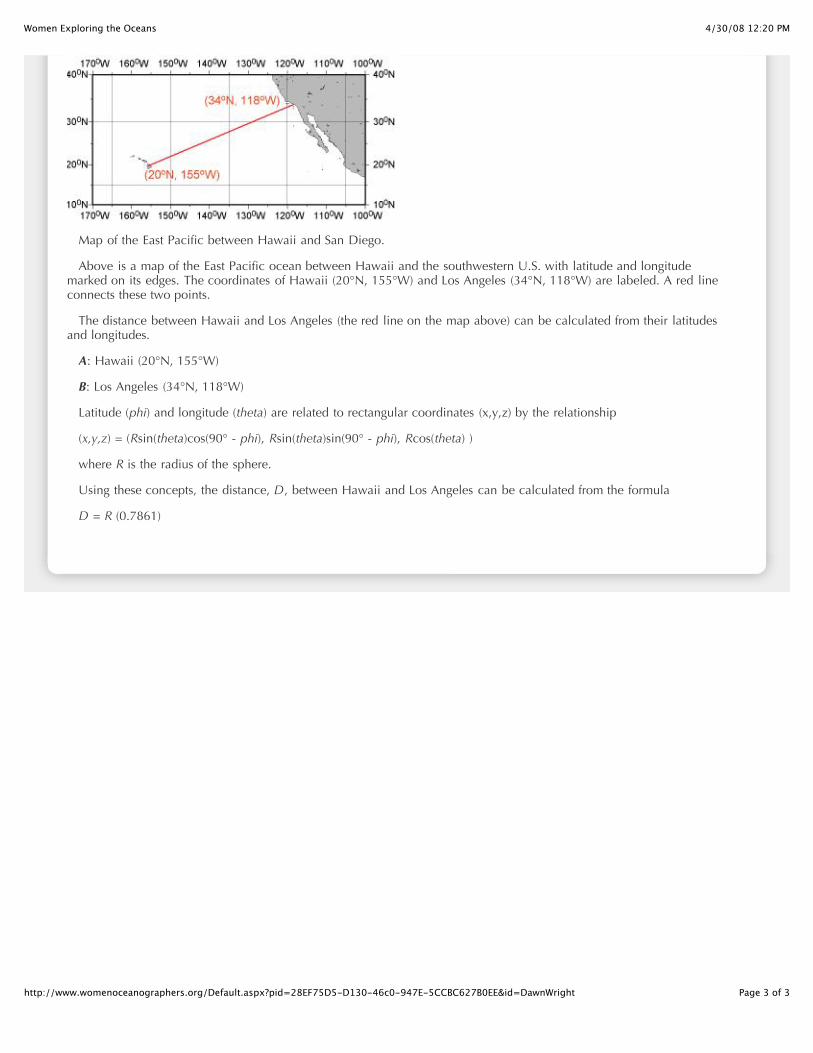
Map of the East Pacific between Hawaii and San Diego.
Above is a map of the East Pacific ocean between Hawaii and the southwestern U.S. with latitude and longitudemarked on its edges. The coordinates of Hawaii (20°N, 155°W) and Los Angeles (34°N, 118°W) are labeled. A red lineconnects these two points.
The distance between Hawaii and Los Angeles (the red line on the map above) can be calculated from their latitudesand longitudes.
A: Hawaii (20°N, 155°W)
B: Los Angeles (34°N, 118°W)
Latitude (phi) and longitude (theta) are related to rectangular coordinates (x,y,z) by the relationship
(x,y,z) = (Rsin(theta)cos(90° - phi), Rsin(theta)sin(90° - phi), Rcos(theta) )
where R is the radius of the sphere.
Using these concepts, the distance, D, between Hawaii and Los Angeles can be calculated from the formula
D = R (0.7861)
4/30/08 12:20 PMWomen Exploring the Oceans
Page 1 of 5http://www.womenoceanographers.org/Default.aspx?pid=5B767BBA-799C-4a8a-9E95-F02244C80C85&id=DawnWright
Home About Us Site Map XML/RSS
Dawn points out features on a map.
9:00Workout out in campusrec center (weights andexercise bike).10:15Respond to emails andphone calls11:00Teach Honors section ofan IntroductoryOceanography class(lasts 50 minutes, 6students). OSU has a
special Honors College for its best undergraduate students.12:15
Meet with graduate teaching assistants for my regularIntroductory Oceanography class and my Advanced GISclass.
1:00Teach regular Introductory Oceanography class(http://dusk.geo.orst.edu/oceans, lasts 50 minutes, 250students).
2:00Office hour and lunch.
3:00Respond to emails and phone calls.
4:30Take dog for a walk. Dawn's dog, Lydia, comes to campuswith her every day and has special permission to hang outin her building.
5:00Prepare for evening lecture.
6:00Teach Advanced Geographic Information Systems class(http://dusk.geo.orst.edu/buffgis, lasts an hour and a half,25 students).
7:30Prepare lectures/activities for next classes and/or try to get
Professor, Department of GeosciencesOregon State University
ProfileDawn's profile.InterviewRead an interview with Dawn.BackgroundGet more info on Dawn's background.Picture GallerySee images of Dawn at work.Learn MoreLearn more about Dawn's fieldDawn's CalendarSee Dawn's typical work week.Related LinksOther sites related to Dawn's career.
Wen-lu ZhuAssociate Scientist,Geology andGeophysics
Wen-lu Zhu studies theproperties of rocksfound deep in theocean crust byrecreating thoseconditions in the laboratory.
View full profile …
Kathryn KellyProfessor (Affiliate),PhysicalOceanography
Kathryn Kelly studieshow changing oceancurrents affect theclimate. And shedoes all of her research from the comfort ofher office.

4/30/08 12:20 PMWomen Exploring the Oceans
Page 2 of 5http://www.womenoceanographers.org/Default.aspx?pid=5B767BBA-799C-4a8a-9E95-F02244C80C85&id=DawnWright
Three-dimensional view of a volcano on theseafloor.
Dawn on the beach with her dog Lydia.
research or writing done, depending on deadlines.
10:00Workout incampus reccenter(weights).11:00Road ormountain bikeride if weatherallows.1:00Lunch.2:00Respond toemails and
phone calls.4:00
Attend Geography seminar - held every Tuesday at 4 p.m.(our department also holds Geology seminars everyThursday at 4 p.m.).
5:00Try to get research or writing done, depending ondeadlines.
Rest day from gymworkout out in campusrec center.
9:30Respond to emails andphone calls.11:00Teach Honors section ofan IntroductoryOceanography class(lasts 50 minutes, 6students).12:00
Respond to emails and lunch.1:00
Teach regular Introductory Oceanography class (lasts 50minutes, 250 students).
2:00Office hour.
3:00Attend Geoscience faculty or committee meeting. Scientistsin the department meet to talk about departmental issuesevery month on Wednesdays for a faculty meeting, or onother Wednesdays for various committee meetings(depending on the need).
5:00Take dog for a walk.
5:30Prepare for evening lecture.
6:00Teach Advanced Geographic Information Systems class,discussion sessions outside on the grass if weather allows
View full profile …
Melanie HollandFaculty ResearchAssociate, MicrobialEcology
Melanie Holland studiesthe microbes that thrivein scalding temperaturessurroundinghydrothermal vents.These amazingorganisms not onlyreveal importantinformation about the vent communities, theymay also provide insights into the origin oflife on Earth and the possible existence of lifeon other planets.
View full profile …
Claudia Benitez-NelsonAssistant Professor,ChemicalOceanography
Claudia Benitez-Nelson usesradioactive isotopesto study thecomplex world of nutrient cycling in theoceans.
View full profile …
Lauren MullineauxSenior Scientist,Marine Biology
Lauren Mullineaux’sresearch group studiesa side of benthicorganisms (animalsthat live on theseafloor) that until recently has received littleattention.
View full profile …
Amy BowerAssociate Scientist,PhysicalOceanography
Amy studies the
4/30/08 12:20 PMWomen Exploring the Oceans
Page 3 of 5http://www.womenoceanographers.org/Default.aspx?pid=5B767BBA-799C-4a8a-9E95-F02244C80C85&id=DawnWright
Marine and Coastal GIS poster outside Dawn'soffice.
Dawn on her bicycle.
(lasts an hour and a half, 25 students).7:30
Prepare lectures/activities for next classes and/or try to getresearch or writing done, depending on deadlines.
10:00Workout incampus reccenter(weights).11:00Teach HonorsOceanographylab (lasts 2hours).1:00 - 2:00Lunch.Respond toemails andphone calls.
4:00Work on web sites and logistics for an upcoming nationalconference of the University Consortium for GeographicInformation Science (UCGIS, http://www.ucgis.org). Dawnis the local arrangements chair for the conference andserves as a delegate, communications chair, and educationcommittee member for the UCGIS.
5:00Meeting in Dawn's lab, Davey Jones Locker, with all hergraduate students to track their progress and address any oftheir questions or concerns. Cookies and/or chips andsalsa.
6:00Respond to emails, try to get research or writing done.
9:00Workout out in campusrec center (weights andexercise bike).10:15Respond to emails andphone calls.11:00Teach Honors section ofan IntroductoryOceanography class(lasts 50 minutes, 6students).
12:00Respond to emails.
1:00Teach regular Introductory Oceanography class.
2:00Lunch and take dog for walk.
3:00Work on research proposals in progress so Dawn can goon more expeditions and do more neat research.
4:00Attend a staff meeting for Virtual Oregon, a new project
Amy studies theinteractions betweenocean currents andclimate. Theseinteractions are verycomplex.
View full profile …
Kathryn GillisProfessor, Earth andOcean Sciences
Kathryn Gillis dives torifts in the seafloor thatare as deep as sixkilometers to learnabout the processestaking place within theocean crust.
View full profile …
Emily KleinProfessor of Geology,Geochemistry
Emily collects rocksfrom the deepseafloor. Thechemicals that makeup the rocks provideclues to how the oceanic crust is built.
View full profile …
Jo GriffithPrincipal Illustrator,Scientific andOceanographic Data
Technical illustrator JoGriffith hasn’t pickedup a pen in over fiveyears. Instead she usesa variety of computerprograms to creategraphs, maps, andillustrations forresearchers.
View full profile …
Debby RamseyThird Engineer,Marine Crew
4/30/08 12:20 PMWomen Exploring the Oceans
Page 4 of 5http://www.womenoceanographers.org/Default.aspx?pid=5B767BBA-799C-4a8a-9E95-F02244C80C85&id=DawnWright
that Dawn is leading to establish a data center at OregonState for natural resources and environmental data ofOregon (including oceanographic data off the Oregoncoast).
8:00Attend a movie or community discussion group inCorvallis. Dawn enjoys watching independent films anddiscussing them afterwards with a group at the LogosHouse Christian Student Center, or participating indiscussions about challenges to women and minorities aspart of the community lecture series called "Beyond BlackHistory Month".
As Third Engineeronboard the ResearchVessel Thomas G.Thompson, DebbyRamsey helps keep allof the equipment that has moving partsrunning smoothly.
View full profile …
Maya TolstoyResearch Scientist,Geophysics
Marine seismologistMaya Tolstoy helpsfind activevolcanoes on theseafloor by listeningfor their eruptions.
View full profile …
Rose DufourShip Scheduler andClearance Officer,Ship Operations andMarine TechnicalSupport
Rose Dufour and herjob-share partnerElizabeth Brennercreate the schedules for four research ships.The challenge is to keep the scientists,funding agencies, and foreign governmentshappy.
View full profile …
Ashanti PyrtleAssistant Professor,Aquatic Science
Ashanti Pyrtle studiesthe fate of radioactivematerial that entersrivers, lakes, andoceans. She also advisesminority science students on how to navigatethrough graduate school and prepare for acareer afterwards.
View full profile …
Margaret LeinenAssistant Director
4/30/08 12:21 PMWomen Exploring the Oceans
Page 1 of 5http://www.womenoceanographers.org/Default.aspx?pid=D1CC0FEB-0EA9-46d8-8F7B-7B58898D0040&id=DawnWright
Home About Us Site Map XML/RSS
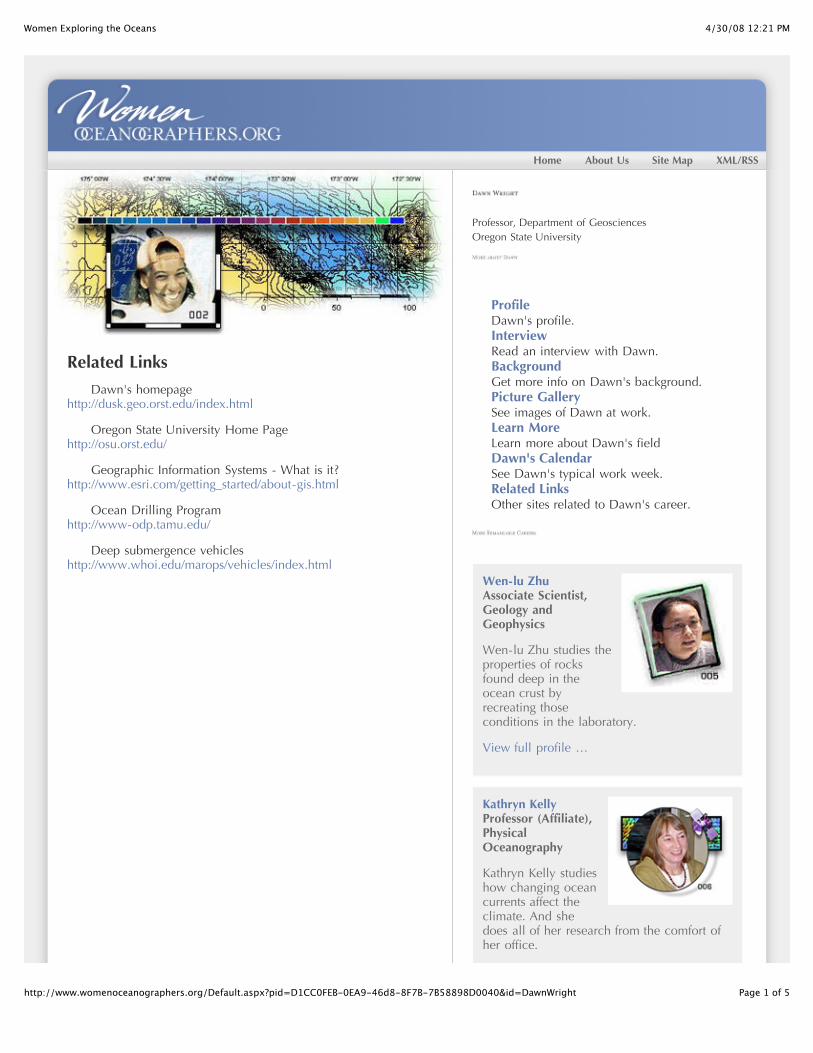
Related Links
Dawn's homepagehttp://dusk.geo.orst.edu/index.html
Oregon State University Home Pagehttp://osu.orst.edu/
Geographic Information Systems - What is it? http://www.esri.com/getting_started/about-gis.html
Ocean Drilling Programhttp://www-odp.tamu.edu/
Deep submergence vehicleshttp://www.whoi.edu/marops/vehicles/index.html
Professor, Department of GeosciencesOregon State University
ProfileDawn's profile.InterviewRead an interview with Dawn.BackgroundGet more info on Dawn's background.Picture GallerySee images of Dawn at work.Learn MoreLearn more about Dawn's fieldDawn's CalendarSee Dawn's typical work week.Related LinksOther sites related to Dawn's career.
Wen-lu ZhuAssociate Scientist,Geology andGeophysics
Wen-lu Zhu studies theproperties of rocksfound deep in theocean crust byrecreating thoseconditions in the laboratory.
View full profile …
Kathryn KellyProfessor (Affiliate),PhysicalOceanography
Kathryn Kelly studieshow changing oceancurrents affect theclimate. And shedoes all of her research from the comfort ofher office.