Embed Size (px)
Citation preview
Journal of Asian Earth Sciences 76 (2013) 85–94
Contents lists available at ScienceDirect
Journal of Asian Earth Sciences
journal homepage: www.elsevier .com/locate / jseaes
Holocene lake stages and thermokarst dynamics in a discontinuouspermafrost affected region, north-eastern Tibetan Plateau
1367-9120/$ - see front matter � 2013 Elsevier Ltd. All rights reserved.http://dx.doi.org/10.1016/j.jseaes.2013.08.006
⇑ Corresponding author. Address: Universität Potsdam, Karl-Liebknecht-Str. 24-25, 14476 Potsdam-Golm, Germany.
E-mail address: [email protected] (S. Opitz).
Stephan Opitz a,c,⇑, Arne Ramisch a, Steffen Mischke b,c, Bernhard Diekmann a
a Alfred Wegener Institute for Polar and Marine Research, Research Unit Potsdam, Telegrafenberg A43, 14473 Potsdam, Germanyb Institute of Geological Sciences, Freie Universität Berlin, Malteserstraße 74-100, 12249 Berlin, Germanyc Institute of Earth and Environmental Science of University Potsdam, Karl-Liebknecht-Str. 24-25, 14476 Potsdam-Golm, Germany
a r t i c l e i n f o
Article history:Received 19 February 2013Received in revised form 16 July 2013Accepted 5 August 2013Available online 17 August 2013
Keywords:Palaeoenvironmental reconstructionPalaeolimnologyLake levelXRD
a b s t r a c t
Sediments of a thermokarst system on the north-eastern Tibetan Plateau were studied to infer changes inthe lacustrine depositional environment related to climatic changes since the early Holocene. The ther-mokarst pond with a length of 360 m is situated in a 14.5 � 6 km tectonically unaffected intermontanebasin, which is underlain by discontinuous permafrost.
A lake sediment core and bankside lacustrine onshore deposits were analysed. Additionally, fossil lakesediments were investigated, which document a former lake-level high stand. The sediments are mainlycomposed of marls with variable amounts of silt carbonate micrite, and organic matter.
On the basis of sedimentological (grain size data), geochemical (XRF), mineralogical (XRD) and micro-paleontological data (ostracods and chironomide assemblages) a reconstruction of a paleolake environ-ment was achieved.
Lacustrine sediments with endogenic carbonate precipitation suggest a lacustrine environment since atleast 19.0 cal ka BP. However, because of relocation and reworking processes in the lake, the sedimentsdid not provide distinct information about the ultimate formation of the lake. The high amount of endo-genic carbonate suggests prolonged still-water conditions at about 9.3 cal ka BP. Ostracod shells and chi-ronomid head capsules in fossil lake sediments indicate at least one former lake-level high stand, whichwere developed between the early and middle Holocene. From the late Holocene the area was possiblycharacterized by a lake-level decline, documented by a hiatus between lacustrine sediments and areworked loess or loess-like horizon. After the lake-level decline and the following warming period,the area was affected by thermally-induced subsidence and a re-flooding of the basin because of thawingpermafrost.
� 2013 Elsevier Ltd. All rights reserved.
1. Introduction
The Qinghai–Tibet Plateau (QT) is situated in one of Earth’s ex-treme continental climate settings and is influenced by numerousclimatic regimes such as the East Asian monsoon, the Indian mon-soon, the northern winter monsoon and the westerly wind system.
Climate models predict that towards the middle of the 21stcentury the mean air temperature over the QTP will rise up to2.2–2.6 �C , which leads to a earlier onset of the South Asian mon-soon (Qian et al., 2011). This climate change will influence thelandscape dynamics and the hydro-climatic system on the QTP,which are known to respond sensitively to changes in temperatureand moisture availability (Beniston and Fox, 1996; Immerzeelet al., 2010). Socio-economical and ecological consequences are
expected (IPCC report 2007, Christensen et al., 2007), because theQTP is source area of the largest rivers in central Asia and thereforea very sensitive region for the water supply of billions of people(Huang et al., 2008). In this context it is essential to understandthe hydro-climatic system of the past for future climatepredictions.
For hydrologic reconstructions, lacustrine shoreline deposits inthe surrounding of lakes on the QTP and terrace sequences indicatepast lake-level fluctuations and provide valuable informationsabout moisture changes (Fan et al., 2011). Hydrological changeson the QTP are controlled by climate and environmental conditions(e.g. monsoon system; snow and glacier melt; evaporation; precip-itation; wind; and air temperature). However, a further less stud-ied factor is the effect of permafrost on hydrological processes asresult of changes in the thermal regime (Zhang et al., 2003).
Several investigations on ancient lake-level high- andlow-stands in the surrounding of the largest lakes have provideddetailed insights into the hydrological history of the QTP (e.g.
86 S. Opitz et al. / Journal of Asian Earth Sciences 76 (2013) 85–94
Madsen et al., 2008; Daut et al., 2010). However, to resolve theHolocene lake-level history quantitatively and in more detail onthe north-eastern QTP, ancient shore lines and littoral terracesaround small lakes (<1 km) situated in intramontane basins, whichare underlying by permafrost needs to be investigated. Thermok-arst (thaw-) pits or ponds represent highly dynamic features ofpermafrost landscapes on the north-eastern QTP and are knownto respond sensitively to climate change (Niu et al., 2011). Theyare typical landscape features of the north-eastern QTP, which de-velop as result of thawing ice-rich permafrost and/or meltingground ice (Brown and Grave, 1979; Lin et al., 2011). The occur-rence of the thermokarst ponds may indicate unstable or warmingpermafrost conditions (Smith et al., 2005; Niu et al., 2011). Thedeepening of such water bodies is related to ground ice contentand the length of time since permafrost thawing began (Burnand Smith, 1990; Lin et al., 2010). However, most thermokarstponds may drain after the permafrost has finally thawed (Sellmannet al., 1975; Kozlenko and Jeffries, 2000; Mackay and Burn, 2002;Lin et al., 2010). Recent studies on the source areas of the YangtzeRiver, the Yellow River, and the Lantsang River on the QTP indicatethat thermokarst lakes tend to shrink or disappear, which has im-pacted the hydrology and ecological environment (Niu et al., 2011).However, in the continuous permafrost region along the Qinghai–Tibet railway, the number of the thermokarst lakes and ponds hasbeen increasing, due to the warming of the local climate (Wang,1993).
During fieldwork in 2009, thermokarst pond and elevated fossillake sediments in a permafrost affected intermontane basin at thesource area of Yellow River (Huang He) on the north-eastern QTPwere investigated. The main objective of our study is to explainthe former lake-level high stand in the tectonically unaffected ba-sin and to answer the following question: Did a large lake exist inthe study area during the Holocene on the north-eastern QTP be-cause of changing climate and environmental conditions? For theidentification of the lacustrine depositional environment and forthe paleoenvironmental reconstruction we used sedimentologicaland micropaleontological analysis.
2. Regional setting
2.1. Thermokarst pond and its regional setting
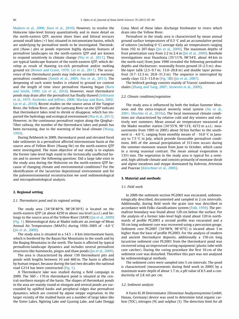
The study area (34�5804000N, 98�2803000E) is located on thenorth-eastern QTP (at about 4250 m above sea level (a.s.l.) and be-longs to the source area of the Yellow River (SAYR) (Jin et al., 2009)(Fig. 1). Meteorological data at Madoi indicate an average of MeanAnnual Air Temperatures (MAATs) during 1956–2005 of �4.0 �C(Jin et al., 2009).
The study area is situated in a 14.5 � 6 km intermontane basin,which is bordered by the Bayan Har Mountains in the south and bythe Buqing Mountains in the north. The basin is affected by typicalpermafrost-landscape dynamics and includes several permafroststructures like hummocks, pingos and thaw ponds (Jin et al., 2009).
The area is characterized by about 130 thermokarst pits andponds with lengths between 10 and 460 m. The basin is affectedby human impact, because during the last two decades the nationalroad G214 has been constructed (Fig. 1).
A Thermokarst lake was studied during a field campaign in2009. The 360 � 170 m thermokarst pond is situated at the cen-tral-northern margin of the basin. The shapes of thermokast pondsin the area are mainly round or elongate and several ponds are sur-rounded by uplifted banks and peripheral ridges due permafrostdynamics, which are covered by alpine steppe vegetation. In thelarger vicinity of the studied basin are a number of large lakes likethe Sister Lakes, Ngöring Lake and Gyaring Lake, and Lake Donggi
Cona. Most of these lakes discharge freshwater to rivers whichdrain into the Yellow River.
Permafrost in the study area is characterized by mean annualground surface temperatures of 0.3 �C and an accumulative periodof subzero (including 0 �C) average daily air temperatures rangingfrom 192 to 207 days (Jin et al., 2009). The maximum depths offrost penetration vary from 2.2 to 2.4 m (Jin et al., 2009). Boreholeinvestigations near Huashixia (35�110N, 98�540E, about 44 km tothe north-east) from June 1990 revealed the following permafrostdepths and thicknesses: seasonally frozen ground (0–2.5 m); dou-ble-layer talik (2.5–9.7 m; 13.0–20.8 m) and double layer perma-frost (9.7–12.3 m; 20.8–31.3 m). The sequence is interrupted bysandy clays 12.3–13.0 m (Fig. 1D) (Jin et al., 2007).
The bedrock geology consists mainly of Triassic sandstones andshales (Zhang and Yang, 2007; Stroeven et al., 2009).
2.2. Climate conditions/vegetation
The study area is influenced by both the Indian Summer Mon-soon and the extra-tropical westerly wind system (An et al.,2001; Mischke et al., 2010a). The local monsoonal climate condi-tions are characterized by relative cold and dry winters and rela-tively wet summers. Mean annual air temperature measured atthe Madoi weather station (34�550N, 98�130E, 4272 m a.s.l.; mea-surements from 1995 to 2005) about 50 km further to the south-west is �4.0 �C, ranging from monthly means of �16.0 �C in Janu-ary to 7.5 �C in July, which provide favourable permafrost condi-tions. 84% of the annual precipitation of 313 mm occurs duringthe summer-monsoon season from June to October, which causein a strong seasonal contrast. The mean annual evaporation is1351 mm. The vegetation in the study area is typical for a semi-arid, high-altitude climate and consists primarily of montane shruband alpine meadows and steppe dominated by Kobresia, Artemisiaand Poaceae (Kürschner et al., 2005).
3. Material and methods
3.1. Field work
In 2009 the sediment section PG2003 was excavated, sedimen-tologically described, documented and sampled in 2 cm intervalls.Additionally, during field work the grain size was described inaccordance with Folks classifications system (Folk, 1959). The per-mafrost boundary was found about 120 cm below the surface. Forthe analysis of a former lake-level high stand about 120 m north-wards of profile PG2003 a second profile was excavated and a50 cm long sediment core was recovered using a percussion gouge.Sediment core PG2007 (34�980N, 98�470E) is located about 5 mhigher than the base of profile PG2003. For the analysis of modernand ancient thermokarst deposits, additionally a 150 cm longlacustrine sediment core PG2001 from the thermokarst pond wasrecovered using an improvised coring equipment (plastic tube withcore catcher). During the coring procedure the first 10 cm of thesediment core was disturbed. Therefore this part was not analysedby sedimentological methods.
The sediment cores were sampled into 5 cm intervals. The pondis characterized (measurements during field work in 2009) by amaximum water depth of about 1.7 m, a pH value of 8.5 and a con-ductivity of 2.8 mS per cm.
3.2. Sediment analysis
A Vario EL III Determinator (Elementar Analysensysteme GmbH,Hanau, Germany) device was used to determine total organic car-bon (TOC), nitrogen (N) and sulphur (S). The detection limit for all
Fig. 1. Study area. A: Satellite Image of study region, situated on the north-eastern Tibetan Plateau. Black line illustrates catchment area of paleolake-basin. Yellow dotillustrates bore hole near to Huashixia (Jin et al., 2007). B: Aerial view of study area and the surveyed thermokarst lake including sampling positions. (34�977950N,98�476190E). Image source of landscape: Google Earth, October 26, 2003. C: Satellite image section from thermokarst basin and landscape profile including photograph fromstudy site (B): view from North to South. D: Lithology of recovered sediment core near to Huashixia. (For interpretation of the references to colour in this figure legend, thereader is referred to the web version of this article.)
S. Opitz et al. / Journal of Asian Earth Sciences 76 (2013) 85–94 87
elements was between 0.02% and 0.05%. A Coulter LS 200 (Beck-mann Coulter GmbH) device was used for grain-size analyses ofthe <1 mm fraction. A detailed description of the method is givenin Last, 2002, and references therein.
The mineralogical identification was performed by X-ray dif-fraction analysis (XRD) of powdered bulk material with PhilipsPW 1830, using a copper ka tube from 2 to 52�2h with steps of0.01�2h at AWI Bremerhaven. Mineral components were quantita-tively derived from the diffraction intensity (measured in countsper second, cps) using MacDiff 4.7 software. Major elements in sed-iment core PG2001 were measured at 5 mm intervals using anAVAATECH non-destructive X-ray Fluorescence (XRF) Core Scan-ner. The semi-quantitative XRF analyses were conducted using acurrent of 700 to 1000 mA with 10 kV, and 30 kV (Pompilio et al.,2007).
3.3. Ostracode analysis
Sediment subsamples from the profiles PG2003 and PG2007were dried at 50 �C and treated with a 3% solution of H2O2 beforesieving with a 100 lm mesh for microfossil analysis. All ostracodshells and chironomid head capsules were picked from the sieveresidues under a low-power binocular microscope. Ostracod iden-tification followed Meisch (2000), Mischke et al. (2010a) and a ref-erence collection at the Freie Universität Berlin.
3.4. Age determination
For radiocarbon dating we used bulk material, analysed by AMSPoznan Laboratory for radiocarbon dating. Calibrated 14C ages werecalculated using Oxcal 4.1 and the IntCal 09 calibration curve(Bronk Ramsey, 2009; Reimer et al., 2009). The 14C ages and addi-tional information are given in Table 1 and Chapter 5.2.
3.5. Remote sensing analysis
For the determination of the basin morphology and the lake-le-vel reconstruction, remote sensing data from various sources wereused: the Shuttle Radar Topography Mission (SRTM) (USGS, 2004)and the Advanced Spaceborne Thermal Emission and ReflectionRadiometer (ASTER L1B) digital terrain model, with a horizontalresolution of 90 m and 30 m, respectively. The data set was ana-lysed using ArcGIS 9.1 software, which was also used to create abasin relief model. Thaw lakes, inflows and outflows of the studysite were mapped in Landsat 7 ETM + satellite-images. Field obser-vations and verifications were conducted during the field cam-paign in 2009.
4. Results
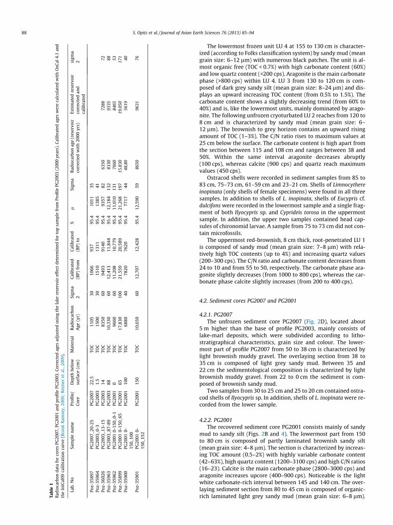
In the following we present results from sedimentological, min-eralogical and geochemical analyses for profile PG2003 and thesediment cores PG2007 and PG2001 (Figs. 2B, 3D and 4D).
4.1. Sediment profile PG2003
The profile PG2003 is situated at the south-eastern shore line ofthe thermokarst pond and mainly consists of fine grained lake-marl deposits, excluding the topmost part. The sand content withinthe sediments ranges from 5% to 30%, silt content from 60% to 80%and clay from 3% to 33% (Fig. 3). Quartz intensities in X-ray diffrac-tograms vary between 50 and 400 cps. The carbonate contentranges from 20% to 62% and shows a good correlation to aragoniteintensities, which range from 100 to 1200 cps. Calcite content is in-versely correlated to the aragonite content and ranges from 200 to1200 cps. TOC content ranges between 0.5% and 4% in profilePG2003 and the C/N ratio varies between 8 and 24.
Tabl
e1
Radi
ocar
bon
data
for
core
sPG
2007
,PG
2001
and
profi
lePG
2003
.Cor
rect
edag
esad
just
edus
ing
the
lake
rese
rvoi
ref
fect
dete
rmin
edfo
rto
psa
mpl
efr
omPr
ofile
PG20
03(2
000
year
s).C
alib
rate
dag
esw
ere
calc
ulat
edw
ith
OxC
al4.
1an
dth
eIn
tCal
09ca
libra
tion
curv
e(B
ronk
Ram
sey,
2009
;Re
imer
etal
.,20
09).
Lab.
No
Sam
ple
nam
ePr
ofile
/C
ore
Dep
thbe
low
surf
ace
(cm
)M
ater
ial
Rad
ioca
rbon
Age
(yr)
Sigm
a2
Cal
ibra
ted
(BP)
from
Cal
ibra
ted
(BP)
to%
lSi
gma
Rad
ioca
rbon
age
(res
ervo
irco
rrec
ted
wit
h20
00yr
s)Es
tim
ated
rese
rvoi
rco
rrec
ted
and
cali
brat
ed
sigm
a2
Poz-
3589
7PG
2007
_20-
25PG
2007
22.5
TOC
1105
3010
6693
795
.410
1135
Poz-
3596
4PG
2003
_0-3
PG20
031.
5TO
C15
0030
1510
1311
95.4
1385
41Po
z-36
026
PG20
03_1
3-15
PG20
0314
TOC
8350
6094
9391
4095
.493
5782
6350
7288
72Po
z-35
963
PG20
03_8
7-89
PG20
0388
TOC
10,3
3060
12,4
1311
,844
95.4
12,1
8413
283
3093
3588
Poz-
3596
2PG
2001
0-15
0_0-
1PG
2001
0TO
C96
6060
11,2
0810
,779
95.4
11,0
1013
176
6084
6553
Poz-
3589
9PG
2001
0-15
0_65
PG20
0165
TOC
17,8
3010
021
,559
20,5
8995
.421
,268
197
15,8
3019
,050
171
Poz-
3590
0PG
2001
0-15
0_10
0PG
2001
100
TOC
6880
4078
2076
2095
.477
1744
48,8
056
1940
Poz-
3590
1PG
2001
0-15
0_15
2PG
2001
150
TOC
10,6
5060
12,7
0712
,428
95.4
12,5
9059
8650
9631
76
88 S. Opitz et al. / Journal of Asian Earth Sciences 76 (2013) 85–94
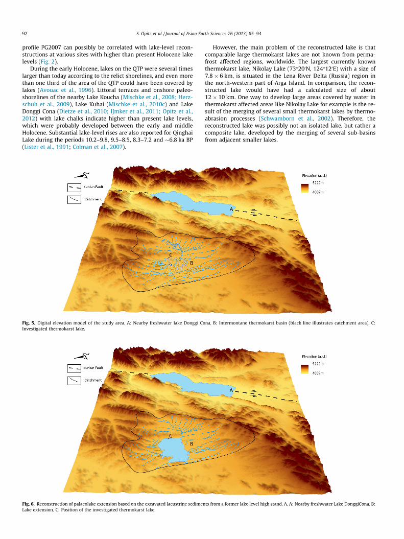
The lowermost frozen unit LU 4 at 155 to 130 cm is character-ized (according to Folks classification system) by sandy mud (meangrain size: 6–12 lm) with numerous black patches. The unit is al-most organic free (TOC < 0.7%) with high carbonate content (60%)and low quartz content (<200 cps). Aragonite is the main carbonatephase (>800 cps) within LU 4. LU 3 from 130 to 120 cm is com-posed of dark grey sandy silt (mean grain size: 8–24 lm) and dis-plays an upward increasing TOC content (from 0.5% to 1.5%). Thecarbonate content shows a slightly decreasing trend (from 60% to40%) and is, like the lowermost units, mainly dominated by arago-nite. The following unfrozen cryoturbated LU 2 reaches from 120 to8 cm and is characterized by sandy mud (mean grain size: 6–12 lm). The brownish to grey horizon contains an upward risingamount of TOC (1–3%). The C/N ratio rises to maximum values at25 cm below the surface. The carbonate content is high apart fromthe section between 115 and 108 cm and ranges between 38 and50%. Within the same interval aragonite decreases abruptly(100 cps), whereas calcite (900 cps) and quartz reach maximumvalues (450 cps).
Ostracod shells were recorded in sediment samples from 85 to83 cm, 75–73 cm, 61–59 cm and 23–21 cm. Shells of Limnocythereinopinata (only shells of female specimens) were found in all threesamples. In addition to shells of L. inopinata, shells of Eucypris cf.dulcifons were recorded in the lowermost sample and a single frag-ment of both Ilyocypris sp. and Cyprideis torosa in the uppermostsample. In addition, the upper two samples contained head cap-sules of chironomid larvae. A sample from 75 to 73 cm did not con-tain microfossils.
The uppermost red-brownish, 8 cm thick, root-penetrated LU 1is composed of sandy mud (mean grain size: 7–8 lm) with rela-tively high TOC contents (up to 4%) and increasing quartz values(200–300 cps). The C/N ratio and carbonate content decreases from24 to 10 and from 55 to 50, respectively. The carbonate phase ara-gonite slightly decreases (from 1000 to 800 cps), whereas the car-bonate phase calcite slightly increases (from 200 to 400 cps).
4.2. Sediment cores PG2007 and PG2001
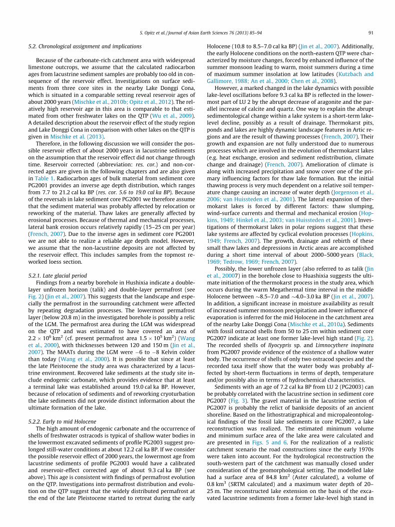
4.2.1. PG2007The unfrozen sediment core PG2007 (Fig. 2D), located about
5 m higher than the base of profile PG2003, mainly consists oflake-marl deposits, which were subdivided according to litho-stratigraphical characteristics, grain size and colour. The lower-most part of profile PG2007 from 50 to 38 cm is characterized bylight brownish muddy gravel. The overlaying section from 38 to35 cm is composed of light grey sandy mud. Between 35 and22 cm the sedimentological composition is characterized by lightbrownish muddy gravel. From 22 to 0 cm the sediment is com-posed of brownish sandy mud.
Two samples from 30 to 25 cm and 25 to 20 cm contained ostra-cod shells of Ilyocypris sp. In addition, shells of L. inopinata were re-corded from the lower sample.
4.2.2. PG2001The recovered sediment core PG2001 consists mainly of sandy
mud to sandy silt (Figs. 2B and 4). The lowermost part from 150to 80 cm is composed of partly laminated brownish sandy silt(mean grain size: 4–8 lm). The section is characterized by increas-ing TOC amount (0.5–2%) with highly variable carbonate content(42–63%), high quartz content (1200–3100 cps) and high C/N ratios(16–23). Calcite is the main carbonate phase (2800–3000 cps) andaragonite increases upcore (400–900 cps). Noticeable is the lightwhite carbonate-rich interval between 145 and 140 cm. The over-laying sediment section from 80 to 45 cm is composed of organic-rich laminated light grey sandy mud (mean grain size: 6–8 lm).
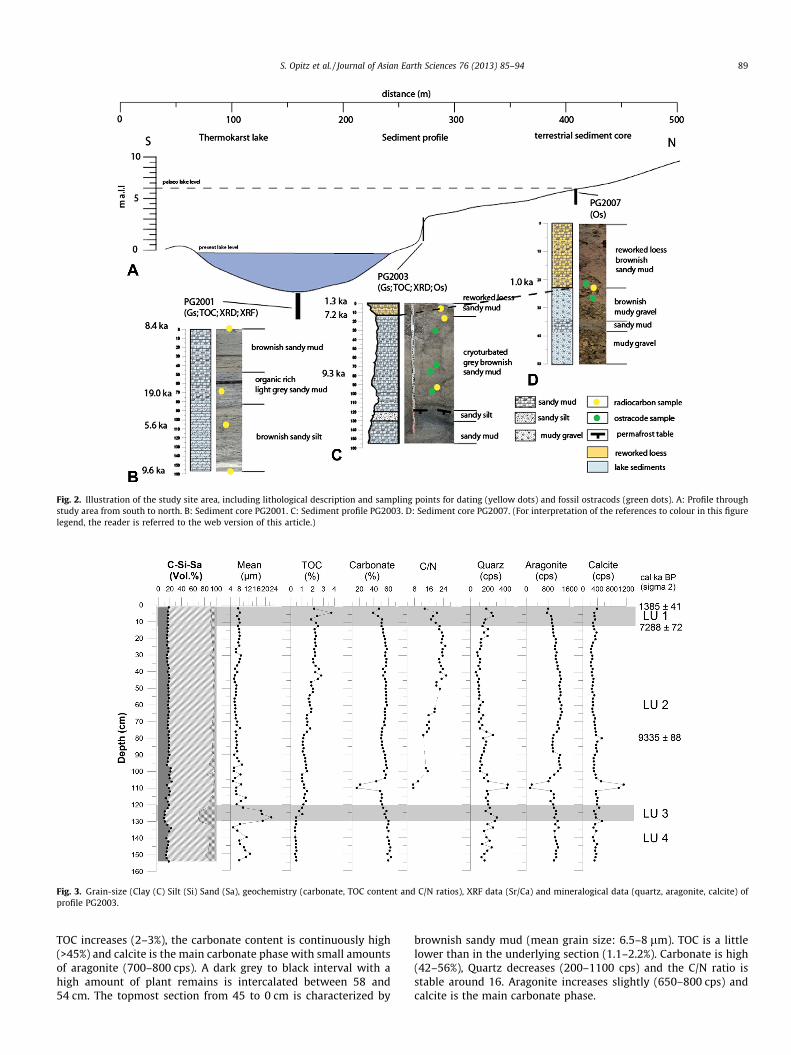
Fig. 2. Illustration of the study site area, including lithological description and sampling points for dating (yellow dots) and fossil ostracods (green dots). A: Profile throughstudy area from south to north. B: Sediment core PG2001. C: Sediment profile PG2003. D: Sediment core PG2007. (For interpretation of the references to colour in this figurelegend, the reader is referred to the web version of this article.)
Fig. 3. Grain-size (Clay (C) Silt (Si) Sand (Sa), geochemistry (carbonate, TOC content and C/N ratios), XRF data (Sr/Ca) and mineralogical data (quartz, aragonite, calcite) ofprofile PG2003.
S. Opitz et al. / Journal of Asian Earth Sciences 76 (2013) 85–94 89
TOC increases (2–3%), the carbonate content is continuously high(>45%) and calcite is the main carbonate phase with small amountsof aragonite (700–800 cps). A dark grey to black interval with ahigh amount of plant remains is intercalated between 58 and54 cm. The topmost section from 45 to 0 cm is characterized by
brownish sandy mud (mean grain size: 6.5–8 lm). TOC is a littlelower than in the underlying section (1.1–2.2%). Carbonate is high(42–56%), Quartz decreases (200–1100 cps) and the C/N ratio isstable around 16. Aragonite increases slightly (650–800 cps) andcalcite is the main carbonate phase.
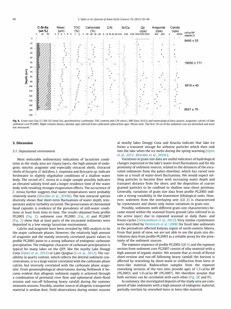
Fig. 4. Grain-size Clay (C) Silt (Si) Sand (Sa), geochemistry (carbonate, TOC content and C/N ratios), XRF Data (Sr/Ca) and mineralogical data (quartz, aragonite, calcite) of lakesediment core PG2001. Right column shows calendar ages inferred from calibrated radiocarbon ages. Please note: The first 10 cm of the sediment core are disturbed and werenot measured.
90 S. Opitz et al. / Journal of Asian Earth Sciences 76 (2013) 85–94
5. Discussion
5.1. Depositional environment
Most noticeable sedimentary indications of lacustrine condi-tions in the study area are clayey layers, the high amount of endo-genic micritic aragonite and especially ostracod shells. Ostracodshells of Eucypris cf. dulcifons, L. inopinata and Ilyocypris sp. indicatefreshwater to slightly oligohaline conditions of a shallow waterbody. The record of C. torosa in a single sample possibly indicatesan elevated salinity level and a longer residence time of the waterbody with resulting stronger evaporation effects. The occurrence ofC. torosa further suggests that water temperatures were probablyrelatively warm (Mischke et al., 2010b). The low ostracod speciesdiversity shows that short-term fluctuations of water depth, tem-perature and/or turbidity occurred. The preservation of chironomidhead capsules is evidence of the prevalence of still-water condi-tions at least from time to time. The results obtained from profilePG2003 (Fig. 3), sediment core PG2001 (Fig. 4) and PG2007(Fig. 2) show that at least parts of the excavated sediments weredeposited in a low energy lacustrine environment.
Calcite and aragonite have been revealed by XRD analysis to bethe major carbonate phases. However, the relatively high amountof aragonite and the mainly inversely correlated quartz values inprofile PG2003 point to a strong influence of endogenic carbonateprecipitation. The endogenic character of carbonate precipitation istypical for many lakes on the QTP, like the nearby Lake DonggiCona (Opitz et al., 2012) or Lake Qinghai (Li et al., 2012). The var-iability in quartz content, which reflects the detrital sediment con-centrations, is to a large extent correlated with the carbonate phasecalcite, but inversely correlated with the carbonate phase arago-nite. From geomorphological observations during fieldwork it be-came evident that allogenic sediment supply is achieved througha combination of perennial river flow and ephemeral sheet-flooderosion and run-off following heavy rainfall during the summermonsoon seasons. Possibly, another source of allogenic transportedmaterial is aeolian dust. Field observations during winter seasons
at nearby lakes Donggi Cona and Koucha indicate that lake iceforms a transient storage for airborne particles which then sinkinto the lake when the ice melts during the spring warming (Opitzet al., 2012; Mischke et al., 2010c).
Variations in grain size data are useful indicators of hydrologicalchanges expressed in the lake’s water-level fluctuations and for theproximity of sediment sources, related to the distances of the exca-vated sediments from the paleo-shoreline, which has varied overtime as a result of water-level fluctuations. We would expect set-tling particles to become finer with increasing water depth andtransport distance from the shore, and the deposition of coarsergrained particles to be confined to shallow near-shore positions.Generally, variations of grain size data from profile PG2003 indi-cate a strong variability in the lowermost lithological units. How-ever, sediment from the overlaying unit (LU 2) is characterizedby cryotextures and shows only minor variations in grain size.
Possibly, sediments with different grain-size characteristics be-came mixed within the seasonal frozen ground (also referred to asthe active layer) due to repeated seasonal or daily thaw- andfreeze-cycles (Schwamborn et al., 2012). Very similar cryotextureswere described by Wetterich et al. (2008) for fossil lake sedimentsin the permafrost-affected Kolyma region of north-eastern Siberia.From that point of view, we are not able to use the grain size dis-tribution data from profile PG2003 as a reliable proxy for the prox-imity of the sediment sources.
The topmost sequence of profile PG2003 (LU 1) and the topmostsection from sediment core PG2007 consist of silty material with ahigh amount of organic matter. We assume that as result of fluvialsheet-erosion and run-off following heavy rainfall the horizon isaffected by reworking by sheet-wash or solifluction from loess orloess-like material. Radiocarbon samples from the topmostreworking sections of the two sites provide ages of 1.3 cal ka BP(PG2003) and 1.0 cal ka BP (PG2007). We therefore assume thatboth sections can be correlated with each other (Fig. 2C and D).
In summary, the investigated deposits of the study area are com-posed of lake sediments with a high amount of endogenic material,partially overlain by reworked loess or loess-like material.
S. Opitz et al. / Journal of Asian Earth Sciences 76 (2013) 85–94 91
5.2. Chronological assignment and implications
Because of the carbonate-rich catchment area with widespreadlimestone outcrops, we assume that the calculated radiocarbonages from lacustrine sediment samples are probably too old in con-sequence of the reservoir effect. Investigations on surface sedi-ments from three core sites in the nearby Lake Donggi Cona,which is situated in a comparable setting reveal reservoir ages ofabout 2000 years (Mischke et al., 2010b; Opitz et al., 2012). The rel-atively high reservoir age in this area is comparable to that esti-mated from other freshwater lakes on the QTP (Wu et al., 2009).A detailed description about the reservoir effect of the study regionand Lake Donggi Cona in comparison with other lakes on the QTP isgiven in Mischke et al. (2013).
Therefore, in the following discussion we will consider the pos-sible reservoir effect of about 2000 years in lacustrine sedimentson the assumption that the reservoir effect did not change throughtime. Reservoir corrected (abbreviation: res. cor.) and non-cor-rected ages are given in the following chapters and are also givenin Table 1. Radiocarbon ages of bulk material from sediment corePG2001 provides an inverse age depth distribution, which rangesfrom 7.7 to 21.2 cal ka BP (res. cor. 5.6 to 19.0 cal ka BP). Becauseof the reversals in lake sediment core PG2001 we therefore assumethat the sediment material was probably affected by relocation orreworking of the material. Thaw lakes are generally affected byerosional processes. Because of thermal and mechanical processes,lateral bank erosion occurs relatively rapidly (15–25 cm per year)(French, 2007). Due to the inverse ages in sediment core PG2001we are not able to realize a reliable age depth model. However,we assume that the non-lacustrine deposits are not affected bythe reservoir effect. This includes samples from the topmost re-worked loess section.
5.2.1. Late glacial periodFindings from a nearby borehole in Hushixia indicate a double-
layer unfrozen horizon (talik) and double-layer permafrost (seeFig. 2) (Jin et al., 2007). This suggests that the landscape and espe-cially the permafrost in the surrounding catchment were affectedby repeating degradation processes. The lowermost permafrostlayer (below 20.8 m) in the investigated borehole is possibly a relicof the LGM. The permafrost area during the LGM was widespreadon the QTP and was estimated to have covered an area of2.2 � 106 km2 (cf. present permafrost area 1.5 � 105 km2) (Wanget al., 2000), with thicknesses between 120 and 150 m (Jin et al.,2007). The MAATs during the LGM were �6 to �8 Kelvin colderthan today (Wang et al., 2000). It is possible that since at leastthe late Pleistocene the study area was characterized by a lacus-trine environment. Recovered lake sediments at the study site in-clude endogenic carbonate, which provides evidence that at leasta terminal lake was established around 19.0 cal ka BP. However,because of relocation of sediments and of reworking cryoturbationthe lake sediments did not provide distinct information about theultimate formation of the lake.
5.2.2. Early to mid HoloceneThe high amount of endogenic carbonate and the occurrence of
shells of freshwater ostracods is typical of shallow water bodies inthe lowermost excavated sediments of profile PG2003 suggest pro-longed still-water conditions at about 12.2 cal ka BP. If we considerthe possible reservoir effect of 2000 years, the lowermost age fromlacustrine sediments of profile PG2003 would have a calibratedand reservoir-effect corrected age of about 9.3 cal ka BP (seeabove). This age is consistent with findings of permafrost evolutionon the QTP. Investigations into permafrost distribution and evolu-tion on the QTP suggest that the widely distributed permafrost atthe end of the late Pleistocene started to retreat during the early
Holocene (10.8 to 8.5–7.0 cal ka BP) (Jin et al., 2007). Additionally,the early Holocene conditions on the north-eastern QTP were char-acterized by moisture changes, forced by enhanced influence of thesummer monsoon leading to warm, moist summers during a timeof maximum summer insolation at low latitudes (Kutzbach andGallimore, 1988; An et al., 2000; Chen et al., 2008).
However, a marked changed in the lake dynamics with possiblelake-level oscillations before 9.3 cal ka BP is reflected in the lower-most part of LU 2 by the abrupt decrease of aragonite and the par-allel increase of calcite and quartz. One way to explain the abruptsedimentological change within a lake system is a short-term lake-level decline, possibly as a result of drainage. Thermokarst pits,ponds and lakes are highly dynamic landscape features in Artic re-gions and are the result of thawing processes (French, 2007). Theirgrowth and expansion are not fully understood due to numerousprocesses which are involved in the evolution of thermokarst lakes(e.g. heat exchange, erosion and sediment redistribution, climatechange and drainage) (French, 2007). Amelioration of climate isalong with increased precipitation and snow cover one of the pri-mary influencing factors for thaw lake formation. But the initialthawing process is very much dependent on a relative soil temper-ature change causing an increase of water depth (Jorgenson et al.,2006; van Huissteden et al., 2001). The lateral expansion of ther-mokarst lakes is forced by different factors: thaw slumping,wind-surface currents and thermal and mechanical erosion (Hop-kins, 1949; Hinkel et al., 2003; van Huissteden et al., 2001). Inves-tigations of thermokarst lakes in polar regions suggest that theselake systems are affected by cyclical evolution processes (Hopkins,1949; French, 2007). The growth, drainage and rebirth of thesesmall thaw lakes and depressions in Arctic areas are accomplishedduring a short time interval of about 2000–5000 years (Black,1969; Tedrow, 1969; French, 2007).
Possibly, the lower unfrozen layer (also referred to as talik (Jinet al., 20007) in the borehole close to Huashixia suggests the ulti-mate initiation of the thermokarst process in the study area, whichoccurs during the warm Megathermal time interval in the middleHolocene between �8.5–7.0 and �4.0–3.0 ka BP (Jin et al., 2007).In addition, a significant increase in moisture availability as resultof increased summer monsoon precipitation and lower influence ofevaporation is inferred for the mid Holocene in the catchment areaof the nearby Lake Donggi Cona (Mischke et al., 2010a). Sedimentswith fossil ostracod shells from 50 to 25 cm within sediment corePG2007 indicate at least one former lake-level high stand (Fig. 2).The recorded shells of Ilyocypris sp. and Limnocythere inopinatafrom PG2007 provide evidence of the existence of a shallow waterbody. The occurrence of shells of only two ostracod species and therecorded taxa itself show that the water body was probably af-fected by short-term fluctuations in terms of depth, temperatureand/or possibly also in terms of hydrochemical characteristics.
Sediments with an age of 7.2 cal ka BP from LU 2 (PG2003) canbe probably correlated with the lacustrine section in sediment corePG2007 (Fig. 3). The gravel material in the lacustrine section ofPG2007 is probably the relict of bankside deposits of an ancientshoreline. Based on the lithostratigraphical and micropaleontolog-ical findings of the fossil lake sediments in core PG2007, a lakereconstruction was realized. The estimated minimum volumeand minimum surface area of the lake area were calculated andare presented in Figs. 5 and 6. For the realization of a realisticcatchment scenario the road constructions since the early 1970swere taken into account. For the hydrological reconstruction thesouth-western part of the catchment was manually closed underconsideration of the geomorphological setting. The modelled lakehad a surface area of 84.8 km2 (Aster calculated), a volume of0.8 km3 (SRTM calculated) and a maximum water depth of 20–25 m. The reconstructed lake extension on the basis of the exca-vated lacustrine sediments from a former lake-level high stand in
92 S. Opitz et al. / Journal of Asian Earth Sciences 76 (2013) 85–94
profile PG2007 can possibly be correlated with lake-level recon-structions at various sites with higher than present Holocene lakelevels (Fig. 2).
During the early Holocene, lakes on the QTP were several timeslarger than today according to the relict shorelines, and even morethan one third of the area of the QTP could have been covered bylakes (Avouac et al., 1996). Littoral terraces and onshore paleo-shorelines of the nearby Lake Koucha (Mischke et al., 2008; Herz-schuh et al., 2009), Lake Kuhai (Mischke et al., 2010c) and LakeDonggi Cona (Dietze et al., 2010; IJmker et al., 2011; Opitz et al.,2012) with lake chalks indicate higher than present lake levels,which were probably developed between the early and middleHolocene. Substantial lake-level rises are also reported for QinghaiLake during the periods 10.2–9.8, 9.5–8.5, 8.3–7.2 and �6.8 ka BP(Lister et al., 1991; Colman et al., 2007).
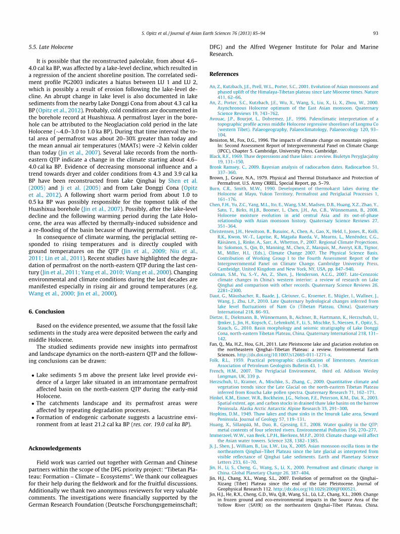
Fig. 5. Digital elevation model of the study area. A: Nearby freshwater lake Donggi CoInvestigated thermokarst lake.
Fig. 6. Reconstruction of palaeolake extension based on the excavated lacustrine sedimenLake extension. C: Position of the investigated thermokarst lake.
However, the main problem of the reconstructed lake is thatcomparable large thermokarst lakes are not known from perma-frost affected regions, worldwide. The largest currently knownthermokarst lake, Nikolay Lake (73�200N, 124�120E) with a size of7.8 � 6 km, is situated in the Lena River Delta (Russia) region inthe north-western part of Arga Island. In comparison, the recon-structed lake would have had a calculated size of about12 � 10 km. One way to develop large areas covered by water inthermokarst affected areas like Nikolay Lake for example is the re-sult of the merging of several small thermokarst lakes by thermo-abrasion processes (Schwamborn et al., 2002). Therefore, thereconstructed lake was possibly not an isolated lake, but rather acomposite lake, developed by the merging of several sub-basinsfrom adjacent smaller lakes.
na. B: Intermontane thermokarst basin (black line illustrates catchment area). C:
ts from a former lake level high stand. A. A: Nearby freshwater Lake DonggiCona. B:
S. Opitz et al. / Journal of Asian Earth Sciences 76 (2013) 85–94 93
5.5. Late Holocene
It is possible that the reconstructed paleolake, from about 4.6–4.0 cal ka BP, was affected by a lake-level decline, which resulted ina regression of the ancient shoreline position. The correlated sedi-ment profile PG2003 indicates a hiatus between LU 1 and LU 2,which is possibly a result of erosion following the lake-level de-cline. An abrupt change in lake level is also documented in lakesediments from the nearby Lake Donggi Cona from about 4.3 cal kaBP (Opitz et al., 2012). Probably, cold conditions are documented inthe borehole record at Huashixua. A permafrost layer in the bore-hole can be attributed to the Neoglaciation cold period in the lateHolocene (�4.0–3.0 to 1.0 ka BP). During that time interval the to-tal area of permafrost was about 20–30% greater than today andthe mean annual air temperatures (MAATs) were -2 Kelvin colderthan today (Jin et al., 2007). Several lake records from the north-eastern QTP indicate a change in the climate starting about 4.6–4.0 cal ka BP. Evidence of decreasing monsoonal influence and atrend towards dryer and colder conditions from 4.3 and 3.9 cal kaBP have been reconstructed from Lake Qinghai by Shen et al.(2005) and Ji et al. (2005) and from Lake Donggi Cona (Opitzet al., 2012). A following short warm period from about 1.0 to0.5 ka BP was possibly responsible for the topmost talik of theHuashixua borehole (Jin et al., 2007). Possibly, after the lake-leveldecline and the following warming period during the Late Holo-cene, the area was affected by thermally-induced subsidence anda re-flooding of the basin because of thawing permafrost.
In consequence of climate warming, the periglacial setting re-sponded to rising temperatures and is directly coupled withground temperatures on the QTP (Jin et al., 2009; Niu et al.,2011; Lin et al., 2011). Recent studies have highlighted the degra-dation of permafrost on the north-eastern QTP during the last cen-tury (Jin et al., 2011; Yang et al., 2010; Wang et al., 2000). Changingenvironmental and climate conditions during the last decades aremanifested especially in rising air and ground temperatures (e.g.Wang et al., 2000; Jin et al., 2000).
6. Conclusion
Based on the evidence presented, we assume that the fossil lakesediments in the study area were deposited between the early andmiddle Holocene.
The studied sediments provide new insights into permafrostand landscape dynamics on the north-eastern QTP and the follow-ing conclusions can be drawn:
� Lake sediments 5 m above the present lake level provide evi-dence of a larger lake situated in an intramontane permafrostaffected basin on the north-eastern QTP during the early-midHolocene.� The catchments landscape and its permafrost areas were
affected by repeating degradation processes.� Formation of endogenic carbonate suggests a lacustrine envi-
ronment from at least 21.2 cal ka BP (res. cor. 19.0 cal ka BP).
Acknowledgements
Field work was carried out together with German and Chinesepartners within the scope of the DFG priority project: ‘‘Tibetan Pla-teau: Formation – Climate – Ecosystems’’. We thank our colleaguesfor their help during the fieldwork and for the fruitful discussions.Additionally we thank two anonymous reviewers for very valuablecomments. The investigations were financially supported by theGerman Research Foundation (Deutsche Forschungsgemeinschaft;
DFG) and the Alfred Wegener Institute for Polar and MarineResearch.
References
An, Z., Kutzbach, J.E., Prell, W.L., Porter, S.C., 2001. Evolution of Asian monsoons andphased uplift of the Himalaya-Tibetan plateau since Late Miocene times. Nature411, 62–66.
An, Z., Porter, S.C., Kutzbach, J.E., Wu, X., Wang, S., Liu, X., Li, X., Zhou, W., 2000.Asynchronous Holocene optimum of the East Asian monsoon. QuaternaryScience Reviews 19, 743–762.
Avouac, J.P., Bourjot, L., Dobremez, J.F., 1996. Paleoclimatic interpretation of atopographic profile across middle Holocene regressive shorelines of Longmu Co(western Tibet). Palaeogeography, Palaeoclimatology, Palaeoecology 120, 93–104.
Beniston, M., Fox, D.G., 1996. The impacts of climate change on mountain regions.In: Second Assessment Report of Intergovernmental Panel on Climate Change(IPCC), Chapter 5. Cambridge, University Press, Cambridge.
Black, R.F., 1969. Thaw depressions and thaw lakes: a review. Biuletyn Peryglacjalny19, 131–150.
Bronk Ramsey, C., 2009. Bayesian analysis of radiocarbon dates. Radiocarbon 51,337–360.
Brown, J., Grave, N.A., 1979. Physical and Thermal Disturbance and Protection ofPermafrost. U.S. Army CRREL, Special Report, pp. 5–79.
Burn, C.R., Smith, M.W., 1990. Development of thermokarst lakes during theHolocene at Mayo, Yukon Territory. Permafrost and Periglacial Processes 1,161–176.
Chen, F.H., Yu, Z.C., Yang, M.L., Ito, E., Wang, S.M., Madsen, D.B., Huang, X.Z., Zhao, Y.,Sato, T., Birks, H.J.B., Boomer, I., Chen, J.H., An, C.B., Wünnemann, B., 2008.Holocene moisture evolution in arid central Asia and its out-of-phaserelationship with Asian monsoon history. Quaternary Science Reviews 27,351–364.
Christensen, J.H., Hewitson, B., Busuioc, A., Chen, A., Gao, X., Held, I., Jones, R., Kolli,R.K., Kwon, W.-T., Laprise, R., Magaña Rueda, V., Mearns, L., Menéndez, C.G.,Räisänen, J., Rinke, A., Sarr, A., Whetton, P., 2007. Regional Climate Projections.In: Solomon, S., Qin, D., Manning, M., Chen, Z., Marquis, M., Averyt, K.B., Tignor,M., Miller, H.L. (Eds.), Climate Change 2007. The Physical Science Basis.Contribution of Working Group I to the Fourth Assessment Report of theIntergovernmental Panel on Climate Change. Cambridge University Press,Cambridge, United Kingdom and New York, NY, USA, pp. 847–940.
Colman, S.M., Yu, S.-Y., An, Z., Shen, J., Henderson, A.C.G., 2007. Late-Cenozoicclimate changes in China’s western interior: a review of research on LakeQinghai and comparison with other records. Quaternary Science Reviews 26,2281–2300.
Daut, G., Mäusbacher, R., Baade, J., Gleixner, G., Kroemer, E., Mügler, I., Wallner, J.,Wang, J., Zhu, L.P., 2010. Late Quaternary hydrological changes inferred fromlake level fluctuations of Nam Co (Tibetan Plateau, China). QuaternaryInternational 218, 86–93.
Dietze, E., Diekmann, B., Wünnemann, B., Aichner, B., Hartmann, K., Herzschuh, U.,IJmker, J., Jin, H., Kopsch, C., Lehmkuhl, F., Li, S., Mischke, S., Niessen, F., Opitz, S.,Stauch, G., 2010. Basin morphology and seismic stratigraphy of Lake DonggiCona, north-eastern Tibetan Plateau, China. Quaternary International 218, 131–142.
Fan, Q., Ma, H.Z., Hou, G.H., 2011. Late Pleistocene lake and glaciation evolution onthe northeastern Qinghai–Tibetan Plateau: a review. Environmental EarthSciences. http://dx.doi.org/10.1007/s12665-011-1271-x.
Folk, R.L., 1959. Practical petrographic classification of limestones. AmericanAssociation of Petroleum Geologists Bulletin 43, 1–38.
French, H.M., 2007. The Periglacial Environment, third ed. Addison WesleyLongman, UK, 339 p.
Herzschuh, U., Kramer, A., Mischke, S., Zhang, C., 2009. Quantitative climate andvegetation trends since the Late Glacial on the north-eastern Tibetan Plateauinferred from Koucha Lake pollen spectra. Quaternary Research 71, 162–171.
Hinkel, K.M., Eisner, W.R., Bockheim, J.G., Nelson, F.E., Peterson, K.M., Dai, X., 2003.Spatial extent, age, and carbon stocks in drained thaw lake basins on the barrowPeninsula. Alaska Arctic Antarctic Alpine Research 35, 291–300.
Hopkins, D.M., 1949. Thaw lakes and thaw sinks in the Imuruk Lake area, SewardPeninsula. Journal of Geology 57, 119–131.
Huang, X., Sillanpää, M., Duo, B., Gjessing, E.T., 2008. Water quality in the QTP:metal contents of four selected rivers. Environmental Pollution 156, 270–277.
Immerzeel, W.W., van Beek, L.P.H., Bierkens, M.F.P., 2010. Climate change will affectthe Asian water towers. Science 328, 1382–1385.
Ji, J., Shen, J., William, B., Liu, L.W., Liu, X., 2005. Asian monsoon oscilla tions in thenortheastern Qinghai–Tibet Plateau since the late glacial as interpreted fromvisible reflectance of Qinghai Lake sediments. Earth and Planetary ScienceLetters 233, 61–70.
Jin, H., Li, S., Cheng, G., Wang, S., Li, X., 2000. Permafrost and climatic change inChina. Global Planetary Change 26, 387–404.
Jin, H.J., Chang, X.L., Wang, S.L., 2007. Evolution of permafrost on the Qinghai–Xizang (Tibet) Plateau since the end of the late Pleistocene. Journal ofGeophysical Research 112. http://dx.doi.org/10.1029/2006JF000521.
Jin, H.J., He, R.X., Cheng, G.D., Wu, Q.B., Wang, S.L., Lü, L.Z., Chang, X.L., 2009. Changein frozen ground and eco-environmental impacts in the Source Area of theYellow River (SAYR) on the northeastern Qinghai–Tibet Plateau. China.
94 S. Opitz et al. / Journal of Asian Earth Sciences 76 (2013) 85–94
Environmental Research Letters 4. http://dx.doi.org/10.1088/1748-9326/4/4/045206.
Jin, H.J., Luo, D.L., Wang, S.L., Lü, L.Z., Wu, J.C., 2011. Spatiotemporal variability ofpermafrost degradation on the Qinghai–Tibet Plateau. Sciences in Cold and AridRegions 3, 281–305.
IJmker, J.M., Stauch, G., Hartmann, K., Diekmann, B., Dietze, E., Opitz, S.,Wünnemann, B., Lehmkuhl, F., 2011. Environmental conditions in the DonggiCona lake catchment, NE Tibetan Plateau, based on factor analysis ofgeochemical data. Journal of Asian Earth Sciences 44, 176–188.
Jorgenson, M.T., Shur, Y.L., Pullman, E.R., 2006. Abrupt increase in permafrostdegradation in Arctic Alaska. Geophysical Research Letters 33, 2–5.
Kozlenko, N., Jeffries, M.O., 2000. Bathymetric mapping of the shallow water inthermokarst lakes on the North Slope of Alaska with spaceborne imaging radar.Arctic 53, 306–316.
Kutzbach, J.E., Gallimore, R.G., 1988. Sensitivity of a coupled atmosphere/mixed-layer ocean model to changes in orbital forcing at 9000 years BP. Journal ofGeophysical Research 93, 803–821.
Kürschner, H., Herzschuh, U., Wagner, D., 2005. Phytosociological studies in thenorth-eastern Qinghai–Xizang Plateau (NW China) – a first contribution to thesubalpine scrub and alpine meadow vegetation. Botanische Jahrbuecher derSystematik 126, 273–315.
Last, W.M., 2002. Textural analysis of lake sediments. In: Last, W.M., Smol, J.P. (Eds.),Tracking Environmental Change using Lake Sediments. Kluwer AcademicPublisher, Dordrecht, pp. 41–81.
Li, X., Liu, W., Xu, L., 2012. Carbon isotopes in surface-sediment carbonates ofmodern Lake Qinghai (Qinghai–Tibet Plateau): implications for lake evolutionin arid areas. Chemical Geology 300–301, 88–96.
Lin, Z.J., Niu, F.J., Xu, Z.Y., 2010. Thermal regime of a thermokarst lake and itsinfluence on permafrost, Beiluhe Basin, Qinghai–Tibet Plateau. Permafrost andPeriglacial Processes 21, 315–324.
Lin, Z., Niu, F., Liu, H., Lu, J., 2011. Hydrothermal processes of Alpine Tundra Lakes,Beiluhe Basin, Qinghai–Tibet Plateau. Cold Regions Science and Technology 65,446–455.
Lister, G.S., Kelts, K., Zao, C.K., Yu, J.Q., Niessen, F., 1991. Lake Qinghai, China—Closed-basin lake levels and the oxygen isotope record for Ostracoda since thelatest Pleistocene. Paleogeography, Paleoclimatology, Paleoecology 84, 141–162.
Mackay, J.R., Burn, C.R., 2002. The first 20 years (1978–1979 to 1998–1999) ofactive-layer development, Illisarvik experimental drained lake site, WesternArctic Coast, Canada. Journal of Earth Science 39, 1657–1674.
Madsen, D.B., Ma, H.Z., Rhode, D., 2008. Age constraints on the late Quaternaryevolution of Qinghai Lake, Tibetan Plateau. Quaternary Research 69, 316–325.
Meisch, C., 2000. Freshwater Ostracoda of Western and Central Europe. Spektrum,Heidelberg, 522 pp.
Mischke, S., Aichner, B., Diekmann, B., Herzschuh, U., Plessen, B., Wünnemann, B.,Zhang, C., 2010a. Ostracods and stable isotopes of a late glacial and Holocenelake record from the NE Tibetan Plateau. Chemical Geology 276, 95–103.
Mischke, S., Sun, Z., Herzschuh, U., Qiao, Z., Sun, N., 2010b. An ostracod-inferredlarge Middle Pleistocene freshwater lake in the presently hyper-arid QaidamBasin (NW China). Quaternary International 218, 74–85.
Mischke, S., Zhang, C., Börner, A., Herzschuh, U., 2010c. Lateglacial and Holocenevariation in aeolian sediment flux over the northeastern Tibetan Plateaurecorded by laminated sediments of a saline meromictic lake. Journal ofQuaternary Science 25, 162–177.
Mischke, S., Kramer, M., Zhang, C., Shang, H., Herzschuh, U., Erzinger, J., 2008.Reduced early Holocene moisture availability in the Bayan Har Mountains,northeastern Tibetan Plateau, inferred from a multiproxy lake record.Paleogeography, Paleoclimatology, Paleoecology 267, 59–76.
Mischke, S., Weynell, M., Zhang, C., Wiechert, U., 2013. Spatial variability of 14Creservoir effects in Tibetan Plateau lakes. Quaternary International. http://dx.doi.org/10.1016/j.quaint.2013.01.030.
Niu, F., Lin, Z., Liu, H., Lu, J., 2011. Characteristics of thermokarst lakes and theirinfluence on permafrost in Qinghai–Tibet Plateau. Geomorphology 132, 222–233.
Opitz, S., Wünnemann, B., Aichner, B., Dietze, E., Hartmann, K., Herzschuh, U.,IJmker, J., Lehmkuhl, F., Li, S., Mischke, S., Plotzki, A., Stauch, G., Diekmann, B.,2012. Late glacial and Holocene development of Lake Donggi Cona, north-eastern Tibetan Plateau, inferred from sedimentological analysis.Paleogeography, Paleoclimatology, Paleoecology 337–338, 159–176.
Pompilio, M.N., Dunbar, N., Gebhardt, A.C., Helling, D., Kuhn, G., Kyle, P., Mckay, R.,Talarico, F., Tulaczyk, F., Vogel, S., Wilch, T., 2007. Petrology and geochemistryon the AND-1B core, ANDRILL McMurdo Ice Shelf Project, Antarctica. TerraAntartica 14, 255–288.
Qian, Y., Flanner, M.G., Leung, L.R., Wang, W., 2011. Sensitivity studies on theimpacts of QTP snowpack pollution on the Asian hydrological cycle andmonsoon climate. Atmospheric Chemistry and Physics 11, 1929–1948.
Reimer, P.J., Baillie, M.G.L., Bard, E., Bayliss, A., Beck, J.W., Blackwell, P.G., BronkRamsey, C., Buck, C.E., Burr, G.S., Edwards, R.L., Friedrich, M., Grootes, P.M.,Guilderson, T.P., Hajdas, I., Heaton, T.J., Hogg, A.G., Hughen, K.A., Kaiser, K.F.,Kromer, B., McCormac, F.G., Manning, S.W., Reimer, R.W., Richards, D.A.,Southon, J.R., Talamo, S., Turney, C.S.M., van der Plicht, J., Weyhenmeyer, C.E.,2009. IntCal09 and Marine09 radiocarbon age calibration curves, 0–50,000years cal BP. Radiocarbon 51, 1111–1150.
Schwamborn, G., Andreev, A., Rachold, V., Hubberten, H., Grigoriev, M., Tumskoy, V.,Pavlova, E., Dorozhkina, M., 2002. Evolution of Lake Nikolay, Arga Island,Western Lena River delta, during Late Pleistocene and Holocene time.Polarforschung 70, 69–82.
Schwamborn, G., Schirrmeister, L., Frütsch, F., Diekmann, B., 2012. Quartzweathering in freeze-thaw cycles; experiment and application to theEl’gygytgyn Crater lake record for tracing Siberian permafrost history,Geografiska Annaler: Series A. Physical Geography 94, 481–499.
Sellmann, P.V., Brown, R.I., Lewellen, H., Merry C., 1975. The classification andgeomorphic implication of thermokarst lakes on the Arctic Coastal Plain,Alaskan. Cold Regions Research and Engineering Laboratory (CRREL) SpecialReport. Hanover, NH. 344.
Shen, J., Liu, X., Wang, S., Ryo, M., 2005. Paleoclimatic changes in the Qinghai Lakearea during the last 18,000 years. Quaternary International 136, 131–140.
Smith, L.C., Sheng, Y., MacDonald, G.M., Hinzman, L.D., 2005. Disappearing arcticlakes. Science 308, 1429.
Stroeven, A.P., Hättestrand, C., Heyman, J., Harbor, J., Li, Y.K., Zhou, L.P., Caffee, M.W.,Alexanderson, H., Kleman, J., Ma, H.Z., Liu, G.N., 2009. Landscape analysis of theHuang He headwaters, NE Tibetan Plateau–patterns of glacial and fluvialerosion. Geomorphology 103, 212–226.
Tedrow, J.C.F., 1969. Thaw lakes, thaw sinks and soils in northern Alaska. BiuletynPeryglacjalny 20, 337–345.
van Huissteden, J.C., Berrittella, C., Parmentier, F.J.W., Mi, Y., Maximov, T.C., Dolman,A.J., 2001. Methane emissions from permafrost thaw lakes limited by lakedrainage. Nature 1, 119–123.
Wang, S.L., 1993. Changes of permafrost and its environmental problems along theQinghai–Tibet Highway. Journal of Chinese Environmental Science 13, 344–349.
Wang, S., Jin, H., Li, S., Zhao, L., 2000. Permafrost degradation on the Qinghai–TibetPlateau and its environmental impacts. Permafrost and Periglacial Processes 11,43–53.
Wetterich, S., Kuzmina, S., Andreev, A., Kienast, F., Meyer, H., Schirrmeister, L.,Kuznetsova, T., Sierralta, M., 2008. Palaeoenvironmental dynamics inferredfrom late Quaternary permafrost deposits on Kurungnakh Island, Lena Delta,Northeast Siberia, Russia. Quaternary Science Reviews 27, 1523–1540.
Wu, Y., Li, S., Lücke, A., Wünnemann, B., Zhou, L., Reimer, P., Wang, S., 2009.Lacustrine radiocarbon reservoir ages in Co Ngoin and ZigeTangco, centralTibetan Plateau. Quaternary International 212, 21–25.
Yang, M., Nelson, F.E., Shiklomanov, N.I., Yao, T., Guo, D., 2010. Permafrostdegradation and its environmental effects on the Tibetan Plateau: a review ofrecent research. Earth Science Review 103, 31–44.
Zhang, X., Yang, S., 2007. Qinghaisheng Quyu Dizhi Gailun/The Regional Geology ofQinghai Province – A Guide to the Geological Map of Qinghai Province1:1,000,000. Geological Publishing House, Beijing.
Zhang, Y.S., Ohata, T., Kadota, T., 2003. Land-surface hydrological processes in thepermafrost region of the eastern Tibetan Plateau. Journal of Hydrology 283, 41–56.