Embed Size (px)
Citation preview

HOBSONSBAY CITYCOUNCIL
P R E C I N C T P L A N N I N G + O P P O R T U N I T I E S I N V E S T I G A T I O N( A U G U S T 2 0 2 0 )
AVIATION ROAD_LAVERTON LEVEL CROSSING REMOVAL PRECINCT PLAN

The Aviation Road Level Crossing Removal Project commenced in September 2016 with site assessments and preliminary design development which were released for community engagement. The final design resulted in a road over rail solution based around a total project package to be delivered in two stages. Stage 1 comprises the road bridge, a new shared user path for a short section of Maher Road and landscaping. An important pedestrian underpass to connect commuters to the nearby Aircraft Station will be completed in Stage 2 in parallel with level crossing removal works at Werribee and Cherry Streets in Werribee. This will reduce the number of rail shutdowns needed on the Werribee line to remove the three level crossings.
The Level Crossing Removal Project (LXRP) completed Stage 1 in September 2019 and the overpass is now operational.
Representatives of the Laverton community together with Council have participated in various engagement opportunities throughout the design development and delivery phase of Stage 1. In response to the community engagement findings Council has undertaken this study to help identify potential opportunities at the wider precinct level. This Aviation Road Level Crossing Removal Precinct Plan identifies opportunities, ideas and principles which shift the project from a road-based traffic and public transport focus to one that will deliver a greater variety of community improvements.
This Plan is not a technical document but rather defines tangible outcomes which are consistent with community engagement findings, Council’s Grade Separation Guidelines and Principles and respective policies and strategies. Council will continue to liaise with the relevant state agencies and authorities to progress this precinct plan and specifically through the design development and delivery phases for Stage 2 of the Aviation Road Level Crossing Removal.
T H E O P P O R T U N I T Y
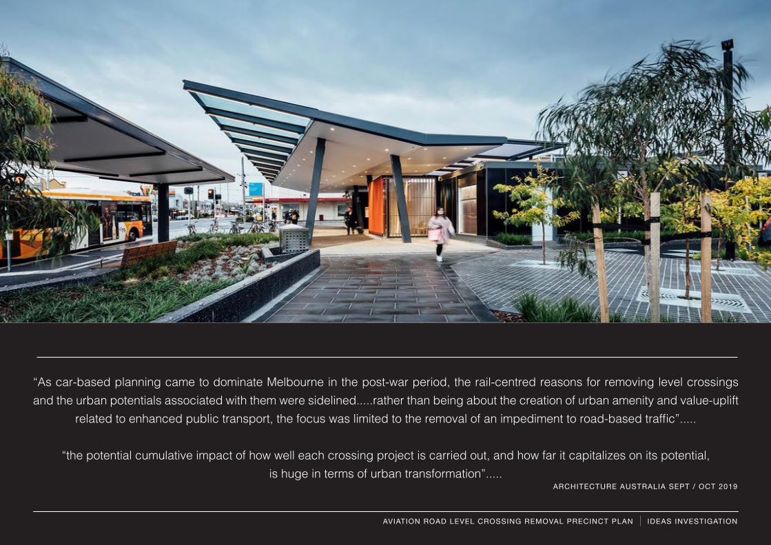
“As car-based planning came to dominate Melbourne in the post-war period, the rail-centred reasons for removing level crossings and the urban potentials associated with them were sidelined.....rather than being about the creation of urban amenity and value-uplift
related to enhanced public transport, the focus was limited to the removal of an impediment to road-based traffic”.....
“the potential cumulative impact of how well each crossing project is carried out, and how far it capitalizes on its potential, is huge in terms of urban transformation”.....
ARCHITECTURE AUSTRALIA SEPT / OCT 2019
AVIATION ROAD LEVEL CROSSING REMOVAL PRECINCT PLAN IDEAS INVESTIGATION
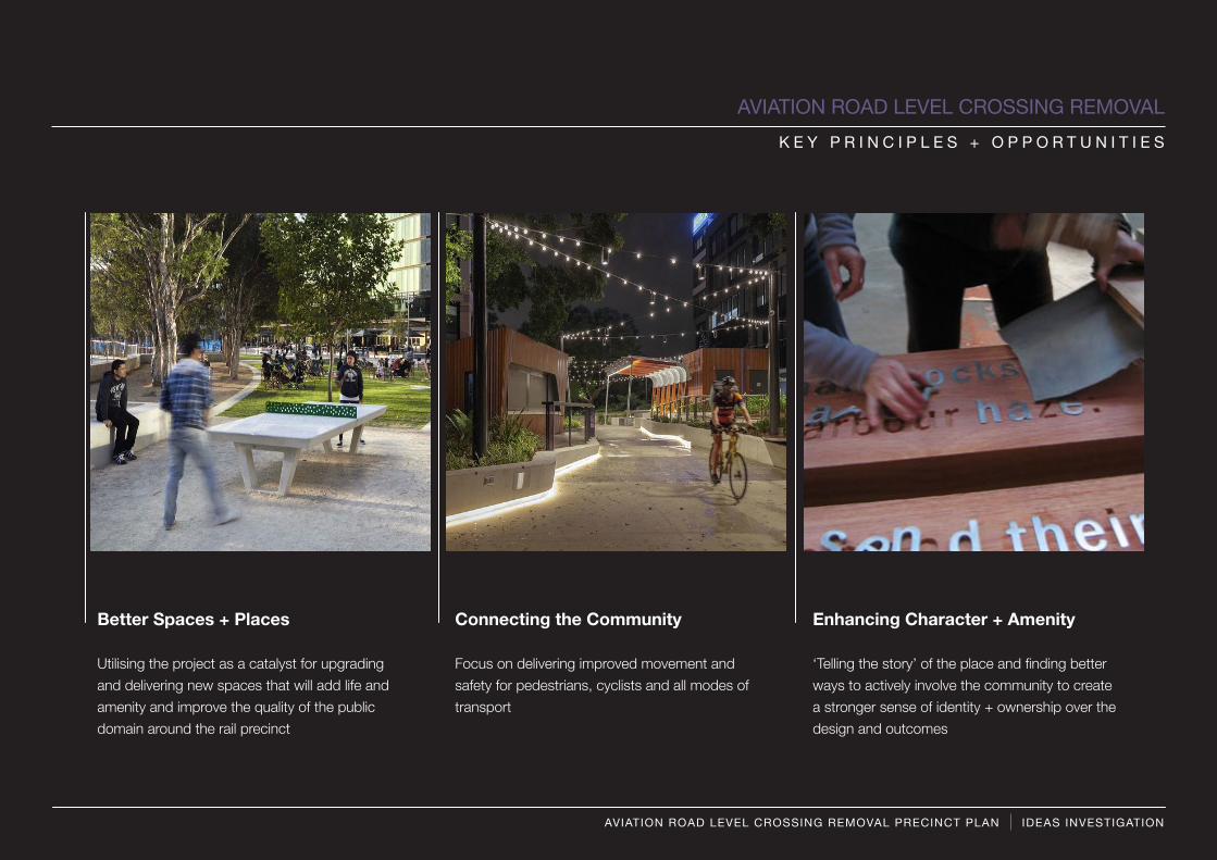
Better Spaces + Places
Utilising the project as a catalyst for upgrading and delivering new spaces that will add life and amenity and improve the quality of the public domain around the rail precinct
Enhancing Character + Amenity
‘Telling the story’ of the place and finding better ways to actively involve the community to create a stronger sense of identity + ownership over the design and outcomes
Connecting the Community
Focus on delivering improved movement and safety for pedestrians, cyclists and all modes of transport
K E Y P R I N C I P L E S + O P P O R T U N I T I E S
AVIATION ROAD LEVEL CROSSING REMOVAL
AVIATION ROAD LEVEL CROSSING REMOVAL PRECINCT PLAN IDEAS INVESTIGATION

BETTER PLACES+ SPACES
PLACES+ SPACES
• Utilising the project as a catalyst for upgrading areas surrounding the rail station to add amenity and life to the precinct
• Claiming new spaces for public use that were previously underutilised or reserved for rail and road uses
• Utilise new public spaces to improve pedestrian and cyclist connectivity into and through the precinct
• Focus on creating multiple use spaces that accommodate movement functions but also provide attractive places to sit, gather, relax and play
• Creating new spaces that could become key community destinations or focal points for the Laverton community
• Integrate design concepts and thinking with potential future upgrades to the Aviation Road shopping village - to help support the future viability and vibrancy of the precinct
KEY IDEAS + PRINCIPLES
KEY PRINCIPLESA V I A T I O N R O A D L E V E L C R O S S I N G R E M O V A L P R E C I N C T P L A N

CONNECTING THE COMMUNITY
CONNECTING• Utilise new spaces created through the level
crossing removal to provide a more integrated pedestrian and cyclist network that creates safer and more direct connections into and through the precinct
• Focus on establishing a true multi-modal hub that includes bus shelters and end of journey cycle storage etc.
• A design that prioritises active transport (public transport, walking, cycling)
• Providing visual connectivity and clear wayfinding that improves the walking and cycling experience
KEY IDEAS + PRINCIPLES
KEY PRINCIPLESA V I A T I O N R O A D L E V E L C R O S S I N G R E M O V A L P R E C I N C T P L A N
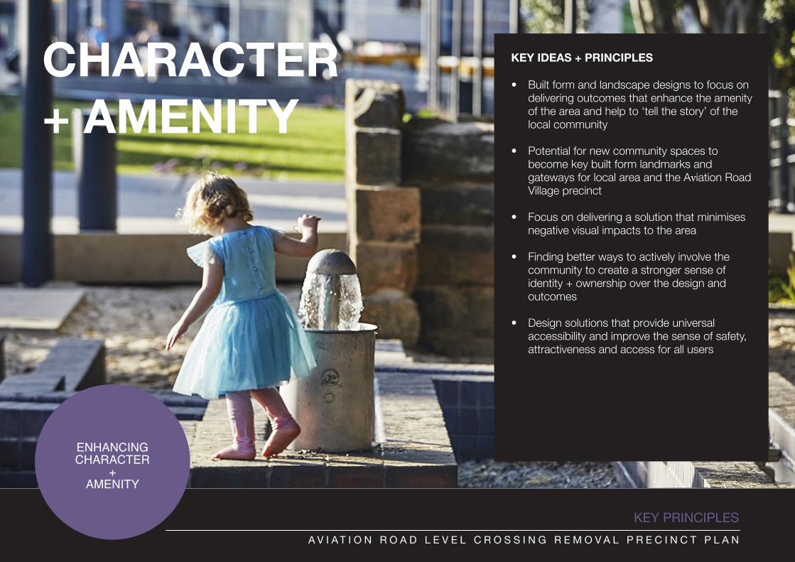
ENHANCING CHARACTER
+ AMENITY
• Built form and landscape designs to focus on delivering outcomes that enhance the amenity of the area and help to ‘tell the story’ of the local community
• Potential for new community spaces to become key built form landmarks and gateways for local area and the Aviation Road Village precinct
• Focus on delivering a solution that minimises negative visual impacts to the area
• Finding better ways to actively involve the community to create a stronger sense of identity + ownership over the design and outcomes
• Design solutions that provide universal accessibility and improve the sense of safety, attractiveness and access for all users
KEY IDEAS + PRINCIPLESCHARACTER+ AMENITY
KEY PRINCIPLESA V I A T I O N R O A D L E V E L C R O S S I N G R E M O V A L P R E C I N C T P L A N
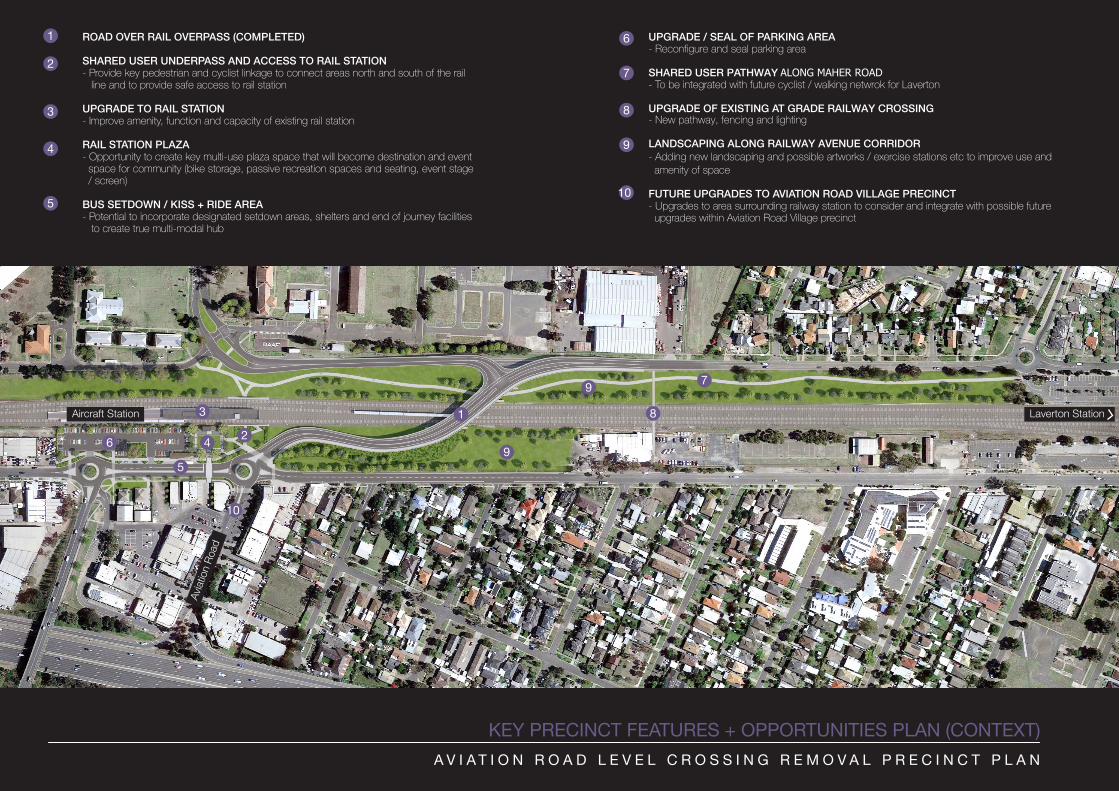
KEY PRECINCT FEATURES + OPPORTUNITIES PLAN (CONTEXT)
UPGRADE / SEAL OF PARKING AREA- Reconfigure and seal parking area
SHARED USER PATHWAY ALONG MAHER ROAD - To be integrated with future cyclist / walking netwrok for Laverton
UPGRADE OF EXISTING AT GRADE RAILWAY CROSSING - New pathway, fencing and lighting
LANDSCAPING ALONG RAILWAY AVENUE CORRIDOR- Adding new landscaping and possible artworks / exercise stations etc to improve use andamenity of space
FUTURE UPGRADES TO AVIATION ROAD VILLAGE PRECINCT- Upgrades to area surrounding railway station to consider and integrate with possible futureupgrades within Aviation Road Village precinct
ROAD OVER RAIL OVERPASS (COMPLETED)
SHARED USER UNDERPASS AND ACCESS TO RAIL STATION- Provide key pedestrian and cyclist linkage to connect areas north and south of the rail line and to provide safe access to rail station
UPGRADE TO RAIL STATION- Improve amenity, function and capacity of existing rail station
RAIL STATION PLAZA- Opportunity to create key multi-use plaza space that will become destination and eventspace for community (bike storage, passive recreation spaces and seating, event stage/ screen)
BUS SETDOWN / KISS + RIDE AREA- Potential to incorporate designated setdown areas, shelters and end of journey facilities
to create true multi-modal hub
A V I A T I O N R O A D L E V E L C R O S S I N G R E M O V A L P R E C I N C T P L A N
1
2
3
4
6
7
8
12
3
4
5
6
7
5
9
10
8
9
10
9
Aircraft Station Laverton Station
Aviat
ion R
oad
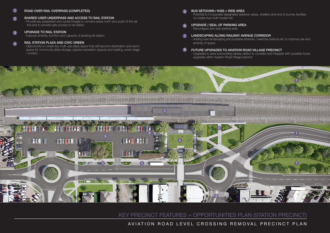
KEY PRECINCT FEATURES + OPPORTUNITIES PLAN (STATION PRECINCT)
BUS SETDOWN / KISS + RIDE AREA- Potential to incorporate designated setdown areas, shelters and end of journey facilities to create true multi-modal hub
UPGRADE / SEAL OF PARKING AREA- Reconfigure and seal parking area
LANDSCAPING ALONG RAILWAY AVENUE CORRIDOR- Adding new landscaping and possible artworks / exercise stations etc to improve use and amenity of space
FUTURE UPGRADES TO AVIATION ROAD VILLAGE PRECINCT - Upgrades to area surrounding railway station to consider and integrate with possible future upgrades within Aviation Road Village precinct
ROAD OVER RAIL OVERPASS (COMPLETED)
SHARED USER UNDERPASS AND ACCESS TO RAIL STATION- Provide key pedestrian and cyclist linkage to connect areas north and south of the rail line and to provide safe access to rail station
UPGRADE TO RAIL STATION- Improve amenity, function and capacity of existing rail station
RAIL STATION PLAZA AND CIVIC GREEN- Opportunity to create key multi-use plaza space that will become destination and event space for community (bike storage, passive recreation spaces and seating, event stage / screen)
A V I A T I O N R O A D L E V E L C R O S S I N G R E M O V A L P R E C I N C T P L A N
1
2
3
4
6
7
8
5
12
3
4
5
6
7
8
9
5 7
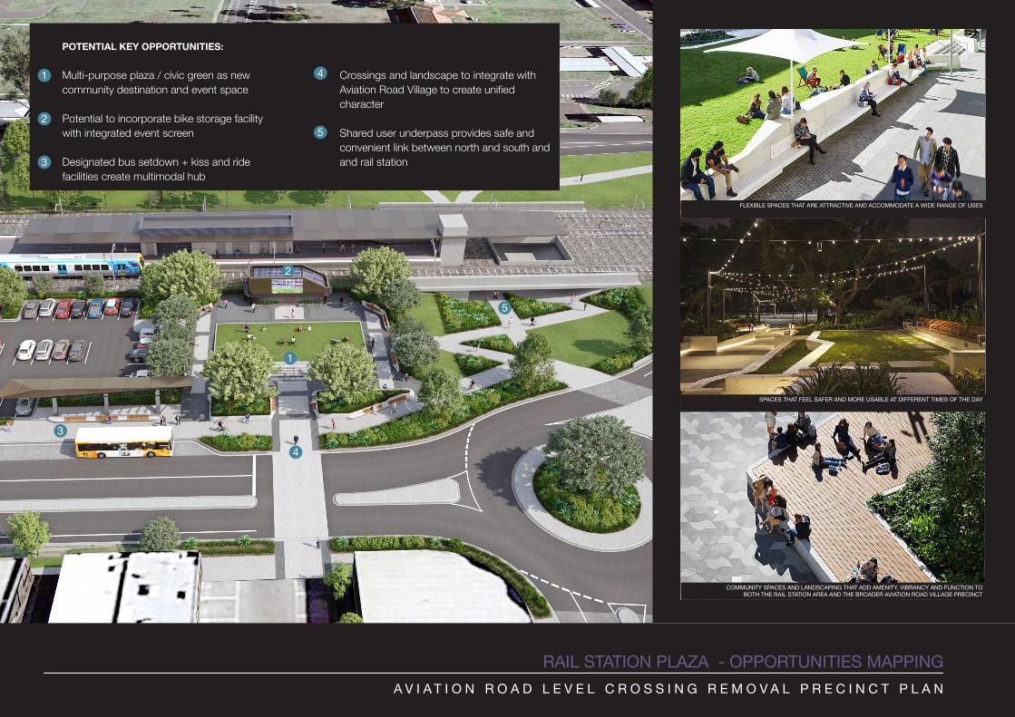
RAIL STATION PLAZA - OPPORTUNITIES MAPPING
FLEXIBLE SPACES THAT ARE ATTRACTIVE AND ACCOMMODATE A WIDE RANGE OF USES
SPACES THAT FEEL SAFER AND MORE USABLE AT DIFFERENT TIMES OF THE DAY
COMMUNITY SPACES AND LANDSCAPING THAT ADD AMENITY, VIBRANCY AND FUNCTION TO BOTH THE RAIL STATION AREA AND THE BROADER AVIATION ROAD VILLAGE PRECINCT
A V I A T I O N R O A D L E V E L C R O S S I N G R E M O V A L P R E C I N C T P L A N
POTENTIAL KEY OPPORTUNITIES:
Multi-purpose plaza / civic green as new community destination and event space
Potential to incorporate bike storage facility with integrated event screen
Designated bus setdown + kiss and ride facilities create multimodal hub
1
2
3
4 Crossings and landscape to integrate with Aviation Road Village to create unified character
Shared user underpass provides safe and convenient link between north and south and and rail station
1
2
3
4
5
5
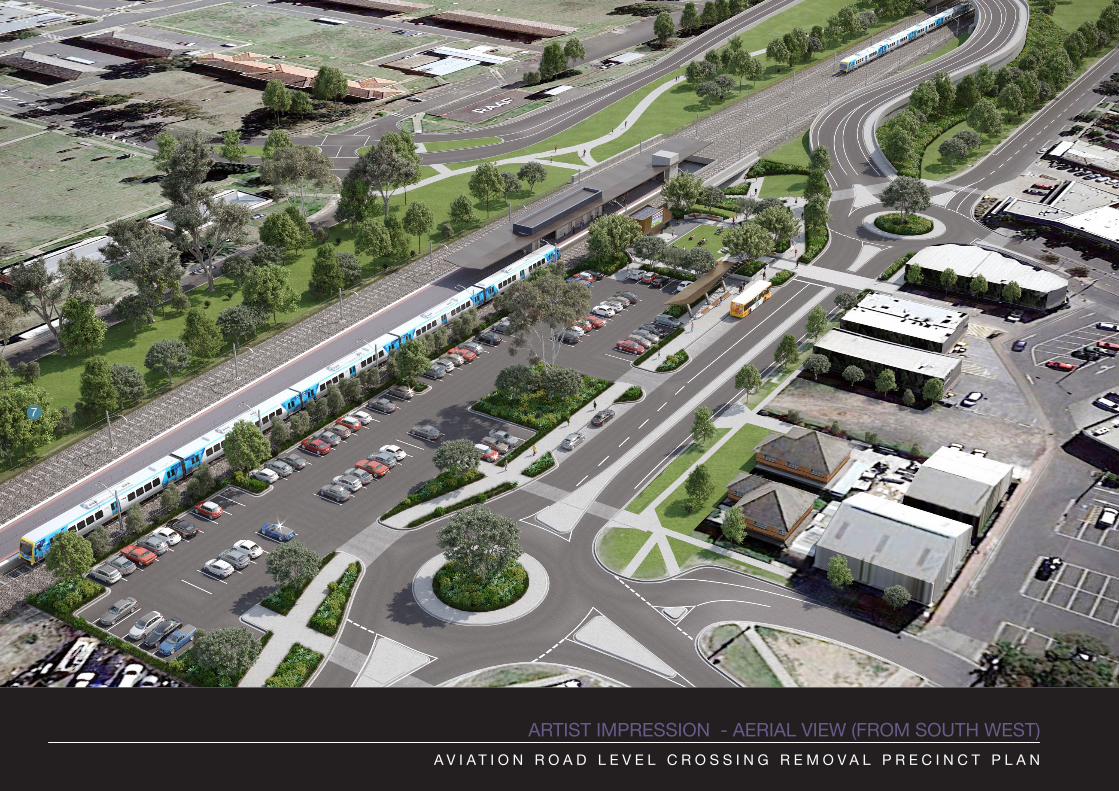
ARTIST IMPRESSION - AERIAL VIEW (FROM SOUTH WEST)A V I A T I O N R O A D L E V E L C R O S S I N G R E M O V A L P R E C I N C T P L A N
7
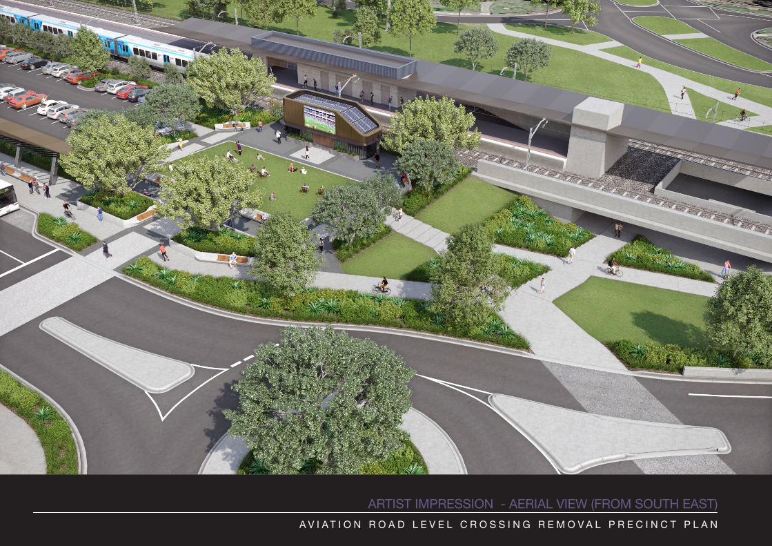
ARTIST IMPRESSION - AERIAL VIEW (FROM SOUTH EAST)A V I A T I O N R O A D L E V E L C R O S S I N G R E M O V A L P R E C I N C T P L A N
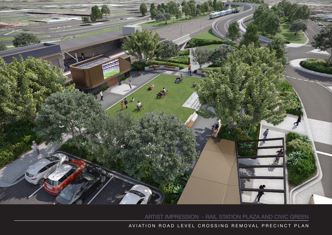
ARTIST IMPRESSION - RAIL STATION PLAZA AND CIVIC GREENA V I A T I O N R O A D L E V E L C R O S S I N G R E M O V A L P R E C I N C T P L A N
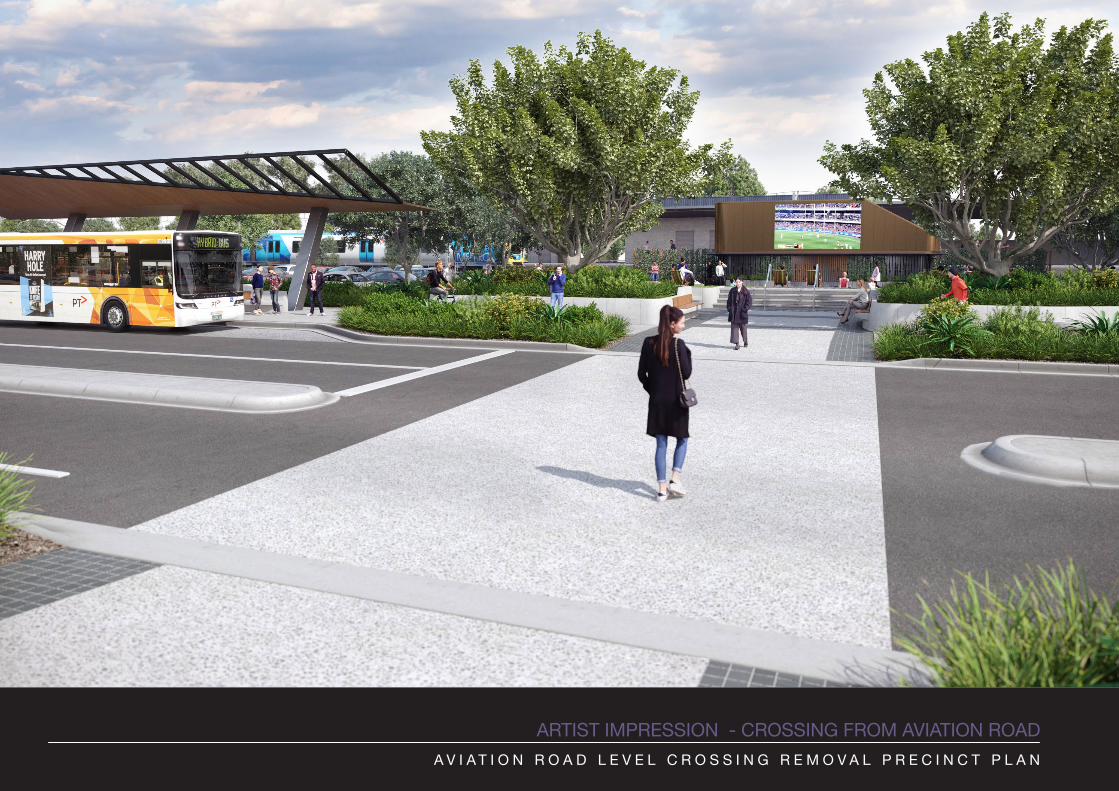
ARTIST IMPRESSION - CROSSING FROM AVIATION ROADA V I A T I O N R O A D L E V E L C R O S S I N G R E M O V A L P R E C I N C T P L A N
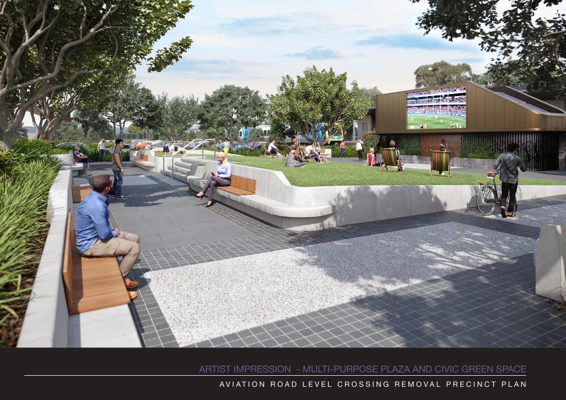
ARTIST IMPRESSION - MULTI-PURPOSE PLAZA AND CIVIC GREEN SPACEA V I A T I O N R O A D L E V E L C R O S S I N G R E M O V A L P R E C I N C T P L A N
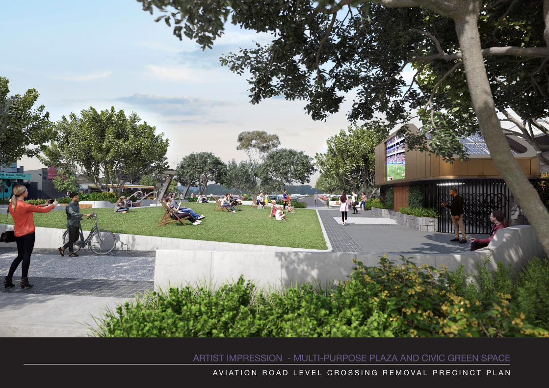
ARTIST IMPRESSION - MULTI-PURPOSE PLAZA AND CIVIC GREEN SPACEA V I A T I O N R O A D L E V E L C R O S S I N G R E M O V A L P R E C I N C T P L A N
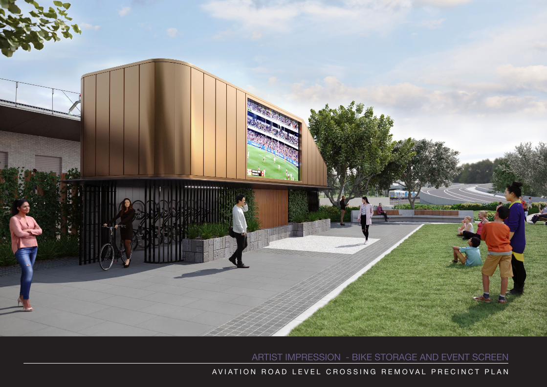
ARTIST IMPRESSION - BIKE STORAGE AND EVENT SCREENA V I A T I O N R O A D L E V E L C R O S S I N G R E M O V A L P R E C I N C T P L A N
HOBSONSBAY CITYCOUNCIL
w w w. o n e c o l l e c t i v e . c o m . a u URBAN DESIGN PLACEMAKING FUTURE LIVING LAB
This is a visioning document intended to be used for stakeholder and community dIscussion. All images have been sourced from image libraries on the internet and have copyright issues and should not be used for marketing or commercial purposes.