Embed Size (px)
Citation preview
1
Ho Chi Minh City
Ho Chi Minh City growing with water-related challenges
TRAN NGOC, T. D.1, 2 PERSET, Morgane3 STRADY, Emilie1,4 PHAN, Thi San Ha1 VACHAUD, Georges4 QUERTAMP, Fanny3 GRATIOT, Nicolas1,4
1 Centre Asiatique de Recherche sur l'Eau – CARE, Ho Chi Minh city University of Technology, VNU – HCM (Email: [email protected])
2 Faculty of Environment and Natural Resources – FENR, Ho Chi Minh city University of Technology, VNU – HCM
3 Centre de prospective et d’études urbaines – PADDI, Région Auvergne-‐Rhône-‐Alpes/HCMC People Committee/Métropole de Lyon
4 Laboratoire d’Etude des Transferts en Hydrologie et Environnement – LTHE UMR5564, Université Grenoble Alpes/CNRS/IRD
2
Part A : General context
Geography and growth evolution
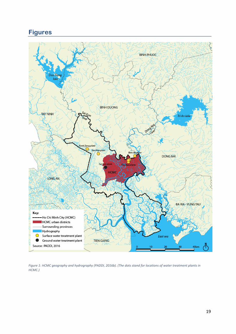
Ho Chi Minh City (HCMC), formerly Sai Gon is a lowland city located in south of Viet Nam and is crossed by the Sai Gon River. It is bordered by the lower Mekong delta on its south-‐west side and by 15 km of coastline, in front of the East Sea in the south east direction (Figure 1). The city covers a surface of 2096 km2 with a N-‐S (North-‐South) distance of ~104 km and a E-‐W (East-‐West) distance of ~47 km. The city is built up in a low land area with 65% of ground surface at less than +1.5 m above sea level.
Founded in the 17th century (administrated officially in 1698), the city emerged from an urban-‐embryo located in a deltaic plain, like other Southeast Asian and Indian megacities. Water is omnipresent in HCMC with a crisscrossing network of water bodies reported in Figure 1. This network first provided favorable conditions for water transport and trading, which enabled the city development. Also, as the city was already prone to flooding, canals allowed water drainage. In the 18th, the network of canals was improved and developed in order to increase water trading with the Lower Mekong delta region. Later on, during the French colonial occupation, from mid-‐19th to mid-‐20th, some canals were deepened and widened to allow deep-‐draft ships to navigate. The perception of urban waterways changed during the 20th century. At this period, demographic and urban pressure turned water into a critical issue for the city. As canals were used to dump waste along residential areas, French colonial authorities decided to fill all canals running inside the city center for health purposes.
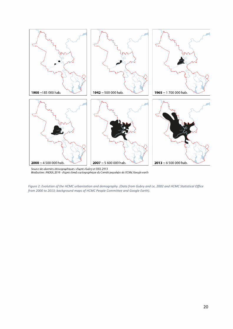
The urbanization of HCMC since the 20th century is depicted in Figure 2. From the 1950’s until late 1970’s, the city received successive waves of immigration in the context of colonial war against France, then against USA. The city experienced a 76 % demographic growth between 1945 and 1954, moving from 976000 inhabitants to 1.7 million in less than ten years (Gubry and Le, 2002), and reached 2.7 million inhabitants in 1979. In the 1990’s, after the 1986 “Đổi Mới”, an economic reform policy launched to transit to a “socialist-‐oriented” market economy, HCMC has become the main economic, industrial and tertiary center of Viet Nam.
Since 2003, HCMC is composed of 19 urban districts (“Quận”) surrounded by 5 rural districts (“Huyện”). The so-‐called ‘urban city center’ composed of inner districts and new urban areas forms an urban surface of ~600 km2 (Figure 1). According to the UN-‐definition for a city with benchmark of 10 million inhabitants, HCMC is a megacity. With an urban growth of about 3 % per year (GSO, 2013) and an economy area representing 35% of Vietnam GDP, HCMC is becoming one of the main megacities of the southeast asian region. HCMC's population is officially a census over 8 million of “hộ khẩu thường trú” (permanent resident) (after HIDS, 20141) with 81 % of urban inhabitants (living in the 19 urban districts). Nevertheless, its de
1 See PADDI. 2016a. Planification et stratégie économiques. Les Ateliers du Centre de Prospective et d'Études Urbaines, p. 29.
3
facto population is most likely more important considering an unquantified "floating population" of temporary inhabitants, workers and students (Gubry, 2014). This rapid demographic growth has a strong impact on HCMC spatial development. On average, 16 km² of its 2096 km² territory are urbanized on a yearly basis, since 2000 (Department Of Natural Resources and Environment, DONRE, 2013). The city expands filling up waterways, wetlands and converting them into urban areas (PADDI, 2014). This rapid urbanization has combined effects that need to be taken into account such as: urban fringe development, denser central core, inundation, water quality, subsidence, soil sealing.
Hydrology and related forthcoming issues
HCMC falls in tropical monsoon climate. Its annual average temperature is 27 – 28 oC. Annual average rainfall is of ~1900 mm harvested by almost 93% during rainy months from May to November. The dry months occur from December to April. HCMC is encompassed in the Dong Nai River Basin which has a total area of 38610 km2 (Figure 1). The hydrological network is composed of four main rivers: Dong Nai, Sai Gon, Nha Be and Vam Co Dong rivers. With about 8000 km of rivers, channels, and creeks, the water surface of HCMC reaches ~33500 ha, i.e. 16% of the total city area. The Dong Nai River (~890 m3/s of average flow) and Sai Gon River (~54 m3/s) are the main sources of water supply. There are 4 canal networks inside city acting as main water drainage systems: Nhieu Loc – Thi Nghe (9 km); Tau Hu – Kenh Doi – Kenh Te – Ben Nghe (25.4 km); Tan Hoa – Lo Gom (7.2 km); and Tham Luong – Ben Cat – Vam Thuat (14 km) (source: hochiminhcity.gov.vn). By the end of the 1980’s, two reservoirs have been constructed upstream of HCMC. The Dau Tieng Reservoir (storage capacity of 1.58 billion m3, built in1985) was built up on Sai Gon River and a few years later the Tri An Reservoir was built up on Dong Nai River (2.55 billion m3, 1989). These reservoirs are mainly used for irrigation (Dau Tieng) and hydroelectric power supply (Tri An). They also provide some sources of fresh water for HCMC. The regulation of their water discharge contributes to the limitation of salt intrusion from the East Sea during the dry season. The two rivers are influenced by a strongly asymmetric semi-‐diurnal tide cycle, with an average magnitude of +1.4 m for maximum water level at the Phu An station (10o46'N –106o42'E, located in District 2) on Sai Gon River (the historical tide peak of +1.68 m was recorded in 2013, source: phongchonglutbaotphcm.gov.vn). The tidal influence is a main forcing factor that leads to a maximum saline intrusion from February to May.
Sea water rising
The city is subjected to two forcing winds from the southwest (Indian Ocean) and northeast (East Sea) that blow during the rainy and dry seasons, respectively. HCMC is rarely affected by typhoon; however, the Intergovernmental Panel on Climate Change (IPCC, 2014) reported that without a very drastic reduction (50%) of emission of greenhouse gases at planetary scale, the south of Viet Nam will be probably impacted by an increase of the occurrence of typhoons and extreme rainfalls (by 10 to 20%), with a strong impact on river flow and banks erosion. There is already a clear tendency of increase for the tropical storms hitting HCMC in the last 50 years (VCAPS, 2013). The experts also pointed out that an elevation of the sea surface temperature of +5 °C or higher in the South Pacific zone will produce a possible sea-‐level rise of 0.6 to 1 m (MONRE, 2008) by the end of this century, as a result of sea-‐water dilatation (for 1/3) and melting of polar ice (for 2/3). Knowing that 65% of HCMC ground
4
surface is below +1.5 m above sea water level, HCMC ground surface and soils are facing serious flooding risks.
Soil subsidence
The quaternary topsoils of HCMC are distinguished by a transition between the Pleistocene and the Holocene for the northern -‐ northeastern parts and the southern -‐ southwestern parts, respectively. HCMC undergoes major changes driven by human-‐activities. Like Bangkok and Jakarta, HCMC is founded on a soft deltaic deposit with about 200 m thick of soft clay and sand layers (tertiary alluvial and marine soils consisting of Miocene and Pliocene formations, Tran et al., 1991) where compaction predominates, so that land subsidence is inevitable (Pham and Ta, 2015; Erkens et al., 2015). This subsidence is exacerbated in the region, as a result of intensive water pumping in groundwater for civil engineering purposes (building foundations, construction of tunnels, metro lines…), together with the large number of high-‐rise buildings (Pham and Ta, 2015; Nguyen et al., 2015). Rate of land subsidence as high as 0.44 m within 10 years were monitored in the southwestern area of the city (Pham and Ta, 2015) and confirmed locally by RADAR imagery observations (interferometry with synthetic aperture) (Ho Tong et al., 2014). Consequently, at the end of this century, the subsidence of the soil level could be of the same order of magnitude or higher than the sea-‐level rise. The relative elevation of the megacity could thus tend towards zero, or worse, become negative. The conjunction of extreme rainfall intensities, upstream river floods and downstream tide flows will certainly result in serious flooding risks threat (ADB, 2010) and possible permanent submersion of several districts of HCMC in a near future.
Drinking water
Water sources, treatment and network
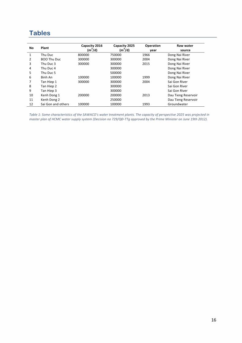
Drinking or domestic water2 has been distributed at the rate of 0.01 m3/day since 1880, from reservoirs and water towers filled mainly from groundwater. Water supply is divided into six zones in HCMC: zone 1 covering Districts 1, 3, 5 and 10; zone 2 for Districts Tan Binh and Tan Phu; zone 3 for Districts 12, Phu Nhuan, Binh Thanh and Go Vap; zone 4 for District 2, 9 and Thu Duc; zone 5 for Districts 4, 7 and Nha Be; and zone for Districts 6, 8 and Binh Tan. Domestic water is produced under the control of SAWACO (SAigon WAter COrporation), a state-‐owned company that can provide ~2.1 million m3 per day from 7 water treatment plants (their locations presented in Figure 1): 1.5 and 0.5 million m3/day of this total are pumped from surface water of Dong Nai and Sai Gon Rivers, respectively; and an additional 0.1 million m3/day extracted from groundwater (see details in Table 1).
Distributed by pipelines for a cumulated length of 5460 km, the network supplies water to ~85% of the population. Its maintenance is worrying as 80% of the network is more than 20
2 The HCMC “drinking water” supplied by the SAWACO meets the standards for domestic use as bathing/washing, but it is usually re-‐treated by micro-‐filters at households for human consumption. Unlike European and North American countries, it could not be drink directly, so that, the term “domestic water” is preferred.
5
years old (Vo, 2015; Dao, 2015). According to SAWACO, water leakage on distribution network is estimated to reach a loss of nearly 34% of the total water supply (~500000 m3/day) (in Vo, 2015). While domestic water is guaranteed for urban dwellers, only 20% of suburban dwellers have access to it. Actually, the city network has not been extended over all the areas of new inner districts and suburban districts, so that some holdhouses are using individual groundwater wells or purchase commercial water for their daily consumption. The pattern described here above clearly points out inequity in the supply of water. The city authority does intend to supply drinking water for 100% households by the end of 2016. According to the Master Plan 2025 of HCMC water supply3, the total water demand would increase by nearly two fold (3.296 million m3/day). Thus, the city should supply 3.7 million m3/day of water, 2.25 million of which coming from Dong Nai River, 1.35 million from Sai Gon River, and 0.1 million from groundwater (Table 1).
Water quality monitoring
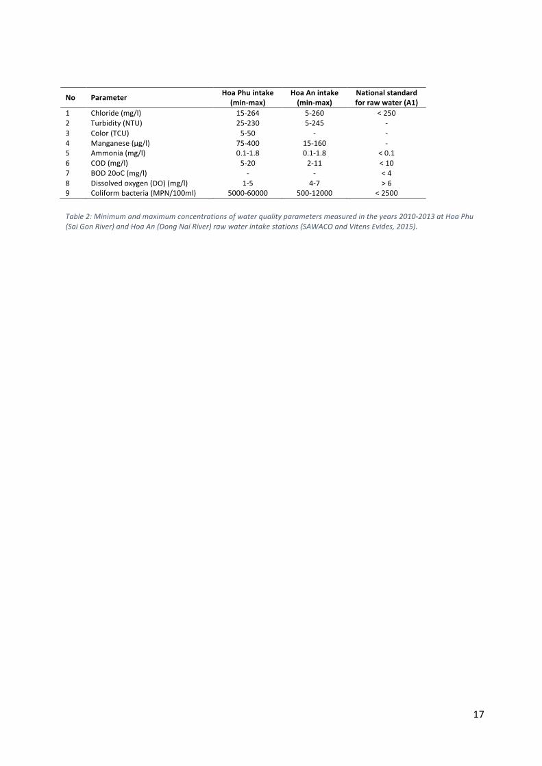
Although the HCMC is located in a well-‐watered region, fresh water shortage is occasionally occurring during the dry season. As the domestic water relies mainly on the Dong Nai and Sai Gon Rivers, the good quality of surface waters is becoming a crucial issue, in a context of severe drought, where saline intrusion is causing disrupted operation of water treatment plants and in a context of increasing industrial and urban effluents towards the rivers. SAWACO is in charge of the quality survey of the domestic water. The company focuses on the presence of parameters related to sewage effluent discharges (ammonia, COD, BOD, E.coli, total coliforms) and on the level of turbidity, chloride and manganese in water, which may impact directly the water treatment processes (Table 2, SAWACO and Vitens Evides 2015). Concerning riverine surface water quality issues, the DONRE is settling a long term monitoring program of basic parameters based on monthly sampling in several sites of the Sai Gon and Dong Nai rivers. The data being not public, it is thus difficult to state on the water quality of these two rivers. However, research projects evidenced the presence of Endocrine Disrupting Compounds (EDCs) in the two river watersheds (Le et al., 2016) and trace metals in the Saigon River (Strady et al., 2016), with systematic higher concentrations in the urban area and nearby the water treatment plant in the Saigon River. Apart from the basic parameters, emerging contaminants (e.g. urban trace metal, pesticides, EDCs, PCB, HAP, antibiotics…) should be now monitored in the surface water to ensure the quality and security of water consumption.
Groundwater uses
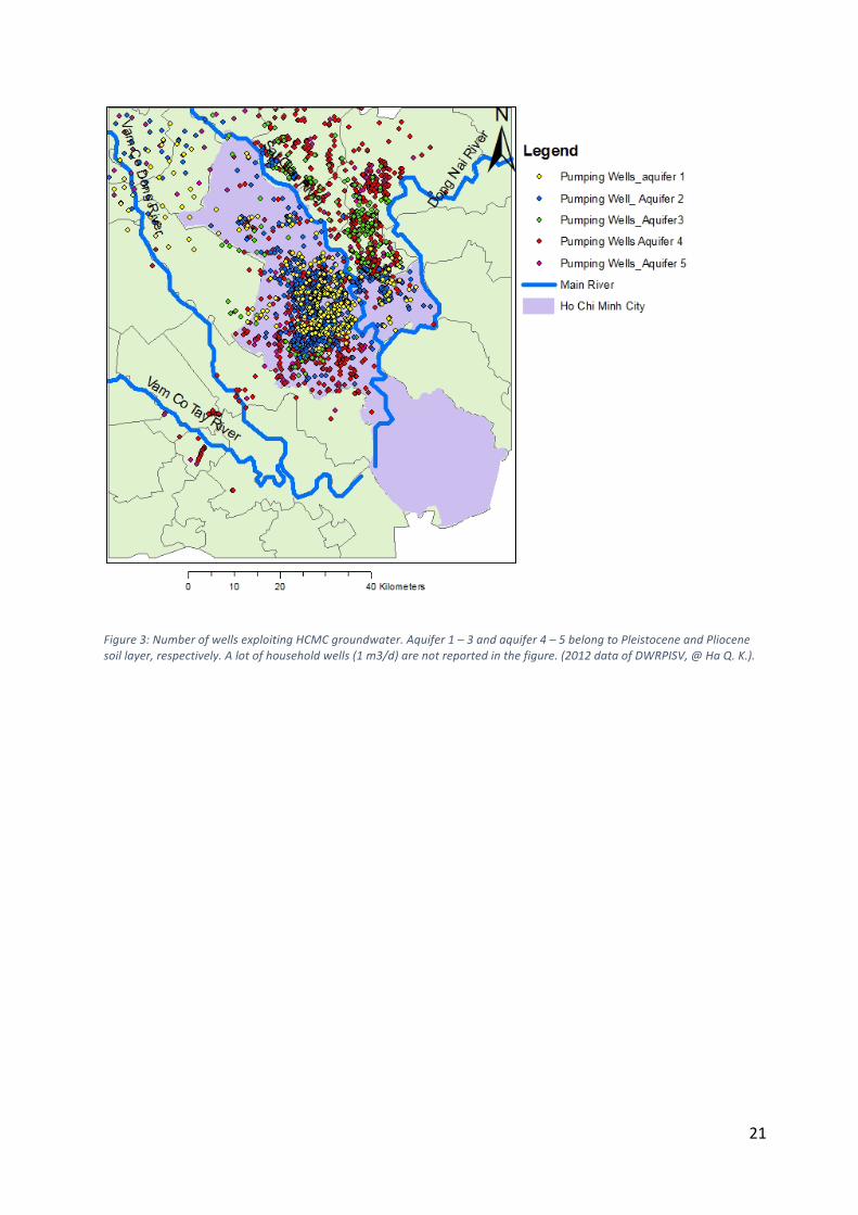
HCMC groundwater is exploitable from the Pleistocene and deeper aquifers (ancient alluvial sediments), but not from the Holocene, new alluvial sediment, which is exposed to high iron concentration and low pH in groundwater (Nguyen et al., 2007). The confined sandy aquifers of the 3 distinguishable soil types (Pleistocene, Pliocene and Miocene) are lying at average depth of 2 – 65 m, 25 – 195 m, and 110 – 282 m, respectively (Pham and Ta, 2015). Three Pleistocene aquifers are already over-‐exploited by an underestimated number of individual pumping wells (Figure 3). The average density is about 50 wells/km2 (the highest density of
3 Decision No 729/QĐ-‐TTG approved by the Prime Minister on June 19th 2012.
6
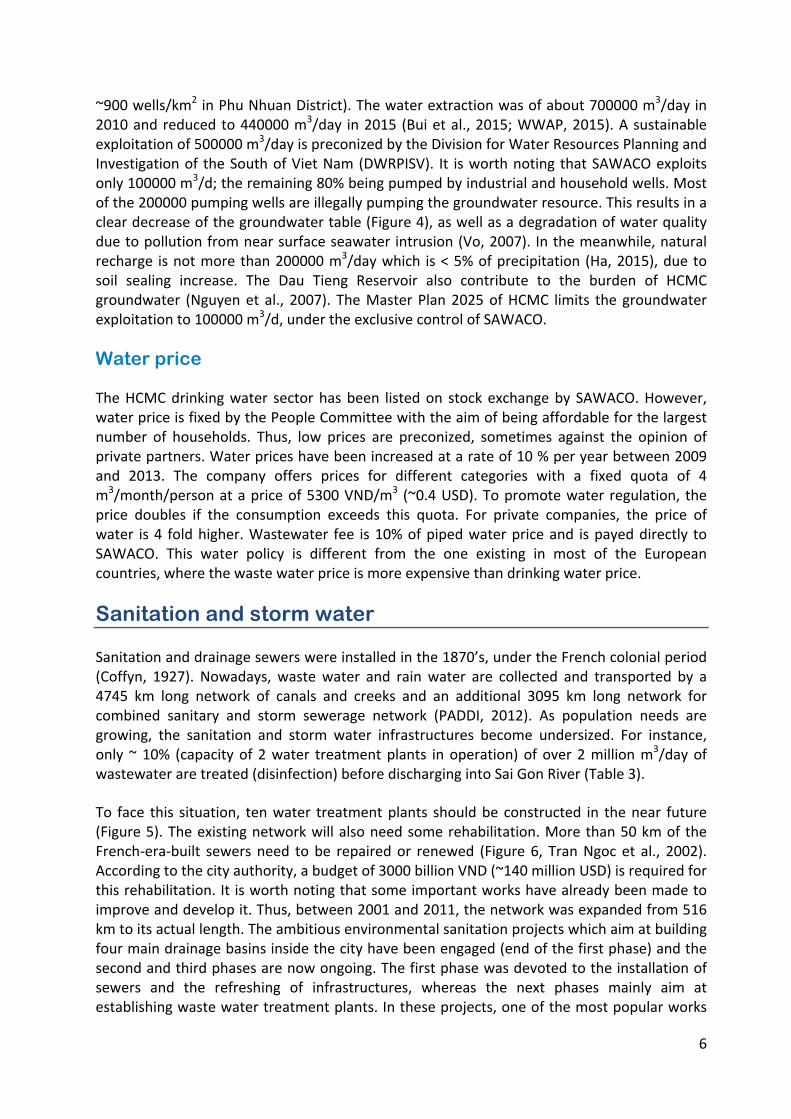
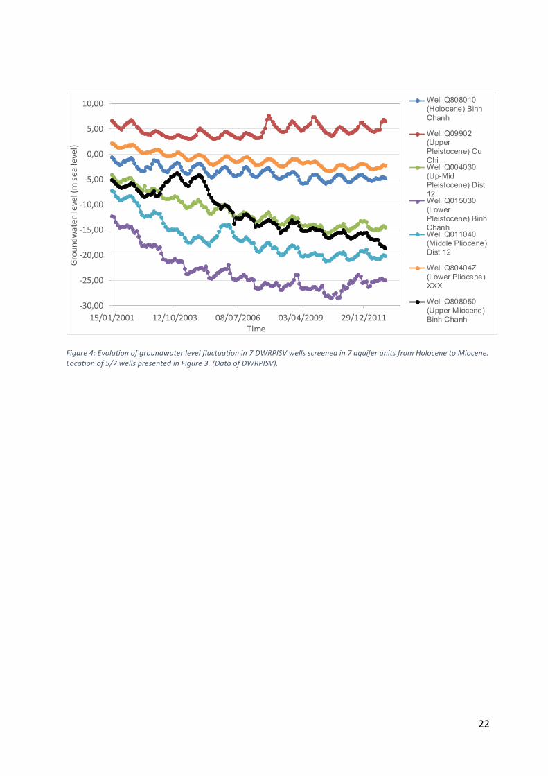
~900 wells/km2 in Phu Nhuan District). The water extraction was of about 700000 m3/day in 2010 and reduced to 440000 m3/day in 2015 (Bui et al., 2015; WWAP, 2015). A sustainable exploitation of 500000 m3/day is preconized by the Division for Water Resources Planning and Investigation of the South of Viet Nam (DWRPISV). It is worth noting that SAWACO exploits only 100000 m3/d; the remaining 80% being pumped by industrial and household wells. Most of the 200000 pumping wells are illegally pumping the groundwater resource. This results in a clear decrease of the groundwater table (Figure 4), as well as a degradation of water quality due to pollution from near surface seawater intrusion (Vo, 2007). In the meanwhile, natural recharge is not more than 200000 m3/day which is < 5% of precipitation (Ha, 2015), due to soil sealing increase. The Dau Tieng Reservoir also contribute to the burden of HCMC groundwater (Nguyen et al., 2007). The Master Plan 2025 of HCMC limits the groundwater exploitation to 100000 m3/d, under the exclusive control of SAWACO.
Water price
The HCMC drinking water sector has been listed on stock exchange by SAWACO. However, water price is fixed by the People Committee with the aim of being affordable for the largest number of households. Thus, low prices are preconized, sometimes against the opinion of private partners. Water prices have been increased at a rate of 10 % per year between 2009 and 2013. The company offers prices for different categories with a fixed quota of 4 m3/month/person at a price of 5300 VND/m3 (~0.4 USD). To promote water regulation, the price doubles if the consumption exceeds this quota. For private companies, the price of water is 4 fold higher. Wastewater fee is 10% of piped water price and is payed directly to SAWACO. This water policy is different from the one existing in most of the European countries, where the waste water price is more expensive than drinking water price.
Sanitation and storm water
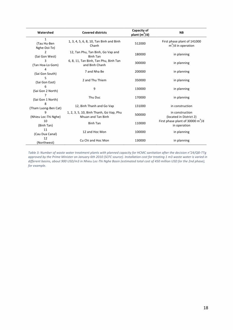
Sanitation and drainage sewers were installed in the 1870’s, under the French colonial period (Coffyn, 1927). Nowadays, waste water and rain water are collected and transported by a 4745 km long network of canals and creeks and an additional 3095 km long network for combined sanitary and storm sewerage network (PADDI, 2012). As population needs are growing, the sanitation and storm water infrastructures become undersized. For instance, only ~ 10% (capacity of 2 water treatment plants in operation) of over 2 million m3/day of wastewater are treated (disinfection) before discharging into Sai Gon River (Table 3).
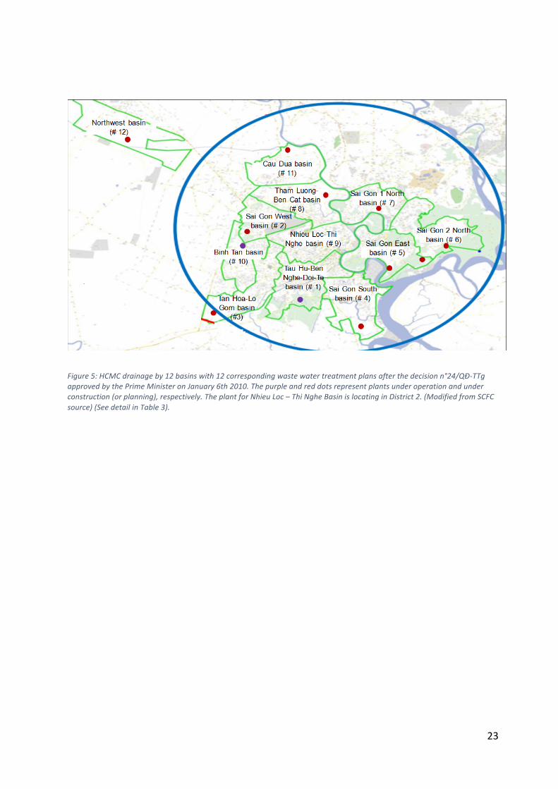
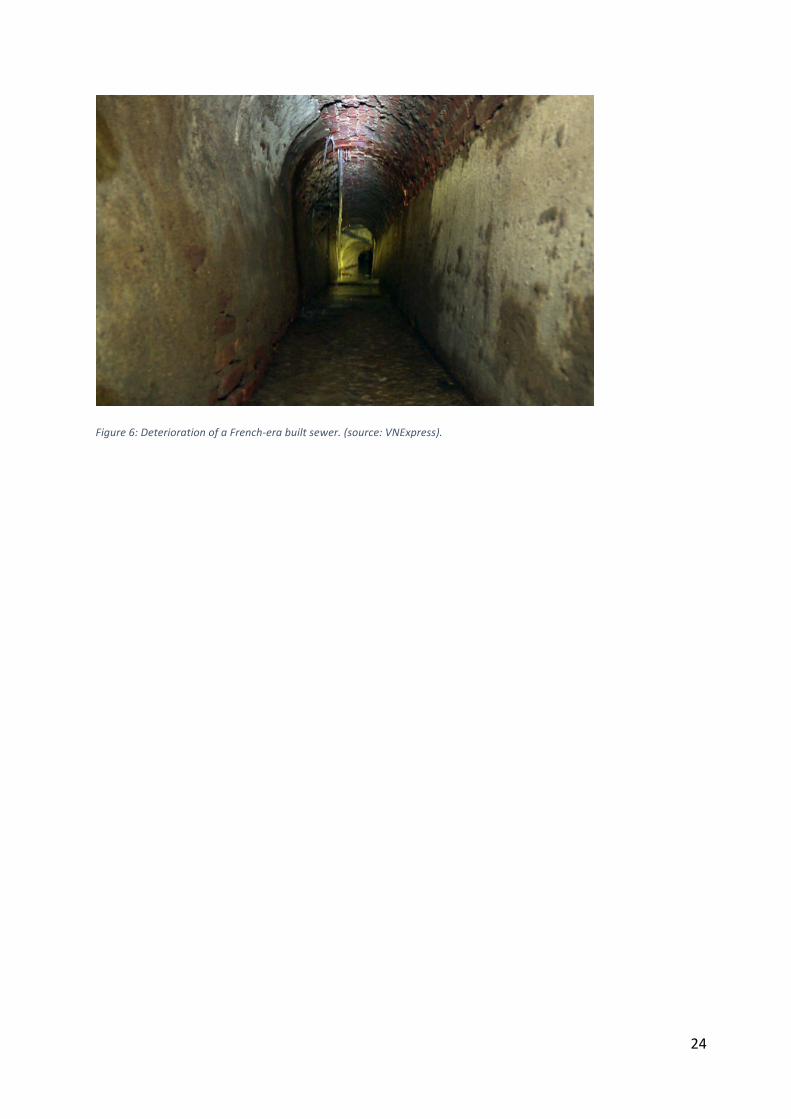
To face this situation, ten water treatment plants should be constructed in the near future (Figure 5). The existing network will also need some rehabilitation. More than 50 km of the French-‐era-‐built sewers need to be repaired or renewed (Figure 6, Tran Ngoc et al., 2002). According to the city authority, a budget of 3000 billion VND (~140 million USD) is required for this rehabilitation. It is worth noting that some important works have already been made to improve and develop it. Thus, between 2001 and 2011, the network was expanded from 516 km to its actual length. The ambitious environmental sanitation projects which aim at building four main drainage basins inside the city have been engaged (end of the first phase) and the second and third phases are now ongoing. The first phase was devoted to the installation of sewers and the refreshing of infrastructures, whereas the next phases mainly aim at establishing waste water treatment plants. In these projects, one of the most popular works
7
consists in cleaning up slums along the canals (Figure 7). This point will be detailed in section B.
During the 1990’s and 2000’s, the city authority agreed to fill up many waterways or replaced them by rectangular sewers for residential projects, Bau Cat (Tan Binh District), Van Thanh (Binh Thanh District), Binh Phu (District 6), for example. In the other hand, several cases of illegal canal occupation were reported each year, especially on drainage basins of new urban areas. According to the HCMC Company of Urban Drainage (UDC), 38% of canals and creeks managed by UDC for drainage were violated in 2012, and nearly 50% for this year (2016). Consequently, inundation is worsening in the city. In the same time, sewerage network is reducing its capacity because of a poor awareness of local people. In 2012, the UDC identified 11804 m of sewers and 306 drain-‐holes violated. A lot of collectors have been covered or sealed in front of shop houses along busy streets because of hygiene and landscape problems.
Localized urban inundation
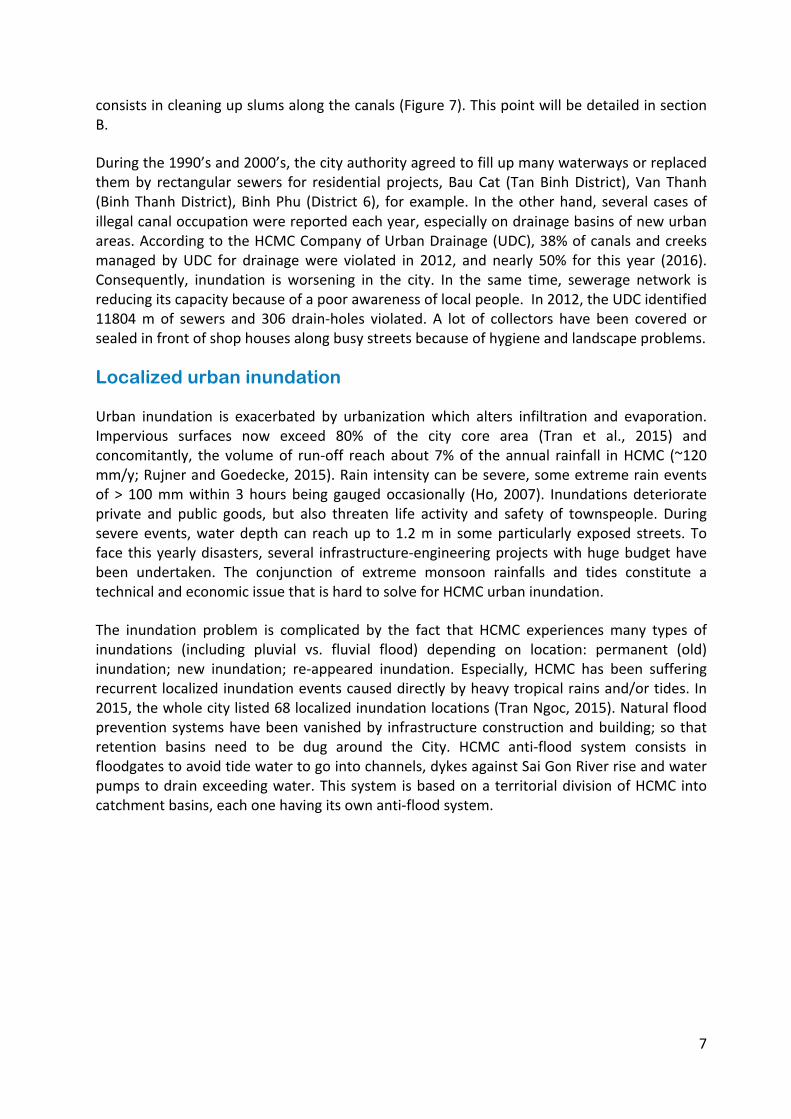
Urban inundation is exacerbated by urbanization which alters infiltration and evaporation. Impervious surfaces now exceed 80% of the city core area (Tran et al., 2015) and concomitantly, the volume of run-‐off reach about 7% of the annual rainfall in HCMC (~120 mm/y; Rujner and Goedecke, 2015). Rain intensity can be severe, some extreme rain events of > 100 mm within 3 hours being gauged occasionally (Ho, 2007). Inundations deteriorate private and public goods, but also threaten life activity and safety of townspeople. During severe events, water depth can reach up to 1.2 m in some particularly exposed streets. To face this yearly disasters, several infrastructure-‐engineering projects with huge budget have been undertaken. The conjunction of extreme monsoon rainfalls and tides constitute a technical and economic issue that is hard to solve for HCMC urban inundation.
The inundation problem is complicated by the fact that HCMC experiences many types of inundations (including pluvial vs. fluvial flood) depending on location: permanent (old) inundation; new inundation; re-‐appeared inundation. Especially, HCMC has been suffering recurrent localized inundation events caused directly by heavy tropical rains and/or tides. In 2015, the whole city listed 68 localized inundation locations (Tran Ngoc, 2015). Natural flood prevention systems have been vanished by infrastructure construction and building; so that retention basins need to be dug around the City. HCMC anti-‐flood system consists in floodgates to avoid tide water to go into channels, dykes against Sai Gon River rise and water pumps to drain exceeding water. This system is based on a territorial division of HCMC into catchment basins, each one having its own anti-‐flood system.
8
Part B : Problems, public policies and innovative solutions
Priority issues and approaches towards urban sustainability, climate change adaptation and environmental services preservation
Developing an integrated approach towards urban and environmental sustainability
With a view toward urban sustainability, climate change adaptation and environmental services preservation, HCMC is nowadays moving from an infrastructure and sector-‐oriented approach to an integrated and cross-‐disciplinary planning schemes. As the city is prone to floods, urban run-‐off, salt intrusion, soil sealing, subsidence and water pollution; water related risks are becoming the main guiding principle of urban policies. Integrated approach promotes a better coordination on multi-‐scale planning and governance levels as well as on a project level, with the systematic integration of water and environmental goals.
At a planning level, Vietnam legal framework and its local implementation in HCMC’s master plan and sectorial plans show an increasing awareness for environmental issues, the main concern being urban floods. In this line, technical departments are working on the city’s next master plan and implementing its 2015 urban renewal program entitled “virtuous urban development”. Technical departments are encouraged to develop new regulations introducing sustainable development standards into urban development policies. For example, it includes the integration of hydraulic and green spaces compensation principles into local regulations (Huynh et al., 2013). For sustainable urban drainage systems at household scale, green roof is the best measure, but needs an easy installation technology for public acceptance (Ho et al., 2015). Awareness is particularly raised on key environmental areas, such as mangrove and wetlands, which are the green lungs of the megacity and which efficiently contribute to the regulation of floods. As part of this process, the Department of Urban Planning and Architecture (DUPA) is currently working on integrating water related issues into land use plans and detailed plans, making these documents key instruments for climate change adaptation at district and project levels (PADDI, 2016a).
Urban and environmental sustainability principles are therefore developed at every territorial level, mobilizing provincial and district authorities as well as private project developers and citizens. Still at a local governance level, specific executive bodies dedicated to climate change and floods have been created under the direct supervision of HCMC People’s Committee, indicating the importance given to these topics. Created in 2008, the HCMC Steering Center for the urban Flood Control program (SCFC) is a coordination center for flood risk and waste water management. It manages sewage network, waste water treatment plants and defensive infrastructures (dykes, sluice gates, dams, etc.). Moreover, and beyond technical
9
governance, the HCMC Climate Change Bureau funded in 2012 implements, monitors and evaluates the agenda adopted by the HCMC Climate Change Steering Board (CCSB).
At a project level, hydraulic and green spaces compensation principles are planned for large scale projects. Apart for megaprojects, guidelines are defined for medium and small scale projects such as parks or individual housing. These guidelines include water-‐related issues. With the support of research centers and international cooperation agencies, HCMC technical departments are working on long term urban design solutions, particularly on a network of water retention ponds that could be used as playgrounds during dry periods. Temporary storage solutions are also promoted such as water reservoirs placed under buildings. These practical solutions, once integrated into planning documents and local regulations, will significantly contribute to the adaptation of HCMC to climate change, along with the construction of hard-‐defense structures.
Tackling climate change effects and improving urban resilience to floods with hard defense structures
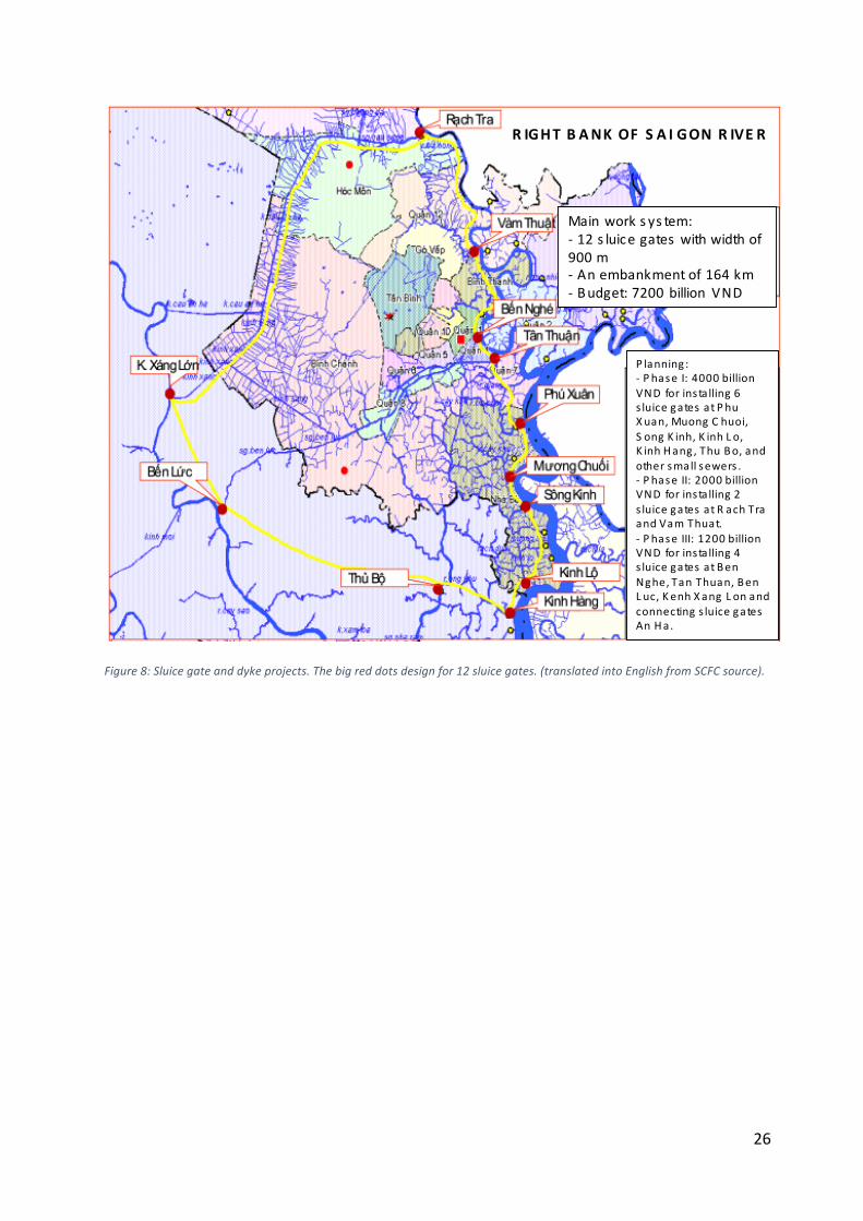
The integrated approach presented above aims at protecting the city against floods with hard defense structure, such as dykes, embankments, drainage network, water treatment plants, reservoirs, dragging, etc. Indeed, a recent decision on urban areas and industrial parks drainage displays the ambition that urban centers would be flood free in 20504, following a 2014 decision on Climate Change that focuses on flood protection improvement5. The analysis is that the HCMC 2001 Flood management plan6 and its 2008 Water resources plan for flood control7 have not yet reach their goals. The first one aimed at improving the efficiency of drainage system by 2020 whereas the second one intended to build 172 km of dykes, 12 sluice gates and to drag canals and ensure an optimal drainage (Figure 8).
In this line, HCMC People’s Committee and the SCFC are carrying out projects and programs with several cooperation agencies and multilateral donors. Since 2011, the city is working with the Japan International Cooperation Agency (JICA) on urban flood control with a project of capacity improvement of urban drainage management and a sewer rehabilitation pilot project. Both of them aim to cope with the insufficient capacity of the existing discharge facilities. In 2009, a strategic partnership was signed between the Dutch government and Viet Nam on climate change adaptation and water management. It led to the creation of the Vietnam Climate Adaptation Partnership (VCAPS) which consists of a consortium assisting HCMC in developing its local climate change strategy. HCMC also has a long-‐standing partnership with the World Bank. Since 2001, they launched two environmental sanitation projects. They include the construction of sewer lines, sewer interceptors, embankments and waste water treatment plant. Also, the multilateral donor recently came up with a proposed flood risk management project that would be implemented by the SCFC, if approved.
4 Decision n°589/QĐ-‐TTg approved by the Prime Minister on April 6th 2016.
5 Decision n°103/TB-‐VPCP approved by the Prime Minister on March 12th 2014.
6 Decision n°752/QD-‐TTg approved by the Prime Minister on June 19th 2001.
7 Decision n°1547/QD-‐TTg approved by the Prime Minister on October 28th 2008.
10
Preserving water resources to restore environmental services
Apart from improving urban resilience to floods, the other main issue which HCMC is facing is preserving the quality of surface and groundwater resources. The preservation of environmental resources is one of the five priorities of the HCMC People Committee for the next political mandate (2016 – 2020). Indeed, HCMC is highly vulnerable to salinization, water pollution and occasionally to drought periods. To tackle these challenges, the city is working on combined solutions.
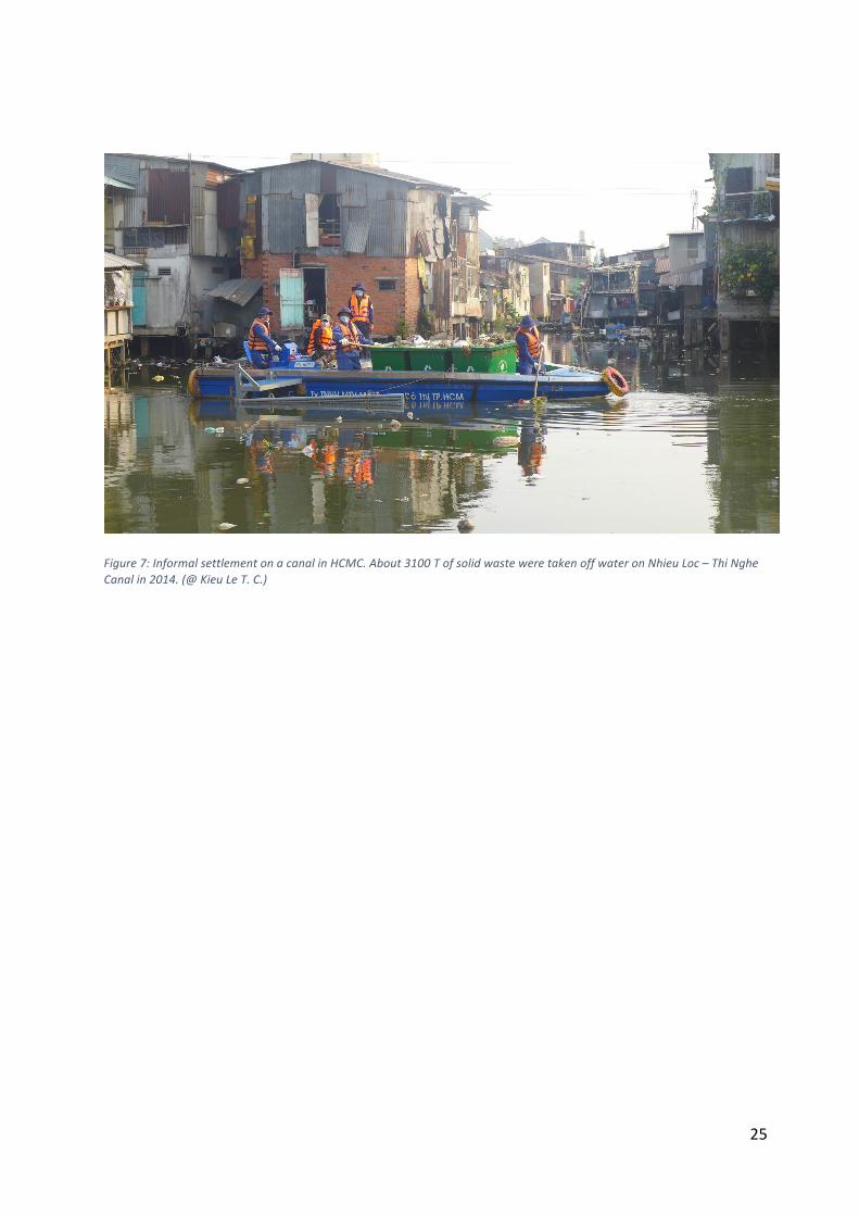
Within the last decade, the water quality of canals has been improved and partially restored, particularly in the urban city center Nhieu Loc – Thi Nghe canal thanks to the environmental sanitation project implemented by the World Bank (World Bank, 2012). The construction of a sewer interceptor and the installation of sewer lines now avoid direct wastewater release along the canal. A visual impact of the water quality transformation was also observed by local population (World Bank, 2012; Givental, 2014). In parallel, since 2012, floating waste are collected on a daily basis by the city on canals (Figure 7), an average of 10 tons per day on Nhieu Loc – Thi Nghe and 30 tons per day on Tau Hu (Lahens, 2016). To pursue the improvement of canal water quality, the city master plan now implies the relocation of industrial activities currently releasing polluted wastewater into canals.
The Dong Nai watershed and more particularly the Sai Gon River sub-‐watershed are also facing environmental issues, especially concerning water quality improvement and the prevention of saline intrusion and water level decline (van Leewen et al., 2015). Currently, the water quality monitoring program implemented by the HCMC is being revised and adapted to new challenges. Concerning saline water intrusion prevention and adapted water distribution, a project lead by the French Development Agency (AFD), with the joint effort of the Asian Development Bank (ADB), has funded the construction of a dam, a transfer canal plus another canal to redirect drinking water to the Mekong delta provinces (source: AFD.fr).
Regarding groundwater preservation, researchers have regularly alerted local authorities about preoccupying issues such as salt intrusion, the drop of groundwater table and the insufficient recharge rate. Since 2007, HCMC has promulgated a decree8 indicating areas of prohibited groundwater exploitation (almost for inner districts) and areas of limited exploitation (pipe pressure of drinking water network < 0.2 kg/cm2). Mapping of these areas are yearly updated. According to Le (2012) and Ha and Koontanakulvong (2015), the groundwater level is expected to decrease by 2 m if the pumping rate is not reduced. On the other hand, relative sea level rise is expected to increase by 1 m at the end of the century with some negative consequences on both salt intrusion and groundwater levels in the area. Possible solutions to mitigate these water-‐related risks would include: artificial groundwater recharge, regulation of groundwater pumping and regulation of water release from upstream reservoirs to repel saline intrusion in aquifers.
8 Decision n° 69/2007/QĐ-‐UBND approved by HCMC People’s Committee on May 3rd 2007.
11
Innovative solutions to adapt HCMC to water related risks
Integrating water related guidelines for new urban developments: the case of Thu Thiem new urban area
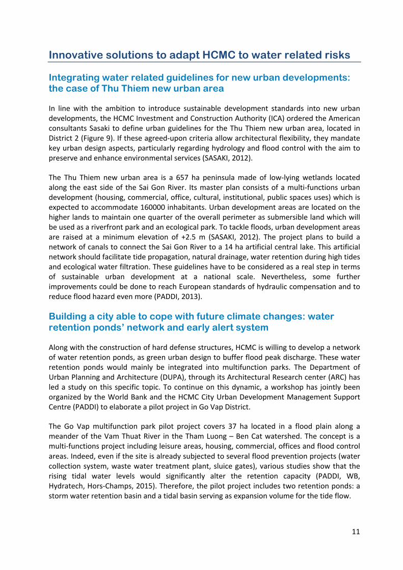
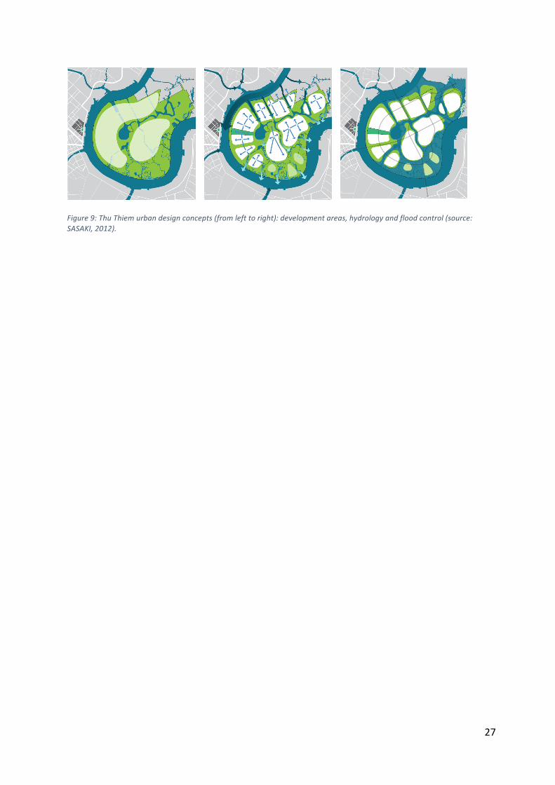
In line with the ambition to introduce sustainable development standards into new urban developments, the HCMC Investment and Construction Authority (ICA) ordered the American consultants Sasaki to define urban guidelines for the Thu Thiem new urban area, located in District 2 (Figure 9). If these agreed-‐upon criteria allow architectural flexibility, they mandate key urban design aspects, particularly regarding hydrology and flood control with the aim to preserve and enhance environmental services (SASAKI, 2012).
The Thu Thiem new urban area is a 657 ha peninsula made of low-‐lying wetlands located along the east side of the Sai Gon River. Its master plan consists of a multi-‐functions urban development (housing, commercial, office, cultural, institutional, public spaces uses) which is expected to accommodate 160000 inhabitants. Urban development areas are located on the higher lands to maintain one quarter of the overall perimeter as submersible land which will be used as a riverfront park and an ecological park. To tackle floods, urban development areas are raised at a minimum elevation of +2.5 m (SASAKI, 2012). The project plans to build a network of canals to connect the Sai Gon River to a 14 ha artificial central lake. This artificial network should facilitate tide propagation, natural drainage, water retention during high tides and ecological water filtration. These guidelines have to be considered as a real step in terms of sustainable urban development at a national scale. Nevertheless, some further improvements could be done to reach European standards of hydraulic compensation and to reduce flood hazard even more (PADDI, 2013).
Building a city able to cope with future climate changes: water retention ponds’ network and early alert system
Along with the construction of hard defense structures, HCMC is willing to develop a network of water retention ponds, as green urban design to buffer flood peak discharge. These water retention ponds would mainly be integrated into multifunction parks. The Department of Urban Planning and Architecture (DUPA), through its Architectural Research center (ARC) has led a study on this specific topic. To continue on this dynamic, a workshop has jointly been organized by the World Bank and the HCMC City Urban Development Management Support Centre (PADDI) to elaborate a pilot project in Go Vap District.
The Go Vap multifunction park pilot project covers 37 ha located in a flood plain along a meander of the Vam Thuat River in the Tham Luong – Ben Cat watershed. The concept is a multi-‐functions project including leisure areas, housing, commercial, offices and flood control areas. Indeed, even if the site is already subjected to several flood prevention projects (water collection system, waste water treatment plant, sluice gates), various studies show that the rising tidal water levels would significantly alter the retention capacity (PADDI, WB, Hydratech, Hors-‐Champs, 2015). Therefore, the pilot project includes two retention ponds: a storm water retention basin and a tidal basin serving as expansion volume for the tide flow.
12
Large-‐scale structural measures might be insufficient to solve local inundation problems. Meanwhile HCMC people are familiar with precipitation-‐driven inundation, often with a sense of fatality as there is no way offered to cope effectively with the disaster. Resilience process is not effective anymore as observed during severe inundation events. Mitigation of localized inundation requires the integration of various approaches to propose adaptation measures. In particular, urban inundation hindcasting and forecasting would be an essential tool for HCMC, allowing a better assessment of HCMC resilience capacity. Early alert system for the urban inundation forecast has to be established (Tran Ngoc, 2010 and 2015). This would improve city people’s awareness in regard to the forecast reports and warning systems, for coping actively with the intensity and irregularity of the actual weather within the context of climate change. An investigation on HCMC social perception to early alert system and inundation-‐related risks is being conducted in 2017 to get a better understanding and adaptation of local people to inundation risk.
Acknowledgments: This monography was written in the framework of the “Saigon River: la Ville et le Fleuve” (CMIRA 2015) and “Gestion durable des Eaux urbaines et Perceptions Habitantes du risque d’inondation à Ho Chi Minh – Ville (EPH2)” (Thématiques intégrées -‐ Eau et gestion des ressources naturelles) projects, funded by the Région Auvergne-‐Rhône-‐Alpes and Agence Universitaire de la Francophone, respectively. We would like to thank these partners for their financial supports.
13
References
ADB (Asian Development Bank). 2010. Ho Chi Minh City Adaptation to Climate Change. Summary Report, Mandaluyong City, Philippines.
Bui, T. V., Le, H. N. and Phan, N. L. 2015. Groundwater sustainability of Ho Chi Minh City, Viet Nam. Int. Symp. and Exhib.of Vietnam Water Coop. Initiative, Ha Noi, Viet Nam (19-‐20 October.) Coffyn, L. F. P. 1927. Note à l’appui d’un projet de la Ville de Saigon. Bouchot, J. (ed), Documents pour servir à l’Histoire de Saigon. Sai Gon, Albert Portail. Dao, T. B. V. 2015. Impacts of water stress on Ho Chi Minh City, Viet Nam. Master thesis, VGU, HCMC, Viet Nam.
DONRE (Department of Natural Resources and Environment of Ho Chi Minh City). 2013. Land use planning 2020 -‐ land use plan 5-‐year period 2011-‐2015, Ho Chi Minh City [Quy hoạch sử dụng đất đến năm 2020 -‐ kế hoạch sử dụng đất 5 năm giai đoạn 2011-‐2015, Thành Phố Hồ Chí Minh]. Report, 234 p., HCMC, Viet Nam.
Erkens, G., Bucx, T., Dam, R., de Lange, G. and Lambert, J. 2015. Sinking coastal cities. Proc. IAHS, Vol. 372, pp. 189-‐198. General Statistic Office (GSO). 2013. Statistical yearbook of Viet Nam.
Givental, E. 2014. The Ho Chi Minh City canals: assessing vulnerability and resilience factors. Asso. of Pacific Coast geographers yearbook, Vol. 76, pp. 49-‐67. Gubry, P. and Le, T. H. 2002. Ho Chi Minh City: a future megacity in Vietnam. [unpublished] Presented at the Int. Union for the Sci. Study of Population -‐ Southeast Asian Regional Conf., Bangkok, Thailand. (10-‐13 June, 2002.) Gubry, P. 2014. La génération de la population flottante dans les grandes villes vietnamiennes. Rencontres de Hanoi sur « L’expertise française au Viet Nam dans les domaines de l’urbain » (IDEFIE), Ha Noi. (27 – 28 May.) Ha, Q. K. 2015. Impact of Climate Change on groundwater recharge in Ho Chi Minh City Area. Master thesis, Chulalongkorn University, Bangkok, Thailand.
Ha, Q. K. and Koontanakulvong, S. 2015. Impact of Climate Change on groundwater recharge in Ho Chi Minh City Area, Vietnam. Int. Conf. on Climate Change and Water & Environment Management in Monsoon Asia, Bangkok, Thailand.
Ho, H. L., Babel, M. S., Weesakul, S., Irvine, K. N. and Pham M. D. 2015. Exploratory assessment of SUDS Feasibility in Nhieu Loc-‐Thi Nghe Basin, Ho Chi Minh City, Vietnam. British J. of Envir. & Climate Change, Vol 5, no 2, pp. 91-‐103, Ho L. P. 2007. Climate change and urban flooding in Ho Chi Minh City. Finish Environment Institute (ed). Proc. of Third International Conference on Climate and Water. Helsinki, pp. 194-‐199. (3 – 6, September.) Ho Tong, M. D., Le, V. T. and Le Toan, T. 2015. Mapping ground subsidence phenomena in HCMC through the radar interferometry technique using ALOS PALSAR data. Remote Sensing, Vol. 7, pp. 8542-‐8562.
Huynh, C., Eckert, R., Maikämper, M., Horst, B and Schwartze, F. 2013. Adapt-‐HCMC. Handbook on Climate Change adapted urban planning & design for Ho Chi Minh City/Viet Nam, Cottbus, Germany.
14
IPCC. 2014. Impacts, Adaptation and Vulnerability. https://www.ipcc-‐wg2.gov/AR5/
Lahens, L. 2016. Study of macroplastics and microplastics pollution in the Sai Gon River and canals in Ho Chi Minh City, Viet Nam. Master thesis, SAGE Lab., University Paris Est Créteil -‐ Ecole des ponts ParisTech, Paris, France. Le, T. M.T., Nguyen, P. D., Dinh, Q. T., Ngo, H. H., Do, H. L. C., 2016. Presence of e-‐EDCs in surface water and effluents of pollution sources in Sai Gon and Dong Nai river basin. Sustainable Environment Research, Vol. 26, no. 1, pp. 20-‐27 Le, V. T. 2012. Giải pháp GIS trong quản lý nước dưới đất khu vực TP. Hồ Chí Minh. [GIS solution in managing underground water at Ho Chi Minh City]. Tạp chí Phát Triển KH&CN, Vol 15, No M2, pp. 5-‐17. (In Vietnamese.)
MONRE (Ministry of Natural Resources and Environment). 2008. Prime Minister. National target program to respond to climate change (Decision 158/2008/QĐ-‐TTG). Ha Noi, Viet Nam.
Nguyen, K. C., Huynh, L. and Le, V. K. 2007. Use of isotope techniques to estimate recharge sources of groundwater in the upper part of Nam Bo Plain (Vietnam). International symposium on advances in isotope hydrology and its role in sustainable water resources management, HIS, Vienna, Autria. (21-‐25 May.)
Nguyen, P. D., Nguyen, T. V. H., Bui, X. T. and Le, V. K. 2007. Water resources management in Ho Chi Minh City. Institute for Global Environmental Strategies, IGES report, Kanagawa, Japan. Nguyen, T. B., Samsura, D. A. A., van der Krabben, E. and Le, A. D. 2015. City Profile Saigon-‐Ho Chi Minh City. Cities, Vol. 50, pp. 16-‐27. PADDI. 2012, Approche intégrée des risques d’inondation vers une planification d’élément systémiques. N° 38. PADDI. 2013. Mission d’assistance technique auprès de ICA Thu Thiem. PADDI. 2014. Meandering through the city, exhibition presented in March 2014 in HCMC. PADDI, WB, HYDRATECH, HORS-‐CHAMPS. 2015. Technical assistance assignment study on a multifunction park: Flood protection strategy.
PADDI. 2016a. Planification et stratégie économiques. Les Ateliers du Centre de Prospective et d'Études Urbaines. PADDI. 2016b. Ville durable : des concepts à la pratique. Pham, H. G. and Ta, T. T. 2015. Subsurface characterization and prediction of land subsidence for HCM City, Viet Nam. Eng. Geol., Vol. 199, pp. 107-‐124. Rujner, H. and Goedecke. 2016. Urban water management: Spatial assessment of the urban water balance. Katzschner et al. (eds), Sustainable HCMC: Climate polities for emerging mega cities. Heidelberg, Springer. SASAKI. 2012. Thu Thiem urban design guidelines.
SAWACO and Vitens Evides. 2015. SAWACO climate change adaptation plan. Main report, HCMC, Viet Nam. Strady, E., Dang, V. B. H., Némery, J., Guédron, S., Dinh, Q. T., Denis, H., Nguyen, P.D. 2016. Baseline seasonal investigation of nutrients and trace metals in surface waters and sediments along the Saigon River basin impacted by the megacity of Ho Chi Minh (Vietnam). Environmental Science and Pollution Research, in press, DOI: 10.1007/s11356-‐016-‐7660-‐7
15
Tran, N., Ngo, Q. T., Do, T. V. T., Nguyen, D. M., Nguyen, V. V. 1991. Quaternary sedimentary of the principal deltas of Viet Nam. J. of Southeast Asian Earth Sci., Vol. 6, No. 2, pp. 103-‐110. Tran Ngoc, T. D. et al. 2002. Khảo sát hiện trạng cống vòm TP. Hồ Chí Minh. [Surveying current status of HCMC brick sewers built in French-‐era]. UDC report, HCMC, Viet Nam. (in Vietnamese.)
Tran Ngoc, T. D. 2010. Active coping with urban inundation in Ho Chi Minh City: a forecasting solution and performance. 2nd VNU -‐ HCM Int. Conf. for Env. and Nat. Resour. -‐ Theme: “Environmental Protection for Urban and Industrial Zones in adaptation to Climate Change”, Ho Chi Minh City – Viet Nam, 318-‐323 pp. (2-‐3 December.) Tran Ngoc, T. D. 2015. Needing to forecast urban inundation events for Ho Chi Minh City (Viet Nam) resiliency. International conference on Water, Megacities and global change, UNESCO HQ, Paris, France. (1-‐4 December.) Tran, T. V., Dinh, T. K. P., Phan, Y. V. and Ha Duong, X. B. 2015. Mapping changes of surface topography under urbanization process in Ho Chi Minh City, Viet Nam, using satellite imagery. Proc. of 1st Int. Electronic Conf. on Remote Sensing. (22 June-‐5 July.) van Leeuwen, C. J., Nguyen, P. D. and Dieperinkz, C.2015. The Challenges of Water Governance in Ho Chi Minh City. Integrated Env. Assess. and Manag., Vol. 9999, No 9999, pp. 1–8.
VCAPS (Vietnam Climate Adaptation Partnership). 2013. Climate adaptation strategy for Ho Chi Minh City. Report VCAPS project (Grontmij), HCMC, Viet Nam. Vo, A. T. 2015. Nghiên cứu xác nhận nguyên nhân và đề xuất các giải pháp giảm thiểu thất thoát nước sạch cho hệ thống cấp nước đô thị TP. Hồ Chí Minh. [Studying causes and measurements for minimizing water loss of water supply systems in Ho Chi Minh City]. Ph.D. thesis, IER, VNU-‐HCM, HCMC. (In Vietnamese.) Vo, L. P. 2009. Water resource management in Ho Chi Minh City, Viet Nam: an overview. Science and Technology Development J. Vol 12, no 2, pp. 51-‐63. The University of Adelaide, Australia. World Bank. 2012. Vietnam -‐ Ho Chi Minh City Environmental Sanitation (Nhieu Loc-‐Thi Nghe Basin) Project. Washington DC. http://documents.worldbank.org/curated/en/2012/12/17151849/vietnam-‐ho-‐chi-‐minh-‐city-‐environmental-‐sanitation-‐nhieu-‐loc-‐thi-‐nghe-‐basin-‐project
WWAP (United Nations World Water Assessment Programme). 2015. Facing the challenges. Case Studies and Indicators. UNESCO, Paris, France.
16
Tables
No Plant Capacity 2016 (m3/d)
Capacity 2025 (m3/d)
Operation year
Raw water source
1 Thu Duc 800000 750000 1966 Dong Nai River 2 BOO Thu Duc 300000 300000 2004 Dong Nai River 3 Thu Duc 3 300000 300000 2015 Dong Nai River 4 Thu Duc 4
300000
Dong Nai River
5 Thu Duc 5
500000
Dong Nai River 6 Binh An 100000 100000 1999 Dong Nai River 7 Tan Hiep 1 300000 300000 2004 Sai Gon River 8 Tan Hiep 2
300000
Sai Gon River
9 Tan Hiep 3
300000
Sai Gon River 10 Kenh Dong 1 200000 200000 2013 Dau Tieng Reservoir 11 Kenh Dong 2
250000
Dau Tieng Reservoir
12 Sai Gon and others 100000 100000 1993 Groundwater
Table 1: Some characteristics of the SAWACO’s water treatment plants. The capacity of perspective 2025 was projected in master plan of HCMC water supply system (Decision no 729/QĐ-‐TTg approved by the Prime Minister on June 19th 2012).
17
U
No Parameter Hoa Phu intake (min-‐max)
Hoa An intake (min-‐max)
National standard for raw water (A1)
1 Chloride (mg/l) 15-‐264 5-‐260 < 250 2 Turbidity (NTU) 25-‐230 5-‐245 -‐ 3 Color (TCU) 5-‐50 -‐ -‐ 4 Manganese (μg/l) 75-‐400 15-‐160 -‐ 5 Ammonia (mg/l) 0.1-‐1.8 0.1-‐1.8 < 0.1 6 COD (mg/l) 5-‐20 2-‐11 < 10 7 BOD 20oC (mg/l) -‐ -‐ < 4 8 Dissolved oxygen (DO) (mg/l) 1-‐5 4-‐7 > 6 9 Coliform bacteria (MPN/100ml) 5000-‐60000 500-‐12000 < 2500
Table 2: Minimum and maximum concentrations of water quality parameters measured in the years 2010-‐2013 at Hoa Phu (Sai Gon River) and Hoa An (Dong Nai River) raw water intake stations (SAWACO and Vitens Evides, 2015).
18
Watershed Covered districts Capacity of plant (m3/d) NB
1 (Tau Hu-‐Ben Nghe-‐Doi-‐Te)
1, 3, 4, 5, 6, 8, 10, Tan Binh and Binh Chanh 512000 First phase plant of 141000
m3/d in operation
2 (Sai Gon West)
12, Tan Phu, Tan Binh, Go Vap and Binh Tan 180000 in planning
3 (Tan Hoa-‐Lo Gom)
6, 8, 11, Tan Binh, Tan Phu, Binh Tan and Binh Chanh 300000 in planning
4 (Sai Gon South) 7 and Nha Be 200000 in planning
5 (Sai Gon East) 2 and Thu Thiem 350000 in planning
6 (Sai Gon 2 North) 9 130000 in planning
7 (Sai Gon 1 North) Thu Duc 170000 in planning
8 (Tham Luong-‐Ben Cat) 12, Binh Thanh and Go Vap 131000 in construction
9 (Nhieu Loc-‐Thi Nghe)
1, 2, 3, 5, 10, Binh Thanh, Go Vap, Phu Nhuan and Tan Binh 500000 in construction
(located in District 2) 10
(Binh Tan) Binh Tan 110000 First phase plant of 30000 m3/d in operation
11 (Cau Dua Canal) 12 and Hoc Mon 100000 in planning
12 (Northwest) Cu Chi and Hoc Mon 130000 in planning
Table 3: Number of waste water treatment plants with planned capacity for HCMC sanitation after the decision n°24/QĐ-‐TTg approved by the Prime Minister on January 6th 2010 (SCFC source). Installation cost for treating 1 m3 waste water is varied in different basins, about 900 USD/m3 in Nhieu Loc-‐Thi Nghe Basin (estimated total cost of 450 million USD for the 2nd phase), for example.
19
Figures
Figure 1: HCMC geography and hydrography (PADDI, 2016b). (The dots stand for locations of water treatment plants in HCMC.)
20
Figure 2: Evolution of the HCMC urbanization and demography. (Data from Gubry and Le, 2002 and HCMC Statistical Office from 2000 to 2013; background maps of HCMC People Committee and Google Earth).
21
Figure 3: Number of wells exploiting HCMC groundwater. Aquifer 1 – 3 and aquifer 4 – 5 belong to Pleistocene and Pliocene soil layer, respectively. A lot of household wells (1 m3/d) are not reported in the figure. (2012 data of DWRPISV, @ Ha Q. K.).
22
Figure 4: Evolution of groundwater level fluctuation in 7 DWRPISV wells screened in 7 aquifer units from Holocene to Miocene. Location of 5/7 wells presented in Figure 3. (Data of DWRPISV).
-‐30,00
-‐25,00
-‐20,00
-‐15,00
-‐10,00
-‐5,00
0,00
5,00
10,00
15/01/2001 12/10/2003 08/07/2006 03/04/2009 29/12/2011
Groundwater le
vel (m sea level)
Time
Well Q808010(Holocene) BinhChanh
Well Q09902(UpperPleistocene) CuChiWell Q004030(Up-MidPleistocene) Dist12Well Q015030(LowerPleistocene) BinhChanhWell Q011040(Middle Pliocene)Dist 12
Well Q80404Z(Lower Pliocene)XXX
Well Q808050(Upper Miocene)Binh Chanh
23
Figure 5: HCMC drainage by 12 basins with 12 corresponding waste water treatment plans after the decision n°24/QĐ-‐TTg approved by the Prime Minister on January 6th 2010. The purple and red dots represent plants under operation and under construction (or planning), respectively. The plant for Nhieu Loc – Thi Nghe Basin is locating in District 2. (Modified from SCFC source) (See detail in Table 3).
24
Figure 6: Deterioration of a French-‐era built sewer. (source: VNExpress).
25
Figure 7: Informal settlement on a canal in HCMC. About 3100 T of solid waste were taken off water on Nhieu Loc – Thi Nghe Canal in 2014. (@ Kieu Le T. C.)
26
Figure 8: Sluice gate and dyke projects. The big red dots design for 12 sluice gates. (translated into English from SCFC source).
Main work s ys tem:-‐ 12 s luice gates with width of 900 m-‐ An embankment of 164 km-‐ Budget: 7200 billion VND
R IGHT B ANK OF S A I GON R IVE R
P lanning :-‐ P hase I: 4000 billion VND for insta lling 6 s luice gates at P hu X uan, Muong C huoi, S ong K inh, K inh L o, K inh Hang , Thu Bo, and other small sewers .-‐ P hase II: 2000 billion VND for insta lling 2 s luice gates at R ach Traand Vam Thuat.-‐ P hase III: 1200 billion VND for insta lling 4 s luice gates at Ben Nghe, Tan Thuan, Ben L uc, K enh Xang L on and connecting s luice gatesAn Ha.
27
Figure 9: Thu Thiem urban design concepts (from left to right): development areas, hydrology and flood control (source: SASAKI, 2012).