Embed Size (px)
Citation preview

HISTORY OF WEATHER OBSERVATIONS
Mobile, Alabama 1820-2004
July 2005
Prepared by: Stephen R. Doty
Information Manufacturing Corporation Rocket Center, West Virginia
Prepared in cooperation with: Robert D. Erhardt, Jr.
Assistant State Climatologist for Alabama U.S. Army Corps of Engineers
Mobile, Alabama
This report was prepared for the Midwestern Regional Climate Center under the auspices of the Climate Database Modernization Program, NOAA’s National Climatic Data Center, Asheville, North Carolina
i

CONTENTS Acknowledgements iii List of Illustrations iv Introduction Executive Summary 1 Goal of Study 1 Location of Observations Location maps 2 Chronology of Locations and Elevations 3 Observers and Instrumentation Mobile 6 Mobile Point 35 Dauphin Island 37 Appendices Appendix 1, Observer Story – Solomon Mordecai, MD 39 Appendix 2, Methodology 40 References and Data Sources 41
ii

ACKNOWLEDGEMENTS
The author would like to thank Rob Erhardt, Assistant Alabama State Climatologist, for his valuable help in locating historical information used in the preparation of this report. His enthusiasm for learning about the rich weather observing history of Mobile was infectious.
Ms. Elisa Baldwin, the archivist at the University of South Alabama Archives, went the extra mile to find historic photographs. The challenge was to find those photographs that showed weather instruments.
The author would also like to thank Glen Conner and Gary Grice for their advice and direction as it concerned the formulation of this report and its contents. And a special thanks to Joe Elms and the staff of the Climate Database Modernization Program at the National Climatic Data Center for their support and assistance.
iii

LIST OF ILLUSTRATIONS Maps Page 1. The location of the weather observing sites in the Mobile, Alabama
area from 1820 until 2004. 2 2. The locations of weather observing sites in downtown Mobile,
Alabama, 1859-1953. 3 3. The location of Fort Morgan on Mobile Point, Alabama 36 4. The location of Fort Gaines on Dauphin Island, Alabama. 37 Figures 1. A view of St. Michaels Street in Mobile, Alabama, circa 1915. 8 2. A drawing of South Royal Street in Mobile, Alabama, circa 1870’s. 9 3. The Battle House in Mobile, Alabama, prior to it burning in 1905. 10 4. The “new” Manser Building in Mobile, Alabama, circa 1890. 12 5. The United States Customs House in Mobile, Alabama, circa 1890. 14 6. The City Bank Building in Mobile, Alabama, circa 1910. 15 7. A view of North Royal Street in Mobile, Alabama, circa 1915 17 8. A ground view of the weather instruments atop the First National Bank
Building in Mobile, Alabama, circa 1930’s. 18 9. An aerial view of the First National Bank building roof top location
for the weather instruments in Mobile, Alabama, circa 1930’s. 19 10 The layout of the weather instruments in October 1936 located on the
roof of the U. S. Court House and Customs House in Mobile, Alabama. 20 11. A view of the U. S. Court House and Customs House in Mobile,
Alabama, circa 1936, as it faced St. Joseph Street. 21 12. A view of the weather instruments on the roof of the U. S. Court House
and Customs House in Mobile, Alabama, circa 1936. 21 13. The June 1953 skyline of Mobile, Alabama showing the location of the
wind instruments and the former location of the Weather Bureau offices and instrument shelter in the U. S. Court House. 22
14. William Tilson, Mobile’s chief meteorologist closes the downtown office on 1 May 1953. 23
15. Bates Field in Mobile, Alabama, circa 1936. 25 16. The location of weather instruments at the Administration Building
on Bates Field in Mobile, Alabama, November 1934. 26 17. The location of the Guard and Fire Building on Bates Field, Mobile,
Alabama, 19 June 1941. 27 18. A diagram of the Mobile, Alabama, airport, January 1942. 29 19. The temporary Administration Building on Bates Field, Mobile,
Alabama, 25 January 1942. 30 20. The layout of the weather instruments at the Administration Building,
Bates Field in Mobile, Alabama, in February 1950. 31 21. The Automated Surface Observing System at the Mobile Regional
iv

Airport, Alabama, February 1996. 33 22. A diagram of the Mobile Regional Airport as of 1995. 34 23. Fort Morgan, Alabama, circa 2000. 36 24. Fort Gaines, Alabama, circa 2000. 38 25. Silhouette of Solomon Mordecai cut in Philadelphia in 1820. 39
v

HISTORY OF WEATHER OBSERVATIONS Mobile, Alabama
1820 – 2004
Stephen R. Doty Information Manufacturing Corporation
INTRODUCTION Executive Summary
Weather observations in Mobile, Alabama, were recorded as early as 1820 as the U.S. Army established a presence at Fort Charlotte. Over the next four decades observations were taken at several different sites but the exact locations remain a mystery. In August 1869 observations were recorded west of downtown on Dauphin Way between Lafayette and Ann Streets but subsequent observations returned to the downtown district. Between 1870 and 1953 the locations were all with in a space of five blocks generally situated along Royal Street. These locations included the Manser Buildings, the Battle House, the U.S. Custom House, the City Bank Building, the First National Bank Building, and the U.S. Court House and Customs. The last observation recorded downtown was in May 1953.
In 1934 weather observations were begun at Bates Field, now known as Brookley Field. They continued at this location until December 1941 with the move to the new Bates Field west of town. Observations continue to this day at what is now known as the Mobile Regional Airport.
Sporadic observations were recorded by U.S. Army surgeons at Fort Morgan located at the mouth of Mobile Bay. These observations were taken for the overall period 1822 through 1852 but there are many gaps in the record as the Fort cycled through periods of activity and inactivity. Army surgeons also recorded observations on Dauphin Island at Fort Gaines. Only a few months of data are available from 1822 and 1868-69. Goal of Study
The goal of this study is to simply document the Mobile, Alabama, weather observers, their location and surroundings, and the instruments they used. Throughout the research for and preparation of this study, the goal was to produce a document that future studies can use to evaluate the validity of the data that were collected here, judge the trustworthiness of the observers who collected them, and determine the climatological significance of whatever variability may be discerned.
1

LOCATION OF OBSERVATIONS Location Maps North
Map 1. The location of the weather observing sites in the Mobile, Alabama area from 1820 until 2004.
2

North
Map 2. The locations of weather observing sites in downtown Mobile, Alabama, 1859-1953.
Chronology of locations and elevations
The following lists the chronology of weather station locations in and around Mobile, Alabama, 1820 until 2004: Mobile 1820 – Elevation approximately 10 feet - 30° 41’ N, 88° 02’W - Fort Charlotte located on what is now known as 104 Theatre Street 1823 – 1824 – Elevation approximately 10 feet – 30° 41’ N, 88° 02’ W - Royal Street 1840 – 1843 – Elevation approximately 10 feet – 30° 41’ N, 88° 02’ W - 92 Royal Street (1839) and 4 Government Street (1842) 1859 – Elevation approximately 30 feet - Springhill Institute and St. Mary’s Church at unknown address 1860’s – Elevation unknown - Merchants Reading Room at unknown address
3

August 1869 – February 1870 - Elevation approximately 25 feet – 30° 41’ N, 88° 04’W
- Dauphin Way between Lafayette and Ann Streets November 1870 – May 1872 – Elevation approximately 10 feet – 30° 41’ N, 88° 02’ W
- 48 St. Michaels Street May 1872 – November 1880 – Elevation approximately 10 feet
– Manser Building at the corner of Government and Royal Streets November 1880 – November 1881 –Elevation 11 feet – 30° 41’ N, 88° 02’ W
- Battle House at the corner of Royal and St. Francis Streets November 1881 – July 1884 – Elevation approximately 10 feet – 30° 41’ N, 88° 02’ W
- New Manser Building at the corner of Government and Royal Streets July 1884 –September 1905 – Elevation 11 feet – 30° 41’ N, 88° 02’ W
- Customs House at the corner of Royal and St. Francis Streets September 1905 – November 1913 – Elevation 11 feet – 30° 41’ N, 88° 02’ W
- City Bank Building at 12-14 St. Joseph Street November 1913 – November 1936 – Elevation 11 feet - 30° 42’ N, 88° 02’ W - New addition, First National Bank Building, 12-14 St. Joseph Street November 1936 – May 1953 – Elevation 10 feet – 30° 42’ N, 88° 03’ W
- U. S. Court House and Customs House at the corner of St. Louis and St. Joseph Streets
November 1934 – June 1941 – Elevation 26 feet – 30° 38’ N, 88° 04’ W
- Original Bates Field (now known as Brookley Field) Administration Building June 1941 – December 1941 –Elevation 21 feet - 30° 38’ N, 88° 04’ W
- Original Bates Field (now known as Brookley Field) Guard and Fire Building December 1941 – February 1950 –Elevation 212 feet - 30° 41’ N, 88° 14’ W
- Bates Field Terminal Building February 1950 – February 1996 – Elevation 211 feet - 30° 41’ N, 88° 15’ W
- Bates Field (now known as Mobile Regional Airport) Terminal Building February 1996 – December 2004 – Elevation 209 feet – 30° 41’ N, 88° 15’ W
- Mobile Regional Airport grounds
4

Mobile Point October 1822 – October 1852 – Elevation less than 10 feet - 30° 14’ N, 88° 01’ W - Fort Morgan Dauphin Island 1822, March 1867 – January 1868 – Elevation less than 10 feet - 30° 15’ N, 88° 05’ W - Fort Gaines
5

OBSERVERS AND INSTRUMENTATION Mobile: 1820: The earliest weather observations in Mobile were taken by U. S. Army surgeons at Fort Charlotte. The fort, originally known as Fort Conde when built by the French, was located at what is now known as 104 Theatre Street. 1823 – 1824:
Dr. Solomon Mordecai was taking weather observations in Mobile as early as 1823. He lived on Royal Street. No further details have been found. 1840 – 1843:
Dr. Stephen B. North was taking weather observations in Mobile during the early 1840’s. The 1839 Mobile City Directory listed him as a “surgeon dentist” with offices at 92 Royal Street. The 1842 City Directory listed his address as 4 Government Street. By the time of the 1844 City Directory, Dr. North was listed as a “druggist” with offices at 35 Government Street and a residence at 61 Claiborne. No further details have been found. 1859:
Rev. Joseph J. Nicholson, an Episcopal minister, was a Smithsonian Institution volunteer observer. He was the Rector at St. Mary’s Church according to the 1859 Mobile City Directory and was the Principal of the Springhill Institute. The exact location of St. Mary’s Church has not yet been determined though it seems to be in the Summerville area several miles west of downtown Mobile. No further details have been found. 1860’s: Observations were printed in the Mobile newspaper off and on during the Civil War. The location was listed as the Merchants Reading Room. The exact location of the Room is not known but the 1861 City Directory lists a Merchants Exchange at 37 St. Michaels Street. One Smithsonian Institution observational record was found for June 1866 taken by Father A. Cornette who was at Springhill College. What is most interesting (and puzzling) is a note written by L. B. Taylor, the next observer in town, which stated “I am indebted to Father Cornette S.F. at the College of Spring Hill for the report of the month of June not having gotten ready in time and not having the facilities he has for the ???
6

observations.” The first observational record now available for L. B. Taylor is August 1869, so why the large gap in time? Are the records lost or did he not take them until three years later, we may never know the answer. The inventory of available weather records created by the National Archives and Records Administration in 1942 indicates that observations were taken in Mobile between June 1868 and December 1872. To date these records have not been located. 1869 – 1870:
Records are available from August 1869 until February 1870 as taken by Lewis Boyer Taylor a Smithsonian Institution volunteer observer. Mr. Taylor was the chief clerk for the Internal Revenue Service in Mobile. He lived on the north side of Dauphin Way between Lafayette and Ann Streets in 1870. Thermometer – Smithsonian, no other details are known. Wind instruments – Smithsonian, no other details are known.
Rain gage – Smithsonian, no other details are known. It is interesting to note that Mr. Taylor had not received his rain gage at the time he began observing. His note entered on his first observational form of August 1869 shows his need for a gage.
“It is to be greatly regretted the Department cannot furnish as asked with a proper Rain Gauge. The fall of rain having been this month unusually heavy and I have no means of ascertaining the quantity. Were at possible I would like to have one sent me.” Signed L. B. Taylor
On 9 October 1869, Mr. Taylor noted on his observational form “no gage yet received.” However, by the 23rd of the month he was recording rainfall amounts. No further mention about the gage was found.
1870 – 1872:
Sergeant A. R. Thornett of the U. S. Army Signal Service established a weather station in Mobile at 48 St. Michael Street in November 1870. Figure 1 shows what the building in the area would have looked like. Observations commenced on 7 November 1870. An assistant for Sergeant Thornett, Private William Lion, arrived on station on 18 May 1871. The office remained at this location until 1 May 1872.
7
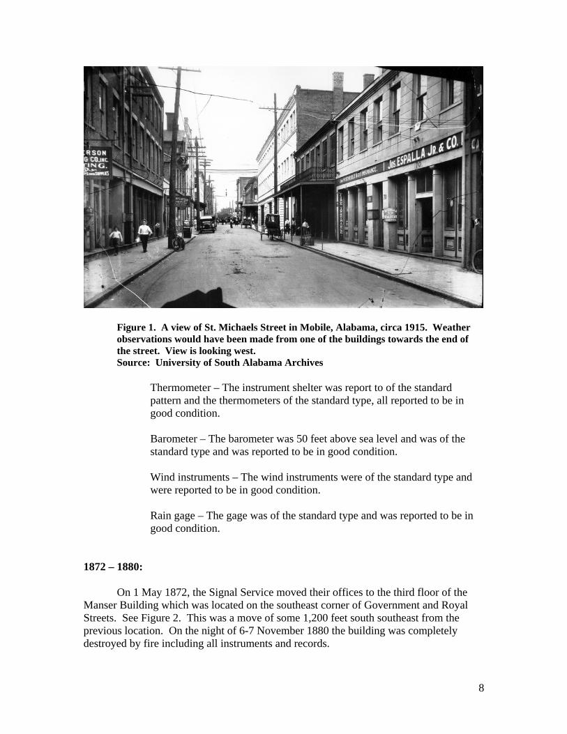
Figure 1. A view of St. Michaels Street in Mobile, Alabama, circa 1915. Weather observations would have been made from one of the buildings towards the end of the street. View is looking west.
Source: University of South Alabama Archives
Thermometer – The instrument shelter was report to of the standard pattern and the thermometers of the standard type, all reported to be in good condition.
Barometer – The barometer was 50 feet above sea level and was of the standard type and was reported to be in good condition.
Wind instruments – The wind instruments were of the standard type and were reported to be in good condition.
Rain gage – The gage was of the standard type and was reported to be in good condition.
1872 – 1880:
On 1 May 1872, the Signal Service moved their offices to the third floor of the Manser Building which was located on the southeast corner of Government and Royal Streets. See Figure 2. This was a move of some 1,200 feet south southeast from the previous location. On the night of 6-7 November 1880 the building was completely destroyed by fire including all instruments and records.
8

Figure 2. A drawing of South Royal Street in Mobile, Alabama, circa 1870’s. View is looking north. The building on the right with the ironwork balcony is the original Manser Building . Source: University of South Alabama Archives
Thermometer – The instrument shelter was of the standard Smithsonian design and was mounted in a north facing window some 14 feet above the roof. The bottom of the shelter was covered with a lattice-work to guard against radiation from the roof below.
Barometer – It is assumed that the barometer was of the standard design, probably the same barometer as the previous location, but no precise information on this has been found.
Wind instruments – The station was equipped with a large wind-vane and a self-registering anemometer mounted on the roof of the building. The instruments were well exposed.
9

Rain gage – A standard gage was mounted on the roof of the building. The gage was well exposed.
1880 – 1881:
After the destruction of the Manser Building, the Signal Service offices were moved to the Battle House on 18 November 1880. This location was at the corner of Royal and St. Francis Streets some 800 feet north northwest of the previous location. See Figure 3. Observations were made from this location until 1 November 1881.
Figure 3. The Battle House in Mobile, Alabama, prior to it burning in 1905. View is looking southeast. Source: University of South Alabama archives.
10

Thermometer – The instrument shelter was located in a window facing 16 degrees west of north at such a height that the thermometers were located 64.1 feet above sea level.
Barometer – Information on the barometer has not been found. On 1 April 1880, a barometer, serial number 380, was installed at 68.91 feet above sea level.
Wind instruments – The anemometer was located 97.9 feet above the ground and the wind vane was at 86.6 feet above the ground.
Rain gage – The tipping-bucket gage was located 84.5 feet above the ground.
1881 – 1884:
The Signal Service observing site was moved back to the previous location upon the rebuilding of the Manser Building on 1 November 1881. This was on the southeast corner of Government and Royal Streets. See Figure 4. The offices remained at this location until 1 July 1884.
11

Figure 4. The “new” Manser Building in Mobile, Alabama, circa 1890. Notice the wind vane on the roof. View is looking southeast, Government Street runs to the left of the drawing. Source: University of South Alabama archives.
Thermometer – The instrument shelter was located in a window facing 16 degrees west of north at such a height that the thermometers were located 35.8 feet above sea level. The following was extracted from Special Papers of the Alabama Weather Service, No. 1, Record of the Weather from 1701 to 1885, by Captain W. H. Gardner of Mobile, Page 13. “The high temperature recorded at Mobile in 1881-83 and 1884 is thus accounted for. The Signal Service office was then located in the third story of the Manser building, and the instrument shelter was placed opposite a north window, which was kept closed, and only two feet above the broad, tin-covered roof of a verandah. After 3 o’clock in the evening the sun’s full power was felt on the tin roof at such an angle as reflected its greatest heat towards the instrument shelter, and there being no circulation
12

through the window, a local temperature of two or three degrees above that of the atmosphere was recorded.”
Barometer – Barometer serial number 380 remained in use but the location is unknown.
Wind instruments – The anemometer was located 63.8 feet above the ground and the wind vane was at 73.8 feet above the ground.
Rain gage - The tipping-bucket gage was located 51.0 feet above the ground.
1884 – 1905:
On 1 July 1884, the Signal Service office was moved to the U. S. Customs House at the southwest corner of Royal and St. Francis Streets, a move of 800 feet north northwest. See Figure 5. The offices were located on the second floor until 10 October 1892, when they were moved to the third floor. The observations were taken from this location until August 1905. It must be noted that the U. S. Weather Bureau took over the observational duties in January 1892.
The exposure of the instruments on the roof was influenced by a live chimney 22 feet southeast. Other chimneys were located 32 feet to the north, 29 feet to the southwest, and 36 feet to the northwest. A large ventilator was 32 feet to the west. Small chimneys were located over 70 feet away southeast and northeast, and small ventilators between 50 and 60 feet north and northwest.
13

Figure 5. The United States Customs House in Mobile, Alabama, circa 1890. View is looking southwest. Source: University of South Alabama Archives.
Thermometer – The “standard pattern” instrument shelter was located on the south side of the roof near the center of the building. The floor of the shelter was 10.6 feet above a 20x20 foot platform making the instruments 87.4 feet above the ground.
Barometer – The barometer, serial number 380, was located at 35 feet above sea level until it was moved to the new third floor location in October 1892. The height was listed as 57.40 feet above sea level at this new location. On 13 November 1893, a new barometer, serial number 440, was installed. On 1 January 1897, another barometer, serial number 352, was placed into operation.
Wind instruments – The anemometer was located on the roof 95.8 feet above the ground and 19.3 feet above the roof. The wind vane was 97.1 feet above the ground and 20.6 feet above the roof. In November 1892 the anemometer, serial number 457, was replaced with another anemometer, serial number 425.
14

Rain gage – The tipping-bucket gage was located on the roof 79.4 feet above the ground and two and nine tenths feet above the roof.
1905 – 1913:
The Weather Bureau moved to the sixth floor of the City Bank Building at 12-14 St. Joseph Street on 1 September 1905. See Figure 6. The offices, rooms 603-605, were located in the southwest corner of the building. The office and instruments remained at this location until November 1913.
Several live chimneys were located near the instrument shelter including one 77 feet to the east, one 82 feet to the northeast, and one 81 feet to the north. Records indicate there were no ventilators in the vicinity. In 1907, the Van Antwerp Building was completed. It was some 150 feet high and was located 450 feet southeast of the City Bank Building.
Figure 6. The City Bank Building in Mobile, Alabama, circa 1910. The building fronts on St. Joseph Street. View is looking northeast. Source: University of South Alabama archives.
Thermometer – Initially the “standard pattern” instrument shelter was five and seven-tenths feet above the roof and approximately 83.7 feet above the ground. On 1 September 1906, the shelter was raised to a height of 10.5 feet above the roof and 98.5 feet above the ground.
15

Barometer – The barometer, serial number 352, was located 83.75 feet above sea level.
Wind instruments – The anemometer was located on the roof 94.8 feet above the ground and seven feet above the roof until 1 September 1906 when the height changed to 18.1 feet above the roof and 106.1 feet above the ground. The wind vane was located on the roof 99.8 feet above the ground and 12 feet above the roof until 1 September1906, when the height changed to 19.3 feet above the roof and 107.2 feet above the ground.
Rain gage – The tipping-bucket gage was located on the roof 90.8 feet above the ground and three feet above the roof.
1913 – 1936:
The office was again moved on 1 November 1913 to a new eight story addition to the City Bank Building, now known as the First National Bank Building, on St. Joseph Street. See Figure 7. This was a move of some 225 feet to the south. The Weather Bureau offices were located on the eighth floor, rooms 823-825, in the southeast corner of the building. The offices and instruments remained at this location until January 1936. The instruments were actually located at the “rear” of the building on the Royal Street side. See Figures 8 and 9.
Possible obstructions to the instruments included a live chimney some 56 feet to the southwest and 70 feet lower than the level of the shelter. The only building near the instruments was the Van Antwerp Building which was 225 feet south. The Merchants Bank Building, which was completed in the fall of 1929, was 240 feet high and approximately 600 feet northwest.
16

Figure 7. A view of North Royal Street in Mobile, Alabama, circa 1915. The photograph shows the relationship between the Battle House (to left), the Customs House (to right) and the First National Bank (second building on right) all sites of weather observing. Source: University of South Alabama Archives
17

Figure 8. A ground view of the weather instruments atop the First National Bank Building in Mobile, Alabama, circa 1930’s. St. Joseph Street is to the left and Dauphin Street to the right. View is looking northeast. Source: University of South Alabama Archives.
18

Figure 9. An aerial view of the First National Bank building roof top location for the weather instruments in Mobile, Alabama, circa 1930’s. View is looking north. Source: University of South Alabama archives.
Thermometer – The “standard pattern” instrument shelter was located on the roof inside the 40 foot wind instrument tower. See Figure 9. The floor of the shelter was eight and three-tenths feet above the roof and 124.8 feet above the ground. The tower, to which the shelter was attached, was eight feet from the Royal Street wall of the building and six feet from the south wall. In October 1933 the shelter was raised one foot making the height above the roof nine and three-tenths feet and the height above the ground 125.8 feet.
Barometer – The barometer was located at 107.65 feet above sea level. The barometer, serial number 352, was replaced by another barometer, serial number 1784, on 17 March 1933.
Wind instruments – The anemometer was on the top of the 40 foot wind tower at a height of 44.6 feet above the roof and 160.7 feet above the ground. The wind vane was 46.1 feet above the roof and 162.2 feet above the ground.
Rain gage – The rain gage was located a few feet from the center of the front section of the roof which was approximately 50 feet wide and 72 feet long. The top of the gage was three and a half feet above the roof and 118.9 feet above the ground.
19

Other instruments – The station was also equipped with a triple register. 1936 – 1953:
On 1 January 1936, the Weather Bureau moved to a new location in the United States Court House and Customs House located at southwest corner of St. Joseph and St. Louis Streets. See Figures 10 through 13. The offices, rooms 513-520, were located in the southeast corner of the top floor of the building. The office was closed on 1 May 1953, being consolidated with the airport office in an economy move. See Figure 14. The site became an official Weather Bureau Cooperative observer site at this time using many of the same instruments.
The closest live chimney to the instrument site was 52 feet south and about level with the top of the instrument shelter. The elevator penthouse roof, also about level with the shelter, was 14 feet southwest.
Figure 10 The layout of the weather instruments in October 1936 located on the roof of the U. S. Court House and Customs House in Mobile, Alabama. Source: Official station history files at the National Climatic Data Center.
20

Figure 11. A view of the U. S. Court House and Customs House in Mobile, Alabama, circa 1936, as it faced St. Joseph Street. View is to the west. Source: Official station history files at the National Climatic Data Center.
Figure 12. A view of the weather instruments on the roof of the U. S. Court House and Customs House in Mobile, Alabama, circa 1936. Source: Official station history files at the National Climatic Data Center.
21

Figure 13. The June 1953 skyline of Mobile, Alabama showing the location of the wind instruments and the former location of the Weather Bureau offices and instrument shelter in the U. S. Court House. The view is looking northeast. Source: Official station history files at the National Climatic Data Center.
22

Figure 14. William Tilson, Mobile’s chief meteorologist closes the downtown office on 1 May 1953.
Source: The Mobile Register
Thermometer – The “standard pattern” instrument shelter was atop a 10 foot high steel support attached to the wooden platform on the roof. The dry-bulb thermometer was 85.5 feet above the ground.
23

Barometer – The barometer, number 1784, was located 70.75 feet above sea level.
Wind instruments – The anemometer and the wind vane were mounted on a pole set on a platform on top of the penthouse roof. The anemometer was 19.5 feet above the penthouse roof and 105.2 feet above the ground. The wind vane was 21.3 feet above the penthouse roof and 107 feet above the ground. The penthouse roof was 11.8 feet above the main roof.
On 8 October 1936, the anemometer and wind vane were re-installed in the former location on the top of the First National Bank Building due to a wiring problem. The Merchants National Bank Building, which was 428 feet southeast of the wind vane, affected directions and velocities with true northwest winds. The top of this building was approximately 60 feet above the elevation of the wind instruments which lead to a decrease in the recorded velocity when winds were from the northwest. The instruments were returned to the previous location at the Court House in March 1944.
The construction of the Waterman Building in 1948, 400 feet south southeast, spoiled the exposure of the wind instruments. See Figure 13. On 28 October 1948, the anemometer and wind vane were moved to the roof of the Waterman Building. The anemometer was now 247.6 feet above the ground and the wind vane was 249 feet above the ground. There were no obstructions at this location.
Rain gage – The tipping-bucket rain gage was located 12 feet southeast of the instrument shelter and 16 feet east of the penthouse. The top of the gage was three and one tenth feet above the roof, some 78.2 feet above the ground.
Other instruments – The station also had a sunshine register, a triple register, a barograph, and a hygrograph.
1934 – 1941:
Airways observations were inaugurated at the original location of Bates Field, now called Brookley Field, on 6 November 1934, being taken by Civil Aeronautic Administration personnel. The airport was four and a half miles southwest of Mobile’s business district. The observation site was in the Administration Building on the second floor. See Figure 15. Weather Bureau assumed the observing duties on 16 January 1939. Observations were taken at this location until June 1941.
24

Figure 15. Bates Field in Mobile, Alabama, circa 1936. View is looking west.
Source: University of South Alabama Archives.
25

Figure 16. The location of weather instruments at the Administration Building on Bates Field in Mobile, Alabama, November 1934. The red arrow indicates the location of the instrument shelter. Source: Official station history files at the National Climatic Data Center.
Thermometer – The airways shelter containing a maximum and minimum thermometer was located five feet above the roof and 18 feet above the ground. The shelter was attached to the coping around the roof. See Figure 16, the red arrow. On 16 January 1939, the shelter was moved from the roof to a location five feet above the ground. On 18 March 1940, it was reported that the dry-bulb thermometer was 39 inches above the ground.
Barometer – The mercurial barometer was moved from the city office to the airport on 15 September 1939, and located at 29.37 feet above sea level.
Wind instruments – The three-cup anemometer and the three foot wind vane were mounted at the top of a 13 foot tall tower mounted on the roof. See Figure 16. The instruments were 25 feet above the ground. The report of 2 January 1935 placed the height as being 18 feet above the roof
26

and 30 feet above the ground. On 18 March 1940, it was reported that the anemometer was 12.8 feet above the roof and 38.8 feet above the ground. The wind vane was reported to be 13.7 feet above the roof and 39.7 feet above the ground.
Rain gage – An eight-inch gage was being used. Location information has not been found.
Other instruments – The station also had an aneroid barometer (#1657), a ceiling light and clinometer, and a sling psychrometer.
1941:
With the conversion of the airport into a military base, the Weather Bureau moved to Fire and Guard House on Bates Field on 19 June 1941. This location was approximately seven-tenths of a mile north of the previous site and was occupied until November 1941. Figure 17 details the location of the instruments at this location.
Figure 17. The location of the Guard and Fire Building located on Bates Field Mobile, Alabama,19 June 1941. Source: Official Station history files at the National Climatic Data Center
27

Thermometer – The instrument shelter was located five feet above the ground.
Barometer – The barometer was located 25.1 feet above sea level.
Wind instruments – The anemometer was 20.8 feet above the ground and the wind vane was 21.7 feet above the ground.
Rain gage – The top of the eight-inch gage was three and a half feet above the ground.
1941 – 1950:
On 1 December 1941, the Weather Bureau offices were moved to the new Bates Field located some 12 miles west of downtown Mobile and 10.4 miles west northwest of the previous location. The offices were on the ground floor of the temporary Administration Building. See Figures 18 and 19. They remained in these “temporary” quarters until February 1950.
28

Figure 18. A diagram of the Mobile, Alabama, airport, January 1942. The Weather Bureau offices were located in the Temporary Administration Building (#1 on the diagram). Source: Official Station History files at the National Climatic Data Center
29

Figure 19. The temporary Administration Building on Bates Field, Mobile, Alabama, 25 January 1942. The location of the weather instruments can be clearly seen. Source: Official station history files at the National Climatic Data Center.
Thermometer – The instrument shelter was located 25 feet northeast of the corner of the temporary Administration Building. See Figure 19. The height above ground was five and a half feet.
Barometer – The barometer was located 216.7 feet above sea level.
Wind instruments – The wind instruments were mounted on a support attached to the ridge of the gable roof of the Administration Building. See Figure 19. The instruments were 11.5 feet above the roof and 30.5 feet above the ground.
Rain gage – The eight-inch gage was located 25 feet northeast of the corner of the temporary Administration Building. See Figure 19. The top of the gage was three and eight-tenths feet above the ground.
30

1950 – 1996:
On 20 February 1950, the Weather Bureau offices and instruments were moved to the new Administration Building on Bates Field, now known as the Mobile Regional Airport. This was a move of 2,850 feet west of the previous location. In 1994, the National Weather Service moved into new quarters located on Bates Field; however, the instruments were not moved. Instrumentation remained the same until the installation of the Automated Surface Observing System (ASOS) in February 1996.
Figure 20. The layout of the weather instruments at the Administration Building, Bates Field in Mobile, Alabama, February 1950. The red arrow indicates the location of the instrument shelter and the blue arrow the location of the rain gage. Both instruments were located on the ground. North is to the top of the drawing. Source: Official station history files at the National Climatic Data Center.
Thermometer – The instrument shelter was six feet above the ground. See Figure 20. The shelter was removed on 30 March 1962. A telepsychrometer was installed at six feet above the ground on 20 February 1950, remaining in service until 24 March 1961. A hygrothermometer was commissioned on 24 March 1961. The hygrothermometer was moved 1,700 feet northwest on 20 March 1962. On 23 October 1985, the type of instrument changed and there was a minor adjustment in location. A psychrometer was installed on the roof of the building, 26 feet above the ground, on 1 July 1972.
31

The station history report of 5 September 1950 stated “Temperature readings at present are slightly higher than representative values because area in vicinity of shelter has been recently surfaced with crushed rock.”
Barometer – The barometer was located at 225.61 feet above sea level.
Wind instruments – The wind instruments were located at 56 feet above the ground until 29 March 1962. They were at 22 feet above the ground until 9 March 1982, when they were raised to 33 feet above the ground.
Rain gage – The top of the eight-inch gage was four feet above the ground. See Figure 20. It was removed prior to 1965. A tipping-bucket gage was installed on 2 September 1965. The top of the gage was four feet above the ground.
A weighing rain gage was installed on 6 May 1958, with the top of the gage being at four feet above the ground. It was relocated to 26 feet on 28 December 1963. The weighing rain gage was decommissioned on 2 December 1965, and then re-commissioned back at four feet above the ground on 1 July 1967.
1996 – 2004:
On 1 February 1996, the Automated Surface Observing System (ASOS) was commissioned at Mobile Regional Airport (formerly Bates Field). This system was operating as of December 2004. See Figures 21 and 22.
32

Figure 21. The Automated Surface Observing System at the Mobile Regional Airport, Alabama, February 1996. View is looking north. Source: Official station history files at the National Climatic Data Center.
33

Figure 22. A diagram of the Mobile Regional Airport, 1995. The red arrow indicates the location of the ASOS weather instruments. Source: Authors personnel collection of airport diagrams.
34

Thermometer – The standard ASOS hygrothermometer is the HO83.
Barometer – The standard ASOS pressure sensor consist of three measuring systems.
Wind instruments – The standard ASOS wind instruments are at a height of 33 feet.
Rain gage – The standard ASOS gage is a heated tipping bucket.
Other instruments – The standard ASOS instruments suite includes a laser beam ceilometer, present weather indicator, freezing rain sensor, thunderstorm sensor, and a visibility sensor.
Mobile Point: 1822 – 1852:
The first records of weather observations for the Mobile Point area are from October 1822. Fort Morgan, located at Mobile Point, was being built from 1819 through 1834. See Map 3 and Figure 23 for details. The observations were taken by U. S. Army surgeons and included temperature, wind direction, and weather conditions. No barometer was on site through 1852 the last records available. It would seem reasonable to assume that the surgeons continued to record observations for many years to follow, however, these records have not been located. Also, based on the study of other forts of this era, the location of the observations most likely was at the fort hospital. Thermometer – Exact make and location are unknown.
Wind instruments – Wind direction was being observed so perhaps a wind vane of some sort was being employed.
Rain gage – A gage of unknown type and location was “positioned” on 9 September 1842. Prior to this time no rain measurements were recorded.
35

Map 3. The location of Fort Morgan on Mobile Point, Alabama. Source: Topozone.com
Figure 23. Fort Morgan, Alabama, circa 2000. View is looking to the Northwest with Mobile Bay visible at the top of the picture.
Source: Fort Morgan State Historic Site
36

Dauphin Island 1822, 1868-69:
Weather observations were taken by U.S. Army surgeons in 1822 and again from March 1867 until January 1868 on Dauphin Island and at Fort Gaines. See Map 4 and Figure 24 for details. No details have been found as to the exact location of the observations nor have the observational forms for the 1860’s been located.
Map 4. The location of Fort Gaines on Dauphin Island, Alabama. Source: Topozone.com
37

Figure 24. Fort Gaines, Alabama, circa 2000. Source: Fort Gaines State Historic site. Thermometer – Exact make and location are unknown.
Wind instruments – Wind direction was being observed so perhaps a wind vane of some sort was being employed.
38

APPENDICES Appendix 1 – Observer Story Solomon Mordecai, M.D.
Figure 25. Silhouette of Solomon Mordecai cut in Philadelphia in 1820. Source: Mobile Medical Museum
Solomon Mordecai arrived in Mobile in 1823, a 27 year old man fresh from medical school in Philadelphia. Dr. Mordecai established his medical practice in Mobile but times were difficult when ten doctors were serving in a community of only 3,000. To supplement his income he began serving as the physician to the City Hospital. He also served on the local Board of Health which helped fulfill his desire to honor his civic duty. It was during this time that he supervised efforts to remove causes of diseases and attempted to deal with epidemics. It was during this period that Dr. Mordecai recorded his weather observations.
However, as the price of cotton rose and fell, so did his income. By 1826 he had to borrow money from his brother, but by 1828 times had improved and he was earning a decent living. Other income was obtained through investments. As inflation was doubling land values in the 1830’s he became involved in land speculation.
He was from a prominent Jewish family in North Carolina. He married Miss Caroline Waller, a Christian, in April 1824, raising their children in the Methodist faith. In 1859 Dr. Mordecai himself converted to Christianity. Of the 11 children born to the
39

couple only seven survived into maturity. The children were schooled at home in their early years principally being taught by Caroline. Tutors were often employed to teach specific subjects but as they grew older they further their knowledge by attending private schools. One child became a medical doctor as his father, one became a lawyer, and others merchants in Mobile.
In the later years of his life Dr. Mordecai continued to retain the respect of his fellow citizens for his contributions to local medical care and civic affairs. In poor health, he lived until 1869 having seen even the youngest child complete an education and find a vocation in the city. . Appendix 2 - Methodology
The primary sources of information for this study were the Mobile observers’ daily weather records themselves. Copies of their monthly reports were available on-line through the National Climatic Data Center’s WSSRD system. These monthly reports can be considered primary sources because they were written by the observers and not altered by subsequent readers. The University of South Alabama Archives proved many of the historic photographs used in the work. The Mobile Medical Museum and the Mobile Municipal Archives also provided information.
All of these sources were gleaned to obtain a glimpse into the lives of the observers, the location of the observation site, and the historical environment that produced the climatic history of Mobile, Alabama. Maps, drawings, and photographs were included when appropriate to illustrate the information.
Microsoft’s Streets and Trips software and Topozone.com were used in location analysis.
40

REFERENCES AND DATA SOURCES Observational forms as found in the National Climatic Data Center archives Station history forms as found in the National Climatic Data Center archives Report of the Chief Signal Officer – 1871 1873 Annual Report of the Smithsonian Institution, Washington, DC University of South Alabama Archives Mobile Municipal Archives Mobile Medical Museum Mobile City Directory’s for 1839, 1842, 1844, 1859, and 1870 Special Papers of the Alabama Weather Service, No. 1, Record of the Weather from 1701 to 1885, by Captain W. H. Gardner of Mobile. Medical Practice and Family Life in Antebellum Mobile: The Case of Solomon Mordecai, 1823-1860. Unpublished manuscript available from Mobile Public Library.
41


![Weather observations from Greenland 1958-2012 - DMI · Weather observations from Greenland 1958-2012 ... was described in DMI Technical Report 11-16 [4]. ... DMI Greenlandic observations](https://img.pdfslide.us/doc/110x75/5b16d2b27f8b9a776d8dead8/weather-observations-from-greenland-1958-2012-weather-observations-from-greenland.jpg)