Embed Size (px)
Citation preview
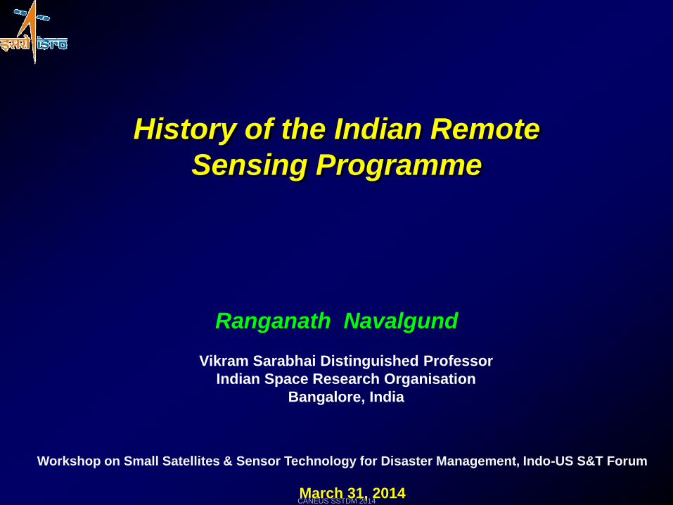
History of the Indian Remote
Sensing Programme
Ranganath Navalgund
Vikram Sarabhai Distinguished Professor
Indian Space Research Organisation
Bangalore, India
March 31, 2014
Workshop on Small Satellites & Sensor Technology for Disaster Management, Indo-US S&T Forum
CANEUS SSTDM 2014
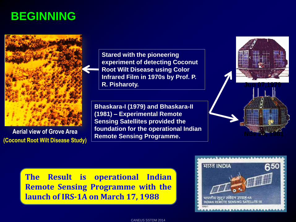
BEGINNING
Stared with the pioneering
experiment of detecting Coconut
Root Wilt Disease using Color
Infrared Film in 1970s by Prof. P.
R. Pisharoty.
Aerial view of Grove Area
(Coconut Root Wilt Disease Study)
Bhaskara-I (1979) and Bhaskara-II
(1981) – Experimental Remote
Sensing Satellites provided the
foundation for the operational Indian
Remote Sensing Programme. Nov 20, 1981
Jun 07,1979
The Result is operational IndianRemote Sensing Programme with thelaunch of IRS-1A on March 17, 1988
CANEUS SSTDM 2014
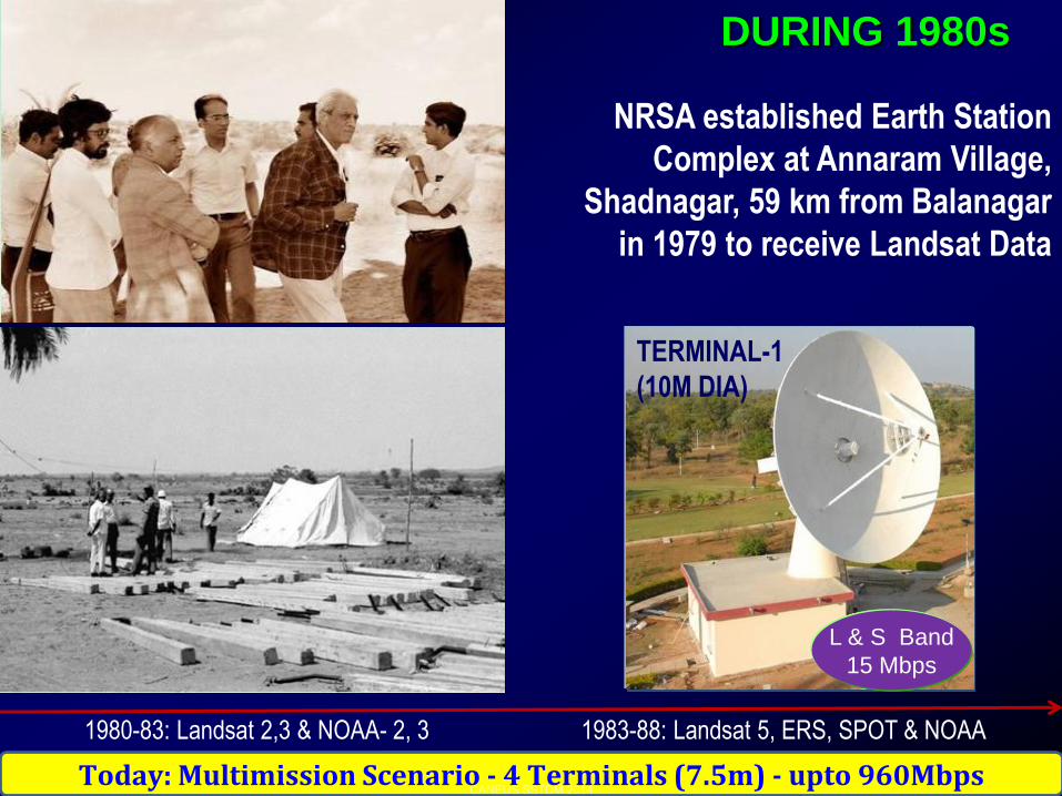
TERMINAL-1
(10M DIA)
NRSA established Earth Station
Complex at Annaram Village,
Shadnagar, 59 km from Balanagar
in 1979 to receive Landsat Data
DURING 1980s
L & S Band
15 Mbps
1980-83: Landsat 2,3 & NOAA- 2, 3 1983-88: Landsat 5, ERS, SPOT & NOAA
Today: Multimission Scenario - 4 Terminals (7.5m) - upto 960MbpsCANEUS SSTDM 2014
……..towards enabling solutions
(High Spatial Resolution
& Stereo Capability)
(Multi resolution, Frequent observations, Better radiometry)
(High Repetivity/Revisit,
High Spatial Resolution)
IRS-1A/1B/P2(1988,1991,1994) LISS-I: 72.5m, 4XS LISS-II: 36.5m, 4XS
IRS-1C/1D (1995,1997) LISS-3: 23/70 m, Steerable PAN: 5.8 m, WiFS: 188 m
BHASKARA 1 /2 (1979,1981) TV Camera, Microwave
Radiometer170-180 K
> 265 K
Hot
170-180 K
> 265 K
Hot
Resourcesat-1/2 (2003, 2011) LISS-3: 23 m, 4 XS, LISS-4: 5.8 m, 3-XS, AWiFS: 56 m, 4-XS
TES, Cartosat-1, 2/2A/2B (1999, 2005, 2007, 2008, 2010) PAN : 2.5 m, 1m Fore
+26o Aft: -5o
IMS-1 (2008) HySI Sensor (64 bands, 506 m) TWSAT-MX (4 bands, 37 m)
Land Applications
RISAT-1 (2012) C Band SAR (5.35 GHz)
(HyperspectralCapability)
(Microwave Capability)
EVOLUTION OF
INDIAN EO SYSTEMS
CANEUS SSTDM 2014
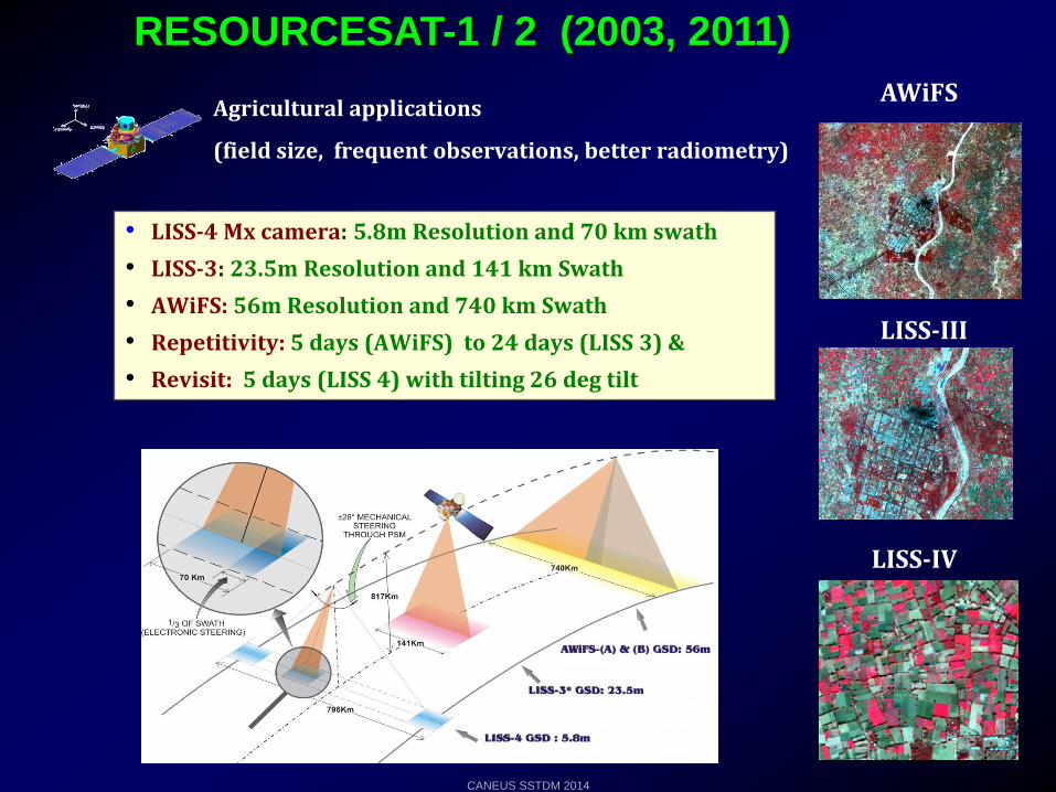
RESOURCESAT-1 / 2 (2003, 2011)
Agricultural applications
(field size, frequent observations, better radiometry)
AWiFS
LISS-III
LISS-IV
• LISS-4 Mx camera: 5.8m Resolution and 70 km swath
• LISS-3: 23.5m Resolution and 141 km Swath
• AWiFS: 56m Resolution and 740 km Swath
• Repetitivity: 5 days (AWiFS) to 24 days (LISS 3) &
• Revisit: 5 days (LISS 4) with tilting 26 deg tilt
CANEUS SSTDM 2014
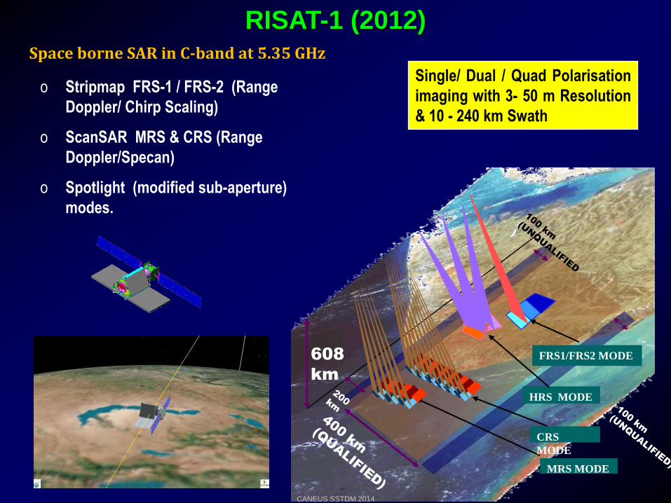
RISAT-1 (2012)
o Stripmap FRS-1 / FRS-2 (Range
Doppler/ Chirp Scaling)
o ScanSAR MRS & CRS (Range
Doppler/Specan)
o Spotlight (modified sub-aperture)
modes.
Space borne SAR in C-band at 5.35 GHz
Single/ Dual / Quad Polarisation
imaging with 3- 50 m Resolution
& 10 - 240 km Swath
FRS1/FRS2 MODE
HRS MODE
608
km
CRS
MODE
MRS MODE
CANEUS SSTDM 2014
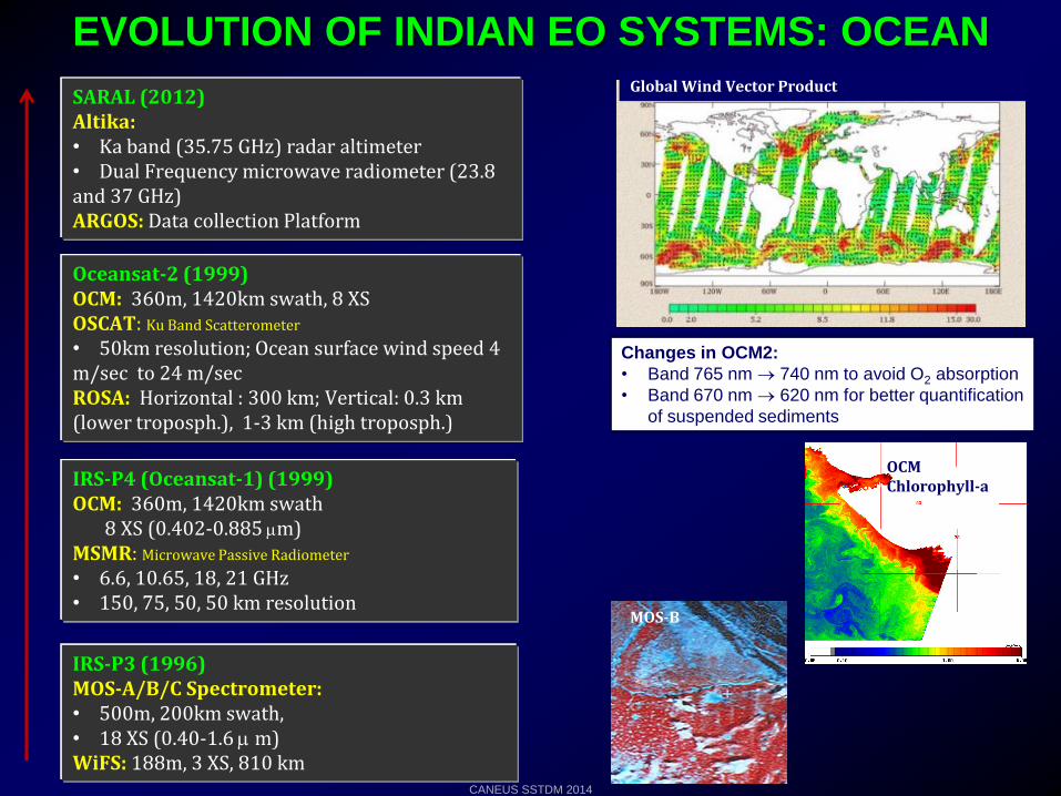
EVOLUTION OF INDIAN EO SYSTEMS: OCEAN
IRS-P3 (1996)MOS-A/B/C Spectrometer: • 500m, 200km swath, • 18 XS (0.40-1.6 m)WiFS: 188m, 3 XS, 810 km
IRS-P4 (Oceansat-1) (1999)OCM: 360m, 1420km swath
8 XS (0.402-0.885 m)MSMR: Microwave Passive Radiometer
• 6.6, 10.65, 18, 21 GHz • 150, 75, 50, 50 km resolution
Oceansat-2 (1999)OCM: 360m, 1420km swath, 8 XS OSCAT: Ku Band Scatterometer
• 50km resolution; Ocean surface wind speed 4 m/sec to 24 m/secROSA: Horizontal : 300 km; Vertical: 0.3 km (lower troposph.), 1-3 km (high troposph.)
SARAL (2012)Altika: • Ka band (35.75 GHz) radar altimeter• Dual Frequency microwave radiometer (23.8 and 37 GHz)ARGOS: Data collection Platform
OCM Chlorophyll-a
Changes in OCM2:
• Band 765 nm 740 nm to avoid O2 absorption
• Band 670 nm 620 nm for better quantification
of suspended sediments
MOS-B
Global Wind Vector Product
CANEUS SSTDM 2014
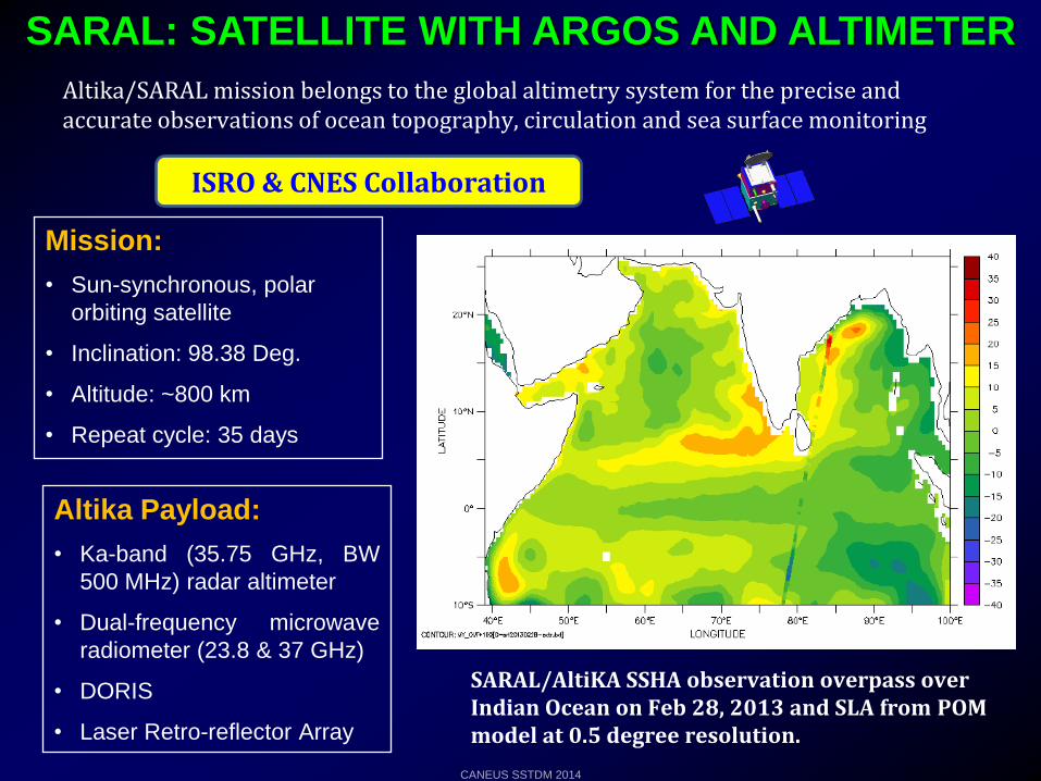
Altika/SARAL mission belongs to the global altimetry system for the precise and accurate observations of ocean topography, circulation and sea surface monitoring
SARAL: SATELLITE WITH ARGOS AND ALTIMETER
Mission:
• Sun-synchronous, polar
orbiting satellite
• Inclination: 98.38 Deg.
• Altitude: ~800 km
• Repeat cycle: 35 days
Altika Payload:
• Ka-band (35.75 GHz, BW
500 MHz) radar altimeter
• Dual-frequency microwave
radiometer (23.8 & 37 GHz)
• DORIS
• Laser Retro-reflector Array
ISRO & CNES Collaboration
SARAL/AltiKA SSHA observation overpass over Indian Ocean on Feb 28, 2013 and SLA from POMmodel at 0.5 degree resolution.
CANEUS SSTDM 2014
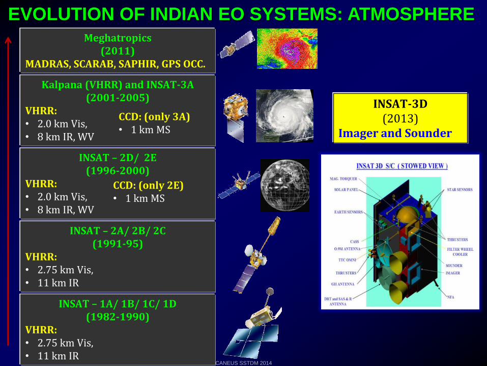
EVOLUTION OF INDIAN EO SYSTEMS: ATMOSPHERE
INSAT – 1A/ 1B/ 1C/ 1D (1982-1990)
VHRR: • 2.75 km Vis, • 11 km IR
INSAT – 2A/ 2B/ 2C (1991-95)
VHRR: • 2.75 km Vis, • 11 km IR
INSAT – 2D/ 2E (1996-2000)
VHRR: • 2.0 km Vis, • 8 km IR, WV
Kalpana (VHRR) and INSAT-3A(2001-2005)
VHRR: • 2.0 km Vis, • 8 km IR, WV
CCD: (only 3A)• 1 km MS
CCD: (only 2E)• 1 km MS
Meghatropics(2011)
MADRAS, SCARAB, SAPHIR, GPS OCC.
INSAT-3D(2013)
Imager and Sounder
CANEUS SSTDM 2014
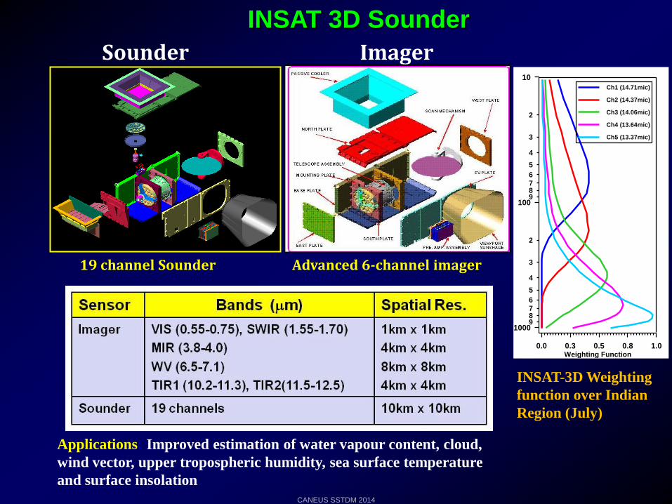
INSAT 3D Sounder
Sounder Imager
EXPLODED VIEW OF SOUNDER E.O.MODULE
SMG/SEDA/SAC
0.5 1.0 1.5 2.0Weighting Function
2
3
4
5
6789
2
3
4
5
6789
10
100
1000
Ch6 (12.66mic)
Ch7 (12.02mic)
Ch8 (11.03mic)
Ch9 (9.71mic)
Ch10 (7.43mic)
Ch11 (7.02mic)
Ch12 (6.51mic)
INSAT-3D Weighting Function over Indian Region (July)
0.0 0.3 0.5 0.8 1.0Weighting Function
2
3
4
5
6789
2
3
4
5
6789
10
100
1000
Ch1 (14.71mic)
Ch2 (14.37mic)
Ch3 (14.06mic)
Ch4 (13.64mic)
Ch5 (13.37mic)
0.00 0.25 0.50 0.75Weighting Function
2
3
4
5
6789
2
3
4
5
6789
10
100
1000
Ch13 (4.57mic)
Ch14 (4.52mic)
Ch15 (4.45mic)
Ch16 (4.13mic)
Ch17 (3.98mic)
Ch18 (3.74mic)
INSAT-3D Weighting
function over Indian
Region (July)
19 channel Sounder Advanced 6-channel imager
Applications: Improved estimation of water vapour content, cloud,
wind vector, upper tropospheric humidity, sea surface temperature
and surface insolation
CANEUS SSTDM 2014
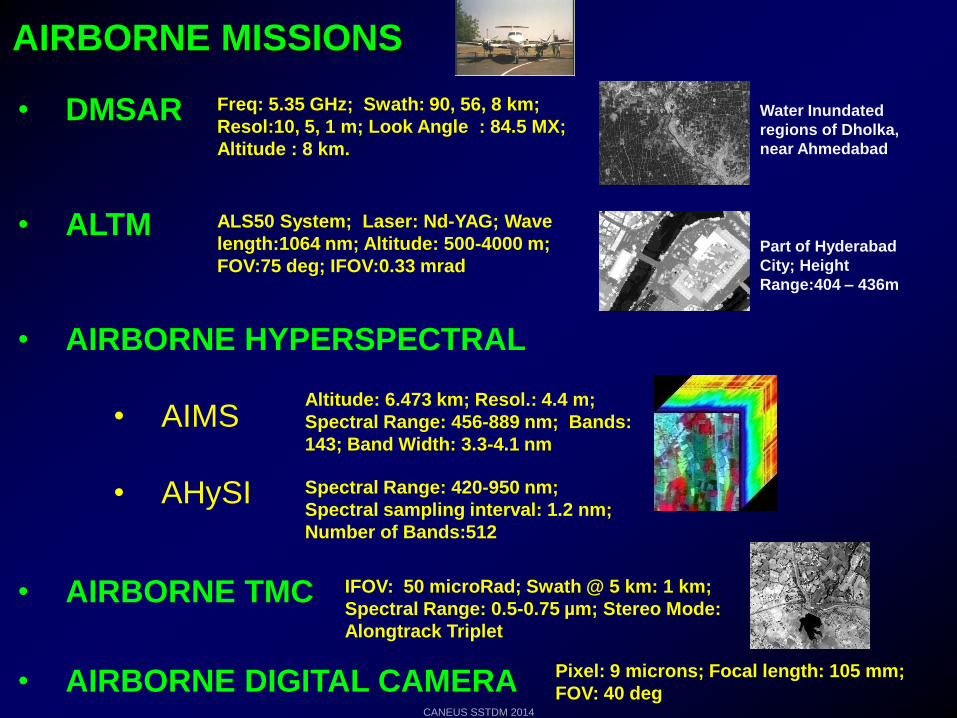
AIRBORNE MISSIONS
• DMSAR
• ALTM
• AIRBORNE HYPERSPECTRAL
• AIMS
• AHySI
• AIRBORNE TMC
• AIRBORNE DIGITAL CAMERA
Freq: 5.35 GHz; Swath: 90, 56, 8 km;
Resol:10, 5, 1 m; Look Angle : 84.5 MX;
Altitude : 8 km.
Water Inundated
regions of Dholka,
near Ahmedabad
Part of Hyderabad
City; Height
Range:404 – 436m
ALS50 System; Laser: Nd-YAG; Wave
length:1064 nm; Altitude: 500-4000 m;
FOV:75 deg; IFOV:0.33 mrad
Pixel: 9 microns; Focal length: 105 mm;
FOV: 40 deg
Altitude: 6.473 km; Resol.: 4.4 m;
Spectral Range: 456-889 nm; Bands:
143; Band Width: 3.3-4.1 nm
Spectral Range: 420-950 nm;
Spectral sampling interval: 1.2 nm;
Number of Bands:512
IFOV: 50 microRad; Swath @ 5 km: 1 km;
Spectral Range: 0.5-0.75 µm; Stereo Mode:
Alongtrack Triplet
CANEUS SSTDM 2014
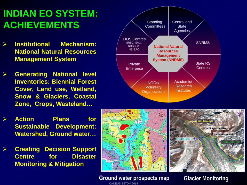
Institutional Mechanism:
National Natural Resources
Management System
Generating National level
Inventories: Biennial Forest
Cover, Land use, Wetland,
Snow & Glaciers, Coastal
Zone, Crops, Wasteland…
Action Plans for
Sustainable Development:
Watershed, Ground water…
Creating Decision Support
Centre for Disaster
Monitoring & Mitigation
INDIAN EO SYSTEM:
ACHIEVEMENTS
Glacier MonitoringGround water prospects map
Standing Committees
Central and State
Agencies
SNRMS
State RS Centres
Academic/Research Institutes
NGOs/Voluntary
Organizations
Private Enterprise
DOS Centres NRSC, SAC,
RRSSCs ,
NE-SACNational Natural
Resources Management
System (NNRMS)
Standing Committees
Central and State
Agencies
SNRMS
State RS Centres
Academic/Research Institutes
NGOs/Voluntary
Organizations
Private Enterprise
DOS Centres NRSC, SAC,
RRSSCs ,
NE-SACNational Natural
Resources Management
System (NNRMS)
CANEUS SSTDM 2014
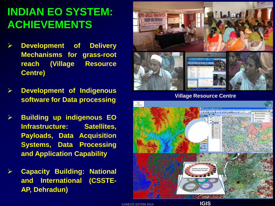
Development of Delivery
Mechanisms for grass-root
reach (Village Resource
Centre)
Development of Indigenous
software for Data processing
Building up indigenous EO
Infrastructure: Satellites,
Payloads, Data Acquisition
Systems, Data Processing
and Application Capability
Capacity Building: National
and International (CSSTE-
AP, Dehradun)
Village Resource Centre
INDIAN EO SYSTEM:
ACHIEVEMENTS
IGISCANEUS SSTDM 2014
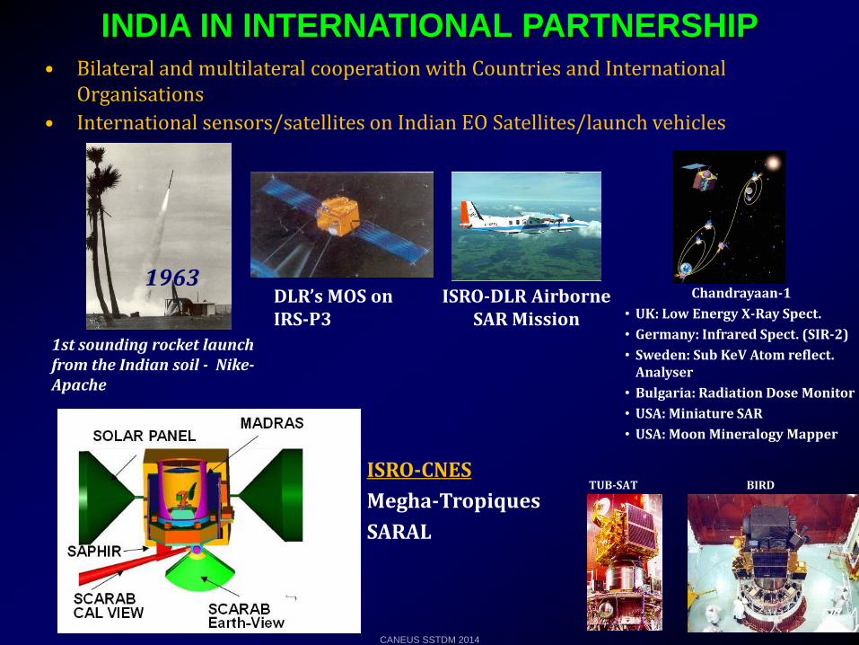
INDIA IN INTERNATIONAL PARTNERSHIP• Bilateral and multilateral cooperation with Countries and International
Organisations
• International sensors/satellites on Indian EO Satellites/launch vehicles
ISRO-DLR Airborne SAR Mission
TUB-SAT BIRDISRO-CNES
Megha-Tropiques
SARAL
1st sounding rocket launch from the Indian soil - Nike-Apache
1963Chandrayaan-1
• UK: Low Energy X-Ray Spect.
• Germany: Infrared Spect. (SIR-2)
• Sweden: Sub KeV Atom reflect. Analyser
• Bulgaria: Radiation Dose Monitor
• USA: Miniature SAR
• USA: Moon Mineralogy Mapper
DLR’s MOS on IRS-P3
CANEUS SSTDM 2014
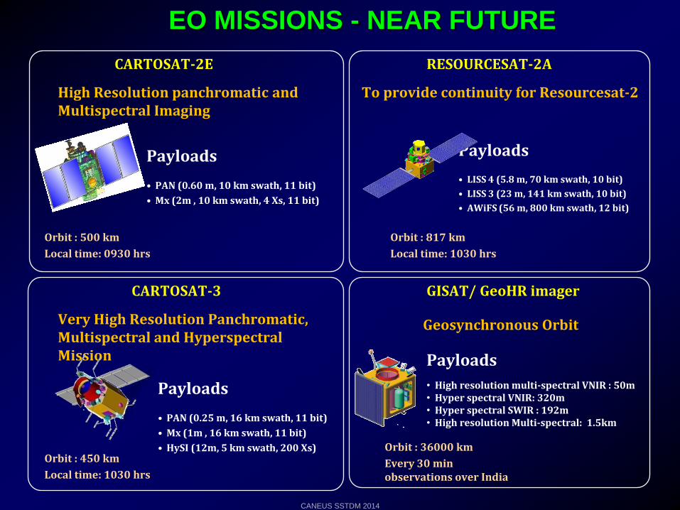
RESOURCESAT-2A
Payloads
• LISS 4 (5.8 m, 70 km swath, 10 bit)
• LISS 3 (23 m, 141 km swath, 10 bit)
• AWiFS (56 m, 800 km swath, 12 bit)
To provide continuity for Resourcesat-2
GISAT/ GeoHR imager
Geosynchronous Orbit
Payloads
• High resolution multi-spectral VNIR : 50m• Hyper spectral VNIR: 320m • Hyper spectral SWIR : 192m• High resolution Multi-spectral: 1.5km
CARTOSAT-2E
Payloads
• PAN (0.60 m, 10 km swath, 11 bit)
• Mx (2m , 10 km swath, 4 Xs, 11 bit)
High Resolution panchromatic and Multispectral Imaging
CARTOSAT-3
Very High Resolution Panchromatic, Multispectral and HyperspectralMission
Orbit : 500 km
Local time: 0930 hrs
Orbit : 817 km
Local time: 1030 hrs
Orbit : 450 km
Local time: 1030 hrs
Payloads
• PAN (0.25 m, 16 km swath, 11 bit)
• Mx (1m , 16 km swath, 11 bit)
• HySI (12m, 5 km swath, 200 Xs) Orbit : 36000 km
Every 30 min observations over India
EO MISSIONS - NEAR FUTURE
CANEUS SSTDM 2014

CANEUS SSTDM 2014
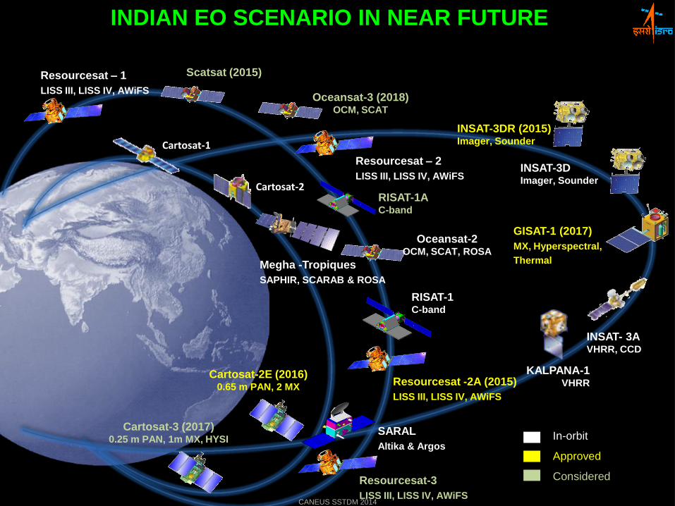
INDIAN EO SCENARIO IN NEAR FUTURE
Cartosat-2E (2016)0.65 m PAN, 2 MX
Megha -Tropiques
SAPHIR, SCARAB & ROSA
Resourcesat – 2
LISS III, LISS IV, AWiFS
Oceansat-2OCM, SCAT, ROSA
RISAT-1C-band
Oceansat-3 (2018)OCM, SCAT
SARAL
Altika & Argos
Resourcesat -2A (2015)
LISS III, LISS IV, AWiFS
INSAT-3D Imager, Sounder
GISAT-1 (2017)
MX, Hyperspectral,
Thermal
INSAT-3DR (2015) Imager, Sounder
Cartosat-3 (2017)0.25 m PAN, 1m MX, HYSI
Scatsat (2015)
RISAT-1AC-band
Resourcesat-3
LISS III, LISS IV, AWiFS
Cartosat-1
Cartosat-2
In-orbit
Approved
Considered
Resourcesat – 1
LISS III, LISS IV, AWiFS
INSAT- 3A VHRR, CCD
KALPANA-1VHRR
CANEUS SSTDM 2014
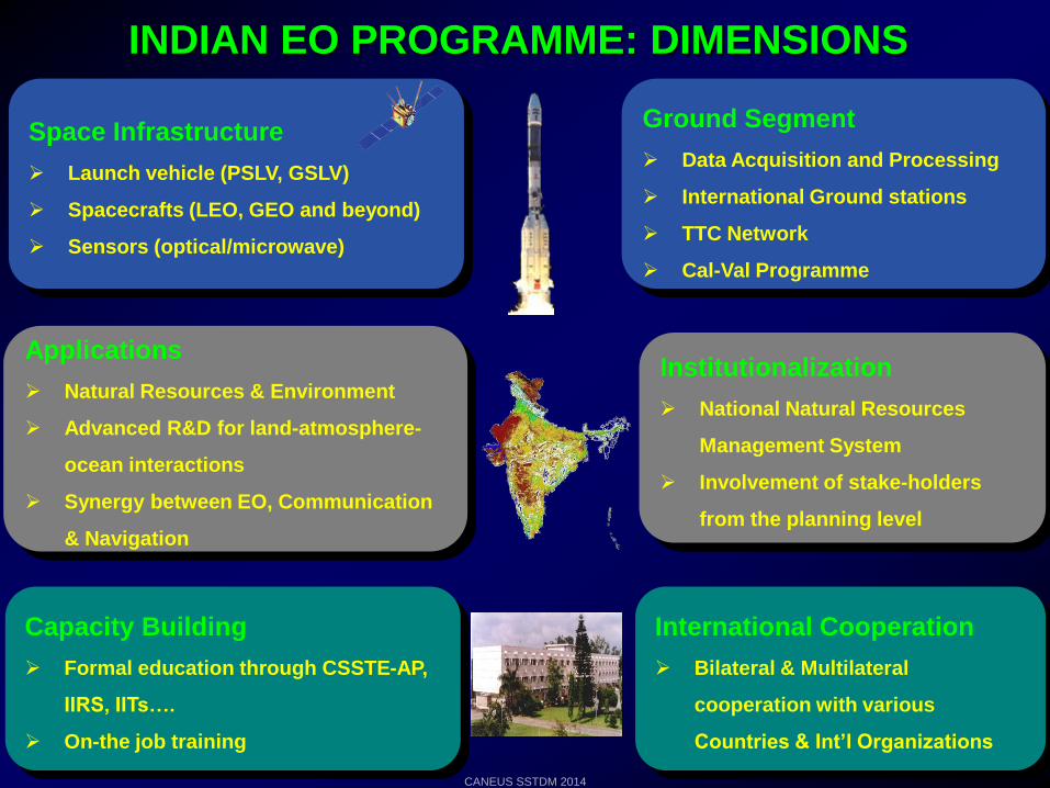
INDIAN EO PROGRAMME: DIMENSIONS
Space Infrastructure
Launch vehicle (PSLV, GSLV)
Spacecrafts (LEO, GEO and beyond)
Sensors (optical/microwave)
Ground Segment
Data Acquisition and Processing
International Ground stations
TTC Network
Cal-Val Programme
Capacity Building
Formal education through CSSTE-AP,
IIRS, IITs….
On-the job training
Institutionalization
National Natural Resources
Management System
Involvement of stake-holders
from the planning level
Applications
Natural Resources & Environment
Advanced R&D for land-atmosphere-
ocean interactions
Synergy between EO, Communication
& Navigation
International Cooperation
Bilateral & Multilateral
cooperation with various
Countries & Int’l Organizations
CANEUS SSTDM 2014
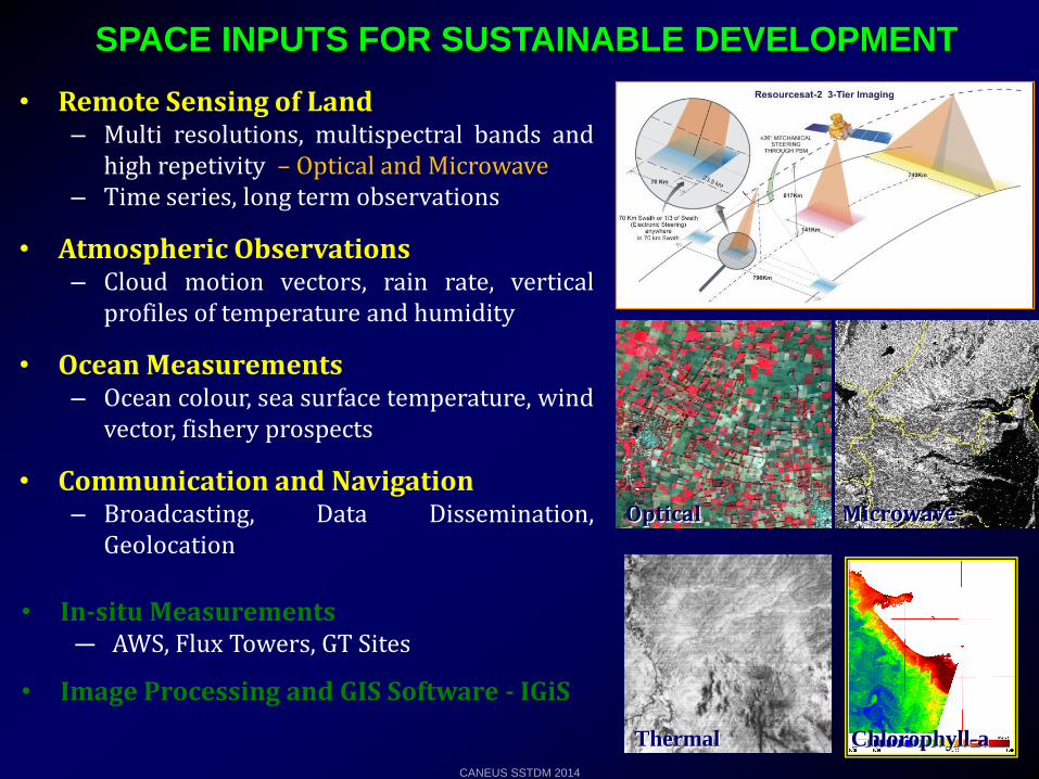
• Remote Sensing of Land– Multi resolutions, multispectral bands and
high repetivity – Optical and Microwave– Time series, long term observations
• Atmospheric Observations– Cloud motion vectors, rain rate, vertical
profiles of temperature and humidity
• Ocean Measurements– Ocean colour, sea surface temperature, wind
vector, fishery prospects
• Communication and Navigation– Broadcasting, Data Dissemination,
Geolocation
SPACE INPUTS FOR SUSTAINABLE DEVELOPMENT
Microwave
Thermal
Optical
• In-situ Measurements— AWS, Flux Towers, GT Sites
• Image Processing and GIS Software - IGiS
Chlorophyll-a
CANEUS SSTDM 2014
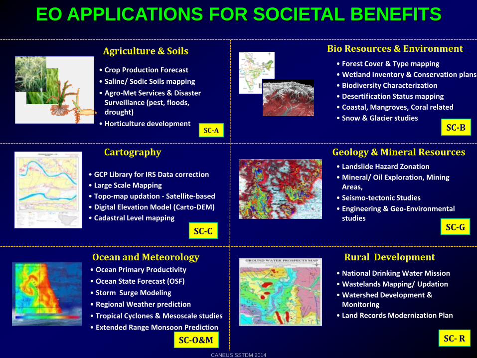
EO APPLICATIONS FOR SOCIETAL BENEFITS
Rural Development
• National Drinking Water Mission
• Wastelands Mapping/ Updation
• Watershed Development & Monitoring
• Land Records Modernization Plan
• Crop Production Forecast
• Saline/ Sodic Soils mapping
• Agro-Met Services & Disaster Surveillance (pest, floods, drought)
• Horticulture development
Agriculture & Soils • Forest Cover & Type mapping
• Wetland Inventory & Conservation plans
• Biodiversity Characterization
• Desertification Status mapping
• Coastal, Mangroves, Coral related
• Snow & Glacier studies
Bio Resources & Environment
Geology & Mineral Resources
• Landslide Hazard Zonation
• Mineral/ Oil Exploration, Mining Areas,
• Seismo-tectonic Studies
• Engineering & Geo-Environmental studies
SC-A SC-B
SC-G
SC- R
• GCP Library for IRS Data correction
• Large Scale Mapping
• Topo-map updation - Satellite-based
• Digital Elevation Model (Carto-DEM)
• Cadastral Level mapping
Cartography
SC-C
• Ocean Primary Productivity
• Ocean State Forecast (OSF)
• Storm Surge Modeling
• Regional Weather prediction
• Tropical Cyclones & Mesoscale studies
• Extended Range Monsoon Prediction
Ocean and Meteorology
SC-O&M
CANEUS SSTDM 2014
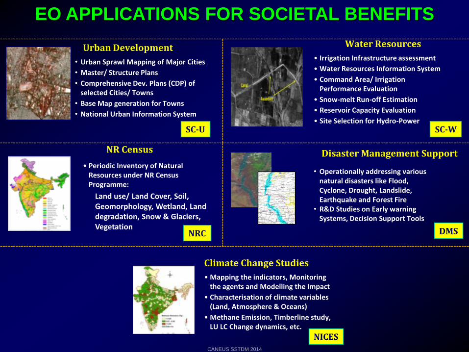
EO APPLICATIONS FOR SOCIETAL BENEFITS
NICES
Disaster Management Support
• Operationally addressing various natural disasters like Flood, Cyclone, Drought, Landslide, Earthquake and Forest Fire
• R&D Studies on Early warning Systems, Decision Support Tools
NR Census
• Periodic Inventory of Natural Resources under NR Census Programme:
Land use/ Land Cover, Soil, Geomorphology, Wetland, Land degradation, Snow & Glaciers, Vegetation
DMSNRC
Urban Development
• Urban Sprawl Mapping of Major Cities
• Master/ Structure Plans
• Comprehensive Dev. Plans (CDP) of selected Cities/ Towns
• Base Map generation for Towns
• National Urban Information System
SC-U
• Irrigation Infrastructure assessment
• Water Resources Information System
• Command Area/ Irrigation Performance Evaluation
• Snow-melt Run-off Estimation
• Reservoir Capacity Evaluation
• Site Selection for Hydro-Power
Water Resources
SC-W
Climate Change Studies
• Mapping the indicators, Monitoring the agents and Modelling the Impact
• Characterisation of climate variables (Land, Atmosphere & Oceans)
• Methane Emission, Timberline study, LU LC Change dynamics, etc.
CANEUS SSTDM 2014
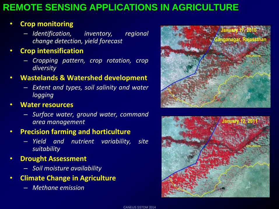
REMOTE SENSING APPLICATIONS IN AGRICULTURE
• Crop monitoring– Identification, inventory, regional
change detection, yield forecast
• Crop intensification– Cropping pattern, crop rotation, crop
diversity
• Wastelands & Watershed development– Extent and types, soil salinity and water
logging
• Water resources– Surface water, ground water, command
area management
• Precision farming and horticulture– Yield and nutrient variability, site
suitability
• Drought Assessment– Soil moisture availability
• Climate Change in Agriculture– Methane emission
January 12, 2011
January 17, 2010
Ganganagar, Rajassthan
CANEUS SSTDM 2014
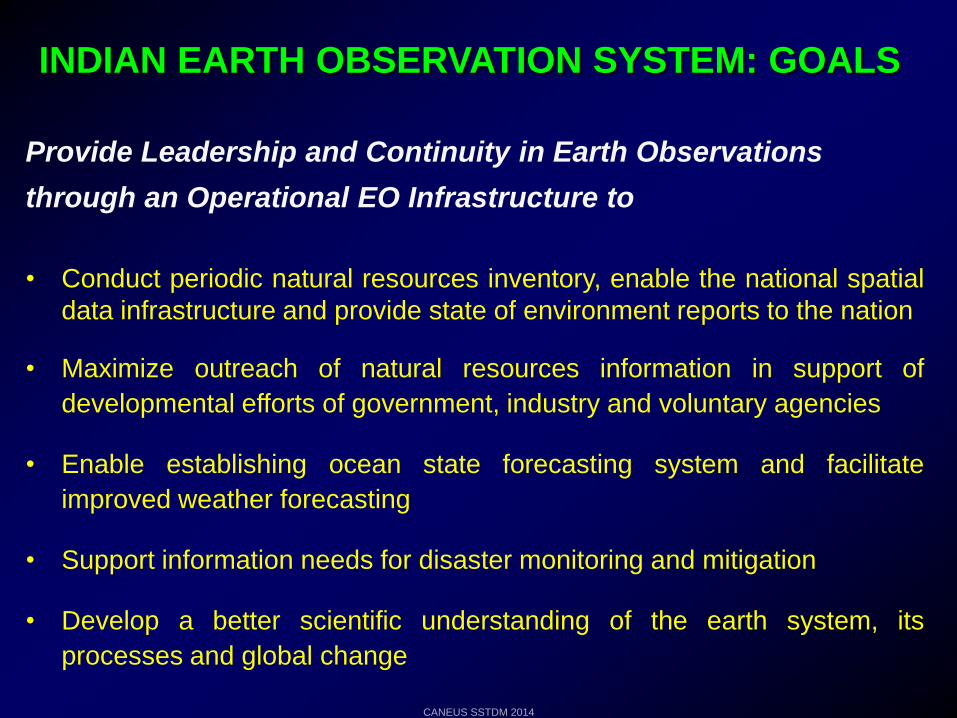
INDIAN EARTH OBSERVATION SYSTEM: GOALS
• Conduct periodic natural resources inventory, enable the national spatial
data infrastructure and provide state of environment reports to the nation
• Maximize outreach of natural resources information in support of
developmental efforts of government, industry and voluntary agencies
• Enable establishing ocean state forecasting system and facilitate
improved weather forecasting
• Support information needs for disaster monitoring and mitigation
• Develop a better scientific understanding of the earth system, its
processes and global change
Provide Leadership and Continuity in Earth Observations
through an Operational EO Infrastructure to
CANEUS SSTDM 2014
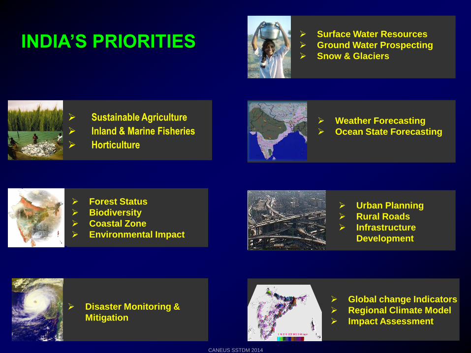
INDIA’S PRIORITIES
Sustainable Agriculture
Inland & Marine Fisheries
Horticulture
Forest Status
Biodiversity
Coastal Zone
Environmental Impact
Disaster Monitoring &
Mitigation
Urban Planning
Rural Roads
Infrastructure
Development
Surface Water Resources
Ground Water Prospecting
Snow & Glaciers
Weather Forecasting
Ocean State Forecasting
Global change Indicators
Regional Climate Model
Impact Assessment
CANEUS SSTDM 2014
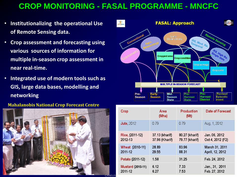
CROP MONITORING - FASAL PROGRAMME - MNCFC
• Institutionalizing the operational Use
of Remote Sensing data.
• Crop assessment and forecasting using
various sources of information for
multiple in-season crop assessment in
near real-time.
• Integrated use of modern tools such as
GIS, large data bases, modelling and
networking
Mahalanobis National Crop Forecast Centre
CANEUS SSTDM 2014
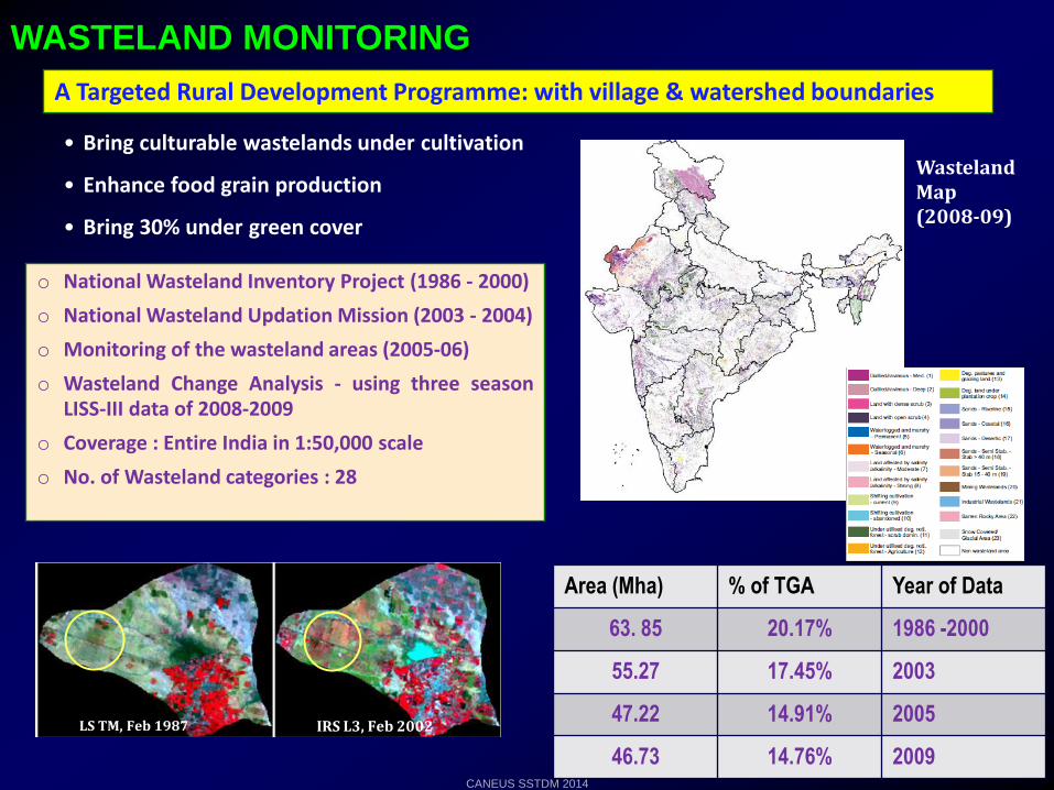
WASTELAND MONITORING
A Targeted Rural Development Programme: with village & watershed boundaries
o National Wasteland Inventory Project (1986 - 2000)
o National Wasteland Updation Mission (2003 - 2004)
o Monitoring of the wasteland areas (2005-06)
o Wasteland Change Analysis - using three seasonLISS-III data of 2008-2009
o Coverage : Entire India in 1:50,000 scale
o No. of Wasteland categories : 28
• Bring culturable wastelands under cultivation
• Enhance food grain production
• Bring 30% under green cover
Area (Mha) % of TGA Year of Data
63. 85 20.17% 1986 -2000
55.27 17.45% 2003
47.22 14.91% 2005
46.73 14.76% 2009
LS TM, Feb 1987 IRS L3, Feb 2002
Wasteland Map (2008-09)
CANEUS SSTDM 2014

IDENTIFICATION OF PROBLEMATIC SOILS
1 Strongly Saline- Sodic Soils
2 Moderately saline –Sodic Soils
3 Slightly saline – Sodic soils
1
1
2
2
3
3
3
1975
1999
• Problematic soils have been mapped.
• Monitoring of the reclamation of the salt affected soils has also been done using muti-date satellite imagery
• Waterlogged areas – Mapped and monitored
1975 – 46,029 ha 1999 – 28,749 ha
1975 1999
Salt- Affected Soils in Part of Sharda Sahayak Command Area (Indo-Gangetic Plains), Jaunpur (UP)
CANEUS SSTDM 2014
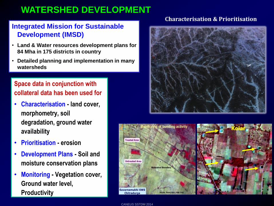
WATERSHED DEVELOPMENT
Integrated Mission for Sustainable
Development (IMSD)
• Land & Water resources development plans for
84 Mha in 175 districts in country
• Detailed planning and implementation in many
watersheds
Space data in conjunction with
collateral data has been used for
• Characterisation - land cover,
morphometry, soil
degradation, ground water
availability
• Prioritisation - erosion
• Development Plans - Soil and
moisture conservation plans
• Monitoring - Vegetation cover,
Ground water level,
Productivity
Characterisation & Prioritisation
Kolar
CANEUS SSTDM 2014
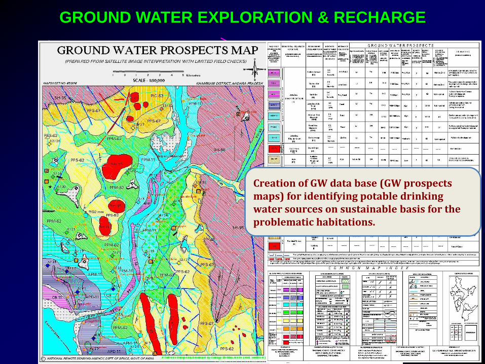
GROUND WATER EXPLORATION & RECHARGE
Creation of GW data base (GW prospects maps) for identifying potable drinking water sources on sustainable basis for the problematic habitations.
CANEUS SSTDM 2014
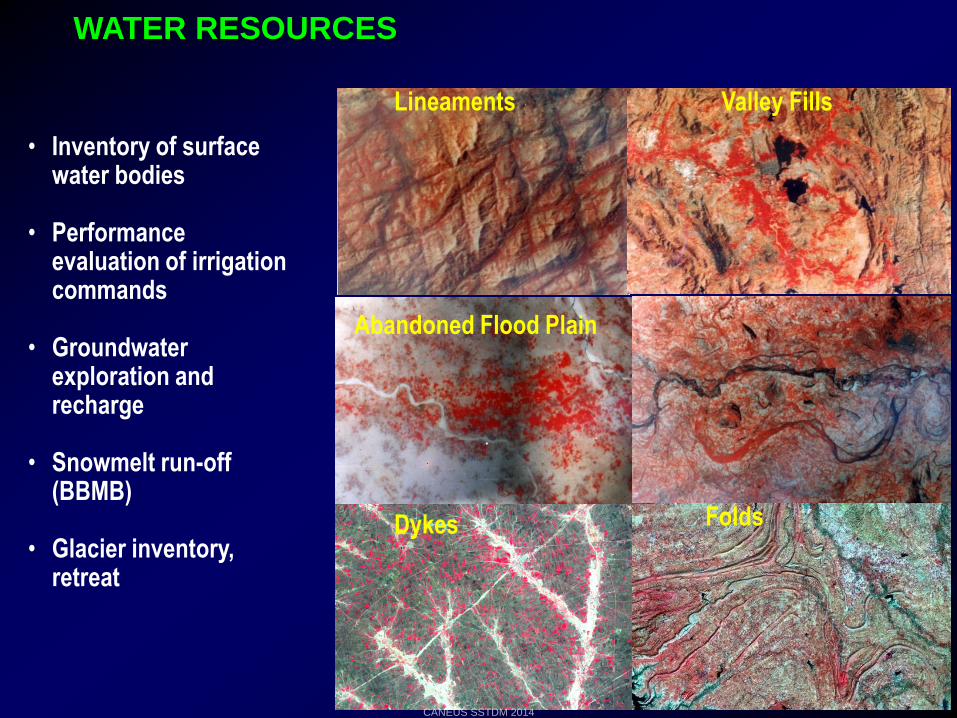
Lineaments Valley Fills
Abandoned Flood Plain Palaeochannels
Dykes Folds
WATER RESOURCES
• Inventory of surface water bodies
• Performance evaluation of irrigation commands
• Groundwater exploration and recharge
• Snowmelt run-off (BBMB)
• Glacier inventory, retreat
CANEUS SSTDM 2014
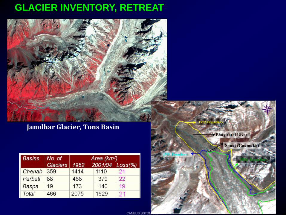
GLACIER INVENTORY, RETREAT
Jamdhar Glacier, Tons Basin
CANEUS SSTDM 2014
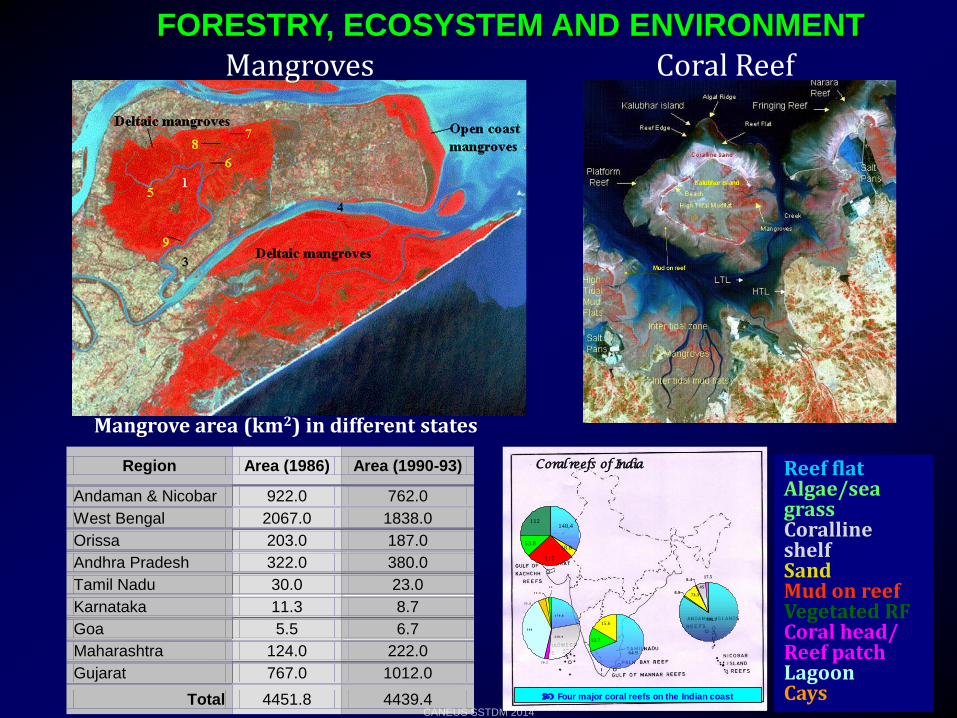
FORESTRY, ECOSYSTEM AND ENVIRONMENT
Mangroves Coral Reef
Four major coral reefs on the Indian coast
795.7
8.973.3
8.4
45
17.5
148.4
18.8
117
53.8
112
64.9
13.7
15.6
3 0 9
1 2
2 3 0 . 9
1 7 9 . 8
1 2 . 3
2 0 . 2
3 5 . 4
Lakshadweep
Reef flatAlgae/seagrassCoralline shelf
SandMud on reefVegetated RFCoral head/Reef patch
LagoonCays
Coral reefs of India Reef flatAlgae/sea grassCoralline shelfSandMud on reefVegetated RFCoral head/ Reef patchLagoonCays
Region Area (1986) Area (1990-93)
Andaman & Nicobar 922.0 762.0
West Bengal 2067.0 1838.0
Orissa 203.0 187.0
Andhra Pradesh 322.0 380.0
Tamil Nadu 30.0 23.0
Karnataka 11.3 8.7
Goa 5.5 6.7
Maharashtra 124.0 222.0
Gujarat 767.0 1012.0
Total 4451.8 4439.4
Mangrove area (km2) in different states
CANEUS SSTDM 2014
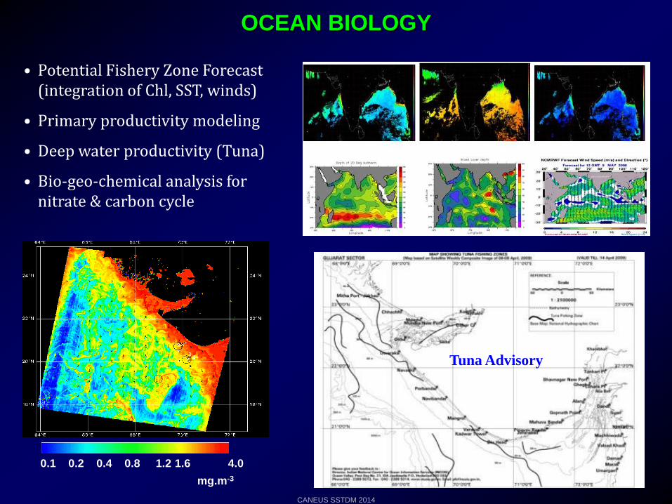
• Potential Fishery Zone Forecast (integration of Chl, SST, winds)
• Primary productivity modeling
• Deep water productivity (Tuna)
• Bio-geo-chemical analysis for nitrate & carbon cycle
OCEAN BIOLOGY
0.1 0.2 0.4 0.8 1.2 1.6 4.0
mg.m-3
Tuna Advisory
CANEUS SSTDM 2014
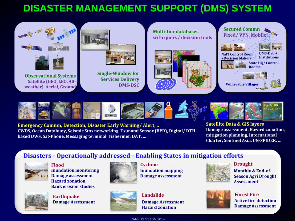
Observational SystemsSatellite (GEO, LEO, All-
weather), Aerial, Ground
Satellite Data & GIS layersDamage assessment, Hazard zonation, mitigation planning, International Charter, Sentinel Asia, UN-SPIDER, …
Emergency Commn, Detection, Disaster Early Warning/ Alert, .. CWDS, Ocean Databuoy, Seismic Stns networking, Tsunami Sensor (BPR), Digital/ DTH based DWS, Sat-Phone, Messaging terminal, Fishermen DAT, …
Single-Window for Services Delivery
DMS-DSC
Multi-tier databases with query/ decision tools
Secured CommnFixed/ VPN, Mobile ..
Nat’l Control Room +Decision Makers
DMS-DSC + Institutions
Vulnerable Villages
State HQ/ Control Rooms
Inundation monitoringDamage assessmentHazard zonationBank erosion studies
FloodMonthly & End-of-Season Agri Drought Assessment
Drought
Inundation mapping Damage assessment
Damage AssessmentHazard zonation
Damage AssessmentEarthquake
Active fire detectionDamage assessment
Forest Fire
Cyclone
Landslide
Disasters - Operationally addressed - Enabling States in mitigation efforts
Nov 20, 07
Post-SIDR
DISASTER MANAGEMENT SUPPORT (DMS) SYSTEM
CANEUS SSTDM 2014
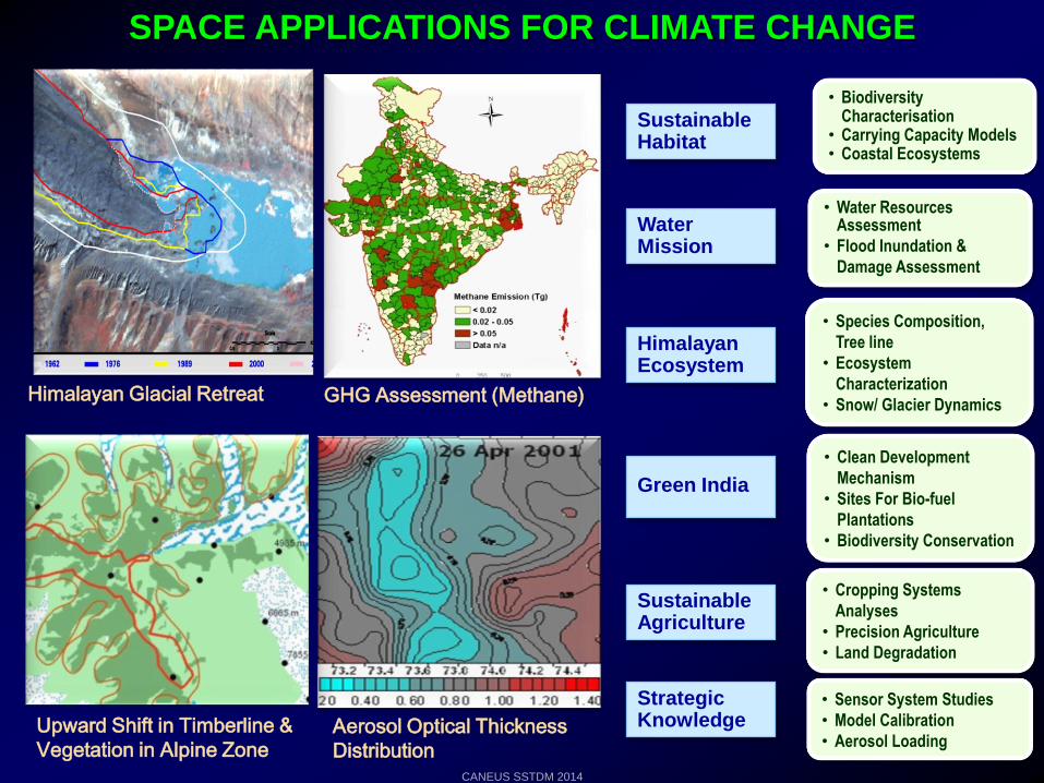
GHG Assessment (Methane)
Aerosol Optical Thickness
Distribution
Upward Shift in Timberline &
Vegetation in Alpine Zone
Himalayan Glacial Retreat
SPACE APPLICATIONS FOR CLIMATE CHANGE
Water Mission
Sustainable Habitat
Sustainable Agriculture
Strategic Knowledge
Himalayan Ecosystem
Green India
• Biodiversity Characterisation
• Carrying Capacity Models• Coastal Ecosystems
• Water Resources Assessment
• Flood Inundation &
Damage Assessment
• Species Composition,
Tree line
• Ecosystem
Characterization
• Snow/ Glacier Dynamics
• Clean Development
Mechanism
• Sites For Bio-fuel
Plantations
• Biodiversity Conservation
• Cropping Systems
Analyses
• Precision Agriculture
• Land Degradation
• Sensor System Studies
• Model Calibration
• Aerosol Loading
CANEUS SSTDM 2014


![Remote Sensing of Environment - NASA1].pdf · Variability of outdoor fine particulate (PM 2.5) concentration in the Indian Subcontinent: A remote sensing approach Sagnik Dey a,⁎,](https://img.pdfslide.us/doc/110x75/5b7473a07f8b9a0c188bc755/remote-sensing-of-environment-nasa-1pdf-variability-of-outdoor-ne-particulate.jpg)