Embed Size (px)
Citation preview
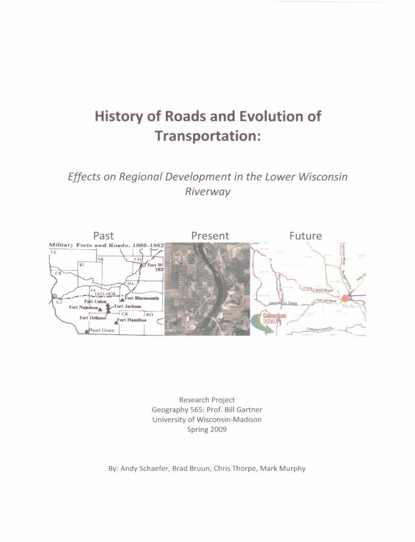
History of Roads and Evolution of Transportation:
Effects on Regional Development in the Lower Wisconsin
Riverway
Past Present Future l\'Iilitary Forts and KoadlJ. 1805-1862
\E .'
Rf
Research Project Geography 565: Prof. Bill Gartner University of Wisconsin-Madison
Spring 2009
By: Andy Schaefer, Brad Bruun, Chris Thorpe, Mark Murphy

Literature Review
Part 1- Road and Regional Development Theory, First Roads
Research on my topic has been qualitative and theory based. Its primary emphasis is to
examine how past, present and future road building acts as a catalyst or reaction to population
growth and economic development in the Lower Wisconsin Riverway. Also being explored is
the increased reliance on the automobile from the early part of the twentieth century in contrast
to after the Interstate Highway Act. The main goal of the research project will be to answer
these questions and to develop a theory of our own as to how transportation infrastructure has
affected the spatial layout of towns in the Riverway, its impact on growth and development, as
well as looking into the future in predicting the effect new road construction will have on
development. In our research we will be looking at historical documents, census data, maps,
aerial photos, government documents, news publications, and conducting interviews.
Theory- Von Thunen's Theory
"Making the Country Work for the City," by Daniel Block & E. Melanie DuPuis from the
American Journal of Economics and Sociology, Inc. was a study critiquing the usefulness of Von
Thunen's Ring Theory in the real world. It was useful to our research because it helps to try to
explain why cities like Prairie du Chien, Prairie du Sac, Bocobel, and Muscoda have developed
as they did. While it lacks direct description of these particular cities in an example of how the
theory works, we can use existing studies of other localities to relate our research the cities
mentioned. We can then use the theory to explain growth rings around these cities and use
specific examples of how improvement in road transportation leads to urban expansion and
decentralization. The authors offer opposing sides to the argument on the usefulness of the
theory.
Plank Roads- History ofPlank Roads in Wisconsin
"Early Roads-Plank Roads" describes how plank road routes are still used today, directly
linking cities throughout the state of Wisconsin. It connects how transportation routes led to the
development of towns and cities. The source is very helpful in giving specific examples in
Wisconsin of where cities formed along these routes. It traces the historical significance that the
plank road routes exist as roads today.
1

"Early Roads-Territorial and State Roads" analyzes the first roads using new
technologies to improve construction beginning with plank roads, many of which followed the
same course as old Native America trade routes and wagon trails. It describes how routes were
changed for more quicker and more efficient travel using plank runners as infrastructure. The
study also discusses how these routes were later used as state roadways, many of which were
paved after the development and spread of the automobile. Several of these routes run in the
LWR, such as highway 60 which follows the same valley shaped corridor running parallel with
the Wisconsin River. This supports the idea that infrastructure is a monumental aspect of piece
of the urban design which dramatically effects how and where people settle. The model is an
important element ofour research project.
Questions needed to be researched:
1) What effect did the Interstate Highway Act have on the development at the time of the
beginning of widespread automobile use? How is this reflected in the theory presented
by Von Thunen?
2) What other examples of how transportation routes in the early statehood before the
automobile shape the urban network in the LWR?
3) What other examples exist in support of our thesis that road infrastructure in connection
with transportation improvements shapes where farms and other commercial activities
can locate in connection with city centers and support reasons for ways that cities develop
in a dairy agricultural zone?
4) What qualitative and quantitative effect do transportation routes have on urban network
layouts in the LWR?
5) How is it that the cities of the LWR become center dominated, is it reflected in the
relation of transportation costs, which is especially true in the milk producing and
processing industry?
2

6) How does the region so strongly help support Von Thunen's Theory on how center
dominated cities occur in agricultural zones, especially dairy zones?
7) What are some ways that the region's development patterns fail to support the theory and
model?
8) Is there a better theory offered to explain the shape of the region or support reason for the
way urban areas are laid out in connection with the country?
Part 11- The Development and Spread of Highways: Prairie do Sac and Muscoda, WI
Native American trails and plank roads were instrumental in laying the foundation for the
modernizing of roadways in the Lower Third of the Wisconsin Riverway. Over time the
pathways that were once utilized by traders were developed into dirt roads and later highways for
automobiles. The rise of highways and the effect they have had since their creation is what we
are interested in for this segment of the research. New highways, or the altering of existing
roadways, can have a lasting economical, social and environmental impact within a region.
Studies relevant to the effect roadway infrastructure has on rural areas and small towns proves to
be value in our research of the effect highways have had on the development of Prairie du Sac
and Muscoda, WI.
Source A
The Victoria Transport Policy Institute outlines many of the direct and indirect impacts of
roads on smaller areas, such as how they cause more paved areas and less green space, change
property values or raise pollution emissions. Transportation planning and the construction of
roads have a direct impact on the land use in an area by determining what land is used for
various aspects that go hand in hand with transportation. Another aspect of transportation on
small areas or towns is that they can indirectly encourage sprawl among people in the area.
When people are given the opportunity of easier transportation it in tum encourages people to
relocate further out from the central, historic core.
Another aspect the access to transportation can affect is the affordability of housing.
Although it encourages sprawl, the cost of land and housing becomes more affordable by being
3

able to access the essentials which could now be further from the home. Accessible
transportation also influences the economic development and productivity which is greatly
beneficial for small towns in that it as it also leads to increases in regional employment and
commercial activity.
This study provided by the Victoria Transport Policy Institute in British Columbia
describes many of the advantages of accessible transportation to smaller towns, such as the
affordability of housing and the increase in economic development in an area, both of which we
are looking at in our research. Some of the downfalls of this study is that is focused on some
aspects which aren't of importance to our group but nonetheless provide information relevant to
our topic.
Another aspect of transportation on rural areas is the impact of highway relief routes or
bypasses on the communities. A study conducted by the University of Texas at Austin Center for
Transportation Research looked at the economic impacts of highway relief routes on nineteen
control cities and how they affected retail businesses, gas stations, places for eating and drinking
and service industries. The study then gives the impact of the relief route on the local economy.
Table 1 below demonstrates some of its findings.
Table 1: Estimates of Relief Route Impacts
for Average Cities
Retail Gasoline Eat/Drink Service
Small City
(4,864 population)
Per Capita Sales -17.60/0 -47.6% -3.70/0 9.9%
No. of Establishments -7.4% -5.2% -26.4% -3.4%
Total Sales -11.1% -21.4% -31.0% -22.1%
4

Medium City
(12,773 population)
Per Capita Sales -10.0% -32.3% 24.3% 17.3%
No. of Establishments 25.6% -18.6% -4.6% 47.0%
Total Sales -1.9% -62.7% 0.9% -0.6
This table reveals that for medium cites the results are mixed, but for smaller cities,
which is what we are investigating in our research, the results were overwhelmingly negative.
Highways play an integral part in our world today as they provide quicker and easier
transportation routes to and from areas. Frequently is the case, however, that highway relief
routes are more damaging to local economies than beneficial. The strengths of this study is that
it focuses on smaller towns and the effect the major roadways have on the economy and the
people of the area, which is quite similar to what we will be analyzing in our research in the
Lower Third of the Wisconsin Riverway.
Part 111- Prairie du Chien and Boscobel, WI
Prairie du Chien and Boscobel are among the larger towns located within the Lower
Third of the Wisconsin Riverway. While no major identifiable studies have been published
specifically on the effect roadways have had on the region, numerous relevant studies exist that
hold valuable information applicable to the Riverway.
Source A
"The Transportation and the Economy: A I-listorical Perspective" provides a sound
overview of how transportation infrastructure is tied to the economy. Tom Walker, the Director
of Government Affairs with the Wisconsin Transportation Builders Association, utilizes both
past and current references in his summary. In his analysis, Walker discusses the important link
transportation plays in stimulating the economy, as well as how Wisconsin can further expand its
existing infrastructure to help its economy. He spends the introduction covering the wide
spanning historical importance of transportation on economic growth and development, from the
5

Greek and Roman times through the modem era. Walker focuses on advancements of
transportation and the effect that it has had on creating a more developed, complex and intricate
economy, both within the state and nationally.
While his research is thorough, Walker takes a very broad approach to the topic without
truly going into any considerable depth on anyone issue. It does provide an excellent overview,
however, and covers a large field of information. His section on Wisconsin transportation in
particular would benefit from a more in-depth analysis, including perhaps a focused case study
or particular example as a model for certain ideas or concepts.
"Transportation and the Economy" most directly ties into our analysis of transportation's
effect on growth and development is the connection it makes between road infrastructure and
modern economic development. This relationship is the foundation of the bulk of our research in
the Lower Third of the Wisconsin Riverway. Walker does not assume or attempt to connect
more than is fair to given the depth and breadth of the study, but it does address this fundamental
principle. Perhaps what is most pertinent about Walker's study with respect to the Lower Third
of the Wisconsin Riverway is his discussion of the Corridors 2020, a Wisconsin DOT project
meant to provide essential links to key employment and population centers throughout the state.
Rebuilding an aging system is key, he argues, to boosting regions economic competitiveness.
The Corridors 2020 is designed to connect all regions of five thousand people or more within the
state, and is said to assist the state in meeting its intercity mobility need and help improve the
movement of goods and people.
Source B
"New Highways as Economic Development Tools: An Evaluation Using Quasi
Experimental Matching Methods" is a more focused study written by Terance Rephann and
Andrew Isserman from the Regional Research Institute of West Virginia University. Their
research examines the success of highway investment as an economic development tool in rural
regions of the Appalachians. A multi-faceted approach is taken, addressing the temporal,
residential and industrial impacts the construction of highways had on the area.
While the Lower Third of the Wisconsin Riverway by no means shares similar social or
economic characteristics as the historically poverty-stricken region of rural Appalachia, the
principles of how road growth and development affects an area in terms of population and
6

industrial growth remain constant. Rephann and Isserman's case study provides a unique insight
into an area that was remarkably underdeveloped and predominantly lower and working class,
and the investment of infrastructures effect on stimulating local economic growth. Its lessons are
also useful because Appalachia is a rural area. Many other research studies have been done on
how transportation growth and change affects areas, but many of them are based in and around
urban centers, which are, for obvious reasons, completely different study cases than smaller, less
expansive settings due to their innate complexity.
Part VI- Looking To The Future
Although the area around the lower third of the Wisconsin River has been preserved for
20 years, the cities around the Riverway have continued to grow. State Highways 12, 14, 18 and
60 have all been major arteries for vehicle traffic in the area, servicing the cities and surrounding
areas of Prairie du Sac, Sauk City, Boscobel, and Prairie Ou Chien. With the continued
expansion, the Wisconsin Department of Transportation is continually planning to help make
areas across the state more accessible to increased freight and vehicle traffic.
The lower third of the Wisconsin River has already seen this expansion first hand with
the reconstruction of state highway 12 from Madison to Sauk City. With the application of
WisDOT Connections 2030 program the entire region will be affected in one or another by
highway expansion and reconstruction.
Source A
A study was done on U8-12 and its possible conversion from an expressway to a freeway
from the parmenter street interchange (in middleton) to the intersection at Hwy 19 (West of the
city of Waunakee in the Town of8pringfield). With the expansion to a expressway WisDOT is
expecting increased traffic on Hwy 12, and the existing "at-grade" intersections may deteriorate
and structurally and see decreased safety. I believe this source will be a good use in seeing how
WisDOT attempts to gain public support for highway expansion.
Source B
WisDOT has also compiled numerous reports of the secondary effects of transportation
construction projects on the environment. The reports collect data from Wisconsin projects as
7

well as projects from other states as how to deal with construction through protected wildlife
areas, specifically the St. Croix river crossing in Minnesota. This information will be important
to predict how WisDOT could possibly deal with the construction projects surrounding the lower
Wisconsin Riverway.
Source C
A Construction and Historical assessment of all Wisconsin Highways can be found on
www.wisconsinhighways.org.This is a great source to find out information pertaining to the
historical development of the roads i.e. what municipal governments played a role in their route
or construction? As well as what problems they WisDOT had to deal with when redeveloping the
highway throughout history.
Source D
WisDOTs Connections 2030 is a program that pertains to the entire state of Wisconsin
that focuses on major transportation corridors. 3 of those corridors pertain to our area of study.
15t the Frank Lloyd Wright Corridor which runs from Madison to La Crosse along highway 14.
2nd is French Fur Trade Corrider which runs from Prarie Du Chien to Dodgeville along Highway
18. And 3rd is the Mississippi River is Corridor specifically the section through Grant and
Crawford counties ending at the intersection ofHwy 61 & 14. The Connections 2030 program's
mission statement states it is, "an integrated multimodal transportation system that maximizes
the safe and efficient movement of people and products throughout the state, enhancing
economic productivity and the quality of Wisconsin's communities while minimizing impacts to
the natural environment". This program is extremely well documented program by the WisDOT
and plans the future for the respective transportation programs for up to the next 20 years.
Source E
Created in 1973 Wisconsin's Rustic Roads program was formed in order for a way to
help preserve some of the states scenic roadways. These can be found throughout the entire state
and normally are paired with some kind of scenic natural feature. I think that this might be a
possibly solution for Highway 60 following the river south of Prairie Du Sac. And could be part
of the Lower Riverway Boards plans.
8

Methods - ouestions
I will attempt to further my research with the interview questions directed at the director
of the Lower Wisconsin Riverway Board Mark Cupp, and the Director of the Southwest sector of
the Wisconsin Department of Transportation.
1) What are the DOT's plans for highway 14 in the future?
2) The DOT is aware of the "secondary impacts" of road construction, so you can be
specific about the impacts to the LWR.
a. What plans does the DOT have to mitigate land development pressures along the
Lower Wisconsin Riverway?
b. What plans does the DOT have to mitigate ecological impacts along the Lower
Wisconsin Riverway?
c. What plans does the DOT have to mitigate cultural and historical impacts along
the Lower Wisconsin Riverway?
d. What plans does the DOT have to provide a net benefit for the cultural and natural
resources that comprise the Lower Wisconsin Riverway?
3) How has the highway 12 expansion into an expressway affected the rural area northwest
of Madison?
a. Specifically have you seen any affects on the communities of Sauk City and
Prairie du Sac?
4) What has been found from the Highway 12 Freeway Conversion Study conducted by the
DOT in the fall of2008?
a. What kind of study results would lead to freeway conversion?
b. Is it possible that results might lead to expressway or freeway conversion past the
original "Project Study Area"?
5) How does the lower Wisconsin Riverway Board plan to pursue protecting local roads and
highways in the area? Is the implementation of the State of Wisconsin's Rustic Road
program a possibility for any state or county roads inside the protected area?
6) What are the "pros" of highway expansion for the residents of the Lower Wisconsin
Riverway?
9

7) What are the "cons" of highway expansion for the residents of the Lower Wisconsin
Riverway?
Research Methods
The materials used in our researching were a combination of primary and secondary
sources. Primary sources included u.s. Census data of differing years/decades, which we used
to track population changes over time. Another primary source used was aerial photos and maps,
which were used as a reference to find change in infrastructure and spatial patterns within the
Lower Wisconsin Riverway. Our last use of primary sources was personal interviews, which
were used to get first hand accounts of plans for the future and ideas of the past for transportation
within the Lower Wisconsin Riverway. We also used information from the DOT as a secondary
or supplementary source of information along with the E-joumal Database, in which we used
assorted scholarly essays as other secondary sources to describe theory and give reasoning for
certain aspects of development and regions.
10

Part I: Introduction to Transportation Theories and Early Development
Roads have always been an important catalyst to regional development. Since the
Romans, roads have been used to move goods, people, and military. The Romans were
arguably the best road builders in pre-modern history. They established over 56,000 miles of
roads throughout their empire, from Northern Africa to Great Britain (WIKI: Hagen, Von,
4/21/09). Many argue that Roman roads are the reason that their empire was the largest in
history by increasing the ease of transporting people, products, and information. Others argue
that their efficiency in road building led to their demise, making it easier for foreign invaders to
control central hubs within the empire. Either way roads make moving people, goods, etc,
easier and improves the ability of people, their goods, and services to expand and develop
away from central urban hubs. Roads that the Romans built are still routes on which paved
modern roads and automobiles travel today, proving that roads are one of the longest lasting
human built pieces of infrastructure in history. This is important to remember to better
understand how road building can have a lasting effect on a region and its development.
In the case of this project we will answer the basic question: How has road building
within the region of the Lower Wisconsin Riverway affected the region's development? Also
we will address how we see continued road network expansion affecting the region in the
future. We will be looking at the history of road building and transportation improvements in
the region and how over time these have changed along with the corresponding changes in the
way the region has developed, drawing conclusions from our research as we go.
To explain how a region is affected by road networks and improvements in
transportation it is essential to touch on the root of the issues behind regional development.
11

Johann Von Thunen, came up with a theory on regional development for agricultural societies
in 1826, long before the popularity of the automobile transformed the spatial distribution of
people and industry. The theory states that ownership of land outside the central city is based
upon two main things, rents and transportation costs. "So, as transport costs increase with
distance it provides a spatial variation to rent" (Sinclair, Robert, March 1967: pg.3). Basically
urban land values are higher than rural and so the farther away from the city the cheaper the
land, but the farther from the city the more expensive it is to transport goods and people to the
city. The problem with applying this today is that it depends on single markets and agricultural
society. However, today we have the automobile, electronic abilities to spread information,
refrigerated trucks, and regional, national, global markets. Yet, his theory does help predict the
spatial settlement patterns of people today. The farther that one lives away from the city the
cheaper the land value, but the higher the cost of transporting themselves to the city for work,
leisure, necessities, etc. Taking into account congestion, it actually improves the effectiveness
of the theory's application to modern lifestyle and to explaining housing patterns/distribution.
Also, Von Thunen's Theory explains that the closer to the city the more intensive the
agriculture and the farther away the less intensive, bulkier the agricultural products. In
relationship, there is a similar pattern in housing rings outside the city. In a way housing settles
in a pattern much like agriculture did before the automobile and other technological
advancements. Immediately outside the central city housing is intensive, not much land is left
to green space, etc. The farther away from the city the more dispersed housing becomes and
the less intensive it is, in some cases the housing also goes from smaller to larger the farther
the rings of development are followed outside a city. "Although urban expansion is uneven and
12

in many ways chaotic, there is evidence that it creates consistent agricultural land use patterns
in the neighborhood of many of our cities." (Sinclair, Robert, March 1967, pp. 7).
Either way the reliance of the household to the city and the willingness to sacrifice
transport costs for lowered rent costs can help explain the pattern of suburbanization and in
our case within the Lower Wisconsin Riverway, helps explain settlement patterns outside of
Madison. It becomes more apparent when we see the patterns of growth of cities that have
easier access to Madison lieing along the Lower Wisconsin Riverway. In a way a pattern forms
where faster growth has occurred in Prairie du Sac/Sauk City aligning with Highway 12
becoming 4 lanes, where there is no such large improvements in routes leading to and from
cities like, Boscobel, Spring Green, Muscoda, and Prairie du Chien.
New York City was once the most congested, dense cities in the world. In the late 19th
century and into the early 20th the city was almost entirely surrounded around the docks and
rail lines. Both industry and housing were centrally located, with all other districts surrounding
those areas. Basically people would work where they lived because it was cheaper to walk to
work on the docks where manufacturing plants would produce a product and immediately put
it into a rail car or onto a ship. Until immediately after the Great Depression, when roads
projects through the Civilian Conservation Corps began to expand turnpikes and freeways as
the automobile became more popular. With the improved infrastructure and improvements in
truck shipping, businesses began to move out of the cluttered shipping yards and into the
country where rents were cheaper and the improvements in transportation of goods made
businesses more flexible and efficient. Shipping goods no longer required mass shipments and
large ships headed to only one destination. Soon after or relatively at the same time people
13

moved out of the cluttered tenement houses into the country where, if they could afford a
they no longer needed to centralize themselves next to their work. Following this was
businesses in support of people, such as markets, doctors, etc. Decentralization of American
Society began with the improvements of transportation networks. As it became easier and
more efficient to drive, people could afford to live farther away because of the variation
between cost of transportation and rent. (Fishman, Chapter 3).
How does all this pertain to the Lower Wisconsin Riverway? The best way to answer
this is to follow the evolution of overland transportation in Wisconsin from the first Indian
to the beginning of State Road construction to the automobile and modern infrastructure.
Indian trails became the first real overland routes in Wisconsin. Surrounding most waterways,
especially the Wisconsin River, the routes became open corridors for fur traders and soon after
settlers. The first trip recorded across the state happened in 1829, stretching from Green Bay
to Prairie du Chien. It followed the Fox and Wisconsin Rivers, and in and out of Indian trails
which were cut through these regions (Wisconsin State Historical Society, Wisconsin History
Explorer-Hit the Road: Early Road Development). Because Indian travel was usually on foot, the
trails were made to be as easy passages to travel as possible. Energy was the cost of
transportation back then, as little extra expended as possible the better. This inherently makes
for very good trails to follow and make into wagon roads to use by settlers and military because
of this many Indian trails evolved into Military Roads. Blackhawk's original route is the
approximate route of the modern Highway 12, running through Southern Sauk County across
the Wisconsin River into Dane County (Maps, Wisconsin State Historical Society-lewis, 1983).
14

Military roads became the next evolution, as Wisconsin began to get settled forts and
military routes were placed around the state. The largest of the routes one stretching from
Chicago to the Upper Michigan Peninsula through Green Bay, and the other which ran from
Prairie du Chien along the Wisconsin river valley through Dane County turning north towards
what is modern day Portage and funning just south of lake Winnebago to Green Bay. This
route lies in the approximate corridor for Highway 18 and 151 (Military Forts and Roads (1805
1862) Maps, Wisconsin State Historical Society-lewis, 1983}. Soon the state became a territory
and territorial roads were funded and cut throughout the southeastern portion of the state to
aid settlement and trade of goods. In 1848, these roads were changed to state roads as
Wisconsin earned its statehood. Many of these roads, rough cuts at the time, have become
corridors for modern highways, including Highways 60, 33, 14, and 39.
The ability for road infrastructure to stand the test of time is proven throughout history.
These roads, once cut through forests long before a state was formed, are now the same
corridors in which larger, paved, modern roads carry automobiles more than two hundred
years later. They are the same valleys and corridors for which trade of goods, and movement of
people has taken place for centuries. It is this ability of roads to evolve and provide a central
piece of our circulation networks that proves their ability to help spawn development of an
area. Where there's a road there's a way. The next piece of the portion of the paper will prove
how modern automobile and highway networks have come to shape the landscape of the
lower Wisconsin Riverway even further.
Part II: Prairie du Chien and Boscobel. Wisconsin
15

As has been seen in both theory and practice, transportation is often a rather significant
catalyst for population growth. While it is just one of many factors that leads to regional
growth, or in its absence, decline, it is important because it facilitates the movement of people
and goods to and from areas, allowing for easier access and opportunity for further
development.
The question at hand is to what degree has transportation infrastructure affected
population growth within the Lower Third of the Wisconsin Riverway. This section of the report
will be particularly focusing on Prairie du Chien and Boscobel, Wisconsin, the two largest towns
on the Western half of the Riverway. Muscoda and Prairie du Sac on the Eastern half will be
discussed in the forthcoming section. These two locations were selected because of their size
and importance relative to the rest of the region. Being larger towns, transportation
infrastructure inevitably has a greater, (or perhaps more accurately) more distinguishable
impact on the growth and size of the area.
While both towns have had a long, detailed history, the time frame of most relevance to
this subsection of the study is from the end of the nineteenth-century up to the present. This
era saw the creation and spread of the state highway system, creating a uniform system out of
what were at the time independent trails and roadways. In 1917 under Chapter 175, Wisconsin
State Legislature authorized the development of a statewide numbered highway system,
overseen by the State Highway Commission (Wisconsin Highways). While the original system
consisted of 5,000 miles of state-maintained highways, the years immediately following 1917
saw a tremendous expansion of included roadways. By 1923, only six years later, the highway
system had doubled in length, and was later expanded to its current length of around 12,000
16

miles long (Wisconsin Highways). While by no means were all of these new state highways built
from scratch, many of them were formerly gravel roadways that were paved and other ways
made more useable and accessible to the population. For this reason, census data from 1920
and 1930 is particularly relevant to this case study. If growth in transportation infrastructure is
in fact a direct stimulus of population growth, census data should reveal a comparatively
significant increase in population of Prairie du Chien and Boscobel during this time frame as
they were made more physically accessible than before. While the 19605 has been identified as
the "heyday of highway building in Wisconsin/' this decade will be discussed with less emphasis
than the 19205 and 1930s (Wisconsin Highways). Highway expansion in the 19605 was largely
due to President Eisenhower's Federal-Aid Highway Act of 1956 creating a nationwide system
of interstate expressways, none of which are in a vicinity that would directly impact the area of
Prairie du Chien and Boscobel.
United States Census population counts taken at ten year intervals proves to be a
valuable asset for measuring growth because it is both a consistent and thorough means of
measurement. Population data is also the most tangible and concrete way of measuring
growth, as other means, such as economic growth and the physical size of the built landscape,
are more elusive sources of measurement and do not necessarily reflect true growth of an area.
Aerial photographs and historic maps are also used as primary sources to visually complement
the described changes, but US Census data will provide the base of measurement for
development.
Prairie du Chien, Wisconsin, situated near the convergence of the Mississippi and
Wisconsin Rivers, has long been a strategically important city for trade and railroad
17

development. By 1880, the beginning of this study's period for population growth, Prairie du
Chien was already a well-established city, serving first as a major regional center for the fur
trade, and later as a military fort (Prairie du Chien Area Chamber of Commerce). Its long
history of trade, railroad development, and its significant location as a port city on the
Mississippi River made it a sizable town of 2,399 people in the year 1880 (US Census Bureau
2000 Census). The 1920 census data reveals the population to have grown to 3,537, up from
3,149 in the 1910 Census (US Census Bureau 2000 Census). Referencing the table and graph of
the City of Prairie du Chien, it is difficult to notice any major disparity with the greater trends of
the graph (figure 5). The years that should see the greatest rate of increase due to the
development of the state highway system do not diverge too much for any of the other
observed growth rates between decades. One of the most substantial increases was from 1930
to 1940, when a jump from 3,943 up to 4,622 was recorded (US Census Bureau 2000 Census).
While this population spike could be seen as a delayed sign of the early 1920s increase of state
highways, it is unjustifiable to say for certain because of a multitude of other factors beyond
the scope of this study, both on a local and national level. More will be discussed on necessary
additional research to further explore and diagnose the dynamic of transportations effect on
population changes in the 'further research' section. Aerial images of Prairie du Chien offer a
visual aid to accompany the graph and table (see figures 1 and 2).
18

Figure 1: Top, Prairie du Chien, 1938 (Wisconsin
State Historical Society)
Figure 2: Bottom, Prairie du Chien, 1961 (Wisconsin
State Historical Society)

L.'dWIUfU LUUrllY uty or fJralne au cnlen fJopUlation Year Population Year Population1860 8071 1860 2399 1870 13117 1870 36611880 15644
1880 27771890 15987
1890 31311900 17286 1900 32321910 16288 1910 31491920 16772
1930 16781 1920 3537
194<1 18328 1930 3943
1950 17652 1940 4622
1960 16351 1950 5392 1970 15252 1960 5649 1980 16556 1970 5540 1990 15940 Mean Standard DeVlatJon 1980 5859 2000 17243 15817.87 2455.92 1990 5657 Mean Standard Delilabon
2000 6018 4304.4 1275.03
r 20000
18000 7000
16000
14000
120110
10000
8000
6000 +
4000
2000
1000 + 1860 1880 1900 1920 1940 1960 1980 2000
1860 1880 1900 1920 1940 1960 1980 2000Overall, the general population trends
of the City of Prairie du Chien do not provide overwhelming evidence in support of the notion
that the growth of state highways led to an increase in population. The same trend is also
reflected on a larger level for Crawford County (see figure SA). For towns of this size, the
population growth on the county level are perhaps more appropriate. The graph to the right
does not illustrate atypical growth patterns for the decade following 1917. Over the scope of
the last one hundred twenty years, the population of both Crawford County and the City of
Prairie du Chien has seen relatively consistent, slow growth with minor fluctuations from
decade to decade The graph in figure S visually exposes the rather stable population tendency,
disproving the notion that the growth of state highways played a major part in bringing growth
to the area. While oscillation exists from decade to decade on both the city and county levels,
the overall trend of uniformity is more revealing of the true picture.
Similar patterns of long-term, sustained growth are apparent in the City of Boscobel.
From the beginning of the twentieth century, Boscobel experienced relatively steady
population growth without any major discrepancies (see figure 6). The decades between 1920
20

and 1940, the time frame of greatest concern, shows an increase of just 38 people; just over
2.2% of the 1920 population. The time period of interest shows little divergence from the
average rate of increase between other decades. Some of these population changes are
physically observable in aerial data of
Boscobel (Figures 3 and 4), most notably in
the southern portion of the city. The aerial
photographs depicted here are indeed useful
as a tool for studying growth, there are
numerous problems with them.
IIlliO 1880 1900 19211 1940 1960 1980 2000
Boscobel, 1940 (Wisconsin State Historical Society)
21
Year Population 1860 665 1870 141 1880 1428 1890 1570 1900 1637 1910 1525 1920 1670 1930 1762 19-40 2008 1950 2347 1960 2608 1970 2510 1980 2662 1990 2706 2000 3047
!sOO
3000
2SOO
2000
lSOO
1000
soo
o
Bocobel, 1967 (Wisconsin State Historical Society)
Figure 6: City of Boscobel Population
Mean Standard Deviation 1885.7J 795.54
While aerial photography, and to a lesser degree maps, is an excellent primary data
source for visually depicting population growth, it is not a technically sound method of charting
and evaluating changes over time in this study. It would be unwise to base any firm conclusions
off of aerial data alone. Aerial data is, in some senses, a one-way street as far as representing
growth is concerned. While the effect of population growth in the form of the development of
housing and infrastructure is effectively captured, short-term decline is not. Growth, whether
laterally in the form of urban and suburban sprawl or vertical in the shape of increased density,
is easily distinguishable to the eye. Decline is a different story, however. Small-scale
population decline is relatively undetectable. While the population may have vacated the area,
the housing and infrastructure will remain in place for quite some time. Only in instances of
relatively extreme population decline over a sustained time period is the shrink visibly apparent
through aerial photography. Cities like Detroit, Michigan and St. louis, Missouri exemplify this
idea.
Another difficulty with using aerial data to study population growth in these areas of
study is that Prairie du Chien and Boscobel are simply too small to make a striking visual impact
on the viewer. Neither town has experienced rapid enough growth or landscape change to use
aerial data as a primary method of analysis. Aerial photography would prove to be a much
more overall effective tool in cities like Shanghai or Dubai, which have seen rapid population
explosions and a tremendous altercation of the physical landscape, as opposed to smalll
relatively stable Midwestern American towns. That said, aerial data proves to be wonderful
supplementary data in this case study because it provides a visual component to match the
census data.
22

Analysis of the census data from the Prairie du Chien and Boscobel in contrast to the
eras of hypothesized growth initially lead to mixed conclusions. While a relative population
increase has occurred over the time in the case study, there does not appear to be a strong
enough correlation between and the 1920s, 1930s and to a lesser degree 1960s decades of
roadway growth and subsequent population growth to make any firm conclusions. A further,
more in-depth study would be needed to pinpoint more precise effects of population, taking
other important factors into account such as business and industry, all on a city, county, state,
and nationwide scale.
Part III - Case Studies: Prarie du Sac. Sauk City, Muscoda. Wisconsin
In the towns, villages and cities which occupy the lower third of the Wisconsin River,
populations have risen and fallen since recordable census data has been available to the public.
For some of the areas that goes as far back as the middle of the nineteenth century and for
others it starts towards the later decades of the same century. Census data can serve as a great
way to look at population trends for specific areas and the three areas of concern here are the
villages of Prairie du Sac and Sauk City in Sauk County and Muscoda in Grant County. All three
of these villages are situated in the lower third of the Wisconsin River and have seen a large
increase in population throughout their existence. According to United States Census Data, the
village of Prairie du Sac has seen an increase in population of 2,798 people from 1880 to 2000
(U.S. Census Bureau). Sauk City is in somewhat of the same range with an increase of 2,192
people from the same years (U.S. Census Bureau). Muscoda which is smaller area to begin with
has seen a healthy increase 1,317 people in that time (U.S. Census Bureau). These numbers may
23

not seem large to many people but we must keep in mind that these are smaller villages
located in lesser developed areas of Southwestern Wisconsin, where the closest large city is
Madison which isn't even that large in itself.
Although these numbers are interesting, our main focus is around the years in which
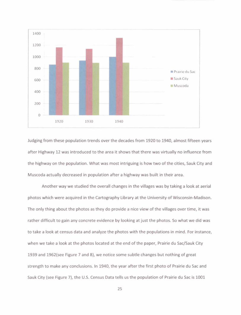
main roads such as state highways were introduced to these areas. In the year 1926, the
villages of Prairie du Sac and Sauk City saw the construction of a United States highway
completed and were introduced to u.s. Route 12 (Bessert, 2009). Muscoda which is west along
the river saw Highway 14 constructed near their village. Some would think that the introduction
of a major highway would result in a major population increase, however in the areas of Prairie
du Sac, Sauk City and Muscoda this was not the case. In the village of Prairie du Sac, the 1920
census showed a population of 866 people, 939 people in the first census after the highway was
built in 1930, and only 1,001 people in 1940 (U.S. Census Bureau). Sauk city actually sees a
decline from 1920 to 1930 as the population dropped from 1,162 people to 1,137 people (U.S.
Census Bureau). However, there was a significant increase according to the 1940 census with a
population of 1,325 people (U.S. Census Bureau). But then again when thinking about the
increase it really isn't that great of a jump as it comes out to under a twenty person increase
per year over that decade. Muscoda actually sees an overall decrease in population over the
two decades going from 903 people in 1920, to 900 people in 1930 and 902 people in 1940
(U.S. Census Bureau).
24
1400
1200
1000
800
600
400
200
o 1920
Pr,lirie du Sac
Sauk City
Muscoda
1930 1940
Judging from these population trends over the decades from 1920 to 1940, almost fifteen years
after Highway 12 was introduced to the area it shows that there was virtually no influence from
the highway on the population. What was most intriguing is how two of the cities, Sauk City and
Muscoda actually decreased in population after a highway was built in their area.
Another way we studied the overall changes in the villages was by taking a look at aerial
photos which were acquired in the Cartography Library at the University of Wisconsin-Madison.
The only thing about the photos as they do provide a nice view of the villages over time, it was
rather difficult to gain any concrete evidence by looking at just the photos. So what we did was
to take a look at census data and analyze the photos with the populations in mind. For instance,
when we take a look at the photos located at the end of the paper, Prairie du Sac/Sauk City
1939 and 1962(see Figure 7 and 8), we notice some subtle changes but nothing of great
strength to make any conclusions. In 1940, the year after the first photo of Prairie du Sac and
Sauk City (see Figure 7), the U.S. Census Data tells us the population of Prairie du Sac is 1001
25

people and Sauk City is 1,325 people as I mentioned earlier (U.S. Census Bureau). For the
second photo of that area, which was taken in 1962 (see Figure 8), we will use the 1960 census
data as our key, and in that time Prairie du Sac came in with 1,676 people and Sauk City had
2,095 (U.S. Census Bureau). Grant it these are some somewhat large increases with both being
over 600 people we must keep in mind that it is over a span of over twenty years. While
keeping that data in mind and taking a look at the two aerial photos we really don't see a whole
lot of change. The two villages gained some density over the two decades but when looking at it
there isn't much else to say about it.
The same can really be said of the town of Muscoda. The two aerial photos located at
the back are from 1940 and 1961(see Figure 9 and 10), so once again we will be using the data
from 1940 and 1960. At that time the populations were 902 people and 927 people respectively
(U.S. Census Bureau). Muscoda only sees a twenty five person increase in population over the
two decades and the photos really reveal the lack of population growth. When comparing the
two photos there really isn't much difference in the two except for some density in the
southwest corner of the village where it looks like there was a little development (see Figure
10). When thinking about the lack of concrete evidence we could gain from aerial photos
perhaps there just wasn't enough increase in either places population to see any real changes.
Given the short period of time that we actually got to spend on our research, it could
have been nice to look at some more recent photos to gain some more knowledge. For
instance, if we could have taken the time to look at Prairie du Sac and Sauk City after Highway
12 was expanded from two to four lanes in 2005, we may have seen some serious changes in
the area (see Figure 11). In this photo we see some substantial growth to the west of the city
26

and away from the river, which actually got us to start thinking about urban sprawl in the area.
The development on the western edge of the two villages appears to be houses and sub
divisions. So perhaps the introduction of the highways didn't have much effect, but the
expansion of them could bring some serious change and development.
Prairie du Sac and Sauk City are regarded as sister villages while both are situated on the
banks of the Wisconsin River with Prairie du Sac located just north of Sauk City. When talking
about the general area of the two it can be referred to as Sauk Prairie with a combined
population of about 6,300 people in 2000 according to their community profile (Sauk
City/Prairie du Sac Community Profile). Historically, the area got its name from the Sauk Indians
who once occupied the area and farmed the land. To this day the area is still home to many
great farms, a lot of which are still run by their original families. The area is located just twenty
five miles southeast of Wisconsin's state capital, Madison. The community is one that is large
enough to support enough businesses and services to provide for the area and yet it is small
enough to make it very comforting and friendly. Both communities support the relocations of
businesses to their downtowns and industrial parks which help to employ hundreds of local
jobs (Sauk City/Prairie du Sac Community Profile).
The leading employers in the area are the Sauk Prairie Memorial Hospital and the Sauk
Prairie School district which combine to employ 929 people (Sauk City/Prairie du Sac
Community Profile). Outside of those two the leading employer is Milwaukee Valve which
manufactures valves for the plumbing and heating industry while employing 340 people (Sauk
City/Prairie du Sac Community Profile). After that Fiskars Lawn and Garden Division handles
226 employees, Unity Health Plans 135 people, McFarlane's 110 people, the trucking company
27

Fuchs, Inc and Lycon both employ 100 people (Sauk City/Prairie du Sac Community Profile).
Muscoda was incorporated as a community in 1894 and used to be called English Prairie
until it was changed to Muscoda. The area was once a major Wisconsin River Port for the lead
mining industry, and once the railroad was introduced to the area the community shifted its
look to a north-south community according to the history of its village profile (Muscoda
Community Development Profile). The village of Muscoda remains a strong industrial and
farming community to this day.
Muscoda is a predominately industrial village with most of its leading employers in the
manufacturing or production industry. Their top employer is Scot Industries, which is a honing
company and they employ 160 people (Muscoda Community Development Profile). Second is
the areas school district with 125 employeesl followed by Universal Silencersl who manufacture
noise silencers with 70 people (Muscoda Community Development Profile). Following that the
Riverdale Health and Rehab Center handles 60 employeesl the local supermarket and Meister
Cheese Company employ 40 peoplel and after those employers three sawmills all employ
around 15-20 people (Muscoda Community Development Profile).
According to all the histories and profiles of all three areas, roads, including u.S.
Highway 12 and 14 did not have a major impact on the area or the employers. Most, if not all
the companies and industries in the area was either established before and has grown with the
times or established them well after the development of u.s. Highway 12. Populations didn/t
increase dramatically in either area after the introduction of highways; they only steadily
increased in the decades following. Thereforel highways didn/t have a major impact on the
areas or their populations.
28

Part IV: Looking To the Future
Although the area around the lower third of the Wisconsin River has been preserved for
20 years, the cities around the Riverway have seen limited yet consistent expansion. State
Highways 12, 14, 18 and 60 have all been major arteries for vehicle traffic in the area, servicing
the cities and surrounding areas of Prairie du Sac, Sauk City, Boscobel, and Prairie Du Chien.
With the continued expansion, the Wisconsin Department of Transportation is continually
planning to help make areas across the state more accessible to increased freight and vehicle
traffic.
The lower third of the Wisconsin River has already seen this expansion first hand with
the reconstruction of state highway 12 from Madison to Sauk City. Using highway 12 and its
current expansion as a model there is hope to find any effects that could be seen by a Highway
14 expansion. Also, with the application of WisDOT Connections 2030 program, which forecasts
the future of transportation expansions on statewide corridors, the entire region will be
affected in one or another by highway expansion and reconstruction. Finally, the opposite of
expansion is preservation. The State of Wisconsin has shown in this in its Scenic Byway program
which has expanded to include Highway 60.
Highway 12 crosses into Wisconsin near Genoa City on the Wisconsin/Illinois boarder
and exits the state headed into Minnesota in conjunction with 1-94 at Hudson. For this project
the focus area will be starting on the west side of Madison near the Parameter Street exit in
Middleton, continuing north east through Sauk City to the connection south of Wisconsin Dells.
Although a majority of the highway consists of two lanes, construction in 2002 transformed the
section from Middleton to Sauk City into an expressway. The proceedings leading up to this
29

construction were quite controversiat dating back to 1990 the WisDOT had to fight opposition
from local groups stating that expansion would encourage sprawl, take valuable farmland and
threaten the Baraboo hills natural national landmark. (Bessert, 2009) The opponents of the
expressway construction eventually made an agreement with WisDOT after there was an
agreement in place to pay five million towards preservation of the Baraboo Hills. (Bessert,
2009)
Currently WisDOT is looking into further expansion of the already redeveloped
expressway section between Middleton and WIS-19 in the Town of Springfield. WisDOT US-12
Freeway Conversion Study was started in late 2008 and will be headed by WisDOT project
manager Tom Korprowski. This study was created in order to anticipate the increased volume
of traffic Highway 12 will see with new growth and development in and around the roadway.
Its primary focus is to located high need areas including the existing "at-grade interchanges"
and their conversion to interchanges} overpasses} or roundabouts. (US-12 STUDY)
After speaking with the Highway 12 Project Manager about the project he made it clear
to me that the expansion of Highway 12 is seen as extremely important in the eyes of WisDOT.
In the long-term future WisDOT would like the see U5-12 become a freeway/expressway from
Madison to the intersection with 190/94 in Wisconsin Dells in order to have a parallel route to
the states most significant tourist destination. (Koprowski)
U5-12s current and future expansion will have a tremendous affect on the area} and
depending on the source those affects are quite different. According to WisDOT the US-12
expansion brings growth to the areas of Sauk City and Baraboo} and creates jobs for the
expansion projects. It also win decrease the time of travel while increasing the safety of travel
30

along the highway. (Koprowski) The Wisconsin Riverway Board also sees advantages in the
expansion of roads ways as the ease in travel will undoubtedly help the local economy with
tourism and agricultural economies. Yet, the new growth will affect the riverway through
development pressures on the scenic protection legislation that was put in place 20 years ago.
The Riverway Board also commented on the problems that could arise from an ease of
transportation including user conflicts to the riverway as more people attempt to take
advantage of recreation in the area. (Cupp)
A second US highway that runs through the project study area of the Lower third of the
Wisconsin River is U5-14. 14 enters the state south of Walworth at the Illinois state line and
leaves Wisconsin in the Minnesota state line in downtown La Crosse. WisDOT also has plans to
update the section from Middleton to Mazomanie by improving the existing the 2 lane highway
and put in full intersections with left turn lanes and medians. (Koprowski) Once the conversion
study plans are completed WisDOT will have a much better idea of what kind of expansion will
have to be seriously considered for the long term plans. As Part of the Wisconsin 2030
Connections program US-14 is expected to be turned into a 4 lane freeway between Middleton
and Cross Plains. This expansion project is mostly based off of WisDOT traffic predictions.
(WisDOT Connections 2030)
When asked about transportation impacts on the Lower Third of the Wisconsin
Riverway Koprowski responded by saying that their first goal is to avoid sensitive environmental
areas at all cost. They work closely with the DNR and local organizations and communities in
order to gain information on those wildlife areas when they are planning for new
transportation projects. WisDOT continues to create long-term plans for high priority
3~_----------------

transportation corridors with their connection 2030 program, but as can be seen from US-14
years of research and studies are needed in order for any new developments to be put into
action, and as of now it seems that the fate of how a U5-14 expansion would affect the Lower
Third of the Wisconsin River is still in limbo.
WisDOTs 2030 Programs affects can be seen in other influencing areas of the Lower
Third of the Wisconsin River. Two of the 37 system-level priority corridors throughout the state
directly affect the cities in and around our project study area. The 2030 Program is set up to
identify specific projects around the state to continue to improve the transportation
infrastructure, yet they are not guaranteed or IIshovel ready' projects, only
projections.(WisDOT Connections 2030) The first of the pair is what is labeled the Frank lloyd
Wright Corridor which links Madison to Richland Center to La Crosse. The study shows expected
populations of Sauk and Iowa counties to increase by 9,512 and 3,220 respectively by the year
2030 which in-turn will increase the average annual daily traffic along US-14 from between
2,100 - 12,400 in 2007 to 2,500 - 15,900 in 2030, as well as the previously mentioned
expansion plan from the current 2 lane highway to a new expressway/freeway along the entire
corridor. (WisDOT 2030 Frank Lloyd Wright)
The second of the pair is the French Fur Trade Corridor which stretches from Dodgeville
to Prairie du Chien along US-lB. This corridor is located along the original U.S. Military built
Military Ridge road. The study shows the expected populations of Crawford and Grant counties
to increase by 942 and 1,777 respectively, increasing the average annual daily traffic along US
18 from 2,800 - 7,600 in 2007 to 3,900 - 18,100 in 2030. WisDOT does not seem the kind of
growth along this corridor that it does with its neighboring Frank lloyd Wright corridor. Yet, it
32

still plans to construct passing lanes along the US-18 affected route to maintain infrastructure
preservation and continued use efficiency and mobility. (WisDOT 2030 French Fur Trade)
On April 27th 2009 the 100 mile stretch between Lodi and Prarie Du Chien of Highway 60
was dedicated as the first corridor to receive formal approval as a Wisconsin "Scenic Byway". A
scenic byway is described as road that is set aside to preserve, promote, and enhance historic
highways. The preservation project that was led by Mark Cupp and the Wisconsin Riverway
Board as part of their efforts to preserve the area around the Lower Third of the Wisconsin
River. The Scenic Byway designation is used as a tool to increase tourism, attract businesses
and recruit new employees. (lower Wisconsin Riverway Board)
Overall the Riverway has the opportunity to see many changes, including preservation,
in both the immediate and long term future. After conducting my interview with the project
manager of the WisDOT and Mark Cupp of the Lower Wisconsin Riverway Board it became
apparent that new highway construction is very important to the area. New construction can
and will put pressures on the scenic regulations along the Riverway. And although tourism is an
important piece of cities around the lower third of the Wisconsin River economies, the
residents have voiced strong opinions against turning it into another Wisconsin Dells. Which is
an over usage that could happen without regulation. Yet, the continued maintenance and
expansion of the areas roads is needed in order to keep the existing level of residential and
commercial travel at a high rate.
33

Part V: Conclusions
The Lower Wisconsin Riverway was once a prominent region within the state and its
territory. After improvements in transportation occurred making expansion beyond the
riverway much easier, the region began to die off. More than ease of transportation should be
used to explain this, however the automobile has a massive effect on the expansion of people
and the decline in importance of the region. As of late certain cities within the region have
experienced growth aligning with improvements in road networks stretching from Madison and
the Dane County area. It would not be foolish to believe as the Corridors project begins it's re
construction of the region that there will be effects on the development of the region,
especially along the new and improved lines of transportation. Possible links between
Madison, Prairie du Chien, Dubugue, Lacrosse, and the Twin Cities could create improved
transportation costs, lowering total household costs making it easier for people to live within
the region and being located within distance of a central city hub.
Part VI: Further Research
Due to the limitations of both time and money for this project our group feels that a
much stronger conclusion could be found if we could have been able to research further in four
specific areas. First, look at any changes in land use zoning in the five different cities we
researched. Focusing in on land that may have changed from commercial or agricultural zoned
to residential. Second, collect data on fluctuation of school enrollments at the district level. We
figure that any change in district enrollment could be used a supplemental form of the census
data to show population change. Third, Expand our research from focusing in on U.S. and State
34

highways to county and even city roads in order to show development on a more local scale. By
addressing these three questions as well as our original research question focusing on census
data we think that a clearer conclusion could be reached.
BIBLIOGRAPHY
1) FISHMAN, ROBERT. THE METROPOLITAN TRADITION IN AMERICAN PLANNING. WOODROW WILSON
CENTER PRES, 2000
2) SINCLAIR, ROBERT. VON THUNEN AND URBAN SPRAWL. ANNALS OF THE ASSOCIATION OF AMERICAN
GEOGRAPHERS, 1967
3) WISCONSIN STATE HISTORICAL SOCIETY. HISTORY EXPLORER> HIT THE ROAD: EARLY ROAD
DEVELOPM ENT, HTTP://WWW.WISCONSI NHISTORY.ORG/ARCHSTORI ES/EARLY_ROADS/INDEX.ASP
(ACCESSED 19 APRIL 09)
4} WISCONSIN STATE HISTORICAL SOCIETY. REFERENCE> REFERENCE MAPS,
HTTP://WWW.WISCONSINHISTORY.ORG/REFERENCE/MAPS/#EARLYNATIVEPEOPLES (ACCESSED 9 MAY 09)
5) ROMAN ROADS. HTTP://EN.WIKIPEDIA.ORG/WIKI/ROMAN_ROAD (ACCESSED 25 APRIL 09)
PART II
1} BESSERT, CHRISTOPHER J. WISCONSIN HIGHWAYS. "WISCONSIN HIGHWAYS HISTORICAL OVERVIEW."
<HTTP://WISCONSINHIGHWAYS.ORG/HISTORICAl_OVERVIEW.HTMl> (ACCESSED MARCH 29, 2009).
2) PRAIRIE DU CHIEN AREA CHAMBER OF COMMERCE. PRAIRIE DU CHIEN AREA CHAMBER OF COMMERCE
HISTORY. <HTTP://WWW.PRAIRIEDUCHIEN.ORG/VISITORS!HISTORY.HTM> (ACCESSED APRIL 3, 2009).
3) US CENSUS BUREAU 2000 CENSUS. SUMMARY FILE 1, 100-PERCENT DATA, DETAILED TABLES FOR
PRAIRIE DU CHIEN, WISCONSIN.
4) US CENSUS BUREAU 2000 CENSUS. SUMMARY FILE 1, lOO-PERCENT DATA, DETAILED TABLES FOR
CRAWFORD COUNTY, WISCONSIN.
5) US CENSUS BUREAU 2000 CENSUS. SUMMARY FILE I, 100-PERCENT DATA, DETAilED TABLES FOR
BOSCOBEL, WISCONSIN.
3S

6) US CENSUS BUREAU 2000 CENSUS. SUMMARY FILE 1, laO-PERCENT DATA, DETAILED TABLES FOR GRANT
COUNTY, WISCONSIN.
7) AERIAL IMAGE, CITY OF PRAIRIE DU CHIEN. DATE. ARTHUR H. ROBINSON MAP LIBRARY, UNIVERSITY OF
WISCONSIN-MADISON.
8) AERIAL IMAGE, CITY OF BOSCOBEL. DATE. ARTHUR H. ROBINSON MAP LIBRARY, UNIVERSITY OF
WISCONSIN-MADISON.
PART III
1} GRANT COUNTY ECONOMIC DEVELOPMENT CORPORATION. MUSCODA COMMUNITY DEVELOPMENT
PROFILE. COPYRIGHT 1997-2009. HTTP://WWW.MUSCODA.COM/CPROFILE.HTML (ACCESSED 6 APRIL
2009)
2) COMMUNITY PROFILE NETWORK, INC. & PROGRESSIVE PUBLISHING, INC. SAUK PRAIRIE~ SAUK
CITY/PRAIRIE DU SAC WISCONSIN. COPYRIGHT 2000.
HTrP://WWW.VILLAGEPROFILE.COM/WISCONSIN/SAUKPRAIRIE/MAIN.HTMl (ACCESSED 13 APRIL 2009)
3) US CENSUS BUREAU 2000 CENSUS. SUMMARY FILE 1, laO-PERCENT DATA, DETAILED TABLES FOR
MUSCODA, WISCONSIN.
4) US CENSUS BUREAU 2000 CENSUS. SUMMARY FilE 1, laO-PERCENT DATA, DETAILED TABLES FOR PRAIRIE
DU SAC, WISCONSIN.
5) US CENSUS BUREAU 2000 CENSUS. SUMMARY FILE 1, 100-PERCENT DATA, DETAILED TABLES FOR SAUK
CITY, WISCONSIN
PART IV
1) INTERVIEW: DEPARTMENT OF TRANSPORTATION: WISCONSIN, TOM KOPROWSKI - PROJECT MANAGER; E
MAIL: [email protected]. 22 APRIL 2009.
2) INTERVIEW: LOWER WISCONSIN RIVERWAY BOARD: WISCONSIN, MARK CUPP - BOARD DIRECTOR; E-MAIL:
[email protected]/ 12 APRIL 2009.
3) WISCONSIN DOT. US 12 FREEWAY CONVERSION STUDY: INFORMATION HANDOUT. PUBLIC INFORMATION
MEETING 28 OCTOBER 2008.
4) BESSERT, CHRISTOPHER. WISCONSIN HIGHWAYS HISTORY: HIGHWAY 12.31 JANUARY 2009.
HTIP://WWW.WISCONSINHIGHWAYS.ORG/USTINGS/WISCHWYS10-19.HTML (ACCESSED 9 MARCH 2009)
5) BESSERT, CHRISTOPHER. WISCONSIN HIGHWAYS HISTORY: HIGHWAY 14.31 JANUARY 2009.
HTTP://WWW.WISCONSINHIGHWAYS.ORG/USTINGS/WISCHwyslO-19.HTMl (ACCESSED 9 MARCH 2009)
36

6) WISCONSIN DOT. PLANS AND PROJECTS: CONNECTIONS 2030 SYSTEM-LEVEL PRIORITY CORRIDORS. 16 MARCH 2009. HTTP://WWW.DOT.WISCONSIN.GOV/PROJECTS/STATE/CONNECTIONS2030.HTM (ACCESSED
5 MARCH 2009)
7) WISCONSIN DOT. PLANS AND PROJECTS: CONNECTIONS 2030 FRENCH FUR TRADE CORRIDOR. 16 MARCH
2009. HTTP://WWW.DOT.WISCONSIN.GOV/PROJECTS/STATE/OOCS/CORRIOOR-FRENCH.PDF (ACCESSED 6 MARCH 2009)
8) WISCONSIN DOT. PLANS AND PROJECTS: CONNECTIONS 2030 FRANK LLOYD WRIGHT CORRIDOR. 16 MARCH 2009. HTTP://WWw .OOT.WISCONSIN.GOV/PROJECTS/STATE/OOCS/CORRIDOR-WRIGHT. PDF
(ACCESSED 6 MARCH 2009)
9) LOWER WISCONSIN STATE RIVERWAY BOARD. SCENIC BYWAYS.
HTIP://lWR.STATE.WI.US/SECTION.ASP?UNKID=1054&lOCIO=50 (ACCESSED 25 APRtl2009)
37
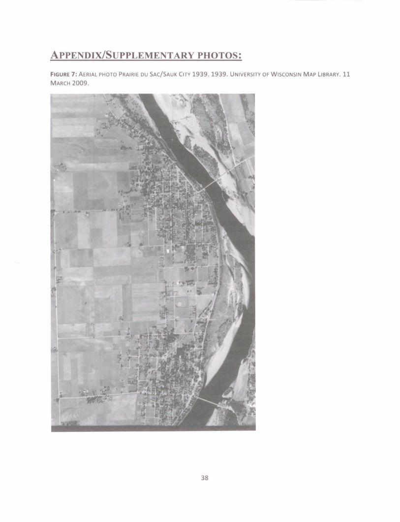
ApPENDIX/SUPPLEMENTARY PHOTOS:
FIGURE 7: AERIAL PHOTO PRAIRIE DU SAC/SAUK CITY 1939.1939. UNIVERSITY OF WISCONSIN MAP LIBRARY. 11 MARCH 2009.
38

FIGURE 8: AERIAL PHOTO PRAIRIE DU SAC/SAUK CITY 1962.1962. UNIVERSITY OF WISCONSIN MAP LIBRARY. 11
MARCH 2009.
39

FIGURE 9: AERIAL PHOTO MUSCODA 1940. 1940. UNIVERSITY OF WISCONSIN MAP LIBRARY. 11 MARCH 2009.
40

FIGURE 10: AERIAL PHOTO MUSCODA 1960. 1960. UNIVERSITY OF WISCONSIN MAP LIBRARY. 11 MARCH 2009.
41

FIGURE 11: AERIAL PHOTO PRAIRIE DU SAC/SAUK CITY 2005.2005. HTIP://RELlEF.ERSC.WISC.EDU/WISCONSINVIEW/SESSION.PHP 5 MARCH 2009.
42

FIGURES (12-16): MAPS, WISCONSIN STATE HISTORICAL SOCIETY, ACCESSED MAY 9, 2009.
http://www.WI seonSI nhistory.org/refe renee/rna ps/#ea r1ynativepeopl es
~r
• 'VII
II
... •. ~"_ IIl4oUloU
KU
Aml'rku Era Fur rd, :-.it • I 15-1 50
43

llG Nil
o . ·lM1.r.....
A ..... .....,........ .,'"
~111"." ....... J
Fen .
'enFen Cno
Mililary ;i-}
44

Raads, 1 &-1348
45

46
1M'. p. 15.

47