Embed Size (px)
Citation preview

485
HISTORY OF BUILDING THE MAIN DAMS AND RESERVOIRS
Gheorghe Romanescu, Ana-Maria Romanescu1, Gabriela Romanescu2 1”Alexandru Ioan Cuza” University of Iasi, Faculty of Geography and Geology, Department of Geography,
Carol I, 20A, 700505, Iasi, Romania, Email: [email protected] 2School Nr. 22 Bogdan Petriceicu Hasdeu, Str. Ion Creanga, 27, 700317, Iasi, Romania
Abstract
The large dams and reservoirs have multiple functions: hydropower, supply with drinking or industrial water, irrigations, pisciculture, leisure, etc. The oldest reservoirs date to the Antiquity (circa 4,000 years ago) and they were built by the Arabs. The most numerous are constructed in the areas with rain deficit: Moldavia (with the largest pond, Dracsani), the Transylvanian Plain, Dobroudja. The ones in the mountainous areas are mainly used to obtain electricity (Izvorul Muntelui, Vidra, Vidraru, etc). The largest water bodies in Romania are found in the Tulcea County (considering the existence of the Danube Delta), Iași and Botoșani (with few precipitations, but with many ponds). Most dams were built in the period 1960-1990. The oldest reservoir in Romania (Taul Mare) was built in 1740 in the Metaliferi Mountains. The most numerous reservoirs are located in the Siret hydrographical basin. The Prut River comprises the largest reservoir built on the Romanian rivers (Stânca-Costești). The oldest hydropower plant in Romania was built in 1890 on the Dâmbovita River (Bucharest). The Romanian territory has 246 large dams, more than half of which are less than 40 m high. Keywords: manmade dams, reservoirs, hydropower potential, water resources
1. INTRODUCTION
According to the definition provided by Forel, (1892) lake is “a body of standing water occupying a
basin and lacking continuity with the sea.” The term lake applies to all natural or artificial depressions
containing water, “with their own life and certain autonomy” (Dussart, 1992). According to the international
treatises on limnology, lake is “an inland body of water of considerable size” (International Glossary of
Hydrology, 1992) or “a sweet or salt water body which occupies a closed depression on the surface of a
continent” (Dictionnaire Encyclopédique Alpha, 1983).
By their nature, lakes can be natural or manmade (artificial). Concerning the artificial lakes, the
following characteristics are taken into account: purpose (hydropower, industrial or drinking water supply,
irrigations, pisciculture, leisure, balneotherapy, waste settling, mineral flotation, etc); size (first, the water
volume). The reservoirs in Romania comprise 13 billion m3 of water, which means 33% of the total water
volume transited within a year by the rivers draining the country’s territory (Jelev, 1992).
The category of artificial lakes tends to occupy a tremendous surface among all the lakes on Terra.
Currently, 40 artificial lakes exceed 1,000 km2 (a total of 114,000 km2) and their total volume is 1,675 km3.
Among these gigantic lakes, almost half belong to Russia (Volgograd, Kuibâşev, Ţimleask, Novosibirsk,
Krasnoiarsk, Bratsk), while the rest to the USA (Mead, Glen Canyon, Fast Peak, Garrison, Oahe), to Canada
(Pearce-Viuner Grew), to China (Three Gorges), to Argentina (Itaipu), to Egypt (Nasser), to Niger (Kandji),
to Zambia (Kariba), etc (Romanescu et al., 2013). The largest manmade lake is Volta, in Sahel, Africa (8,730
km2), while the one with the greatest volume is Bratsk, on the Angara River, with 169.4 km3 (Billington et
al., 2005; Biswas & Tortojada, 2001; Brandt & Hassan, 2000; Romanian Committee on Large Dams, 2000;
Dăscălescu, 2000; International Commission on Large Dams, 1999, 2010; Mermel, 1989; Romanian
National Committee on Large Dams, 2000; World Commission on Dams Regional Consultation, 1999;
World Commission on Dams, 2000a,b).
The disadvantages of reservoirs have often been underlined by the specialized literature, because the
anthropic activity does not always have positive outcomes: it produces alterations in the natural flow regime
of rivers and it presents a high impact on the environment by modifying the ecosystems, etc (Touchart,
2006). By building the dam of Assouan, on the valley of the Nile, its floodplain and delta no longer receive
enough alluvia. Because part of the waters of Don and Kuban are retained, the Sea of Azov receives a
smaller amount of water.
2. METHODOLOGY
The consultation of the specialized literature within international publications. The positioning of the
large dams and of reservoirs on a general map and comparing them by size, shape, utility, etc. The largest
2nd International Conference - Water resources and wetlands. 11-13 September, 2014 Tulcea (Romania); Available online at http://www.limnology.ro/water2014/proceedings.html Editors: Petre Gâştescu ; Włodzimierz Marszelewski ; Petre Bretcan; ISSN: 2285-7923; Pages: 485-492; Open access under CC BY-NC-ND license ;
486
dams and reservoirs in Romania were included into types and compared to the other ones in the world. In the
field of hydrotechnical works, Romania ranks high on a global scale, with a total of 246 large dams.
3. RESULTS AND DISCUSSIONS
The dam represents any hydrotechnical work with an existing or proposed structure, capable of
ensuring the permanent or temporary accumulation of water, of liquid or solid industrial waste deposited
underwater (from the chemical or energetic industry and from the mud settling ponds of the mining
industry), whose breaking can produce the uncontrolled loss of the accumulated content, with highly
significant negative effects upon the social, economic and/or natural environment (definition comprised in
the Emergency Ordinance no. 244/2000 on the safety of the dams – republished).
Figure 1. Distribution of large reservoirs and of the number corresponding to each State
(after Lehner et al., 2010)
The countries with an aggravated precipitation deficit – and liquid flow, implicitly – on the
hydrographical arteries are forced to build dams and reservoirs. The necessity of building dams in Romania
is due to the fact that 95% of the rivers are less than 50 km long. Only four Romanian rivers exceed 500 km
in length: Siret, Prut, Mureş and Olt. The mean multiannual flow of the Romanian rivers only reaches 1,172
m3/s, which means a volume of 37 million m3. The territorial repartition and the unequal flow regime
determine the rivers to supply an annual volume of only 5-6 million m3/s (Gâștescu, 1971; Gâștescu & Rusu,
1980; Rădoane & Rădoane, 2004; Romanescu, 2006; Șerban et al., 1989).
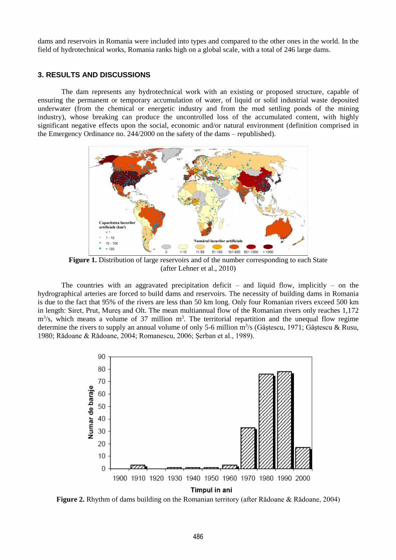
Figure 2. Rhythm of dams building on the Romanian territory (after Rădoane & Rădoane, 2004)

487
Figure 3. Number of the dams and their height, on the Romanian territory
(after Romanian Committee on Large Dams, 2000)
Most rivers in the Moldavian Plateau, Dobroudja and the Romanian Plain dry out in the summer and
they have no flow in the winter because waters are frozen. Only the rivers larger the fourth order – according
to the Horton-Strahler classification system – have a permanent flow (Romanescu, 2012). The first
(artificial) reservoirs were constructed during Antiquity; however, an intense increase in their number has
been registered in the past 60 years (Fig. 1). Most dams were built in the period 1980-1990. After the year
1990, no dams were built on the Romanian territory. Most dams in Romania have a height under 20 m (108),
while only two are more than 180 m high (Fig. 2). The most numerous reservoirs are situated in the Siret
hydrographical basin, followed at great distance by Olt, Argeş, Ialomiţa, Mureş, Jiu-Cerna, Someş, Crişuri,
etc (Fig. 3, 4). On the Prut River – the Romanian sector – only one dam was built: Stânca-Costești.
The latest archaeological excavations have brought to light vestiges of dams circa 4,000 years old.
They were built in the places with precipitation deficit, mainly in the Arab countries. They were used for the
water supply of settlements and for irrigations. Marib of Yemen is the best-preserved dam and it was built in
750 B.C. (Fig. 5, 6). The building process took around 100 years. The dam was 4 m high and it was made of
stone and clay. The ancient dam was elevated in the year 1968; currently, it is 38 m high. The lake
accumulates a water volume of 398 million m3.
Figure 4. Number of reservoirs in Romania on hydrographical basins (after Rădoane & Rădoane, 2004)

488
Figure 6. Inscriptions on the original stone of the Marib Dam,
built in 750 B.C. (after www.icold-cigb.org, 2013)
The reservoirs had the primordial role of supplying with water the human settlements in the droughty
period of the year. The oldest dam still in function was made of ripraps, in A.D. 1350, on the Syrian territory,
today Iran (Ben-e-Golestan) (Fig. 7). In 2280 B.C., a complicated system of dams and channels – unusable
today, unfortunately – was built on the Chinese territory.
The Sayamaike dam is the oldest on the Japanese territory, as it was constructed in the 7th century
A.D. (Fig. 8). It has suffered important alterations throughout the time, but it has always preserved its
complex use. On the territory of Sri Lanka, there are numerous inscriptions and chronicles attesting the
existence of the dams starting with the 6th century B.C. Most of them were destined to irrigations. One of the
largest dams (Nachchaduwa) was built during the reign of King Mahasen (A.D. 276-303), but it was
destructed in 1900. It was restored in 1901 and it is still active (Fig. 9). On the territory of Sri Lanka, over 50
old dams were restored.
Figure 7. The Ben-e-Golestan Dam in Iran, built Figure 8. Aerial image of the Sayamaike Lake
in A.D. 1350 (after www.icold-cigb.org, 2013) in Japan, built in the 7th century A.D.
(after www.icold-cigb.org, 2013)
The old system of building the dams – with slopping walls and weir for high waters – was preserved
until the contemporary period (Fig. 10, 11, 12). Unfortunately, the material used has not always been the
best, reason for which certain dams broke. The Roman system of dam building was based on the small
heights of the crest. The most famous dam is Cornalbo, in Spain: it was 24 m (78 feet) high and 185 m (606
feet) long.
After the Roman period, for a relatively long time, in Spain only small-sized dams were built, while
large dams began to be built starting with the 16th century. In the 19th century, the European engineers
managed to build dams 45-60 m high (150-200 feet).
Figure 5. Dam of the Marib Lake in
Yemen, reconstructed in 1968 (after
www.icold-cigb.org, 2013)
489
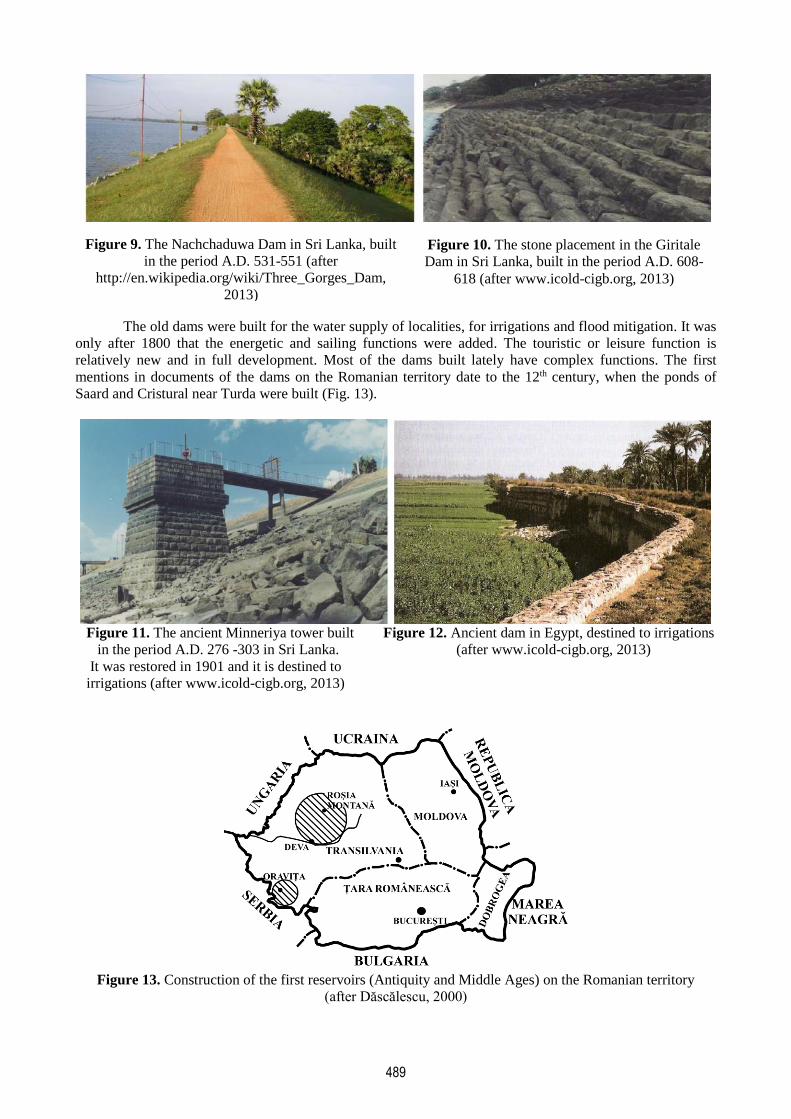
The old dams were built for the water supply of localities, for irrigations and flood mitigation. It was
only after 1800 that the energetic and sailing functions were added. The touristic or leisure function is
relatively new and in full development. Most of the dams built lately have complex functions. The first
mentions in documents of the dams on the Romanian territory date to the 12th century, when the ponds of
Saard and Cristural near Turda were built (Fig. 13).
Figure 11. The ancient Minneriya tower built Figure 12. Ancient dam in Egypt, destined to irrigations
in the period A.D. 276 -303 in Sri Lanka. (after www.icold-cigb.org, 2013)
It was restored in 1901 and it is destined to
irrigations (after www.icold-cigb.org, 2013)
Figure 13. Construction of the first reservoirs (Antiquity and Middle Ages) on the Romanian territory
(after Dăscălescu, 2000)
Figure 9. The Nachchaduwa Dam in Sri Lanka, built
in the period A.D. 531-551 (after
http://en.wikipedia.org/wiki/Three_Gorges_Dam,
2013)
Figure 10. The stone placement in the Giritale
Dam in Sri Lanka, built in the period A.D. 608-
618 (after www.icold-cigb.org, 2013)

490
The oldest reservoir (Tăul Mare), still in function, dates to 1740 and it was built in the Metaliferi
Mountains, for the gold mines. The first ponds for felt mills date to the year 1448 and they were quite
numerous in the Braşov area. In the period 1503-1550, there were 28 ponds. The ponds in Moldavia are
mentioned in documents starting with the 15th-16th centuries. The first ponds mentioned in documents are the
following: Hârlău, Belceşti, Şipote, Dinischean, etc. During the reign of Vasile Lupu, Lake Dracşani was
extended; it is the largest such pond in Romania, with a surface of 486 ha and a volume of 5.5 million m3. On
Bawr’s map, (1781-1797) there were 134 ponds, while on the one of Otzellowitz (1790) – 372 ponds. On the
Russian map – edited in 1850 – 126 ponds were represented, while the map of 1850-1900 already included
1,144 ponds (Băican, 1970).
Figure 14. Distribution by area of the large-sized lakes in Moldavia
The first hydropower plants were built at the end of the 19th century: Bucharest (1890) on
Dâmboviţa; Sadu (1896) in the Sibiu County. Until 1940, 128 hydropower plants were built. The largest
reservoirs began being constructed in 1960, when the hydropower plant of Stejaru, on the Bistriţa River, was
inaugurated (it includes the reservoir Izvorul Muntelui). The climax of the hydropower hydrotechnical works
was recorded in the period 1980-1990, when 78 hydropower plants were inaugurated.
The tradition of hydrotechnical works and the value of the Romanian school in the field have been
acknowledged by the International Commission on Large Dams, which includes 80 countries. Romania ranks
the 19th by total number of the dams and the ninth in Europe (Romanescu et al., 2013). On the Romanian
territory, there are 246 large dams, of which half are less than 40 m high. The highest dam on the Romanian
territory is Gura Apelor, on Pârâul Mare, in the Retezat Mountains: 168 m. Other 1,500 dams are less than 15
m high, while the reservoirs comprise a volume below 1 million m3 (Rădoane and Rădoane, 2004, 2005).
Most large-sized lakes in Moldavia are manmade, only a few are natural (Lala, Buhăescu, Red Lake, Crucii,
St Ana) (Fig. 14).
4. CONCLUSIONS
The dams and reservoirs have been built for multiple purposes: supply with drinking or industrial
water, irrigations, water for animals, pisciculture, hydropower, transport, leisure, etc. The first reservoirs
were built in the Near and Middle East, because of the water deficit. The first ponds on the Romanian
territory were constructed in the Moldavian Plain and they were mentioned in documents as early as the
reign of Stephen the Great. The most numerous and the largest ponds in Romania are situated in the
Moldavian Plain (counties of Botoșani and Iași) and in the Transylvanian Plain (counties of Cluj and Mureș).
The current reservoirs are large-sized and they have complex functions. The largest are used mainly
for hydropower. They are built in mountainous or isolated areas because they occupy significant surfaces
(North America, Asia, South America, etc). On the Romanian territory, there are 246 large-sized dams which
harbour reservoirs comprising important water reserves.

491
Acknowledgments. Our thanks go to the Geo-archaeology Laboratory within the Faculty of Geography and
Geology, “Alexandru Ioan Cuza” University of Iasi, which provided the tools and carried out the processing
of the data.
REFERENCES
Băican, V. (1970), Iazurile din partea de est a României oglindite în documentele istorice și cartografice din
sec. XV-XIX. Scientific Annals of the Alexandru Ioan Cuza University, II, XVI.
Billington, D.P., Jackson, D.C., Melosi, M.V. (2005), The history of large federal dams: planning, design,
and construction in the era of big dams. U.S. Department of the Interior, Denver, Colorado.
Biswas, K. & Tortojada, C. (2001), Development and Large Dams: A Global Perspective. Water Resources
Development, 17(1):9-21.
Brandt, S.A. & Hassan, F. (2000), Dams and Cultural Heritage Management. World Commission on Dams,
Cape Town.
Dăscălescu, N. (2000), History of Dam Construction in Romania. Romanian National Committee on Large
Dams, Bucharest, 16-26.
Dictionnaire Encyclopédique Alpha. (1983), Dictionnaire Encyclopédique Alpha, vol.1-24. Editions
Grammont S.A. Lausanne.
Dussart, B. (1992), Limnologie. L’etude des eaux continentales. Editions Boubee, Paris
Forel, F.A. (1892), Le Leman: monographie limnologique. Tome I. Bull. Soc. Vaud. Sci. Nat. Lausanne, 10.
Gâștescu, P. (1971), Lacurile din România – limnologie regională. Romanian Academy Publishing House,
Bucharest.
Gâștescu, P. & Rusu, C. (1980), Evaluarea resurselor de apă din râuri și amenajarea bazinelor hidrografice
în Romania. Terra, XII(XXXII), 2.
International Commission on Large Dams. (1999), Benefits and Concerns About Dams. Committee on Public
Awareness and Education.
International Commission on Large Dams. (2010), Dams and the World’s Water. Paris.
International Glossary of Hydrology. (1992), International Glossary of Hydrology. World Meteorological
Organization.
Jelev, I. (1992), Conferinţa Naţiunilor Unite pentru mediu şi dezvoltare, Rio de Janeirio, June 1992. Mediul
Înconjurător, III(3): 3-8.
Lehner, B., Reidy Liermann, C., Revenga, C., Vörösmarty, C., Fekete, B., Crouzet, P., Döll, P., Endejan, M.,
Frenken, K., Magome, J., Nilsson, C., Robertson, J., Rödel, R., Sindorf, N., Wisser, D. (2010), High
resolution mapping of the world’s reservoirs and dams for sustainable river flow management. GWSP-
GCI Workshop, The Global Dimenssions of Change in River Basins, Bonn, 2010.
Mermel, T.M. (1989), Major Dams of the World-1989. Water Power and Dam Construction Hand Book, 50-
56.
Rădoane, N.& Rădoane, M. (2004), Lacurile de baraj din bazinul râului Siret. Annals of the “Ştefan cel
Mare” University, 13: 77-88.
Rădoane, M. & Rădoane, N. (2005), Dams, sediment sources and reservoir silting in Romania.
Geomorphology, 71: 112-125.
Romanescu, G. & Lasserre, F. (2006), Le potentiel hydraulique et sa mise en valeur en Moldavie Roumaine.
In: Politiques de l’eau. Grands principes et réalités locales, Eds. A. Brun, F. Lassere. Presses de
l’Université du Québec, 325-346.
Romanescu, G., Stoleriu, C.C. & Enea, A. (2013), Limnology of the Red Lake, Romania. An Interdisciplinary
Study. Springer, Dordrecht.
Romanian Committee on Large Dams. (2000), Dams in Romania. Romanian National Committee on Large
Dams, Bucharest.
Romanian National Committee on Large Dams. (2000), Dams in Romania. Romanian Waters National
Administration, Bucharest.
Șerban, G., Sorocovschi, V. & Fodorean, I. (2004). Riscuri induse de amenajarea hidrotehnica a iazurilor de
pe Valea Șesului (Campia Transilvaniei). Risks and catastrophes, 1: 159-172.
Touchart, L. (2006), Lacs et risques. Un essai de typologie. Risks and catastrophes, 5(3): 13-20.
World Commission on Dams Regional Consultation. (1999), Large Dams and Their Alternatives in Latin
America, Experiences and Lessons Learned. World Commission on Dams.

492
World Commission on Dams. (2000a), Dams and Cultural Heritage Management. Final Report. Vlaeberg,
Cape Town, South Africa.
World Commission on Dams. (2000b), Dams and Development: a new framework for decision-making.
Earthscan Publications Ltd., London.
http://en.wikipedia.org/wiki/Three_Gorges_Dam, 2013
www.icold-cigb.org, 2013