Embed Size (px)
Citation preview

804 N. 2nd Ave. E.Rock Rapids, IA 51246-1759
800-622-3070www.aop.com
GEOGRAPHYHISTORY &STUDENT BOOK
6th Grade | Unit 1

HISTORY & GEOGRAPHY 601 World Geography
INTRODUCTION |3
1. MAPPING THE EARTH 5
LATITUDE AND LONGITUDE |6 TIME ZONES |8 MAPS |9 SELF TEST 1 |12
2. THE WESTERN HEMISPHERE 14
NORTH AMERICA |15 SOUTH AMERICA |18 SELF TEST 2 |20
3. THE EASTERN HEMISPHERE 22AFRICA |23 EUROPE |25 ASIA |26 SELF TEST 3 |28
4. THE SOUTHERN HEMISPHERE 30AUSTRALIA |31 ANTARTICA |32 SELF TEST 4 |34
5. POLITICAL AND CULTURAL REGIONS 36ANGLO-AMERICA |37 LATIN AMERICA |37 AFRICA |39 EUROPE |40 THE MIDDLE EAST |42 EASTERN AND SOUTHERN ASIA |44 NORTHERN ASIA |46 AUSTRALIA AND NEW ZEALAND |48 SELF TEST 5 |50
LIFEPAC Test is located in the center of the booklet. Please remove before starting the unit.
Unit 1 | World Geography
Section 1 |1

804 N. 2nd Ave. E. Rock Rapids, IA 51246-1759
© MCMXCVI by Alpha Omega Publications, Inc. All rights reserved. LIFEPAC is a registered trademark of Alpha Omega Publications, Inc.
All trademarks and/or service marks referenced in this material are the property of their respective owners. Alpha Omega Publications, Inc. makes no claim of ownership to any trademarks and/or service marks other than their own and their affiliates, and makes no claim of affiliation to any companies whose trademarks may be listed in this material, other than their own.
Author: Theresea Kay Buskey, B.A., J.D. Editor: Richard W. Wheeler, M.A.Ed. Revision Editor: Alan Christopherson, M.S.
MEDIA CREDITS: Page 15: © Soft_Light, iStock, Thinkstock; © vizualbyte, iStock, Thinkstock; 23: vizualbyte, iStock, Thinkstock; 25: © lorenzoantonucci, iStock, Thinkstock; 26: © Iakov Filimonov, iStock, Thinkstock; 32: © axily, iStock, Thinkstock; 45: © XiXinXing, iStock, Thinkstock; 46: © iSailorr, iStock, Thinkstock; 48: © idizimage, iStock, Thinkstock; © idizimage, iStock, Thinkstock
World Geography| Unit 1
2| Section 1

World Geography
Introduction Geography is the study of the earth; its surface, climate, continents, countries, peoples, industries, and products. In this study of world geography, you will learn about the physical and climatic characteristics of continents and about the development of the people in those regions.
First, we will learn about longitude and latitude. Then we will study the different maps of the earth and the hemispheres. A hemisphere is an imaginary division of the earth into halves. Finally, we will look into the political and cultural regions in our world.
ObjectivesRead these objectives. The objectives tell you what you will be able to do when you have successfully completed this LIFEPAC. When you have finished this LIFEPAC, you should be able to:
1. Define latitude and longitude and tell how they are used to locate places in the world.
2. Explain and identify time zone.
3. Identify the different ways to map the earth.
4. Locate and name the continents of the world and the oceans that surround them.
5. Name many of the important mountain ranges, highlands, and lowlands of the continents and tell of their effect on life in those regions.
6. Locate the great rivers of the earth and tell how they have affected the development of those regions.
7. Describe the general climate of regions.
8. Tell of the cultural lives of people in various regions.
9. Tell of the relationship between countries and the political ties involved.
Unit 1 | World Geography
Section 1 |3

Survey the LIFEPAC. Ask yourself some questions about this study and write your questions here.
_________________________________________________________________________________________________________
_________________________________________________________________________________________________________
_________________________________________________________________________________________________________
_________________________________________________________________________________________________________
_________________________________________________________________________________________________________
_________________________________________________________________________________________________________
_________________________________________________________________________________________________________
_________________________________________________________________________________________________________
_________________________________________________________________________________________________________
_________________________________________________________________________________________________________
_________________________________________________________________________________________________________
_________________________________________________________________________________________________________
_________________________________________________________________________________________________________
_________________________________________________________________________________________________________
_________________________________________________________________________________________________________
_________________________________________________________________________________________________________
_________________________________________________________________________________________________________
_________________________________________________________________________________________________________
_________________________________________________________________________________________________________
World Geography| Unit 1
4| Section 1

1. MAPPING THE EARTHYou will learn about latitude and longitude in this part of your study.
Section ObjectivesReview these objectives. When you have completed this section, you should be able to:
1. Define latitude and longitude and tell how they are used to locate places in the world.
2. Explain and identify time zone.
3. Identify the different ways to map the earth.
VocabularyStudy the following words to enhance your learning success in the following section.
equator (i kwā’ tur). An imaginary line running around the center of the earth.
geography (jē og’ ru fē). The study of the earth’s surface, climate, continents, countries, peoples, industries, and products.
globe (glō b). A sphere with a map of the earth on it.
International Date Line (in’ tur nash’ u nul dāt lin). Imaginary line agreed upon as the place where each calendar day begins.
latitude (lat’ u tüd). Imaginary line running east and west which measures the distance north or south of the equator.
longitude (lon’ ju tüd). Imaginary line running north and south which measures the distance east or west of the prime meridian.
Prime Meridian (prīm mu rid’ ē un). Meridian from which the longitude east and west is meas-ured. It passes through Greenwich, England, and its longitude is 0°.
rotate (rō ’ tāt). To move around a center or axis.
Note: All vocabulary words in this LIFEPAC appear in boldface print the first time they are used. If you are not sure of the meaning when you are reading, study the definitions given.
Pronunciation Key: hat, āge, cãre, fär; let, ēqual, tėrm; it, īce; hot, ōpen, ôrder; oil; out; cup, p .
ut, rüle; child; long; thin; /ŦH/ for then; /zh/ for measure; /u/ represents /a/ in about, /e/ in taken, /i/ in pencil, /o/ in lemon, and /u/ in circus.
Unit 1 | World Geography
Section 1 |5

LATITUDE AND LONGITUDEGeography is the study of the earth. The word comes from a Greek word geographia which is translated earth description. In order to study the earth, geographers have created a system of imaginary lines to locate different places on the planet.
The earth we live on is an almost perfect sphere that rotates daily on its axis. The axis is an imaginary line that runs through the cen-ter of the earth from top to bottom. It passes through both the North and the South Poles. The Poles are imaginary points marking the “top” and “bottom” of our earth. If the earth were a basketball spinning on someone’s fin-ger, the finger would be the bottom of the axis, at the South Pole.
Another important imaginary line is the equa-tor. It circles the center of the earth halfway between the two poles. The equator divides the earth into two halves, the northern and southern hemisphere (half-sphere). The area around the equator is the warmest on earth while the areas around the poles are the coldest.
The force of our planet’s rotation causes the earth to flatten out just slightly on the top and bottom. It also bulges just slightly in the middle. Thus, the circumference of the earth is slightly
greater around the equator than it is running through the poles.
Like every house on your street has an address, every single spot on earth has an address. Any place on earth can be located by longitude and latitude. These are imaginary lines used to create an address for any point on earth
Lines of longitude run from the North to the South Pole. These lines, called meridians, have a beginning and an end at the poles. Meridi-ans divided the earth into 360°, the number of degrees in a circle.
One of the lines of longitude had to be chosen as a starting point for counting purposes. The geographers choose the meridian that runs through the town of Greenwich, England as the Prime, or first, Meridian. The Prime Meridian is 0° longitude. Every place on earth is located by the number of degrees east or west of the Prime Meridian, up to 180°, which is half of the total 360° in a circle. Halfway around the world the lines of east and west meridian meet at the International Date Line. The International Date Line is 180° both east and west longitude.
Latitude lines are circles that run around the earth from east to west. Unlike meridians, they do not meet at any point. Lines of latitude are
100°W 50°W 20°W 0° 20°E 80°E
80°N60°N
45°N30°N20°N
0°
20°S30°S45°S
60°S80°S
World Geography| Unit 1
6| Section 1

therefore called parallels, because they are parallel to each other. Parallels also divide the earth into 360°. The equator is 0° latitude. All points on earth are a number of degrees north or south of the equator.
The North Pole is 90° north latitude. The South Pole is 90° south latitude. Since the Poles are only one-fourth of the way around the globe from the equator, 90° or one-fourth of the 360° in a full circle is the largest number of degrees latitude can have.
Degrees of latitude and longitude are divided even further to be more accurate if it is needed. Each degree is divided into sixty minutes (“) and each minute into sixty seconds (‘). Thus, using latitude and longitude, any point on earth can be accurately numbered. For example, a spot near New Orleans might be 30° north latitude, 89° 55” 15’ west longitude.
Look at The North Sea map. It shows some of the countries in northern Europe near the Prime Meridian. The country of Denmark is located at about 10° east longitude because it is that far east of the Prime Meridian. Iceland
is located at about 70° north latitude because it is that far north of the equator. The location 60° north latitude, 10° east longitude pinpoints the exact spot where those two lines cross in Norway.
Complete the following sentences.
1.1 Imaginary lines running east and west around the earth are called lines of ________________ or
__________________ .
1.2 The line that divides the world into northern and southern hemispheres is
called ________________________ .
1.3 The lower the number of degrees of latitude, or the closer to the equator, the
________________________ the temperature is.
1.4 The higher the number of degrees of latitude, or the closer to the poles, the
________________________ the temperature is.
1.5 Imaginary lines running north and south are called lines of __________________ or
__________________ .
1.6 The _____________________________________________________________ is located at 180° longitude.
| The North Sea
Iceland
10O
0O
10O
80O
60O
Ireland
UnitedKingdom
Denmark
Norway
Sweden
N. Latitude
North Sea
Prim
e M
erid
ian
Unit 1 | World Geography
Section 1 |7

TIME ZONESAs the earth spins on its axis different parts of the world have different times of day. When it is the middle of the day in the United States, it is the middle of the night in Asia, halfway around the world. Thus, it can not be the same time all over the world.
Time changes by an hour for every 15° of lon-gitude on the globe. These 15° wide time slots are called time zones. There are twenty-four of them for the entire earth. One for each of the hours in the earth’s rotation.
Time zones do not follow the meridians exactly because often they would divide towns into dif-ferent zones. Therefore, time zone lines often move to match city, state, or national bound-aries. Sometimes countries decide to set the boundaries or the times within them for their own reasons. In China, for example, the whole country is in the same time zone as the capital
Beijing because that is what the government wants.
The country of Nepal sets its clocks 10 minutes later than its large neighbor, India, as an act of independence. However, time zones always move back to the proper meridian whenever they can, like in the open ocean.
The continental United States has four time zones—Pacific, Mountain, Central, and Eastern. Alaska and Hawaii are each in their own time zone (Alaskan and Hawaii-Aleutian). A piece of western Alaska is in Hawaiian time. Thus, the entire United States is six time zones wide.
The International Date Line is also the edge of a time zone; however, crossing it changes the date as well as the hour. Crossing the Date Line going west makes it one day later, while cross-ing it going east makes it a day earlier. Thus, if it is Sunday in Alaska, it is Monday in Russia, across the Date Line.
1.7 The ____________________________________ is 0° longitude.
1.8 The ____________________________________ is 0° latitude.
1.9 The ____________________________________ is at 90° north latitude.
1.10 The shape of the earth is an almost perfect __________________________________________ .
Answer these questions.
1.11 What are the four time zones in the continental United States?
a. __________________________________________ b. __________________________________________
c. __________________________________________ d. __________________________________________
1.12 What are the two other time zones of the United States?
a. __________________________________________ b. __________________________________________
1.13 How many time zones are there on earth? _______________________
1.14 How many degrees of longitude are in each time zone? _______________________
1.15 What two things change when you cross the International Date Line? _________________________
________________________________________________________________________________________________
World Geography| Unit 1
8| Section 1
MAPSThe best map of the earth is a globe. That is because a globe is the same spherical shape as the earth. A globe can show the continents and oceans as they would look from outer space. A globe can also be used to model how the earth rotates and moves around the sun.
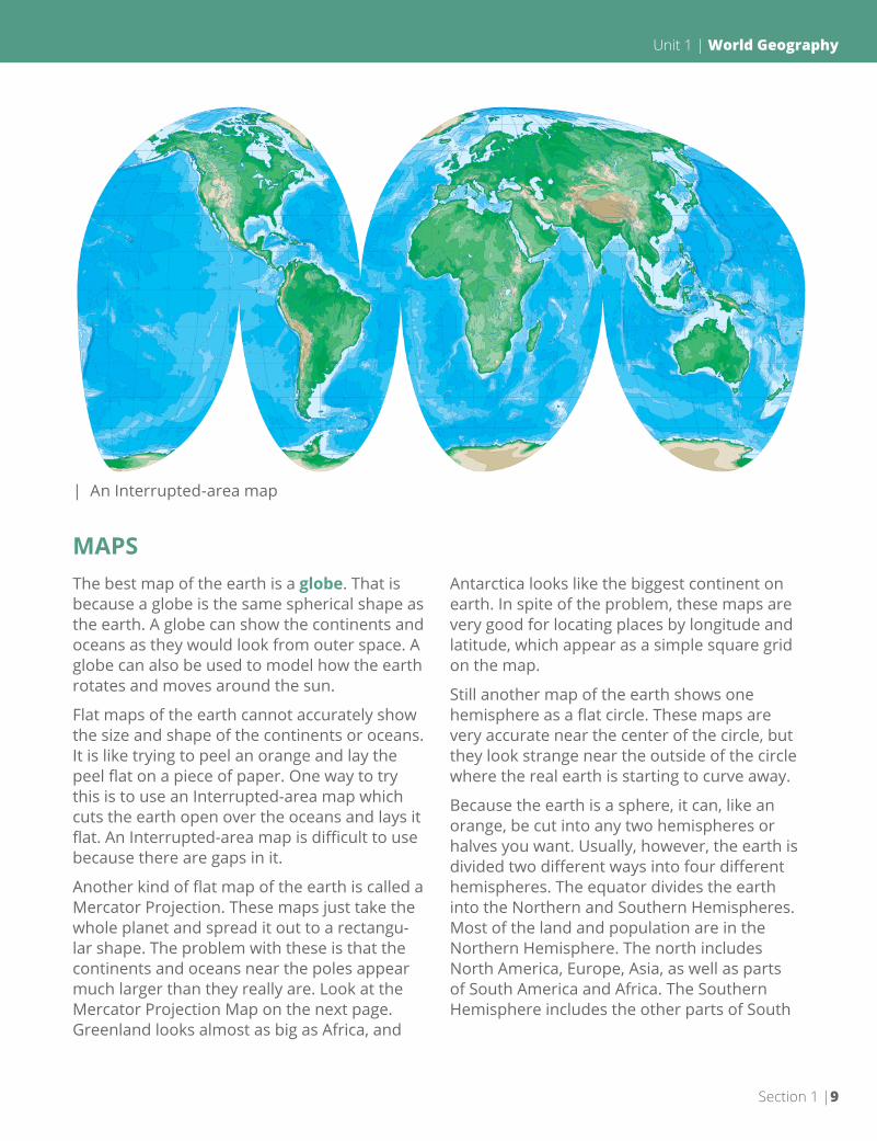
Flat maps of the earth cannot accurately show the size and shape of the continents or oceans. It is like trying to peel an orange and lay the peel flat on a piece of paper. One way to try this is to use an Interrupted-area map which cuts the earth open over the oceans and lays it flat. An Interrupted-area map is difficult to use because there are gaps in it.
Another kind of flat map of the earth is called a Mercator Projection. These maps just take the whole planet and spread it out to a rectangu-lar shape. The problem with these is that the continents and oceans near the poles appear much larger than they really are. Look at the Mercator Projection Map on the next page. Greenland looks almost as big as Africa, and
Antarctica looks like the biggest continent on earth. In spite of the problem, these maps are very good for locating places by longitude and latitude, which appear as a simple square grid on the map.
Still another map of the earth shows one hemisphere as a flat circle. These maps are very accurate near the center of the circle, but they look strange near the outside of the circle where the real earth is starting to curve away.
Because the earth is a sphere, it can, like an orange, be cut into any two hemispheres or halves you want. Usually, however, the earth is divided two different ways into four different hemispheres. The equator divides the earth into the Northern and Southern Hemispheres. Most of the land and population are in the Northern Hemisphere. The north includes North America, Europe, Asia, as well as parts of South America and Africa. The Southern Hemisphere includes the other parts of South
| An Interrupted-area map
Unit 1 | World Geography
Section 1 |9

America and Africa as well as Australia and Antarctica.
The other way that the earth is often divided is into the Eastern and Western Hemispheres very roughly along the Prime Meridian and the
International Date Line. This is more of a polit-ical division. The west includes the Americas while the Eastern Hemisphere includes Europe, Asia, Africa, and Australia. The Western Hemi-sphere is the New World while the Eastern is the old.
| A Mercator Projection Map
World Geography| Unit 1
10| Section 1

Choose the word(s) that the phrase describes. Some will be used more than once.
a. globe b. Mercator Projection c. Interrupted-area d. Eastern e. Western f. Southern g. Northern
1.16 ________ Best map of the earth
1.17 ________ The equator divides the earth into these two hemispheres
1.18 ________ The Prime Meridian is roughly one of the dividing lines for these two hemispheres
1.19 ________ Longitude and latitude form a simple square grid
1.20 ________ Gaps in the map allow it to lay flat
1.21 ________ Places near the poles look much bigger than they really are
1.22 ________ Most of the population and land is in this hemisphere
1.23 ________ This hemisphere includes only the Americas
1.24 ________ Map that is the same shape as the earth
1.25 ________ Hemisphere that includes all of Africa, Asia, and Europe
Review the material in this section in preparation for the Self Test. The Self Test will check your mastery of this particular section. The items missed on this Self Test will indicate spe-cific areas where restudy is needed for mastery.
Unit 1 | World Geography
Section 1 |11

SELF TEST 1
Complete these sentences (each answer, 4 points).
1.01 ________________________ is the study of the earth.
1.02 The ________________________ is the imaginary line that runs around the earth halfway
between the two poles.
1.03 The ________________________________ is the imaginary line that runs through the earth
between the North and South Pole.
1.04 The _______________________________ Line is the point on earth where each new date begins.
1.05 The ______________________________________________ is located at 90° south latitude.
1.06 The ______________________________________________ is 0° latitude.
1.07 There are (how many?) _________________ time zones on earth.
1.08 The best map of the earth is a _____________________________________ .
1.09 The ____________________________________________ is 0° longitude.
1.010 Lines of ________________________________ run north and south and are also called
______________________________ .
1.011 Lines of _____________________________________________ run east and west and are also called
______________________________ .
1.012 Crossing the _____________________________________ changes the date as well as the hour.
1.013 The shape of the earth is an almost perfect ___________________________________ .
Choose the hemisphere that best fits the description (each answer, 3 points).
Western Eastern Southern Northern
1.014 ____________________ Has most of the earth’s land and population.
1.015 ____________________ All of Antarctica.
1.016 ____________________ All of Africa, Asia, and Europe.
1.017 ____________________ The New World.
World Geography| Unit 1
12| Section 1
Answer true or false (each answer, 2 points).
1.018 ____________ The earth rotates once every twenty-four hours.
1.019 ____________ It tends to be cooler the closer one gets to the equator.
1.020 ____________ Longitude can be counted as high as 210°.
1.021 ____________ Longitude and latitude are measured in degrees,minutes, and seconds.
1.022 ____________ Time changes one hour for every 20° of latitude.
1.023 ____________ The entire United States covers six time zones.
1.024 ____________ It is easy to show the earth on a flat map.
1.025 ____________ The earth bulges out slightly at the poles.
1.026 ____________ Antarctica is touched by both 30° west longitude and 30°east longitude.
1.027 ____________ 30° west longitude cannot be in Asia.
SCORE TEACHERinitials date
7492
Unit 1 | World Geography
Section 1 |13
804 N. 2nd Ave. E.Rock Rapids, IA 51246-1759
800-622-3070www.aop.com
GEOGRAPHYHISTORY &STUDENT BOOK
ISBN 978-0-86717-551-6
9 7 8 0 8 6 7 1 7 5 5 1 6
HIS0601 – Apr ‘15 Printing