Embed Size (px)
Citation preview

Davidsonia 19:1 3
Ted Lea, Vegetation Ecologist, Ecosystems Branch, British Columbia Ministry of Environment
Victoria, BC Canada [email protected]
Historical (pre-settlement) Ecosystems of the Okanagan Valley and Lower Similkameen Valley of British Columbia – pre-European
contact to the present
Abstract
A series of maps compare the 1800, 1938 and 2005 ecosystems in the Okanagan and Lower Similkameen Valleys. Much of the gentle slope valley bottom ecosystems have been replaced by urban and agricultural development. Analysis of the areal extent of historical and remaining areas has been done for specific eco-system types that are important for many species at risk and are themselves ecosystems at risk. These include: Douglas-fir – pine-grass gentle slope; Ponderosa pine – bluebunch wheatgrass gentle slope; water birch – red-osier dogwood wetland riparian shrub; black cottonwood – red-osier dogwood floodplain; the Okanagan River ecosystem; cattail marsh; Idaho fescue – bluebunch wheat-grass grassland; big sagebrush shrub-steppe and antelope-brush – needle-and-thread grass shrub-steppe. For two of these eco-systems, over 90 percent of the original ecosystem has been lost.
Uses of this mapping for conservation of species at risk are presented, including applications to status assessment, quantifica-tion of threats, informing restoration projects, and providing data on the importance of the remaining areas of ecosystems that have been severely depleted. The paper concludes that it is important to focus on conservation of ecosystems in order to maintain spe-cies at risk.
Introduction“Until recently, most measures to save declining species have been upside
down. Typically, what happens is that ecosystems are degraded without public

4
Figure 1. Location of the Okanagan and Similkameen valleys.
concern until some of their component species approach extinction. It is gross-ly inefficient to wait until species are endangered and then work backwards to try to protect their habitat. Instead, conservation efforts should pre-emptively identify all ecosystems in present or potential danger and act decisively to save them before further decline. By conserving adequate expanses of all types of ecosystems, we would ensure that many vulnerable species are stabilized before listing is needed.”
America’s Endangered Ecosystems by Robert Peters and Reed Noss (1995)
The Okanagan and Similkameen valleys occur in the south central area of British Columbia (BC), Canada (Figure 1, 1). They
1. Due to format limits, all maps in this article have been adjusted by the publisher. The original maps are available at http://www.davidsonia.org/

Davidsonia 19:1 5
originally formed a corridor from the Columbia Basin in the south, into the shrub/steppe and interior forested areas of BC including the Thompson River valleys near Kamloops, the Nicola valley, and the Fraser River valley, from Lillooet and Cache Creek, north to near Williams Lake.
The Okanagan and Similkameen grasslands are an extension of the Pacific Northwest Bunchgrass grasslands defined by Tis-dale (1982).
These valleys are comprised of a mosaic of intermixed eco-systems that are geographically close to each other (MOELP 1998) and provide a variety of habitats for many species that are considered at risk in BC and Canada (BC Ministry of Environ-ment, Lands and Parks, 1998). Settlement began in these valleys in the mid 1800s and has expanded quite rapidly since that time to include significant areas of cultivation. Much of the shrub/steppe and riparian areas in the Columbia Basin to the south have also been converted to agriculture in the past 150 years (ICBEMP, 2007) and much of the remaining shrub/steppe areas have been intensively grazed.
The study area is approximately 322,000 ha (Figure 2) within three biogeoclimatic units, the Okanagan Very Dry Hot Bunch-grass variant (BGxh1), the Okanagan Very Dry Hot Ponderosa Pine variant (PPxh1) and the Okanagan Very Dry Hot Interior Douglas-fir variant (IDFxh1) (Lloyd et al, 1990) that included the lower Similkameen valley, from near Keremeos to the United States border, and the Okanagan valley from Enderby south to the United States border.
Ecosystem distribution prior to European settlement in the mid 1800s is compared with present day distribution, and the loss of ecosystems over this time is assessed. Effects of First Nations activities and use of grassland prior to European settlement were studied by Blackstock and McAllister (2004). Noss et al. (1995) assessed ecosystem losses over time in many parts of North America at over 90%, including other Pacific Northwest shrub/steppe and grassland types, similar to the Okanagan and Similka-

6
apple orchards were first tried in 1892, although commercial fruit crops did not become common until the 1920s. The first vine-yards in the Okanagan Valley began in the late 1800s. By 2006 the province had about 2,600 hectares of wine grapes, mostly in the Okanagan valley. This increased by 20% between 2004 and 2006, and the overall provincial area is expected to peak at over 4,000 ha. Production of many other field crops also began in the late 1800s.
The earliest recorded invasive species were Bromus tectorum (cheatgrass) and Cirsium arvense (Canada thistle). Cheatgrass, re-ported in Summerland in 1912, is currently the most widespread and common weed in the south Okanagan. The South Oka-nagan Similkameen Invasive Plant Committee now tracks over
Figure 2. The study area.
meen valleys. In one example, the Palouse Prairie ecosystem in southeastern Washington and adjacent Idaho, that is dominated by Festuca idahoensis (Idaho fescue) and Pseudoroegn-eria spicata (bluebunch wheat-grass), more than 99% of its area has been lost due to agri-cultural development.
Historical perspective
Extensive alteration of BC ecosystems has occurred as a result of a variety of activities. Livestock farming began in the province in the 1840s and Okanagan ranching began in the 1860s. The Okanagan valley was a major route for livestock drives. Commercial

Davidsonia 19:1 7
45 invasive alien species. Cheatgrass invades disturbed areas, and dominates the grass-forb community of more than half of the sagebrush region in the western United States, replacing native bunchgrasses (Rich 1996). Cheatgrass can create a more continu-ous grass understorey that is denser than native bunchgrasses and can readily spread fire.
First Nations have been present in the valley for thousands of years. The first recorded non-native arrival is from 1811. Euro-pean settlement began in 1859 and has slowly increased. Since the 1980s the population has expanded significantly. The popula-tion of the study area in 2005 was approximately 325,000 and is projected to increase to about 460,000 by 2020.
There are important ecological similarities with the Colum-bia Basin in the United States. Much of the shrub-steppe and grassland ecosystems have either been replaced and developed for plant agriculture, or have been heavily grazed and are pres-ently dominated by invasive species. Most of these ecosystems in the U.S. occur on gentle slopes, while a significant amount of grassland in BC is on steeper slopes, has had less development and is less heavily grazed. The BC topography has prevented ex-tensive development of the steeper grassland and shrub/steppe areas, and these have become very important for conservation of shrub/steppe and grassland ecosystems in North America.
MethodsThe historical ecosystem mapping was done on 1:12,000
scale 1938 air photographs, that were extrapolated back to 1800 ecosystems using ecological attributes, following the Terrestrial Ecosystem Mapping (TEM) methodology (Ecosystems Working Group, 1998). The south Okanagan and Similkameen Valleys were mapped in 2001 and 2002. Mapping for 2005 was extracted from recent (TEM) and 2001 – 2004 orthophotos at a scale of 1:20,000. The Central and North Okanagan areas were begun in 2005 and completed in 2007. Egan and Howell (2001) de-scribed the variety of methods available to reconstruct historical

8
ecological conditions. In this study the following sources of in-formation were used:
Maps and photographs, particularly aerial photographs.Forest stand history – Observational field evidence, including
present day sampling and TEM of present day ecosystems.Geomorphology, hydrology and soils information from a
variety of sources.Land surveys, where available.Written records, including historical accounts and books on
the history of the area.Aerial photographs provided the most comprehensive and
consistent coverage for the study area. Other sources were mainly used to spot check or confirm areas that were assessed on the aerial photographs.
The mapping conformed to the TEM Standard for BC (Eco-systems Working Group 1998). At the plant community level, the site classification of the BC Ministry of Forests (Lloyd et al 1990) was used. The 1938 maps were based on aerial photo-graphs taken during that year, which are available from the BC Integrated Land Management Bureau. Map unit histories were extrapolated back to before the start of European settlement in the 1800s, using ecological attributes for each polygon, such as surficial material, slope position, moisture regime and vegetation remaining on nearby areas with similar attributes. A polygon is an area of land delineated on an air photo or map. For these ecosystems, no structural stage or seral community information was considered in mapping or delineation of polygons. Present day TEM mapping was used to see what remained. Maps for three years (1800, 1938, and 2005) allowed comparison of chan-ges over time.
To create the three years of maps, the procedure started by using the present day TEM projects, which were undertaken be-tween 2003 and 2005. Any gaps were first filled from present day human land use maps using 2001 orthophotos to map urban areas, cultivated area, golf courses, roads and other human uses.
●●
●
●●

Davidsonia 19:1 9
Where natural areas still existed in gaps, these areas were incor-porated based on mapping done for the 1800s and extrapolated from the 1938 air photos. A final 2005 map was created at this step. As a final step, the polygons that had human land uses mapped (agricultural, urban, roads, mines, etc.) in the 2005 map, were replaced with historical mapping for either 1938 or for 1800 for the whole study area, to create final maps for these two years (1938 and 1800).
Maps for the 1938 study followed the aerial photographs from that time, and the 1800 maps were developed by extrapolating ecological characteristics of the landscape to determine what ecosystems may have occurred before the agricultural and urban development that already existed when the aerial photographs were taken in 1938. Presence of ecosystems on comparable sites on adjacent natural areas at the time that the 1938 air photo-graphs were taken, was used to help determine what agricultural and urban areas may have supported before settlement occurred. Field checks were done in many areas throughout the Okanagan to determine potential ecosystems that might have developed today if land had not been converted to other uses by humans. The author undertook the present day ecosystem mapping of the southern portion of the study area from Naramata south to the United States border, and in the Similkameen drainage area between 1990 and 1995 (Lea et al, 1998).
Extensive field sampling was also undertaken for recent TEM in six different study areas, mapped by various individuals (Bruhjell, et al 2000; Iverson et al 2004; Iverson and Shypitka, 2002; Iverson and Uunila, 2005, 2006; and, Iverson and Haney, 2006). These areas were also extensively sampled in the field to confirm map units. Recent terrain mapping was available for the Kelowna, Vernon and Summerland areas (Collett and Uunila 2005).
Historical photographs (BC Archives, Kelowna Archives, Vernon Archives) were accessed to confirm vegetation types that occurred in the late 1800s and early 1900s.

10
ResultsOver 40 ecosystem types were mapped in the study area. Ten
ecosystem types were analyzed to assess the original extent of the ecosystem in 1800 and changes observed in 1938 and in 2005. Each of these types occupied areas of valley bottom that have been affected by human activities, such as agriculture and urban development. Seven of these types have maps presented in this paper, including
Douglas-fir – pinegrass gentle slope forest DP (Figure 3)Ponderosa pine – bluebunch wheatgrass gentle slope forest
PW (Figure 4)Black cottonwood – red-osier dogwood riparian forest CD
(Figure 5)Water Birch – red-osier dogwood riparian shrub swamp wet-
land BD (Figure 6)Idaho fescue – bluebunch wheatgrass grassland FW (Figure 7)Big sagebrush shrub-steppe BS (Figure 8)Antelope-brush – needle-and-thread grass shrub-steppe AN
(Figure 9)Characteristic properties of each ecosystem were: dominant
vegetation, physical characteristics, federally listed species at risk associated with the ecosystem, aerial extent over time (for 1800, 1938 and 2005 – see Table 1) and percentage of the ecosystem that has been lost.
Ecosystem DP:Pseudotsuga menziesii - Calamagrostis rubescens (Douglas-fir – pine-
grass) (Figure 3)Description: A gentle slope forest dominated by forests of
Douglas-fir and Pinus ponderosa (ponderosa pine) and understoreys with a sparse shrub layer of Amelanchier alnifolia (saskatoon), Spi-raea betulifolia (birch-leaved spirea) and a moderate to dense cover of pinegrass. Mostly found on gentle slopes of glaciofluvial and morainal material.

Davidsonia 19:1 11
Federally listed Species-at-Risk: white-headed woodpeck-er, Great Basin gopher snake, western rattlesnake, spotted bat, Lewis’s woodpecker, rubber boa.
Percentage of the ecosystem that has been lost: 27%
Ecosystem PW: Pinus ponderosa - Agropyron spicatum (ponderosa pine – blue-
bunch wheatgrass) (Figure 4)Description: A gentle slope forest dominated by open forests
of ponderosa pine, with a sparse shrub understorey of saskatoon, and herb layer of bluebunch wheat grass, Balsamorhiza sagittata (arrow-leaved balsamroot). It is mostly found on gentle slopes of glaciofluvial and morainal material.
Federally listed Species-at-Risk: white-headed woodpecker, Great Basin gopher snake, western rattlesnake, Spotted bat, Lewis’s woodpecker, and rubber boa.
Percentage of the ecosystem that has been lost: 53 %
Ecosystem CD:Populus balsamifera - Cornus stolonifera (black cottonwood – red-
osier dogwood) (Figure 5)Description: A riparian forest dominated by P. balsamifera ssp.
trichocarpa with a dense shrubby understorey of red-osier dog-wood, Betula occidentalis (water birch), Rosa spp. (roses), Salix spp. (willows) and Maianthemum stellatum (starflower). Floodplain areas of medium to coarse-textured materials.
Federally listed Species-at-Risk: western screech owl, Lewis’s woodpecker, yellow-breasted chat, rubber boa.
Percentage of the ecosystem that has been lost: 63%
Ecosystem BD:Betula occidentalis - Cornus stolonifera (Water birch – red-osier
dogwood) (Figure 6)Description: A riparian shrub swamp wetland dominated by
dense, tall shrub layer of water birch, red-osier dogwood, willows, roses, and herbs such as starflower, and Equisetum spp. (horse-tails). Floodplain, fan, or riparian areas – medium to coarse-tex-tured materials.

12
Figu
re 3
. M
aps s
how
ing
chan
ges i
n th
e D
ougl
as-fi
r – p
ineg
rass
gen
tle sl
ope
fore
st (
DP)
eco
syst
em b
etw
een
1800
and
200
5.
1800
1938
2005

Davidsonia 19:1 13
Figu
re 4
. M
aps s
how
ing
chan
ges i
n th
e Po
nder
osa
pine
– b
lueb
unch
whe
atgr
ass g
entle
slop
e fo
rest
(PW
) eco
syst
em b
etw
een
1800
and
200
5.
1800
1938
2005

14
Federally listed Species-at-Risk: Epipactis gigantea (Giant Helle-borine), yellow-breasted chat, Great Basin gopher snake, Western rattlesnake.
Percentage of the ecosystem that has been lost: 92 %
Ecosystem OR:Okanagan River (not mapped)Area: 1800 = 212 ha; 1938 = 212 ha; 2005 = 15 ha Description: The Okanagan River originally occurred in three
segments, from Okanagan Lake to Skaha Lake, from Skaha Lake to Vaseux Lake and from Vaseux Lake to Osoyoos Lake. Most of the river was channelized and dyked in 1948 for flood control and for irrigation for agricultural crops.
Federally listed Species-at-Risk: Rocky Mountain (western) ridged mussel, Chinook salmon - Okanagan population.
Percentage of the ecosystem that has been lost: 93% Ecosystem CT: Typha latifolia (cattail) Marsh (not mapped).Area: 1800 = 432 ha; 1938 = 378 ha; 2005 = 264 haDescription: Dominated by Typha latifolia (cattail). Wetland
along lakes, shallow open water and other wetlands – mucky soil.
Federally listed species at Risk: Azolla mexicana (Mexican mos-quito-fern), tiger salamander, Great Basin spadefoot.
Percentage of the ecosystem that has been lost: 41 %
Ecosystem FW:Festuca idahoensis - Agropyron spicatum (Idaho fescue – bluebunch
wheatgrass) (Figure 7)Description: Grasslands dominated by Idaho fescue, blue-
bunch wheatgrass, many forbs and other graminoids. Occurs on glaciofluvial, fluvial and morainal materials
Federally listed species at Risk: badger, burrowing owl, pallid bat, Great Basin gopher snake, western rattlesnake, long-billed curlew.
Percentage of the ecosystem that has been lost: 77 %. Much of the remaining areas of this ecosystem type are in an early seral
Davidsonia 19:1 15
stage with significant invasive alien species occurring due to in-tensive livestock grazing over many years.
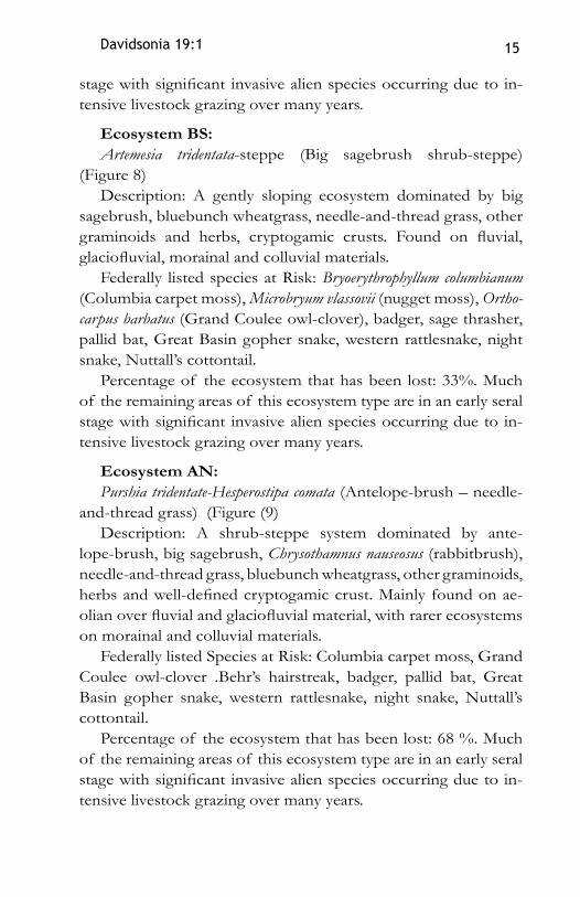
Ecosystem BS:Artemesia tridentata-steppe (Big sagebrush shrub-steppe)
(Figure 8)Description: A gently sloping ecosystem dominated by big
sagebrush, bluebunch wheatgrass, needle-and-thread grass, other graminoids and herbs, cryptogamic crusts. Found on fluvial, glaciofluvial, morainal and colluvial materials.
Federally listed species at Risk: Bryoerythrophyllum columbianum (Columbia carpet moss), Microbryum vlassovii (nugget moss), Ortho-carpus barbatus (Grand Coulee owl-clover), badger, sage thrasher, pallid bat, Great Basin gopher snake, western rattlesnake, night snake, Nuttall’s cottontail.
Percentage of the ecosystem that has been lost: 33%. Much of the remaining areas of this ecosystem type are in an early seral stage with significant invasive alien species occurring due to in-tensive livestock grazing over many years.
Ecosystem AN:Purshia tridentate-Hesperostipa comata (Antelope-brush – needle-
and-thread grass) (Figure (9)Description: A shrub-steppe system dominated by ante-
lope-brush, big sagebrush, Chrysothamnus nauseosus (rabbitbrush), needle-and-thread grass, bluebunch wheatgrass, other graminoids, herbs and well-defined cryptogamic crust. Mainly found on ae-olian over fluvial and glaciofluvial material, with rarer ecosystems on morainal and colluvial materials.
Federally listed Species at Risk: Columbia carpet moss, Grand Coulee owl-clover .Behr’s hairstreak, badger, pallid bat, Great Basin gopher snake, western rattlesnake, night snake, Nuttall’s cottontail.
Percentage of the ecosystem that has been lost: 68 %. Much of the remaining areas of this ecosystem type are in an early seral stage with significant invasive alien species occurring due to in-tensive livestock grazing over many years.

16
Figu
re 5
. M
aps s
how
ing
chan
ges i
n th
e Bl
ack
cotto
nwoo
d –
red-
osie
r dog
woo
d rip
aria
n fo
rest
(CD
) ec
osys
tem
bet
wee
n 18
00 a
nd 2
005.
1800
1938
2005

Davidsonia 19:1 17
Figu
re 6
. Map
s sho
win
g ch
ange
s in
the
Wat
er B
irch
– re
d-os
ier d
ogwo
od ri
paria
n sh
rub
swam
p w
etlan
d (B
D) e
cosy
stem
bet
wee
n 18
00 a
nd 2
005.
1800
1938
2005

18
Figu
re 7
. M
aps s
how
ing
chan
ges i
n th
e Id
aho
fesc
ue –
blu
ebun
ch w
heat
gras
s gra
ssla
nd (F
W) e
cosy
stem
bet
wee
n 18
00 a
nd 2
005.
1800
1938
2005

Davidsonia 19:1 19
Figu
re 8
. M
aps s
how
ing
chan
ges i
n th
e Bi
g sa
gebr
ush
shru
b-st
eppe
(BS)
eco
syst
em b
etw
een
1800
and
200
5.
1800
1938
2005

20
Figu
re 9
. M
aps s
how
ing
chan
ges i
n th
e A
ntel
ope-
brus
h –
need
le-a
nd-th
read
gra
ss sh
rub-
step
pe (A
N) e
cosy
stem
bet
wee
n 18
00 a
nd 2
005.
1800
1938
2005

Davidsonia 19:1 21
Table 1 Areal analysis for major ecosystem types for the Okanagan and Similkameen Valley study area.
Ecosystem 1800 ha 1938 ha 2003 ha
Percent Lost
Douglas-fir – pinegrass (gentle slope) (DP) 23,177 17,882 15,428 33
Ponderosa pine – bluebunch wheatgrass (gentle slope) (PW) 15,307 12,091 7767 50
Black cottonwood – Red-osier dog-wood floodplain, or lakeshore (CD)
7646 5167 3216 58
Water birch – Red-osier dogwood riparian wetland swamp (BD)
15,209 4497 1208 92
Okanagan River 212 212 15 93Cattail marsh (CT) 432 378 264 40Idaho fescue – Bluebunch wheatgrass grass steppe (FW) 19,528 8924 5017 75
Big sagebrush – needle-and-thread shrub-steppe (SN) 4366 3229 1335 70
Overall Big sagebrush shrub steppe (BS) 12,458 10,402 8266 33
Antelope-brush – needle-and-thread grass shrub-steppe (AN)
9895 7325 3178 68
Overall Gentle slope Grassland and Shrub-steppe 41881 26651 16461 61
Overall low elevation Wetlands (including marsh, shrub swamp, meadow, shallow open water)
17,786 6890 2965 84
City of Kelowna exampleAdditional but smaller areas within this larger study area were
analyzed for ecosystem loss, including the City of Kelowna, the City of Vernon, City of Penticton and the City of Summerland.
Results for the Kelowna area are provided in Table 2 for 5 eco-system types. Maps of the changes within the City of Kelowna are in Figure 10 (1800), Figure 11 (1938) and Figure 12 (2001).

22
Table 2 Areal analysis for major ecosystem types for the City of Kelowna
Shallow Open Water
(OW)
Ponderosa pine – blue-
bunch wheat-grass gentle slope (PW)
Idaho fescue –
bluebunch wheatgrass
(FW)
Water Birch
– red-osier dogwood wetland shrub
swamp (BD)
Black Cottonwood – red-osier dogwood
(CD)
2001hectares 32 1,211 246 117 188
1938hectares 155 3,061 858 498 558
1800hectares 171 4,510 3,653 3,084 1,287
Per-centage
Lost81 74 93 96 86
Percentage losses of certain ecosystem types were higher in the Kelowna area than for the whole of the Okanagan Valley. A similar analysis of the City of Vernon revealed that 100 percent of the Water birch – Red-osier dogwood shrub riparian unit was gone from this area.
Seral Community AnalysisSeral community analyses were done for the Idaho fescue
– bluebunch wheatgrass ecosystem, the Rough fescue – blue-bunch wheatgrass ecosystem, and for the Bluebunch wheatgrass – arrow-leaved balsamroot ecosystem from all of the present day Terrestrial Ecosystem Mapping (Bruhjell, et al 2000; Iverson et al 2004; Iverson and Shypitka, 2002; Iverson and Uunila, 2005, 2006; and, Iverson and Haney, 2006). The results in Tables 3, 4 and 5 show how livestock grazing has significantly affected the seral condition of grasslands in the Okanagan.

Davidsonia 19:1 23
Table 3 Seral analysis for the Idaho fescue – bluebunch wheatgrass ecosystem
Seral Stage Seral Association Name 1 Areal extent % of
Climax Idaho fescue – Bluebunch wheatgrass (climax) 410
Total Climax 410 ha 9
Mid to Late
$Bluebunch wheatgrass – Idaho fescue (wf) 104
$Idaho fescue - Cheatgrass (fc) 316$Columbian needlegrass – Balsamroot (nb) 22
$Big sagebrush – Bluebunch wheatgrass (sw) 156
$Bluebunch wheatgrass – knapweed (wk) 801Total Mid to Late 1399 ha 30
Mid $Big sagebrush – Columbia needlegrass (sn) 397
Total Early to Mid 397 ha 8
Early
$Cheatgrass – Columbia needlegrass (cn) 478$Columbia needlegrass - Cheatgrass (nc) 360$Big sagebrush – Kentucky bluegrass (sb) 73$Kentucky bluegrass (kb) 52
Total Early 963 ha 20
Early to Very Early
$Knapweed – cheatgrass (kc) 1459$Big sagebrush – Knapweed (sk) 67
Total Early to Very Early 1526 ha 32
Total All Seral Stages 4695 ha
1. The $ defines a seral plant community
Table 4 Seral analysis for the Rough fescue – bluebunch wheatgrass ecosystem
Seral Stage Seral Association Name1 Areal extent % of
Climax Rough fescue – bluebunch wheatgrass (climax) 2
Total Climax 2 ha 0.5Mid to Late $Bluebunch wheatgrass – knapweed (wk) 29

24
Total Mid to Late 29 ha 6
Early $Cheatgrass – Columbia needlegrass (cn) 8$Columbia needlegrass - Cheatgrass (nc) 7
Total Early 15 ha 3Early to Very Early $Knapweed – cheatgrass (kc) 457
Total Early to Very Early 457 ha 91
Total All Seral Stages 503 ha
1. The $ defines a seral plant community
Table 5 Seral analysis for the Bluebunch wheatgrass – arrow-leaved balsamroot ecosystem
Seral Stage Seral Association Name1 Areal extent % of
Climax Bluebunch wheatgrass – Arrow-leaved balsamroot 2128
Total Climax 2128 ha 34
Late $Big sagebrush – Bluebunch wheatgrass (sw) 330
Total Late 330 ha 5Mid to Late $Bluebunch wheatgrass – knapweed (wk) 2354Total Mid to Late 2354 ha 38
Mid $Big sagebrush – Columbia needlegrass (sn) 321
Total Mid 321 ha 5
Early to Mid $Knapweed – Cheatgrass – Bluebunch wheat grass (kw) 124
Total Early to Mid 124 ha 2
Early $Big sagebrush – Kentucky bluegrass (sb) 12$Kentucky bluegrass (kb) 5$Columbia needlegrass - Cheatgrass (nc) 34
Total Early 51 ha 1Early to Very Early $Knapweed – Cheatgrass (kc) 941
Total Early to Very Early 941 ha 15
Total All Seral Stages 6249 ha
1.The $ defines a seral plant community

Davidsonia 19:1 25
Range Condition AnalysisRange condition categories were mapped in the early 1990s
for the South Okanagan project area (Lea et al, 1998). These included Excellent, Good, Fair and Poor range condition classes following McLean (1978). This was done for four different eco-systems, the gentle sloped Antelope-brush – needle-and-thread gentle slope plant ecosystem, Big sagebrush – needle-and-thread plant ecosystem and Big sagebrush – bluebunch wheatgrass eco-system; and for the steeper slope Bluebunch wheatgrass – arrow-leaved balsamroot ecosystem on steeper slopes with warm as-pects. The results are shown in Table 6. Good Range Condition was combined with Excellent Range Condition in these results, as often it was difficult to separate these categories in the field. The other categories were easier to separate. The results show that the gentle slope ecosystems have much lower occurrence of Good to Excellent Range Condition, and that the steeper slope ecosystem has a very high occurrence of Good to Excellent Range Condi-tion, demonstrating clearly the significant impact of concentrated livestock use on the gentle slope ecosystems in the study area.
Table 6 Range Condition for selected ecosystem typesPercentage
Good to Excellent
Range Condition
Percentage Fair Range Condition
Percentage Poor
Range Condition
Antelope-brush – needle-and-thread grass gentle slope 5 26 69
Big sagebrush - needle-and-thread grass gentle slope 2 39 59
Big sagebrush- bluebunch wheatgrass gentle slope 20 61 19
Bluebunch wheatgrass – arrow-leaved balsamroot steep slope, warm aspect
68 27 25

26
DiscussionThis study has shown that loss of ecosystems in the developed
portion of the Okanagan has been substantial, with many lower elevation ecosystem types having lost over 60 percent of their original area, and a few reduced by more than 90 percent of their area. As well, seral community and range condition analysis of the remaining natural areas shows that there has been significant alteration of these communities, mainly by livestock grazing. The combination of ecosystem loss, fragmentation and degrada-tion has had substantial impacts on local biodiversity and abil-ity for species to exist, evolve, or to migrate to other areas. In many cases these options will not exist in the future with climate change, particularly for species that can only move on the ground or short distances at a time.
It is important to know the original conditions of ecosystems before restoration is attempted (MacDougall et al. 2004). Histor-ical mapping generally only gives one point in time and usually does not describe the detailed plant composition of communities that existed 150 to 200 years ago. To determine plant compos-
LEGEND TO OKANAGAN MAPFigure 10
ition one must look at the remnants that still exist on the landscape. Successional changes over time can con-found what one might have expected in historical situa-tions.
There is some uncertainty about the earlier existence of smaller wetlands or vernal pools in the landscape, as much of the gentle slop-ing grassland had already been converted to agricul-tural uses when the 1938 air photographs were taken.

Davidsonia 19:1 27
Figure 10. Terrestrial Ecosystem Mapping - City of Kelowna 1800.
Historical ecosystem mapping by Ted Lea, BC Ministry of EnvironmentFunding from Canadian Wildlife Service, BC Ministry of Environment, BC Integrated Land Management Bureau, and the Committee on the Status of Endangered Wildlife in Canada (COSEWIC).Photo transfer by Lyle Ottenbreit, VISION -L GraphicsGIS work by Joe Boyd, Trackside Consulting Inc.

28
Figure 11. Terrestrial Ecosystem Mapping - City of Kelowna 1938.
Historical ecosystem mapping by Ted Lea, BC Ministry of EnvironmentFunding from Canadian Wildlife Service, BC Ministry of Environment, BC Integrated Land Management Bureau, and the Committee on the Status of Endangered Wildlife in Canada (COSEWIC).Photo transfer by Lyle Ottenbreit, VISION -L GraphicsGIS work by Joe Boyd, Trackside Consulting Inc.

Davidsonia 19:1 29
wetland types that no longer exist. Many such areas had been de-veloped by human activity before the 1938 air photographs were taken. Structural and successional stages were not included in the historical maps, as it was not possible to verify the plant com-munities that exist at the time.
Information about forested conditions and structural stages for forests and grasslands was not essential for determining eco-system loss. Comparisons of air photographs from 1938 and orthophotos of the same areas taken in 2001 made it obvious that substantial forest encroachment occurred during this period. Analysis of seral communities and range condition using pres-ent day terrestrial ecosystem maps provided an understanding of which grassland and shrub/steppe ecosystems have been signifi-cantly affected by livestock grazing.
Value of Mapping Historical EcosystemsThere are several potential uses of ecosystem mapping and
analysis including comparisons of historical ecosystems with present day ecosystem information including (from Egan and
LEGEND TO OKANAGAN MAPFigure 11
This could have led to under or over estimation of grass-lands areas. However, there were clues in surrounding natural areas and often ref-erence ecosystems were still present and provided some grounds to validate extrapo-lation and to map these eco-systems. Similarly, shrub ri-parian areas of water birch and red-osier dogwood com-munities may have contained small areas of wetlands, shal-low open water, and cattail marshes, and possibly other

30
Figure 12. Terrestrial Ecosystem Mapping - City of Kelowna 2001.
Historical ecosystem mapping by Ted Lea, BC Ministry of EnvironmentFunding from Canadian Wildlife Service, BC Ministry of Environment, BC Integrated Land Management Bureau, and the Committee on the Status of Endangered Wildlife in Canada (COSEWIC).Photo transfer by Lyle Ottenbreit, VISION -L GraphicsGIS work by Joe Boyd, Trackside Consulting Inc.

Davidsonia 19:1 31
species at risk. Preservation and stewardship of the remaining pieces will be required to maintain these species at risk.
to support requests for sustainable habitat protection/sustainable development by clearly demonstrating unsustain-able practices;
to quantify reasons for habitat loss when combined with current mapping (ie x% due to agriculture (or even types of agriculture); x% to urban, etc.);
to quantify threats to habitat and aids in target threat re-duction efforts;
to determine loss of habitat for species at risk.to determine habitat value for species at risk – present
potential, capability, and potential critical habitat.to stratify inventory for species at risk (the author was re-
quested to provide information on locations of alkaline ponds from the ecosystem mapping to aid with inventory for the dark saltflat tiger beetle Cicindela parowana subsp. wallisi).
●
●
●
●●
●
LEGEND TO OKANAGAN MAPFigure 12
Howell 2001 and Dyer, O.N., Pers. Comm. 2007):
a dramatic visual display to demonstrate extent of ecosystem loss which can be shown to local and regional govern-ment and developers, as well as to the public;
to demonstrate the importance of the re-maining areas of a par-ticular ecosystem, espe-cially in ecosystems which contain large numbers of
●
●

32
to prioritize habitats for conservation based on import-ance for species and how much has been lost.
to map loss of ecosystems aids in the development of species Status Reports for assigning trends in habitat – (This mapping has been used for Status Reports for sooty hair-streak, Rocky Mountain ridged mussel, Nuttall’s cottontail, yellow-breasted chat, Behr’s hairstreak, Mormon metalmark, sage thrasher, and sage grouse).
for restoration of habitats – e.g. riparian areas that were channelized, identifying what is capable of being restored, where restoration is most cost effective or probable (in com-bination with current maps and ownership).
to point out the importance of remaining pieces – what is lost compared with targets for functional ecosystem con-servation on a landscape scale. In a detailed study of the min-imal area needed to retain current estimated population levels of 29 target vertebrates in the SOSCP area, using TEM data, Warman (2001) showed that 44% of the area is needed to be maintained as high class conservation habitat. This is a min-imal area estimate and did not provide for buffer zones, con-nectivity, corridors, natural disturbance regimes (such as fire) and climate change.
to improve understanding of regional heritage and how humans have affected ecosystems.
to show that ecosystems can be completely or mostly lost, caused by humans.
Several very important issues require immediate attention:
The lands that we need to conserve to maintain species and species-at-risk are those that include the ecosystems that support them. Many such ecosystems are themselves at risk
It is time to focus more effort on the ecosystems or we won’t be able to maintain many of the species presently at risk and many more species will be added to the at risk lists
●
●
●
●
●
●
●
●

Davidsonia 19:1 33
There is a strong need for ecosystems at risk legislation that parallels the legislation for species at risk that is already in place federally and provincially.
Acknowledgements Special appreciation goes to Orville Dyer, Dave Fraser, Jan
Kirkby, Carmen Cadrin and Susan Latimer for encouragement throughout the mapping project. Special thanks to Lyle Otten-briet of Vision-L Graphics for air photo transfer and Joe Boyd of Trackside Consulting Inc. for GIS analysis. Funding was pro-vided by the Committee on the Status of Endangered Wildlife in Canada (COSEWIC), Canadian Wildlife Service of Environ-ment Canada, the B.C. Integrated Land Management Bureau and the B.C. Ministry of Environment. Acknowledgement goes to Marco Festa-Bianchet of COSEWIC, Trish Hayes of the Can-adian Wildlife Service, Marta Donovan, Jenifer Penny, Deepa Filatow, Jenny Feick and Seán Sharpe of the B.C. Ministry of Environment, Bob Nicholson, Carol Ogborne, Jamie Duncan, Larry Lohr, Ron Johnson, Mark Poire of the Integrated Land Management Bureau, Aaron Fujikawa, GISsolutions Inc., Ken Ellison of the Vernon Archives, and Calvin Woelke of the Land Title and Survey Authority of BC. Thanks to Brenda Costanzo, Lora Lea and an anonymous individual for reviewing drafts of this paper, and to Iain E.P. Taylor and Eric La Fountaine for final production of the paper.
ReferencesB.C. Ministry of Environment, Lands and Parks. 1998. Habitat atlas for wild-
life at risk: south Okanagan and lower Similkameen. Victoria: Queen’s Printer.
Blackstock, M.D. and McAllister, R. 2004. First Nations perspectives on the grasslands of the interior of British Columbia. Journal of Ecological Anthropology 8: 24-46.

34
Bruhjell, D.R., Robertson, S., Vujnovic, K., Saxena, A., and Bentz, J.A. 2000. Terrestrial ecosystem mapping with wildlife interpretations for Weyer-haeuser TFL 15. Volume 1: Terrestrial ecosystem mapping with expanded legends for terrestrial ecosystems units. Prepared for Weyerhaeuser Canada Ltd. Okanagan Falls, B.C. Collett, A. and Uunila, P. 2005. Okanagan ter-rain mapping, Kelowna, Vernon and Peachland areas. Timberline Forest Inventory Consultants Ltd and Polar Geoscience. Prepared for the B.C. Ministry of Water, Land and Air Protection, Penticton, B.C.
Ecosystems Working Group. 1998. Standard for Terrestrial Ecosystem Map-ping in British Columbia. Victoria: Terrestrial Ecosystems Task Force, Resources Inventory Committee.
Egan, D. and Howell, E.A. (Editors). 2001. The Historical Ecology Handbook: A Restorationist’s Guide to Reference Ecosystems. Washington, D.C.: Island Press, 2001.
Hebda, R.J. 1982. Postglacial history of grasslands of southern British Colum-bia and adjacent regions. In Grassland Ecology and Classification Sympo-sium Proceedings. Edited by A.C. Nicholson, A. McLean, and T.E. Baker. Victoria: BC Ministry of Forests. pp. 157-191.
ICBEMP, 2007. Interior Columbia Basin Ecosystem Management Project Website: http://www.icbemp.gov/ (Accessed August 2007)
Iverson, K., Cadrin, C., Spaeth Filatow, D. and Erwin, C. 2004. Sensitive eco-systems inventory: Central Okanagan, 2000 - 2001. Volume 2: Terres-trial ecosystem mapping, surface erosion and slope stability, and expanded legend. Victoria: BC Ministry of Environment.
Iverson, K. and Shypitka, J. 2002. Sensitive ecosystems inventory: Bella Vista – Goose Lake Range 2002. Volume 2: Terrestrial ecosystem mapping, soil erosion and slope stability and expanded legend. Victoria: BC Ministry of Environment.
Iverson, K. and Uunila, P. 2005. Sensitive ecosystems inventory: Vernon Com-monage, 2005. Volume 2: Terrestrial ecosystem mapping, terrain map-ping and expanded legend. Victoria, BC Ministry of Environment.
Iverson, K. and Uunila, P. 2006. Sensitive ecosystems inventory: Lake Coun-try, 2005. Volume 2: Terrestrial ecosystem, terrain, terrain stability and surface erosion mapping and expanded legend. Victoria, BC Ministry of Environment.
Iverson, K. and Uunila, P. 2008. Sensitive Ecosystems Inventory: Vernon, Cold-stream and Kalamalka, 2007. Volume 2: Terrestrial Ecosystem, Terrain,

Davidsonia 19:1 35
Terrain Stability, and Erosion Potential Mapping, and Expanded Legend. Victoria: BC Ministry of Environment.
Iverson, K and Haney, A. 2006. Updated ecosystem mapping for the south Okanagan Valley. Victoria: BC Ministry of Water, Land and Air Protec-tion.
Iverson, K. and Fleming, T. 2008. Sensitive ecosystems inventory - Okanagan Valley: Vernon to Osoyoos, 2000 - 2007. Methods, Ecological Descrip-tions, Results and Conservation Tools. Technical Report Series, Canadian Wildlife Service, Pacific and Yukon Region, British Columbia.
Lea, E.C., Maxwell, R.E., and Swanson A. 1998. Biophysical Habitat Units of the South Okanagan Study Area. Victoria: Resources Inventory Branch, British Columbia Ministry of Environment, Lands and Parks.
Lloyd, D., Angove, K., Hope, G., and Thompson C. 1990. A guide to site iden-tification and interpretation for the Kamloops Forest Region. Kamloops: BC Ministry of Forests.
McLean, A. 1978. Range management handbook for British Columbia. Kam-loops: Agriculture Canada.
MOELP, 1998. Habitat atlas for wildlife at risk: south Okanagan and lower Similkameen. Victoria: BC Ministry of Environment, Lands and Parks.
Noss, R.F., LaRoe III, E.T., and Scott, J.M. 1995. Endangered ecosystems of the United States: a preliminary assessment of loss and degradation. U.S. National Biological Service. Biological Report 28.
Peters, R., and Noss, R. 1995. America’s endangered ecosystems. Defenders of Wildlife,Washington, D.C. Available from www.defenders.org (accessed April 2004).
Rich, T.D. 1996. Degradation of shrubsteppe vegetation by cheatgrass inva-sion and livestock grazing: effect on breeding birds. Abstract only. Colum-bia Basin Shrubsteppe Symposium. April 23-25, 1996. Spokane, WA.
Tisdale, E.W. 1982. Grasslands of western North America: The Pacific North-west Bunchgrass. In Grassland Ecology and Classification, Symposium Proceedings, Edited by A.C. Nicholson, A. McLean, and T.E. Baker. Vic-toria: BC Ministry of Forests. pp. 223-245.
Warman, L. 2001. Identifying priority conservation areas using systematic re-serve selection and GIS at a fine spatial scale: a test case using threatened vertebrate species in the Okanagan, British Columbia. M.Sc. Thesis, De-partment of Zoology, University of British Columbia, Vancouver, BC. 175pp.