Embed Size (px)
Citation preview
Historical Ethnography and Archaeology of RussianFort Elisabeth State Historical Park, Waimea, Kaua'i
PeterR MillsDepartment ofAnthropology, University ofVermont
IntroductionThere is a sign on the highway in Waimea, Kaua'i in the Hawaiian Islands with the
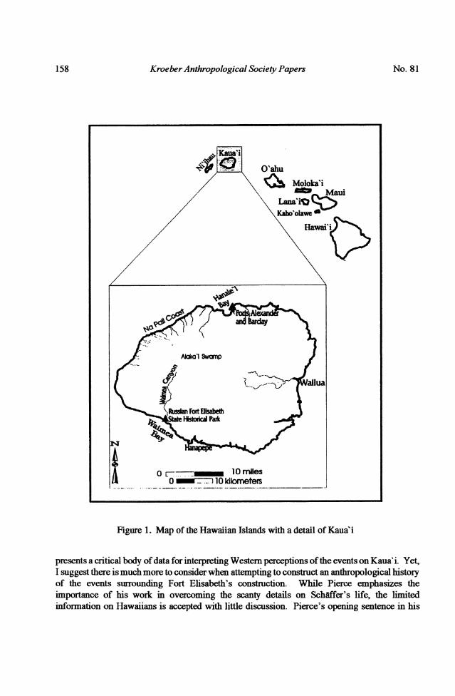
words "Russian Fort" printed on it. Local residents use the same term to refer to the StateHistorical Park that the sign marks. I give this introduction not because it is the best, but becauseit is the one that everyone else gets. Fort Elisabeth was built in Waimea, Kaua' i following analliance between Kaumuali'i, paramount chief of Kaua'i, and Georg Anton Schiffer of theRussian-American Company (RAC) in 1816. Georg Schaffer and the RAC were forced to leaveKaua'i in 1817 which left Kaumuali'i in sole control of the fort. Most tourists visiting the siteare surprised to fmd that Russians were building forts in the Hawaiian Islands, but the story ofFort Elisabeth and two smaller forts (Alexander and Barclay) on the north shore of Kaua'i(Figure 1) has been "well-tilled" (Barratt 1988:v) for over a century (Alexander 1894; Barratt1988:15-24; Bolkhovitinov 1973; Bradley 1942; Emerson 1900; Golder 1930; Gronski 1928;Jarves 1844:201-203; Mazour 1937; Mehnert 1939: 22-65; Okun 1951; Pierce 1965; Tumarkin1964:134-166; Whitney 1838:48-51).
On Kaua'i, Fort Elisabeth seems to be perceived as a cumbersome and obscuremonument to 19th century European expansion, lacking in any connection to traditionalHawaiian landscapes. Within the academic community, little recent attention focuses on the fortother than Richard Pierce's Russia's Hawaiian Adventure 1815-1817 (1965) with a follow-uparticle by Bolkhovitinov (1973). As Pierce's title suggests, historical interest in the fort centerson the brief Russian-American Company presence. Some of the historical discussions beginwith the first Russian expedition to the Hawaiian Islands in 1804 led by Krusenstem andLisianskii on the Nadezhda and Neva respectively (see Barratt 1987) and generally follow thehistory of the Russian fur trade. When discussions of Hawaiian history are included, they aregiven as brief introductions to the arrival of the RAC in Hawaii. Thus, by emphasizing thepolitical history and economic motivation of the RAC, Russians are presented as the actors andHawaiians usually are presented as part of the set. Nikolai Bolkhovitinov (1973:56) goes so faras to ask the following:
Is there a need for retuming once again to a study of this subject? Would thisnot simply be a repetition offacts already known, and do any sort ofdisputableproblems remain in general? Even a brief examination of the historiographywould show that we cannot harbor any special hopes of disclosing principallynew documents and facts.
Bolkhovitinov does fimd cause to return to the subject, but it is for the purpose of bettersynthesizing some of the primary Russian historical accounts. Richard Pierce's work (1965) isa thorough and scholarly compilation of historical documents written by RAC employees; it
KroeberAnthropological Society Papers
0 [- I 0 miles0 _ T10 kilometers
Figure 1. Map of the Hawaiian Islands with a detail of Kaua'i
presents a critical body ofdata for interpreting Western perceptions ofthe events on Kaua' i. Yet,I suggest there is much more to considerwhen attempting to construct an anthropological historyof the events surrounding Fort Elisabeth's construction. While Pierce emphasizes theimportance of his work in overcoming the scanty details on Schaffer's life, the limitedinformation on Hawaiians is accepted with little discussion. Pierce's opening sentence in his
158 No. 81

Archaeology ofRussian Fort Elisabeth State HistoricalPark
introduction states "The Pacific Ocean, all but empty of sail until Cook's epoch-making voyagesin the 1770s, became in little more than a generation the scene of a thriving and far-flungcommerce"(Pierce 1965:1). While inter-island commerce certainly increased in the Pacificfollowing the anrival of Cook, the statement "all but empty of sail" is particularly unsuited forPolynesia. It creates a false sense of emptiness in an area with a rich history of colonization,exchange, and sociopolitical intensification and consequently subordinates Hawaiians in theevents of the 19th century.
Ethnohistorians are re-evaluating historical events from broader perspectives (Biersack1990; Dening 1988; Linnekin 1990; Sahlins 1981,1985; Valeri 1985, 1990). Their researchemphasizes that different cultures usually perceive the same events differently and oftenparticipate in new events through creative adaptations of historical tradition. Employing thesebasic postulates, I re-examine Russian Fort Elisabeth to understand a broader history behind this19th century monument. In addition to conducting historical ethnography, I incorporate datafrom archaeological excavations into a new narrative of Fort Elisabeth. The combination ofthese two approaches challenges Bolkhovitinov's statement that "we cannot harbor any specialhopes of disclosing principally new documents and facts."
Hawaii in the World SystemWhen Captain Cook's expedition first discovered the Hawaiian Islands in 1778, they
landed at Waimea, Kaua'i and found people living in a highly stratified socio-political system.Chiefs ruled entire islands and frequently fought for control ofneighboring islands. Their statuswas based upon a deified heredity ranking system as well as secular political power. FollowingCaptain Cook's arrival, their political system began to closely mimic the British monarchy bygiving the paramount rulers the titles of "King" and "Queen" (Vancouver 1984:474). Hawaiiansentered into the global economy, or what Wallerstein (1974, 1980) called the "World System,"in a way that is not typical of concepts of the "periphery" in World Systems theory. Hawaiianchiefs controlled large amounts of resources, particularly provisions for ships, and in the early1 800s Hawaiian sandalwood was a valuable commodity in Canton. The chiefs exploited theircontrol of these resources to increase their wealth and status (Sahlins 1992:37-81). In theprocess, they acquired substantial stockpiles of foreign wealth including hard currency, ships,and large supplies of munitions. They also benefited from competition between various foreignpowers. In April of 1791, the Princess Royal under Spanish command was in Waimea Bay,Kaua'i at the same time that the British ship Argonaut under Capt. James Colnett was in thevicinity. Colnett recorded the following in his log:
I wanted nothing from Atooi [Kaua' i], but had sent them, in case of the Span-iards coming to settle there, powder, shot, arms, and ammunition, and a num-ber of other presents for the Chiefs, their wives, daughters, and children, ourold and worthy friends. I also left here my remaining livestock consisting ofa ram and two ewes, a cock and two hen turkeys, withbeans, peas, indian corn,and Callavances (Colnett 1940:222).It is important to recognize that while foreign people, concepts, and goods entered
Hawaii, the process was not a passive one for the Hawaiians. Hawaiian culture was changing,but a changing culture should not necessarily be viewed as passive, subordinated, or weakened.
Mills 159
KroeberAnthropological Society Papers
By controlling the resources that were needed by all merchants, Hawaiian elites took fulladvantage of their position. They convinced foreign craftpersons to work for them includingblacksmiths, carpenters, and sail-makers so that they did not have to depend upon trade for manystatus goods that could be produced locally (Campbell 1822:99-100; Sahlins 1992:43). In short,Hawaiian culture was transforming in the late 18th century and early 19th century in such a way
that the wealth of Hawaiian chiefs was increasing in a fundamentally indigenous socio-politicalsystem, and the ability of foreigners to acquire goods and provisions at cheap prices was
decreasing.
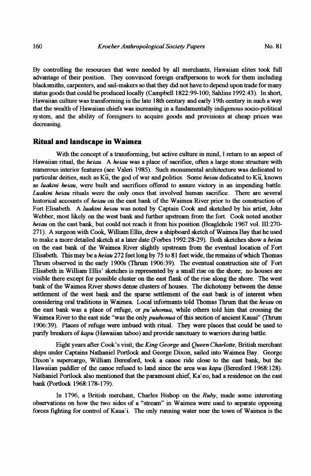
Ritual and landscape in WaimeaWith the concept of a transfonning, but active culture in mind, I return to an aspect of
Hawaiian ritual, the heiau. A heiau was a place of sacrifice, often a large stone structure withnumerous interior features (see Valeri 1985). Such monumental architecture was dedicated toparticular deities, such as Ku, the god of war and politics. Some heiau dedicated to Ku, knownas luakini heiau, were built and sacrifices offered to assure victory in an impending battle.Luakini heiau rituals were the only ones that involved human sacrifice. There are severalhistorical accounts of heiau on the east bank of the Waimea River prior to the construction ofFort Elisabeth. A luakini heiau was noted by Captain Cook and sketched by his artist, JohnWebber, most likely on the west bank and further upstream from the fort. Cook noted anotherheiau on the east bank, but could not reach it from his position (Beaglehole 1967 vol.III:270-271). A surgeon with Cook, William Ellis, drew a shipboard sketch of Waimea Bay that he usedto make a more detailed sketch at a later date (Forbes 1992:28-29). Both sketches show a heiauon the east bank of the Waimea River slightly upstream from the eventual location of FortElisabeth. This may be a heiau 272 feet long by 75 to 81 feet wide, the remains of whichThomasThrum observed in the early 1900s (Thrum 1906:39). The eventual construction site of FortElisabeth in William Ellis' sketches is represented by a small rise on the shore; no houses are
visible there except for possible cluster on the east flank of the rise along the shore. The westbank of the Waimea River shows dense clusters of houses. The dichotomy between the densesettlement of the west bank and the sparse settlement of the east bank is of interest whenconsidering oral traditions in Waimea. Local infonnants told Thomas Thrum that the heiau on
the east bank was a place of refuge, or pu'uhonua, while others told him that crossing theWaimea River to the east side "was the only puuhonua of this section of ancient Kauai" (Thrum1906:39). Places of refuge were imbued with ritual. They were places that could be used topurify breakers of kapu (Hawaiian taboo) and provide sanctuary to warriors during battle.
Eight years after Cook's visit, the King George and Queen Charlotte, British merchantships under Captains Nathaniel Portlock and George Dixon, sailed into Waimea Bay. GeorgeDixon's supercargo, William Beresford, took a canoe ride close to the east bank, but theHawaiian paddler of the canoe refused to land since the area was kapu (Beresford 1968:128).Nathaniel Portlock also mentioned that the paramount chief, Ka'eo, had a residence on the eastbank (Portlock 1968:178-179).
In 1796, a British merchant, Charles Bishop on the Ruby, made some interestingobservations on how the two sides of a "stream" in Waimea were used to separate opposing
forces fighting for control of Kaua'i. The onlyrunning water near the town of Waimea is the
160 No. 81
Archaeology ofRussian Fort Elisabeth State Historical Park
Waimea River, so I assume that the "stream" refers to the river. Bishop's account is providedbelow:
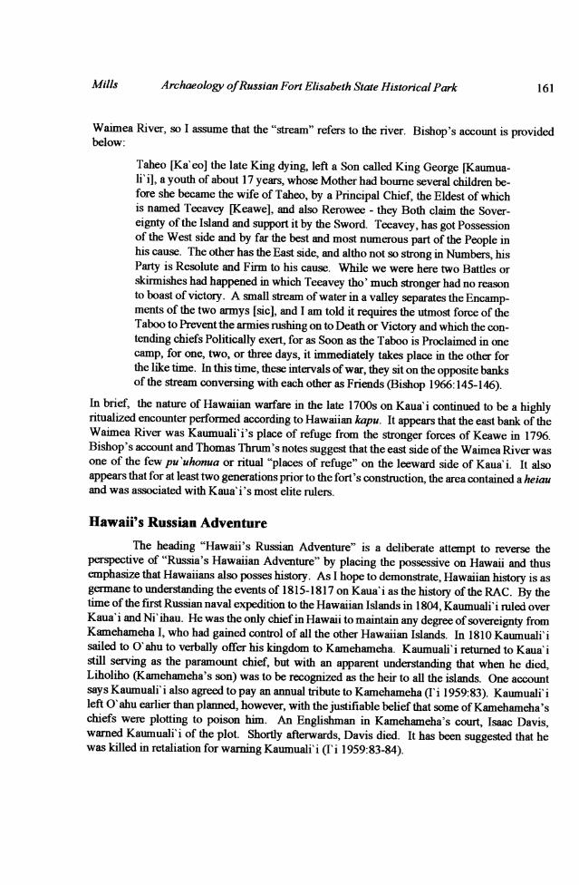
Taheo rKa'eo] the late King dying, left a Son called King George [Kaumua-li' i], a youth of about 17 years, whose Mother had bourne several children be-fore she became the wife of Taheo, by a Principal Chief, the Eldest of whichis named Teeavey [Keawe], and also Rerowee - they Both claim the Sover-eignty of the Island and support it by the Sword. Teeavey, has got Possessionof the West side and by far the best and most numerous part of the People inhis cause. The other has the East side, and altho not so strong in Numbers, hisParty is Resolute and Firm to his cause. While we were here two Battles orskirmishes had happened in which Teeavey tho' much stronger had no reasonto boast of victory. A small stream ofwater in a valley separates the Encamp-ments of the two armys [sic], and I am told it requires the utmost force of theTaboo to Prevent the armies rushing on to Death or Victory and which the con-tending chiefs Politically exert, for as Soon as the Taboo is Proclaimed in onecamp, for one, two, or three days, it immediately takes place in the other forthe like time. In this time, these intervals ofwar, they sit on the opposite banksof the stream conversing with each other as Friends (Bishop 1966:145-146).
In brief, the nature of Hawaiian warfare in the late 1700s on Kaua'i continued to be a highlyritualized encounter performed according to Hawaiian kapu. It appears that the east bank of theWaimea River was Kaumuali'i's place of refuge from the stronger forces of Keawe in 1796.Bishop's account and Thomas Thrum's notes suggest that the east side ofthe Waimea River wasone of the few pu 'uhonua or ritual "places of refuge" on the leeward side of Kaua'i. It alsoappears that for at least two generations prior to the fort's construction, the area contained a heiauand was associated with Kaua'i's most elite rulers.
Hawaii's Russian AdventureThe heading "Hawaii's Russian Adventure" is a deliberate attempt to reverse the
perspective of "Russia's Hawaiian Adventure" by placing the possessive on Hawaii and thusemphasize that Hawaiians also posses history. As I hope to demonstrate, Hawaiian history is asgermane to understanding the events of 1815-1817 on Kaua'i as the history of the RAC. By thetime of the fu-st Russian naval expedition to the Hawaiian Islands in 1804, Kaumuali'i ruled overKaua'i and Ni'ihau. He was the only chief in Hawaii to maintain any degree of sovereignty fromKamehameha I, who had gained control of all the other Hawaiian Islands. In 1810 Kaumuali'isailed to 0' ahu to verbally offer his kingdom to Kamehameha. Kaumuali' i returned to Kaua' istill serving as the paramount chief, but with an apparent understanding that when he died,Liholiho (Kamehameha's son) was to be recognized as the heir to all the islands. One accountsays Kaumuali'i also agreed to pay an annual tribute to Kamehameha (I'i 1959:83). Kaumuali'ileft 0' ahu earlier than planned, however, with the justifiable belief that some ofKamehameha'schiefs were plotting to poison him. An Englishman in Kamehameha's court, Isaac Davis,warned Kaumuali' i of the plot. Shortly afterwards, Davis died. It has been suggested that hewas killed in retaliation for warning Kaumuali'i (I'i 1959:83-84).
mills
KroeberAnthropological Society Papers
Regardless of the tentative nature of this political situation, 1810 is often cited as thedate of the final unification of the Hawaiian Islands under one Hawaiian sovereign. MarshallSahlins recent introduction to the historical ethnography of Anahulu Valley is typical of theportrayal of a unifled kingdom in 1810: "Only now, by virtue ofthe new means ofpower [foreigntrade], it became possible for one chief, Kamehameha of Hawai' i Island, to realize the objectiveof a unified kingdom" (Sahlins 1992:3).
The premise of a unified Hawaiian kingdom after 1810 has a secondary effect on theinterpretation of the events of 1816 and 1817 on Kaua'i. It implies that the political tensionbetween Kamehameha and Kaumuali'i during the RAC presence on Kaua'i was primarily theresult of an imperialistic agenda of Georg Schaffer. This premise is also supported by astatement attributed to Kamehameha in 1817 by a Russian Naval Officer, Otto Von Kotzebue:
But what was the consequence of my hospitality? Even before he [Schaffer]left Owhyee [Hawai'i Island], he repaid my kindness with ingratitude, whichI bore patiently. Upon this, according to his own desire, he traveled from oneisland to another; and, at last, settled in the fruitful island of Woahoo [O' ahu],where he proved himself to be my most inveterate enemy; destroying our sanc-tuary, the Morai [heiau]; and exciting against me, in the island of Atooi[Kaua'i], King Tamary [Kaumuali'i], who had submitted to my power yearsbefore. Sheffer is there at this very moment, and threatens my islands (Kotze-bue 1967:304).
If this quote is an accurate representation of Kamehameha's words, Kamehameha clearlyportrayed Schaiffer as the initiator of change. I suggest, however, that this account cannot betaken at face value. Kamehameha had much to gain by portraying Schiffer as the initiator of arebellion on Kaua' i. In so doing, the Russians were responsible for destroying peace in a unifiedkingdom. Kamehameha thereby placed a diplomatic responsibility on Kotzebue to restorepeace.
Another possibility is that Kotzebue fabricated the idea that Schaiffer excitedKaumuali'i against Kamehameha. In 1817, the Russian Navy and the RAC were at odds witheach other over the management ofthe RAC (Chevigny 1965:162). While the Navy gained littleby openly undermining the efforts of the RAC, they had their own agenda of proving that theRAC was poorly run under pnrvate management and should be taken over by the Navy. Bymaking Schiffer the destroyer of peace, Kotzebue justifled his lack of action in support ofSchiffer.
The general acceptance of a unified kingdom after 1810 fails to recognize the nature ofthe political tensions and economic competition between Kaumuali'i and Kamehameha. Forexample, the American merchants Jonathan Winship Jr., Nathan Winship, and William HeathDavis signed a contract with Kamehameha in 1812 to procure sandalwood in his domain (Phelpsn.d.:63-65). This contract, however, did not cover Kaumuali'i's territory, where a separatecontract was drawn up with Kaumuali'i for Kaua'i and Ni'ihau (Phelps n.d.:68).
More conclusive documentation of the lack of unification after 1810 comes from a logkept by an American resident in Waimea, Kauai in 1814 and 1815 (Anonymous, "Log of theAtahualpa," n.d.). Only the last portion of this log from January to April of 1815 has been
No. 81162
Archaeology ofRussian Fort Elisabeth State Historical Park
published (Howay 1933). The following entiy at Waimea, Kaua'i is dated Friday, March 18,1814:
...At 9am arrived the Ships Isabella [and] Pennsylvania Packet[,] Capt[ains]Davis & Meek, last from Woahoo [O'ahu]. Capt. D. informed us that Tama-hamaah [Kamehameha], King of the Windward Islands was making everypreparation for invading this Island[.] As of late Tamaree [Kaumuali' i], Kingof this place has refused paying him a Tribute which was granted him by theKing at the last settlement ofNational affairs which was concluded through theintercession of Mr. Thos. Robinson, in 1810.
Thus, Kaumuali'i had committed to breaking his tenuous ties with Kamehameha well before1815 when "Russia's Hawaiian Adventure" began. During the War of 1812 Kaumnuali' i solicitedAmerican merchants to live and store their supplies on Kaua' i as safe haven from the British.The following entry dated April 1, 1814 from the same log demonstrates how the Americanswere drawn into a role of protecting Kaumuali'i's kingdom:
This day a council of war was held at the House (at which all the nobility at-tended) for the purpose of adopting some effectual means, for the present &Future safety of this Island from the invasion of Tamahamaah King of Owhy-hee [Hawai' i Island]. The plan adopted was to send all the men from this Is-land which belonged to the Windward Islands & to keep themselves inconstant readiness for defence. Capts. Davis, Winship & Whittemore at thesame time proffered their friendship & protection as far as lay in their powers,at all times. Thinking it not only requisite for the safety of their property, butJustice to Tamaree, the King for his friendly disposition & protection forAmericans.
The log goes on to describe the removal ofpeople with affiliations to Kamehameha from Kaua' i,the parading of idols through the town of Waimea, and on September 16, 1814, a human sacri-fice:
About 12 O'Clock at night was heard the screaching of some native & in themoming we were informed that it came from a man as they draged [sic] himto the Morai [heiau] & sacrificed him to their Idols.
These events are important to understanding "Russia's Hawaiian Adventure" because all previ-ous histories suggest that it was the arrival ofthe scheming and ambitious Georg Schiiffer in 1816that prompted Kaumuali'i to rebel against Kamehameha. Such an erroneous perspective pre-sents the Russians as the initiators of change, and relegates Kaumuali'i to the role of a "dupe"(Emerson 1900:17). The long term perspective is that Kaumuali'i constantly sought to alignhimself with any foreign power that would assist him in maintaining his sovereignty from Ka-mehameha.
The log of the Atahualpa repeatedly suggests that Kaumuali' i was losing the support ofthe Kaua'i Islanders during 1814, possibly due to the heavy demand for labor in the harvestingof sandalwood. Another chief, alternately referred to in the "Log of the Atahualpa" as"Tamahaw-ra-ran-nu," or "Tamahawnalany" [Kamaholelani] was Kaumuali'i's kalaimoku, or"prime minister." The writer ofthe log thought that this chiefwas about to take control ofKaua'i
mills 163
Kroeber Anthropological Society Papers
from Kaumuali'i. As the War of 1812 was coming to a close in late 1814, the resident Americanmerchants mostly left Kaua'i, leaving Kaumuali'i short of supplies, ships, and munitions.Furthermore, Kaumuali' i refused to deliver any more sandalwood to the American merchants,mostlikely to quell his developing unpopularity among his subjects. William H. Davis and theWinship brothers left Waimea with their contract unfulfilled only after Davis threatenedbombardment of the town from his ship(Log of the Atahualpa, September 26, 1814 - October 1,1814).
With Kaumuali'i's commitment to separating from Kamehameha and his falling-outwith the American merchants, he probably was looking for another foreign power to alignhimself with. It was in these political and economic conditions that the RAC ship Beringwrecked in Waimea on January 31, 1815 with a valuable cargo of furs. Captain James Bennett,who was contracted by the RAC, asked Kaumuali'i for assistance in recovering the cargo:
Capt. Bennett waited on the King and requested his immediate assistance insaving the cargo; to which he would comply, provided Capt. B. would givehim the ship as she lay and not otherwise, which was thought most expedientas it was evident that she could not be got off (Howay 1933:76).
By February 3, 1815, two-thousand Hawaiians gathered to partake in the salvage (Howay1933:77) with personal provisions from the ship being taken to Kaumuali' i's house. The follow-ing day, the entry in the log of the Atahualpa states:
This day the King requested all the crew to assemble at his house for the pur-pose of obtaining their chests. The King proposed to retain one half of eachman's clothes, to satisfy him for his taking them under his charge. We, oneand all, replied that ifhe retained one piece, we would not receive any ofthem,but get satisfaction at some future day. From observation we have great reasonto fear that the King will not grant us even the necessaries for our living, as heis sensible that we are in his power and he will do with us as he pleases.
Captain Bennett, an American, had little political authority to represent either American or Rus-sian interests and it seems that Bennett and his crew were treated with little respect, with the crewbeing tossed off the wrecked ship and into the water shortly after the wreck. The log had earlierrecorded that even a king's house would be "plundered" after a fire (Log of the Atahualpa, May27, 1814), and a similar action was taken by Hawaiians after a shipwreck off of Maui in April of
1814 (Porter 1822:208). Tikmenev (1978:121) also recorded that "Kaumualii alleges that thingsthat wash on his shore become his property." As late as November 30,1824 Elisha Loomis noteda fire in Honolulu where eight to ten houses burned down and Hawaiians "according to their cus-tom, carried offwhatever they could lay their hands on" (Loomis 1937:22). While the taking ofpersonal possessions and the cargo enraged Bennett and the other seamen who were stranded onKaua'i, the Islanders were appeased by Kaumuali' i and they obtained valuable supplies from a
group of foreigners who could do little to protest. All of this was legitimized according to Ha-waiian custom. It is also possible that Kaumuali'i foresaw that these goods would be useful po-
litical bargaining tools with the RAC. Kaumuali'i, however, did give the shipwrecked men
houses to stay in near the beach (Howay 1933:77). On February 7, 1815 a kapu commenced onthe island where no fresh pork was allowed for 10 to 12 days. Seven workers lost their lives onFebruary 25, 1815 when some ropes snapped trying to right the ship. Afterwards, a barrier was
No. 81164
Archaeology ofRussian Fort Elisabeth State Historical Park
built in the water, probably in an attempt to quell the waves around the ship (Howay 1933:78).Efforts to salvage the ship continued into March.
To appease the growing discontent of general population, Kaumuali'i had ended thesandalwood trade for the moment and allowed the plundering ofthe Bering and its crew. As forthe support of Kamaholelani, this issue was not necessarily resolved. On February, 21 1815, thelog of the Atahualpa states the following:
By the consent of the King, Tomahowrarory [Kamaholelani] the head chief ismutually to enjoy the charms of Tepoora [Kapule] the Queen, who is a pro-fessed enemy to all white men.
Queen Deborah Kapule's genealogical background is poorly known, but Joesting (1984:114)suggests her father was Ha'upu, one of the high chiefs who Kaumuali'i sent to O'ahu in 1810prior to his visit (Kamakau 1992:195; Stauffer 1994:6). It appears that she was born sometimebetween 1788 and 1798 (Stauffer 1994:17) with high hereditary status. Her status is indicatedby anothername that she went by, Ha 'ak2ilou, most likely meaning "to-cause-to-bow," (Stauffer1994:7). She wielded considerable influence on Kaua'i throughout her life and was Kaumua-l'i's favorite wife (Joesting 1984:113). Kaumuali'i's announcement that he would share hismarnage to Kapule with Kamaholelani may have served to strengthen the political bonds ofKa-maholelani and Kaumuali' i. That such a bond between the two came about is indicated by Kau-muali'i naming one of his sons after Kamaholelani (Stauffer 1994:6).
With the resolution of Kaua'i's internal politics, Kaumuali'i could once again focus onforeign relations. In February of 1816 the American Captain Ebbets in the Enterprise was caughtoff Kaua'i in a storm having lost all but one of his anchors. Kaumuali'i, rather than waiting toplunder a wreck, sent a boat out with a large anchor in the height of the gale to help Ebbets(ABCFM 1816:35). Though he established good relations with merchant traders throughfriendly deeds, Kaumuali'i remained unwilling to trade in sandalwood except at a very highprice. On April 7, 1816, Samuel Hill arrived at Waimea Bay after a failed attempt to getsandalwood from Kamehameha:
After much solicitation, Tamooeree [Kaumuali'i] was induced to come onboard, but like Tamahamaha [Kamehameha], he seemed indifferent to anykind of barter for sandalwood except for a brig or schooner of 180 or 200 tonsburthen. I determined on going back to Owhyhee [Hawai'i Island] where Iwas certain I could purchase some hogs and vegetables in exchange for a quan-tity of pine plank and joist which I had on board, after which to sail with allpossible dispatch for the port ofBatavia in the Island of Java [to look for san-dalwood there] (Hill 1937:365).
Georg Schiffer arrived on Kaua'i in an attempt to recover the Bering's cargo a little more thanone month after Samuel Hill's departure (see Pierce 1965:6 and Bolkhovitinov 1973:58). Onemust ask, ifKaumuali'i had refused to trade in sandalwood just a month earlier for anything lessthat a large ship, what were his reasons were for retuming the Bering's cargo and giving a san-dalwood monopoly to Schaffer? Clearly, Kaumuali'i felt that Schaffer had something extraor-dinary to offer. Schaffer was willing to purchase two ships for Kaumuali'i, the Lydia and theAvon (Pierce 1965:12-13). Another reason may be that Schaffer reportedly arrived with a con-
mills 165
Kroeber Anthropological Society Papers
siderable amount of gunpowder in his care, which he readily traded to Kaumuali'i (Whitney1838:49). Unlike Captain Bennett, Schaffer appeared to have the authority to represent Russia,a powerful European nation that was not heavily allied with Kamehameha. Kaumuali' i had beennegotiating for Russian protection as early as 1804 and 1808 when Russian Naval ships came toKaua'i (Pierce 1965:2-4), and now it looked like he might be able to use their military strengthto gain control of other islands.
When the first agreement between Schaiffer and Kaumuali'i was made in May 1816, itwas to establish Kaua' i as a Russian protectorate and not to conquer other islands. SchAffer wasgiven a stone house as a store room by Kaumuali'i (Pierce 1965:176) that was probably one ofthree stone buildings built in 1814 (Log of the Atahualpa, January 28, 1814; May 16, 1814).Following the signing of the first treaty, part of the ceremony involved taking the RAC flag fromthe Otlaytie and raising it on a mast by Kaumuali'i's dwelling (Pierce 1965:102,126). This wasa re-enactnent of a ceremony performed two years before with an American flag (Log of theAtahualpa, Feb. 8, 1814) and may have been the same mast used on that occasion. TimofeiTarakanov, Ivan Bolokov, Alexei Odnorriadkin, and Petr Kicherov, who were with Schaffer,wrote a joint report in July 1817 which gave some interesting information on this event:
Before he [Kaumuali'i] made his decision, the king gathered together all theixnagBs [stress in original] which served him as gods and called in all thepriests and chiefs and asked their advice. Gods and men gave answer: "It wasgood to receive the flag." After the contracts were concluded with the Russian-American Company, they constructed, as a sign of gratitude, a new "morea"[heiau] or temple and made sacrifices of various kinds - fruits, and, if reportsare correct, two men (Pierce 1965:102).
This may be the last reference tohuman sacrifice recorded in the Hawaiian Islands, and it cameat a time when Kaumuali' i was considering reconquering other islands. Thus, the acceptance ofthe flag was incorporated through Hawaiian ritual into the unfolding plans of Kaumuali'i. Thereference to "contracts" in the plural form suggests that the temple was constructed after July of1816 when a second treaty was signed. This "secret treaty" stated that Kaumuali' i would provide500 individuals for the conquest ofO'ahu, Lana'i, Maui, and Moloka'i (Pierce 1965:72).Schaffer was to provide brigs, weapons and ammunition in trade for sandalwood.
If the new luakini heiau was built shortly after signing the secret treaty, it was
constructed before Fort Elisabeth, where construction began on September 12, 1816 (Pierce1965:13). Fort Elisabeth was built adjacent to Kaumuali'i's own compound in Waimea usingover 300 Native Hawaiian workers, including Kaumuali'i's wives (Pierce 1965:185, 191).Historical documents do not mention whether the traditional heiau was maintained apart fromthe fort. Kaumuali'i either established a Western monument to legitimize his authority that hemaintained separately from the Hawaiian monument or the two became associated eitherphysically or ritually.
Several factors can be considered when evaluating these options. Thefirst is that FortElisabeth represented a considerable investment of labor. If it was to serve afunction entirelyseparate from a new luakini heiau dedicated to the developing plans of conquest, the laborinvestment for the fort conflicted with the labor that would have been necessary to maintaintraditional ritual practices. The scale of the fort was massive, measuring approximately 80 x100
166 No. 81
Archaeology ofRussian Fort Elisabeth State Historical Park
meters. The walls were built in a common European star-shaped design with stone and adobe.The stone was traditional, the adobe was not. If Fort Elisabeth's original construction isconsidered only as a Russian military fortification, it is puzzling that it is the only stone fortassociated with the RAC in the entire Pacific and the two forts that Schaffer set aboutconstructing on the north shore ofKaua' i were much smaller earthworks. It should also be notedthat it was the north shore of Kaua'i, not Waimea, that Schaffer renamed "Schiifferthal" (Pierce1965:184).
An American missionary, Samuel Whitney, wrote an account of the event based uponwhat he could learn from local residents of Waimea beginning in 1820. His account states thatKaumuali'i instigated the construction of Fort Elisabeth and was "desirous to secure his[Schaffer's] skill as an engineer" (Whitney 1838:50). Thus, Schaffer may have represented anew kind of specialist who built heiau, or lihuna kuhikuipu 'uone, who "measured out a plan fora fortress in Waimea" (Pierce 1965:183) just as earlier Aihuna had marked out heiau plans onthe ground for the king's approval (Kamakau 1992:154). A reasonable conclusion based uponthe scale, location, timing and method ofconstruction is that Fort Elisabeth was becoming a 19thcentury amalgam of Hawaiian and European monumental architecture, more specifically, acombination of structural elements from a Hawaiian heiau and a European fort; the former wasimbued with ritual, the latter with military strategy, and both with social control. The RAC flagwas one of the few features incorporated in Fort Elisabeth before the departure of the Russians(Whitney 1838:50), and the acceptance of it, as Tarakanov et al. suggest, was imbued withHawaiian ritual.
A useful comparison can also be made between Fort Elisabeth's construction andKamehameha I engaging his people to build a Pu'u-kohola heiau at Kawaihae on the Island ofHawai'i. Similarities lie in several factors. First, Kamehameha had Pu'u-koholaconstructed ata time when he was planning military conquest and needed to establish a unified island. Thiswas the largest heiau built on Hawai'i Island, as Fort Elisabeth is the largest monumentconstructed on Kaua'i. Secondly, chiefly elite participated in the carrying of stones as asymbolic gesture in Pu'u-kohola's construction. In this case, reference is only made to malechiefs carrying stones (Kamakau 1992:154-155). At Fort Elisabeth, references are toKaumuali'i's wives carrying stones. Kaumuali'i had at least five wives (Stauffer 1994:9-10).The act ofKaumuali' i's wives hauling stone (Pierce 1965:185) is a particularly interesting detail;their labor was most likely related to a symbolic gesture rather than a lack of available labor, butthe act of women hauling stone stands in contrast to traditional Hawaiian gender roles in theconstruction of monumental architecture. This may have been an attempt by Hawaiian womento increase their own status by symbolically participating inalliances with foreigners. Lightfootand Martinez (1995:483-485) have stressed the importance of such "segmentary groupdynamics" in understanding the nature of culture contact and culture change at Russian FortRoss, California.
Another factor to consider are the patterns of contemporary chiefly complexes. In1816, a similar example ofmonumental architecture was constructed in downtown Honolulu thatbecame known as the "Honolulu Fort" for which present-day "Fort Street" is named.Kalaiimiokoi, the chief advisor to Kamehameha, directed this structure's construction andconsulted with a British advisor, John Young, in its design (Corney 1896:157; Emerson1900:15). Its original name was "Kekuanohu" (Emerson 1900:15). Interestingly, it was built
Mills 167
Kroeber Anthropological Society Papers
next to the luakini heiau of Pakiika (Westervelt 1915:8), the site of Kaumuali'i's negotiationswith Kamehameha in 1810 and the temple dedicated to the transcendence of war following thesubjugation of akingdom (Kolb 1991:51). Ironically, it appears to be Pakaka heiau that Schafferand his men desecrated during their stay in Honolulu in 1816 (Kotzebue 1967:304) since it wasnear the location where they were beginning to construct a blockhouse and trading houses. ToKamehameha and his chiefs, this action probably carried more meaning than irony. The heiau,however, was not dismantled when John Young designed the Honolulu fort. Thus, the fortbecame another monument associated with a highly ritual chiefly complex. All of the sameelements existed in Waimea, but we cannot be certain that they were constructed and used in thesame fashion.
Over the first several months that Schiiffer was on Kaua' i, Schaffer and some ofhis menreceived land grants from various chiefs and chiefesses. What is particularly important to notehere is that Kamaholelani was one ofthe chiefs dealing with the Russians. He gave Schaffer landon both banks of the Waimea River (Pierce 1965:79) and he gave Benjamin Thompson, anAmerican employed by the RAC, land most likely east of the Waimea River (Hommon et al.1975:40-45). Thus, it appears that in October 1816, Kamaholelani was allying himself withSchaffer and his men. Given the ambitious nature of Kaumuali'i's plans to conquer otherislands, it seems doubtful that Kaumuali'i would have considered such a plan withoutKamaholelani's support. By the time the affair was over, however, Peter Corney recorded"Tama'honreeranee [Kamaholelani], the head chief under Tamoree, was averse to theseproceedings" (Corney 1896:184). This statement reflects a change in Kamaholelani's position,which would have been critical in Kaumuali'i's decision to break his agreements with Schiiffer.It may also reflect Kamaholelani's diplomatic ability to distance himself from the failed plan.
Kaumuali'i forced Schaffer and the RAC employees to leave Kaua'i in June of 1817when he learned that the Russian Navy and the RAC failed to support the treaties he had signed.At that point, Fort Elisabeth was not completed. Kaumuali'i fmished building the fort andremained in direct control of it until 1821. Kaumuali'i maintained it with his own people andmunitions. When the first missionaries reached Kauai in 1820, they arrived with Kaumuali'i'sson, George Humehume, who had been living in America. Kaumuali' i quickly aligned himselfwith the missionaries and gave them a grass house adjacent to the fort (Zwiep 1991:105). Theylived in a neighborhood replete with eating houses, cooking houses, dwelling houses, a huladance plaza, and another small battery placed on the beach (Mercy Whitney, Manuscript Journal1820-1821). The missionaries lived between the fort and Waimea Bay between 1820 and 1822before moving to new locations in Waimea and the neighboring town of Hanapepe. In additionto their physical descriptions ofKaumuali' i's compound, they mention the occurrence of severalhouse fires, a hula dance, a Hawaiian puppet show, the beating death of a chiefess, and twofunerals including the burial of Kaumuali'i's grandson inside the fort.
Kamehameha I died in 1819, and in October 1821, his successor, Liholiho, sailed toKaua'i and took Kaumuali'i to the adjacent island of O'ahu. The chiefs and chiefesses of theKamehameha line still viewed Kaumuali'i as a political threat, and in the ultimate act ofpossession, Kaumuali'i was married to Kamehameha's widow, Ka'ahumanu. In subsequentyears, Kaumuali' i generally remained on 0' ahu, but he was the recogniized ruler of Kaua' i untilhe died in 1824 (Joesting 1984:96). A battle over land distribution erupted followingKaumuali'i's death between the Kamehameha line and some local Kaua'i chiefs, including
No. 81168
Archaeology ofRussian Fort Elisabeth State Historical Park
Kaumuali'i's son, Humehume (see Bingham 1847:216-239; Hommon et al. 1975:42; SamuelWhitney, manuscript journal entry August 11, 1824). The uprising began with an attack on thefort where chiefs from the Kamehameha line were beginning to administer over Kaua'i. Thelocal chiefs were eventually defeated and the Kamehameha dynasty subsequently administeredover Kaua'i lands. At least two victims of the battle were buried inside the fort (Bingham1847:235), further transforming the interior into a ritual monument to the history of Kaua'i.
Land Claim documents indicate that Hawaiian soldiers, or "koa," were stationed at thefort through the 1850s (Land Commission Awards, Native Testimony, vol. 11:32-33, 37,48-49;Foreign Testimony, Vol. 11 supplement: 168-169, 173, 180), and that the structure was at leastoccasionally used as a prison (Neumann 1897:26). From the 1830s to the 1850s, the politicaland economic significance of Waimea declined with the development of other ports on the island(Joesting 1984:140). By the 1850s the fort was in disrepair (Bates 1854:238-239). The buildingsand small munitions were removed in 1862 (Knudsen 1941), and the large armament wasremoved in 1864 (Alexander 1894:18).
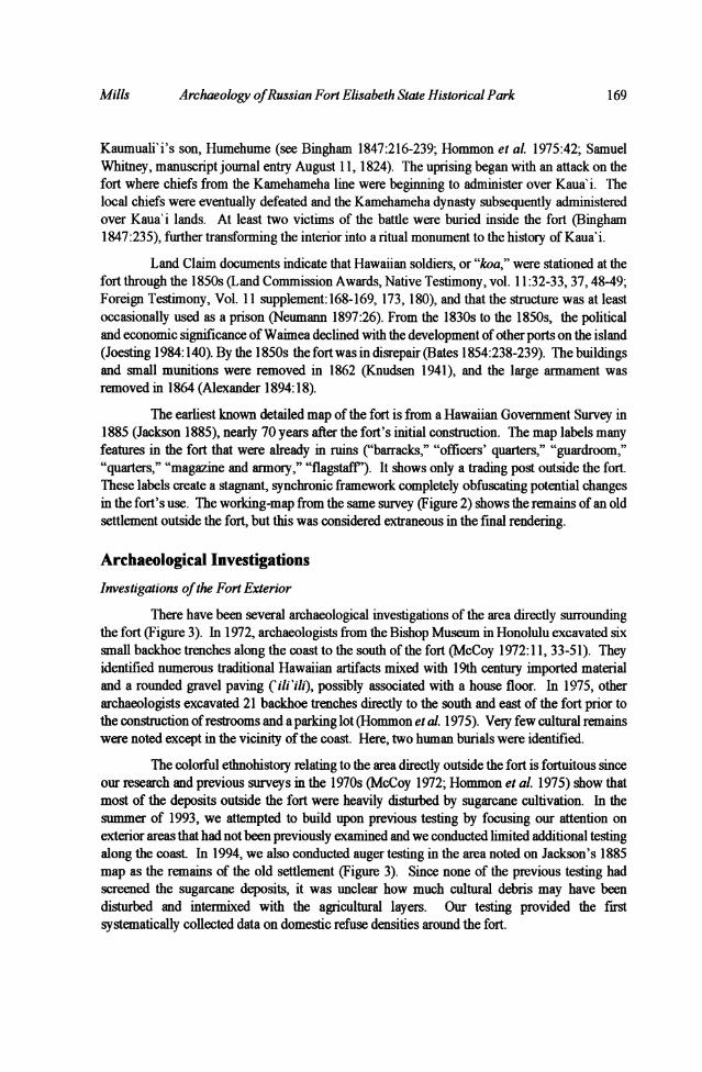
The earliest known detailed map of the fort is from a Hawaiian Government Survey in1885 (Jackson 1885), nearly 70 years after the fort's initial construction. The map labels manyfeatures in the fort that were already in ruins ("barracks," "officers' quarters," "guardroom,""quarters," "magazine and armory," "flagstaff'). It shows only a trading post outside the fort.These labels create a stagnant, synchronic framework completely obfuscating potential changesin the fort's use. The working-map from the same survey (Figure 2) shows the remains of an oldsettlement outside the fort, but this was considered extraneous in the final rendering.
Archaeological InvestigationsInvestigations ofthe Fort Exterior
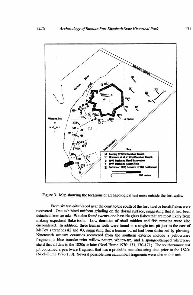
There have been several archaeological investigations of the area directly surroundingthe fort (Figure 3). In 1972, archaeologists from the Bishop Museum in Honolulu excavated sixsmall backhoe trenches along the coast to the south of the fort (McCoy 1972:11, 33-51). Theyidentified numerous traditional Hawaiian artifacts mixed with 19th century imported materialand a rounded gravel paving ('ili'ili), possibly associated with a house floor. In 1975, otherarchaeologists excavated 21 backhoe trenches directly to the south and east of the fort prior tothe construction ofrestrooms and a parking lot (Hommon et al. 1975). Very few cultural remainswere noted except in the vicinity of the coast. Here, two human burials were identified.
The colorful ethnohistory relating to the area directly outside the fort is fortuitous sinceour research and previous surveys in the 1970s (McCoy 1972; Hommon et al. 1975) show thatmost of the deposits outside the fort were heavily disturbed by sugarcane cultivation. In thesummer of 1993, we attempted to build upon previous testing by focusing our attention onexterior areas that had not been previously examined and we conducted limited additional testingalong the coast. In 1994, we also conducted auger testing in the area noted on Jackson's 1885map as the remains of the old settlement (Figure 3). Since none of the previous testing hadscreened the sugarcane deposits, it was unclear how much cultural debris may have beendisturbed and intermixed with the agricultural layers. Our testing provided the firstsystematically collected data on domestic refuse densities around the fort.
Mills 169

Kroeber Anthropological Society Papers
Figure 2. Detail of George Jackson's 1885 "Working Map" of Waimea, Kaua'i, showing"Remains of old Settlement" outside the fort walls. Hawaii State Survey Office, Reg. #1362
170 No. 81
Archaeology ofRussian Fort Elisabeth State Historical Park
Figure 3. Map showing the locations of archaeological test units outside the fort walls.
From six test-pits placed near the coast to the south ofthe fort, twelve basalt flakes wererecovered. One exhibited uniform grinding on the dorsal surface, suggesting that it had beendetached from an adz. We also found twenty-one basaltic glass flakes that are most likely frommaking expedient flake-tools. Low densities of shell midden and fish remains were alsoencountered. In addition, three human teeth were found in a single test-pit just to the east ofMcCoy's trenches #2 and #3, suggesting that a human burial had been disturbed by plowing.Nineteenth century ceramics recovered from the southern exterior include a yellowwarefragment, a blue transfer-print willow-pattern whiteware, and a sponge-stamped whitewaresherd that all date to the 1820s or later (Noel-Hume 1970: 131, 170-17 1). The southernmost testpit contained a pearlware fragment that has a probable manufacturing date prior to the 1820s(Noel-Hume 1976:130). Several possible iron cannonball fragments were also in this unit.
Mills 171
KroeberAnthropological Society Papers
In short, based upon the previous archaeology and our testing, the southem coastal areacontained at least three human burials and a sparse scatter of traditional Hawaiian domesticmidden intermixed with 19th century material. Based upon his limited testing, McCoy (1972:52)suggested that the Hawaiian midden pre-dates the construction of the fort. Our testing could notconfirm or refute this inference, but demonstrates that only low densities of cultural material areintermixed with the sugarcane deposits, suggesting that the site was not extensive and was notoccupied for great lengths of time. The most common features were not domestic; they werehuman burials.
Between the coast and the south fort wall in the area marked "Remains of OldSettlement" on Jackson's 1885 map, we excavated twenty-nine six-inch diameter auger holes inthe cane deposits. No lithic debitage was found in any of these auger tests, but sparse scatters ofrounded basalt gravel were found in eight auger holes. These stones were probably brought tothe terrace as 'ili'ili pavings for house floors and were dispersed by sugarcane plowing. Darkand light olive green glass fragments characteristic ofwine bottles and case gin bottles were alsofound in one auger test.
On the terrace between the fort and the Waimea River, bedrock was exposed or layclose to the surface in many places. While the deposits were thin, they were relativelyundisturbed. No volcanic glass or basaltic debitage were found here at all, suggesting thatprehistoric activity on this bank of the Waimea River was limited. A small stone enclosure(Figure 3) was still visible in this area and contained pig bone, metal cans, highly corroded squarenails, a pearlware fragment, and various glass bottle fragments including a hand-tooled dip-molded wine bottle. Fourteen meters north of the enclosure, an'ili 'ili paving nearly abuts therubble at the base of the fort wall, possibly suggesting the location of another house floor. In thetwo units north of this location on the same terrace, we recovered a small scatter of carbonatecemented plaster, which we called "coral mortar," and rivenine silt/clay deposits. The clay andplaster may be the remains of an adobe-walled structure that had been plastered with coralmortar. This was a common building form in mid-l 9th century Hawaiian architecture. The samearea contained pig bone, fish bone, shell, and olive green bottle glass.
By the main entrance to the fort where a "trading house" is sketched on the 1885 map,we documented the presence of a clay-lined pit possibly used for mixing adobe, and an adjacenthearth and midden with abundant fish, pig, bird, and marine shell remains. The only datablematerials here were a 1906 nickel found in the fill of the pit and a sherd from a thick-walledcreamware vessel, such as a chamber-pot, that was most likely manufactured in the late 18th orearly 19th century (Noel-Hume 1976:123-128). The creamware sherd was found on the surface,and is a poor indication of the age ofthe domestic midden. Hawaiian land-claim records suggestthat the commandant of the fort was living in this general area in the 1850s (Land CommissionAwards, Native Testimony, 11:32-33). It is most likely that this is what Jackson saw in 1885rather than a Russian "trading house."
On the river-bank by the main entrance, there is a stone wharf that appears to be wheregoods were brought to the fort by boat (Figure 4). We mapped the revetment and divers surveyedthe river bottom, but could determine very little about the deposits due to poor visibility. Wealso documented the presence of a tunnel built through the base of the fort wall exiting on theside facing the Waimea River (Figure 5). This may be a "sally port," or secondary exit from the
172 No. 81
Archaeology ofRussian Fort Elisabeth State Historical ParkMills 173
o0m
*-d
p4-CA
SeO
ci
U
,0
0g
_4 u
GO)tC14 CrE
CN
O
Z)U1*
Kroeber Anthropological Society Papers
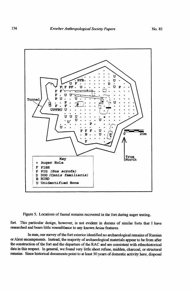
Figure 5. Locations of faunal remains recovered in the fort during auger testing.
fort. This particular design, however, is not evident in dozens of similar forts that I haveresearched and bears little resemblance to any known heiau features.
In sum, our survey ofthe fort exterior identified no archaeological remains ofRussianor Aleut encampments. Instead, the majority of archaeological materials appear to be from afterthe construction of the fort and the departure of the RAC and are consistent with ethnohistoricaldata in this respect. In general, we found very little sheet refuse, midden, charcoal, or structuralremains. Since historical documents point to at least 50 years of domestic activity here, disposal
174 No. 81
Archaeology ofRussian Fort Elisabeth State Historical Park
of refuse in the ocean or river, and low-visibility grass thatch housing may be partiallyresponsible for the lack of recognizable midden and structural debris. Since this site is on a levelterrace at the mouth of the major drainage on the west side of Kaua'i, the paucity ofarchaeological deposits is in itself interesting. Other than the burials along the coast and sparsedomestic deposits in the same vicinity, there is little evidence for prehistoric activity here. Oneexplanation for this paucity of prehistoric domestic refuse is that the east bank of the WaimeaRiver was part of a long-standing ritual sphere of Hawaiian life separated from the domesticlandscape on the west bank. This hypothesis is supported by the early historical accounts ofWaimea.
Fort Interior
Inside the fort, we have limited ethnohistorical data and archaeology is in the bestposition to fill many of the gaps. Luckily, significant impacts within the fort appear to be limitedto its dismantlement in the 1 860s and gradual decay. The missionaries did not frequently reporton activities inside the fort, other than mentioning that two individuals were buried there afterthe 1824 battle (Bingham 1847:235), and that Kaumuali'i's grandson was buried there in 1822(Mercy Whitney, manuscript journal entry for February 9, 1822). Most interpretations of interiorstructures come from the 1885 map. Our fieldwork was aimed at testing the validity of thefunctions assumed in 1885 through an analysis of architectural designs and associated refusedeposits.
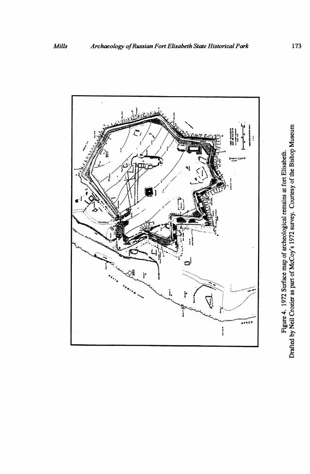
The Bishop Museum survey in 1972 cleared rubble from the fort walls and stairwaysleading to the old cannon emplacements, documented stone pavings by the fort entrance, andgenerated a detailed surface map (Figure 4). The report provided the first detailed descriptionsof archaeological features visible on the surface. In addition to the prominent central features ofthe "flagpost," "barracks," and "magazine and armory," McCoy located several stone alignmentsaround the interior perimeter that confirm that there were structures in the locations marked as"quarters" and "officer's quarters" on Jackson's map as well as additional foundations notsketched by Jackson. McCoy described the walls of the fort as double stone facings filled witha rubble core of earth and rock. As I previously stated, the use of earth in the construction ofheiau or other stone structures in Hawaii was not traditional. McCoy (1972:13) suggests that theuse of earth fill was a functional consideration for withstanding artillery bombardment. Thisinference provides a reasonable hypothesis for why the walls of the structure did not followtraditional Hawaiian practices in the construction of monumental architecture. Taking this intoconsideration, there is no reason to suggest that the use of earth in wall construction is evidenceagainst this structure having Hawaiian ritual significance given the new functional demands ofthe monumental architecture.
An aspect of the wall construction not mentioned by McCoy is a large oblong boulderin the exterior wall-facing near the entrance. The boulder was placed in the wall in a verticalposition. Such stones often represented deities in Hawaiian ritual and were occasionallyincorporated in heiau architecture (Kirch 1985:168). There is little reason to suggest that thevertical placement of the boulder was a function of foreign architectural design.
Also of interest is the large dry-laid stone platform used as a support for the flagpost:
Fifteen meters W of the barracks is the flagstaff, marked by a roughly rectan-
Mills 175
Kroeber Anthropological Society Papers
guiar stone mound 5 x 6 meters and 1.54 meters high. A maximum of fourtiers of stones is evident at the southwest corner. The top platform, measuring
3.3 meters x 3 meters, is paved. In the center is a stone-lined depression 70 x
80 x 30 cm, for insertion ofthe flagpole. The mound was constructed on a rockoutcrop of basaltic stones averaging 20 to 30 cm in diameter (McCoy1972:18).
This flagpost base bears a resemblance to stone platforms in heiau used for offerings or sacrifice(lele). One may argue that it was the only way to support the base of the flagpost over bedrock.Our subsurface investigations of the fort interior, however, revealed that most of the soil is quitedeep; a flagpost base could have been erected with much less work.
Subsurface investigations of the fort interior were preceded by non-destructive remote-sensing. Non-destructive tests were attempted by the United States Soil Conservation Serviceincluding magnetometer and ground penetrating radar (Doolittle 1990:11,12,14-16), but theresults were far from decisive for establishing specific testing locations. Simple metal detectionwas also difficult since the high iron content of the bedrock and soil resulted in ubiquitouspositive readings.
We then used a power auger in a 5 m. grid to identify spatial patterns. The auger resultswere extremely interesting. Virtually all domestic midden was located around the interiorperimeter near small structural foundations. Figure 5 shows the distribution of terrestrial faunalremains. Marine shell, nutshells, 19th century glass, and a sparse scatter of historical ceramics
all show similar distributions. No domestic midden was found by the raised central platfonn in
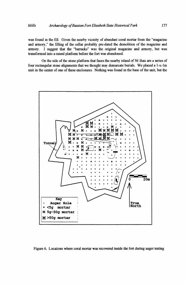
the fort that was assumed to be the "barracks." Coral mortar was found in the vicinity of the"magazine and armory," the "guardroom," and in an additional area by the fort entrance whereno building was portrayed on the 1885 map (Figure 6). It was made from burned coral and shellmixed with local sands and silt.
Grain-size and compositional analyses of the mortar suggest that the guardroom coralmortar and the mortar from the magazine and armory were made from distinctive batches ofsediment. The scatter of coral mortar by the entrance matches the batch from the magazine andannory and is found in relatively low density. This latter scatter may be explained by thedemolition of the magazine and armory and the re-use of its coral blocks. The blocks may havebeen stacked near the entrance of the fortin preparation for their removal and mortar adhenrngto the blocks may have fallen off. Nevertheless, there is a consistent scatter of glass, faunalmaterial, shell, and other domestic refuse in this same area that may indicate the former presence
of a structure.
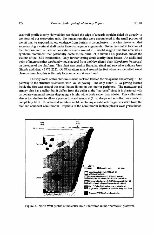
Excavation of the "barracks" platform revealed a buried cellar with adobe plaster on thefloor and wall (Figure 7). Artifacts from the floor include a musketball and several brass tacksand a small burn area (Feature 15). Wood charcoal on the floor consists of alahe'e (Canthiumodoratum), an indigenous dryland tree. The cellar, however, had been purposefully filled withtwo meters offne silt forming a raised platform. Much of the silt deposit still retains imprintsof grass, densely packed in the silt, suggesting that adobe blocks were used to fill the cellar. Theadobe blocks were not intact and were mixed with unconsolidated silt, and various rocks. Inshort, it appears that someone went to a lot of work to dig a cellar and someone else went to a lotof work tofill it, creating a platform with no subsequent signs of domestic use. No coral mortar
176 No. 81
Archaeology ofRussian Fort Elisabeth State Historical Park
was found in the fill. Given the nearby vicinity of abundant coral mortar from the "magazineand armory," the filling of the cellar probably pre-dated the demolition of the magazine andarmory. I suggest that the "barracks" was the original magazine and arnory, but wastransforned into a raised platform before the fort was abandoned.
On the side of the stone platform that faces the nearby island of Ni'ihau are a series offour rectangular stone alignments that we thought may demarcate burials. We placed a l-x-lmunit in the center of one of these enclosures. Nothing was found in the base of the unit, but the
Figure 6. Locations where coral mortar was recovered inside the fort during auger testing
Key+ Auger RoleX <5g mortarM 5g-50g mortarM >50g mortar
Mills 177
Kroeber Anthropological Society Papers
east wall profile clearly showed that we nicked the edge of a nearly straight-sided pit directly tothe north of our excavation unit. No human remains were encountered in the small portion ofthe pit that we exposed, so our evidence from burials is inconclusive. It is clear, however, thatsomeone dug a vertical shaft under these rectangular alignments. Given the central location ofthe platform and the lack of domestic remains around it, I would suggest that this area was asymbolic monument that potentially contains the burial of Kaumuali'i's grandson and/or thevictims of the 1824 insurrection. Only further testing could clarify these issues. An additionalpoint of interest is that we found wood charcoal from the Hawaiian ti plant (Cordylinefruiticosa)on the edge of the platfonn. This plant was used in Hawaiian ritual and served to indicate kapu(Handy and Handy 1972:222). Of 58 locations in and around the fort where we identified woodcharcoal samples, this is the only location where it was found.
Directly north of this platform is what Jackson labeled the "magazine and armory." Thepathway to the structure is covered with 'i1i 'i1i paving. The only other 'ili 'i1i paving locatedinside the fort was around the small house floors on the interior periphery. The magazine andarmory also has a cellar, but it differs from the cellar at the "barracks" since it is plastered withcarbonate-cemented mortar displaying a bright white body rather than adobe. This cellar-holealso is too shallow to allow a person to stand inside it (1. lm deep) and no effort was made tocompletely fill it. It contains demolition rubble including coral-block fragments sawn from thereef and abundant coral mortar. Imprints in the coral mortar include plaster over grass thatch,
Figure 7. North Wall profile of the cellar-hole uncovered in the "barracks" platform.
N71 N71W45 W44
Slcmbd --
-Bsic rock W- Wood
O ery fine dusky red (:0R314) dtwhnostucture.
2mbd - gm" Dark reddish brown (2-5YR3/4) fine ittEEJ bocky structure and sall charrool flecks.
Red (25YR4/8) itwlth some odobe blockfragments, but prdnnttfy lacking structuire.
*DarkredC2.5YR3/6)adobe picster.
178 No. 81
Archaeology ofRussian Fort Elisabeth State Historical Park 179
plaster over a rock or coral-block face, and mortar from between stones or coral block.Primarily, the imprints are from plaster and from between blocks, suggesting that the structureprobably had coral-block and stone walls. The plaster applied to grass thatch may be from a roof.
At this structure, there is little evidence of domestic midden that would suggest thatpeople lived there for extended periods. This in combination with the substantial cellar and solidwall construction corroborates an interpretation as a "magazine and armory." The heavy coatingof coral mortar over the grass thatch could be an attempt at fire-proofing. The need for suchprotection is supported by missionary reports of four separate fires around the fort in one year.This structure remains a good candidate for a safe storage location of black powder and arms.Due to the fact that adobe was used in the construction of the fort walls and one cellar, I wouldargue that the coral mortar at the magazine and armory is from a post-Russian period ofconstruction. Making coral mortar was labor intensive and was generally limited to publicbuildings and houses of elite chiefs and foreigners. A British advisor to Kamehameha, JohnYoung, used coral mortar plaster on his house on Hawai' i Island as early as 1799 (Apple 1978;Rosendahl and Carter 1988), but the general use of this material appears to be minimal until thelate 1820s. The earliest reference to coral mortar on Kaua' i that I have found is on a house theWhitneys built in 1829 (Mercy Whitney Journal May 15, 1829; Mortelier 1992:106). SamuelWhitney stated in 1820 that there wasn't enough lime on the island to make soap (Damon1925:210). The late construction date of the "magazine and armory" is further supported by aburied mortar and rock alignment under the path leading to the structure.
The "guardroom" (directly inside and to the east of the fort entrance) has coral mortarremains with a dark red body and stick-thatch imprints. The kind of imprint in the mortar iscompletely lacking elsewhere in the fort. The stick thatching may represent a transformation oftraditional Hawaiian grass-house framing to support the weight of a coral mortar plaster. Whilecoral mortarwas used on both the magazine and armory and the guardroom, the different framingof the individual buildings suggests that the "guardroom" was more expediently constructed.The peripheral location and the less substantial framing of the guardroom may indicate a lesssignificant role for this structure. The mortar may be an indication of an attempt at fire-proofmg,but this could be the result of cooking rather than gunpowder storage. Domestic activity at theguardroom is corroborated by abundant deposits of domestic midden including fish, dog, pig,and mollusk.
A final area where we excavated was in the southeast interior of the fort. There arestone enclosures here that were not on the 1885 map and have been assumed to post-date it. Thestairway to the southeastern projection is also blocked off forming a wall, possibly for an animalpen. We excavated behind the blocked stairway to confirm that nothing was inthe fill; nothingwas. We also excavated inside one of the stone enclosures and exposed a gravel paved floorscattered with traditional Hawaiian midden including a drilled dog-tooth canine. Interestingly,the interior of the stone enclosure contained the most military items found inside the fort. Theseinclude ten lead musketballs of various caliber, a broken brass trigger, and a trigger-plate thatmatches a Brown Bess flintlock rifle. The Brown Bess is a British make common in theAmerican Revolution that ceased to be manufactured by the 1830's (Noel-Hume 1976: 216).Ceramics from the structure include fragments of transitional pearlware from a teacup and abowl, and a low-grade ironstone from a commercial food-pot. Ifthis is truly a stiucture built after1885, it appears that the occupants were collecting old musketballs, gun pieces, and pearlware
Mills
Kroeber Anthropological Society Papers
ceramics. The low-grade ironstone food pot provides the latest date for the use of the structuresometime in the 1850s or after, and this does little to suggest a date of use after 1885. WhenJackson made his map, it was apparently drawn as he thought it looked when the Russians were
there (Daily Pacific CommercialAdvertiser, May 18, 1885, Hommon et al. 1975:180). This notein combination with the archaeological data would suggest that the structure was there by 1885and may have been in use in the last formal days of the fort's occupation in the 1 850s and 1 860s.
In sum, there is a great diversity of architectural form within the fort. I suggest that the"barracks" was the original magazine and represents the earliest structure within the fort. It hasa central location, matches the construction techniques used in the fort walls, and the use ofadobe generally pre-dates the popular use of coral mortar in other sites in Hawaii in the 19thcentury. There were probably several other structures as noted on Jackson's 1885 map on theperimeter of the fort that may be early features, but their date of construction is less clear. Theseperimeter locations correspond with greater densities of artifacts in our auger tests. The lack ofstructural material leaves one to infer that the walls were plank wood, grass-thatch, or adobe, butlittle was found that would suggest dates of construction. If the walls were plank wood, the nailswere also mostly recycled.
Following the initial adobe (and possibly wood or grass-thatch) phase of construction,I suggest that the coral-mortar buildings including the "guardroom" and the "magazine andarmory" were constructed and the "barracks" was transformed into a stone-lined earthenplatform, possibly incorporating the burials of people who died in the 1824 insurrection andKaumuali'i's grandson. In essence, the "barracks" became a monument to the fort's own history.It continued to occupy a central location in the fort with no associated domestic activity, and a
new magazine and armory was built adjacent to it. Between the flagpost, the platform, and themagazine and armory, the center of the fort symbolized the power, or mana, of the monument.This structural layout probably occurred between the late 1820s and the 1840s when the fort andWaimea were still significant in Hawaiian politics.
Afmal construction phase is represented by the stone enclosures in the southeast corner
of the interior that appear to date to the last period of the fort's occupation in the 1850s and1 860s. These structures are stone-lined at their base, and probably had thatched walls and roofs.The lack of labor investment in the construction and framing of these enclosures belies thewaning significance of the monument in the later 19th century.
Concluding RemarksFor over a century, historians have told and retold the story of "Russia's Hawaiian
Adventure" and of the flamboyant and foolhardy actions of Dr. Schaiffer that resultedin theconstruction of Fort Elisabeth. There is an underlyingimpressionin many of these accounts thatKaumuali'i was only a dupe in an overly ambitious scheme concocted for Russian benefit. Thisarchaeological and ethnohistorical project could have taken the same perspective and wouldhave found nothing more than a few military relics and noted details on the fort's architecture as
they relate to classic European designs. But I feel that historical archaeology has both theobligation and opportunity to explore the untold stories. Specifically, I consider it imperative toaddress the roles and motivations of Hawaiians in order to understand the potentially diversecultural meanings in this unique monument. As the archaeology and ethnohistory demonstrate,
180 No. 81

Archaeology ofRussian Fort Elisabeth State Historical Park
there is very little about the site that is truly "Russian." It was built in a land far from Russia andin a time ofrapid changes in Hawaiian culture where we have few comparative standards to formexpectations of what happened.
Fort Elisabeth State Historical Park contains a manifest representation of the "structureofthe conjuncture" (Sahlins 1981:35). Russian texts provide one avenue to help understand thatstructure, but only begin to address its full form and the nature of its historical transformations.The archaeological data and expanded ethnohistorical research presented herein attempt toportray the complex inter-relationships of indigenous and foreign agendas that form the site'shistory. At first glance, the construction of Fort Elisabeth suggests dramatic culture changedominated by European concepts and goals. Many of the fort features, however, can be seen toreflect Hawaiian agendas. These factors include the choice ofthe fort's location on kapu ground,its monumental size, the choice of stone as a building material, the reasons why the fort was built,the continued modiflcation of the fort after the Russians left, and the reported use of the fort asa burying place. It needs to be recognized that this single structure may have had vastly differentmeanings through time for the people who built and used it.
References CitedABCFM (American Board ofCommissioners for Foreign Missions)
1816 A Narrative ofFive Youthfrom the Sandwich Islands, now receiving an Education in this Coun-try. New York: J. Seymour.
Alexander, W.D.1894 The Proceedings ofthe Russians on Kauai. Papers ofthe Hawaiian Historical Society No. 6.
Anonymousn.d. "Log ofthe Atahualpa," Original MS at the Massachusetts Historical Society Library, Boston.
[Note: The MHS Library attributes authorship to William Sturgis, but the same Log notes that"Sturgis" leaves for Canton in early 1814.]
Apple, Russell1978 Pahukanilua: Homestead ofJohn Young, Kawaihae, Kohala, Island ofHawaii. Honolulu: Na-
tional Park Service.Barratt, Glynn1987 The Russian Discovery ofHawai'i. Honolulu: Editions Limited.1988 The Russian View ofHonolulu 1809-1826. Ottawa, Canada: Carleton University Press.
Bates, George W.1854 Sandwich Island Notes, by a Haole. New York: Harpr & Brothers.
Beaglehole, J. C. (ed).1967 The Joumnals ofCaptain James Cook on His Voyage ofDiscovery: the Voyage ofthe Resolution
andDiscovery 1776-1780, Parts 1 and 2. London: Cambridge University Press.
Beresford, William1968 [1789] A VoyageRoundthe World..performedin 1785,1786,1787and1788. GeorgeGoulding,
London. Reprinted in 1968, New York: De Capo Press.
Biersack, Aletta1990 Clio in Oceania: toward a HistoricalAnthropology. Washington, D.C.: Smithsonian Institution.
Mills 181
KroeberAnthropological Society Papers
Bingham, Hiram1847 A Residence of21 years in the Sandwich Islands. Tokyo: Charles E. Tuttle Co.
Bishop, Charles1966 The Jowunal andLetters ofCaptain CharlesBishop on the North West Coast ofAmerica, in the
Pacific and in New South Wales, 1794-1799. Michael Roe, editor. Hakluyt Society, London:Cambridge University Press.
Bolkhovitinov, Nikolai N.1973 The Adventures ofDoctor Schaffer in Hawaii, 1815-1819. Translated by Igor V. Vorobyoff. Ha-
waiian Journal ofHistory 7:55-78.Bradley, Harold Whitman
1942 TheAmericanFrontierinHawaii:.ThePioneers1789-1843.Stanford:StanfordUniversityPress.Campbell, Archibald1822 A Voyage Round the World,from 1806 to 1812. Charleston, South Carolin: Duke and Brown
Publishers. 1967 Facsimile Reproduction ofthe Third Edition. Honolulu: University ofHawaiiPress.
Chevigny, Hector1965 Russian America: the GreatAlaskan Venture:1741-1867. Portland, Oregon: Binford and Mort
Publishing.Colnett, James1940 The Jowunal ofCapt James Colnett aboard the Argonautfrom April 26, 1789 to November 3,
1791. F.W. Howay, editor. Toronto: Champlain Society.Corney, Peter1965 [1896] Voyages in the North Pacific: Narrative ofseveral trading voyagesfrom 1813 to 1818,
between the northwest coast ofAmerica, the Hawaiian Islands, and China, with a description ofthe Russian establishments on the Northwest Coast. Thos. G. Thrum, Publisher, Honolulu. Re-print, Fairfield, Washington: Ye Galleon Press.
Damon, Ethel M.1925 The first Mission Settlement on Kauai. The Friend, September edition pp.204-210, October edi-
tion 224-235, Honolulu.Dening, Greg1988 History 'sAnthropology: the Death of William Gooch. Association for Social Anthropology in
Oceania, Special Publication No. 2. Lanham, New York: University Press ofAmericaDoolittle, James A.
1990 Archaeological Studies in Hawaii using Ground Penetrating Radar Techniques. Unpublisheddocument prepared by the U.S. Soil Conservation Service, on file at the Dept. for Historic Pres-ervation, Honolulu.
Emerson, N. B. M.D.1900 The Honolulu Fort. Eighth AnnualReport ofthe Hawaiian HistoricalSociety. pp 11-25. Hono-
lulu: Robert Greive Publishers.Forbes, David W.
1992 Encounters with Paradise. Honolulu: Honolulu Academy ofArts.Golder, Frank A.1930 Proposals for Russian Occupation ofthe Hawaiian Islands. In The Hawaiian Islands. pp. 39-
182 No. 81
Archaeology ofRussian Fort Elisabeth State Historical Park
49. Albert P. Taylor, editor. Captain Cook Sesquicentennial Commission and the Archives ofHawaii Commission, Honolulu.
Gronski, Paul1928 Les Russes aux iles Hawaii au debut du XIX siecle. Le Monde Slave Vol. 4. (The Russians in
the Hawaiian Islands in the Beginning ofthe Nineteenth Century), translated by Margaret Faye.MS on file at the Division of State Parks, Honolulu.
Handy, E.S. Craighill and Elizabeth Green Handy1972 Native Platers in OldHawaii: Their Life, Lore andLegends. Bishop Museum Bulletin 233, Hb
nolulu.Hill, Samuel
1937 Voyage ofthe Ophelia...Excerpts from the Journal of Captain Samuel Hill. James W. Snyder,Jr., editor. New England Quarterly 10(2):355-380.
Hommon, Robert J., Catherine Stauder, D.W. Cox and Francis Ching1975 Preliminary Report on Archaeological and Historical Research at Fort Elizabeth (Phase I),
Waimea, Kona, Kaua'i Island. Arch. Report 14-36 I, Archaeological Research Center, Hawaii,Inc. Prepared for DLNR, Division of State Parks.
Howay, Frank W.1933 The Last Days ofthe Atahualpa, Alias Behring. Hawaiian HistoricalSocietyAnnualReportfor
1932 pp.70-80.I'i, John Papa
1959 Fragments ofHawaiian History. Honolulu: Bishop Museum Press.
Jackson, George E.G.1885 North Pacific Hawaiian Islands, Harbors ofKauai. From Hawaiian Government Surveys 1881-
85. Honolulu: Hawaii State Survey Office.Jarves, James Jackson1844 History ofthe Sandwich Islands. Second edition. Boston: James Munroe and Co.
Joesting, Edward1984 Kauai: The Separate Kingdom. Honolulu: University ofHawaii Press.
Kanakau, Samuel1992 Ruling Chiefs ofHawaii. Honolulu: Kamehameha Schools.
Kirch, Patrick V.1985 Feathered Gods andFishhooks. Honolulu: University ofHawaii Press.
Kolb, Michael John1991 Social Power, ChieflyAuthority, and CeremonialArchitecture, in an IslandPolity, Maui, Ha-
waii. Ph.D. Dissertation, Dept. ofAnthropology, UCLA.Kotzebue, Otto von
1967 [1821] A Voyage ofDiscovery into the South Sea andBering's Straits..., Reprint. London: DaCapo Press.
Knudsen, Eric1941 Shipment ofCannon, Guns etc. from the Russian Fort. Kauai Historical Society Papers, Vol.
2:499-500.
Land Commission Awardsn.d. Foreign and Native Testimony collected during the Great Mahele. Hawaii State Archives, Ho-
Mills 183
KroeberAnthropological Society Papers
nolulu.Lightfoot, Kent G. and Antoinette Martinez
1995 Fronteirs and Boundaries in Archaeological Perspective. Annual Review ofAnthropology24:471492.
Linnekin, Jocelyn1990 Sacred Queens and Women ofConsequence: Rank, Gender and Colonialism in the Hawaiian Is-
lands. Ann Arbor: University ofMichigan Press.
Loomis, Elisha1937 Copy ofthe Journal ofE. Loomis. Compiled by William D. Westervelt, MS on file, University
ofHawaii Library, Manoa.Mazour, Anatole G.
1937 Doctor Yegor Scheffer: Dreamer of a Russian Empire in the Pacific, Pacific Historical Reviewpp. 15-20.
McCoy, Patrick1972 Archaeological Research at Fort Elizabeth, Waimea, Kauai, Hawaiian Islands, Phase I. Bemice
P. Bishop Museum Dept. ofAnthro. Series 72-7.
Mehnert, Klaus1939 The Russians in Hawaii: 1804-1819. University ofHawaii Occasional Paper No. 38. Volume
18 (6), Honolulu.Mortelier, Christiane
1992 Waimea, Kaua'i in 1839: An Account by Louis Thiercelin, Whaling Doctor. The Hawaiian Jour-nal ofHistory 26:95-122.
Neumann, Paul1897 Captain Hypolite Bouchard and his treaty with Kamehameha I. Fifth AnnualReport ofthe Ha-
waiian Historical Society, pp. 22-28, Honolulu.Noel-Hume, Ivor1976 Artifacts ofColonialAmerica. New York: Alfred A. Knopf Publishers.
Okun, Semen B.1951 TheRussian-American Company. Translated from Russian by Carl Ginsburg. Harvard: Harvard
University Press.
Phelps, William Danen.d. Solid Men ofBoston in the Northwest. Handwritten MS at the Bancroft Library, written in the
late 1800s. Adele Ogden attributes authorship to W.D. Phelps.Pierce, Richard A.
1965 Russia's HawaiianAdventure, 1815-1817. Berkeley and Los Angeles: University ofCaliforniaPress.
Porter, David1822 Journal ofa CruiseMade tO the Pacific Ocean, by Capt DavidPorter, in the UnitesStatesFrig-
ate Essex in the Years 1812, 1813, and 1814-..2 volumes. New York: Wiley and Halstead.Portlock, Nathaniel
1968 [1789] A Voyage Round the World but more particularly to the Northwest Coast ofAmerica.London: John Stockdale. Reprint. New York: De Capo Press.
184 No. 81
Archaeology ofRussian Fort Elisabeth State Historical Park
Rosendahl, Paul H. and Laura Carter1988 Excavations atJohn Young's Homestead, Kawaihae, Hawaii. National Park Service, Western
Archaeological Conservation Center, Publications in Anthropology, No. 47.Sahlins, Marshall
1981 HistoricalMetaphors andMythical Realities: Structure in the Early History ofthe Sandwich Is-landKingdom. Ann Arbor: The University ofMichigan Press.
1985 Islands ofHistoy. Chicago: University ofChicago Press.1992 Historical Ethnography, Volume 1 ofAnahulu: the Anthropology ofHistory in the Kingdom of
Hawai'i, by Patrick V. Kirch and Marshall Sahlins. Chicago: University ofChicago Press.Stauffer, Bob1994 Debora Kapule ofWailua, Kaua 'i. Report Prepared for the Division of State Parks, Dept. of
Land and Natural Resources, Honolulu.Thrum, Thomas. G.1906 Tales from the Temples, Part I. Hawaiian Almanac andAnnualfor 1907, pp.49-69.
Tikhmenev, P. A.1978 A History ofthe Russian-American Company. Translated from Russian by R.A. Pierce and Al-
ton S. Donnelly. Seattle: University ofWashington Press.Tunarkin, D.D.1964 Vtorzhenie kolonizatorov v kaui vechnoi vesny. Moscow, Nauka. Typescript MS translation
of pp. 139-141 by Patricia Polansky on file at the Division of State Parks, Honolulu.Valeri, Valerio1985 Kingship andSacrifice: Ritual andSociety inAncientHawaii. Chicago: University ofChicago
Press.1990 The Transformation of a Transformation: a Structural Essay on an Aspect ofHawaiian History
(1809 to 1819). In A. Biersack (ed.) Clio in Oceania: toward a Historical Anthropology. Wash-ington, D.C.: Smithsonian Institution Press.
Vancouver, George1984 [17981 A Voyage ofDiscovery to the North Pacific Ocean andround the World... in the years
1790, 1791, 1792, 1793, 1794 and 1 795... Printed for G.G. and J. Robinson, London. Reprintedby the Hakluyt Society, edited by W. Kaye Lamb (4 vols.), with an introduction and appendices,London.
Wallerstein, Immanuel1974 The Modern WorldSystem. New York: Academic Press.1980 The Modern WorldSystem 1. New York: AcademicPress.
Westerverlt, William D.1915 Legends ofOldHonolulu. Boston: Ellis Publishers.
Whitney, Mercyn.d. Unpublished MS Journal. Original copy at the Hawaiian Mission Children's Society Library,
Honolulu.Whitney, Samuel
n.d. Unpublished Manuscript Journal for August 11, 1824. Original copy at the Hawaiian MissionChildren's Society Library, Honolulu.
1838 Account ofan Alleged Attempt on the Part ofthe Russians to take Possession ofthe Island ofKauai. Hawaiian Spectator 1:48-51.
Mills 185

186 Kroeber Anthropological Society Papers No. 81
Zwiep, Mary1991 Pilgrim Path. Madison: University ofWisconsin Press.
Acknowledgments. I count 52 participants in the actual fieldwork, and we weresupported by many others. I would like to briefly acknowledge the assistance of State Parksarchaeologists Martha Yent and Alan Carpenter, Nancy McMahon from the State HistoricPreservation Division, Pila Kikuchi from Kaua'i Community College, Calvin Shirai of theKaua'i West Main Street Organization, staff from the Koke'e Museum, Kaua'i Museum, Gayand Robinson, Cultural Surveys Hawai'i, Biosystems Analysis, Inc., and Quick Tents, Inc.. Iwould also like to thank Kent G. Lightfoot and Patrick V. Kirch for their invaluable guidanceduring this research. Field research and analysis has been supported with grants from the StahlResearch Foundation.