Embed Size (px)
Citation preview

Historical DigitalHistorical DigitalOrthophotography 101Orthophotography 101
John Erickson, Certified PhotogrammetristJohn Erickson, Certified PhotogrammetristJason Krueger, Project ManagerJason Krueger, Project Manager
Visualize the past to assist in predicting the future.Visualize the past to assist in predicting the future.

OVERVIEWOVERVIEW
Who Are We?Who Are We? UsersUsers Examples of FunctionalityExamples of Functionality Photo ResearchPhoto Research Define ProductDefine Product Acquisition CostAcquisition Cost AccuracyAccuracy Three Production StrategiesThree Production Strategies Software OptionsSoftware Options Understand LimitationsUnderstand Limitations

Who We Are…Who We Are…
Located in Sun Prairie, WILocated in Sun Prairie, WI Founded in 1999Founded in 1999 Provide photogrammetry and spatial Provide photogrammetry and spatial
data content development servicesdata content development services
Chris Gross & Dave Hart
Owners
Continental MappingContinental MappingConsultants, Inc.Consultants, Inc.

Our WorkOur WorkProjects in over 28 statesProjects in over 28 statesTwo market segmentsTwo market segments
Upper MidwestUpper Midwest• State & Local GovernmentsState & Local Governments• UtilitiesUtilities• ManufacturingManufacturing• EngineersEngineers• DevelopersDevelopers
Nationwide with Strategic PartnersNationwide with Strategic Partners• State DOTsState DOTs• DefenseDefense• Local/State GovernmentLocal/State Government• UtilitiesUtilities

CMC Specialized ServicesCMC Specialized Services Aerial Photography (B/W, color, infrared, oblique)Aerial Photography (B/W, color, infrared, oblique)
Airborne GPS/IMUAirborne GPS/IMU Topographic MappingTopographic Mapping GIS Base Mapping/feature IntegrationGIS Base Mapping/feature Integration Digital OrthophotographyDigital Orthophotography
Historical rectification and photo interpretation/classificationHistorical rectification and photo interpretation/classification Transportation Design Mapping (VHA)Transportation Design Mapping (VHA) Floodplain Delineation MappingFloodplain Delineation Mapping Laser Terrain Mapping (LIDAR)Laser Terrain Mapping (LIDAR) Municipal Mapping and ALTA’sMunicipal Mapping and ALTA’s Softcopy Photogrammetry ExtractionSoftcopy Photogrammetry Extraction

Recent ProjectsRecent ProjectsDefense Geo-IntelligenceDefense Geo-IntelligenceFort McCoyFort McCoyAmerican Transmission CompanyAmerican Transmission CompanyWisconsin DOT Master ContractWisconsin DOT Master ContractCity of MarshfieldCity of Marshfield

USERSUSERS
County/Local GIS and LIO departmentsCounty/Local GIS and LIO departments
Regional/County/Local PlanningRegional/County/Local Planning
Zoning DepartmentsZoning Departments

USERSUSERS
“By scanning and geo-referencing our historic aerials it allowed us to take them from the map drawers and make them part of the county's GIS system. It eliminated staff having to pull aerials for the public and make copies, they are now viewable on our website.”
“By scanning and geo-referencing our historic aerials it allows us to view them within our GIS system and understand how land use on properties have change.”
– Terry Dietzel, Fond du Lac County Assistant Planner

USERSUSERS
“ “These images rock”These images rock”– Ken Pabich, Calumet County Land Information OfficerKen Pabich, Calumet County Land Information Officer

EXAMPLES OF FUNCTIONALITYEXAMPLES OF FUNCTIONALITY
Change detection and trend identificationChange detection and trend identification Urban sprawl – growth planningUrban sprawl – growth planning Macro and MicroMacro and Micro
Stormwater runoffStormwater runoff

EXAMPLES OF FUNCTIONALITYEXAMPLES OF FUNCTIONALITY
Web-enabledWeb-enabled Asset ManagementAsset Management Changes in water ways and wetlandsChanges in water ways and wetlands Transportation network changesTransportation network changes
(great in areas with major changes(great in areas with major changes))

EXAMPLES OF FUNCTIONALITYEXAMPLES OF FUNCTIONALITY
Historical land use changesHistorical land use changes Historical views of urban areasHistorical views of urban areas Educational tool for discussing land use changes Educational tool for discussing land use changes
over timeover time Verify zoning maps/filesVerify zoning maps/files

1938 Urban Land Cover1938 Urban Land Cover1992 Urban Land Cover1992 Urban Land Cover
Tracking Urban SprawlTracking Urban Sprawl
1938 Imagery1938 Imagery 1992 Imagery1992 ImageryData Source: Calumet County, WI
Appleton, WIAppleton, WI

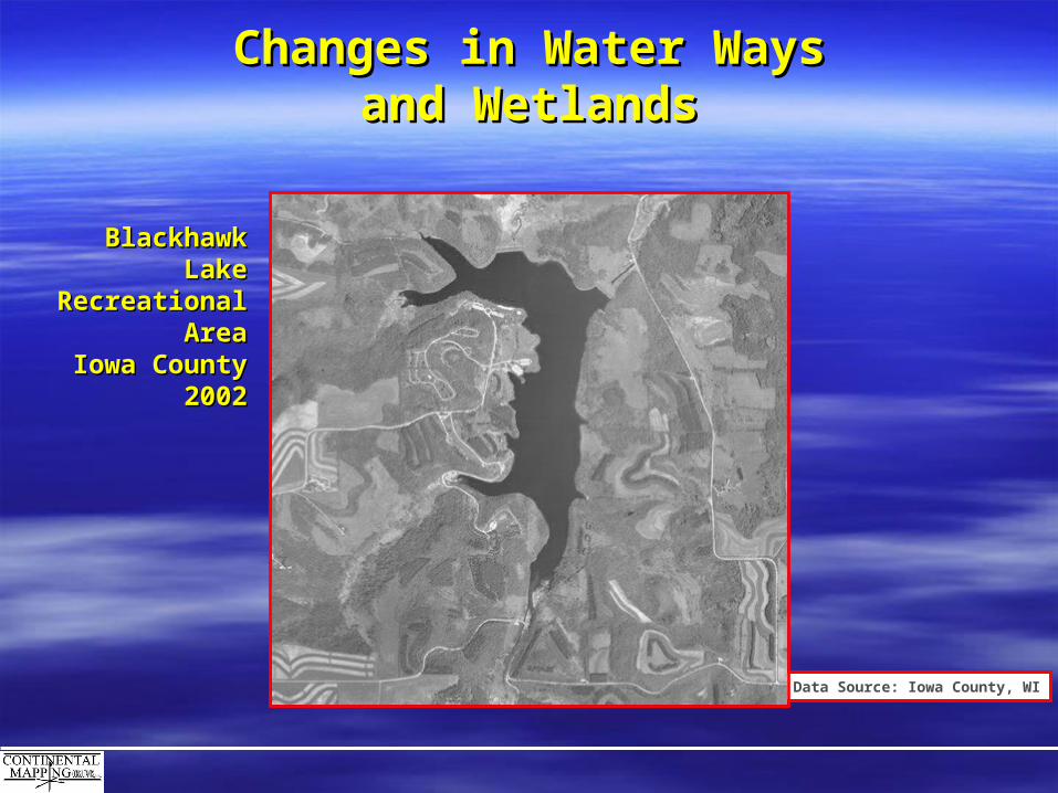
Changes in Water WaysChanges in Water Waysand Wetlandsand Wetlands
Data Source: Iowa County, WI
Blackhawk LakeBlackhawk LakeRecreational Recreational
AreaAreaIowa CountyIowa County
19681968
Changes in Water WaysChanges in Water Waysand Wetlandsand Wetlands
Data Source: Iowa County, WI
Blackhawk LakeBlackhawk LakeRecreational Recreational
AreaAreaIowa CountyIowa County
20022002

Changes in Water WaysChanges in Water Waysand Wetlandsand Wetlands
Data Source: Iowa County, WI
Blackhawk Lake Recreational Area, Iowa CountyBlackhawk Lake Recreational Area, Iowa County
2002200219681968

19701970
19801980
19901990
Review the past, predict the futureReview the past, predict the future
Data Source: Fond du Lac County, WI

Review the past, predict the futureReview the past, predict the future
1970 1970
19801980
19901990
Click Box to Change Year
Data Source: Fond du Lac County, WI

Review the past, predict the futureReview the past, predict the future
Data Source: Fond du Lac County, WI
1970 1970
19801980
19901990
Click Box to Change Year

Review the past, predict the futureReview the past, predict the future
Data Source: Fond du Lac County, WI
1970 1970
19801980
19901990
Click Box to Change Year

PHOTO RESEARCHPHOTO RESEARCH
1. Photo Source1. Photo Source•• Federal, State, Local ArchivesFederal, State, Local Archives
2. Important Photo Specifics2. Important Photo Specifics•• Type of Photography (Color, B&W, etc.)Type of Photography (Color, B&W, etc.)
•• Photo Scale (1” = 1667’ or 1:20,000 Typically Recommended)Photo Scale (1” = 1667’ or 1:20,000 Typically Recommended)
•• Season (Leaf-on, Leaf-off)Season (Leaf-on, Leaf-off)
3. Image Format3. Image Format•• Prints (Least Desirable)Prints (Least Desirable)
•• FilmFilm
•• DiapositivesDiapositives
•• Digital ScansDigital Scans
4. Scanning Capabilities4. Scanning Capabilities•• Available resolutionAvailable resolution
•• Flatbed or Photogrammetric ScannerFlatbed or Photogrammetric Scanner

ARCHIVAL RESEARCHARCHIVAL RESEARCH
1. Farm Services Agency (FSA): 1. Farm Services Agency (FSA): www.fsa.usda.govwww.fsa.usda.gov
2. US National Archives and Records Administration (NARA): 2. US National Archives and Records Administration (NARA): www.archives.govwww.archives.gov
3. USDA Aerial Photography Field Office (APFO): 3. USDA Aerial Photography Field Office (APFO): www.apfo.usda.govwww.apfo.usda.gov
4. USGS Earth Resources Observation Systems (EROS): 4. USGS Earth Resources Observation Systems (EROS): http://edc.usgs.govhttp://edc.usgs.gov
5. Wisconsin Department of Transportation (WISDOT): 5. Wisconsin Department of Transportation (WISDOT): www.dot.wisconsin.govwww.dot.wisconsin.gov
6. Wisconsin State Cartographers Office (SCO): 6. Wisconsin State Cartographers Office (SCO): www.geography.wisc.edu/sco/www.geography.wisc.edu/sco/
7. Regional Planning Commissions: 7. Regional Planning Commissions: www.commerce.state.wi.us/MT/MT-RPC-map.htmlwww.commerce.state.wi.us/MT/MT-RPC-map.html
8. Photogrammetric Consultants8. Photogrammetric Consultants
ARCHIVAL RESEARCHARCHIVAL RESEARCH
APFO (Aerial Photography Field Office- Salt Lake City, UT)APFO (Aerial Photography Field Office- Salt Lake City, UT)
USDA (US Department of Agriculture)USDA (US Department of Agriculture)
FSA (Farm Services Agency)FSA (Farm Services Agency)
Possesses 1”=1667’ (1:20,000) scale photography for all but 3 counties in Wisconsin.Possesses 1”=1667’ (1:20,000) scale photography for all but 3 counties in Wisconsin.
Years available: 1950’s through the 1980’s.Years available: 1950’s through the 1980’s.

ARCHIVAL RESEARCHARCHIVAL RESEARCH
NARA (National Archives - College Park, MD)NARA (National Archives - College Park, MD)
Agricultural Adjustment Agency (AAA) Photography. Precursor to the USDA.Agricultural Adjustment Agency (AAA) Photography. Precursor to the USDA.
MilitaryMilitary
Possesses 1”=1667’ (1:20,000) scale photography for most of Wisconsin.Possesses 1”=1667’ (1:20,000) scale photography for most of Wisconsin.
Years available: 1930’s through the 1950’s.Years available: 1930’s through the 1950’s.
DEFINE PRODUCTDEFINE PRODUCTThis will influence accuracy requirements, production strategies, andThis will influence accuracy requirements, production strategies, and
most importantly, cost.most importantly, cost.
Determine UsersDetermine Users
•• GIS personnelGIS personnel
•• Administrators/Policy MakersAdministrators/Policy Makers
•• PlannersPlanners
•• PublicPublic
Determine Purpose Determine Purpose
•• Visual AidVisual Aid
•• PlanningPlanning
•• Photo PreservationPhoto Preservation
•• Secure ArchivesSecure Archives
•• Space SavingSpace Saving

ESTIMATE ACQUISITION COSTESTIMATE ACQUISITION COST
APFO: 1” = 1667’ ScansAPFO: 1” = 1667’ Scans
Photo coverage Area = 4 miles.Photo coverage Area = 4 miles.
[Total Area of County (square miles) / 4] X $10.[Total Area of County (square miles) / 4] X $10.
Example: Average County = 778 square milesExample: Average County = 778 square miles
Images Needed: 778 / 4 = 194.5 (195) ImagesImages Needed: 778 / 4 = 194.5 (195) Images
Approximate Cost of Acquisition: 195 X $10 = $1950Approximate Cost of Acquisition: 195 X $10 = $1950

ESTIMATE ACQUISITION COSTESTIMATE ACQUISITION COST
National Archives: 1” = 1667’ ScansNational Archives: 1” = 1667’ Scans
Cost? Often difficult to Predict.Cost? Often difficult to Predict.
Pricing FactorsPricing Factors Limited Access to ArchivesLimited Access to Archives Scan resolution and file size determines cost per image.Scan resolution and file size determines cost per image. Bulk Rates Apply?Bulk Rates Apply? Research FeesResearch Fees Other add-on costs: Data Delivery, Flight Index, Price per Film Canister.Other add-on costs: Data Delivery, Flight Index, Price per Film Canister.

PART IIPART II
Production StrategiesProduction Strategies
presented by:presented by:
John EricksonJohn Erickson

RELATIVE ACCURACYRELATIVE ACCURACY
Accuracy of one point on an image with respectAccuracy of one point on an image with respectto the same point on another image.to the same point on another image.

POSITIONAL ACCURACYPOSITIONAL ACCURACY
Green Bay, WIGreen Bay, WI
19601960
Data Source: Brown County, WI
Accuracy of imagery as it relates to ground truth.Accuracy of imagery as it relates to ground truth.
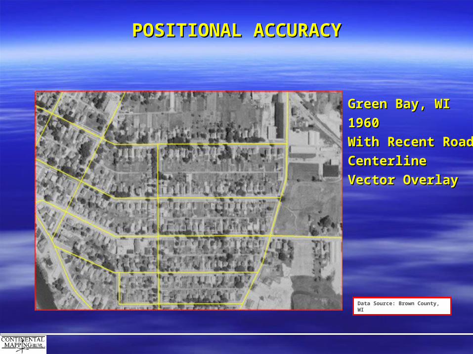
POSITIONAL ACCURACYPOSITIONAL ACCURACY
Green Bay, WIGreen Bay, WI
19601960
With Recent RoadWith Recent Road
CenterlineCenterline
Vector OverlayVector Overlay
Data Source: Brown County, WI

POSITIONAL ACCURACYPOSITIONAL ACCURACY
Data Source: Brown County, WI
Green Bay, WIGreen Bay, WI
19601960

POSITIONAL ACCURACYPOSITIONAL ACCURACY
Data Source: Brown County, WI
Green Bay, WIGreen Bay, WI
20002000
Courtesy ofCourtesy of
Brown Co LIOBrown Co LIO

ACCURACY DETERMINANTSACCURACY DETERMINANTS
Source Photo ScaleSource Photo Scale
Control Materials: vector, raster, or hardcopy dataControl Materials: vector, raster, or hardcopy data
Production StrategyProduction Strategy

THREE PRODUCTION STRATEGIESTHREE PRODUCTION STRATEGIES
1. Geo-referencing (2-D overlay) Historical Aerial Photography1. Geo-referencing (2-D overlay) Historical Aerial Photography
2. Historical Orthophotography2. Historical Orthophotography
3. Contemporary High Accuracy Orthophotography3. Contemporary High Accuracy Orthophotography

GEO-REFERENCINGGEO-REFERENCING
Referenced to existing Vector, Raster, or Hardcopy DataReferenced to existing Vector, Raster, or Hardcopy Data
Does not require stereo-coverage imageryDoes not require stereo-coverage imagery
Resampling Methods: Rubbersheeting, Affine, Best Fit, etc.Resampling Methods: Rubbersheeting, Affine, Best Fit, etc.
Low Positional and Relative AccuracyLow Positional and Relative Accuracy Lowest CostLowest Cost

HISTORICAL ORTHOPHOTOGRAPHYHISTORICAL ORTHOPHOTOGRAPHY
Surface ModelSurface Model
Control derived from existing Vector, Raster, or Hardcopy Control derived from existing Vector, Raster, or Hardcopy DataData
Does not require stereo-coverage imageryDoes not require stereo-coverage imagery
Good Relative and Positional AccuracyGood Relative and Positional Accuracy Lower-cost Orthophotography AlternativeLower-cost Orthophotography Alternative

CONTEMPORARY HIGH ACCURACY CONTEMPORARY HIGH ACCURACY ORTHOPHOTOGRAPHYORTHOPHOTOGRAPHY
Surface ModelSurface Model
AT (Aero-triangulation) or Direct Geo-referencingAT (Aero-triangulation) or Direct Geo-referencing
(Airborne GPS and IMU)(Airborne GPS and IMU)
Camera Calibration ReportCamera Calibration Report
Stereo-coverageStereo-coverage in most cases in most cases
High Relative and Positional AccuracyHigh Relative and Positional Accuracy Highest costHighest cost

UNDERSTAND LIMITATIONSUNDERSTAND LIMITATIONSThe final product cannot be better than the input.The final product cannot be better than the input.
Limitations of MaterialsLimitations of Materials
•• Condition of Historical PhotosCondition of Historical Photos
•• Photo Format (contact prints, film, diapositives)Photo Format (contact prints, film, diapositives)
•• Scan ResolutionScan Resolution
•• Quality and Accuracy of Referencing Materials Quality and Accuracy of Referencing Materials (control)(control)
•• Tone Balancing (difficult with older photography)Tone Balancing (difficult with older photography)
Budget ConstraintsBudget Constraints

RECENT EXAMPLES OF OUR WORKRECENT EXAMPLES OF OUR WORK
Brown County Land InformationBrown County Land Information
Jeff Dumez LIOJeff Dumez LIO
Historical OrthophotographyHistorical Orthophotography
1938: National Archives1938: National Archives Source Photography: 1”=1667’ (1:20,000) photo scale from filmSource Photography: 1”=1667’ (1:20,000) photo scale from film 210 Images Scanned at 15 Micron210 Images Scanned at 15 Micron Final Pixel Resolution = 1’.Final Pixel Resolution = 1’. Work in progress.Work in progress.
1960: APFO1960: APFO Source Photography: 1”=1667’ (1:20,000) photo scale from filmSource Photography: 1”=1667’ (1:20,000) photo scale from film 150 Images Scanned at 12.5 Micron150 Images Scanned at 12.5 Micron Final Pixel Resolution = 1’.Final Pixel Resolution = 1’. Positional Accuracy = 15’ - 20’Positional Accuracy = 15’ - 20’ Relative Accuracy = 5’ - 10’Relative Accuracy = 5’ - 10’

RECENT EXAMPLES OF OUR WORKRECENT EXAMPLES OF OUR WORK
Iowa County Land RecordsIowa County Land Records
Cristina PearsonCristina Pearson
Historical OrthophotographyHistorical Orthophotography
1968: APFO1968: APFO Source Photography: 1”=1667’ (1:20,000) photo scale from filmSource Photography: 1”=1667’ (1:20,000) photo scale from film 215 Images Scanned at 12.5 Micron215 Images Scanned at 12.5 Micron Final Pixel Resolution = 1’.Final Pixel Resolution = 1’. Positional Accuracy = 15’ - 20’Positional Accuracy = 15’ - 20’ Relative Accuracy = 5’ - 10’Relative Accuracy = 5’ - 10’

RECENT EXAMPLES OF OUR WORKRECENT EXAMPLES OF OUR WORK
Calumet County Planning and Land InformationCalumet County Planning and Land Information
Ken Pabich GIS/LIS SupervisorKen Pabich GIS/LIS Supervisor
Historical Geo-referencingHistorical Geo-referencing
1938: APFO and WisDOT1938: APFO and WisDOT Source Photography: 1”=1667’ (1:20,000) photo scale from film and printSource Photography: 1”=1667’ (1:20,000) photo scale from film and print 130 Images Scanned at 900 DPI130 Images Scanned at 900 DPI RubbersheetRubbersheet Final Pixel Resolution = 1’.Final Pixel Resolution = 1’. Positional Accuracy = Approx. 50’Positional Accuracy = Approx. 50’ Relative Accuracy = 30’ - 40’Relative Accuracy = 30’ - 40’

RECENT EXAMPLES OF OUR WORKRECENT EXAMPLES OF OUR WORK
Fond du Lac County Planning.Fond du Lac County Planning.
Terry DietzelTerry Dietzel
Historical Geo-referencingHistorical Geo-referencing
1970, 1980, and 19901970, 1980, and 1990 Source Photography: 1”=400’ (1:4,800) photo scale from Large Format Mylar PrintsSource Photography: 1”=400’ (1:4,800) photo scale from Large Format Mylar Prints 570 Images Scanned at 600 DPI570 Images Scanned at 600 DPI RubbersheetRubbersheet Positional Accuracy = Approx. 50’Positional Accuracy = Approx. 50’ Relative Accuracy = 30’ - 40’Relative Accuracy = 30’ - 40’

Review the past, predict the futureReview the past, predict the future
Data Source: Brown County, WI
19381938

Review the past, predict the futureReview the past, predict the future
Data Source: Brown County, WI
19601960

Review the past, predict the futureReview the past, predict the future
Data Source: Brown County, WI
20002000

Review the past, predict the futureReview the past, predict the future
Data Source: Brown County, WI
20002000 GOGOPACKPACKGO!GO!

19381938 19601960 20002000
QUESTIONSQUESTIONSGot Any ?Got Any ?
Visualize the past to assist in predicting the future.Visualize the past to assist in predicting the future.
Contact: Jason KruegerContact: Jason Krueger722 Lois Drive; Sun Prairie, WI; 53590722 Lois Drive; Sun Prairie, WI; 53590608-834-9823608-834-9823www.continentalmapping.comwww.continentalmapping.com