Embed Size (px)
Citation preview
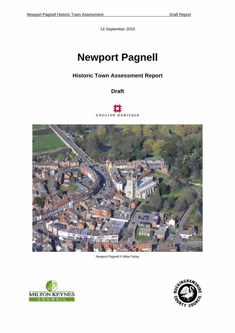
Newport Pagnell Historic Town Assessment Draft Report
14 September 2010
Newport Pagnell
Historic Town Assessment Report
Draft
Newport Pagnell © Mike Farley
Newport Pagnell Historic Town Assessment Draft Report 1
2
Summary .................................................................................................................................................. 4 I DESCRIPTION................................................................................................................................... 9 1 Introduction ...................................................................................................................................... 9
1.1 Project Background and Purpose ............................................................................................ 9 1.2 Aims ......................................................................................................................................... 9
2 Setting ............................................................................................................................................. 11 2.1 Location, Topography & Geology .......................................................................................... 11 2.2 Wider Landscape ................................................................................................................... 14
3 Brief History of Settlement............................................................................................................ 17 4 Evidence.......................................................................................................................................... 21
4.1 Historic Maps.......................................................................................................................... 21 4.2 Documentary Evidence .......................................................................................................... 21 4.3 Built Heritage.......................................................................................................................... 22 4.4 Archaeological Evidence........................................................................................................ 26 4.5 Environmental Evidence ........................................................................................................ 40
5 Archaeological & Historical Development................................................................................... 41 5.1 Prehistoric period (c.10,000 BC – AD 43).............................................................................. 41 5.2 Roman synthesis and components (AD 43 – 410) ................................................................ 43 5.3 Anglo Saxon synthesis and components (AD 410 – 1066) ................................................... 45 5.4 Medieval synthesis and components (1066-1536) ................................................................ 50 5.5 Post medieval synthesis and components (1536-1800) ........................................................ 58 5.6 Modern synthesis and components (1800-Present) .............................................................. 63
6 Historic Urban Zones..................................................................................................................... 73 6.1 Introduction............................................................................................................................. 73 6.2 Historic Urban Zones ............................................................................................................. 73 6.3 Archaeological Assessment ................................................................................................... 73 6.4 Period: .................................................................................................................................... 74 6.5 Survival:.................................................................................................................................. 75 6.6 Potential: ................................................................................................................................ 75 6.7 Group Value: .......................................................................................................................... 75 6.8 Diversity:................................................................................................................................. 75 6.9 Historic Settlement ................................................................................................................. 77 6.10 Modern Settlement................................................................................................................. 85
II ASSESSMENT............................................................................................................................. 89 7 Summary and Potential ................................................................................................................. 89
7.1 Conservation Areas (CA) ....................................................................................................... 91 7.2 Scheduled Ancient Monuments (SAMs) ................................................................................ 91 7.3 Historic Character .................................................................................................................. 91 7.4 Archaeological Potential......................................................................................................... 91
III RESEARCH AGENDA................................................................................................................. 92 8 Research Agenda ........................................................................................................................... 92 9 References ...................................................................................................................................... 94
9.1 Map Sources .......................................................................................................................... 94 9.2 Trade Directories.................................................................................................................... 94 9.3 Bibliography............................................................................................................................ 94 9.4 Websites................................................................................................................................. 98
10 Addresses ................................................................................................................................... 98 11 Appendix 1: Chronology & Glossary of Terms ..................................................................... 100
11.1 Chronology (taken from Unlocking Buckinghamshire’s Past Website)................................ 100 11.2 Glossary of Terms................................................................................................................ 100
12 Appendix 2: HER Records ....................................................................................................... 102 12.1 Monuments HER Report ...................................................................................................... 102 12.2 Landscapes HER Reports.................................................................................................... 106 12.3 Find Spots ............................................................................................................................ 106 12.4 Listed Buildings .................................................................................................................... 109
13 Appendix 3: Trade Listings and Population Data ................................................................. 113 14 Appendix 4: Historical Consultancy Report .......................................................................... 115
Newport Pagnell Historic Town Assessment Draft Report 1
3
List of Illustrations
Figure 1: Urban Character Zones for Newport Pagnell ............................................................................. 6 Figure 2: Newport Pagnell in location...................................................................................................... 10 Figure 3: Geology of town (BGS) ............................................................................................................ 12 Figure 4: Diagram of Connections from Newport Pagnell (representational only).................................. 13 Figure 5: Town in the wider historic landscape using routes and Bucks HLC ........................................ 15 Figure 6: Settlement around Newport Pagnell ........................................................................................ 16 Figure 7: Graph showing population changes in Newport Pagnell (excluding 1941, 1981 & 1991) ....... 18 Figure 8: Town in the 1880s to 1920s ..................................................................................................... 19 Figure 9: The town in the post war to modern period.............................................................................. 20 Figure 10: 1644 plan of Newport Pagnell by C. Vandenboome. ............................................................. 21 Figure 11: Listed Buildings in Newport Pagnell by century ..................................................................... 22 Figure 12: Historic maps from Clockwise: Thomas Jefferys’s Map depicting Newport Pagnell c. 1760s; OS Surveyor’s Map c.1810;. Plan of Tickford Brook 1620s; Enclosure Map of Portfield 1795; Tickford 1808......................................................................................................................................................... 23 Figure 13: Listed Buildings in Newport Pagnell....................................................................................... 24 Figure 14: Location and extent of events in Newport Pagnell and surrounding the town....................... 25 Figure 15: HER records for the Prehistoric period .................................................................................. 42 Figure 16: HER records for the Roman period........................................................................................ 44 Figure 17: Possible extent of the town in the Saxon period .................................................................... 48 Figure 18: Possible extent of the town in the Saxon period .................................................................... 49 Figure 19: St Peter and Paul Church ...................................................................................................... 52 Figure 20: The remains of Tickford Priory, an illustration by the antiquarian Browne Willis c. 1723 ...... 54 Figure 21: Medieval arrangement of open fields and deer park in Newport Pagnell .............................. 55 Figure 22: Timber framed jettied buildings, 16 to 18 Silver Street showing later under-building beneath the jetties extending the building forwards, ............................................................................................. 56 Figure 23: Possible extent of the town in the medieval period................................................................ 57 Figure 24: 38 High Street Newport Pagnell............................................................................................. 61 Figure 25: Probable extent of the late post medieval town ..................................................................... 62 Figure 26: Newport Mill c. 1880 - 1899 ................................................................................................... 63 Figure 27: Salmon chassis workshop, Tickford....................................................................................... 65 Figure 28: Tickford Bridge ....................................................................................................................... 67 Figure 29: Newport Pagnell Board School .............................................................................................. 69 Figure 30: 1970s housing Milton Drive.................................................................................................... 70 Figure 31: Character of the town and architectural styles....................................................................... 71 Figure 32: Morphological and period development ................................................................................. 72 Figure 33: Diagram showing the process involved in the creation of the urban character zones........... 74 Figure 34: Historic Character Zones for Newport Pagnell....................................................................... 76 Figure 35: Extent of the conservation area, 2009 ................................................................................... 90
Table 1: Checklist for Newport Pagnell ..................................................................................................... 8 Table 2: Quantities of Saxo-Norman pottery sherds found in Newport Pagnell...................................... 46 Table 3: Quantities of medieval pottery sherds found in Newport Pagnell historic town (Source: MK HER) ........................................................................................................................................................ 52 Table 4: The number of interments in the register of burials for the year 1666 (from Sheahan 1861) .. 59 Table 5: Recorded Inns and Taverns in the Post medieval period (Mynard & Hunt 1995)..................... 60 Table 6: Summary of trade in Newport Pagnell 1830-1935 (method adapted from Broad, 1992).......... 64
Newport Pagnell Historic Town Assessment Draft Report 1
4
Summary
This report written as part of the Buckinghamshire Historic Towns Project is intended to summarise the archaeological, topographical, historical and architectural evidence relating to the development of Newport Pagnell in order to provide an informed basis for conservation, research and the management of change within the urban environment. Emphasis is placed on identifying a research agenda for the town and on a semi-quantitative method for defining local townscape character. The Historic Towns methodology complements the well-established process of conservation area appraisal by its complete coverage, greater consideration of time-depth and emphasis on research potential. Each Buckinghamshire Historic Towns Project report includes a summary of information for the town including key dates and facts. The project forms part of an extensive historic and natural environment characterisation programme by Buckinghamshire County Council.
Newport Pagnell is acknowledged as being one of Buckinghamshire’s most prominent market towns although its origins remain obscure. There is a lack of documentary evidence prior to the Domesday survey although there is some indication that Newport was an established town in the Anglo-Saxon period. Together with Buckingham it is one of the earliest towns in the county referred to in the Domesday Book as a borough. The uncertainty over Newport’s early origins has led to some debate over its original foundation. Whether Newport grew as a principal market place exploiting its position on the rivers and trade routes or perhaps founded as a strategic outpost - an Anglo Saxon burh, established on the frontier with the Danish held lands to the north in the 9th or 10th century.
By the 12th century, Newport’s manor came under the ownership of Fulk Paynel, whose legacy to the town was not just to provide it with its suffix, but also to bestow land at Tickford to the monks of the Cluniac Abbey of Marmoutier, Tours who established a Priory there. The manor also possessed a deer park which was located to the west of Tickford. Later in the 12th century Newport passed to the de Someries family who contributed to the development of the town by building a castle, although the exact location is unknown. Two medieval hospitals were also founded in the town: St John’s hospital at Tickford Bridge and a leper hospital of St Margaret believed to be sited to the north of the town outside the parish boundary.
Perhaps the most important influence on the town was its market function. Newport’s strategic position on major routes enabled it to provide a wide variety of goods and services without depending on one major source of revenue. It also became known as a ‘thoroughfare town’, a popular resting point for travellers and traders, including monarchs King John in 1204 and Henry III in 1224. As a consequence a number of inns grew up around the principal streets.
Newport’s geographical and strategic importance was reflected during the Civil War when the town was fortified firstly by the Royalist and then the Parliamentarians. Substantial bank and ditch defences were constructed around the town, although little physical evidence of these fortifications survives today. The only extant remains are earthworks found in Bury Field which are designated as a Scheduled Ancient Monument.
From the 17th to 19th centuries Newport was renowned for its involvement in the lace
Newport Pagnell Historic Town Assessment Draft Report 1
5
trade, many lace dealers and traders basing their operations in the town. By the 18th century it was believed that Newport was one of the most productive towns in England. This brought wealth to the town and many fine houses were built along the High Street from the proceeds of lace making. There are also other notable industries associated with Newport including tanning and leather making for the town’s costermongers while fellmongering took place along the river at Tickford, providing much of the parchment used in the lace making process.
Communications and transportation have always been vital for the existence of Newport, and the town benefited from foundation of turnpike trusts in the 18th and early 19th centuries. The improvements to roads increased trade and by the 1820s up to 30 coaches stopped at Newport each day. One of the defining features of the town is Tickford Bridge crossing the river Lovat, which was built in 1810 and is one of a handful of iron bridges in Britain still carrying main road traffic. The town was also connected to the canal network when the Newport branch off the Grand Junction Canal opened in 1817. However, the canal was never profitable and was eventually superseded by the Newport Pagnell to Wolverton railway which operated from 1868 to 1964.
Even in the 20th century Newport Pagnell still maintained its link to transportation. The town possessed the Salmon coach and carriage works at Tickford which had operated since the 19th century, this successfully adapted to become a centre of car manufacturing in the 1920s. The works were eventually taken over by Aston Martin who established their Lagonda factory at Tickford from 1950 to 2007. Perhaps the biggest impacts to affect the town occurred in the latter half of the 20th century: The M1 motorway opened in the 1950s, Newport Pagnell also had the accolade of being the location of Britain’s first motorway service station. The other major event was the planning and construction of the new city of Milton Keynes in the 1960s and 1970s, a knock on effect was the rapid growth of the town with the construction of housing estates. Although currently part of Milton Keynes, Newport Pagnell has maintained its status as an important local centre in North East Buckinghamshire
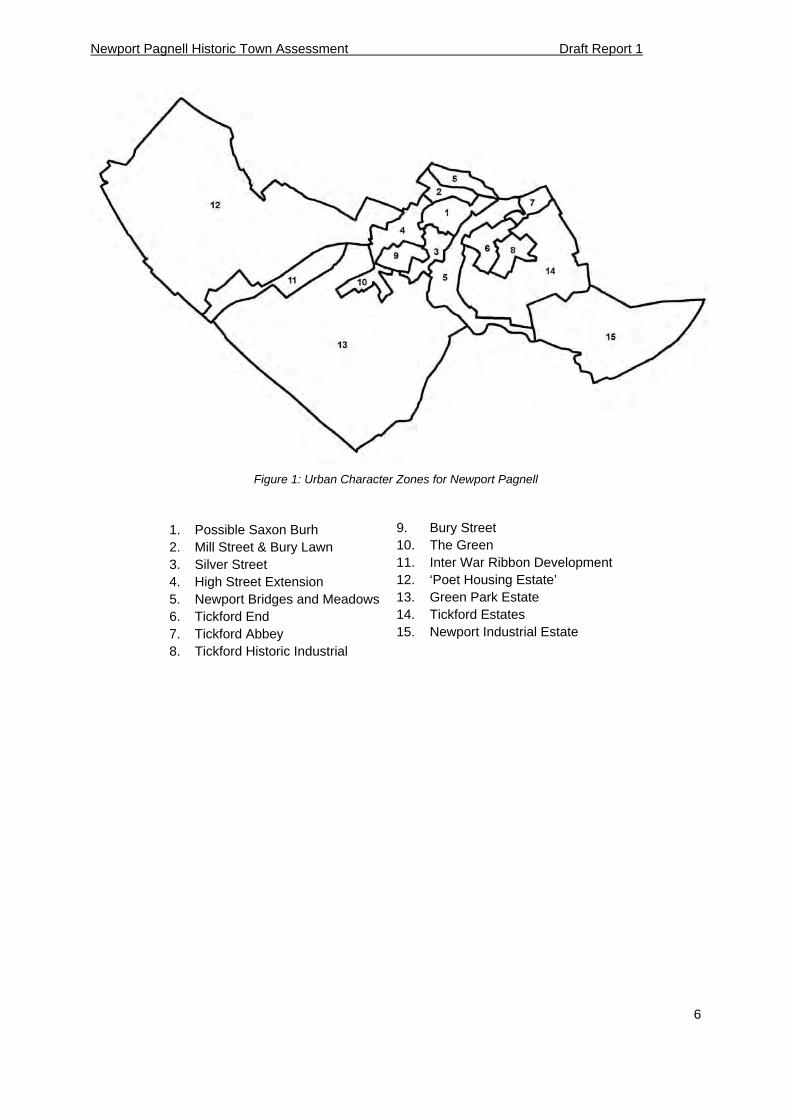
The culmination of this report is the production of a series of historic urban zones that can be used to indicate areas of known archaeological potential; areas that may benefit from more detailed archaeological or documentary research and areas with limited known archaeological potential.
Zones one to six have the most archaeological potential for the Iron Age, Saxon to medieval period, further investigation in these areas may help identify Saxon settlement in the town. Zone seven may have a high potential for prehistoric and Roman archaeology. Zone eight may also have a high potential for Post Medieval archaeology, relating to Newport Pagnell’s involvement in the automotive industry.
Newport Pagnell Historic Town Assessment Draft Report 1
6
Figure 1: Urban Character Zones for Newport Pagnell
1. Possible Saxon Burh 9. Bury Street
2. Mill Street & Bury Lawn 10. The Green
3. Silver Street 11. Inter War Ribbon Development
4. High Street Extension 12. ‘Poet Housing Estate’
5. Newport Bridges and Meadows 13. Green Park Estate
6. Tickford End 14. Tickford Estates
7. Tickford Abbey 15. Newport Industrial Estate
8. Tickford Historic Industrial
Newport Pagnell Historic Town Assessment Draft Report 1
7
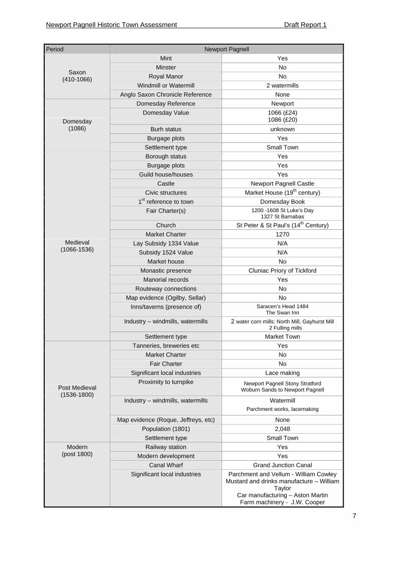
Period Newport Pagnell
Mint Yes
Minster No
Royal Manor No
Windmill or Watermill 2 watermills
Saxon (410-1066)
Anglo Saxon Chronicle Reference None
Domesday Reference Newport
Domesday Value 1066 (£24) 1086 (£20)
Burh status unknown
Burgage plots Yes
Domesday (1086)
Settlement type Small Town
Borough status Yes
Burgage plots Yes
Guild house/houses Yes
Castle Newport Pagnell Castle
Civic structures Market House (19th century)
1st reference to town Domesday Book
Fair Charter(s) 1200 -1608 St Luke’s Day 1327 St Barnabas
Church St Peter & St Paul’s (14th Century)
Market Charter 1270
Lay Subsidy 1334 Value N/A
Subsidy 1524 Value N/A
Market house No
Monastic presence Cluniac Priory of Tickford
Manorial records Yes
Routeway connections No
Map evidence (Ogilby, Sellar) No
Inns/taverns (presence of) Saracen’s Head 1484 The Swan Inn
Industry – windmills, watermills 2 water corn mills: North Mill, Gayhurst Mill 2 Fulling mills
Medieval (1066-1536)
Settlement type Market Town
Tanneries, breweries etc Yes
Market Charter No
Fair Charter No
Significant local industries Lace making
Proximity to turnpike Newport Pagnell Stony Stratford Woburn Sands to Newport Pagnell
Industry – windmills, watermills Watermill Parchment works, lacemaking
Map evidence (Roque, Jeffreys, etc) None
Population (1801) 2,048
Post Medieval (1536-1800)
Settlement type Small Town
Railway station Yes
Modern development Yes
Canal Wharf Grand Junction Canal
Modern (post 1800)
Significant local industries Parchment and Vellum - William Cowley Mustard and drinks manufacture – William
Taylor Car manufacturing – Aston Martin Farm machinery - J.W. Cooper

Newport Pagnell Historic Town Assessment Draft Report 1
8
Tanneries, breweries etc Yes
Population (2001) 15,020
Settlement type
Table 1: Checklist for Newport Pagnell
Newport Pagnell Historic Town Assessment Draft Report 1
9
I DESCRIPTION
1 Introduction
1.1 Project Background and Purpose
The Buckinghamshire Historic Towns Project forms part of a national programme of projects funded by English Heritage (EH) based on the archaeology, topography and historic buildings of England’s historic towns and cities.
This Historic Settlement Assessment Report for Newport Pagnell has been prepared by the Buckinghamshire County Archaeological Service as part of the Buckinghamshire Historic Towns Project to inform and advise the planning process. This report has been compiled using a number of sources, including the Milton Keynes Historic Environment Record (HER), the List of Buildings of Architectural and Historical Interest and selected historical cartographic and documentary records. Site visits were also made to classify the character of the built environment. The preparation of this report has involved the addition of information to the database and the digitising of spatial data onto a Geographic Information System (GIS). In addition, this report presents proposals for the management of the historic settlement archaeological resource.
1.2 Aims
The overall aim of the project is to inform management of the historic environment within Buckinghamshire’s urban areas. Specifically, it will:
Improve the quality and environmental sensitivity of development by enhancing the consistency, efficiency and effectiveness of the application of Planning Policy Guidance 15 and 16 covering the historic environment and archaeology respectively.
Inform the preparation and review of conservation area appraisals
Where appropriate, assist with the development of Town Schemes and urban regeneration projects
Inform Local Development Frameworks, especially in the recognition of historic townscape character
Act as a vehicle for engaging local communities by promoting civic pride and participation in local research and conservation projects.
Build upon the original Historic Landscape Characterisation (HLC) for Buckinghamshire (completed in 2005) through the addition of more detailed characterisation of the urban environment.
Address an agenda recognised in the Solent Thames Research Frameworks for Buckinghamshire (2006) regarding a lack of knowledge of the built environment and in particular the need for research into land use continuity and internal planning within Buckinghamshire’s early towns.
Newport Pagnell Historic Town Assessment Draft Report 1
10
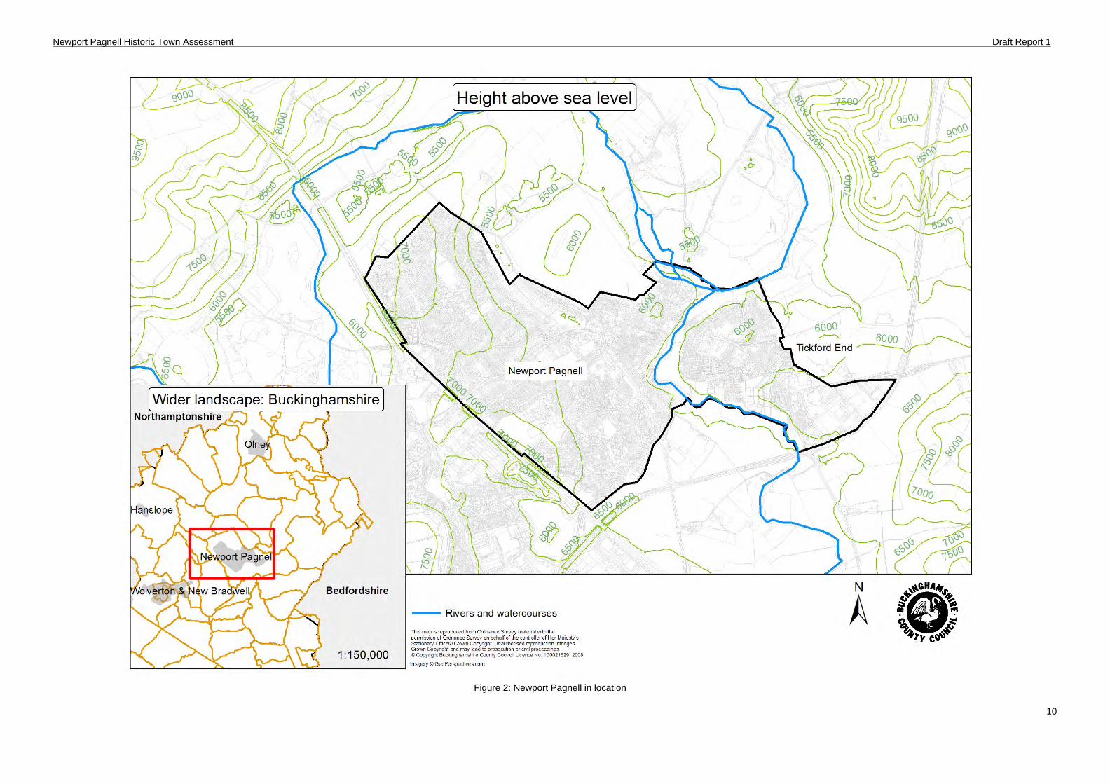
Figure 2: Newport Pagnell in location
Newport Pagnell Historic Town Assessment Draft Report 1
11
2 Setting
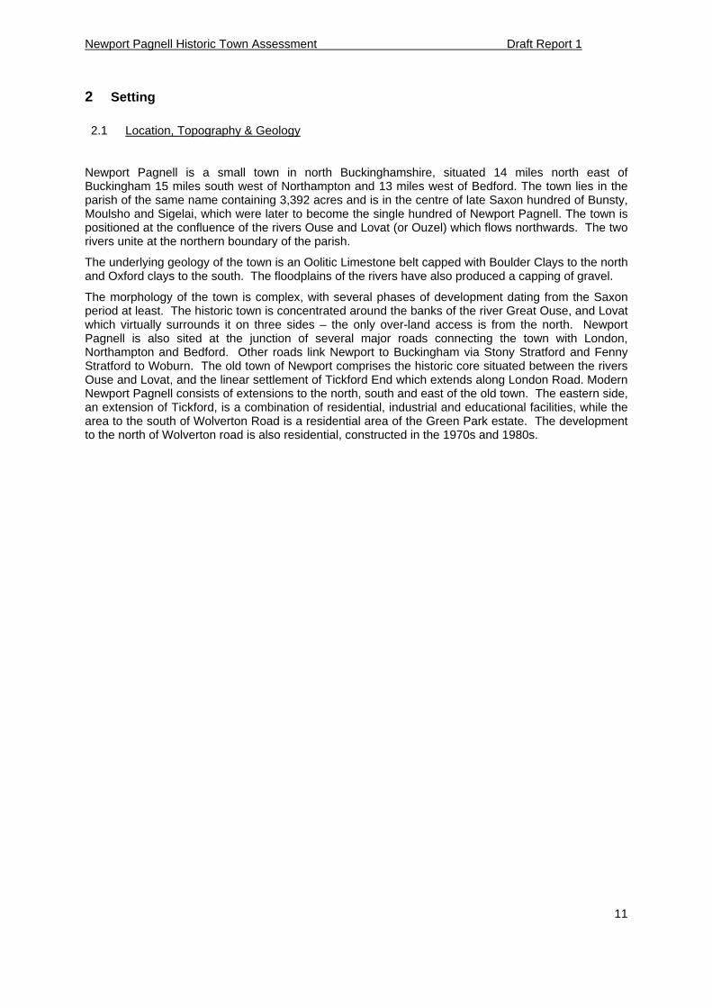
2.1 Location, Topography & Geology
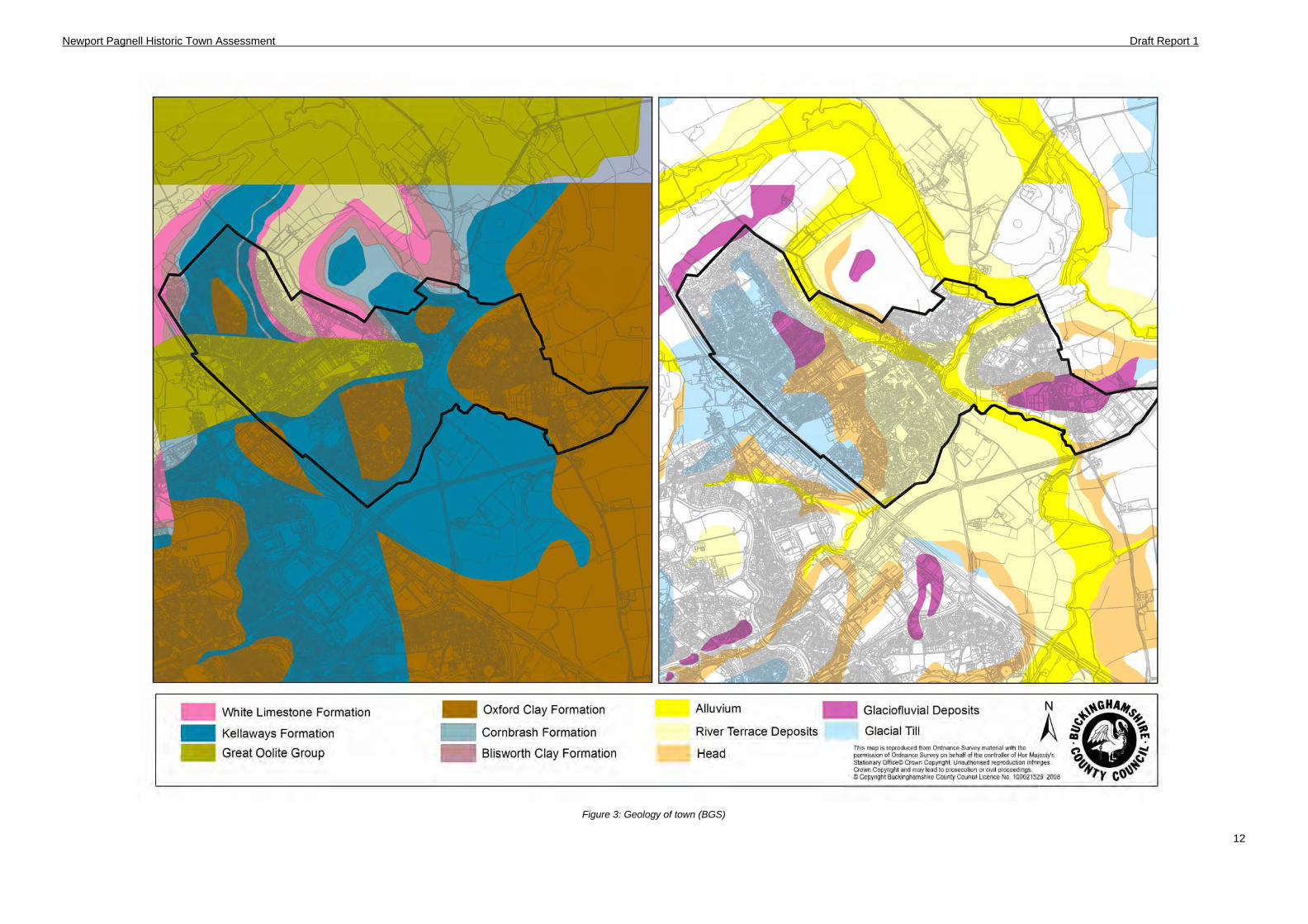
Newport Pagnell is a small town in north Buckinghamshire, situated 14 miles north east of Buckingham 15 miles south west of Northampton and 13 miles west of Bedford. The town lies in the parish of the same name containing 3,392 acres and is in the centre of late Saxon hundred of Bunsty, Moulsho and Sigelai, which were later to become the single hundred of Newport Pagnell. The town is positioned at the confluence of the rivers Ouse and Lovat (or Ouzel) which flows northwards. The two rivers unite at the northern boundary of the parish.
The underlying geology of the town is an Oolitic Limestone belt capped with Boulder Clays to the north and Oxford clays to the south. The floodplains of the rivers have also produced a capping of gravel.
The morphology of the town is complex, with several phases of development dating from the Saxon period at least. The historic town is concentrated around the banks of the river Great Ouse, and Lovat which virtually surrounds it on three sides – the only over-land access is from the north. Newport Pagnell is also sited at the junction of several major roads connecting the town with London, Northampton and Bedford. Other roads link Newport to Buckingham via Stony Stratford and Fenny Stratford to Woburn. The old town of Newport comprises the historic core situated between the rivers Ouse and Lovat, and the linear settlement of Tickford End which extends along London Road. Modern Newport Pagnell consists of extensions to the north, south and east of the old town. The eastern side, an extension of Tickford, is a combination of residential, industrial and educational facilities, while the area to the south of Wolverton Road is a residential area of the Green Park estate. The development to the north of Wolverton road is also residential, constructed in the 1970s and 1980s.
Newport Pagnell Historic Town Assessment Draft Report 1
12
Figure 3: Geology of town (BGS)
Newport Pagnell Historic Town Assessment Draft Report 1
13
Figure 4: Diagram of Connections from Newport Pagnell (representational only)
Newport Pagnell Historic Town Assessment Draft Report 1
14
2.2 Wider Landscape
Transport and Communication
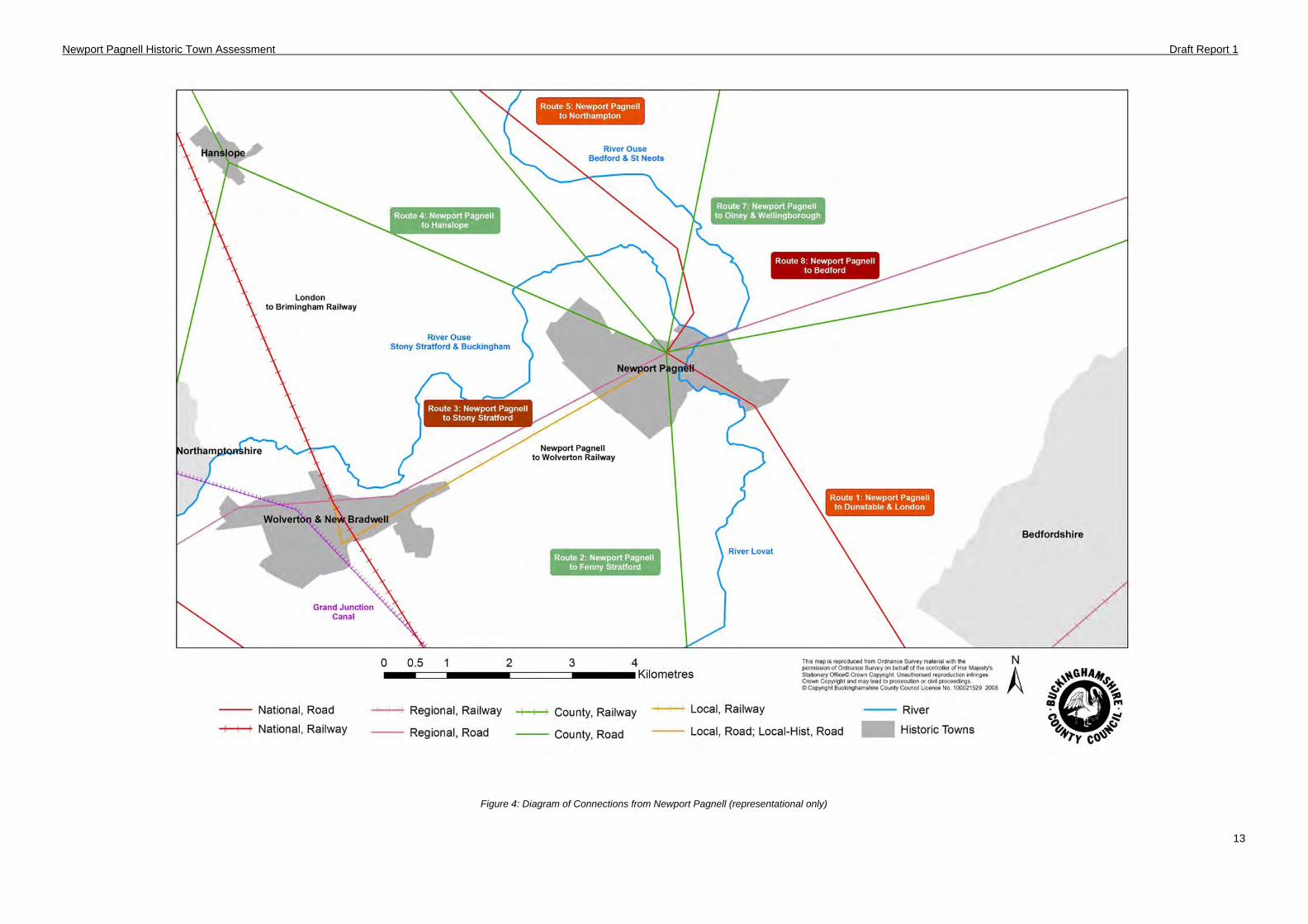
The basic framework of routes around Newport Pagnell dates to the Saxon times at least. The town serves as a major junction between several routes leading to other nationally or regionally important towns in the Anglo Saxon and medieval period such as Northampton, Bedford, Stony and Fenny Stratford, and Wellingborough.
Other routes from Olney, Stony Stratford, and Dunstable also lead to Newport Pagnell with the market place as the principal junction. The only routes from Newport Pagnell that served a purely local purpose were the minor roads linking the town.
The rivers Lovat and Great Ouse pass through Newport Pagnell, the Ouse meanders through the British countryside from its origin at Syresham in Northamptonshire for 150 miles until it enters the Wash at Kings Lynn in Norfolk. Along its path are a number of important settlements including Brackley, Buckingham, Stony Stratford, Bedford, St Neots, St Ives and Ely many of which probably owe their location to the river, at least in part.
A branch of the Grand Union canal was established in the early 19th century but soon closed after the competition with the railways. Newport eventually gained a link to the railway network in the late 19th century through the construction of the Wolverton to Newport Pagnell branch line by the London and North Western Railway. The railway largely followed the course of the infilled canal and continued in use until its closure in the 1960s.
Rural Landscape
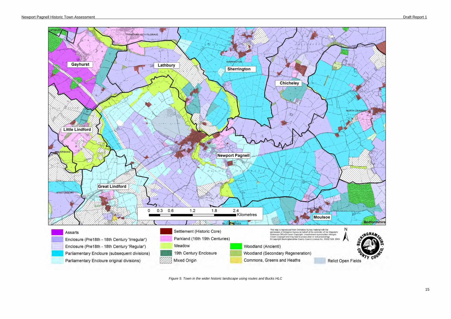
The landscape around Newport Pagnell is mainly comprised of parliamentary enclosure fields which replaced an open field landscape in the late 18th early 19th century. There are two Enclosure awards for the parish: Port Field was enclosed in 1795 while a second Act of 1807 enclosed Tickford Field (Figure 5). In addition to the planned fields, Newport’s landscape is also characterised by the older, sinuous shaped fields of meadows which flank the Ouse and Lovat rivers, while the open expanse of Bury Field has long been the common land for the residence of the borough.
Newport Pagnell Historic Town Assessment Draft Report 1
15
Figure 5: Town in the wider historic landscape using routes and Bucks HLC
Newport Pagnell Historic Town Assessment Draft Report 1
16
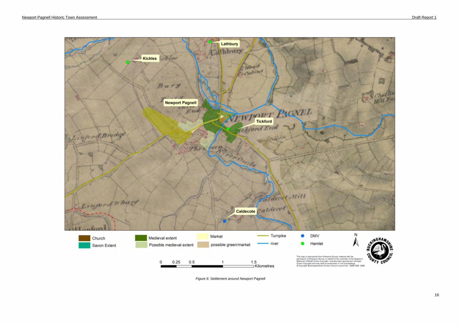
Figure 6: Settlement around Newport Pagnell
Newport Pagnell Historic Town Assessment Draft Report 1
17
3 Brief History of Settlement
The town was first mentioned in the Domesday Book of 1086 as Neuport, which is Old English meaning New Market Town. (Mawer & Stenton, 1925). The suffix "Pagnell" came later, when the manor passed into the hands of the Pagnell (Paynel) family.
Anglo Saxon
There is some speculation about the origins of Newport Pagnell but it is thought that the town and its status as a borough was well established by the late Anglo Saxon period, although its organisation and nature has been the subject of some debate (Robinson 1974). Located on the junction of two rivers it has been hypothesised that Newport was a frontier town during the Anglo Danish wars and evolved out of trade routes from Northampton to London both of which were under Viking control. There is added speculation that the formation of the town was a defensive burh taking advantage of drainage and topography (see 5.3 ).
Medieval (1066 -1536)
After the Conquest the town passed into the ownership of William fitz Ansculf. The manor and honour then passed to the Paynel family in the 12th century under whose patronage a Cluniac Priory at Tickford was founded and through this the town grew in importance. The Paynels are also believed to have built a castle but its location and existence has long been questioned. The town also possessed a weekly market and an annual fair which was first recorded in documentation by the 13th century, although it is thought that they were long established by this date. The markets flourished as the town is well positioned on a network of prominent routes including the road from London to Northampton. Two medieval hospitals were also founded in the town, St John’s hospital near Tickford bridge and thought to be founded before 1240 and St. Margaret's hospital, of which little is known although the phrase ‘without Newport Pagnell’ suggests that that this hospital stood on the north side of the north bridge just outside the borough (Robinson 1975).
Post Medieval (1536 – 1800)
The priory at Tickford was dissolved in 1542 and given to Cardinal Wolsey to endow his college at Oxford. The loss of the priory would have been detrimental to the town although there are no records to reflect the downturn in trade or fortune.
The next episode in Newport Pagnell’s history is the Civil War which had a profound impact upon the town. Newport was first a Royalist stronghold, although an engagement saw the abandonment of the town to Parliamentary forces. Being of strategic importance in the war, the parliamentarians took the opportunity to fortifying the town with earthworks, some of which can still be seen on the town Common, Bury Field. A map of the fortifications was produced in 1644 and depicts the elaborate defences. At that time there were buildings in the middle of the High Street (the town shambles) and it was here that the Parliamentary forces had their headquarters close to the Swan Inn.
Newport Pagnell was at one time the centre of the lace industry, but it was through its importance as a transport centre that the town grew, being on direct routes between Leicester and London and Cambridge and Oxford. By the late 17th century over 180 goods and coach services a week passed through the town and it was well provided with coaching inns. Such was the importance of the coaching trade to the town that the Iron Tickford Bridge and the stone North Bridges were built in 1810 to cater for the heavy traffic.
Modern (1800 – Present)
From the 19th century to the beginning of the 20th century Newport Pagnell grew modestly in both extent and population. The coming of the branch of the Grand Union Canal in 1817 reduced the reliance on road traffic for heavy goods, but the railways heralded the decline of coaches and narrow boats. The waterway link had already fallen into disuse and been largely backfilled when the branch railway line from Wolverton was opened in 1865.
Newport’s good transport links and its proximity to a water supply enabled the establishment of a number of small industries and businesses. One of the earliest was a costermonger which grew up out of the lace industry, providing parchment for the workers. William Cowley & Co’s
Newport Pagnell Historic Town Assessment Draft Report 1
18
parchment works still survives and is one of the last of its kind in Britain. Newport also had the Taylor’s Mustard Works in Union Street, which opened in 1830 and also produced sodawater, lithium water and seltzers. The factory operated until 1990 when it relocated to Cheshire.
The town also possessed a coachworks, owned by Salmons & Sons and was a focal point for the local farming industry. To some extent Newport was a dormitory for workers at the railway works at Wolverton (Mynard & Hunt 1995). The town was affected by economic recession in the late 19th century and for two decades the census returns show a decline in the population. Newport diversified at the beginning of the 20th century becoming the site of a car manufacturing plant for Aston Martin Lagonda Ltd. (AML) and W.J. Cooper’s tractor & farm machinery works. Aston Martin was established in the 1950s at the plant at Tickford and became Newport’s most famous company until its closure (apart from the servicing wing) in 2007. Cooper’s Phoenix works located at the old brewery operated until the late 1980s when operations were moved to Gawcott.
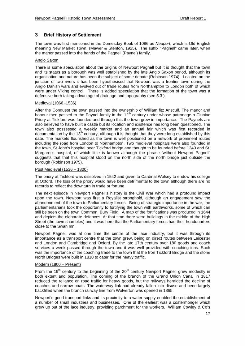
By the mid to latter end of the 20th century the town underwent major expansion with big housing estates were built to the west and to the south of the old town, Newport’s population more than doubled from 6,336 in 1971 to over 16,000 in 2001 (figure 6). A catalyst for this growth can be attributed to the creation of the new town of Milton Keynes and construction of the M1 motorway. Despite these developments having a profound effect upon the town, the motorway has to some degree acted as a bulwark against further expansion of Milton Keynes. Newport Pagnell’s proximity to Milton Keynes and major transport routes has revived its fortunes as an economic base with new businesses established around the town.
0
2000
4000
6000
8000
10000
12000
14000
16000
1801
1811
1821
1831
1841
1851
1861
1871
1881
1891
1901
1911
1921
1931
1941
1951
1961
1971
1981
1991
2001
Figure 7: Graph showing population changes in Newport Pagnell (excluding 1941, 1981 & 1991)
Newport Pagnell Historic Town Assessment Draft Report 1
19
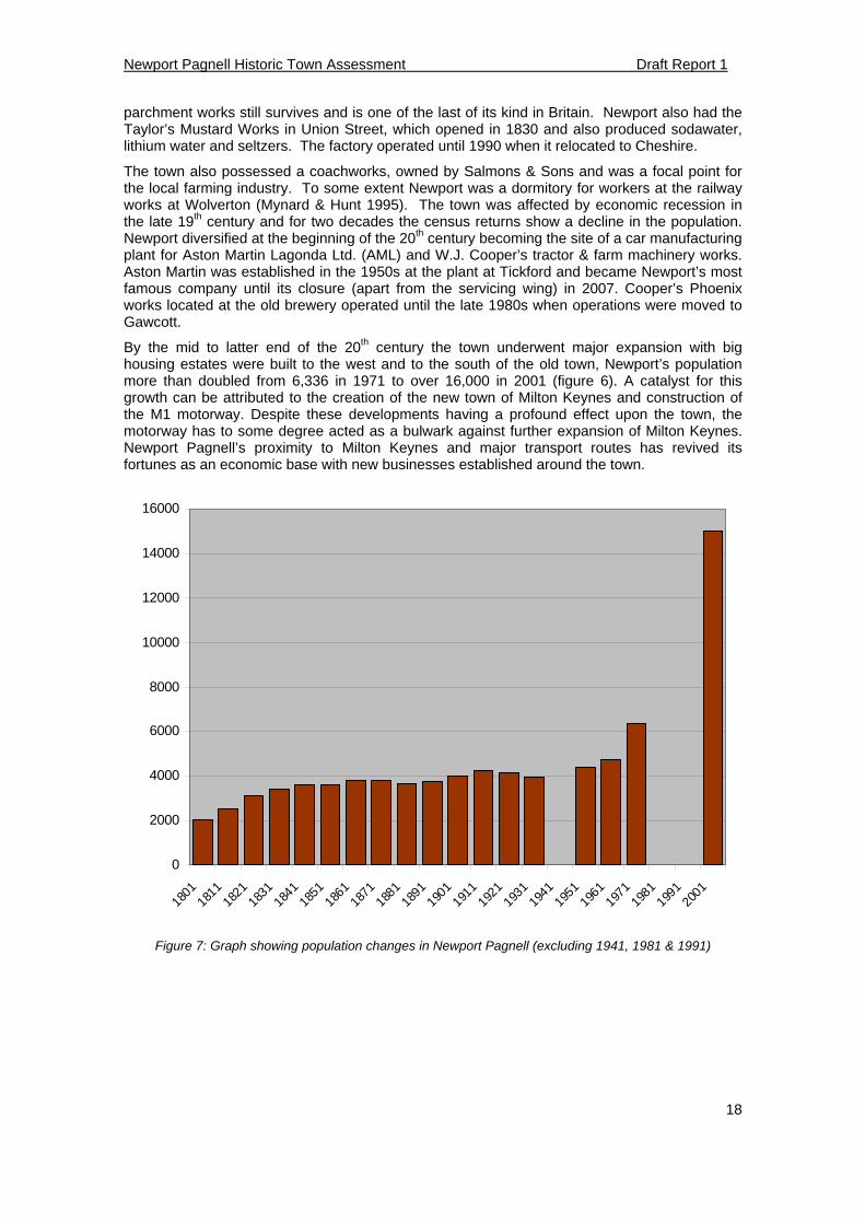
Figure 8: Town in the 1880s to 1920s
Newport Pagnell Historic Town Assessment Draft Report 1
20
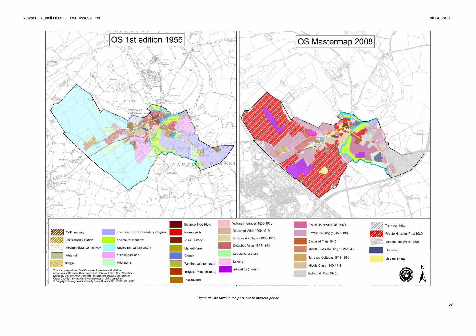
Figure 9: The town in the post war to modern period
Newport Pagnell Historic Town Assessment Draft Report 2
21
4 Evidence
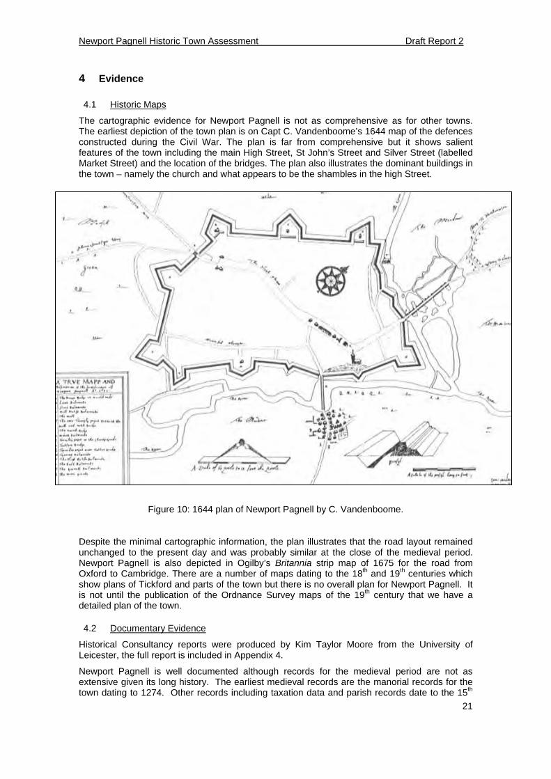
4.1 Historic Maps
The cartographic evidence for Newport Pagnell is not as comprehensive as for other towns. The earliest depiction of the town plan is on Capt C. Vandenboome’s 1644 map of the defences constructed during the Civil War. The plan is far from comprehensive but it shows salient features of the town including the main High Street, St John’s Street and Silver Street (labelled Market Street) and the location of the bridges. The plan also illustrates the dominant buildings in the town – namely the church and what appears to be the shambles in the high Street.
Figure 10: 1644 plan of Newport Pagnell by C. Vandenboome.
Despite the minimal cartographic information, the plan illustrates that the road layout remained unchanged to the present day and was probably similar at the close of the medieval period. Newport Pagnell is also depicted in Ogilby’s Britannia strip map of 1675 for the road from Oxford to Cambridge. There are a number of maps dating to the 18th and 19th centuries which show plans of Tickford and parts of the town but there is no overall plan for Newport Pagnell. It is not until the publication of the Ordnance Survey maps of the 19th century that we have a detailed plan of the town.
4.2 Documentary Evidence
Historical Consultancy reports were produced by Kim Taylor Moore from the University of Leicester, the full report is included in Appendix 4.
Newport Pagnell is well documented although records for the medieval period are not as extensive given its long history. The earliest medieval records are the manorial records for the town dating to 1274. Other records including taxation data and parish records date to the 15th
Newport Pagnell Historic Town Assessment Draft Report 2
22
and 16th centuries. Records from the post medieval and modern periods survive in greater quantities. The main secondary sources for Newport Pagnell are included in the bibliography.
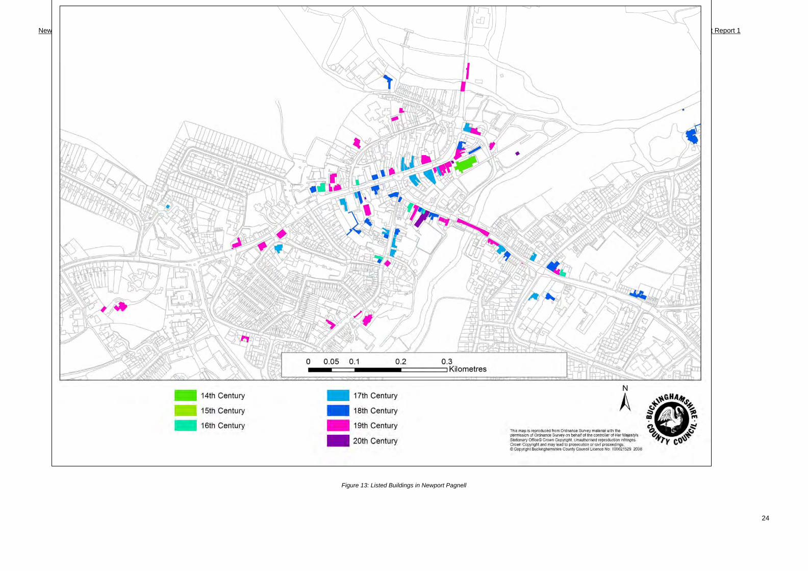
4.3 Built Heritage
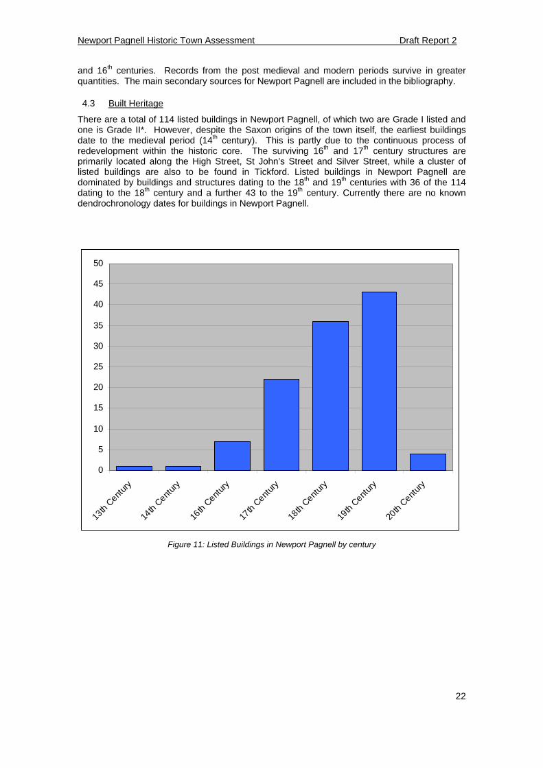
There are a total of 114 listed buildings in Newport Pagnell, of which two are Grade I listed and one is Grade II*. However, despite the Saxon origins of the town itself, the earliest buildings date to the medieval period (14th century). This is partly due to the continuous process of redevelopment within the historic core. The surviving 16th and 17th century structures are primarily located along the High Street, St John’s Street and Silver Street, while a cluster of listed buildings are also to be found in Tickford. Listed buildings in Newport Pagnell are dominated by buildings and structures dating to the 18th and 19th centuries with 36 of the 114 dating to the 18th century and a further 43 to the 19th century. Currently there are no known dendrochronology dates for buildings in Newport Pagnell.
0
5
10
15
20
25
30
35
40
45
50
13th
Centur
y
14th
Centur
y
16th
Centur
y
17th
Centur
y
18th
Centur
y
19th
Centur
y
20th
Centur
y
Figure 11: Listed Buildings in Newport Pagnell by century
Newport Pagnell Historic Town Assessment Draft Report 1
23
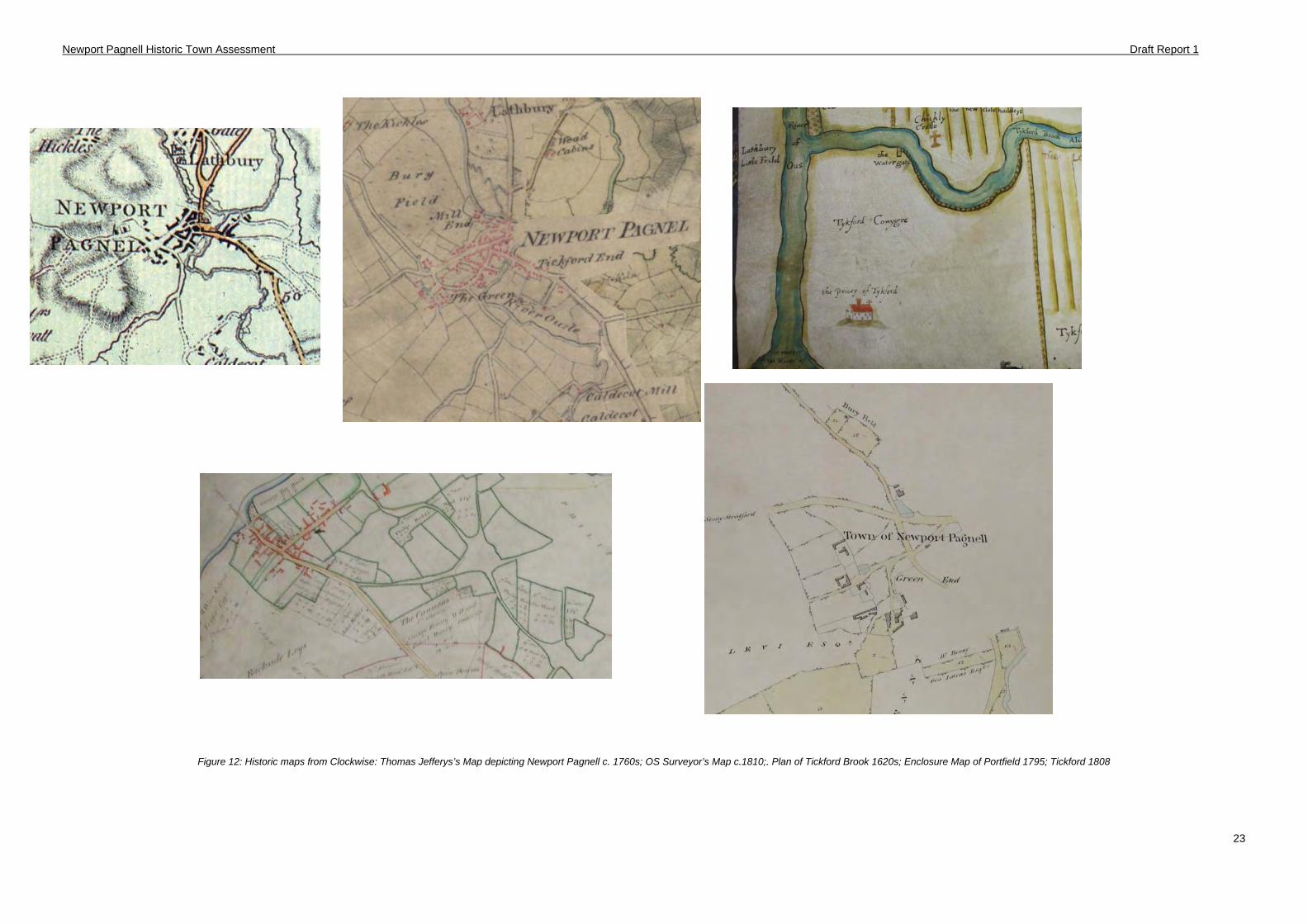
Figure 12: Historic maps from Clockwise: Thomas Jefferys’s Map depicting Newport Pagnell c. 1760s; OS Surveyor’s Map c.1810;. Plan of Tickford Brook 1620s; Enclosure Map of Portfield 1795; Tickford 1808
Newport Pagnell Historic Town Assessment Draft Report 1
24
Figure 13: Listed Buildings in Newport Pagnell
Newport Pagnell Historic Town Assessment Draft Report 1
25
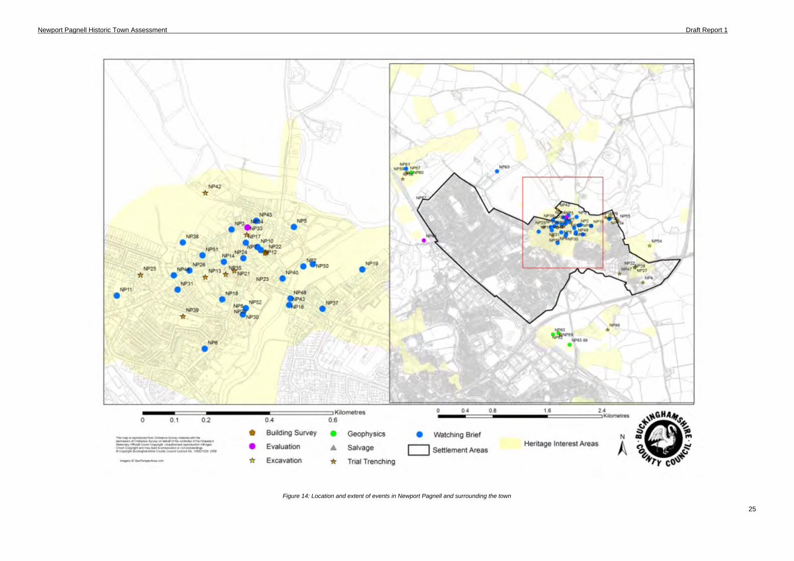
Figure 14: Location and extent of events in Newport Pagnell and surrounding the town
Newport Pagnell Historic Town Assessment Consultation Report
26
4.4 Archaeological Evidence
Newport Pagnell has a history of archaeological investigation dating back to the 1920s when excavations took place at the site of Tickford Abbey. However, it is not until modern archaeological intervention that the number of excavations increased especially since the late 1990s that there have been a consistent number of small-scale excavations and watching briefs within the historic core of the town. There are over 60 archaeological investigations in and around Newport Pagnell making it one of the more investigated towns in Buckinghamshire. The results of these events have been mixed, perhaps due to the extent that redevelopment has truncated deposits or to the scale of the archaeological intervention. Archaeological finds from the Saxon period or earlier have so far been rare, while material from the medieval period includes several pottery fabrics, coins and other artefacts.
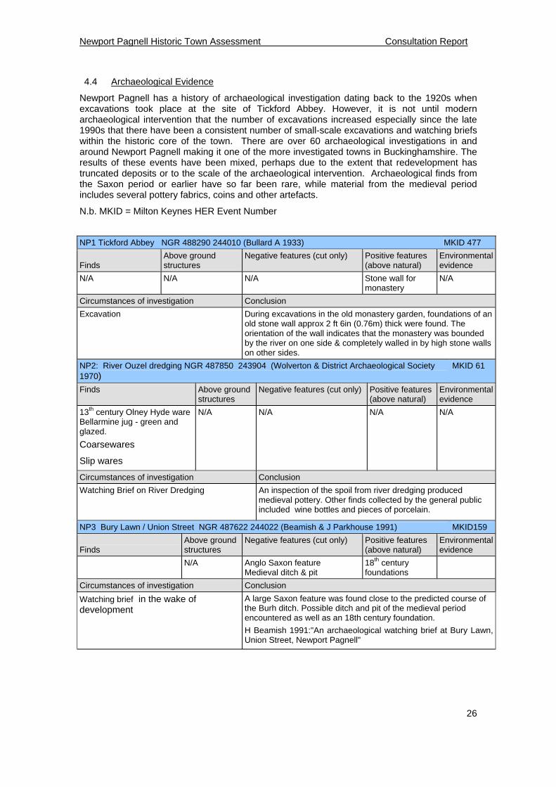
N.b. MKID = Milton Keynes HER Event Number
NP1 Tickford Abbey NGR 488290 244010 (Bullard A 1933) MKID 477
Finds
Above ground structures
Negative features (cut only) Positive features (above natural)
Environmental evidence
N/A N/A N/A Stone wall for monastery
N/A
Circumstances of investigation Conclusion
Excavation
During excavations in the old monastery garden, foundations of an old stone wall approx 2 ft 6in (0.76m) thick were found. The orientation of the wall indicates that the monastery was bounded by the river on one side & completely walled in by high stone walls on other sides.
NP2: River Ouzel dredging NGR 487850 243904 (Wolverton & District Archaeological Society 1970)
MKID 61
Finds Above ground structures
Negative features (cut only) Positive features (above natural)
Environmental evidence
13th century Olney Hyde ware Bellarmine jug - green and glazed.
Coarsewares
Slip wares
N/A N/A N/A N/A
Circumstances of investigation Conclusion
Watching Brief on River Dredging An inspection of the spoil from river dredging produced medieval pottery. Other finds collected by the general public included wine bottles and pieces of porcelain.
NP3 Bury Lawn / Union Street NGR 487622 244022 (Beamish & J Parkhouse 1991) MKID159
Finds
Above ground structures
Negative features (cut only) Positive features (above natural)
Environmental evidence
N/A Anglo Saxon feature Medieval ditch & pit
18th century foundations
Circumstances of investigation Conclusion
Watching brief in the wake of development
A large Saxon feature was found close to the predicted course of the Burh ditch. Possible ditch and pit of the medieval period encountered as well as an 18th century foundation.
H Beamish 1991:"An archaeological watching brief at Bury Lawn, Union Street, Newport Pagnell"
Newport Pagnell Historic Town Assessment Consultation Report
27
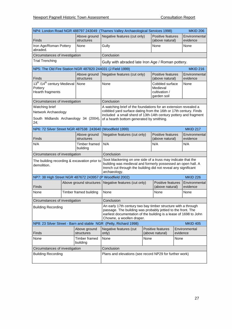
NP4: London Road NGR 488797 243049 (Thames Valley Archaeological Services 1998) MKID 206
Finds
Above ground structures
Negative features (cut only) Positive features (above natural)
Environmental evidence
Iron Age/Roman Pottery abraded.
None Gully None None
Circumstances of investigation Conclusion
Trial Trenching Gully with abraded late Iron Age / Roman pottery.
NP5: The Old Fire Station NGR 487820 244031 (J Field 1999) MKID 216
Finds
Above ground structures
Negative features (cut only) Positive features (above natural)
Environmental evidence
13th /14th century Medieval Pottery Hearth fragments
None None Cobbled surface Medieval cultivation / garden soil
None
Circumstances of investigation Conclusion
Watching brief
Network Archaeology
South Midlands Archaeology 34 (2004), 24;
A watching brief of the foundations for an extension revealed a cobbled yard surface dating from the 16th or 17th century. Finds included a small sherd of 13th-14th century pottery and fragment of a hearth bottom generated by smithing.
NP6: 72 Silver Street NGR 487538 243640 (Woodfield 1999) MKID 217
Finds
Above ground structures
Negative features (cut only) Positive features (above natural)
Environmental evidence
N/A Timber framed building
N/A N/A N/A
Circumstances of investigation Conclusion
The building recording & excavation prior to demolition.
Soot blackening on one side of a truss may indicate that the building was medieval and formerly possessed an open hall. A trench cut through the building did not reveal any significant archaeology.
NP7: 38 High Street NGR 487672 243957 (P Woodfield 2002) MKID 226
Finds
Above ground structures Negative features (cut only) Positive features (above natural)
Environmental evidence
None Timber framed building None None None
Circumstances of investigation Conclusion
Building Recording
An early 17th century two bay timber structure with a through passage. The building was probably jettied to the front. The earliest documentation of the building is a lease of 1698 to John Chowne, a woollen draper.
NP8: 23 Silver Street - Barn and stable NGR (Petty, Richard 1998) MKID 405
Finds
Above ground structures
Negative features (cut only)
Positive features (above natural)
Environmental evidence
None Timber framed building
None None None
Circumstances of investigation Conclusion
Building Recording Plans and elevations (see record NP29 for further work)
Newport Pagnell Historic Town Assessment Consultation Report
28
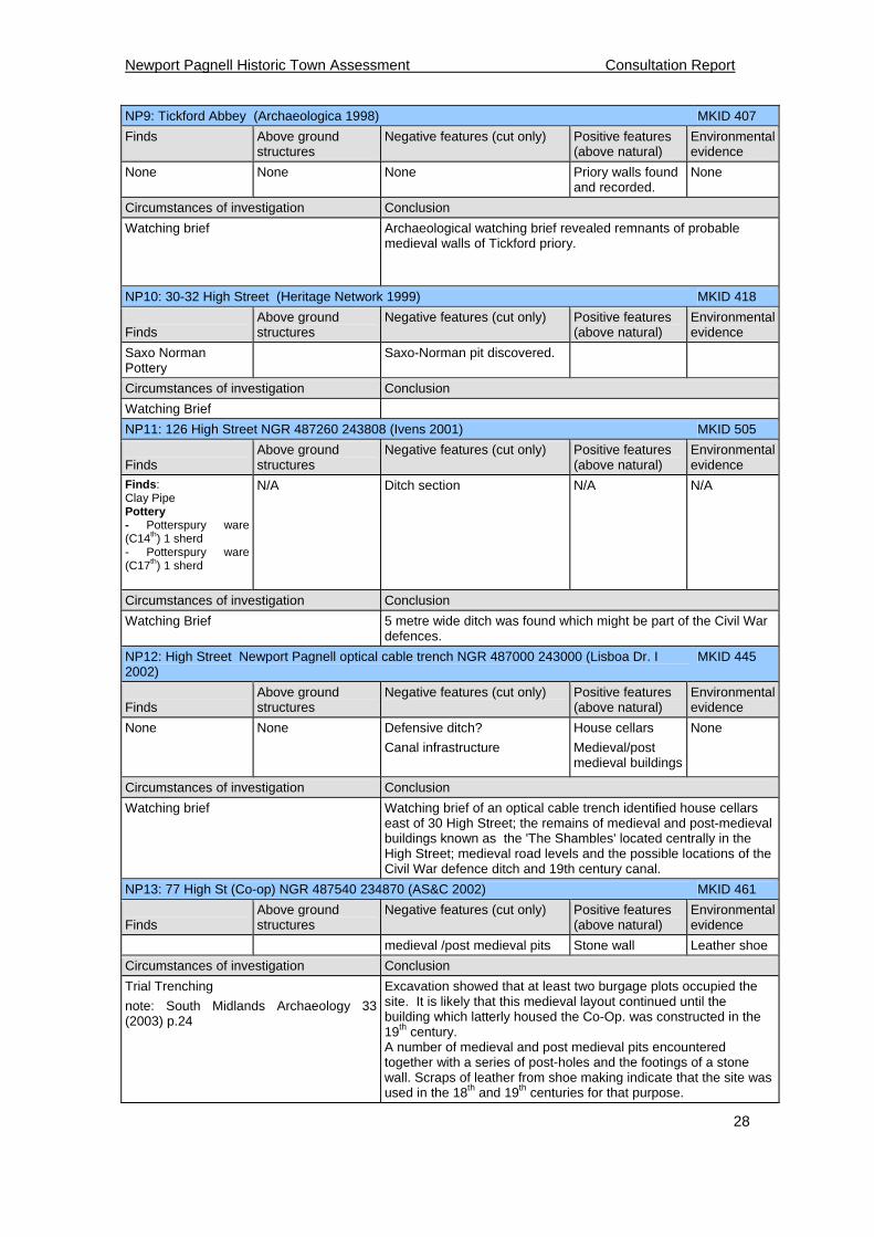
NP9: Tickford Abbey (Archaeologica 1998) MKID 407
Finds Above ground structures
Negative features (cut only) Positive features (above natural)
Environmental evidence
None None None Priory walls found and recorded.
None
Circumstances of investigation Conclusion
Watching brief
Archaeological watching brief revealed remnants of probable medieval walls of Tickford priory.
NP10: 30-32 High Street (Heritage Network 1999) MKID 418
Finds
Above ground structures
Negative features (cut only) Positive features (above natural)
Environmental evidence
Saxo Norman Pottery
Saxo-Norman pit discovered.
Circumstances of investigation Conclusion
Watching Brief
NP11: 126 High Street NGR 487260 243808 (Ivens 2001) MKID 505
Finds
Above ground structures
Negative features (cut only) Positive features (above natural)
Environmental evidence
Finds: Clay Pipe Pottery - Potterspury ware (C14th) 1 sherd - Potterspury ware (C17th) 1 sherd
N/A Ditch section N/A N/A
Circumstances of investigation Conclusion
Watching Brief 5 metre wide ditch was found which might be part of the Civil War defences.
NP12: High Street Newport Pagnell optical cable trench NGR 487000 243000 (Lisboa Dr. I 2002)
MKID 445
Finds
Above ground structures
Negative features (cut only) Positive features (above natural)
Environmental evidence
None None Defensive ditch?
Canal infrastructure
House cellars
Medieval/post medieval buildings
None
Circumstances of investigation Conclusion
Watching brief Watching brief of an optical cable trench identified house cellars east of 30 High Street; the remains of medieval and post-medieval buildings known as the 'The Shambles' located centrally in the High Street; medieval road levels and the possible locations of the Civil War defence ditch and 19th century canal.
NP13: 77 High St (Co-op) NGR 487540 234870 (AS&C 2002) MKID 461
Finds
Above ground structures
Negative features (cut only) Positive features (above natural)
Environmental evidence
medieval /post medieval pits Stone wall Leather shoe
Circumstances of investigation Conclusion
Trial Trenching
note: South Midlands Archaeology 33 (2003) p.24
Excavation showed that at least two burgage plots occupied the site. It is likely that this medieval layout continued until the building which latterly housed the Co-Op. was constructed in the 19th century. A number of medieval and post medieval pits encountered together with a series of post-holes and the footings of a stone wall. Scraps of leather from shoe making indicate that the site was used in the 18th and 19th centuries for that purpose.
Newport Pagnell Historic Town Assessment Consultation Report
29
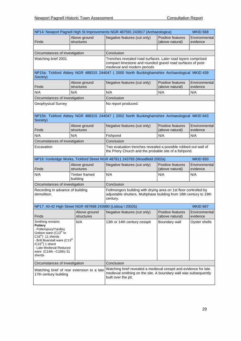
NP14: Newport Pagnell High St Improvements NGR 487591 243917 (Archaeologica) MKID 568
Finds
Above ground structures
Negative features (cut only) Positive features (above natural)
Environmental evidence
Circumstances of investigation Conclusion
Watching brief 2001
Trenches revealed road surfaces. Later road layers comprised compact limestone and rounded gravel road surfaces of post-medieval and modern periods
NP15a: Tickford Abbey NGR 488315 244047 ( 2000 North Buckinghamshire Archaeological Society)
MKID 439
Finds
Above ground structures
Negative features (cut only) Positive features (above natural)
Environmental evidence
N/A N/A N/A N/A N/A
Circumstances of investigation Conclusion
Geophysical Survey
No report produced.
NP15b: Tickford Abbey NGR 488315 244047 ( 2002 North Buckinghamshire Archaeological Society)
MKID 643
Finds
Above ground structures
Negative features (cut only) Positive features (above natural)
Environmental evidence
N/A N/A Fishpond N/A N/A
Circumstances of investigation Conclusion
Excavation
Two evaluation trenches revealed a possible robbed-out wall of the Priory Church and the probable site of a fishpond.
NP16: Ironbridge Works, Tickford Street NGR 487811 243765 (Woodfield 2002a) MKID 650
Finds
Above ground structures
Negative features (cut only) Positive features (above natural)
Environmental evidence
N/A Timber framed building
N/A N/A N/A
Circumstances of investigation Conclusion
Recording in advance of building demolition.
Fellmongers building with drying area on 1st floor controlled by adjustable shutters. Multiphase building from 18th century to 19th century.
NP17: 40-42 High Street NGR 487668 243980 (Lisboa I 2002b) MKID 667
Finds
Above ground structures
Negative features (cut only) Positive features (above natural)
Environmental evidence
Smithing remains Pottery - Potterspury/Yardley Gobion ware (C13th to C16th) 11 sherds - Brill Boarstall ware (C13th /C15th) 1 sherd - Late Medieval Reduced ware (C14th –C16th) 31 sherds
N/A 13th or 14th century cesspit Boundary wall Oyster shells
Circumstances of investigation Conclusion
Watching brief of rear extension to a late 17th century building
Watching brief revealed a medieval cesspit and evidence for late medieval smithing on the site. A boundary wall was subsequently built over the pit.
Newport Pagnell Historic Town Assessment Consultation Report
30
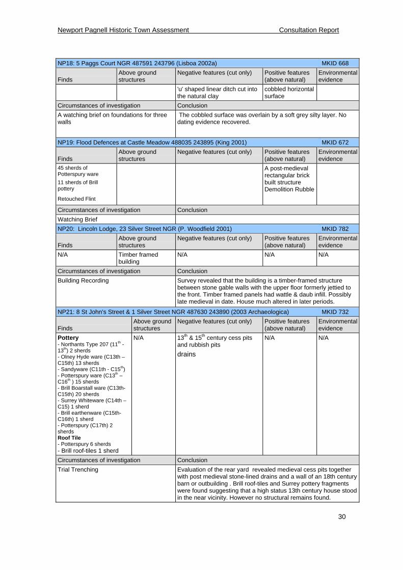
NP18: 5 Paggs Court NGR 487591 243796 (Lisboa 2002a) MKID 668
Finds
Above ground structures
Negative features (cut only) Positive features (above natural)
Environmental evidence
'u' shaped linear ditch cut into the natural clay
cobbled horizontal surface
Circumstances of investigation Conclusion
A watching brief on foundations for three walls
The cobbled surface was overlain by a soft grey silty layer. No dating evidence recovered.
NP19: Flood Defences at Castle Meadow 488035 243895 (King 2001) MKID 672
Finds
Above ground structures
Negative features (cut only) Positive features (above natural)
Environmental evidence
45 sherds of Potterspury ware
11 sherds of Brill pottery
Retouched Flint
A post-medieval rectangular brick built structure Demolition Rubble
Circumstances of investigation Conclusion
Watching Brief
NP20: Lincoln Lodge, 23 Silver Street NGR (P. Woodfield 2001) MKID 782
Finds
Above ground structures
Negative features (cut only) Positive features (above natural)
Environmental evidence
N/A Timber framed building
N/A N/A N/A
Circumstances of investigation Conclusion
Building Recording
Survey revealed that the building is a timber-framed structure between stone gable walls with the upper floor formerly jettied to the front. Timber framed panels had wattle & daub infill. Possibly late medieval in date. House much altered in later periods.
NP21: 8 St John's Street & 1 Silver Street NGR 487630 243890 (2003 Archaeologica) MKID 732
Finds
Above ground structures
Negative features (cut only) Positive features (above natural)
Environmental evidence
Pottery - Northants Type 207 (11th -13th) 2 sherds - Olney Hyde ware (C13th –C15th) 13 sherds - Sandyware (C11th - C15th) - Potterspury ware (C13th – C16th ) 15 sherds - Brill Boarstall ware (C13th-C15th) 20 sherds - Surrey Whiteware (C14th – C15) 1 sherd - Brill earthenware (C15th-C16th) 1 sherd - Potterspury (C17th) 2 sherds Roof Tile - Potterspury 6 sherds - Brill roof-tiles 1 sherd
N/A 13th & 15th century cess pits and rubbish pits
drains
N/A N/A
Circumstances of investigation Conclusion
Trial Trenching
Evaluation of the rear yard revealed medieval cess pits together with post medieval stone-lined drains and a wall of an 18th century barn or outbuilding . Brill roof-tiles and Surrey pottery fragments were found suggesting that a high status 13th century house stood in the near vicinity. However no structural remains found.
Newport Pagnell Historic Town Assessment Consultation Report
31
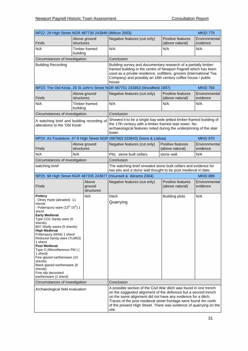
NP22: 29 High Street NGR 487730 243949 (Wilcox 2003) MKID 775
Finds
Above ground structures
Negative features (cut only) Positive features (above natural)
Environmental evidence
N/A Timber framed building
N/A N/A N/A
Circumstances of investigation Conclusion
Building Recording
Building survey and documentary research of a partially timber-framed building in the centre of Newport Pagnell which has been used as a private residence, outfitters, grocers (International Tea Company) and possibly an 18th century coffee house / public house.
NP23: The Old Kiosk, 26 St John's Street NGR 487701 243853 (Woodfield 1997) MKID 794
Finds
Above ground structures
Negative features (cut only) Positive features (above natural)
Environmental evidence
N/A Timber framed building
N/A N/A N/A
Circumstances of investigation Conclusion
A watching brief and building recording of alterations to the 'Old Kiosk'
Showed it to be a single bay wide jettied timber-framed building of the 17th century with a timber-framed stair tower. No archaeological features noted during the underpinning of the stair tower.
NP24: A1 Foodstore, 47-9 High Street NGR (487663 233943) (Ivens & Lisboa) MKID 870
Finds
Above ground structures
Negative features (cut only) Positive features (above natural)
Environmental evidence
N/A N/A Pits, stone built cellars stone wall. N/A
Circumstances of investigation Conclusion
watching brief The watching brief revealed stone built cellars and evidence for two pits and a stone wall thought to be post medieval in date.
NP25: 98 High Street NGR 487335 243877 (Hounsell & Abrams 2004) MKID 889
Finds
Above ground structures
Negative features (cut only) Positive features (above natural)
Environmental evidence
Pottery - Olney Hyde (abraded) 11 sherds - Potterspury ware (13th 15th) 1 sherd Early Medieval Type CO1 Sandy ware (6 sherds) B07 Shelly wares (5 sherds) High Medieval Potterspury (MS6) 1 sherd Reduced Sandy ware (TLM53) 1 sherd Post Medieval Type O (Miscellaneous PM ) ( 1 sherd) Fine glazed earthenware (10 sherds) Black glazed earthenware (8 sherds) Fine slip decorated earthenware (1 sherd)
N/A Ditch
Quarrying
Building plots N/A
Circumstances of investigation Conclusion
Archaeological field evaluation A possible section of the Civil War ditch was found in one trench on the suggested alignment of the defences but a second trench on the same alignment did not have any evidence for a ditch. Traces of the post medieval street frontage were found 4m north of the present High Street. There was evidence of quarrying on the site.
Newport Pagnell Historic Town Assessment Consultation Report
32
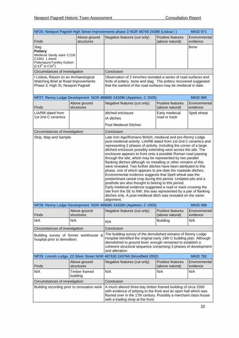
NP26: Newport Pagnell High Street Improvements phase 3 NGR 48749 24389 (Lisboa I ) MKID 971
Finds
Above ground structures
Negative features (cut only) Positive features (above natural)
Environmental evidence
Slag Pottery Medieval Sandy ware C11th C15th) 1 sherd Potterspury/Yardley Gobion (C13th to C16th)
Bone
Circumstances of investigation Conclusion
I Lisboa, Report on an Archaeological Watching Brief at Road Improvements Phase 3, High St, Newport Pagnell
Observation of 2 trenches revealed a series of road surfaces and finds of pottery, bone and slag. The pottery recovered suggested that the earliest of the road surfaces may be medieval in date.
NP27: Renny Lodge Development NGR 488680 243280 (Appleton, C 2005) MKID 995
Finds
Above ground structures
Negative features (cut only) Positive features (above natural)
Environmental evidence
LIA/RB dated from 1st-2nd C ceramics
ditched enclosure
IA ditches
Post Medieval Ditches
Early medieval road or track
Spelt wheat
Circumstances of investigation Conclusion
Strip, Map and Sample
Late Iron Age/Romano British, medieval and pre-Renny Lodge post-medieval activity. LIA/RB dated from 1st-2nd C ceramics and representing 2 phases of activity, including the corner of a large ditched enclosure possibly extending west across the site. The enclosure appears to front onto a possible Roman road passing through the site, which may be represented by two parallel flanking ditches although no metalling or other remains of this were revealed. Two further ditches have been attributed to this phase, one of which appears to pre-date the roadside ditches. Environmental evidence suggests that Spelt wheat was the predominant cereal crop during this period. Undated pits and a posthole are also thought to belong to this period. Early medieval evidence suggested a road or track crossing the site from the SE to NW, this was represented by a pair of flanking ditches only. A post-medieval ditch was revealed on the same alignment.
NP28: Renny Lodge Development NGR 488680 243280 (Appleton, C 2005) MKID 996
Finds
Above ground structures
Negative features (cut only) Positive features (above natural)
Environmental evidence
N/A N/A N/A Building N/A
Circumstances of investigation Conclusion
Building survey of former workhouse & hospital prior to demolition.
The building survey of the demolished remains of Renny Lodge Hospital identified the original early 19th C building plan. Although demolished to ground level, enough remained to establish a coherent structural sequence comprising 3 phases of development and alteration.
NP29: Lincoln Lodge, 23 Silver Street NGR 487630 243766 (Woodfield 2002) MKID 782
Finds
Above ground structures
Negative features (cut only) Positive features (above natural)
Environmental evidence
N/A Timber framed building
N/A N/A N/A
Circumstances of investigation Conclusion
Building recording prior to renovation work
A much altered three-bay timber-framed building of circa 1500 with evidence of jettying to the front and an open hall which was floored over in the 17th century. Possibly a merchant class house with a trading shop at the front.
Newport Pagnell Historic Town Assessment Consultation Report
33
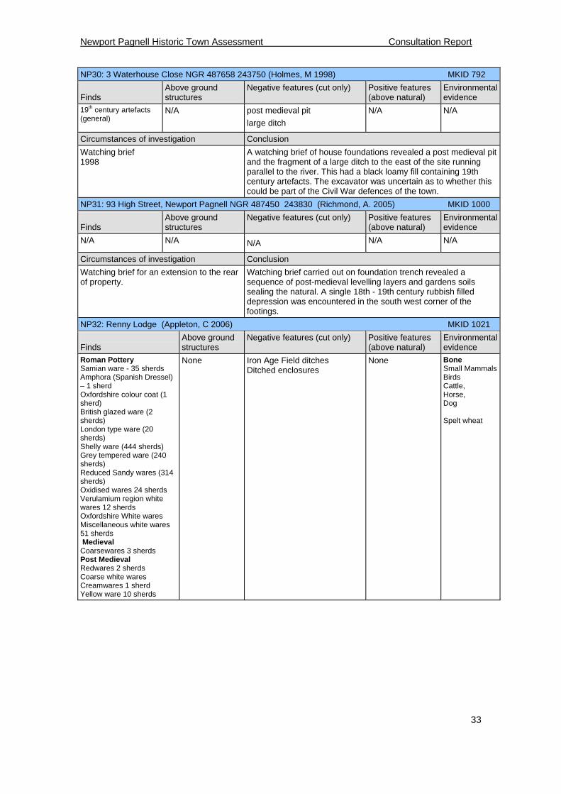
NP30: 3 Waterhouse Close NGR 487658 243750 (Holmes, M 1998) MKID 792
Finds
Above ground structures
Negative features (cut only) Positive features (above natural)
Environmental evidence
19th century artefacts (general)
N/A post medieval pit
large ditch
N/A N/A
Circumstances of investigation Conclusion
Watching brief 1998
A watching brief of house foundations revealed a post medieval pit and the fragment of a large ditch to the east of the site running parallel to the river. This had a black loamy fill containing 19th century artefacts. The excavator was uncertain as to whether this could be part of the Civil War defences of the town.
NP31: 93 High Street, Newport Pagnell NGR 487450 243830 (Richmond, A. 2005) MKID 1000
Finds
Above ground structures
Negative features (cut only) Positive features (above natural)
Environmental evidence
N/A N/A N/A N/A N/A
Circumstances of investigation Conclusion
Watching brief for an extension to the rear of property.
Watching brief carried out on foundation trench revealed a sequence of post-medieval levelling layers and gardens soils sealing the natural. A single 18th - 19th century rubbish filled depression was encountered in the south west corner of the footings.
NP32: Renny Lodge (Appleton, C 2006) MKID 1021
Finds
Above ground structures
Negative features (cut only) Positive features (above natural)
Environmental evidence
Roman Pottery Samian ware - 35 sherds Amphora (Spanish Dressel) – 1 sherd Oxfordshire colour coat (1 sherd) British glazed ware (2 sherds) London type ware (20 sherds) Shelly ware (444 sherds) Grey tempered ware (240 sherds) Reduced Sandy wares (314 sherds) Oxidised wares 24 sherds Verulamium region white wares 12 sherds Oxfordshire White wares Miscellaneous white wares 51 sherds Medieval Coarsewares 3 sherds Post Medieval Redwares 2 sherds Coarse white wares Creamwares 1 sherd Yellow ware 10 sherds
None Iron Age Field ditches Ditched enclosures
None Bone Small MammalsBirds Cattle, Horse, Dog Spelt wheat

Newport Pagnell Historic Town Assessment Consultation Report
34
Circumstances of investigation Conclusion
Combined Trial Trenching & excavation
'Renny Lodge, Newport Pagnell, Milton Keynes - Fieldwork Assessment Report'
Post-excavation assessment of fieldwork at former Renny Lodge Hospital site. The excavation revealed at least 3 phases of late Iron Age/Romano-British activity on the site. The 1st phase (1st-mid 2nd C AD) comprised a field system and/or sub-square enclosure, with limited structural evidence including a shallow curvilinear ditch and a cobbled area. The 2nd phase was characterised by up to 3 ditched enclosures incorporated into the established field system. This was also the earliest phase for the roadside ditches defining the line of a Roman road and suggesting that the site comprised a small 2nd C roadside settlement. The final phase of Romano-British activity comprised recutting of some of the principal ditches and alterations to layout of features from phase 2. The medieval activity on the site chiefly comprised field ditches including a double ditched arrangement. The principal ditches of this phase may define a track or road perpendicular to the earlier Roman road.
NP33: 4-6 Union Street NGR 487671 244006 (Lodoen, A & Ingham, D 2008) MKID 1151
Finds
Above ground structures
Negative features (cut only) Positive features (above natural)
Environmental evidence
Anglo Saxon Pottery St Neots Type ware (2 sherds) Medieval Pottery Potterspury ware (1 sherd) Coarse Sandy wares Late Medieval reduced wares (1 sherd) Late Medieval Pottery Late Brill/Boarstall ware (5 sherds) Post Medieval Fine glazed Red Earthenware (1 sherd) Black Glazed Earthenware (2 sherds) Blackware (3 sherds) Brown salt glazed stoneware (2 sherds) Modern Creamware (14 sherds) Mocha ware (2 sherds) Peach ware (5 sherds) Transfer Print (2 sherds) White earthenware (2 sherds) Clay pipe
N/A 2 large late medieval / early post-medieval pits,
structural remains dating from the early post-medieval period into the Victorian era.
Animal Bone
Cattle (modern)
Circumstances of investigation Conclusion
Archaeological Evaluation
The structural remains are likely to relate to outbuildings to the rear of house plots along the High Street.
Newport Pagnell Historic Town Assessment Consultation Report
35
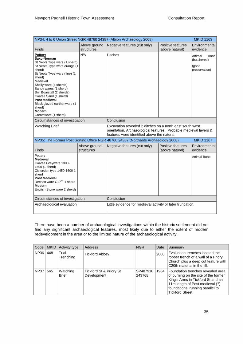
NP34: 4 to 6 Union Street NGR 48760 24387 (Albion Archaeology 2008) MKID 1163
Finds
Above ground structures
Negative features (cut only) Positive features (above natural)
Environmental evidence
Pottery Saxo-Norman St Neots Type ware (1 sherd) St Neots Type ware orange (1 sherd) St Neots Type ware (fine) (1 sherd) Medieval Shelly ware (4 sherds) Sandy wares (1 sherd) Brill Boarstall (2 sherds) Coarse Sand (1 sherd) Post Medieval Black glazed earthenware (1 sherd) Modern Creamware (1 sherd)
N/A Ditches Animal Bone (butchered)
(good preservation)
Circumstances of investigation Conclusion
Watching Brief
Excavation revealed 2 ditches on a north east south west orientation. Archaeological features. Probable medieval layers & features were identified above the natural.
NP35: The Former Post Sorting Office NGR 48760 24387 (Northants Archaeology 2008) MKID 1167
Finds
Above ground structures
Negative features (cut only) Positive features (above natural)
Environmental evidence
Pottery Medieval Coarse Greyware 1300-1500 (1 sherd) Cistercian type 1450-1600 1 sherd Post Medieval Rechen ware C17th 1 sherd Modern English Stone ware 2 sherds
Animal Bone
Circumstances of investigation Conclusion
Archaeological evaluation
Little evidence for medieval activity or later truncation.
There have been a number of archaeological investigations within the historic settlement did not find any significant archaeological features, most likely due to either the extent of modern redevelopment in the area or to the limited nature of the archaeological activity.
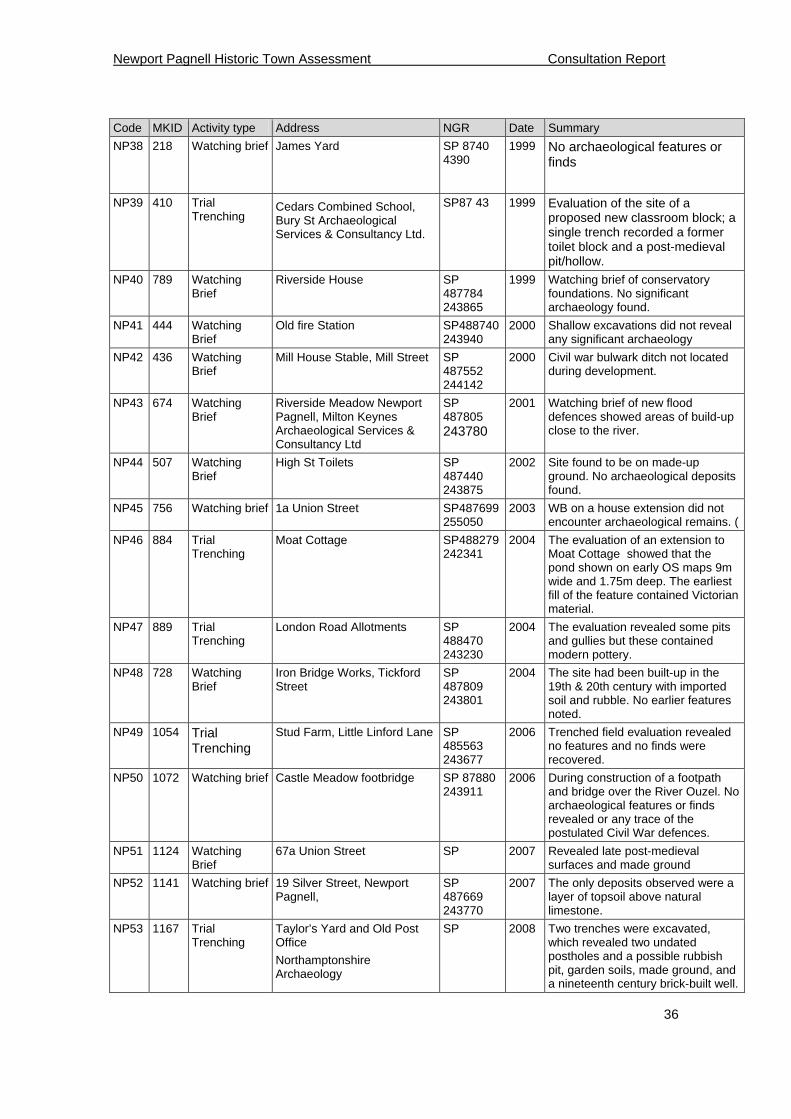
Code MKID Activity type Address NGR Date Summary
NP36 448 Trial Trenching
Tickford Abbey
2000
Evaluation trenches located the robber trench of a wall of a Priory Church plus a deep cut feature with C20th material in the fill.
NP37 565 Watching Brief
Tickford St & Priory St Development
SP487910 243768
1984 Foundation trenches revealed area of burning on the site of the former King's Arms in Tickford St and an 11m length of Post medieval (?) foundations running parallel to Tickford Street.
Newport Pagnell Historic Town Assessment Consultation Report
36
Code MKID Activity type Address NGR Date Summary
NP38 218 Watching brief
James Yard SP 8740 4390
1999 No archaeological features or finds
NP39 410 Trial Trenching
Cedars Combined School, Bury St Archaeological Services & Consultancy Ltd.
SP87 43 1999 Evaluation of the site of a proposed new classroom block; a single trench recorded a former toilet block and a post-medieval pit/hollow.
NP40 789 Watching Brief
Riverside House SP 487784 243865
1999 Watching brief of conservatory foundations. No significant archaeology found.
NP41 444 Watching Brief
Old fire Station SP488740243940
2000 Shallow excavations did not reveal any significant archaeology
NP42 436 Watching Brief
Mill House Stable, Mill Street SP 487552 244142
2000 Civil war bulwark ditch not located during development.
NP43 674 Watching Brief
Riverside Meadow Newport Pagnell, Milton Keynes Archaeological Services & Consultancy Ltd
SP 487805 243780
2001 Watching brief of new flood defences showed areas of build-up close to the river.
NP44 507 Watching Brief
High St Toilets SP 487440 243875
2002 Site found to be on made-up ground. No archaeological deposits found.
NP45 756 Watching brief 1a Union Street SP487699255050
2003 WB on a house extension did not encounter archaeological remains. (
NP46 884 Trial Trenching
Moat Cottage SP488279242341
2004 The evaluation of an extension to Moat Cottage showed that the pond shown on early OS maps 9m wide and 1.75m deep. The earliest fill of the feature contained Victorian material.
NP47 889 Trial Trenching
London Road Allotments SP 488470 243230
2004 The evaluation revealed some pits and gullies but these contained modern pottery.
NP48 728 Watching Brief
Iron Bridge Works, Tickford Street
SP 487809 243801
2004 The site had been built-up in the 19th & 20th century with imported soil and rubble. No earlier features noted.
NP49 1054 Trial Trenching
Stud Farm, Little Linford Lane SP 485563 243677
2006 Trenched field evaluation revealed no features and no finds were recovered.
NP50 1072 Watching brief Castle Meadow footbridge SP 87880 243911
2006 During construction of a footpath and bridge over the River Ouzel. No archaeological features or finds revealed or any trace of the postulated Civil War defences.
NP51 1124 Watching Brief
67a Union Street SP 2007 Revealed late post-medieval surfaces and made ground
NP52 1141 Watching brief 19 Silver Street, Newport Pagnell,
SP 487669 243770
2007 The only deposits observed were a layer of topsoil above natural limestone.
NP53 1167 Trial Trenching
Taylor’s Yard and Old Post Office
Northamptonshire Archaeology
SP 2008 Two trenches were excavated, which revealed two undated postholes and a possible rubbish pit, garden soils, made ground, and a nineteenth century brick-built well.
Newport Pagnell Historic Town Assessment Consultation Report
37
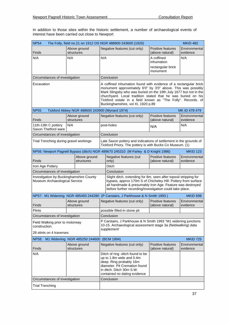
In addition to those sites within the historic settlement, a number of archaeological events of interest have been carried out close to Newport NP54 The Folly, field no.21 on 1912 OS NGR 488900 243600 (1920) MKID 482
Finds
Above ground structures
Negative features (cut only) Positive features (above natural)
Environmental evidence
N/A N/A N/A A coffined inhumation
rectangular brick monument
N/A
Circumstances of investigation Conclusion
Excavation A coffined inhumation found with evidence of a rectangular brick monument approximately 6'0" by 3'0" above. This was possibly Mark Slingsby who was buried on the 19th July 1677 but not in the churchyard. Local tradition stated that he was buried on his Tickford estate in a field known as "The Folly". Records. of Buckinghamshire, vol XI, 1920 p.89
NP55 Tickford Abbey NGR 488600 243900 (Mynard 1974) MK ID 478 479
Finds
Above ground structures
Negative features (cut only) Positive features (above natural)
Environmental evidence
11th-13th C pottery Saxon Thetford ware
N/A post-holes N/A N/A
Circumstances of investigation Conclusion
Trial Trenching during gravel workings Late Saxon pottery and indications of settlement in the grounds of Tickford Priory. The pottery is with Bucks Co Museum. (1)
NP56: Newport Pagnell Bypass (ditch) NGR 489670 245310 (M Farley & D Knight 1986) MKID 123
Finds
Above ground structures
Negative features (cut only)
Positive features (above natural)
Environmental evidence
Iron Age Pottery Ditch
Circumstances of investigation Conclusion
Investigation by Buckinghamshire County Museum Archaeological Service
Slight ditch, extending for 8m, seen after topsoil stripping for bypass, approx 170m S of Chicheley Hill. Pottery from surface all handmade & presumably Iron Age. Feature was destroyed before further recording/investigation could take place.
NP57: M1 Widening NGR 485450 244280 (P Carstairs, J Parkhouse & N Smith 1993 ) MKID 698
Finds
Above ground structures
Negative features (cut only) Positive features (above natural)
Environmental evidence
Flints possible filled-in stone pit
Circumstances of investigation Conclusion
Field Walking prior to motorway construction.
28 stints on 4 traverses
P Carstairs, J Parkhouse & N Smith 1993 "M1 widening junctions 10-15. Archaeological assessment stage 3a (fieldwalking) data supplement'
NP58: M1 Widening NGR 485250 244600 (BCM 1994) MKID 725
Finds
Above ground structures
Negative features (cut only) Positive features (above natural)
Environmental evidence
N/A Ditch of ring -ditch found to be up to 1.8m wide and 0.4m deep. Ring probably 16m diameter. Pit Cremation found in ditch. Ditch 30m S.W. contained no dating evidence
Circumstances of investigation Conclusion
Trial Trenching

Newport Pagnell Historic Town Assessment Consultation Report
38
NP59: Gayhurst Quarry NGR 485300 244700 (Northamptonshire Archaeology 1997) MKID 213
Finds
Above ground structures
Negative features (cut only) Positive features (above natural)
Environmental evidence
late Neolithic / Bronze Age round barrow
Iron Age Ditch enclosures 4 late Neolithic / Bronze Age round barrows
Animal bones
Circumstances of investigation Conclusion
Trial Trenching
NA 1997 "Archaeological Evaluation at Gayhurst Quarry, Buckinghamshire. Stage 2: Trial excavation"
The evaluation confirmed the presence of 4 round barrows of late Neolithic / Bronze Age date but none survived as upstanding mounds. One barrow did survive as a slight earthwork and had a large quantity of animal bones in the ditch fill. This barrow was subjected to stream erosion. Two adjacent ditched enclosures and a palisade enclosure were found to be of Iron Age date.
NP60: Gayhurst Quarry NGR 485380 244696 (Northamptonshire Archaeology 1997) MKID 788
Finds
Above ground structures
Negative features (cut only) Positive features (above natural)
Environmental evidence
N/A N/A N/A N/A N/A
Circumstances of investigation Conclusion
Geophysical survey
A magnetometer survey revealed 5 ring ditches, 3 enclosures and linear anomalies and possible palaeochannels. Parallel linear anomalies covering the whole site denoted the former presence of a medieval ridge and furrow field system.
NP61: Gayhurst Quarry NGR 485300 244750 (Northamptonshire Archaeology 2000) MKID 442
Finds
Above ground structures
Negative features (cut only) Positive features (above natural)
Environmental evidence
Cremation burials Pits
Circumstances of investigation Conclusion
Watching Brief
Letter from Northampton Archaeology to the Archaeological Officer dated 28 July 2000
Pit alignment discovered producing a radio-carbon date of 800-520cal BC placing it in the early Iron Age. Two further urned cremations deposits discovered.
NP62: Land west of Caldecotte Farm (Dr I Lisboa 2001) MKID 673
Finds
Above ground structures
Negative features (cut only) Positive features (above natural)
Environmental evidence
None None None
Circumstances of investigation Conclusion
Geophysical survey: A magnetometer and susceptibility survey.
Magnetometer survey revealed several clusters of magnetic anomalies which indicated a possible eastward extension of the known prehistoric settlement.
NP63: Flood Defence (King 2001) MKID 671
Finds
Above ground structures
Negative features (cut only) Positive features (above natural)
Environmental evidence
Flint scraper
Microlith?
Ridge and furrow
Circumstances of investigation Conclusion
Watching brief Topsoil stripping revealed ridge and furrow, a flint scraper and a possible microlith
NP64: Blank record MKID N/A
Finds
Above ground structures
Negative features (cut only) Positive features (above natural)
Environmental evidence
None None None None
Circumstances of investigation Conclusion
Newport Pagnell Historic Town Assessment Consultation Report
39
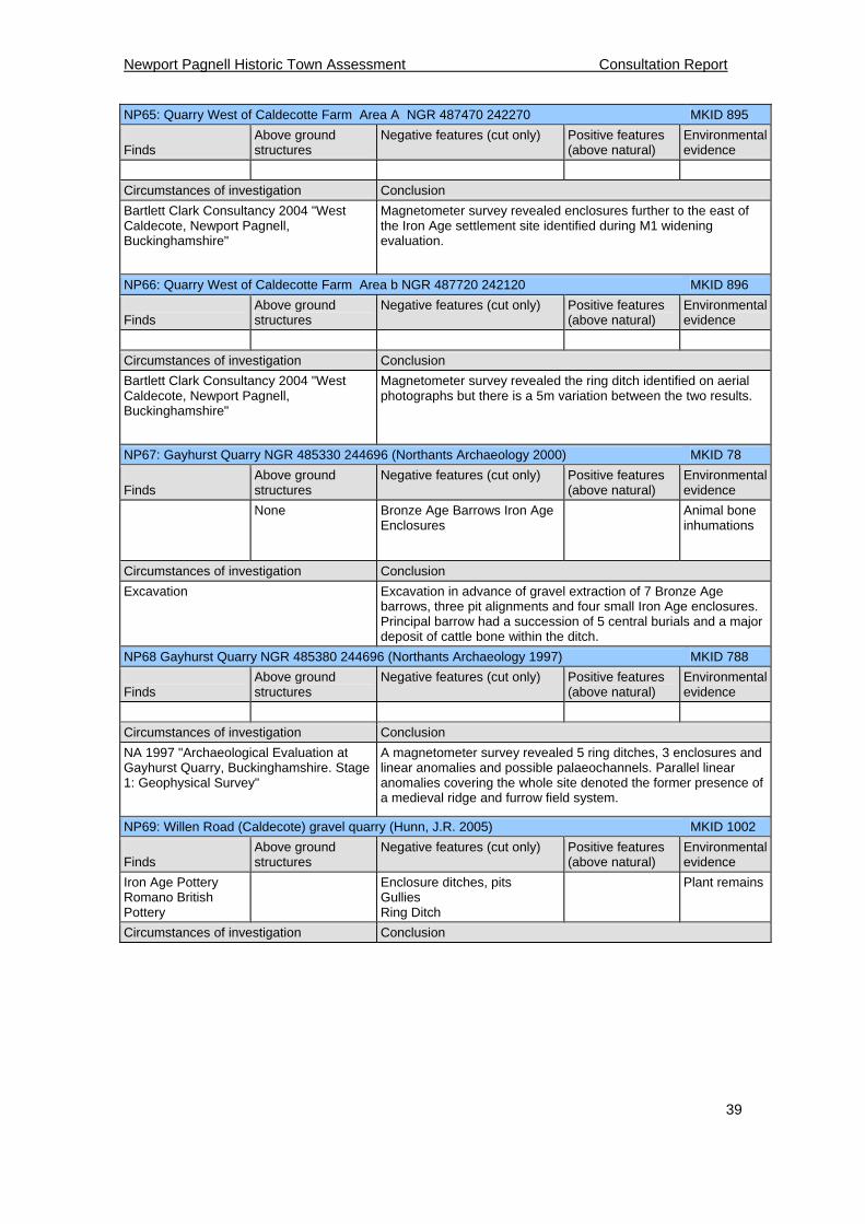
NP65: Quarry West of Caldecotte Farm Area A NGR 487470 242270 MKID 895
Finds
Above ground structures
Negative features (cut only) Positive features (above natural)
Environmental evidence
Circumstances of investigation Conclusion
Bartlett Clark Consultancy 2004 "West Caldecote, Newport Pagnell, Buckinghamshire"
Magnetometer survey revealed enclosures further to the east of the Iron Age settlement site identified during M1 widening evaluation.
NP66: Quarry West of Caldecotte Farm Area b NGR 487720 242120 MKID 896
Finds
Above ground structures
Negative features (cut only) Positive features (above natural)
Environmental evidence
Circumstances of investigation Conclusion
Bartlett Clark Consultancy 2004 "West Caldecote, Newport Pagnell, Buckinghamshire"
Magnetometer survey revealed the ring ditch identified on aerial photographs but there is a 5m variation between the two results.
NP67: Gayhurst Quarry NGR 485330 244696 (Northants Archaeology 2000) MKID 78
Finds
Above ground structures
Negative features (cut only) Positive features (above natural)
Environmental evidence
None Bronze Age Barrows Iron Age Enclosures
Animal bone inhumations
Circumstances of investigation Conclusion
Excavation
Excavation in advance of gravel extraction of 7 Bronze Age barrows, three pit alignments and four small Iron Age enclosures. Principal barrow had a succession of 5 central burials and a major deposit of cattle bone within the ditch.
NP68 Gayhurst Quarry NGR 485380 244696 (Northants Archaeology 1997) MKID 788
Finds
Above ground structures
Negative features (cut only) Positive features (above natural)
Environmental evidence
Circumstances of investigation Conclusion
NA 1997 "Archaeological Evaluation at Gayhurst Quarry, Buckinghamshire. Stage 1: Geophysical Survey"
A magnetometer survey revealed 5 ring ditches, 3 enclosures and linear anomalies and possible palaeochannels. Parallel linear anomalies covering the whole site denoted the former presence of a medieval ridge and furrow field system.
NP69: Willen Road (Caldecote) gravel quarry (Hunn, J.R. 2005) MKID 1002
Finds
Above ground structures
Negative features (cut only) Positive features (above natural)
Environmental evidence
Iron Age Pottery Romano British Pottery
Enclosure ditches, pits Gullies Ring Ditch
Plant remains
Circumstances of investigation Conclusion
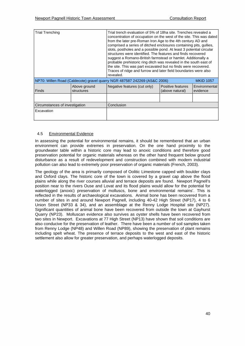
Newport Pagnell Historic Town Assessment Consultation Report
40
Trial Trenching
Trial trench evaluation of 5% of 18ha site. Trenches revealed a concentration of occupation on the west of the site. This was dated from the later pre-Roman Iron Age to the 4th century AD and comprised a series of ditched enclosures containing pits, gullies, slots, postholes and a possible pond. At least 3 potential circular structures were identified. The features and finds recovered suggest a Romano-British farmstead or hamlet. Additionally a probable prehistoric ring ditch was revealed in the south east of the site. This was part excavated but no finds were recovered. Traces of ridge and furrow and later field boundaries were also revealed.
NP70: Willen Road (Caldecote) gravel quarry NGR 487587 242269 (AS&C 2006) MKID 1057
Finds
Above ground structures
Negative features (cut only) Positive features (above natural)
Environmental evidence
Circumstances of investigation Conclusion
Excavation
4.5 Environmental Evidence
In assessing the potential for environmental remains, it should be remembered that an urban environment can provide extremes in preservation. On the one hand proximity to the groundwater table within a historic core may lead to anoxic conditions and therefore good preservation potential for organic materials whereas on the other hand frequent below ground disturbance as a result of redevelopment and construction combined with modern industrial pollution can also lead to extremely poor preservation of organic materials (French, 2003).
The geology of the area is primarily composed of Oolitic Limestone capped with boulder clays and Oxford clays. The historic core of the town is covered by a gravel cap above the flood plains while along the river courses alluvial and terrace deposits are found. Newport Pagnell’s position near to the rivers Ouse and Lovat and its flood plains would allow for the potential for waterlogged (anoxic) preservation of molluscs, bone and environmental remains’. This is reflected in the results of archaeological excavations. Animal bone has been recovered from a number of sites in and around Newport Pagnell, including 40-42 High Street (NP17), 4 to 6 Union Street (NP33 & 34), and an assemblage at the Renny Lodge Hospital site (NP27). Significant quantities of animal bone have been recovered from outside the town at Gayhurst Quarry (NP23). Molluscan evidence also survives as oyster shells have been recovered from two sites in Newport. Excavations at 77 High Street (NP13) have shown that soil conditions are also conducive for the preservation of leather. There have been a number of soil samples taken from Renny Lodge (NP48) and Willen Road (NP89), showing the preservation of plant remains including spelt wheat. The presence of terrace deposits to the west and east of the historic settlement also allow for greater preservation, and perhaps waterlogged deposits.
Newport Pagnell Historic Town Assessment Draft Report 1
41
5 Archaeological & Historical Development
5.1 Prehistoric period (c.10,000 BC – AD 43)
The archaeological record shows some evidence for prehistoric activity in and around Newport Pagnell. The confluence of the Ouse and Lovat seems to have been a magnet for human activity. The earliest evidence dates to the Mesolithic period, when a flint blade core was discovered during the excavation of footings on Tickford Street. (ID No. 4269) Newport has also produced some chance finds dating to the Neolithic period which have been found in and around the town; these include a number of stone axe fragments, one of which was uncovered at Bury Field between Kickles Farm and the river Ouse (CASS No. 52700000) another at 84 Silver Street (CASS No. 533200000) and a portion of a Neolithic stone axe found on Tickford Street (ID No. 3825). Interestingly petrological analysis of the axes from Bury field and Tickford showed that they originated respectively from Langdale in Cumbria and Cornwall. These areas are known Neolithic ‘axe factories’ where the geological outcrops of hard igneous and metamorphic rocks are suitable for the production of axe heads for tree felling and carpentry. These stone axes were of value and were traded widely across Britain, indicating that they might have been carried in bulk to distant redistribution centres including one around Cambridge (Dyer 1990).
Although early prehistoric evidence is limited to chance finds of flint arrow heads, blades and worked flints, there is more evidence for settlement and ceremony for the late Neolithic and Bronze Age periods. Aerial photography at King’s Holme Meadow two miles to the north of Newport Pagnell identified Late Neolithic/Bronze Age ring ditches (CASS No.135300000) and also two more ring ditches just north of Kickles Farm along the Ouse (CASS No. 424300000). These ring ditches are interpreted as prehistoric round barrows, an assertion supported by historical evidence where there are references to the presence of a burial tumulus on Bury field, although this has since been destroyed by levelling and ploughing the field as part of the war effort (Page 1927 VCH Vol 4). However the most tangible evidence comes from excavations in advance of quarrying; at Gayhurst Quarry to the north of Newport revealed a landscape rich in Late Neolithic and Early Bronze Age occupation (NP59). This included six ring ditches and enclosures. Also the survey of the Hartigans site revealed evidence of cremation burial inside one ring ditch. Within the town there has been sporadic discovery of finds; local historian Alfred Bullard recorded the discovery of burial urn sherds on the high ground above St John’s Street (Bullard 1933).
There is some evidence for Iron Age occupation in and around Newport Pagnell. During the Late Iron Age and into the Roman period, Buckinghamshire fell under the territory of a south-eastern tribe called the Catuvellauni who had major settlement bases to the east at Colchester and St Albans. Newport lay on the northwest border of their territory. Some evidence for Late Iron Age occupation is evident in the excavations at Tickford Abbey (NP9). However, the principal evidence for Iron Age settlement comes from the archaeological investigation at Renny Lodge Hospital on the London road (NP27). This excavation revealed enclosure and ditches aligned next to a road which is thought to be a late Iron Age/Roman road running southeast - northwest across the site. The outskirts of Newport have produced more evidence for Iron Age occupation; excavations on the link road at Chicheley Hill revealed Iron Age pottery and features (Farley & Knight 1986).
There is some intriguing place name evidence in the name Bury Field (north of the town) to suggest that Newport might have been an early defended settlement. The topography and position of Newport’s old town is generally low lying but it is sufficiently elevated on a cap of Oxford clay and gravels and bounded on two sides by the rivers Ouse and Lovat. There are other examples of lowland hillforts in Buckinghamshire such as Norbury [SAM 29407], also positioned along the river Ouse. However so far there is no archaeological evidence to substantiate this hypothesis.
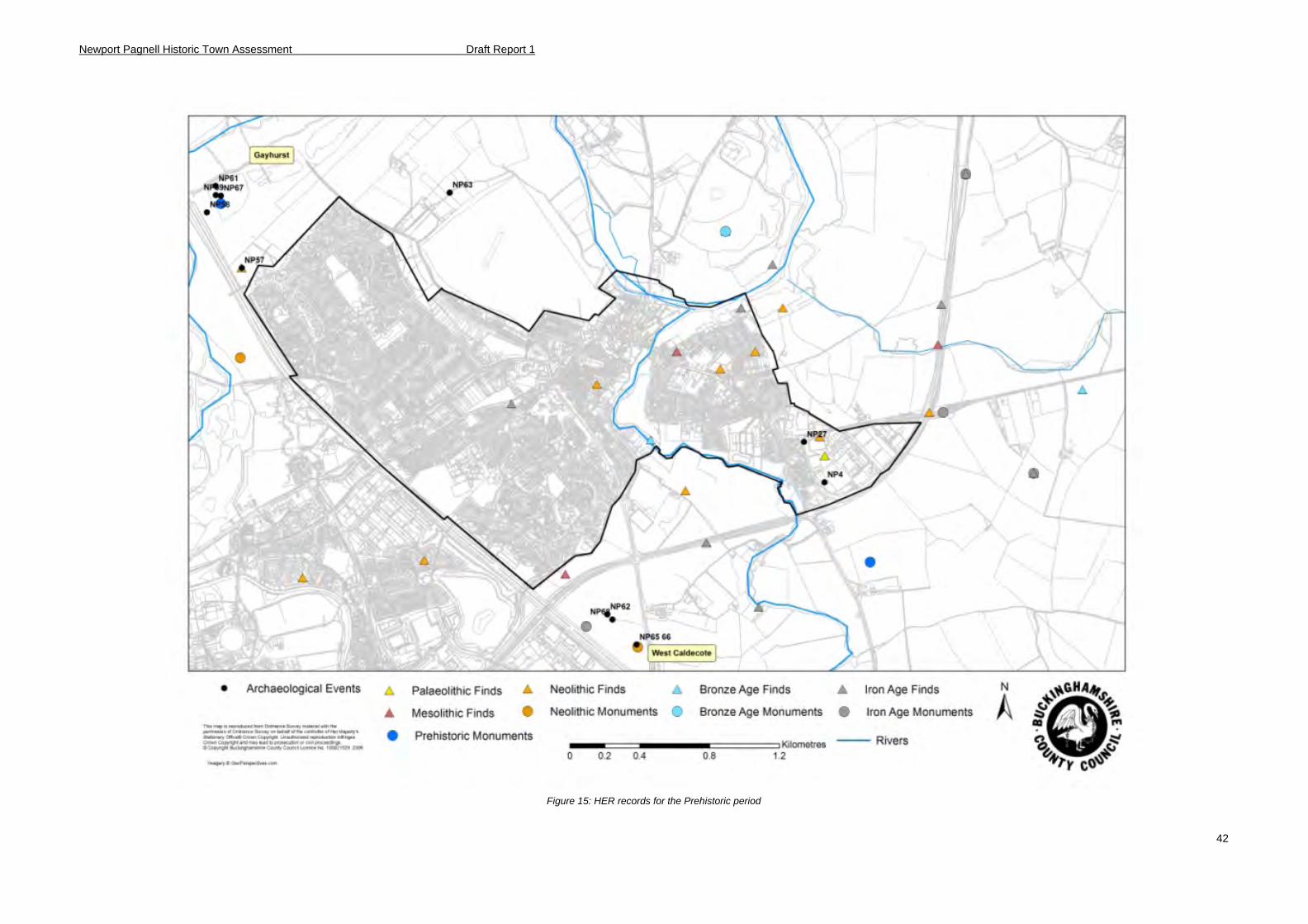
Newport Pagnell Historic Town Assessment Draft Report 1
42
Figure 15: HER records for the Prehistoric period
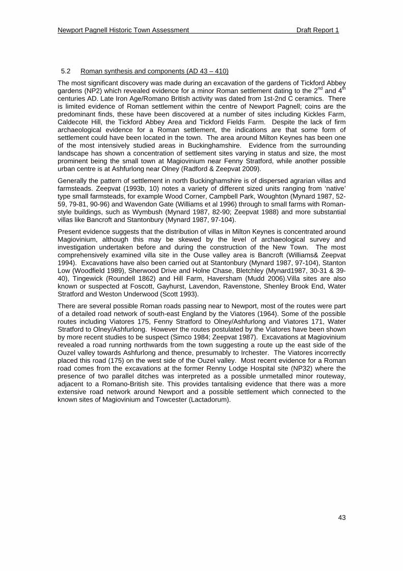
Newport Pagnell Historic Town Assessment Draft Report 1
43
5.2 Roman synthesis and components (AD 43 – 410)
The most significant discovery was made during an excavation of the gardens of Tickford Abbey gardens (NP2) which revealed evidence for a minor Roman settlement dating to the 2nd and 4th centuries AD. Late Iron Age/Romano British activity was dated from 1st-2nd C ceramics. There is limited evidence of Roman settlement within the centre of Newport Pagnell; coins are the predominant finds, these have been discovered at a number of sites including Kickles Farm, Caldecote Hill, the Tickford Abbey Area and Tickford Fields Farm. Despite the lack of firm archaeological evidence for a Roman settlement, the indications are that some form of settlement could have been located in the town. The area around Milton Keynes has been one of the most intensively studied areas in Buckinghamshire. Evidence from the surrounding landscape has shown a concentration of settlement sites varying in status and size, the most prominent being the small town at Magiovinium near Fenny Stratford, while another possible urban centre is at Ashfurlong near Olney (Radford & Zeepvat 2009).
Generally the pattern of settlement in north Buckinghamshire is of dispersed agrarian villas and farmsteads. Zeepvat (1993b, 10) notes a variety of different sized units ranging from ‘native’ type small farmsteads, for example Wood Corner, Campbell Park, Woughton (Mynard 1987, 52-59, 79-81, 90-96) and Wavendon Gate (Williams et al 1996) through to small farms with Roman-style buildings, such as Wymbush (Mynard 1987, 82-90; Zeepvat 1988) and more substantial villas like Bancroft and Stantonbury (Mynard 1987, 97-104).
Present evidence suggests that the distribution of villas in Milton Keynes is concentrated around Magiovinium, although this may be skewed by the level of archaeological survey and investigation undertaken before and during the construction of the New Town. The most comprehensively examined villa site in the Ouse valley area is Bancroft (Williams& Zeepvat 1994). Excavations have also been carried out at Stantonbury (Mynard 1987, 97-104), Stanton Low (Woodfield 1989), Sherwood Drive and Holne Chase, Bletchley (Mynard1987, 30-31 & 39-40), Tingewick (Roundell 1862) and Hill Farm, Haversham (Mudd 2006).Villa sites are also known or suspected at Foscott, Gayhurst, Lavendon, Ravenstone, Shenley Brook End, Water Stratford and Weston Underwood (Scott 1993).
There are several possible Roman roads passing near to Newport, most of the routes were part of a detailed road network of south-east England by the Viatores (1964). Some of the possible routes including Viatores 175, Fenny Stratford to Olney/Ashfurlong and Viatores 171, Water Stratford to Olney/Ashfurlong. However the routes postulated by the Viatores have been shown by more recent studies to be suspect (Simco 1984; Zeepvat 1987). Excavations at Magiovinium revealed a road running northwards from the town suggesting a route up the east side of the Ouzel valley towards Ashfurlong and thence, presumably to Irchester. The Viatores incorrectly placed this road (175) on the west side of the Ouzel valley. Most recent evidence for a Roman road comes from the excavations at the former Renny Lodge Hospital site (NP32) where the presence of two parallel ditches was interpreted as a possible unmetalled minor routeway, adjacent to a Romano-British site. This provides tantalising evidence that there was a more extensive road network around Newport and a possible settlement which connected to the known sites of Magiovinium and Towcester (Lactadorum).
Newport Pagnell Historic Town Assessment Draft Report 1
44
Figure 16: HER records for the Roman period
Newport Pagnell Historic Town Assessment Draft Report 1
45
5.3 Anglo Saxon synthesis and components (AD 410 – 1066)
Early-Middle Saxon
From archaeological evidence it is known that there was activity in and around Newport in the 6th and 7th centuries. There are three known Anglo Saxon cemeteries dating to around AD 500. The first cemetery was located in 1900 during ground digging behind the Union Workhouse in the London Road, SP 88774331 (Ballard 1900); several high status burials were found, the skeletons were placed in two concentric circles with the feet pointing towards the centre along with an assortment of grave goods, including swords, a spearhead and iron bucket, jewellery and elaborate late 5th century glass beaker of Rhenish origin. A second cemetery was discovered in 1923 when gravel digging in a field on Tickford Park Estate, just south of Chicheley Parish Boundary. In 1925 five or six more skeletons believed to be lying in an East-West position were found, a Saxon bead was discovered in a skull, and in another burial was a ring dated to the 6th century AD. Several of the burials were accompanied by grave goods of swords, spears and pottery (F W Bull 5, 1900). A third cemetery was found near Kickles Farm in the 1840s (HER 424301000) which also contained grave goods.
These burials predate the formation of the Mercian kingdom, during the 6th and 7th centuries AD. The modern counties of Surrey, Berkshire, Oxfordshire, Buckinghamshire and parts of Hertfordshire and Bedfordshire fell under the rule of several smaller Middle Angle tribes (Bailey K, 1994: 129). Although their exact boundaries are difficult to interpret, the Tribal Hidage has been used to estimate the extent of the tribal territories with varying degrees of success. Under the model put forward by Hart (1971) and later developed by Bailey (1994) Newport and its hundred fell under the rule of the Hendrica tribe whose territory included Buckingham, Bicester and Eynsham Hundreds but may also have extended north into Northamptonshire.
There have also been some stray finds including the discovery on the High Street of a coin of Offa, King of Mercia form 757-796 (Bull 1900). However the presence of these burials and isolated finds does not necessarily prove that Newport Pagnell was an early Saxon settlement, in all probability the present town was founded much later.
Late Saxon
Town Origins
The main historical evidence for the Late Saxon period comes from the short Domesday entry. Before the conquest Newport’s lord was Ulf, a king’s thegn and a housecarl (military retainer) of Edward the Confessor. It is known that burgage tenure already existed in Newport before 1086 so the foundation of the town is placed firmly in the Pre-Domesday period. Buckingham apart, Newport is the only other settlement in Buckinghamshire at this time to have documented borough status. Despite its status Newport was not a royal estate nor was it recorded as a burh unlike Aylesbury or Buckingham. As Baines (1986) observes it was unusual that Newport had a single lord who was not the king, as nearly all boroughs were in the king’s hands or administered on his behalf.
Based on the paucity of historical evidence, there has been some speculation about the town’s origins. One theory based upon the prevalence of Danish references in later documents is that Newport was originally a Danish foundation, located on the cusp of the lands of the Danelaw and those held by the Anglo Saxons (Baines 1986). However, another interpretation is that the settlement may be an Anglo Saxon creation; the Alfredian campaigns against Guthrum, and the subsequent treaty of AD 886 extended Anglo Saxon territorial domain to the Ouse beyond Watling Street. This would have placed Newport Pagnell at the edge of Saxon Mercia and the eastern part of the country under Danish control.
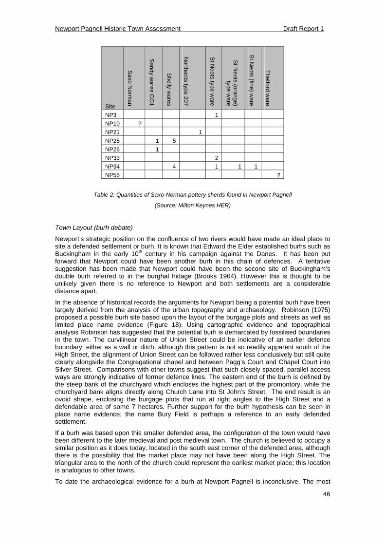
Newport Pagnell Historic Town Assessment Draft Report 1
46
Site
Saxo N
orman
Sandy w
ares CO
1
Shelly w
ares
Northa
nts type 207
St N
eots type ware
St N
eots (orange)
type ware
St N
eots (fine) ware
Thetford w
are NP3 1
NP10 ?
NP21 1
NP25 1 5
NP26 1
NP33 2
NP34 4 1 1 1
NP55 ?
Table 2: Quantities of Saxo-Norman pottery sherds found in Newport Pagnell
(Source: Milton Keynes HER)
Town Layout (burh debate)
Newport’s strategic position on the confluence of two rivers would have made an ideal place to site a defended settlement or burh. It is known that Edward the Elder established burhs such as Buckingham in the early 10th century in his campaign against the Danes. It has been put forward that Newport could have been another burh in this chain of defences. A tentative suggestion has been made that Newport could have been the second site of Buckingham’s double burh referred to in the burghal hidage (Brooks 1964). However this is thought to be unlikely given there is no reference to Newport and both settlements are a considerable distance apart.
In the absence of historical records the arguments for Newport being a potential burh have been largely derived from the analysis of the urban topography and archaeology. Robinson (1975) proposed a possible burh site based upon the layout of the burgage plots and streets as well as limited place name evidence (Figure 18). Using cartographic evidence and topographical analysis Robinson has suggested that the potential burh is demarcated by fossilised boundaries in the town. The curvilinear nature of Union Street could be indicative of an earlier defence boundary, either as a wall or ditch, although this pattern is not so readily apparent south of the High Street, the alignment of Union Street can be followed rather less conclusively but still quite clearly alongside the Congregational chapel and between Pagg’s Court and Chapel Court into Silver Street. Comparisons with other towns suggest that such closely spaced, parallel access ways are strongly indicative of former defence lines. The eastern end of the burh is defined by the steep bank of the churchyard which encloses the highest part of the promontory, while the churchyard bank aligns directly along Church Lane into St John’s Street. The end result is an ovoid shape, enclosing the burgage plots that run at right angles to the High Street and a defendable area of some 7 hectares. Further support for the burh hypothesis can be seen in place name evidence; the name Bury Field is perhaps a reference to an early defended settlement.
If a burh was based upon this smaller defended area, the configuration of the town would have been different to the later medieval and post medieval town. The church is believed to occupy a similar position as it does today, located in the south east corner of the defended area, although there is the possibility that the market place may not have been along the High Street. The triangular area to the north of the church could represent the earliest market place; this location is analogous to other towns.
To date the archaeological evidence for a burh at Newport Pagnell is inconclusive. The most
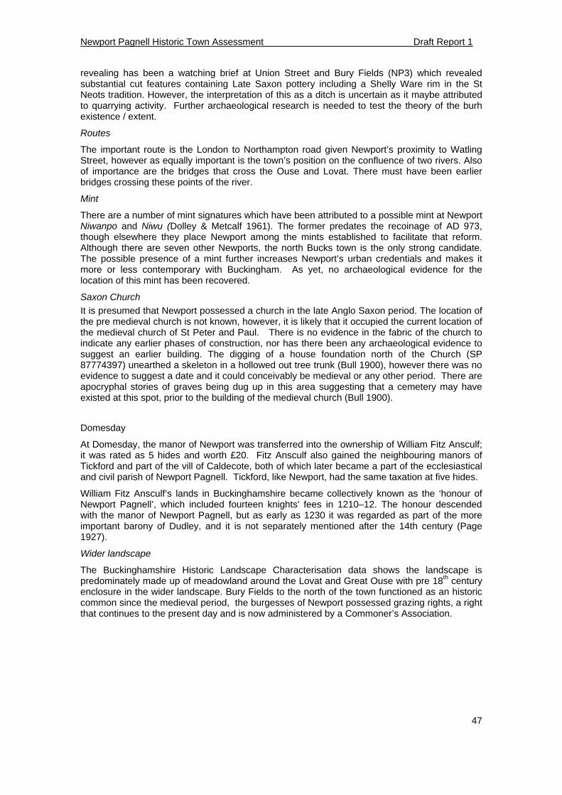
Newport Pagnell Historic Town Assessment Draft Report 1
47
revealing has been a watching brief at Union Street and Bury Fields (NP3) which revealed substantial cut features containing Late Saxon pottery including a Shelly Ware rim in the St Neots tradition. However, the interpretation of this as a ditch is uncertain as it maybe attributed to quarrying activity. Further archaeological research is needed to test the theory of the burh existence / extent.
Routes
The important route is the London to Northampton road given Newport’s proximity to Watling Street, however as equally important is the town’s position on the confluence of two rivers. Also of importance are the bridges that cross the Ouse and Lovat. There must have been earlier bridges crossing these points of the river.
Mint
There are a number of mint signatures which have been attributed to a possible mint at Newport Niwanpo and Niwu (Dolley & Metcalf 1961). The former predates the recoinage of AD 973, though elsewhere they place Newport among the mints established to facilitate that reform. Although there are seven other Newports, the north Bucks town is the only strong candidate. The possible presence of a mint further increases Newport’s urban credentials and makes it more or less contemporary with Buckingham. As yet, no archaeological evidence for the location of this mint has been recovered.
Saxon Church
It is presumed that Newport possessed a church in the late Anglo Saxon period. The location of the pre medieval church is not known, however, it is likely that it occupied the current location of the medieval church of St Peter and Paul. There is no evidence in the fabric of the church to indicate any earlier phases of construction, nor has there been any archaeological evidence to suggest an earlier building. The digging of a house foundation north of the Church (SP 87774397) unearthed a skeleton in a hollowed out tree trunk (Bull 1900), however there was no evidence to suggest a date and it could conceivably be medieval or any other period. There are apocryphal stories of graves being dug up in this area suggesting that a cemetery may have existed at this spot, prior to the building of the medieval church (Bull 1900).
Domesday
At Domesday, the manor of Newport was transferred into the ownership of William Fitz Ansculf; it was rated as 5 hides and worth £20. Fitz Ansculf also gained the neighbouring manors of Tickford and part of the vill of Caldecote, both of which later became a part of the ecclesiastical and civil parish of Newport Pagnell. Tickford, like Newport, had the same taxation at five hides.
William Fitz Ansculf’s lands in Buckinghamshire became collectively known as the ‘honour of Newport Pagnell’, which included fourteen knights' fees in 1210–12. The honour descended with the manor of Newport Pagnell, but as early as 1230 it was regarded as part of the more important barony of Dudley, and it is not separately mentioned after the 14th century (Page 1927).
Wider landscape
The Buckinghamshire Historic Landscape Characterisation data shows the landscape is predominately made up of meadowland around the Lovat and Great Ouse with pre 18th century enclosure in the wider landscape. Bury Fields to the north of the town functioned as an historic common since the medieval period, the burgesses of Newport possessed grazing rights, a right that continues to the present day and is now administered by a Commoner’s Association.
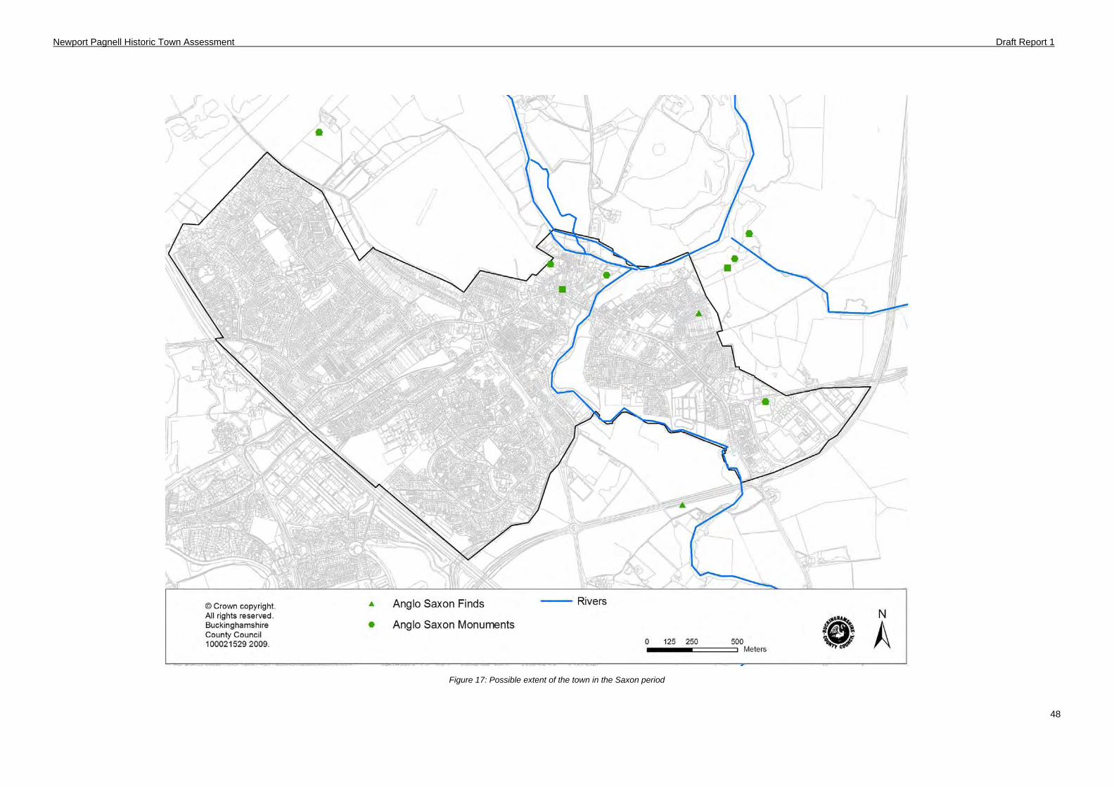
Newport Pagnell Historic Town Assessment Draft Report 1
48
Figure 17: Possible extent of the town in the Saxon period
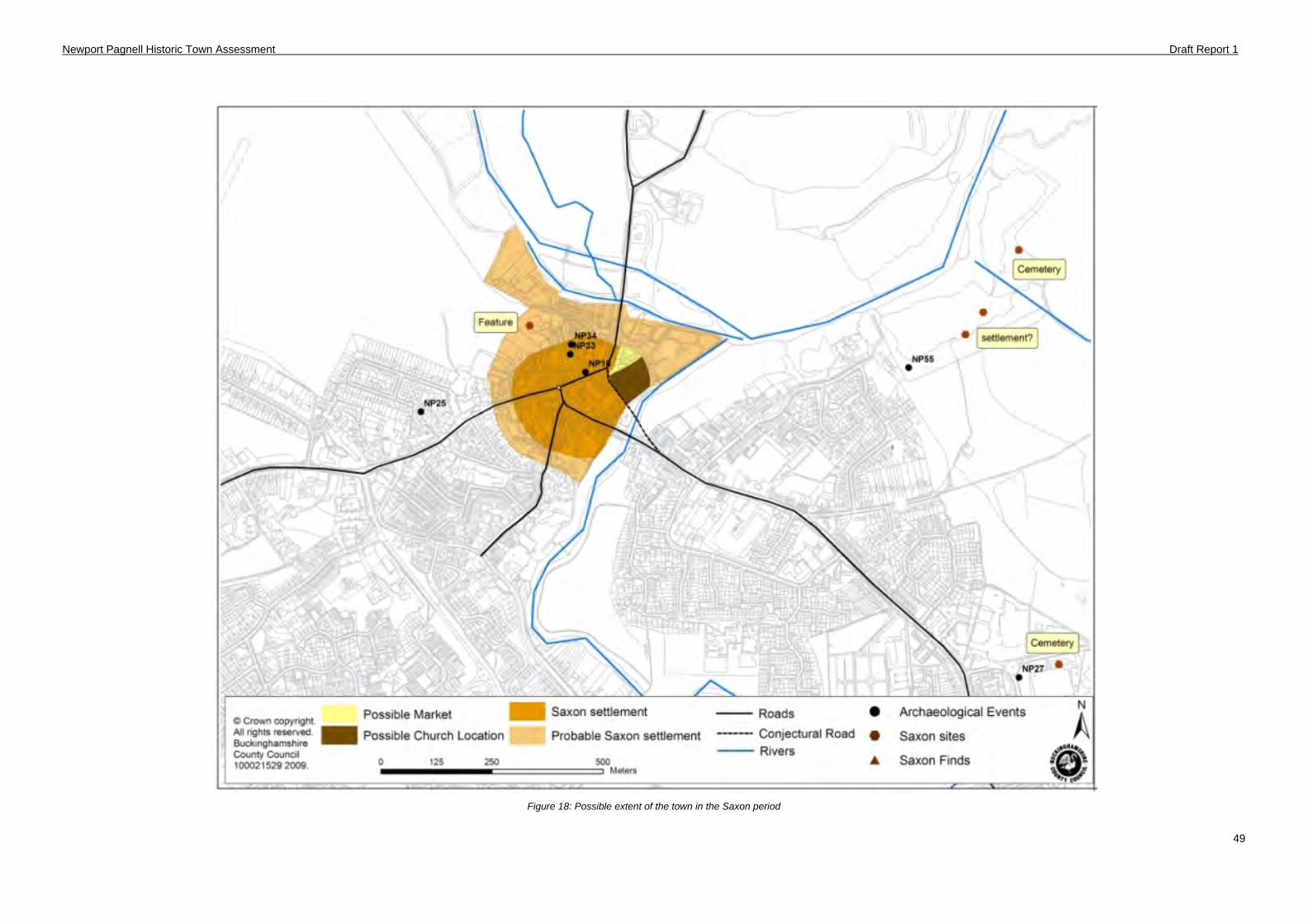
Newport Pagnell Historic Town Assessment Draft Report 1
49
Figure 18: Possible extent of the town in the Saxon period
Newport Pagnell Historic Town Assessment Draft Report 1
50
5.4 Medieval synthesis and components (1066-1536)
Documentary evidence for Newport Pagnell in the medieval period remains scarce, although it gives some indication of the extent of settlement at the close of the medieval period (Figure 23). As noted above, the main settlement area in the Saxon period is not well defined.
Manors
The following summaries are taken primarily from the Victoria County History and are limited in the data they provide, the history of the manors around Newport Pagnell are complex and a more detailed study is required to fully understand them. A complete catalogue of the available documentary evidence relating to medieval manors in Buckinghamshire is now available online via the National Archives Manorial Documents Registry produced in 2008 by the Centre for Buckinghamshire Studies and the National Archives. It is known that Newport Pagnell was divided into two principal manors in Newport and Tickford.
Newport Manor
Throughout the medieval period there was a succession of influential landed families who gained possession of the manor, largely by inheritance, marriage or sale. The most prominent of these include the Paynels, de Somerys and the Ormonds. Fulk Paynel gained the manors of Newport and Tickford by marriage in c.1100 after the death of William Fitz Ansculf. The Paynels were responsible for the establishment of the Priory at Tickford and if it existed, the castle at Newport. By the 14th century the manor and honour passed via several collateral lines of the de Somerys until it was inherited by the Earls of Ormond. Despite the manor changing hands during the Wars of the Roses the ownership returned to Thomas Ormond in 1485.
Tickford Manor
In the early 12th century Fulk Paynell granted the land from the manor to Cluniac monks to found the priory at Tickford. This conversion from a secular manor to ecclesiastical lands was to last the entirety of the medieval period.
Borough
The following information was derived from Victoria County History and the summary of documentation by Kim Taylor Moore (Appendix 1)
The Domesday entry shows that Newport’s borough was long established. It is not until the 13th century we have some idea of the borough’s population, in 1245 there were fifty-three burgage tenements recorded in the town. It is also known that the borough’s physical extent was marked by four boundary crosses (Page 1927). These crosses are thought to be placed at the entrances to the town, although only one of these locations, the junction of Priory Street with Tickford Street, can be fixed was any certainty (Figure 23). It is believed that one stood in the west part of the borough, while a natural site for a third would be the North Bridge (Page 1927). It appears that for much of the medieval period the borough was regarded as the urban part of the manor; the unbodmot - the borough court (known to be in existence from the 12th century), possessed the right to levy tolls for the bridge (portmote), and the market remained in the hands of the lord of the manor. The status of Newport’s borough is further underlined by the fact that the town did not send any representatives to Parliament unlike the smaller Buckinghamshire towns of Amersham and Wendover (Mynard & Hunt 1995). However by the 14th century there were some signs of development towards self-governance, in 1380 a grant of pontage was made to four named principal inhabitants of the town. A document of 1483 records the existence of a town guild of St Mary run by the burgesses (Baines 1987). The guild met in the Saracen’s Head which had been granted to them ‘for the maintenance of the bridges, amendment of the highways and the relief of the poor’ and acquired other property which became part of the charitable foundation known as ‘Town Lands’ and included almshouses that were located on the Green (Page 1927). By 1479 a bailiff, elected at the unbodmot, seems to be acting as a representative of the townsmen in dealings with the lord and was farming the tolls of the market and fair.
Newport Pagnell Historic Town Assessment Draft Report 1
51
Markets and Fairs
The market and fairs in Newport Pagnell were prescriptive, meaning that they were held by ancient right predating the first seigniorial grants of markets in the century. The rights to a market and fair in Newport Pagnell were already long established by 1245 when the miscellaneous rolls record that ‘Roger de Somery has a market in the borough and the jury do not know when or by what king it was granted’ (Mynard & Hunt 1995). Market day was a Saturday and the town had an annual fair on St Luke’s Day which continued for 6 days following. A second fair, on the Vigil and Feast of St Barnabas was granted in 1327, although this particular fair had superseded St. Luke’s fair by 1608 (Page 1927). It is also recorded in the 12th century that Gervase Paynell granted the monks of Tickford Abbey with special dispensation of trading without toll at the market. The market function of Newport Pagnell was the most important influence on the town. The town is situated on the junction of important roads and together with its neighbour, Stony Stratford, acted as the market centre for surrounding villages of the region. Newport also lies at the intersection of national routes leading from London to Northampton and the route from the West Midlands to Norwich and East Anglia.
Town layout
Newport is divided into two by the river Lovat, the area of the town that covers the supposed old burh along the high street developed and grew in importance, whereas the settlement to the south of the Lovat, Tickford End, was a settlement in its own right although potentially any growth here might have been curtailed after the 12th century by the founding of Tickford Priory.
It is believed that Newport’s market would have been held originally in front of the burgage plots in the High Street. The widening of the High Street at the western end from ‘the Green’, suggests that this area was also subsequently developed as a market place, perhaps for livestock, whilst the shape of North Square suggests that there may have been a third market area.
From plan form analysis of Ordnance Survey maps it is apparent that the boundaries of the burgage plots are curiously sinuous in shape (Figure 23). This may be an odd quirk of planning but one explanation is that boundaries correspond to the pattern of former open field strips. These strips had a characteristic curve or reverse ‘S’ which reflected the way the strips were originally ploughed (Mynard and Hunt 1993).
From examination of street plans in conjunction with known archaeological evidence it is possible to conjecture a phase of urban growth in Newport. If the original late Saxon settlement was confined to the ovoid shape (mentioned in 5.3), then the western end of the High Street and the southern end of Silver Street (formerly known as Marsh End) were probably suburban or ribbon development in the town. These accretions probably have their origin in the late thirteenth and early fourteenth centuries; pottery of this period having been found in these areas (NP25) & (NP26), although these suburban areas might well be older.
Archaeological evidence from the historic settlement is extensive, Table 3 summarises the main medieval pottery fabrics found either during archaeological work or as isolated finds. Medieval evidence for Potterspury wares and Brill Boarstall wares has been uncovered during several excavations including High Street (NP17) (NP19) (NP21) where medieval property boundaries, building foundations and numerous finds were recorded. There are accounts of substantial medieval finds discovered including pottery, identified as being of the 11th and 12th centuries found to the south of the former Priory. It has been conjectured that these finds signify a settlement that was lost when the priory took over the area in the 12th century. (Robinson 1975).
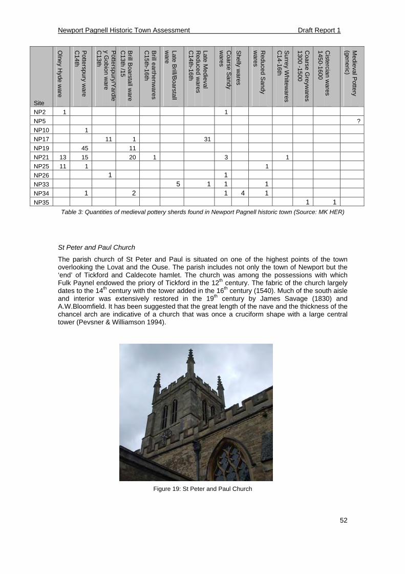
Newport Pagnell Historic Town Assessment Draft Report 1
52
Table 3: Quantities of medieval pottery sherds found in Newport Pagnell historic town (Source: MK HER)
St Peter and Paul Church
The parish church of St Peter and Paul is situated on one of the highest points of the town overlooking the Lovat and the Ouse. The parish includes not only the town of Newport but the ‘end’ of Tickford and Caldecote hamlet. The church was among the possessions with which Fulk Paynel endowed the priory of Tickford in the 12th century. The fabric of the church largely dates to the 14th century with the tower added in the 16th century (1540). Much of the south aisle and interior was extensively restored in the 19th century by James Savage (1830) and A.W.Bloomfield. It has been suggested that the great length of the nave and the thickness of the chancel arch are indicative of a church that was once a cruciform shape with a large central tower (Pevsner & Williamson 1994).
Figure 19: St Peter and Paul Church
Site
Olney H
yde ware
Potterspury w
are C
14th
Potterspury/Y
ardle
y Gobion w
are C
13th
Brill B
oarstall w
are C
13th /15
Brill earthen
wa
res C
15th-16th
Late Brill/B
oarstall w
are
Late Med
ieval R
educed w
ares
C14th-16th
Coarse S
andy
wares
Shelly w
ares
Red
uced Sand
y w
ares
Surrey W
hitewares
C14-16th
Coarse G
reywares
1300 -15
00
Cistercia
n wares
1450-16
00
Medieval P
ottery
(generic)
NP2 1 1
NP5 ?
NP10 1
NP17 11 1 31
NP19 45 11
NP21 13 15 20 1 3 1
NP25 11 1 1
NP26 1 1 NP33 5 1 1 1 NP34 1 2 1 4 1 NP35 1 1
Newport Pagnell Historic Town Assessment Draft Report 1
53
Castle
It is believed that Newport Pagnell once possessed a castle, the construction of which is attributed to the Paynels (and latterly the de Somerys) in the 12th century. However no positively attributable archaeological earthworks or physical remains have survived, nor is there any documentary evidence to suggest the date of establishment or the location of the site. The earliest reference to a castle dates to 1312 in a Charter of Commission when Castle Meadow is referred to (Sheehan 1862). If a there was a castle it is thought that it would have been the motte and bailey variety, and short lived, perhaps created during ‘the anarchy’ and soon after abandoned.
There have been several suggestions for the likely location of the castle. The traditional location is in the churchyard where a small mound has been attributed to a motte (Page 1927); this is also shown as the castle site on the Ordnance Survey’s 1st edition map. The cemetery area seems a suitable location for a castle with the rivers Ouse and Lovat acting as a defensive barrier to the north, east and south. However, this must be questioned as the area is low lying and prone to flooding. A second theory is that the castle was located at the top of the High Street on or near to St Peter and Paul’s church. This offers the highest vantage point in Newport and a castle would be able to control the traffic coming over the rivers. A third suggestion is that the fortification was in Castle Meadow itself; again this is a low lying area near the river Lovat and was completely levelled and landscaped in 1860 and nothing remains to be seen (Sheahan 1862).
An alternative hypothesis is that a castle didn’t exist at all and that in fact the castle was a fortified manor house. Since the Paynels and de Somerys were absentee lords, a large home may not have been needed. Upon the death of Roger de Somery in 1270 a survey was undertaken that describes his manor house as being a messuage with a dovehouse and garden although there is no mention of any defences (Page 1927). This house was possibly identical with the manor house called 'Waterhall,' which belonged to the St. German family in the 15th century, but in 1543 was surveyed with the demesne lands as the capital messuage of the manor. Similarly there is debate as to the location of the medieval manor house, one suggested location is placed at the end of town (even on the Brooklands House site) and that it later moved to the other end of the High Street (Bull 1900). Of all the other locations in the High Street only one is referred to in deeds of the 18th century as ‘Ancient Manor House’ although this could simply mean a house that belonged to the manor (Page 1927).
Tickford Priory
The Priory of St Mary the Virgin, Tickford was established circa 1100 by Fulk Paynel. This was a dependent cell of a Cluniac monastery of Marmoutier, Tours. Land was granted by Fulk Paynel on each side of Monechustret, lands and tenements in Hawstreet. The interpretation of this document is that the priory owned the plots of land on the east side of St John’s Street together with the administration of the church. The lands and tenements before the gate house and meadow called Castelmeade (Lewis 1993). The extent of the priory ran along the bank of the river Lovat. There is no real evidence for a precinct but it could be delineated by the river to the north and at its southern extent by Priory Street. It is known that the Priory was treated favourably as in 1187 the monks were granted freedom from Newport’s market tolls, and were gifted land in several neighbouring villages including one virgate of land and Caldecote mill along the Lovat, and the right to collect tithes of the whole parish of Newport (Lewis 1993). The Priory also gained advowson (the right to appoint the priest) at the parish church. As a consequence the priory had considerable influence on the town.
Despite this generous patronage the Priory’s history was beset with problems including: a fire and a scandalous administration in the 13th century; its repression during the Hundred Years War when alien houses were prevented from sending funds to mother houses in France. (Lewis 1993). The Priory was transferred to Holy Trinity Priory, York, in 1426 but by then its wealth and influence had waned. The priory was finally surrendered to the crown in 1525 and the assets diverted to fund Cardinal Wolsey’s new college in Oxford.
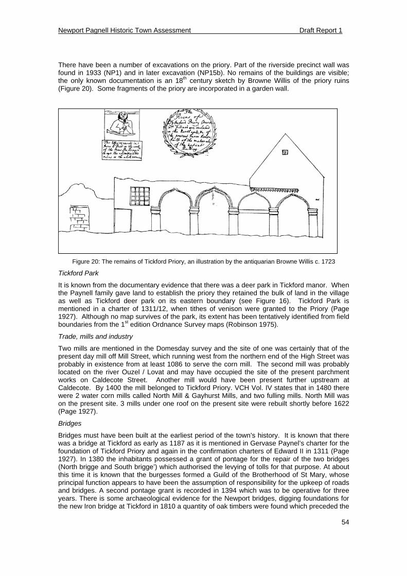
Newport Pagnell Historic Town Assessment Draft Report 1
54
There have been a number of excavations on the priory. Part of the riverside precinct wall was found in 1933 (NP1) and in later excavation (NP15b). No remains of the buildings are visible; the only known documentation is an 18th century sketch by Browne Willis of the priory ruins (Figure 20). Some fragments of the priory are incorporated in a garden wall.
Figure 20: The remains of Tickford Priory, an illustration by the antiquarian Browne Willis c. 1723
Tickford Park
It is known from the documentary evidence that there was a deer park in Tickford manor. When the Paynell family gave land to establish the priory they retained the bulk of land in the village as well as Tickford deer park on its eastern boundary (see Figure 16). Tickford Park is mentioned in a charter of 1311/12, when tithes of venison were granted to the Priory (Page 1927). Although no map survives of the park, its extent has been tentatively identified from field boundaries from the 1st edition Ordnance Survey maps (Robinson 1975).
Trade, mills and industry
Two mills are mentioned in the Domesday survey and the site of one was certainly that of the present day mill off Mill Street, which running west from the northern end of the High Street was probably in existence from at least 1086 to serve the corn mill. The second mill was probably located on the river Ouzel / Lovat and may have occupied the site of the present parchment works on Caldecote Street. Another mill would have been present further upstream at Caldecote. By 1400 the mill belonged to Tickford Priory. VCH Vol. IV states that in 1480 there were 2 water corn mills called North Mill & Gayhurst Mills, and two fulling mills. North Mill was on the present site. 3 mills under one roof on the present site were rebuilt shortly before 1622 (Page 1927).
Bridges
Bridges must have been built at the earliest period of the town’s history. It is known that there was a bridge at Tickford as early as 1187 as it is mentioned in Gervase Paynel’s charter for the foundation of Tickford Priory and again in the confirmation charters of Edward II in 1311 (Page 1927). In 1380 the inhabitants possessed a grant of pontage for the repair of the two bridges (North brigge and South brigge’) which authorised the levying of tolls for that purpose. At about this time it is known that the burgesses formed a Guild of the Brotherhood of St Mary, whose principal function appears to have been the assumption of responsibility for the upkeep of roads and bridges. A second pontage grant is recorded in 1394 which was to be operative for three years. There is some archaeological evidence for the Newport bridges, digging foundations for the new Iron bridge at Tickford in 1810 a quantity of oak timbers were found which preceded the
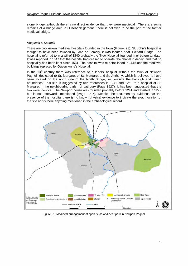
Newport Pagnell Historic Town Assessment Draft Report 1
55
stone bridge, although there is no direct evidence that they were medieval. There are some remains of a bridge arch in Ousebank gardens; there is believed to be the part of the former medieval bridge.
Hospitals & Schools
There are two known medieval hospitals founded in the town (Figure. 23). St. John’s hospital is thought to have been founded by John de Somery, it was located near Tickford Bridge. The hospital is referred to in a will of 1240 probably the `New Hospital' founded in or before tat date. It was reported in 1547 that the hospital had ceased to operate, the chapel in decay, and that no hospitality had been kept since 1531. The hospital was re-established in 1615 and the medieval buildings replaced by Queen Anne’s Hospital.
In the 13th century there was reference to a lepers' hospital 'without the town of Newport Pagnell' dedicated to St. Margaret or St. Margaret and St. Anthony, which is believed to have been located on the north side of the North Bridge, just outside the borough and parish boundaries. This site is suggested by two references in 1241 and 1252 to a hospital of St. Margaret in the neighbouring parish of Lathbury (Page 1927). It has been suggested that the two were identical. The Newport house was founded probably before 1241 and existed in 1272 but is not afterwards mentioned (Page 1927). Despite the documentary evidence for the presence of the hospital there is no known physical evidence to indicate the exact location of the site nor is there anything mentioned in the archaeological record.
Figure 21: Medieval arrangement of open fields and deer park in Newport Pagnell
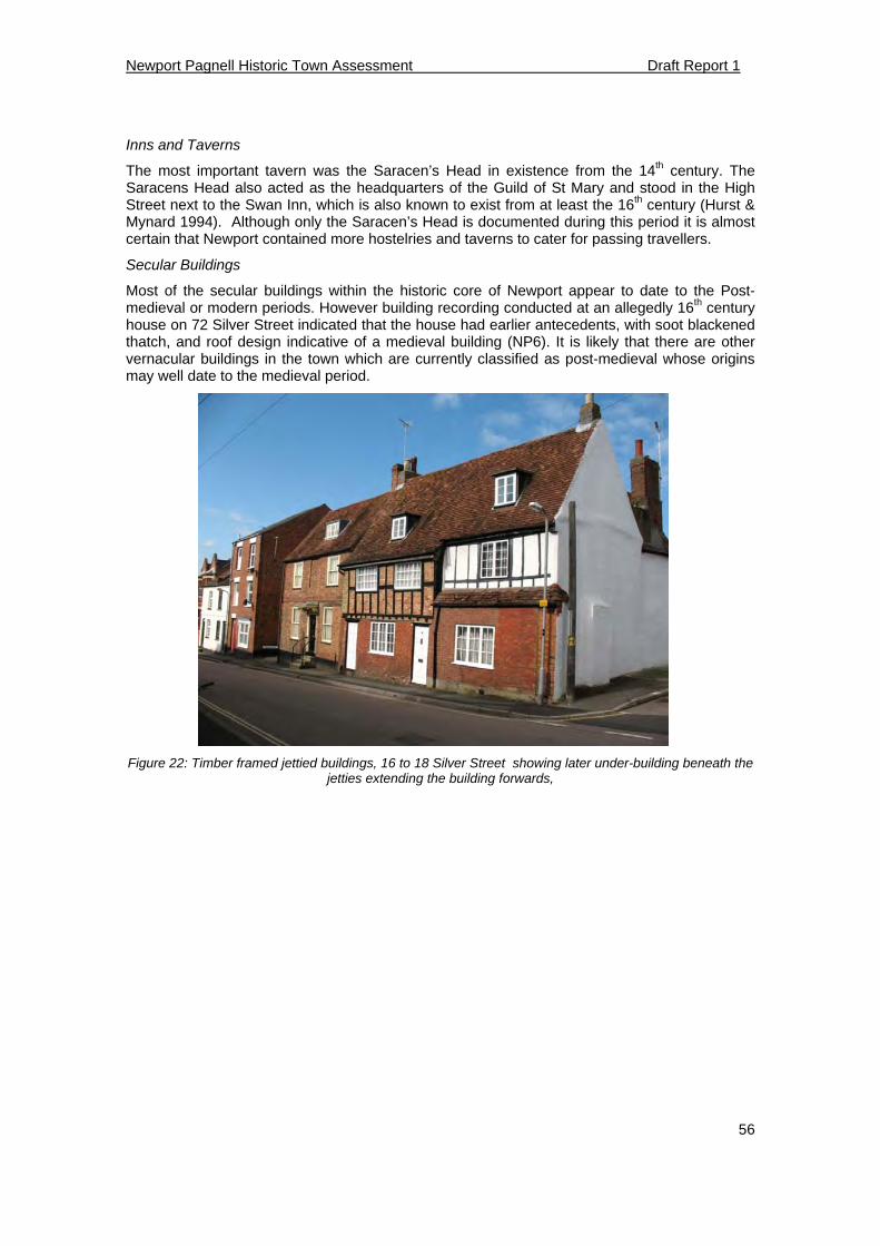
Newport Pagnell Historic Town Assessment Draft Report 1
56
Inns and Taverns
The most important tavern was the Saracen’s Head in existence from the 14th century. The Saracens Head also acted as the headquarters of the Guild of St Mary and stood in the High Street next to the Swan Inn, which is also known to exist from at least the 16th century (Hurst & Mynard 1994). Although only the Saracen’s Head is documented during this period it is almost certain that Newport contained more hostelries and taverns to cater for passing travellers.
Secular Buildings
Most of the secular buildings within the historic core of Newport appear to date to the Post- medieval or modern periods. However building recording conducted at an allegedly 16th century house on 72 Silver Street indicated that the house had earlier antecedents, with soot blackened thatch, and roof design indicative of a medieval building (NP6). It is likely that there are other vernacular buildings in the town which are currently classified as post-medieval whose origins may well date to the medieval period.
Figure 22: Timber framed jettied buildings, 16 to 18 Silver Street showing later under-building beneath the jetties extending the building forwards,
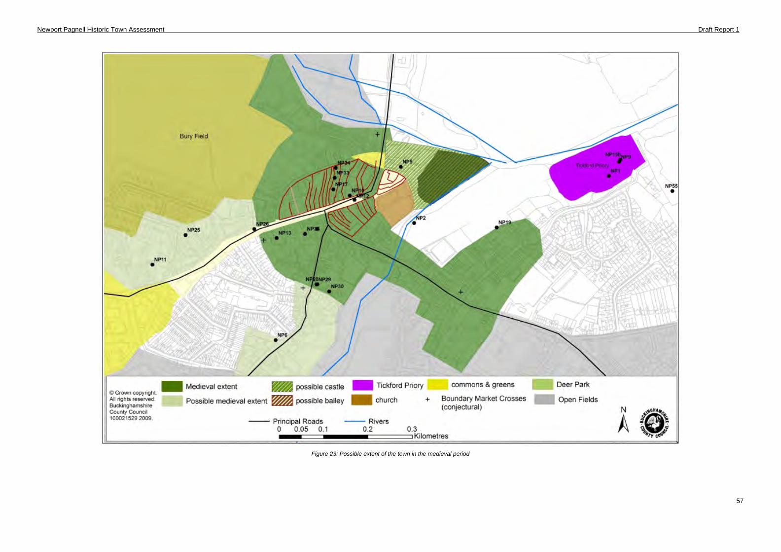
Newport Pagnell Historic Town Assessment Draft Report 1
57
Figure 23: Possible extent of the town in the medieval period
Newport Pagnell Historic Town Assessment Draft Report 1
58
5.5 Post medieval synthesis and components (1536-1800)
Manor
In 1542 Newport manor came under the ownership of the Crown when George St Leger exchanged the manor for lands in Devonshire. The manor was a royal possession until James I sold it to Francis Annesley in 1627; Annesley’s heirs, or as they became after 1661 the Earls Anglesey, were the lords of the manor until 1810. (Page 1927)
Tickford Priory and Tickford Abbey
Tickford Priory had been established since the 12th century but its life came to end in 1545 with the suppression of the monasteries by Henry VIII. There was a brief period when revenues went to Cardinal Wolsey’s new college at Oxford, thereafter it became Crown property and was sold to Henry Atkins, the royal physician, in 1600. The remains of Tickford Priory stayed with the Atkins family until the site was sold in 1757 to John Hooton, a local gentleman farmer. Hooton’s son Thomas built the present house called Tickford Abbey. Several members of the Hooton family are buried in a private vault within the grounds.
Deer Park
The deer park at Tickford had long been a part of the manorial lands of Newport but in 1600 the deer park was sold to Sir John Fortescue of Salden. It was sold on again in 1620 to Sir Henry Atkins who owned land around Tickford Priory. A survey at the time shows that the park still had a stock of deer and was enclosed by a stone boundary. However the Atkins family had other interests in how the land was managed and the wood was cleared and the park divided into enclosures (Bull 1900).
Town layout
Civil War
One of the most profound episodes in the town’s history was the English Civil War. The strategic importance of Newport Pagnell was recognised during the conflict. Prince Rupert occupied the town in the autumn of 1643 and gave orders for building entrenchments. Rather inexplicably, the royalists abandoned the town and parliamentary forces moved in. By the end of 1643 Parliament set about fortifying the town. The construction of the defences came at a great expense, £1,000 levied from the counties of Bedford, Hertfordshire, Northampton, Huntingdon Cambridge, Suffolk Essex and Norfolk so ‘that the town of Newport shall be strongly fortified and furnished with all necessary provisions for a garrison’. The map of the fortifications for the parliamentary garrison by Vandenboome is perhaps the earliest map of Newport (Figure 5). It shows the town naturally protected by the rivers Ouse and Lovat, was to be further defended by digging a 10ft deep ditch and a 10ft high bank all around the built up area. There were bulwarks on the Ouse, the Mount Bulwark where the rivers meet, and the Tannery Bulwark between Silver Street (there called Marsh Street) and the river Lovat. The map depicts the market buildings which were positioned in the centre of the High Street between the church and St John Street. These have been interpreted as being present in a watching brief (NP25).
Despite the substantial nature of the defences, surprisingly little of it survives today. The best preserved earthworks of the ditch are found to the northeast of the town, this is protected as a scheduled ancient monument (SAM No. 35922). In terms of the town morphology the fortifications do not appear to have much of an impact on the overall plan of the town. An approximation of the layout and extent of the defences based on Vandenboome’s drawing has been interpreted by Paul Woodfield and plotted by Brian Giggins (Figure 25). None of the walls have been preserved in boundaries or roads in the town plan. The only surviving physical evidence has come from archaeological watching briefs in the High Street, which revealed what are thought to be sections of the defensive ditch (NP11 and NP12). However, other interventions along the projected line of the defences have failed to find any evidence of ditches (NP42) (NP50). The lack of surviving fortifications can be attributed to their deliberate destruction after the conflict to prevent further reoccupation of the town. Despite the dearth of archaeological evidence there is some potential for the survival of buried earthworks and ditch at Ousebank Street. Given the negative results of some archaeological interventions there has to be some question as to how extensive the Civil War defences actually were at Newport and
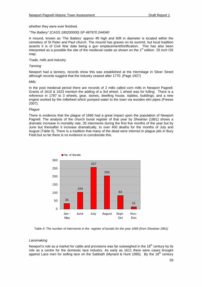
Newport Pagnell Historic Town Assessment Draft Report 1
59
whether they were ever finished.
"The Battery" (CASS 180200000) SP 487970 244040
A mound, known as ‘The Battery’ approx 4ft high and 60ft in diameter is located within the cemetery of St Peter and Paul church. The mound has graves on its summit, but local tradition asserts it is of Civil War date being a gun emplacement/fortification. This has also been interpreted as a possible the site of the medieval castle as shown on the 1st edition 25 inch OS map.
Trade, mills and industry
Tanning
Newport had a tannery, records show this was established at the Hermitage in Silver Street although records suggest that the industry ceased after 1770. (Page 1927)
Mills
In the post medieval period there are records of 2 mills called corn mills in Newport Pagnell. Grants of 1610 & 1623 mention the adding of a 3rd wheel; 1 wheel was for fulling. There is a reference in 1787 to 3 wheels, gear, stones, dwelling house, stables, buildings; and a new engine worked by the millwheel which pumped water to the town via wooden elm pipes (Freese 2007).
Plague
There is evidence that the plague of 1666 had a great impact upon the population of Newport Pagnell. The analysis of the church burial register of that year by Sheahan (1861) shows a dramatic increase in mortality rate, 35 interments during the first five months of the year but by June but thereafter it increase dramatically, to over 400 deaths for the months of July and August (Table 5). There is a tradition that many of the dead were interred in plague pits in Bury Field but so far there is no evidence to corroborate this.
35
104
257
205
83
15
0
50
100
150
200
250
300
Jan -May
June July August Sept -Oct
Nov -Dec
No. of Burials
Table 4: The number of interments in the register of burials for the year 1666 (from Sheahan 1861)
Lacemaking
Newport’s role as a market for cattle and provisions was far outweighed in the 18th century by its role as a centre for the domestic lace industry. As early as 1611 there were cases brought against Lace men for selling lace on the Sabbath (Mynard & Hunt 1995). By the 18th century
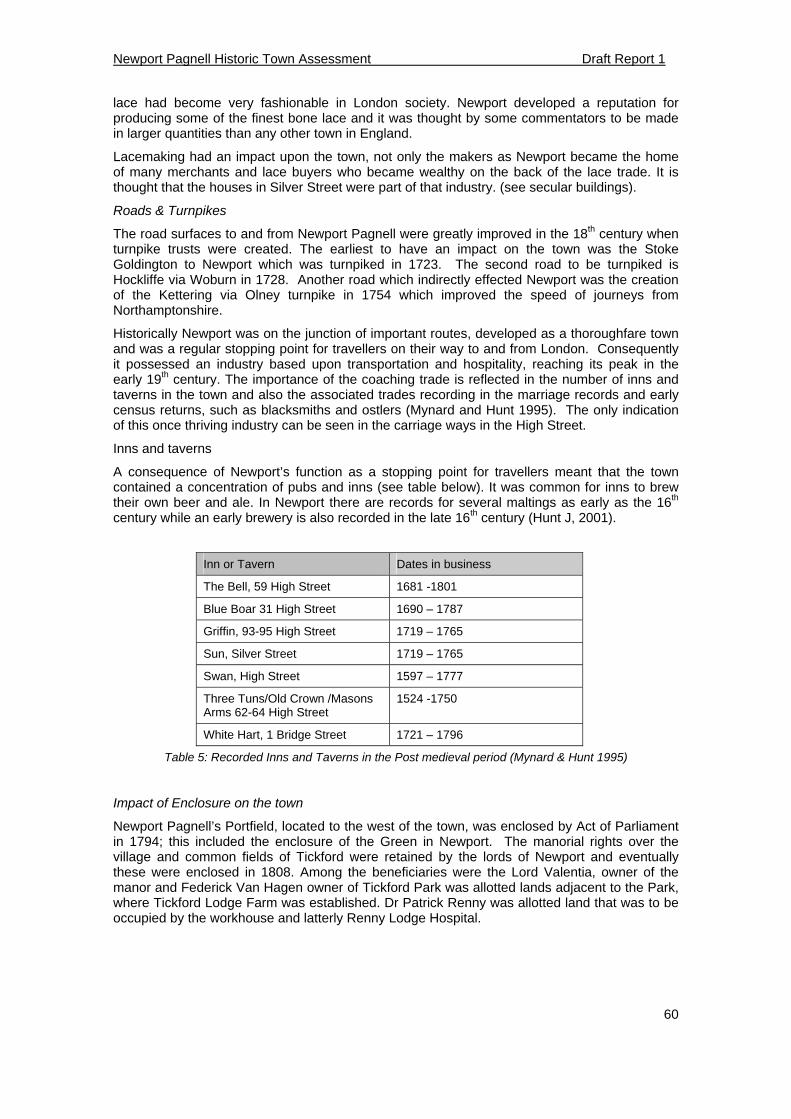
Newport Pagnell Historic Town Assessment Draft Report 1
60
lace had become very fashionable in London society. Newport developed a reputation for producing some of the finest bone lace and it was thought by some commentators to be made in larger quantities than any other town in England.
Lacemaking had an impact upon the town, not only the makers as Newport became the home of many merchants and lace buyers who became wealthy on the back of the lace trade. It is thought that the houses in Silver Street were part of that industry. (see secular buildings).
Roads & Turnpikes
The road surfaces to and from Newport Pagnell were greatly improved in the 18th century when turnpike trusts were created. The earliest to have an impact on the town was the Stoke Goldington to Newport which was turnpiked in 1723. The second road to be turnpiked is Hockliffe via Woburn in 1728. Another road which indirectly effected Newport was the creation of the Kettering via Olney turnpike in 1754 which improved the speed of journeys from Northamptonshire.
Historically Newport was on the junction of important routes, developed as a thoroughfare town and was a regular stopping point for travellers on their way to and from London. Consequently it possessed an industry based upon transportation and hospitality, reaching its peak in the early 19th century. The importance of the coaching trade is reflected in the number of inns and taverns in the town and also the associated trades recording in the marriage records and early census returns, such as blacksmiths and ostlers (Mynard and Hunt 1995). The only indication of this once thriving industry can be seen in the carriage ways in the High Street.
Inns and taverns
A consequence of Newport’s function as a stopping point for travellers meant that the town contained a concentration of pubs and inns (see table below). It was common for inns to brew their own beer and ale. In Newport there are records for several maltings as early as the 16th century while an early brewery is also recorded in the late 16th century (Hunt J, 2001).
Inn or Tavern Dates in business
The Bell, 59 High Street 1681 -1801
Blue Boar 31 High Street 1690 – 1787
Griffin, 93-95 High Street 1719 – 1765
Sun, Silver Street 1719 – 1765
Swan, High Street 1597 – 1777
Three Tuns/Old Crown /Masons Arms 62-64 High Street
1524 -1750
White Hart, 1 Bridge Street 1721 – 1796
Table 5: Recorded Inns and Taverns in the Post medieval period (Mynard & Hunt 1995)
Impact of Enclosure on the town
Newport Pagnell’s Portfield, located to the west of the town, was enclosed by Act of Parliament in 1794; this included the enclosure of the Green in Newport. The manorial rights over the village and common fields of Tickford were retained by the lords of Newport and eventually these were enclosed in 1808. Among the beneficiaries were the Lord Valentia, owner of the manor and Federick Van Hagen owner of Tickford Park was allotted lands adjacent to the Park, where Tickford Lodge Farm was established. Dr Patrick Renny was allotted land that was to be occupied by the workhouse and latterly Renny Lodge Hospital.
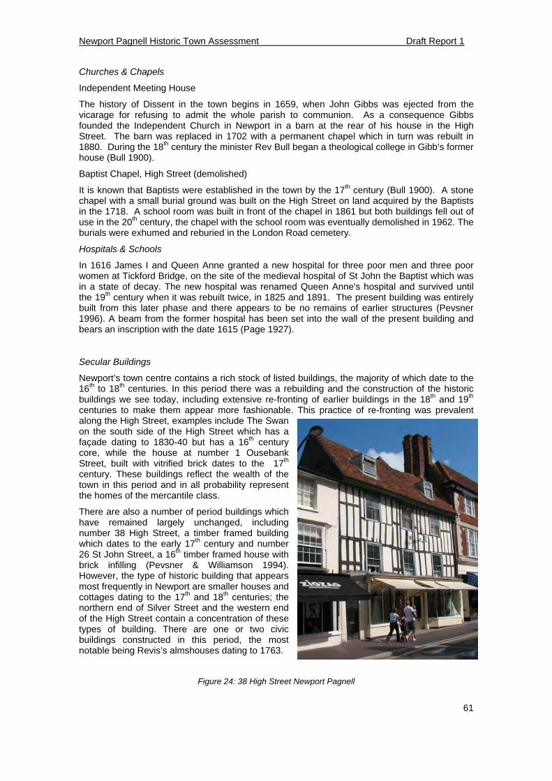
Newport Pagnell Historic Town Assessment Draft Report 1
61
Churches & Chapels
Independent Meeting House
The history of Dissent in the town begins in 1659, when John Gibbs was ejected from the vicarage for refusing to admit the whole parish to communion. As a consequence Gibbs founded the Independent Church in Newport in a barn at the rear of his house in the High Street. The barn was replaced in 1702 with a permanent chapel which in turn was rebuilt in 1880. During the 18th century the minister Rev Bull began a theological college in Gibb’s former house (Bull 1900).
Baptist Chapel, High Street (demolished)
It is known that Baptists were established in the town by the 17th century (Bull 1900). A stone chapel with a small burial ground was built on the High Street on land acquired by the Baptists in the 1718. A school room was built in front of the chapel in 1861 but both buildings fell out of use in the 20th century, the chapel with the school room was eventually demolished in 1962. The burials were exhumed and reburied in the London Road cemetery.
Hospitals & Schools
In 1616 James I and Queen Anne granted a new hospital for three poor men and three poor women at Tickford Bridge, on the site of the medieval hospital of St John the Baptist which was in a state of decay. The new hospital was renamed Queen Anne's hospital and survived until the 19th century when it was rebuilt twice, in 1825 and 1891. The present building was entirely built from this later phase and there appears to be no remains of earlier structures (Pevsner 1996). A beam from the former hospital has been set into the wall of the present building and bears an inscription with the date 1615 (Page 1927).
Secular Buildings
Newport’s town centre contains a rich stock of listed buildings, the majority of which date to the 16th to 18th centuries. In this period there was a rebuilding and the construction of the historic buildings we see today, including extensive re-fronting of earlier buildings in the 18th and 19th centuries to make them appear more fashionable. This practice of re-fronting was prevalent along the High Street, examples include The Swan on the south side of the High Street which has a façade dating to 1830-40 but has a 16th century core, while the house at number 1 Ousebank Street, built with vitrified brick dates to the 17th century. These buildings reflect the wealth of the town in this period and in all probability represent the homes of the mercantile class.
There are also a number of period buildings which have remained largely unchanged, including number 38 High Street, a timber framed building which dates to the early 17th century and number 26 St John Street, a 16th timber framed house with brick infilling (Pevsner & Williamson 1994). However, the type of historic building that appears most frequently in Newport are smaller houses and cottages dating to the 17th and 18th centuries; the northern end of Silver Street and the western end of the High Street contain a concentration of these types of building. There are one or two civic buildings constructed in this period, the most notable being Revis’s almshouses dating to 1763.
Figure 24: 38 High Street Newport Pagnell
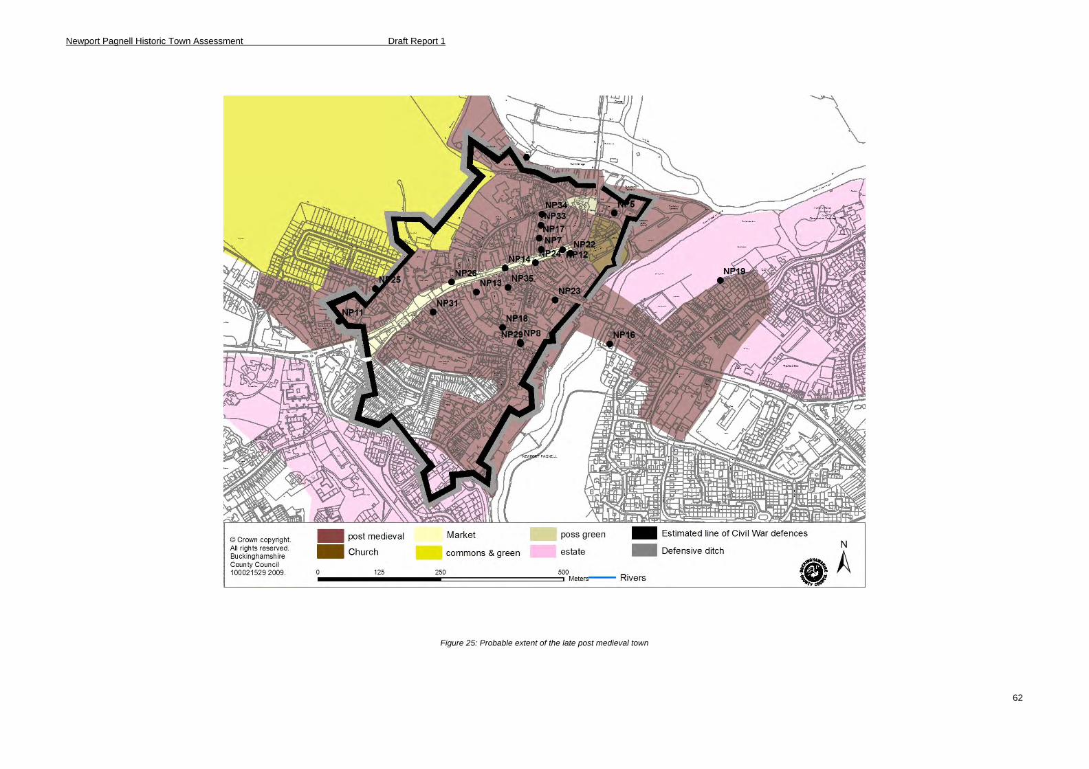
Newport Pagnell Historic Town Assessment Draft Report 1
62
Figure 25: Probable extent of the late post medieval town

Newport Pagnell Historic Town Assessment Draft Report 1
63
5.6 Modern synthesis and components (1800-Present)
Manors & Estates
Newport Pagnell remained in the hands the descendants of the earls of Anglesey until 1810 when ownership of the manor passed to Charles Marius Hardy, a local surgeon. Thereafter Newport was in the ownership of a number of landowners most notably the Powells and the Van Hagens.
Industry in the 19th Century (see Appendix 4 for details)
Brewing and Malting
In the late 18th century Newport had a corn market at which numerous local maltsters were selling large quantities of malt to local inns. The 18th century saw a trend of maltsters becoming brewers and buying up local inns so that they could supply them with beer brewed on site. In the 1780s, Thomas Meacher, a maltster from Ivinghoe set up a brewery on the High Street to supply his pubs including the neighbouring Dolphin Inn. In 1811 Meacher’s bankruptcy forced him to sell the brewery, it was eventually acquired by a local doctor, John Rogers and the brewery and pubs remained in the family until 1875 when it was sold to Messrs Allfrey & Lovell. The brewery expanded and became known as the Newport Pagnell Brewery Company but was eventually purchased by Bedford brewers Charles Wells & Co who closed the brewery in 1919 (Mynard & Hunt 1995). The vacant brewery site became the location of Cooper’s farm machinery works in 1924, and the buildings were converted to show rooms. The brewery buildings were eventually demolished in 1995 to make way for Newport Pagnell’s medical centre.
Although the Newport brewery was the principal producer of beer in the town, Green & Co established a brewery at Shipley Wharf which was short lived and lasted until 1850. The 1851 Census identifies 10 brewers including 2 that cannot be linked to a particular site; many are thought to have supplied the brew to other hostelries in the town. One of these smaller maltings was located at Admiral Hood, St John’s Street, the buildings of which survived until the 1950s (Brown 2007).
Newport Mill
In the mid 19th century a steam engine was added to Newport Mill. The majority of buildings were destroyed by fire in 1880, although it was rebuilt as a five storey mill building equipped with new machinery. Unfortunately the new mill was again beset by disaster when it was destroyed by another fire in 1899. The mill never recovered from the second fire and the remaining buildings were demolished and replace by a private residence and garden.
Figure 26: Newport Mill c. 1880 - 1899
Newport Pagnell Historic Town Assessment Draft Report 1
64
Fulling Mill
The 1806 2 inch Ordnance Survey Surveyor’s map shows a fulling mill straddling the river at the edge of Red House Meadow. Between Silver Street and River on the north side of Caldecote Street was a close called "Mill Close". These may indicate that this was a brick building with lands extending up to Silver Street. The course of river at this point has been infilled and the site is within the meadow on the east side of the river.
Parchment Industry
The making of parchment was a supporting trade to the lace industry. The first known reference to parchment making in Newport is found in the town’s 1792 directory although parchment was probably made in the Newport area when the Lace industry prospered. Parchment is made from sheep skins which are stretched on a frame, scraped smooth and treated with chemicals then left to dry out in the open air for several days. The William Cowley Parchment Works still operates from premises on Caldecote Street as they have done since the late 19th century. The firm is the sole parchment maker remaining in the UK and supplies HM Government with parchment on which new statutes are inscribed. A small-scale archaeological investigation and historic building recording have recently been undertaken on the site (Keir, 2010; Meckseper & Cooper–Reade, 2010).
Summary 1830 1844 1853 1864 1877 1883 1895 1903 1911 1920 1935
Professional 12 16 19 16 7 12 9 7 15 14 19
Agric/General 1 1 14 7 6 6 8 12 11 8 17
Artisans/trades 37 44 59 39 36 27 34 28 27 21 15
Service/Provision 103 125 134 116 101 102 98 89 91 70 63
Merchant/dealer 49 64 95 55 48 57 67 56 66 52 64
Table 6: Summary of trade in Newport Pagnell 1830-1935 (method adapted from Broad, 1992)
Taylor's Mustard Works, Union Street (CASS 821000000)
The premises were acquired in 1830 by William Taylor who started out producing soda water, lithium water and seltzers. The water was sourced from a well on the premises. However the company became famous for its production of mustard. Mustard ceased to be made on the site in 1990 when the company relocated to Cheshire.
Tickford Brickworks (CASS 487800101)
The availability of Oxford Clay in the Newport area made it a suitable area for the production of bricks. It is believed that brickmaking in a piecemeal fashion had occurred in the town for centuries; many of the town’s houses having been constructed from bricks produced from the clay in the gardens and surrounding fields (Markham 1975). However it wasn’t until the 19th century that mechanised mass production killed off itinerant brickmaking. In Newport there were three principal brickyards, at Tickford End, Broughton Road and at Shipley Wharf. Broughton Road: The earliest reference to the yard is 1830; the owner was William Yates with a brick field adjacent. Bricks from the site are known to have been used to build the Bury Street School and houses in Bury Street, Greenfield Road, Bury Avenue and Lovat Street. The yard seems to have been in operation until the early 20th century (Pike 1995). Tickford: Records of a brickyard at Tickford date from 1842, although brickmaking seems to have a long association in this area with several clay extraction pits including Chicheley Street (Clay lane), which produced large quantities. It is known that in 1851 Great Woolstone Rectory was constructed from bricks from the Tickford yard (Markham 1975). Shipley Wharf: A brickyard was located at Shipley Wharf near Green End from at least 1830
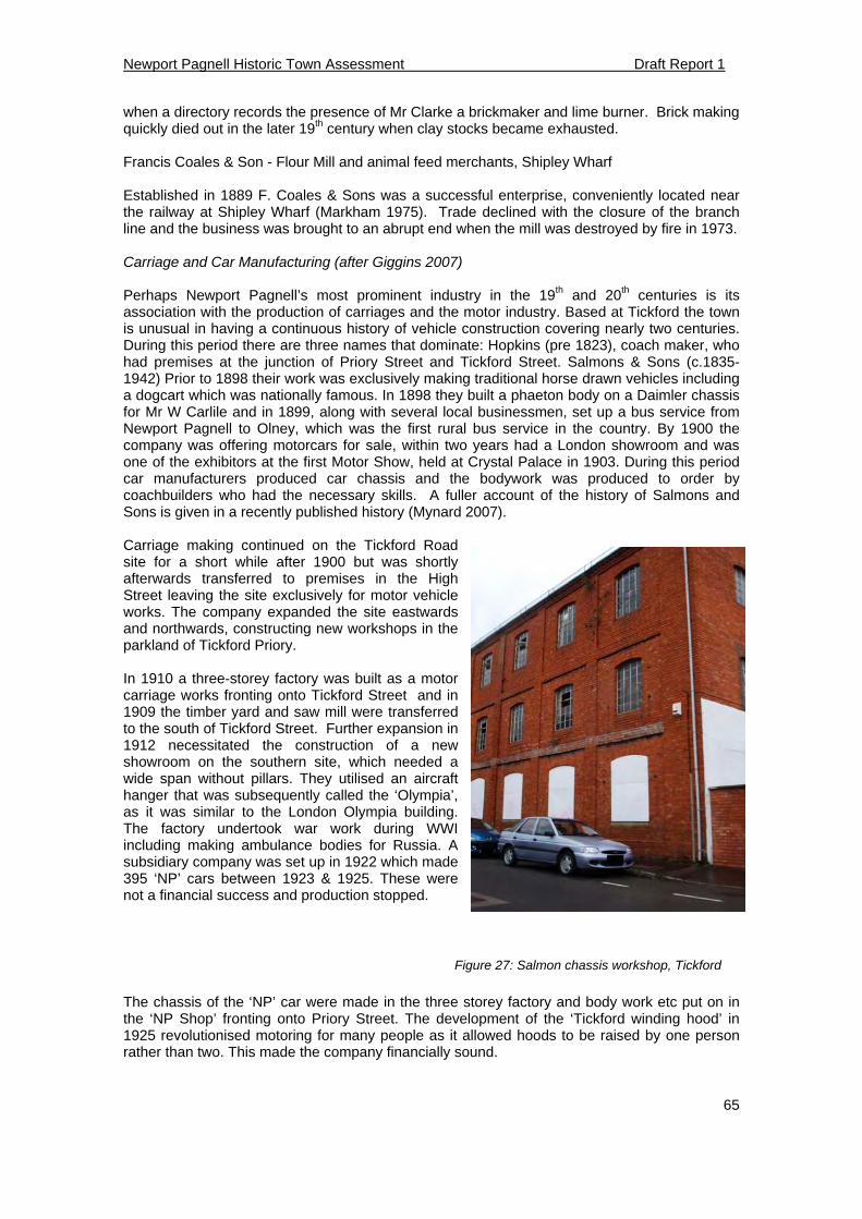
Newport Pagnell Historic Town Assessment Draft Report 1
65
when a directory records the presence of Mr Clarke a brickmaker and lime burner. Brick making quickly died out in the later 19th century when clay stocks became exhausted. Francis Coales & Son - Flour Mill and animal feed merchants, Shipley Wharf Established in 1889 F. Coales & Sons was a successful enterprise, conveniently located near the railway at Shipley Wharf (Markham 1975). Trade declined with the closure of the branch line and the business was brought to an abrupt end when the mill was destroyed by fire in 1973. Carriage and Car Manufacturing (after Giggins 2007) Perhaps Newport Pagnell’s most prominent industry in the 19th and 20th centuries is its association with the production of carriages and the motor industry. Based at Tickford the town is unusual in having a continuous history of vehicle construction covering nearly two centuries. During this period there are three names that dominate: Hopkins (pre 1823), coach maker, who had premises at the junction of Priory Street and Tickford Street. Salmons & Sons (c.1835-1942) Prior to 1898 their work was exclusively making traditional horse drawn vehicles including a dogcart which was nationally famous. In 1898 they built a phaeton body on a Daimler chassis for Mr W Carlile and in 1899, along with several local businessmen, set up a bus service from Newport Pagnell to Olney, which was the first rural bus service in the country. By 1900 the company was offering motorcars for sale, within two years had a London showroom and was one of the exhibitors at the first Motor Show, held at Crystal Palace in 1903. During this period car manufacturers produced car chassis and the bodywork was produced to order by coachbuilders who had the necessary skills. A fuller account of the history of Salmons and Sons is given in a recently published history (Mynard 2007). Carriage making continued on the Tickford Road site for a short while after 1900 but was shortly afterwards transferred to premises in the High Street leaving the site exclusively for motor vehicle works. The company expanded the site eastwards and northwards, constructing new workshops in the parkland of Tickford Priory.
In 1910 a three-storey factory was built as a motor carriage works fronting onto Tickford Street and in 1909 the timber yard and saw mill were transferred to the south of Tickford Street. Further expansion in 1912 necessitated the construction of a new showroom on the southern site, which needed a wide span without pillars. They utilised an aircraft hanger that was subsequently called the ‘Olympia’, as it was similar to the London Olympia building. The factory undertook war work during WWI including making ambulance bodies for Russia. A subsidiary company was set up in 1922 which made 395 ‘NP’ cars between 1923 & 1925. These were not a financial success and production stopped.
Figure 27: Salmon chassis workshop, Tickford
The chassis of the ‘NP’ car were made in the three storey factory and body work etc put on in the ‘NP Shop’ fronting onto Priory Street. The development of the ‘Tickford winding hood’ in 1925 revolutionised motoring for many people as it allowed hoods to be raised by one person rather than two. This made the company financially sound.
Newport Pagnell Historic Town Assessment Draft Report 1
66
A serious fire in 1933 necessitated the rebuilding of workshops on the north side of the site and during WWII the site was used for war work making such items as fire fighting ladders, chairs, tables and camp beds. It was during this period that Salmons sold the business to Ian Boswell, who in 1943 changed the name to Tickford Ltd and sold it to David Brown, owner of Aston Martin, in 1955 Aston Martin. David Brown dedicated Tickford Ltd to producing the bodies of Aston Martin cars and no other car manufacturers. Previously companies such as Daimler, Vauxhall and Austin had used Salmons for some bodywork production. In 1986 Ford purchased a 75% stake in the firm and then later acquired the remaining shares. On 19 July 2007, the Newport Pagnell plant produced its last car. Nearly 13,000 cars had been made there since 1955. The buildings on the west side of Tickford Street remain in Aston Martin ownership as the restoration and service department many of the buildings on the east of Tickford Street have now been demolished although Sunnyside, the 2 storey office building and the 3 storey factory building (fig 27, above) remain. The site is currently up for redevelopment.
Farm and Tractor works
The tractor and farm machinery repair works of WJ Cooper was based on the site of the Newport Pagnell brewery on High Street. Established in 1924 the business originally began as manufacturer of poultry sheds and farm appliances but soon branched into the maintenance of tractors and farm equipment. The old brewery was eventually modified to accommodate machinery while the front of the building facing the High Street was developed into a showroom. By the 1991 the business closed and the site was eventually demolished replaced by office and shop development which eventually became the Newport Pagnell medical centre.
Bridges
Historically the bridges of Newport Pagnell are a fundamental part of its character; depending upon its bridges to provide access to and from the town. The bridges spanning the Ouse (North and middle bridges) and Lovat (Tickford Bridge) have been rebuilt many times in the town’s history, although the funds for their repair were limited to the income from the charitable bequests managed by the bridge trustees. However, by the 19th century the increase in traffic took its toll on the bridges with wear and tear; this eventually led to an accident upon the north bridge when a stage coach ended up in the river Ouse. This incident prompted the passing of an Act of Parliament to enable the rebuilding of both of Newport’s bridges. The north bridge built of ashlar stone is a single arch spanning the main channel of the Ouse, while a second bridge of three arches crosses a secondary channel. After flood prevention works in the 1970, the three arch or middle bridge crosses the main flow of water.
Tickford Bridge (Figure 28) was constructed in 1810 by Messrs. Walker of Rotherham it is believed to be the fourth oldest cast iron bridge in Britain (Mynard & Hunt). Sections of the bridge were transported by ship to London. A tollhouse survives but the porch, which extended into the roadway has been removed. Pressure of traffic in the 1960s led the county council to consider replacing Tickford bridge but the construction of the Newport Pagnell bypass in 1979 alleviated much of the traffic from the town. It has the accolade of being the oldest iron bridge in daily use by motor traffic and its historic importance is reflected in its designation as a Scheduled Ancient Monument. (Mynard & Hunt 1995).
A full account of the history of Newport’s bridges was recently published to mark the bicentenary of the Tickford iron bridge (Mynard et al 2009).
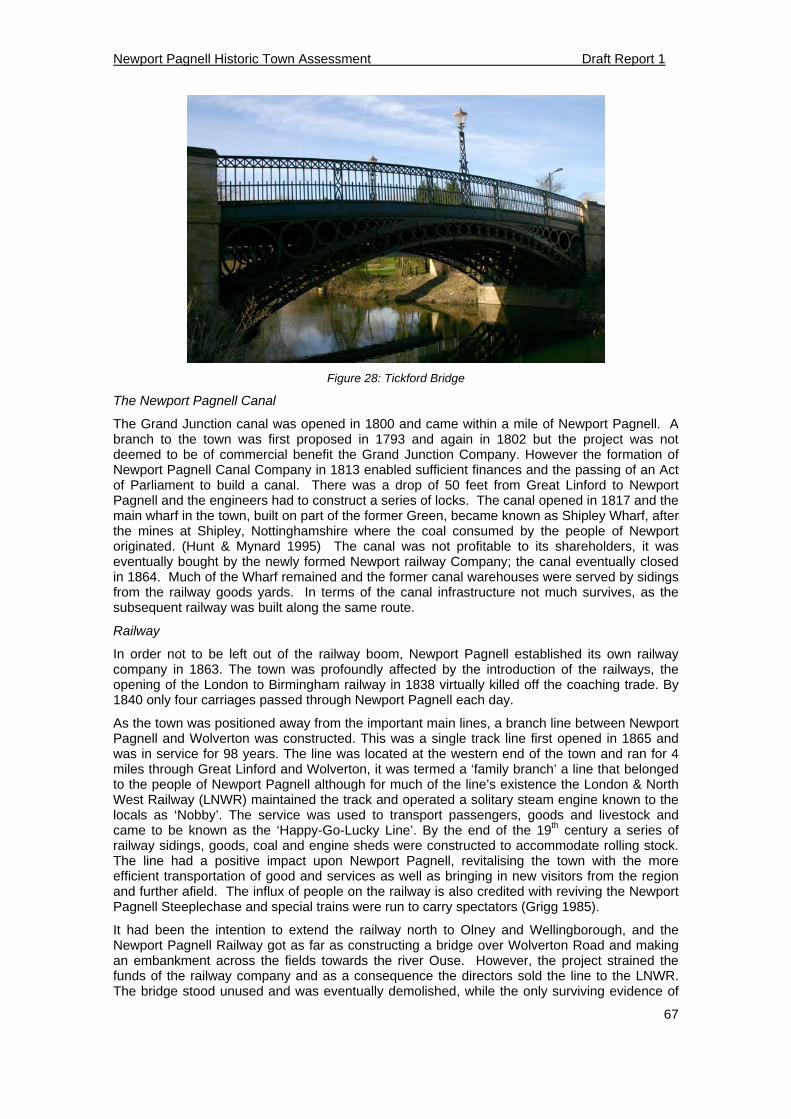
Newport Pagnell Historic Town Assessment Draft Report 1
67
Figure 28: Tickford Bridge
The Newport Pagnell Canal
The Grand Junction canal was opened in 1800 and came within a mile of Newport Pagnell. A branch to the town was first proposed in 1793 and again in 1802 but the project was not deemed to be of commercial benefit the Grand Junction Company. However the formation of Newport Pagnell Canal Company in 1813 enabled sufficient finances and the passing of an Act of Parliament to build a canal. There was a drop of 50 feet from Great Linford to Newport Pagnell and the engineers had to construct a series of locks. The canal opened in 1817 and the main wharf in the town, built on part of the former Green, became known as Shipley Wharf, after the mines at Shipley, Nottinghamshire where the coal consumed by the people of Newport originated. (Hunt & Mynard 1995) The canal was not profitable to its shareholders, it was eventually bought by the newly formed Newport railway Company; the canal eventually closed in 1864. Much of the Wharf remained and the former canal warehouses were served by sidings from the railway goods yards. In terms of the canal infrastructure not much survives, as the subsequent railway was built along the same route.
Railway
In order not to be left out of the railway boom, Newport Pagnell established its own railway company in 1863. The town was profoundly affected by the introduction of the railways, the opening of the London to Birmingham railway in 1838 virtually killed off the coaching trade. By 1840 only four carriages passed through Newport Pagnell each day.
As the town was positioned away from the important main lines, a branch line between Newport Pagnell and Wolverton was constructed. This was a single track line first opened in 1865 and was in service for 98 years. The line was located at the western end of the town and ran for 4 miles through Great Linford and Wolverton, it was termed a ‘family branch’ a line that belonged to the people of Newport Pagnell although for much of the line’s existence the London & North West Railway (LNWR) maintained the track and operated a solitary steam engine known to the locals as ‘Nobby’. The service was used to transport passengers, goods and livestock and came to be known as the ‘Happy-Go-Lucky Line’. By the end of the 19th century a series of railway sidings, goods, coal and engine sheds were constructed to accommodate rolling stock. The line had a positive impact upon Newport Pagnell, revitalising the town with the more efficient transportation of good and services as well as bringing in new visitors from the region and further afield. The influx of people on the railway is also credited with reviving the Newport Pagnell Steeplechase and special trains were run to carry spectators (Grigg 1985).
It had been the intention to extend the railway north to Olney and Wellingborough, and the Newport Pagnell Railway got as far as constructing a bridge over Wolverton Road and making an embankment across the fields towards the river Ouse. However, the project strained the funds of the railway company and as a consequence the directors sold the line to the LNWR. The bridge stood unused and was eventually demolished, while the only surviving evidence of
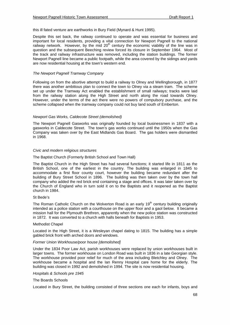
Newport Pagnell Historic Town Assessment Draft Report 1
68
this ill fated venture are earthworks in Bury Field (Mynard & Hunt 1995).
Despite this set back, the railway continued to operate and was essential for business and important for local residents, providing a vital connection for Newport Pagnell to the national railway network. However, by the mid 20th century the economic viability of the line was in question and the subsequent Beeching review forced its closure in September 1964. Most of the track and railway infrastructure was removed, including the station buildings. The former Newport Pagnell line became a public footpath, while the area covered by the sidings and yards are now residential housing at the town’s western end.
The Newport Pagnell Tramway Company Following on from the abortive attempt to build a railway to Olney and Wellingborough, in 1877 there was another ambitious plan to connect the town to Olney via a steam tram. The scheme set up under the Tramway Act enabled the establishment of small railways; tracks were laid from the railway station along the High Street and north along the road towards Olney. However, under the terms of the act there were no powers of compulsory purchase, and the scheme collapsed when the tramway company could not buy land south of Emberton.
Newport Gas Works, Caldecote Street (demolished)
The Newport Pagnell Gasworks was originally founded by local businessmen in 1837 with a gasworks in Caldecote Street. The town’s gas works continued until the 1950s when the Gas Company was taken over by the East Midlands Gas Board. The gas holders were dismantled in 1968.
Civic and modern religious structures
The Baptist Church (Formerly British School and Town Hall)
The Baptist Church in the High Street has had several functions; it started life in 1811 as the British School, one of the earliest in the country. The building was enlarged in 1845 to accommodate a first floor county court, however the building became redundant after the building of Bury Street School in 1896. The building was then taken over by the town hall company who added the red brick end containing a stage and offices. It was later taken over by the Church of England who in turn sold it on to the Baptists and it reopened as the Baptist church in 1984.
St Bede’s
The Roman Catholic Church on the Wolverton Road is an early 19th century building originally intended as a police station with a courthouse on the upper floor and a gaol below. It became a mission hall for the Plymouth Brethren, apparently when the new police station was constructed in 1872. It was converted to a church with halls beneath for Baptists in 1953.
Methodist Chapel
Located in the High Street, it is a Wesleyan chapel dating to 1815. The building has a simple gabled brick front with arched doors and windows.
Former Union Workhouse/poor house [demolished]
Under the 1834 Poor Law Act, parish workhouses were replaced by union workhouses built in larger towns. The former workhouse on London Road was built in 1836 in a late Georgian style. The workhouse provided poor relief for much of the area including Bletchley and Olney. The workhouse became a hospital and the Ian Renny Hospital care home for the elderly. The building was closed in 1992 and demolished in 1994. The site is now residential housing.
Hospitals & Schools pre 1945
The Boards Schools
Located in Bury Street, the building consisted of three sections one each for infants, boys and
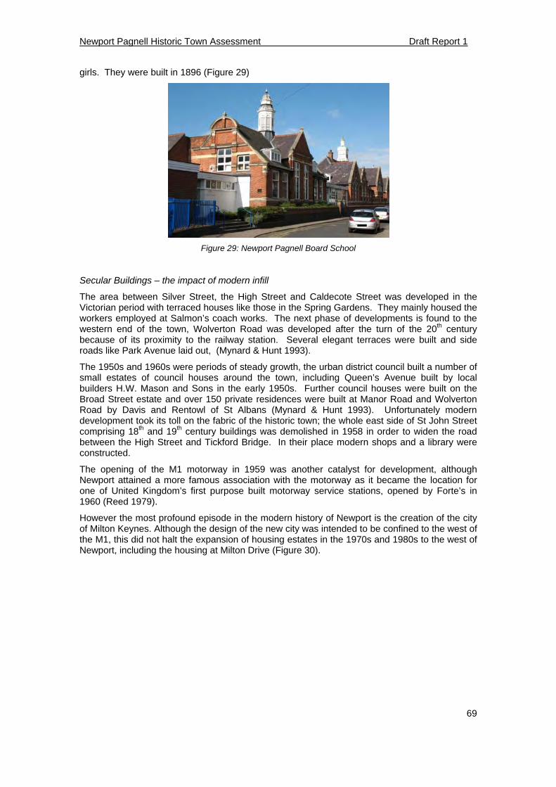
Newport Pagnell Historic Town Assessment Draft Report 1
69
girls. They were built in 1896 (Figure 29)
Figure 29: Newport Pagnell Board School
Secular Buildings – the impact of modern infill
The area between Silver Street, the High Street and Caldecote Street was developed in the Victorian period with terraced houses like those in the Spring Gardens. They mainly housed the workers employed at Salmon’s coach works. The next phase of developments is found to the western end of the town, Wolverton Road was developed after the turn of the 20th century because of its proximity to the railway station. Several elegant terraces were built and side roads like Park Avenue laid out, (Mynard & Hunt 1993).
The 1950s and 1960s were periods of steady growth, the urban district council built a number of small estates of council houses around the town, including Queen’s Avenue built by local builders H.W. Mason and Sons in the early 1950s. Further council houses were built on the Broad Street estate and over 150 private residences were built at Manor Road and Wolverton Road by Davis and Rentowl of St Albans (Mynard & Hunt 1993). Unfortunately modern development took its toll on the fabric of the historic town; the whole east side of St John Street comprising 18th and 19th century buildings was demolished in 1958 in order to widen the road between the High Street and Tickford Bridge. In their place modern shops and a library were constructed.
The opening of the M1 motorway in 1959 was another catalyst for development, although Newport attained a more famous association with the motorway as it became the location for one of United Kingdom’s first purpose built motorway service stations, opened by Forte’s in 1960 (Reed 1979).
However the most profound episode in the modern history of Newport is the creation of the city of Milton Keynes. Although the design of the new city was intended to be confined to the west of the M1, this did not halt the expansion of housing estates in the 1970s and 1980s to the west of Newport, including the housing at Milton Drive (Figure 30).
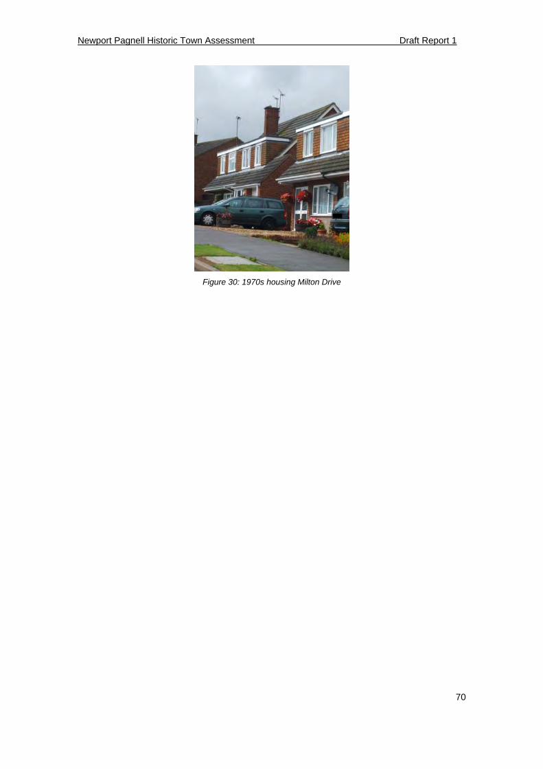
Newport Pagnell Historic Town Assessment Draft Report 1
70
Figure 30: 1970s housing Milton Drive
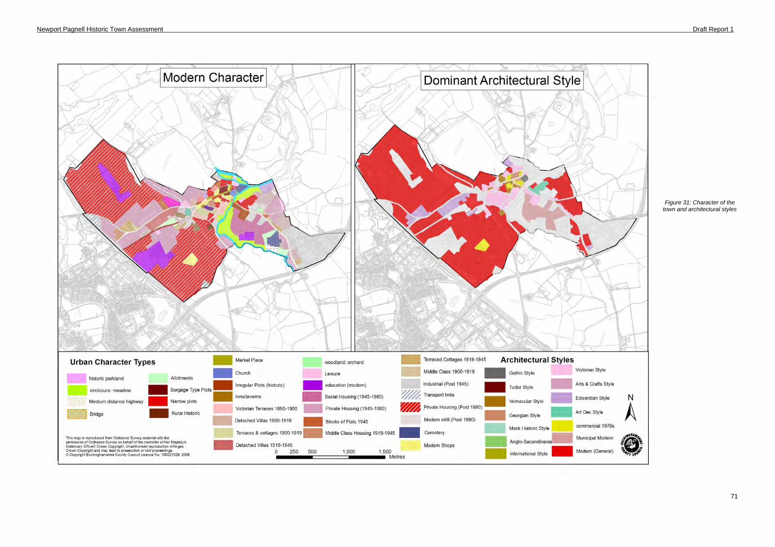
Newport Pagnell Historic Town Assessment Draft Report 1
71
Figure 31: Character of the town and architectural styles
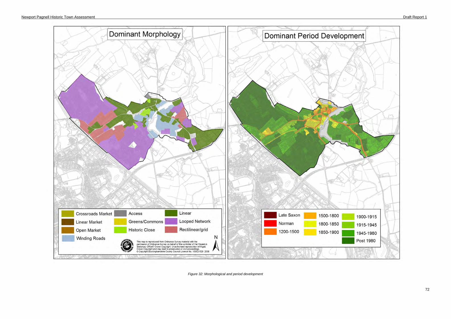
Newport Pagnell Historic Town Assessment Draft Report 1
72
Figure 32: Morphological and period development
Newport Pagnell Historic Town Assessment Draft Report
73
6 Historic Urban Zones
6.1 Introduction
The process of characterising and analysing Buckinghamshire towns produces a large quantity of information at a ‘fine-grained scale’ e.g. the character of particular buildings, town plan forms and location of archaeological data. This multitude of information can be hard to assimilate. In order to distil this information into an understandable form, the project will define larger areas or Historic Urban Zones (HUZs) for each town; these zones provide a framework for summarising information in a spatially and written form. Each zone contains several sections including:
1. A summary of the zone including reasons for the demarcation of the zone.
2. An assessment of the known and potential archaeological interest for pre 20th century areas only.
3. An assessment of existing built character.
6.2 Historic Urban Zones
The creation of these zones begins with several discrete data sets including historical cartography and documentary sources; known archaeological work; buildings evidence (whether listed or not) and the modern urban character. From this a picture can be drawn of the changes that have occurred to the built character within a given area over a given period of time. Discrete areas of the town that then show broad similarities can be grouped as one zone.
After the survey results have been mapped into GIS the resulting data is analysed to discern any larger, distinctive patterns; principally build periods, urban types, styles or other distinctive attributes of buildings. Zone boundaries are defined based around areas of homogenous townscape, although occasionally there may be more diversity as a result of piecemeal change. Other considerations for defining these zones can be made from the other attribute data, including time depth and degree of preservation.
Several different datasets will feed into the creation process for urban zones under two broad headings; historical and topographical modelling and Built character.
Historical and topographical modelling covers a variety of sources including;
Historical maps and documentary research – historical consultancy work, an analysis of historic routes and an analysis of manorial holdings where available
Archaeological and environmental evidence – data stored in the HER, geological and soils databases provided by the BGS and Cranfield University and an analysis of the distribution of pottery fabrics for the Saxon and medieval periods
The Built Character heading incorporates the following sources;
Built environment – English Heritage listed buildings and historic map research
An analysis of the modern urban form – The historic urban character database produced for this project and designations such as Conservation Areas and Registered Parks and Gardens
6.3 Archaeological Assessment
The second part of the analysis examines the significance and potential of towns from an archaeological perspective, this assessment is undertaken by the analysis of archaeological and historical sources. Unlike the built environment, the focus of investigation is limited to the historic cores of settlements, where most archaeological evidence exists and the likelihood of archaeological discovery is at its greatest. The assessment includes consideration of the archaeological interest of above-ground buildings and structures, which may contain hidden elements which are earlier than their nominal date based on visible architectural details.
The method for evaluating archaeological significance is an adaptation of English Heritage’s Monuments Protection Plan for urban areas (English Heritage 1992). For the character zones
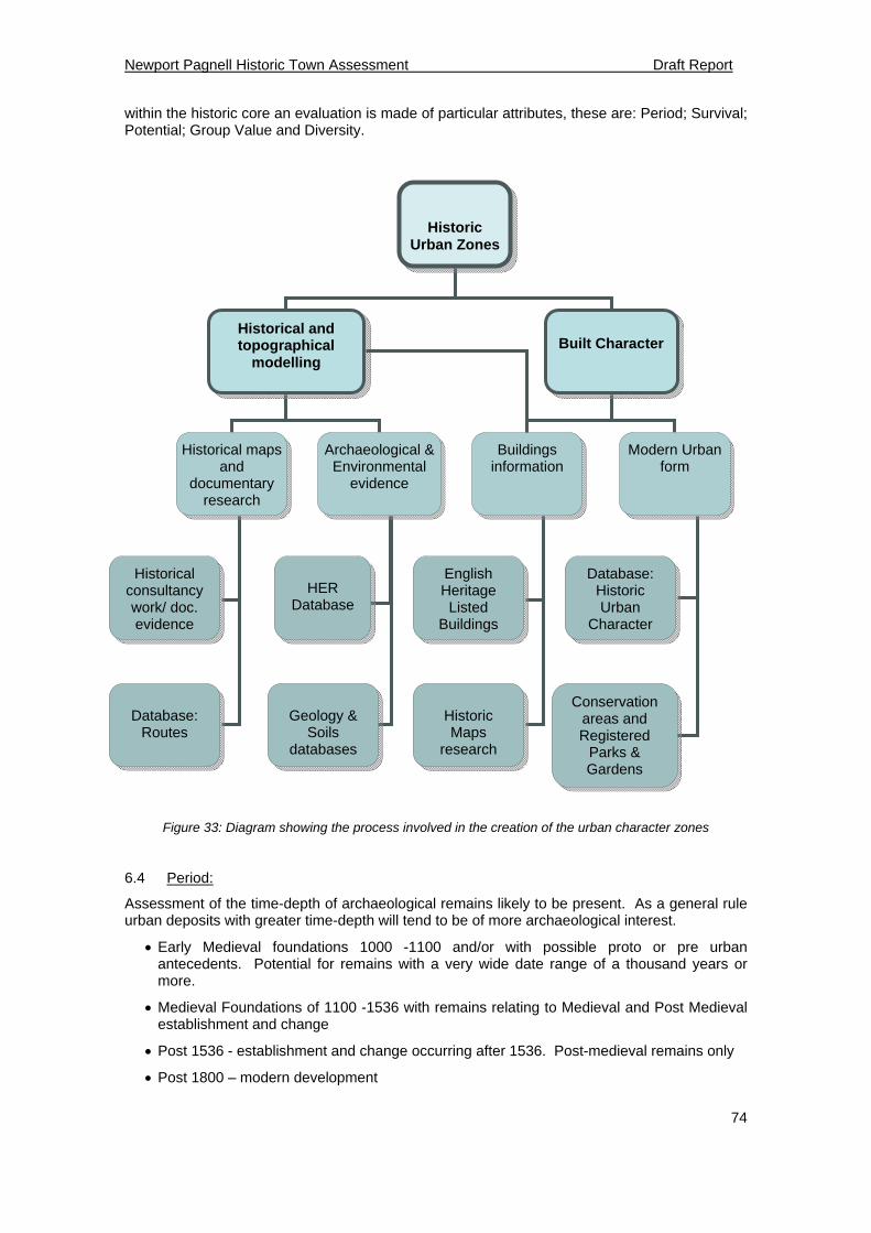
Newport Pagnell Historic Town Assessment Draft Report
74
Historic Urban Zones
Historical and topographical
modelling
Built Character
Historical maps and
documentary research
Archaeological & Environmental
evidence
Buildings information
Modern Urban form
Historical consultancy work/ doc. evidence
Database: Routes
HER Database
Geology & Soils
databases
English Heritage Listed
Buildings
Historic Maps
research
Database: Historic Urban
Character
Conservation areas and Registered
Parks & Gardens
within the historic core an evaluation is made of particular attributes, these are: Period; Survival; Potential; Group Value and Diversity.
Figure 33: Diagram showing the process involved in the creation of the urban character zones
6.4 Period:
Assessment of the time-depth of archaeological remains likely to be present. As a general rule urban deposits with greater time-depth will tend to be of more archaeological interest.
Early Medieval foundations 1000 -1100 and/or with possible proto or pre urban antecedents. Potential for remains with a very wide date range of a thousand years or more.
Medieval Foundations of 1100 -1536 with remains relating to Medieval and Post Medieval establishment and change
Post 1536 - establishment and change occurring after 1536. Post-medieval remains only
Post 1800 – modern development
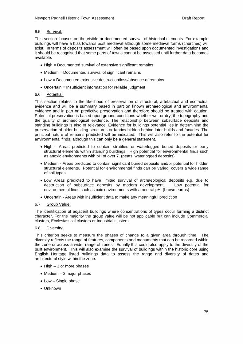
Newport Pagnell Historic Town Assessment Draft Report
75
6.5 Survival:
This section focuses on the visible or documented survival of historical elements. For example buildings will have a bias towards post medieval although some medieval forms (churches) will exist. In terms of deposits assessment will often be based upon documented investigations and it should be recognised that some parts of towns cannot be assessed until further data becomes available.
High = Documented survival of extensive significant remains
Medium = Documented survival of significant remains
Low = Documented extensive destruction/loss/absence of remains
Uncertain = Insufficient information for reliable judgment
6.6 Potential:
This section relates to the likelihood of preservation of structural, artefactual and ecofactual evidence and will be a summary based in part on known archaeological and environmental evidence and in part on predictive preservation and therefore should be treated with caution. Potential preservation is based upon ground conditions whether wet or dry, the topography and the quality of archaeological evidence. The relationship between subsurface deposits and standing buildings is also of relevance. Evidence for buildings potential lies in determining the preservation of older building structures or fabrics hidden behind later builds and facades. The principal nature of remains predicted will be indicated. This will also refer to the potential for environmental finds, although this can only be a general statement.
High - Areas predicted to contain stratified or waterlogged buried deposits or early structural elements within standing buildings. High potential for environmental finds such as anoxic environments with pH of over 7. (peats, waterlogged deposits)
Medium - Areas predicted to contain significant buried deposits and/or potential for hidden structural elements. Potential for environmental finds can be varied, covers a wide range of soil types.
Low Areas predicted to have limited survival of archaeological deposits e.g. due to destruction of subsurface deposits by modern development. Low potential for environmental finds such as oxic environments with a neutral pH. (brown earths)
Uncertain - Areas with insufficient data to make any meaningful prediction
6.7 Group Value:
The identification of adjacent buildings where concentrations of types occur forming a distinct character. For the majority the group value will be not applicable but can include Commercial clusters, Ecclesiastical clusters or Industrial clusters.
6.8 Diversity:
This criterion seeks to measure the phases of change to a given area through time. The diversity reflects the range of features, components and monuments that can be recorded within the zone or across a wider range of zones. Equally this could also apply to the diversity of the built environment. This will also examine the survival of buildings within the historic core using English Heritage listed buildings data to assess the range and diversity of dates and architectural style within the zone.
High – 3 or more phases
Medium – 2 major phases
Low – Single phase
Unknown

Newport Pagnell Historic Town Assessment Draft Report 1
76
Figure 34: Historic Character Zones for Newport Pagnell
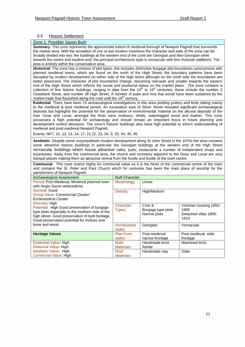
Newport Pagnell Historic Town Assessment Draft Report 1
77
6.9 Historic Settlement
Zone 1: Possible Saxon Burh Summary: This zone represents the approximate extent of medieval borough of Newport Pagnell that surrounds the market area. With the exception of one or two modern insertions the character and style of the zone can be broadly divided into two: the buildings at the western end of the zone are Georgian and Neo-Georgian while towards the centre and eastern end, the principal architectural style is vernacular with few Victorian additions. The area is entirely within the conservation area. Historical: The zone has a mixture of plot types; this includes distinctive burgage plot boundaries synonymous with planned medieval towns, which are found on the north of the High Street, the boundary patterns have been disrupted by modern development on either side of the high street although on the north side the boundaries are better preserved. The character of plot boundaries change, becoming narrower and smaller towards the eastern end of the High Street which reflects the social and positional status on the market place. The zone contains a collection of fine historic buildings, ranging in date from the 14th to 19th centuries; these include the number 2 Ousebank Street, and number 38 High Street. A number of pubs and inns that would have been sustained by the market trade that flourished along the road until the 19th century. Evidential: There have been 15 archaeological investigations in this area yielding pottery and finds dating mainly to the medieval & post medieval period. An excavation east of Silver Street revealed significant archaeological deposits but highlights the potential for the preservation of environmental material on the alluvial deposits of the river Ouse and Lovat; amongst the finds were molluscs, shells, waterlogged wood and leather. This zone possesses a high potential for archaeology and should remain an important focus in future planning and development control decisions. The zone’s historic buildings also have high potential to inform understanding of medieval and post-medieval Newport Pagnell.
Events: NP7, 10, 12, 13, 14, 17, 21 22, 23, 24, 3, 33, 34, 35, 45,
Aesthetic: Despite some unsympathetic modern development along St John Street in the 1970s the area contains some attractive historic buildings in particular the Georgian buildings at the western end of the High Street vernacular buildings which house attractive cafes, pubs, restaurants a number of independent shops and businesses. Away from the commercial area, the church and cemetery adjacent to the Ouse and Lovat are very tranquil places making them an attractive retreat from the hustle and bustle of the town centre. Communal: This zone scores highly for communal value as it is the heart of the commercial centre of the town and contains the St. Peter and Paul Church which for centuries has been the main place of worship for the parishioners of Newport Pagnell. Archaeological Assessment Built Character
Morphology: Linear
Density: High/Medium
Character Types:
Civic & Burgage type plots Narrow plots
Victorian housing 1850-1900 Detached villas 1900-1919
Period: Post Medieval, Medieval planned town with Anglo Saxon antecedents Survival: Good Group Value: Commercial Cluster/ Ecclesiastical Cluster Diversity: High Potential: High Good preservation of burgage type plots especially to the northern side of the high street. Good preservation of built heritage. Good preservation potential for mollusc and bone and wood. Architectural
styles: Georgian
Vernacular
Heritage Values Plan Form styles:
Post medieval narrow frontage
Post medieval wide frontage
Build Materials:
Handmade brick Ashlar
Machined brick Evidential Value: High Historical Value: High Aesthetic Value: High Communal Value: High
Roof Materials:
Handmade clay Slate
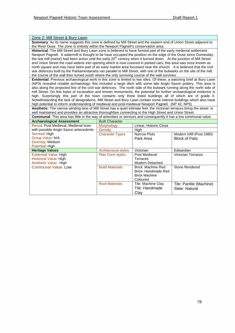
Newport Pagnell Historic Town Assessment Draft Report 1
78
Zone 2: Mill Street & Bury Lawn Summary: As its name suggests this zone is defined by Mill Street and the eastern end of Union Street adjacent to the River Ouse. The zone is entirely within the Newport Pagnell’s conservation area. Historical: The Mill Street and Bury Lawn zone is believed to have formed part of the early medieval settlement Newport Pagnell. A watermill is thought to be have occupied the position on the edge of the Ouse since Domesday, the last mill (name) had been active until the early 20th century when it burned down. At the junction of Mill Street and Union Street the road widens into opening which is now covered in parked cars, this area was once known as north square and may have been part of an early market area focussed near the church. It is believed that the civil war defences built by the Parliamentarians ran parallel to Mill Street, with one of the bulwarks on the site of the mill, the course of the wall then turned south where the only surviving course of the wall survives. Evidential: Previous archaeological work in this zone is limited to two sites. Of these, a watching brief at Bury Lawn (NP3) revealed notable archaeology; this included a large ditch with some late Anglo Saxon pottery. This area is also along the projected line of the civil war defences. The north side of the bulwark running along the north side of mill Street. On this basis of excavation and known monuments, the potential for further archaeological evidence is high. Surprisingly this part of the town contains only three listed buildings all of which are of grade II. Notwithstanding the lack of designations, Mill Street and Bury Lawn contain some interest buildings which also have high potential to inform understanding of medieval and post-medieval Newport Pagnell. (NP 42, NP5) Aesthetic: The narrow winding lane of Mill Street has a quiet intimate feel, the Victorian terraces lining the street is well maintained and provides an attractive thoroughfare connecting to the High Street and Union Street. Communal: This area has little in the way of amenities or services and consequently it has a low communal value. Archaeological Assessment Built Character
Morphology: Linear, Historic Close Density: High
Period: Post Medieval, Medieval town with possible Anglo Saxon antecedents Survival: High Group Value: N/A Diversity: Medium Potential: High
Character Types: Narrow Plots Park Area
Modern Infill (Post 1980) Block of Flats
Heritage Values Architectural styles: Victorian Edwardian Plan Form styles: Post Medieval
Terraces Modern Detached
Victorian Terraces
Build Materials: Brick: Machine Red Brick: Handmade Red Brick Machine Coloured
Stone Rendered
Evidential Value: High Historical Value: High Aesthetic Value: High Communal Value: Low
Roof Materials: Tile: Machine Clay Tile: Handmade Clay
Tile: Pantile (Machine) Slate: Natural
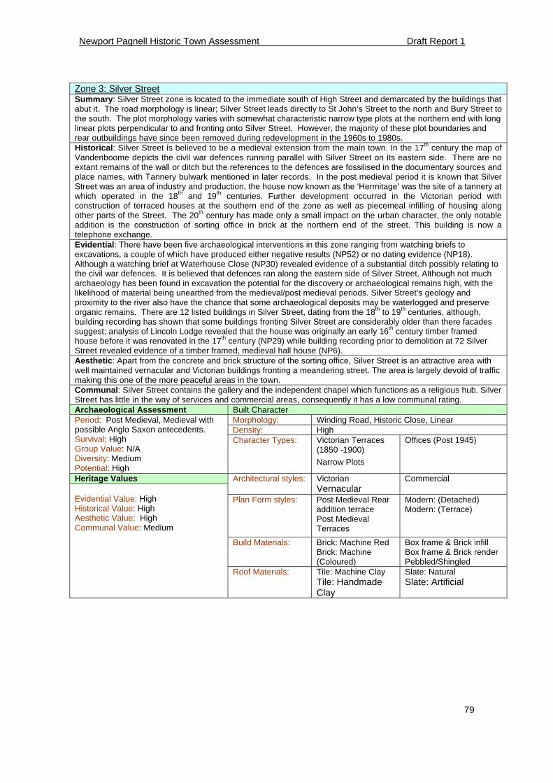
Newport Pagnell Historic Town Assessment Draft Report 1
79
Zone 3: Silver Street Summary: Silver Street zone is located to the immediate south of High Street and demarcated by the buildings that abut it. The road morphology is linear; Silver Street leads directly to St John’s Street to the north and Bury Street to the south. The plot morphology varies with somewhat characteristic narrow type plots at the northern end with long linear plots perpendicular to and fronting onto Silver Street. However, the majority of these plot boundaries and rear outbuildings have since been removed during redevelopment in the 1960s to 1980s. Historical: Silver Street is believed to be a medieval extension from the main town. In the 17th century the map of Vandenboome depicts the civil war defences running parallel with Silver Street on its eastern side. There are no extant remains of the wall or ditch but the references to the defences are fossilised in the documentary sources and place names, with Tannery bulwark mentioned in later records. In the post medieval period it is known that Silver Street was an area of industry and production, the house now known as the ‘Hermitage’ was the site of a tannery at which operated in the 18th and 19th centuries. Further development occurred in the Victorian period with construction of terraced houses at the southern end of the zone as well as piecemeal infilling of housing along other parts of the Street. The 20th century has made only a small impact on the urban character, the only notable addition is the construction of sorting office in brick at the northern end of the street. This building is now a telephone exchange. Evidential: There have been five archaeological interventions in this zone ranging from watching briefs to excavations, a couple of which have produced either negative results (NP52) or no dating evidence (NP18). Although a watching brief at Waterhouse Close (NP30) revealed evidence of a substantial ditch possibly relating to the civil war defences. It is believed that defences ran along the eastern side of Silver Street. Although not much archaeology has been found in excavation the potential for the discovery or archaeological remains high, with the likelihood of material being unearthed from the medieval/post medieval periods. Silver Street’s geology and proximity to the river also have the chance that some archaeological deposits may be waterlogged and preserve organic remains. There are 12 listed buildings in Silver Street, dating from the 18th to 19th centuries, although, building recording has shown that some buildings fronting Silver Street are considerably older than there facades suggest; analysis of Lincoln Lodge revealed that the house was originally an early 16th century timber framed house before it was renovated in the 17th century (NP29) while building recording prior to demolition at 72 Silver Street revealed evidence of a timber framed, medieval hall house (NP6). Aesthetic: Apart from the concrete and brick structure of the sorting office, Silver Street is an attractive area with well maintained vernacular and Victorian buildings fronting a meandering street. The area is largely devoid of traffic making this one of the more peaceful areas in the town. Communal: Silver Street contains the gallery and the independent chapel which functions as a religious hub. Silver Street has little in the way of services and commercial areas, consequently it has a low communal rating. Archaeological Assessment Built Character
Morphology: Winding Road, Historic Close, Linear Density: High
Period: Post Medieval, Medieval with possible Anglo Saxon antecedents. Survival: High Group Value: N/A Diversity: Medium Potential: High
Character Types: Victorian Terraces (1850 -1900)
Narrow Plots
Offices (Post 1945)
Heritage Values Architectural styles: Victorian Vernacular
Commercial
Plan Form styles: Post Medieval Rear addition terrace Post Medieval Terraces
Modern: (Detached) Modern: (Terrace)
Build Materials: Brick: Machine Red Brick: Machine (Coloured)
Box frame & Brick infill Box frame & Brick render Pebbled/Shingled
Evidential Value: High Historical Value: High Aesthetic Value: High Communal Value: Medium
Roof Materials: Tile: Machine Clay Tile: Handmade Clay
Slate: Natural Slate: Artificial
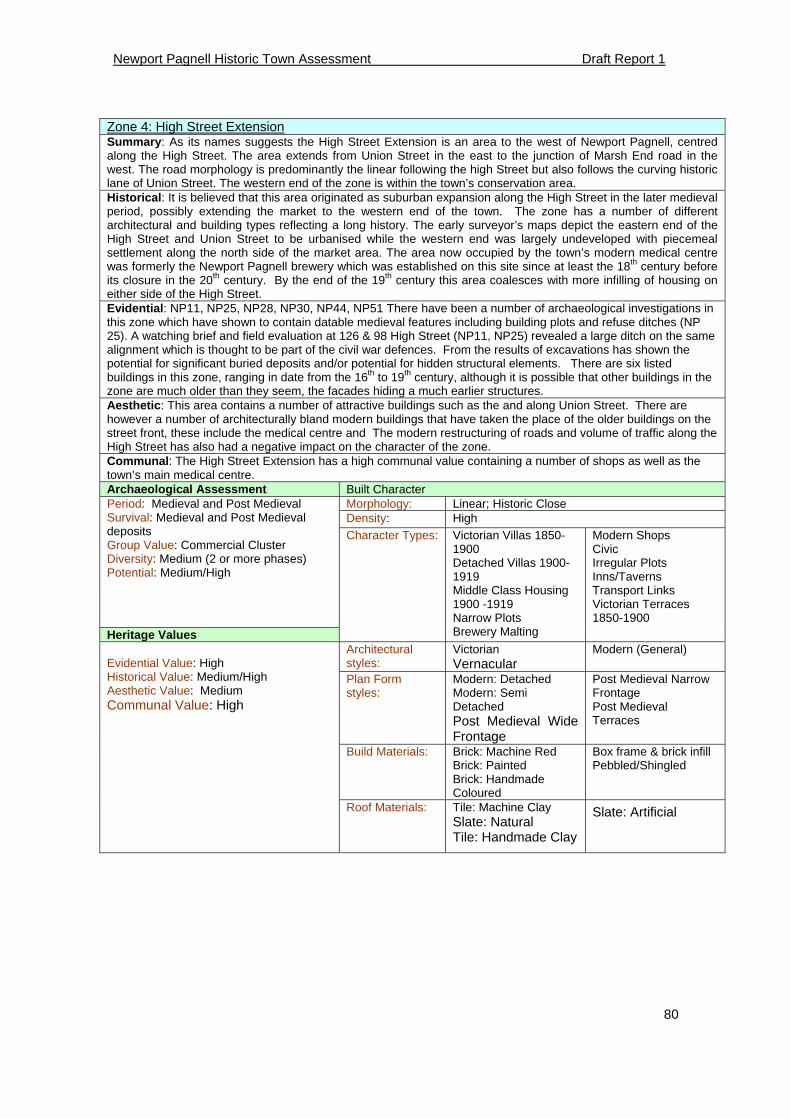
Newport Pagnell Historic Town Assessment Draft Report 1
80
Zone 4: High Street Extension Summary: As its names suggests the High Street Extension is an area to the west of Newport Pagnell, centred along the High Street. The area extends from Union Street in the east to the junction of Marsh End road in the west. The road morphology is predominantly the linear following the high Street but also follows the curving historic lane of Union Street. The western end of the zone is within the town’s conservation area. Historical: It is believed that this area originated as suburban expansion along the High Street in the later medieval period, possibly extending the market to the western end of the town. The zone has a number of different architectural and building types reflecting a long history. The early surveyor’s maps depict the eastern end of the High Street and Union Street to be urbanised while the western end was largely undeveloped with piecemeal settlement along the north side of the market area. The area now occupied by the town’s modern medical centre was formerly the Newport Pagnell brewery which was established on this site since at least the 18th century before its closure in the 20th century. By the end of the 19th century this area coalesces with more infilling of housing on either side of the High Street. Evidential: NP11, NP25, NP28, NP30, NP44, NP51 There have been a number of archaeological investigations in this zone which have shown to contain datable medieval features including building plots and refuse ditches (NP 25). A watching brief and field evaluation at 126 & 98 High Street (NP11, NP25) revealed a large ditch on the same alignment which is thought to be part of the civil war defences. From the results of excavations has shown the potential for significant buried deposits and/or potential for hidden structural elements. There are six listed buildings in this zone, ranging in date from the 16th to 19th century, although it is possible that other buildings in the zone are much older than they seem, the facades hiding a much earlier structures. Aesthetic: This area contains a number of attractive buildings such as the and along Union Street. There are however a number of architecturally bland modern buildings that have taken the place of the older buildings on the street front, these include the medical centre and The modern restructuring of roads and volume of traffic along the High Street has also had a negative impact on the character of the zone. Communal: The High Street Extension has a high communal value containing a number of shops as well as the town’s main medical centre. Archaeological Assessment Built Character
Morphology: Linear; Historic Close Density: High
Period: Medieval and Post Medieval Survival: Medieval and Post Medieval deposits Group Value: Commercial Cluster Diversity: Medium (2 or more phases) Potential: Medium/High
Heritage Values
Character Types: Victorian Villas 1850-1900 Detached Villas 1900-1919 Middle Class Housing 1900 -1919 Narrow Plots Brewery Malting
Modern Shops Civic Irregular Plots Inns/Taverns Transport Links Victorian Terraces 1850-1900
Architectural styles:
Victorian Vernacular
Modern (General)
Plan Form styles:
Modern: Detached Modern: Semi Detached Post Medieval Wide Frontage
Post Medieval Narrow Frontage Post Medieval Terraces
Build Materials: Brick: Machine Red Brick: Painted Brick: Handmade Coloured
Box frame & brick infill Pebbled/Shingled
Evidential Value: High Historical Value: Medium/High Aesthetic Value: Medium Communal Value: High
Roof Materials: Tile: Machine Clay Slate: Natural Tile: Handmade Clay
Slate: Artificial
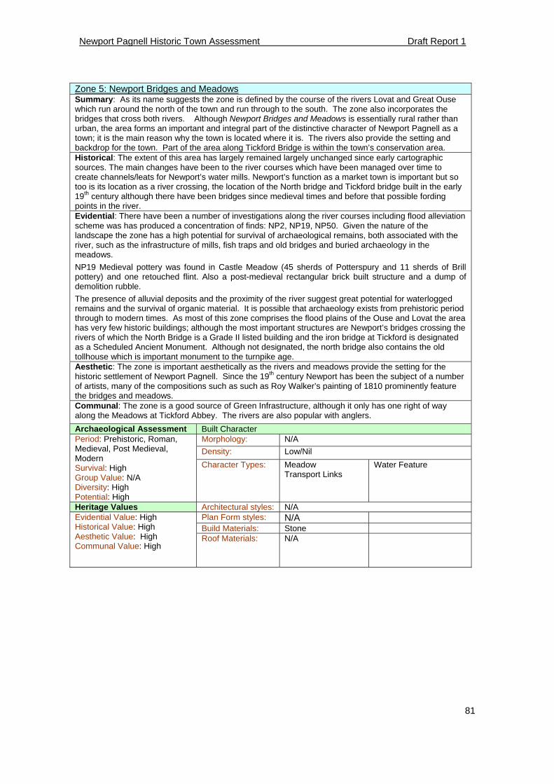
Newport Pagnell Historic Town Assessment Draft Report 1
81
Zone 5: Newport Bridges and Meadows Summary: As its name suggests the zone is defined by the course of the rivers Lovat and Great Ouse which run around the north of the town and run through to the south. The zone also incorporates the bridges that cross both rivers. Although Newport Bridges and Meadows is essentially rural rather than urban, the area forms an important and integral part of the distinctive character of Newport Pagnell as a town; it is the main reason why the town is located where it is. The rivers also provide the setting and backdrop for the town. Part of the area along Tickford Bridge is within the town’s conservation area. Historical: The extent of this area has largely remained largely unchanged since early cartographic sources. The main changes have been to the river courses which have been managed over time to create channels/leats for Newport’s water mills. Newport’s function as a market town is important but so too is its location as a river crossing, the location of the North bridge and Tickford bridge built in the early 19th century although there have been bridges since medieval times and before that possible fording points in the river. Evidential: There have been a number of investigations along the river courses including flood alleviation scheme was has produced a concentration of finds: NP2, NP19, NP50. Given the nature of the landscape the zone has a high potential for survival of archaeological remains, both associated with the river, such as the infrastructure of mills, fish traps and old bridges and buried archaeology in the meadows.
NP19 Medieval pottery was found in Castle Meadow (45 sherds of Potterspury and 11 sherds of Brill pottery) and one retouched flint. Also a post-medieval rectangular brick built structure and a dump of demolition rubble.
The presence of alluvial deposits and the proximity of the river suggest great potential for waterlogged remains and the survival of organic material. It is possible that archaeology exists from prehistoric period through to modern times. As most of this zone comprises the flood plains of the Ouse and Lovat the area has very few historic buildings; although the most important structures are Newport’s bridges crossing the rivers of which the North Bridge is a Grade II listed building and the iron bridge at Tickford is designated as a Scheduled Ancient Monument. Although not designated, the north bridge also contains the old tollhouse which is important monument to the turnpike age. Aesthetic: The zone is important aesthetically as the rivers and meadows provide the setting for the historic settlement of Newport Pagnell. Since the 19th century Newport has been the subject of a number of artists, many of the compositions such as such as Roy Walker’s painting of 1810 prominently feature the bridges and meadows. Communal: The zone is a good source of Green Infrastructure, although it only has one right of way along the Meadows at Tickford Abbey. The rivers are also popular with anglers.
Archaeological Assessment Built Character Morphology: N/A
Density: Low/Nil
Period: Prehistoric, Roman, Medieval, Post Medieval, Modern Survival: High Group Value: N/A Diversity: High Potential: High
Character Types: Meadow Transport Links
Water Feature
Heritage Values Architectural styles: N/A Plan Form styles: N/A Build Materials: Stone
Evidential Value: High Historical Value: High Aesthetic Value: High Communal Value: High
Roof Materials: N/A
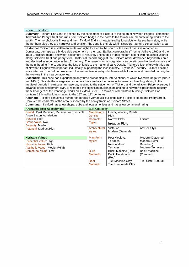
Newport Pagnell Historic Town Assessment Draft Report 1
82
Zone 6: Tickford Summary: Tickford End zone is defined by the settlement of Tickford to the south of Newport Pagnell, comprises Tickford and Priory Street and runs from Tickford bridge in the north to the former car manufacturing works to the south. The morphology is linear and the. Tickford End is characterised by long plots on its southern side, while the northern side they are narrower and smaller. The zone is entirely within Newport Pagnell’s conservation area.
Historical: Tickford is a settlement in its own right, located to the south of the river Lovat it is recorded in Domesday, perhaps as a bridge side settlement on the road. Earliest cartography (Thomas Jeffreys 1760 and the 1808 Enclosure maps) show that settlement is relatively unchanged from it modern extent with housing clustered along Tickford Street and priory street. Historical records suggest that Tickford never developed beyond this area and declined in importance in the 13th century. The reasons for its stagnation can be attributed to the dominance of the neighbouring Priory, and also the loss of lands to the manorial park. Despite Tickford’s lack of growth this part of Newport Pagnell was important industrially, supporting the lace industry. By the 20th century Tickford became associated with the Salmon works and the automotive industry which revived its fortunes and provided housing for the workers in the nearby factories. Evidential: This zone has experienced only three archaeological interventions, of which two were negative (NP37 and NP48). Despite these negative responses this area has the potential to reveal archaeology dating to the medieval periods in particular archaeology relating to the settlement of Tickford and the adjacent Priory. A survey in advance of redevelopment (NP16) recorded the significant buildings belonging to Newport’s parchment industry -the fellmongers at the Ironbridge works on Tickford Street. In terms of other historic buildings Tickford End contains 12 listed buildings dating to the 18th and 19th centuries. Aesthetic: Tickford contains a number of attractive vernacular buildings along Tickford Road and Priory Street. However the character of the area is spoiled by the heavy traffic on Tickford Street. Communal: Tickford has a few shops, pubs and local amenities and has a low communal rating.
Archaeological Assessment Built Character Morphology: Linear; Winding Roads Density: High Character Types:
Narrow Plots
Irregular Plots
Leisure
Period: Post Medieval, Medieval with possible Anglo Saxon foundations Survival: High Group Value: N/A Diversity: Medium Potential: Medium/High
Architectural styles:
Victorian Modern (General)
Art Dec Style
Heritage Values Plan Form styles:
Post Medieval Terraces Rear addition Terraces
Modern (Detached) Modern (Semi Detached) Modern (Terraces)
Build Materials:
Brick: Machine (Red) Brick: Handmade (Red)
Brick: Machine (Coloured)
Evidential Value: High Historical Value: High Aesthetic Value: Medium/High Communal Value: Low
Roof Materials:
Tile: Machine Clay Tile: Handmade Clay
Tile: Slate (Natural)
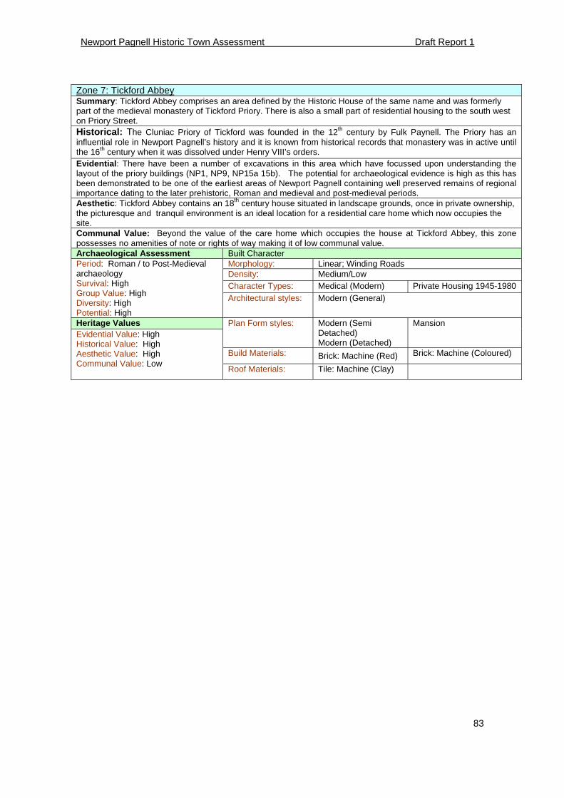
Newport Pagnell Historic Town Assessment Draft Report 1
83
Zone 7: Tickford Abbey Summary: Tickford Abbey comprises an area defined by the Historic House of the same name and was formerly part of the medieval monastery of Tickford Priory. There is also a small part of residential housing to the south west on Priory Street. Historical: The Cluniac Priory of Tickford was founded in the 12th century by Fulk Paynell. The Priory has an influential role in Newport Pagnell’s history and it is known from historical records that monastery was in active until the 16th century when it was dissolved under Henry VIII’s orders. Evidential: There have been a number of excavations in this area which have focussed upon understanding the layout of the priory buildings (NP1, NP9, NP15a 15b). The potential for archaeological evidence is high as this has been demonstrated to be one of the earliest areas of Newport Pagnell containing well preserved remains of regional importance dating to the later prehistoric, Roman and medieval and post-medieval periods. Aesthetic: Tickford Abbey contains an 18th century house situated in landscape grounds, once in private ownership, the picturesque and tranquil environment is an ideal location for a residential care home which now occupies the site. Communal Value: Beyond the value of the care home which occupies the house at Tickford Abbey, this zone possesses no amenities of note or rights of way making it of low communal value. Archaeological Assessment Built Character
Morphology: Linear; Winding Roads Density: Medium/Low Character Types: Medical (Modern) Private Housing 1945-1980
Period: Roman / to Post-Medieval archaeology Survival: High Group Value: High Diversity: High Potential: High
Architectural styles: Modern (General)
Heritage Values Plan Form styles: Modern (Semi Detached) Modern (Detached)
Mansion
Build Materials: Brick: Machine (Red) Brick: Machine (Coloured)
Evidential Value: High Historical Value: High Aesthetic Value: High Communal Value: Low
Roof Materials: Tile: Machine (Clay)
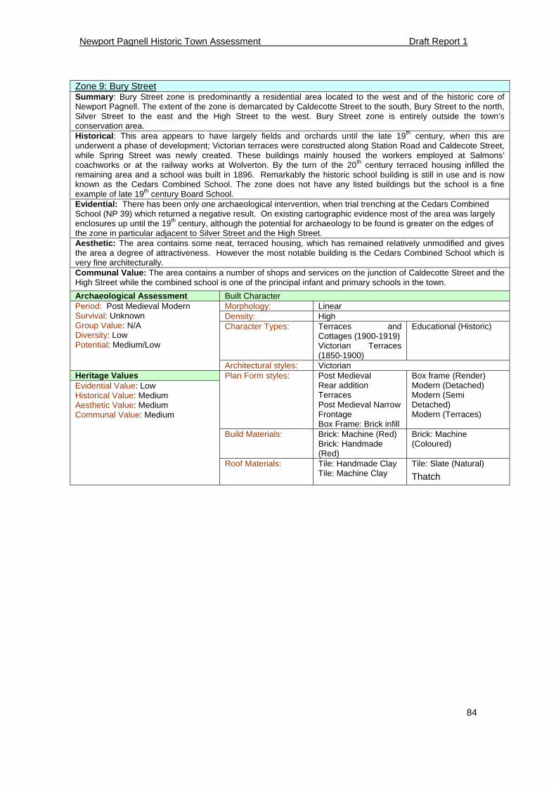
Newport Pagnell Historic Town Assessment Draft Report 1
84
Zone 9: Bury Street Summary: Bury Street zone is predominantly a residential area located to the west and of the historic core of Newport Pagnell. The extent of the zone is demarcated by Caldecotte Street to the south, Bury Street to the north, Silver Street to the east and the High Street to the west. Bury Street zone is entirely outside the town’s conservation area. Historical: This area appears to have largely fields and orchards until the late 19th century, when this are underwent a phase of development; Victorian terraces were constructed along Station Road and Caldecote Street, while Spring Street was newly created. These buildings mainly housed the workers employed at Salmons’ coachworks or at the railway works at Wolverton. By the turn of the 20th century terraced housing infilled the remaining area and a school was built in 1896. Remarkably the historic school building is still in use and is now known as the Cedars Combined School. The zone does not have any listed buildings but the school is a fine example of late 19th century Board School. Evidential: There has been only one archaeological intervention, when trial trenching at the Cedars Combined School (NP 39) which returned a negative result. On existing cartographic evidence most of the area was largely enclosures up until the 19th century, although the potential for archaeology to be found is greater on the edges of the zone in particular adjacent to Silver Street and the High Street. Aesthetic: The area contains some neat, terraced housing, which has remained relatively unmodified and gives the area a degree of attractiveness. However the most notable building is the Cedars Combined School which is very fine architecturally. Communal Value: The area contains a number of shops and services on the junction of Caldecotte Street and the High Street while the combined school is one of the principal infant and primary schools in the town.
Archaeological Assessment Built Character Morphology: Linear Density: High Character Types: Terraces and
Cottages (1900-1919) Victorian Terraces (1850-1900)
Educational (Historic)
Period: Post Medieval Modern Survival: Unknown Group Value: N/A Diversity: Low Potential: Medium/Low
Architectural styles: Victorian
Heritage Values Plan Form styles: Post Medieval Rear addition Terraces Post Medieval Narrow Frontage Box Frame: Brick infill
Box frame (Render) Modern (Detached) Modern (Semi Detached) Modern (Terraces)
Build Materials: Brick: Machine (Red) Brick: Handmade (Red)
Brick: Machine (Coloured)
Evidential Value: Low Historical Value: Medium Aesthetic Value: Medium Communal Value: Medium
Roof Materials: Tile: Handmade Clay Tile: Machine Clay
Tile: Slate (Natural)
Thatch
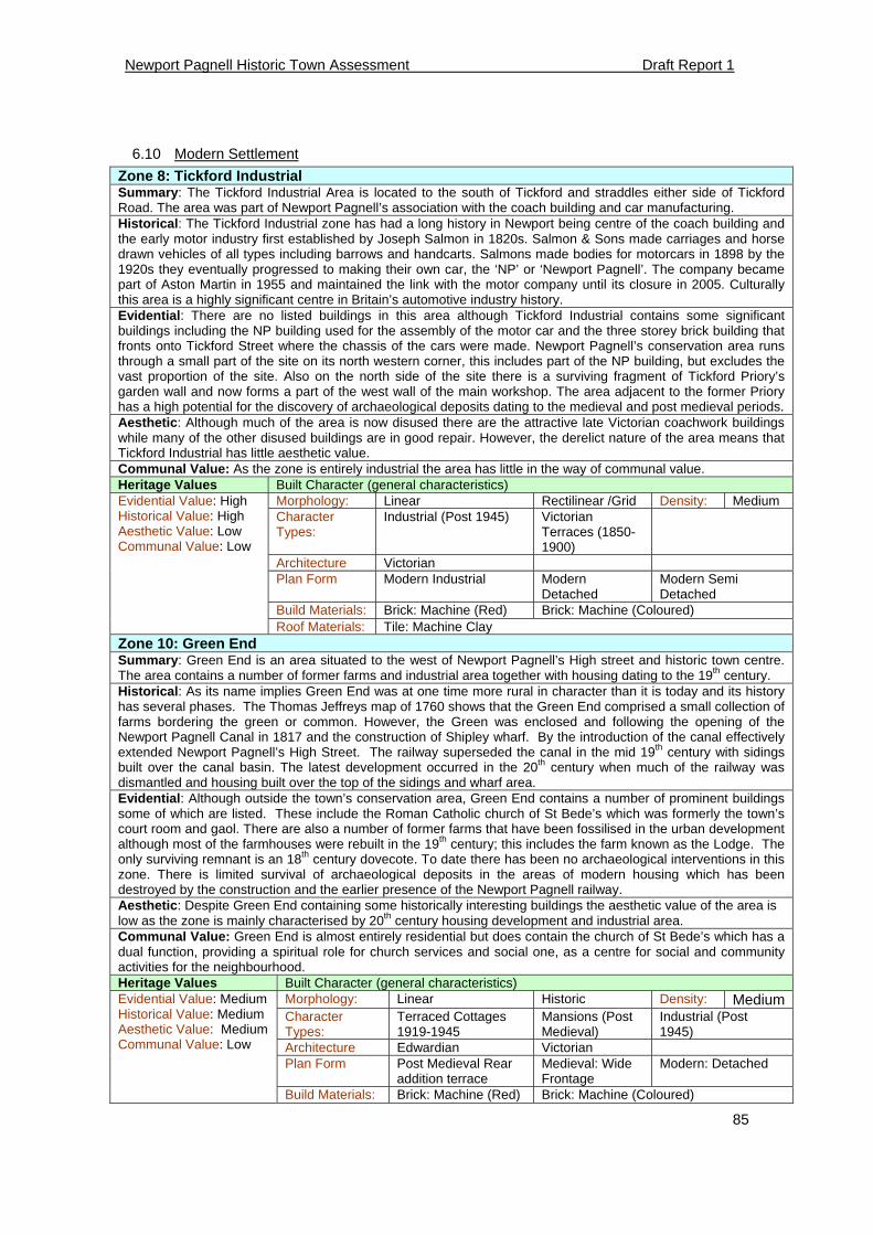
Newport Pagnell Historic Town Assessment Draft Report 1
85
6.10 Modern Settlement
Zone 8: Tickford Industrial Summary: The Tickford Industrial Area is located to the south of Tickford and straddles either side of Tickford Road. The area was part of Newport Pagnell’s association with the coach building and car manufacturing. Historical: The Tickford Industrial zone has had a long history in Newport being centre of the coach building and the early motor industry first established by Joseph Salmon in 1820s. Salmon & Sons made carriages and horse drawn vehicles of all types including barrows and handcarts. Salmons made bodies for motorcars in 1898 by the 1920s they eventually progressed to making their own car, the ‘NP’ or ‘Newport Pagnell’. The company became part of Aston Martin in 1955 and maintained the link with the motor company until its closure in 2005. Culturally this area is a highly significant centre in Britain’s automotive industry history. Evidential: There are no listed buildings in this area although Tickford Industrial contains some significant buildings including the NP building used for the assembly of the motor car and the three storey brick building that fronts onto Tickford Street where the chassis of the cars were made. Newport Pagnell’s conservation area runs through a small part of the site on its north western corner, this includes part of the NP building, but excludes the vast proportion of the site. Also on the north side of the site there is a surviving fragment of Tickford Priory’s garden wall and now forms a part of the west wall of the main workshop. The area adjacent to the former Priory has a high potential for the discovery of archaeological deposits dating to the medieval and post medieval periods. Aesthetic: Although much of the area is now disused there are the attractive late Victorian coachwork buildings while many of the other disused buildings are in good repair. However, the derelict nature of the area means that Tickford Industrial has little aesthetic value. Communal Value: As the zone is entirely industrial the area has little in the way of communal value. Heritage Values Built Character (general characteristics)
Morphology: Linear Rectilinear /Grid Density: Medium Character Types:
Industrial (Post 1945) Victorian Terraces (1850-1900)
Architecture Victorian Plan Form Modern Industrial Modern
Detached Modern Semi Detached
Build Materials: Brick: Machine (Red) Brick: Machine (Coloured)
Evidential Value: High Historical Value: High Aesthetic Value: Low Communal Value: Low
Roof Materials: Tile: Machine Clay Zone 10: Green End Summary: Green End is an area situated to the west of Newport Pagnell’s High street and historic town centre. The area contains a number of former farms and industrial area together with housing dating to the 19th century. Historical: As its name implies Green End was at one time more rural in character than it is today and its history has several phases. The Thomas Jeffreys map of 1760 shows that the Green End comprised a small collection of farms bordering the green or common. However, the Green was enclosed and following the opening of the Newport Pagnell Canal in 1817 and the construction of Shipley wharf. By the introduction of the canal effectively extended Newport Pagnell’s High Street. The railway superseded the canal in the mid 19th century with sidings built over the canal basin. The latest development occurred in the 20th century when much of the railway was dismantled and housing built over the top of the sidings and wharf area. Evidential: Although outside the town’s conservation area, Green End contains a number of prominent buildings some of which are listed. These include the Roman Catholic church of St Bede’s which was formerly the town’s court room and gaol. There are also a number of former farms that have been fossilised in the urban development although most of the farmhouses were rebuilt in the 19th century; this includes the farm known as the Lodge. The only surviving remnant is an 18th century dovecote. To date there has been no archaeological interventions in this zone. There is limited survival of archaeological deposits in the areas of modern housing which has been destroyed by the construction and the earlier presence of the Newport Pagnell railway. Aesthetic: Despite Green End containing some historically interesting buildings the aesthetic value of the area is low as the zone is mainly characterised by 20th century housing development and industrial area. Communal Value: Green End is almost entirely residential but does contain the church of St Bede’s which has a dual function, providing a spiritual role for church services and social one, as a centre for social and community activities for the neighbourhood. Heritage Values Built Character (general characteristics)
Morphology: Linear Historic Density: Medium Character Types:
Terraced Cottages 1919-1945
Mansions (Post Medieval)
Industrial (Post 1945)
Architecture Edwardian Victorian Plan Form Post Medieval Rear
addition terrace Medieval: Wide Frontage
Modern: Detached
Evidential Value: Medium Historical Value: Medium Aesthetic Value: Medium Communal Value: Low
Build Materials: Brick: Machine (Red) Brick: Machine (Coloured)
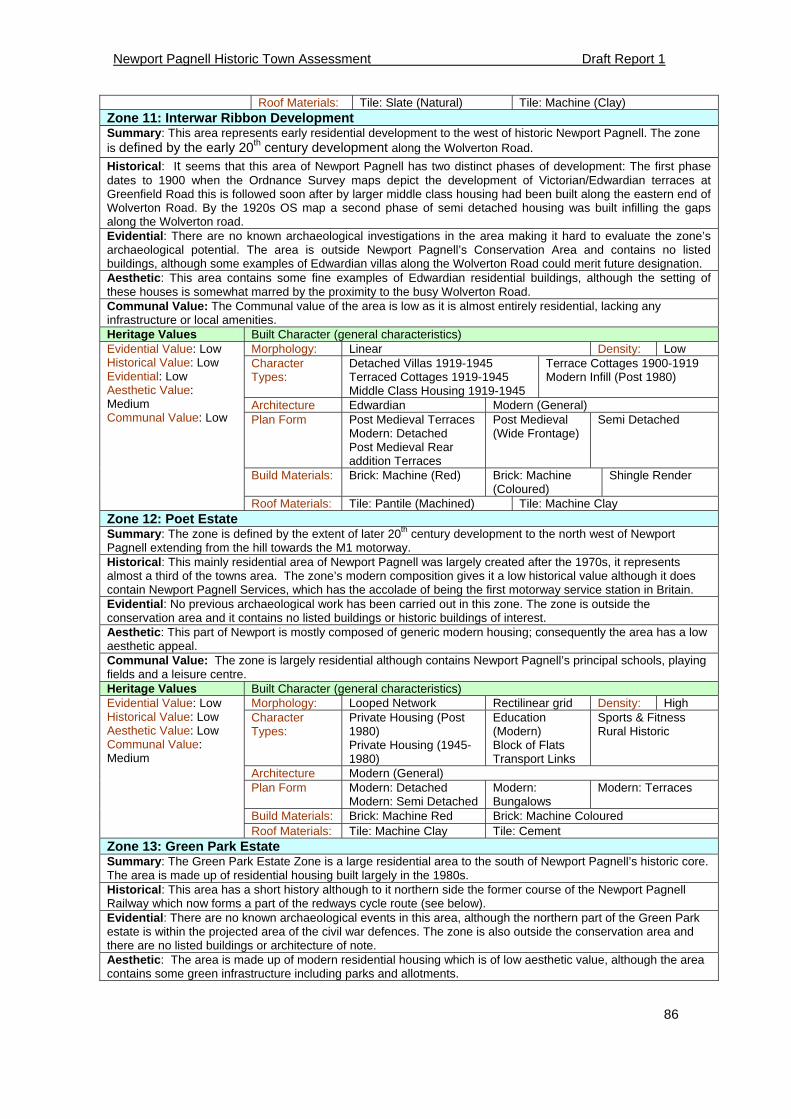
Newport Pagnell Historic Town Assessment Draft Report 1
86
Roof Materials: Tile: Slate (Natural) Tile: Machine (Clay) Zone 11: Interwar Ribbon Development Summary: This area represents early residential development to the west of historic Newport Pagnell. The zone is defined by the early 20th century development along the Wolverton Road.
Historical: It seems that this area of Newport Pagnell has two distinct phases of development: The first phase dates to 1900 when the Ordnance Survey maps depict the development of Victorian/Edwardian terraces at Greenfield Road this is followed soon after by larger middle class housing had been built along the eastern end of Wolverton Road. By the 1920s OS map a second phase of semi detached housing was built infilling the gaps along the Wolverton road. Evidential: There are no known archaeological investigations in the area making it hard to evaluate the zone’s archaeological potential. The area is outside Newport Pagnell’s Conservation Area and contains no listed buildings, although some examples of Edwardian villas along the Wolverton Road could merit future designation. Aesthetic: This area contains some fine examples of Edwardian residential buildings, although the setting of these houses is somewhat marred by the proximity to the busy Wolverton Road. Communal Value: The Communal value of the area is low as it is almost entirely residential, lacking any infrastructure or local amenities. Heritage Values Built Character (general characteristics)
Morphology: Linear Density: Low Character Types:
Detached Villas 1919-1945 Terraced Cottages 1919-1945 Middle Class Housing 1919-1945
Terrace Cottages 1900-1919 Modern Infill (Post 1980)
Architecture Edwardian Modern (General) Plan Form Post Medieval Terraces
Modern: Detached Post Medieval Rear addition Terraces
Post Medieval (Wide Frontage)
Semi Detached
Build Materials: Brick: Machine (Red) Brick: Machine (Coloured)
Shingle Render
Evidential Value: Low Historical Value: Low Evidential: Low Aesthetic Value: Medium Communal Value: Low
Roof Materials: Tile: Pantile (Machined) Tile: Machine Clay Zone 12: Poet Estate Summary: The zone is defined by the extent of later 20th century development to the north west of Newport Pagnell extending from the hill towards the M1 motorway. Historical: This mainly residential area of Newport Pagnell was largely created after the 1970s, it represents almost a third of the towns area. The zone’s modern composition gives it a low historical value although it does contain Newport Pagnell Services, which has the accolade of being the first motorway service station in Britain. Evidential: No previous archaeological work has been carried out in this zone. The zone is outside the conservation area and it contains no listed buildings or historic buildings of interest. Aesthetic: This part of Newport is mostly composed of generic modern housing; consequently the area has a low aesthetic appeal. Communal Value: The zone is largely residential although contains Newport Pagnell’s principal schools, playing fields and a leisure centre. Heritage Values Built Character (general characteristics)
Morphology: Looped Network Rectilinear grid Density: High Character Types:
Private Housing (Post 1980) Private Housing (1945-1980)
Education (Modern) Block of Flats Transport Links
Sports & Fitness Rural Historic
Architecture Modern (General) Plan Form Modern: Detached
Modern: Semi Detached Modern: Bungalows
Modern: Terraces
Build Materials: Brick: Machine Red Brick: Machine Coloured
Evidential Value: Low Historical Value: Low Aesthetic Value: Low Communal Value: Medium
Roof Materials: Tile: Machine Clay Tile: Cement Zone 13: Green Park Estate Summary: The Green Park Estate Zone is a large residential area to the south of Newport Pagnell’s historic core. The area is made up of residential housing built largely in the 1980s. Historical: This area has a short history although to it northern side the former course of the Newport Pagnell Railway which now forms a part of the redways cycle route (see below). Evidential: There are no known archaeological events in this area, although the northern part of the Green Park estate is within the projected area of the civil war defences. The zone is also outside the conservation area and there are no listed buildings or architecture of note. Aesthetic: The area is made up of modern residential housing which is of low aesthetic value, although the area contains some green infrastructure including parks and allotments.
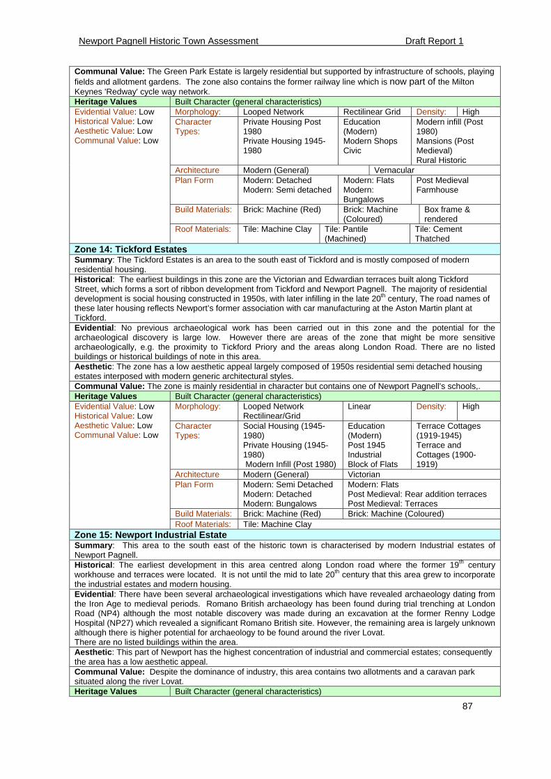
Newport Pagnell Historic Town Assessment Draft Report 1
87
Communal Value: The Green Park Estate is largely residential but supported by infrastructure of schools, playing fields and allotment gardens. The zone also contains the former railway line which is now part of the Milton Keynes 'Redway' cycle way network. Heritage Values Built Character (general characteristics)
Morphology: Looped Network Rectilinear Grid Density: High Character Types:
Private Housing Post 1980 Private Housing 1945-1980
Education (Modern) Modern Shops Civic
Modern infill (Post 1980) Mansions (Post Medieval) Rural Historic
Architecture Modern (General) Vernacular Plan Form Modern: Detached
Modern: Semi detached Modern: Flats Modern: Bungalows
Post Medieval Farmhouse
Build Materials: Brick: Machine (Red) Brick: Machine (Coloured)
Box frame & rendered
Evidential Value: Low Historical Value: Low Aesthetic Value: Low Communal Value: Low
Roof Materials: Tile: Machine Clay Tile: Pantile (Machined)
Tile: Cement Thatched
Zone 14: Tickford Estates Summary: The Tickford Estates is an area to the south east of Tickford and is mostly composed of modern residential housing. Historical: The earliest buildings in this zone are the Victorian and Edwardian terraces built along Tickford Street, which forms a sort of ribbon development from Tickford and Newport Pagnell. The majority of residential development is social housing constructed in 1950s, with later infilling in the late 20th century, The road names of these later housing reflects Newport’s former association with car manufacturing at the Aston Martin plant at Tickford. Evidential: No previous archaeological work has been carried out in this zone and the potential for the archaeological discovery is large low. However there are areas of the zone that might be more sensitive archaeologically, e.g. the proximity to Tickford Priory and the areas along London Road. There are no listed buildings or historical buildings of note in this area. Aesthetic: The zone has a low aesthetic appeal largely composed of 1950s residential semi detached housing estates interposed with modern generic architectural styles. Communal Value: The zone is mainly residential in character but contains one of Newport Pagnell’s schools,. Heritage Values Built Character (general characteristics)
Morphology: Looped Network Rectilinear/Grid
Linear Density: High
Character Types:
Social Housing (1945-1980) Private Housing (1945-1980) Modern Infill (Post 1980)
Education (Modern) Post 1945 Industrial Block of Flats
Terrace Cottages (1919-1945) Terrace and Cottages (1900-1919)
Architecture Modern (General) Victorian Plan Form Modern: Semi Detached
Modern: Detached Modern: Bungalows
Modern: Flats Post Medieval: Rear addition terraces Post Medieval: Terraces
Build Materials: Brick: Machine (Red) Brick: Machine (Coloured)
Evidential Value: Low Historical Value: Low Aesthetic Value: Low Communal Value: Low
Roof Materials: Tile: Machine Clay Zone 15: Newport Industrial Estate Summary: This area to the south east of the historic town is characterised by modern Industrial estates of Newport Pagnell. Historical: The earliest development in this area centred along London road where the former 19th century workhouse and terraces were located. It is not until the mid to late 20th century that this area grew to incorporate the industrial estates and modern housing. Evidential: There have been several archaeological investigations which have revealed archaeology dating from the Iron Age to medieval periods. Romano British archaeology has been found during trial trenching at London Road (NP4) although the most notable discovery was made during an excavation at the former Renny Lodge Hospital (NP27) which revealed a significant Romano British site. However, the remaining area is largely unknown although there is higher potential for archaeology to be found around the river Lovat. There are no listed buildings within the area. Aesthetic: This part of Newport has the highest concentration of industrial and commercial estates; consequently the area has a low aesthetic appeal. Communal Value: Despite the dominance of industry, this area contains two allotments and a caravan park situated along the river Lovat. Heritage Values Built Character (general characteristics)

Newport Pagnell Historic Town Assessment Draft Report 1
88
Morphology: Looped Network Linear Density: High Character Types:
Post 1945 Industrial Cemetery Modern Infill (Post 1980) Modern: Semi Detached
Modern: Detached Caravan park Terraces 1919-1945 Allotments
Architecture Modern (General) Edwardian Plan Form Modern: Semi Detached
Modern: Detached Modern: Terrace
Build Materials: Brick: Machine (Red) Brick: Machine (Coloured)
Evidential Value: Medium Historical Value: Low Aesthetic Value: Low Communal Value: Low
Roof Materials: Tile: Machine Clay
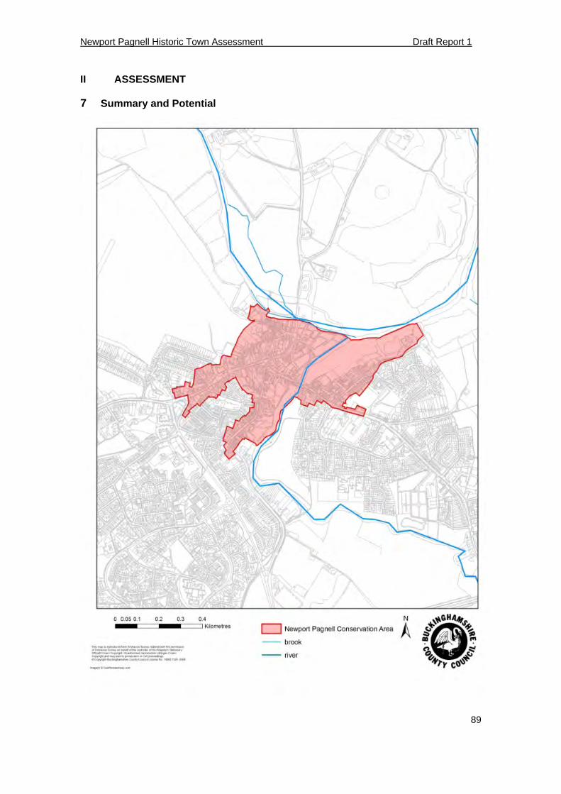
Newport Pagnell Historic Town Assessment Draft Report 1
89
II ASSESSMENT
7 Summary and Potential

Newport Pagnell Historic Town Assessment Draft Report 1
90
Figure 35: Extent of the conservation area, 2009
Newport Pagnell Historic Town Assessment Draft Report 1
91
7.1 Conservation Areas (CA)
A conservation area for Newport Pagnell was first designated in 1972 and revised in 2009 to incorporate elements of the former Aston Martin Lagonda works.
7.2 Scheduled Ancient Monuments (SAMs)
There are two SAMs recorded within Newport Pagnell; the remnants of the Civil War earthwork defences at the southern end of Bury Field (SAM 35992) and Tickford Bridge the 19th century iron bridge (SAM 97).
7.3 Historic Character
Despite the incremental growth of Milton Keynes to the south and west of the town Newport Pagnell has retained its identity as a historic market town. Buildings predominately in the vernacular style border the narrow winding lanes around the High street and Union Street. Georgian architecture appears in significant numbers. The historic core of the town has remained relatively intact with some modern infill and development along the High Street. The majority of recent development on the outskirts of the town has been built in a modern general style. The morphology of the historic core of Newport Pagnell was largely defined by the post medieval period and has remained unchanged from then on.
7.4 Archaeological Potential
The main visible archaeological monuments above ground are the remains of the civil war defences adjacent to Bury field; there are also earthworks within the cemetery, often referred to as both the remnants of 11th century de Somery’s castle and 17th century Civil War ‘the battery’. Newport Pagnell contains a wealth of historic buildings including the church but also many dated to the 17th and 18th centuries. However, there is the possibility that some of these buildings could date to an earlier period; which the results of detailed structural surveys identifying construction techniques and dendrochronology of timber beams may indicate an earlier origin.
Archaeological intervention in Newport Pagnell has been extensive but small in scale; the results of excavations and watching-briefs undertaken in the town have demonstrated that both stratified deposits and cut features survive. From excavations it is known that substantial stratified deposits exist in the main town while it is possible that the Head deposits mapped in the centre of the town could have covered and preserved early prehistoric occupation remains, although this remains unproven. The clay soils covering limestone makes the ground conditions conducive for the preservation of ceramics, metal and bone. Waterlogged deposits have been found along the terraces of the rivers Ouse and Lovat and it is known that these provide the environment for the anaerobic preservation of organic materials. Overall, Newport Pagnell has a good potential for the discovery of archaeological features within the historic core.
Newport Pagnell Historic Town Assessment Draft Report 1
92
III RESEARCH AGENDA
8 Research Agenda
Understanding the development and function of the Anglo Saxon, medieval and post-medieval market town and the testing of theories on social action, economy, politics etc. have been highlighted as an important area of study at the national level (English Heritage, 1997) and at regional and local level (Solent-Thames Research Framework ,forthcoming). The following areas of research have been identified from the compilation of the Historic Town Report and from analysis of historical documentation by Kim Taylor-Moore (Appendix 2).
Prehistoric
To investigate the possibility of earlier settlement in and around the town
Roman
The landscape surrounding Newport Pagnell has yielded some evidence in the archaeological record for Roman sites, including, a 2nd century settlement at Tickford. Fieldwork should assess the possibility of a Roman settlement in Newport Pagnell and relationship with the nearby Romano British settlements including Ashfurlong, Olney to the north and the town of Magiovinium to the south.
Anglo-Saxon
To date, very little is known about the extent of the Anglo Saxon Newport Pagnell beyond what has been hypothesised from cartographic and documentary studies (Robinson 1975; Baines 1987). Further research could help determine:
Whether or not Newport was an Anglo Saxon burh. Further archaeological investigation to establish the presence of Anglo Saxon defences.
The probable/actual location of the Anglo Saxon mint.
The location of the Anglo Saxon church within Newport. Whether the church had the status of a minster?
Medieval
To establish a date for the layout of burgage plots in the High Street. Origins of the medieval town plan including the layout of burgage plots and main streets
To establish the location of the of 11th/12th century castle which is still uncertain in Newport Pagnell.
Where was Newport’s medieval manor house?
The analysis of the spatial distribution of medieval pottery from the excavations in Newport Pagnell in the context of other fabric types found in the county.
To determine the extent of the medieval hospital of St John the Baptist and St John the Evangelist, located near to Tickford Bridge.
The location of the leper hospital dedicated to St Margaret thought to be in the neighbouring parish of Lathbury.
What was the extent and location of Newport’s medieval market?
What was the economy of medieval Newport? What forms of trade and industry existed during this period?
Post Medieval
What evidence is there for the former Civil War defences at Newport? Beyond the

Newport Pagnell Historic Town Assessment Draft Report 1
93
scheduled earthworks in Bury Field?
What evidence is there for the industries of Lace, tanning and parchment making?
An investigation of the socio & economic relationship of Newport Pagnell with the surrounding rural villages especially Tickford and Caldecote.
Newport Pagnell Historic Town Assessment Draft Report 1
94
9 References
9.1 Map Sources
1644 Plan of fortifications of Newport Pagnell by Capt C. Vandenboome, Engineer ‘A True map and description of the fortification of Newport Pagnell AD 1644 (Bodleian Library MS)
1678-1888 Former Open fields of Newport Pagnell (DC 13/3/12)
1808 Map of Tickford Park and farms adjoining in the parish of Newport Pagnell in the county of Buckingham the property of Frederick Hendrick Van Hagen Esq. (Ma/254/1 T)
1808 Enclosure Map Tickford Field (IR/67.3)
1808 Enclosure Map (IR67.1.R.)
1813 Proposed canal (P/V A.24 R)
1814 Newport Pagnell Canal Company seal
1814 Coloured plan of Farm? At Tickford (Rough Plan)
1821 Plan of the priory estate belonging to Phillip Hoddle Ward (BAS Coll 251/45)
1845 Tithe apportionment map (PR 153/27/1)
1876- 1894 Plan of Cottages sites, Silver Street (D/B 396)
Late 19th C. Plan of Tickford Park Estate in the parish of Newport Pagnell
9.2 Trade Directories
Universal British Directory 1790-98. London. Kelly’s Directory of Buckinghamshire: 1903; 1920; 1935. London. Pigot's Directory of Buckinghamshire. 1823-24; 1831; 1842; 1850; 1864; 1877; 1887; 1895
9.3 Bibliography
Albion Archaeology. May 2006. 98 High Street. Trial Trenching. Records of Buckinghamshire 46. SP 8733 4385
Appleton, C 2006 'Renny Lodge, Newport Pagnell, Milton Keynes - Fieldwork Assessment Report' (Wessex Archaeology)
Appleton C, 2005 'Archaeological Works at Renny Lodge Hospital, Newport Pagnell, Milton Keynes' (Wessex Archaeology)
Archaeologica. 2000. Tickford Abbey. Watching Brief. In Records of Buckinghamshire 40. SP 8831 4400
Archaeologica. High Street. SP 4873 2437 to 4878 2442. In Records of Buckinghamshire 42: 157. Watching Brief
5 Paggs Court. Archaeologica Watching Brief. In Records of Buckinghamshire 43. SP 8759 4380.
Archaeologica. 2005. St Johns Street & Silver Street. In Records of Buckinghamshire 45. SP 8763 4389
Archaeologica. 2005. 47-49 High Street. Watching Brief. In Records of Buckinghamshire 45. SP 8766 4393
Archaeologica. 2005. High Street. Watching Brief. In Records of Buckinghamshire 45. SP 8760 4390.
Archaeologica. 2005. 1a Union Street. Watching Brief. In Records of Buckinghamshire 45. SP 8770 4405
Archaeologica 2003 Report on an Archaeological Evaluation at 8 St John's Street & 1 Silver Street, Newport Pagnell, Milton Keynes.
Newport Pagnell Historic Town Assessment Draft Report 1
95
Land at Willen Road. Trial Trenching. Archaeologica In Records of Buckinghamshire 47:1. SP
8750 4230 High Street. Archaeologica. Watching Brief. In Records of Buckinghamshire 47: 1. SP 4875
2439 40-42 High Street. Archaeologica. Watching Brief. In Records of Buckinghamshire 43. SP 8768
4398. Archaeological Solutions. June 2006. London Road Allotments. Trial Trenching. In Records of
Buckinghamshire 46. SP 8846 4318 ASC. James Yard. Watching Brief. In Records of Buckinghamshire 41. SP 8740 4390 Riverside House. ASC. Watching Brief. In Records of Buckinghamshire 41. SP 8770 4380 Kickles Farm, Castle & Riverside Meadows. Watching Brief. ASC. In Records of
Buckinghamshire 41. ASC Cedars Combined School. Trial Trenching, In Records of Buckinghamshire 41. SP 8740
4370 ASC. Oct 005. 29 High Street. Building Survey. In Records of Buckinghamshire 45. SP 4395
8768 ASC. September 2006. Ironbridge Works. Watching Brief. In Records of Buckinghamshire 46.
SP 8782 4377 ASC. March 2006.’Moat Cottage Caldecote. Trial Trenching’. In Records of Buckinghamshire
46. SP 8828 4234 ASC. Oct 2006. Caldecote Farm Cottage. Watching Brief. In Records of Buckinghamshire 46.
SP 8805 4239 Baines, A. 1986. The Origins of the Borough of Newport Pagnell. In Records of
Buckinghamshire 28: 128-137.
Beamish, H. & Parkhouse, J. 1991 'New archaeological evidence for Anglo-Saxon activity at Newport Pagnell', Records of Buckinghamshire 33, 145-147
Beamish, H. 1991. Watching Brief Union Street. BCMAS. In Records of Buckinghamshire 31: 1991: 152.
BCMAS. Tickford Abbey. Watching Brief. In Records of Buckinghamshire 38. SP883 440 In Records of Buckinghamshire 47: 2. Chapman A. Excavations Boon, C. 1981 ‘A Roman Bronze Tripod Foot from Stanton Low near Newport Pagnell’
Antiquities Journal 61
Brooks, N. P. 1964 ‘The unidentified forts of the Burghal Hidage,’ Medieval Archaeology VII pp.74-89.
Brown, M. 2007 ABC: A Brewers’ Compendium: A Directory of Buckinghamshire Brewers (Brewery Historical Society Publication)
Bullard, A. 1933 The Buckinghamshire Standard
Bull, F.W. 1900 A History of Newport Pagnell (Kessinger) Chapman, A. 2007 ‘A Bronze Age Barrow Cemetery and later Pit Alignments and Enclosures at
Gayhurst Quarry. Newport Pagnell’, Buckinghamshire Records of Buckinghamshire Vol 47 Part 2 pp. 83-211
Chibnall, Prof A.C. 1965 Sherington - Fiefs and Fields of a Buckinghamshire Village (Cambridge University Press)
Crank, N. HAT. Mill House Stable. Archaeological Evaluation. SP 8754 4414. In Records of Buckinghamshire 42: 159.
Crank N 2004 Watching brief on land at Ironbridge Works, Tickford Street, Newport Pagnell, Milton Keynes" AS&C Unpublished Report
Creaser, J. 1974. ‘Grounds of Tickford Abbey’. In Records of Buckinghamshire 20: 2. SP 8832 4405
Dyer, J. 1990 Ancient Britain (Batsford) Farley, M & Knight D. 1986 ‘Two Iron Age Sites on the Newport Pagnell Bypass’. In Records of
Newport Pagnell Historic Town Assessment Draft Report 1
96
Buckinghamshire 28: 148-163 30-32 High Street. Heritage Network Ltd. Watching Brief. In Records of Buckinghamshire 41.
87708 43977 126 High Street. RJ Ivens. Watching Brief. In Records of Buckinghamshire 43. SP 8726 4381. Field, J 1999 "The Old Fire Station, Newport Pagnell" Network Archaeology South Midlands Archaeology 34 (2004), 24;
Fleming, A.J. 1972 ‘Notes on Archaeology of Newport Pagnell’ collated for C.B.A. Urban Research Committee (CBA)
Fleming, A.J. 1971 ‘Notes on Archaeology of Newport Pagnell A Hundred Town 1825-75’ Unpublished dissertation presented to Eng. Local History Dept (Leicester University)
Freese, S. 2007 The Watermills of Buckinghamshire: A 1930s account (Buckinghamshire Archaeological Society)
Giggins, B 2007 Astons Martin Works, Tickford Street, Newport Pagnell: Brief History of the Site and Notes on the Buildings (Milton Keynes Council – Unpublished Report)
Grassam, A. & Williams, J. 2004 "London Road Allotments, Newport Pagnell - an archaeological evaluation" Trial Trenching (Archaeological Solutions – Unpublished Report)
Green, D. & Kidd, A. 2006 Buckinghamshire & Milton Keynes Historic Landscape Characterisation (Buckinghamshire County Council English Heritage)
Green, H.S. 1973 ‘A polished stone axe from Kickles Farm’ Records of Buckinghamshire 19 Grigg, A.E. 1985 Country Railwaymen: A Notebook of Engine Drivers Tales (Blandford Press)
Hancock 2007 'Watching Brief: Rear of 74 Union Street, Newport Pagnell, Milton Keynes' Archaeological Services & Consultancy Ltd (Unpublished Report)
Hancock, A. J. 2006 'Watching Brief: Footbridge, Castle Meadow, Newport Pagnell' Archaeological Services & Consultancy Ltd (Unpublished Report)
Haslam, J. 1985 Early Medieval Towns in Britain c.700 1100 (Princes Risborough)
Holmes, M 1998 "Archaeological watching brief at the "Barn", 3, Waterhouse Close, Newport Pagnell. (Northamptonshire Archaeology) (Unpublished Report)
Hounsell D & Abrams J 2004 Land at 98 High Street, Newport Pagnell, Milton Keynes - archaeological field evaluation'; (Unpublished Report)
Hunn, J.R. 2005 'Archaeological Evaluation: Land to the West of Caldecote Farm, Willen Road, Newport Pagnell' (Unpublished Report)
Ivens, R. & Lisboa I. 2004 "Watching brief , The A1 Food Hall Site, High Street / St John Street, Newport Pagnell, Milton Keynes" (Unpublished Report)
Ivens, R 2003 "Report on an archaeological watching brief at 1a Union Street, Newport Pagnell, Milton Keynes"
Ivens, R. 2002. Old Fire Station. Watching Brief. In Records of Buckinghamshire 42: 159 SP (Unpublished Report)
Ivens, R. 2001 " Archaeological Watching Brief at 126 High St, Newport Pagnell, Milton Keynes"
Keir, W 2010 ‘William Cowley Parchment Works, Caldecote St, Newport Pagnell: Archaeological Test Pit Evaluation’ (unpublished report).
King, I. 2001 'An archaeological Watching brief on the flood defences at Castle Meadow, Newport Pagnell, Milton Keynes'
Lewis, M. 1993 Tickford Priory: A Benedictine Tragedy (Unpublished thesis)
Lisboa Dr. I. 2002a '5 Paggs Court, Newport Pagnell, Milton Keynes' (Unpublished Report)
Lisboa, Dr I. 2002b '40-42 High Street, Newport Pagnell, Milton Keynes' (Unpublished Report)
Lisboa, Dr I. 2002c 'Report on a watching brief at High Street, Newport Pagnell, Buckinghamshire' (Unpublished Report)
Newport Pagnell Historic Town Assessment Draft Report 1
97
Lisboa, I 2002c 'High Street Public Toilets, Newport Pagnell, Milton Keynes' (Unpublished Report)
Lodoen A & Ingham D 2008 '4-6 Union Street, Newport Pagnell, Milton Keynes: Archaeological Field Evaluation' (Albion Archaeology / Bedfordshire County Archaeological Service)
Mawer, A. & Stenton, J.M. 1925 Place Names of Buckinghamshire
Meckseper, C & Cooper-Reade, H 2010 ‘William Cowley Parchment Works, Caldecote St, Newport Pagnell: A Programme of Historic Building Recording’ (unpublished report).
Milln, J. 1977. Some Flints from Newport Pagnell. In Records of Buckinghamshire 20: 2: 400-404.
Northants. Waterhouse Close. In Records of Buckinghamshire 40. SP 8766 4375. Phoenix. 2006. 93 High Street. Watching Brief. In Records of Buckinghamshire 46. Milton Keynes Council 2007 Aston Martin Site: Tickford Street (north side) Newport Pagnell Development Constraints Brief (Milton Keynes Council) Mynard, D.C. 2007 Salmons and Sons: The Tickford Coach Builders (Phillimore) Mynard, D.C. & Hunt, J. 1995 Newport Pagnell a Pictorial History (Phillimore) Mynard, D.C; Woodfield, P & Bailey, R 2009 Newport Pagnell’s Bridges: The: Tickford Iron
Bridge in Context (Phillimore) NBAS. 2002. ‘Excavations at Tickford Abbey’. SP 883 440. North Bucks Archaeological Society.
In Records of Buckinghamshire 42: 153. Page, W. 1927 Victoria County History, Buckinghamshire Vol. 4 (London) Pevsner, Nikolaus & Williamson, Elizabeth. 1994. The Buildings of England – Buckinghamshire.
(London: Penguin)
Pike, A. 1995 Gazetteer of Buckinghamshire Brickyards (Bucks County Museum)
Reed, C. 1986 The English Town In Decline 1350 -1800 Centre for Urban History (University of Leicester)
Reed, M. 1979 The Buckinghamshire Landscape (Hodder & Stoughton)
Richmond, A. 2005 'Archaeological Watching Brief: 93 High Street, Newport Pagnell, Milton Keynes' (Unpublished Report)
Robinson, J. 1975 The Evolution of the Townscape of Medieval Newport Pagnell in Buckinghamshire: Occasional Paper No. 2 (Bradwell Abbey Field Centre for the Study of Archaeology, Natural History & Environmental Studies)
Roundell, Rev. H. ‘The Garrison of Newport Pagnell during the Civil Wars’ Records of Buckinghamshire 2 pp. 206-216
Sheahan, J 1861 History and Topography of Buckinghamshire (Longman)
Simco, A, 1984 Survey of Bedfordshire: The Roman period, Bedford and London.
Viatores 1964 Roman roads in the south east Midlands (Gollancz, London)
Watson, B. 1994 'Renny Lodge Hospital, London Road, Newport Pagnell, Buckinghamshire: An Archaeological Assessment' (Museum of London Archaeological Service - Unpublished Report)
Wilcox, S 2003 "Historic Building Survey: 29 High Street, Newport Pagnell, Milton Keynes"
Wilson, N 2007 Archaeological Watching Brief: 19 Silver Street, Newport Pagnell, Milton Keynes Archaeological Services & Consultancy Ltd (Unpublished Report)
Wilson, N. ‘77 High Street. ASC. Trial trenching. In Records of Buckinghamshire 44
Wolverton Archaeological Society 1970 Wolverton Historical Journal 6
Woodfield, P 2006 'Proposed Stud Farm Site, Little Linford Lane, Newport Pagnell: Archaeological Field Evaluation'
Woodfield P. 2002a "Ironbridge Works, Tickford Street, Newport Pagnell
Woodfield P. 2002b "No. 38 High Street, Newport Pagnell - An architectural-historical assessment" (Unpublished Report)
Newport Pagnell Historic Town Assessment Draft Report 1
98
Woodfield P. 2001'Lincoln Lodge, 23 Silver Street, Newport Pagnell' (Unpublished Report)
Woodfield P. 1999 " No. 72, Silver Street, Newport Pagnell" Records of Buckinghamshire 4
Woodfield P. 1997 'The Old Kiosk, 26 St John's Street, Newport Pagnell' (Unpublished Report)
Wright, R.V. 1980 ‘A skull of a Neolithic shape from Newport Pagnell, Buckinghamshire’ Records of Buckinghamshire 20
1989. ‘The Geology of Woad Farm Gravel Pit, Newport Pagnell’. In Records of Buckinghamshire 31: 235-237
1991. New Evidence for Anglo-Saxon activity at Newport Pagnell. In Records of Buckinghamshire 33: 145-148
Zeepvat, R. 1999a An Archaeological Watching Brief at James' Yard, Newport Pagnell, Milton Keynes (AS&C Unpublished Report)
Zeepvat, R. 1999b An archaeological watching brief at Riverside House, Riverside, Newport Pagnell (AS&C Unpublished Report)
Zeepvat, R. J. 1993b Roman landscape, in The changing landscape of Milton Keynes (R A Croft and D C Mynard) Buckinghamshire Archaeology Society Monograph Series 5, 11-14,
9.4 Websites
Centre for Metropolitan History. 2007. Letters, S. Gazetteer of Markets and Fairs in England and Wales to 1516. 19/05/08. http://www.history.ac.uk/cmh/gaz/gazweb2.html
Old Towns of England. 2007. Record of article from ‘The Penny Magazine’ 1833-1848. 10/12/07. http://www.oldtowns.co.uk/countyframes/bucks.htm
University of Portsmouth. 2003. A Vision of Britain through Time. 07/12/07. Record of article from John Marius Wilson's Imperial Gazetteer of England and Wales (1870-72). http://www.visionofbritain.org.uk/
University of Portsmouth. 2003. A Vision of Britain through Time. 07/12/07. Record of article from John Bartholomew. Gazetteer of the British Isles (1887) http://www.visionofbritain.org.uk/
The National Archives. 2008. The National Archives: Access to Archives. 11/07/08. Transcript of 1577 Buckinghamshire Return of Vintners, Inn-keepers and Alehouse-keepers in the county. http://www.nationalarchives.gov.uk/A2A/records.aspx?cat=008-dx401500&cid=-1&Gsm=2008-06-18
10 Addresses
Name Address Contact Details
Buckinghamshire County Archaeological Service.
Countryside and Heritage, Buckinghamshire County Council, Annexe A, County Hall, Bucks, HP22 1UY
Tel. 01296-382927
English Heritage South East Region
English Heritage, Eastgate Court, 195-205 High Street, GUILDFORD, Surrey GU1 3EH
Tel. 01483 252000
Milton Keynes Unitary Authority
Archaeology Service, The Civic Offices Milton Keynes Council Civic Offices 1 Saxon Gate East Central Milton Keynes, MK9 3EJ
Tel. 01908 252902
Buckinghamshire Archaeological Society
Buckinghamshire Archaeological Society County Museum Church Street Aylesbury, HP20 2QP
Website: www.bucksas.org.uk

Newport Pagnell Historic Town Assessment Draft Report 1
99
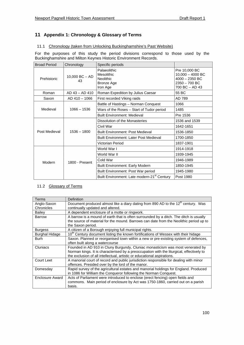
Newport Pagnell Historic Town Assessment Draft Report 1
100
11 Appendix 1: Chronology & Glossary of Terms
11.1 Chronology (taken from Unlocking Buckinghamshire’s Past Website)
For the purposes of this study the period divisions correspond to those used by the Buckinghamshire and Milton Keynes Historic Environment Records.
Broad Period Chronology Specific periods
Prehistoric 10,000 BC – AD
43
Palaeolithic Mesolithic Neolithic Bronze Age Iron Age
Pre 10,000 BC 10,000 – 4000 BC 4000 – 2350 BC 2350 – 700 BC 700 BC – AD 43
Roman AD 43 – AD 410 Roman Expedition by Julius Caesar 55 BC
Saxon AD 410 – 1066 First recorded Viking raids AD 789
Battle of Hastings – Norman Conquest 1066
Wars of the Roses – Start of Tudor period 1485 Medieval 1066 – 1536
Built Environment: Medieval Pre 1536
Dissolution of the Monasteries 1536 and 1539
Civil War 1642-1651
Built Environment: Post Medieval 1536-1850
Built Environment: Later Post Medieval 1700-1850
Post Medieval 1536 – 1800
Victorian Period 1837-1901
World War I 1914-1918
World War II 1939-1945
Cold War 1946-1989
Built Environment: Early Modern 1850-1945
Built Environment: Post War period 1945-1980
Modern 1800 - Present
Built Environment: Late modern-21st Century Post 1980
11.2 Glossary of Terms
Terms Definition Anglo-Saxon Chronicles
Document produced almost like a diary dating from 890 AD to the 12th century. Was continually updated and altered.
Bailey A dependent enclosure of a motte or ringwork. Barrow A barrow is a mound of earth that is often surrounded by a ditch. The ditch is usually
the source of material for the mound. Barrows can date from the Neolithic period up to the Saxon period.
Burgess A citizen of a Borough enjoying full municipal rights. Burghal Hidage 10th Century document listing the known fortifications of Wessex with their hidage Burh Saxon. Planned or reorganised town within a new or pre-existing system of defences,
often built along a watercourse Cluniacs Founded in AD 910 in Cluny Burgundy, Cluniac monasticism was most venerated by
Norman kings. It is characterised by a preoccupation with the liturgical, effectively to the exclusion of all intellectual, artistic or educational aspirations.
Court Leet A manorial court of record and public jurisdiction responsible for dealing with minor offences. Presided over by the lord of the manor.
Domesday Rapid survey of the agricultural estates and manorial holdings for England. Produced in 1086 for William the Conqueror following the Norman Conquest.
Enclosure Award Acts of Parliament were introduced to enclose (erect fencing) open fields and commons. Main period of enclosure by Act was 1750-1860, carried out on a parish basis.
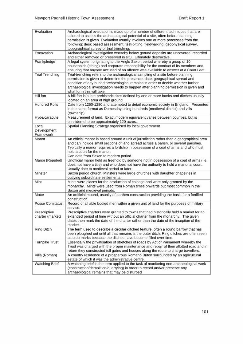
Newport Pagnell Historic Town Assessment Draft Report 1
101
Evaluation Archaeological evaluation is made up of a number of different techniques that are tailored to assess the archaeological potential of a site, often before planning permission is given. Evaluation usually involves one or more processes from the following: desk based assessment, test-pitting, fieldwalking, geophysical survey, topographical survey or trial trenching,
Excavation Archaeological investigation whereby below ground deposits are uncovered, recorded and either removed or preserved in situ. Ultimately destructive.
Frankpledge A legal system originating to the Anglo Saxon period whereby a group of 10 households (tithing) had corporate responsibility for the conduct of its members and ensuring that anyone accused of an offence was available to answer at a Court Leet.
Trial Trenching Trial-trenching refers to the archaeological sampling of a site before planning permission is given to determine the presence, date, geographical spread and condition of any buried archaeological remains in order to decide whether further archaeological investigation needs to happen after planning permission is given and what form this will take
Hill fort A hill fort is a late prehistoric sites defined by one or more banks and ditches usually located on an area of high ground
Hundred Rolls Date from 1250-1280 and attempted to detail economic society in England. Presented in the same format as Domesday using hundreds (medieval district) and vills (township).
Hyde/caracute Measurement of land. Exact modern equivalent varies between counties, but is considered to be approximately 120 acres.
Local Development Framework
Spatial Planning Strategy organised by local government
Manor An official manor is based around a unit of jurisdiction rather than a geographical area and can include small sections of land spread across a parish, or several parishes. Typically a manor requires a lordship in possession of a coat of arms and who must hold a court for the manor. Can date from Saxon to modern period.
Manor [Reputed] Unofficial manor held as freehold by someone not in possession of a coat of arms (i.e. does not have a title) and who does not have the authority to hold a manorial court. Usually date to medieval period or later.
Minster Saxon period church. Minsters were large churches with daughter chapelries in outlying subordinate settlements.
Mint Mints were places for the production of coinage and were only granted by the monarchy. Mints were used from Roman times onwards but most common in the Saxon and medieval periods.
Motte An artificial mound, usually of earthen construction providing the basis for a fortified construction.
Posse Comitatus Record of all able bodied men within a given unit of land for the purposes of military service.
Prescriptive charter (market)
Prescriptive charters were granted to towns that had historically held a market for an extended period of time without an official charter from the monarchy. The given dates then mark the date of the charter rather than the date of the inception of the market.
Ring Ditch The term used to describe a circular ditched feature, often a round barrow that has been ploughed out until all that remains is the outer ditch. Ring ditches are often seen as crop marks because the ditches have become filled over time.
Turnpike Trust Essentially the privatisation of stretches of roads by Act of Parliament whereby the Trust was charged with the proper maintenance and repair of their allotted road and in return they constructed toll gates and houses along the route to charge travellers.
Villa (Roman) A country residence of a prosperous Romano Briton surrounded by an agricultural estate of which it was the administrative centre.
Watching Brief A watching brief is the term applied to the task of monitoring non-archaeological work (construction/demolition/quarrying) in order to record and/or preserve any archaeological remains that may be disturbed
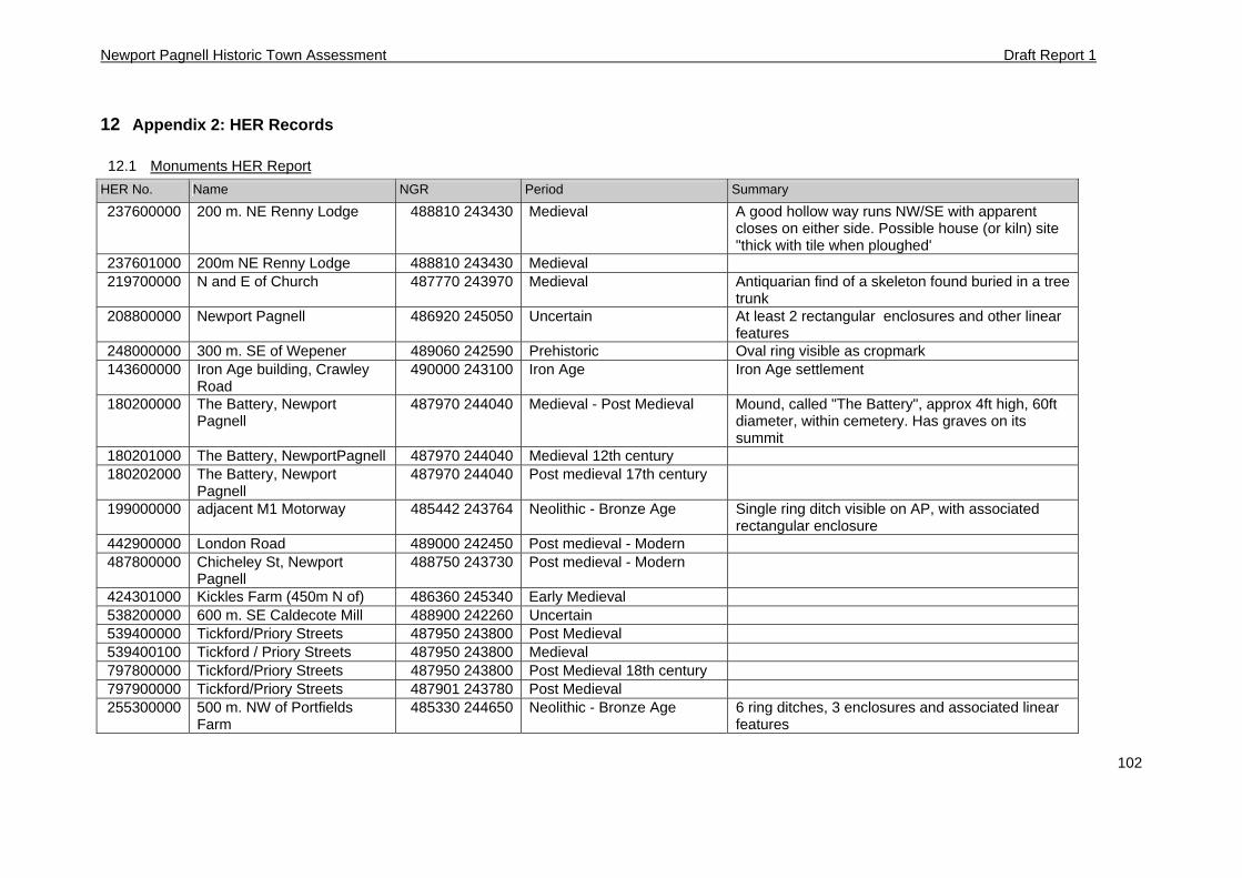
Newport Pagnell Historic Town Assessment Draft Report 1
102
12 Appendix 2: HER Records
12.1 Monuments HER Report
HER No. Name NGR Period Summary
237600000 200 m. NE Renny Lodge 488810 243430 Medieval A good hollow way runs NW/SE with apparent closes on either side. Possible house (or kiln) site "thick with tile when ploughed'
237601000 200m NE Renny Lodge 488810 243430 Medieval 219700000 N and E of Church 487770 243970 Medieval Antiquarian find of a skeleton found buried in a tree
trunk 208800000 Newport Pagnell 486920 245050 Uncertain At least 2 rectangular enclosures and other linear
features 248000000 300 m. SE of Wepener 489060 242590 Prehistoric Oval ring visible as cropmark 143600000 Iron Age building, Crawley
Road 490000 243100 Iron Age Iron Age settlement
180200000 The Battery, Newport Pagnell
487970 244040 Medieval - Post Medieval Mound, called "The Battery", approx 4ft high, 60ft diameter, within cemetery. Has graves on its summit
180201000 The Battery, NewportPagnell 487970 244040 Medieval 12th century 180202000 The Battery, Newport
Pagnell 487970 244040 Post medieval 17th century
199000000 adjacent M1 Motorway 485442 243764 Neolithic - Bronze Age Single ring ditch visible on AP, with associated rectangular enclosure
442900000 London Road 489000 242450 Post medieval - Modern 487800000 Chicheley St, Newport
Pagnell 488750 243730 Post medieval - Modern
424301000 Kickles Farm (450m N of) 486360 245340 Early Medieval 538200000 600 m. SE Caldecote Mill 488900 242260 Uncertain 539400000 Tickford/Priory Streets 487950 243800 Post Medieval 539400100 Tickford / Priory Streets 487950 243800 Medieval 797800000 Tickford/Priory Streets 487950 243800 Post Medieval 18th century 797900000 Tickford/Priory Streets 487901 243780 Post Medieval 255300000 500 m. NW of Portfields
Farm 485330 244650 Neolithic - Bronze Age 6 ring ditches, 3 enclosures and associated linear
features
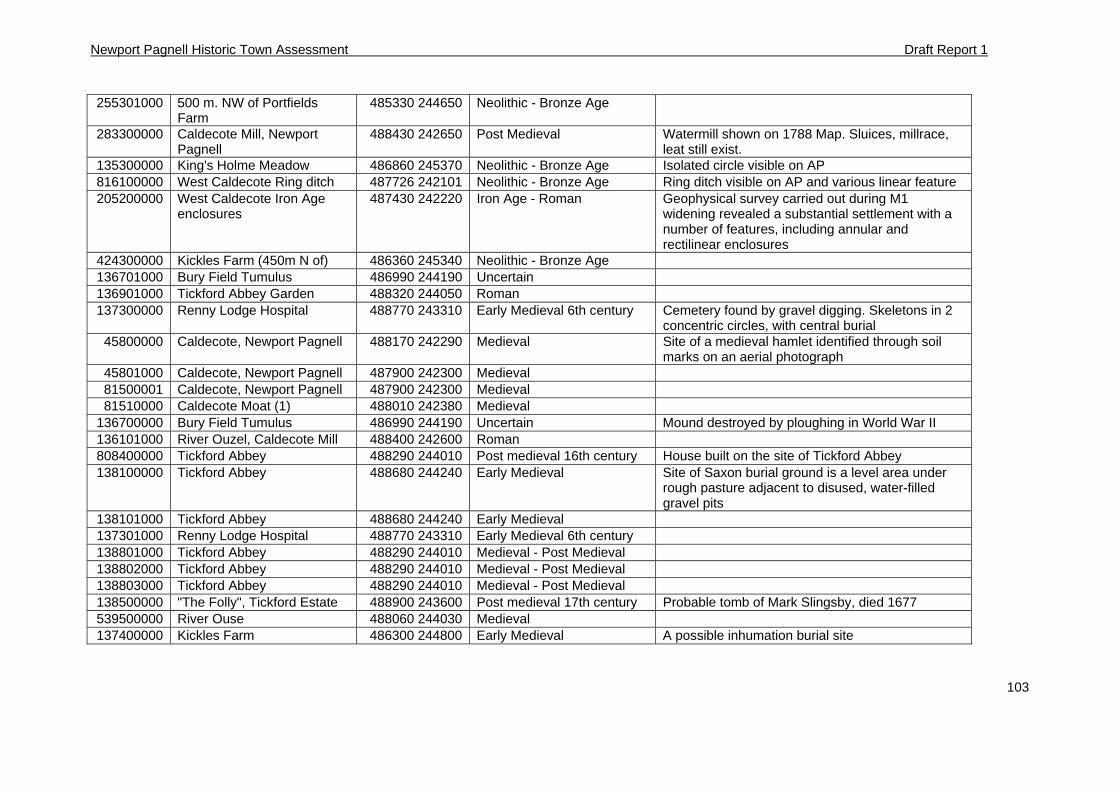
Newport Pagnell Historic Town Assessment Draft Report 1
103
255301000 500 m. NW of Portfields Farm
485330 244650 Neolithic - Bronze Age
283300000 Caldecote Mill, Newport Pagnell
488430 242650 Post Medieval Watermill shown on 1788 Map. Sluices, millrace, leat still exist.
135300000 King's Holme Meadow 486860 245370 Neolithic - Bronze Age Isolated circle visible on AP 816100000 West Caldecote Ring ditch 487726 242101 Neolithic - Bronze Age Ring ditch visible on AP and various linear feature 205200000 West Caldecote Iron Age
enclosures 487430 242220 Iron Age - Roman Geophysical survey carried out during M1
widening revealed a substantial settlement with a number of features, including annular and rectilinear enclosures
424300000 Kickles Farm (450m N of) 486360 245340 Neolithic - Bronze Age 136701000 Bury Field Tumulus 486990 244190 Uncertain 136901000 Tickford Abbey Garden 488320 244050 Roman 137300000 Renny Lodge Hospital 488770 243310 Early Medieval 6th century Cemetery found by gravel digging. Skeletons in 2
concentric circles, with central burial 45800000 Caldecote, Newport Pagnell 488170 242290 Medieval Site of a medieval hamlet identified through soil
marks on an aerial photograph 45801000 Caldecote, Newport Pagnell 487900 242300 Medieval 81500001 Caldecote, Newport Pagnell 487900 242300 Medieval 81510000 Caldecote Moat (1) 488010 242380 Medieval
136700000 Bury Field Tumulus 486990 244190 Uncertain Mound destroyed by ploughing in World War II 136101000 River Ouzel, Caldecote Mill 488400 242600 Roman 808400000 Tickford Abbey 488290 244010 Post medieval 16th century House built on the site of Tickford Abbey 138100000 Tickford Abbey 488680 244240 Early Medieval Site of Saxon burial ground is a level area under
rough pasture adjacent to disused, water-filled gravel pits
138101000 Tickford Abbey 488680 244240 Early Medieval 137301000 Renny Lodge Hospital 488770 243310 Early Medieval 6th century 138801000 Tickford Abbey 488290 244010 Medieval - Post Medieval 138802000 Tickford Abbey 488290 244010 Medieval - Post Medieval 138803000 Tickford Abbey 488290 244010 Medieval - Post Medieval 138500000 "The Folly", Tickford Estate 488900 243600 Post medieval 17th century Probable tomb of Mark Slingsby, died 1677 539500000 River Ouse 488060 244030 Medieval 137400000 Kickles Farm 486300 244800 Early Medieval A possible inhumation burial site
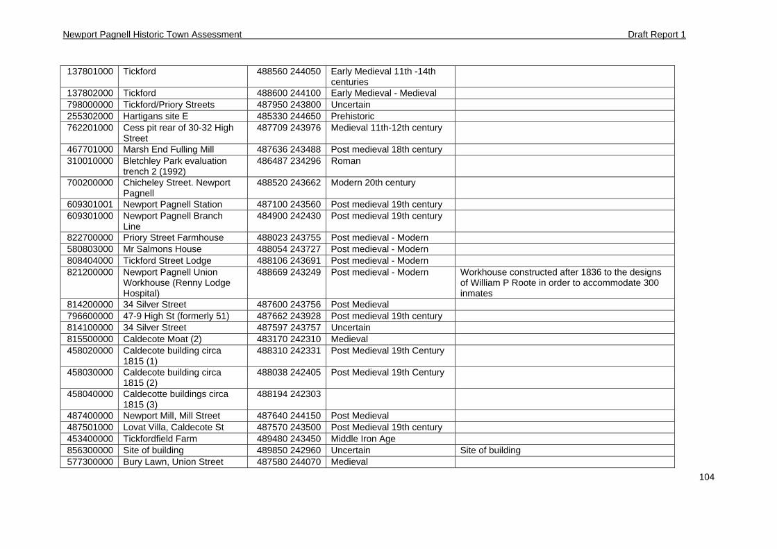
Newport Pagnell Historic Town Assessment Draft Report 1
104
137801000 Tickford 488560 244050 Early Medieval 11th -14th centuries
137802000 Tickford 488600 244100 Early Medieval - Medieval 798000000 Tickford/Priory Streets 487950 243800 Uncertain 255302000 Hartigans site E 485330 244650 Prehistoric 762201000 Cess pit rear of 30-32 High
Street 487709 243976 Medieval 11th-12th century
467701000 Marsh End Fulling Mill 487636 243488 Post medieval 18th century 310010000 Bletchley Park evaluation
trench 2 (1992) 486487 234296 Roman
700200000 Chicheley Street. Newport Pagnell
488520 243662 Modern 20th century
609301001 Newport Pagnell Station 487100 243560 Post medieval 19th century 609301000 Newport Pagnell Branch
Line 484900 242430 Post medieval 19th century
822700000 Priory Street Farmhouse 488023 243755 Post medieval - Modern 580803000 Mr Salmons House 488054 243727 Post medieval - Modern 808404000 Tickford Street Lodge 488106 243691 Post medieval - Modern 821200000 Newport Pagnell Union
Workhouse (Renny Lodge Hospital)
488669 243249 Post medieval - Modern Workhouse constructed after 1836 to the designs of William P Roote in order to accommodate 300 inmates
814200000 34 Silver Street 487600 243756 Post Medieval 796600000 47-9 High St (formerly 51) 487662 243928 Post medieval 19th century 814100000 34 Silver Street 487597 243757 Uncertain 815500000 Caldecote Moat (2) 483170 242310 Medieval 458020000 Caldecote building circa
1815 (1) 488310 242331 Post Medieval 19th Century
458030000 Caldecote building circa 1815 (2)
488038 242405 Post Medieval 19th Century
458040000 Caldecotte buildings circa 1815 (3)
488194 242303
487400000 Newport Mill, Mill Street 487640 244150 Post Medieval 487501000 Lovat Villa, Caldecote St 487570 243500 Post Medieval 19th century 453400000 Tickfordfield Farm 489480 243450 Middle Iron Age 856300000 Site of building 489850 242960 Uncertain Site of building 577300000 Bury Lawn, Union Street 487580 244070 Medieval
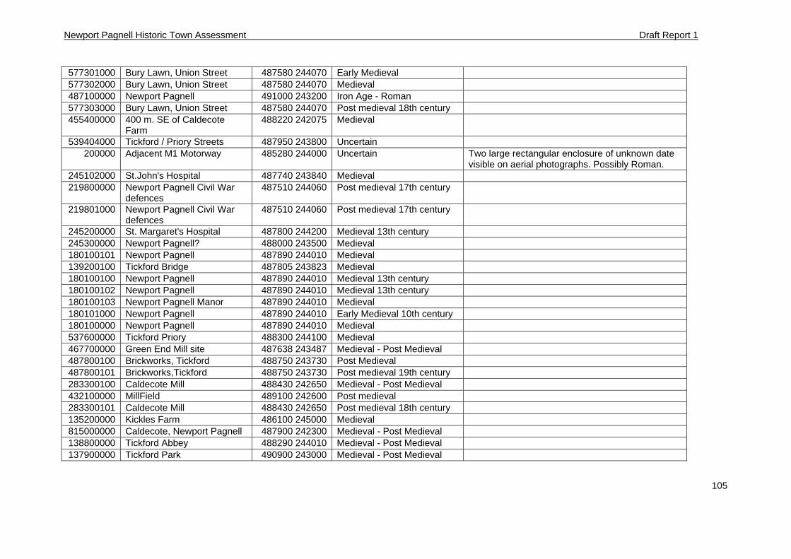
Newport Pagnell Historic Town Assessment Draft Report 1
105
577301000 Bury Lawn, Union Street 487580 244070 Early Medieval 577302000 Bury Lawn, Union Street 487580 244070 Medieval 487100000 Newport Pagnell 491000 243200 Iron Age - Roman 577303000 Bury Lawn, Union Street 487580 244070 Post medieval 18th century 455400000 400 m. SE of Caldecote
Farm 488220 242075 Medieval
539404000 Tickford / Priory Streets 487950 243800 Uncertain 200000 Adjacent M1 Motorway 485280 244000 Uncertain Two large rectangular enclosure of unknown date
visible on aerial photographs. Possibly Roman. 245102000 St.John's Hospital 487740 243840 Medieval 219800000 Newport Pagnell Civil War
defences 487510 244060 Post medieval 17th century
219801000 Newport Pagnell Civil War defences
487510 244060 Post medieval 17th century
245200000 St. Margaret's Hospital 487800 244200 Medieval 13th century 245300000 Newport Pagnell? 488000 243500 Medieval 180100101 Newport Pagnell 487890 244010 Medieval 139200100 Tickford Bridge 487805 243823 Medieval 180100100 Newport Pagnell 487890 244010 Medieval 13th century 180100102 Newport Pagnell 487890 244010 Medieval 13th century 180100103 Newport Pagnell Manor 487890 244010 Medieval 180101000 Newport Pagnell 487890 244010 Early Medieval 10th century 180100000 Newport Pagnell 487890 244010 Medieval 537600000 Tickford Priory 488300 244100 Medieval 467700000 Green End Mill site 487638 243487 Medieval - Post Medieval 487800100 Brickworks, Tickford 488750 243730 Post Medieval 487800101 Brickworks,Tickford 488750 243730 Post medieval 19th century 283300100 Caldecote Mill 488430 242650 Medieval - Post Medieval 432100000 MillField 489100 242600 Post medieval 283300101 Caldecote Mill 488430 242650 Post medieval 18th century 135200000 Kickles Farm 486100 245000 Medieval 815000000 Caldecote, Newport Pagnell 487900 242300 Medieval - Post Medieval 138800000 Tickford Abbey 488290 244010 Medieval - Post Medieval 137900000 Tickford Park 490900 243000 Medieval - Post Medieval
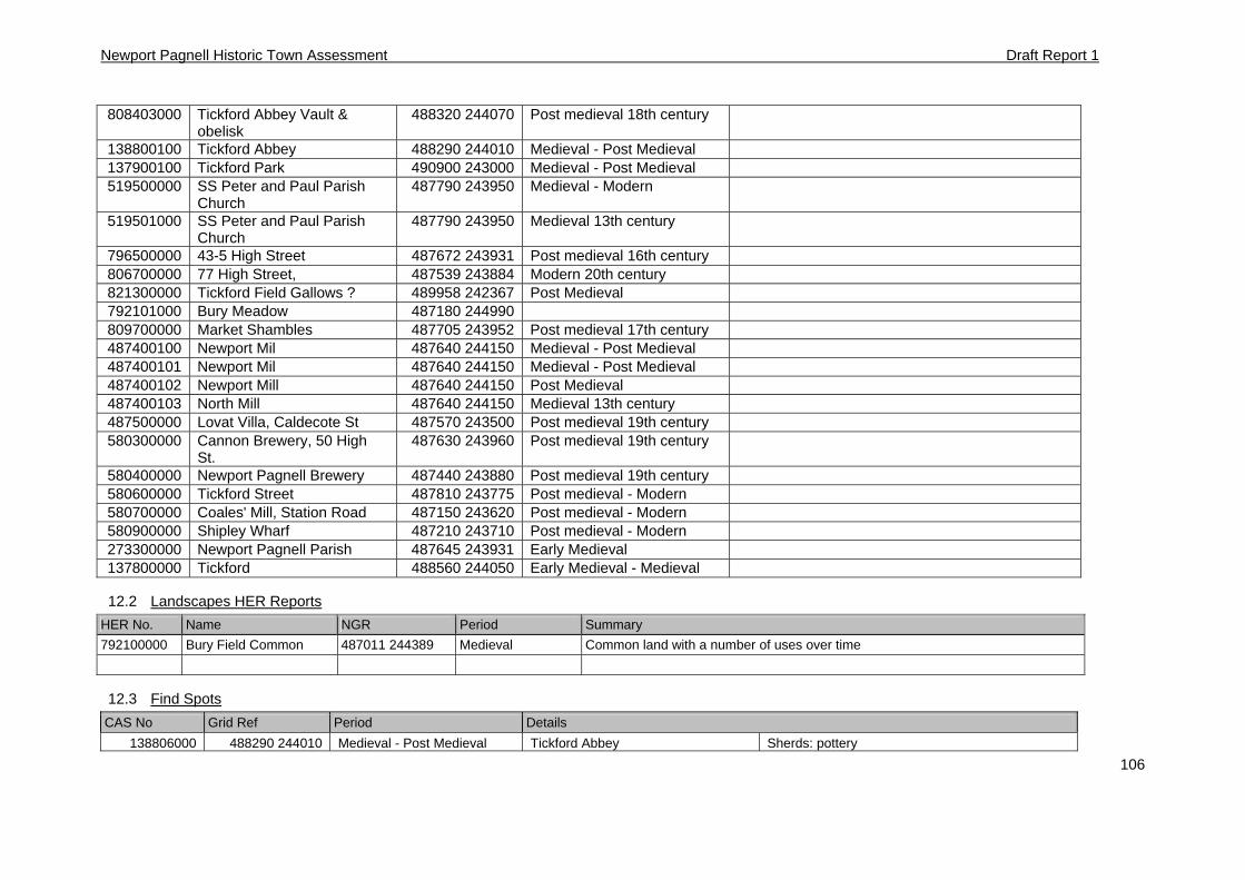
Newport Pagnell Historic Town Assessment Draft Report 1
106
808403000 Tickford Abbey Vault & obelisk
488320 244070 Post medieval 18th century
138800100 Tickford Abbey 488290 244010 Medieval - Post Medieval 137900100 Tickford Park 490900 243000 Medieval - Post Medieval 519500000 SS Peter and Paul Parish
Church 487790 243950 Medieval - Modern
519501000 SS Peter and Paul Parish Church
487790 243950 Medieval 13th century
796500000 43-5 High Street 487672 243931 Post medieval 16th century 806700000 77 High Street, 487539 243884 Modern 20th century 821300000 Tickford Field Gallows ? 489958 242367 Post Medieval 792101000 Bury Meadow 487180 244990 809700000 Market Shambles 487705 243952 Post medieval 17th century 487400100 Newport Mil 487640 244150 Medieval - Post Medieval 487400101 Newport Mil 487640 244150 Medieval - Post Medieval 487400102 Newport Mill 487640 244150 Post Medieval 487400103 North Mill 487640 244150 Medieval 13th century 487500000 Lovat Villa, Caldecote St 487570 243500 Post medieval 19th century 580300000 Cannon Brewery, 50 High
St. 487630 243960 Post medieval 19th century
580400000 Newport Pagnell Brewery 487440 243880 Post medieval 19th century 580600000 Tickford Street 487810 243775 Post medieval - Modern 580700000 Coales' Mill, Station Road 487150 243620 Post medieval - Modern 580900000 Shipley Wharf 487210 243710 Post medieval - Modern 273300000 Newport Pagnell Parish 487645 243931 Early Medieval 137800000 Tickford 488560 244050 Early Medieval - Medieval
12.2 Landscapes HER Reports
HER No. Name NGR Period Summary
792100000 Bury Field Common 487011 244389 Medieval Common land with a number of uses over time
12.3 Find Spots
CAS No Grid Ref Period Details
138806000 488290 244010 Medieval - Post Medieval Tickford Abbey Sherds: pottery
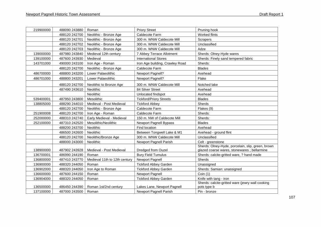
Newport Pagnell Historic Town Assessment Draft Report 1
107
219900000 488090 243880 Roman Priory Street Pruning hook 488120 242700 Neolithic - Bronze Age Caldecote Farm Worked flints 488120 242701 Neolithic - Bronze Age 300 m. WNW Caldecote Mill Scrapers 488120 242702 Neolithic - Bronze Age 300 m. WNW Caldecote Mill Unclassified 488120 242703 Neolithic - Bronze Age 300 m. WNW Caldecote Mill Adze
139000000 487980 243840 Medieval 12th century 7 Abbey Terrace Allotment Sherds: Olney-Hyde wares 139100000 487600 243930 Medieval International Stores Sherds: Finely sand tempered fabric 143701000 490000 243100 Iron Age - Roman Iron Age building, Crawley Road Sherds:
488120 242700 Neolithic - Bronze Age Caldecote Farm Blades
486700000 488800 243200 Lower Palaeolithic Newport Pagnell? Axehead
486701000 488800 243201 Lower Palaeolithic Newport Pagnell? Flake
488120 242700 Neolithic to Bronze Age 300 m. WNW Caldecote Mill Notched lake 487490 243610 Neolithic 84 Silver Street Axehead Neolithic Unlocated findspot Axehead
539400001 487950 243800 Mesolithic Tickford/Priory Streets Blades 138805000 488290 244010 Medieval - Post Medieval Tickford Abbey Sherds
488120 242700 Neolithic - Bronze Age Caldecote Farm Flakes (9) 251900008 488120 242700 Iron Age - Roman Caldecote Farm Sherds: 252000000 488310 242740 Early Medieval - Medieval 150 m. NW of Caldecote Mill Sherds: 252100000 487310 242520 Mesolithic/Neolithic Newport Pagnell Bypass Blades
488200 243700 Neolithic Find location Axehead 486500 242600 Neolithic Between Tongwell Lake & M1 Axehead - ground flint 488120 242700 Neolithic/Bronze Age 300 m. WNW Caldecote Mill Unclassified 488000 243000 Neolithic Newport Pagnell Parish Celt - greenstone
138900000 487902 243928 Medieval - Post Medieval Dredged from Ouzel Sherds: Olney-Hyde, porcelain, slip, green, brown glazed coarse wares, stonewares ; bellarmine
136700001 486990 244190 Roman Bury Field Tumulus Sherds: calcite-gritted ware, ? hand made 136800000 487410 243770 Medieval 11th to 12th century Newport Pagnell Sherds 136900000 488320 244050 Roman Tickford Abbey Garden Unassigned 136902000 488320 244050 Iron Age to Roman Tickford Abbey Garden Sherds: Samian: unassigned 136600000 487600 244150 Roman Newport Pagnell Coin (1) 136904000 488320 244050 Roman Tickford Abbey Garden Knife with tang - iron
136500000 486450 244390 Roman 1st/2nd century Lakes Lane, Newport Pagnell Sherds: calcite-gritted ware (jewry wall cooking pots type b
137100000 487000 243500 Roman Newport Pagnell Parish Pin - bronze
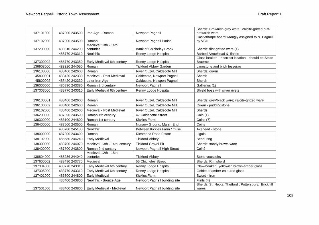
Newport Pagnell Historic Town Assessment Draft Report 1
108
137101000 487000 243500 Iron Age - Roman Newport Pagnell Sherds: Brownish-grey ware; calcite-gritted buff-brownish ware
137102000 487000 243500 Roman Newport Pagnell Parish Castlethorpe hoard wrongly assigned to N. Pagnell by VCH
137200000 488610 244200 Medieval 13th - 14th centuries Bank of Chicheley Brook Sherds: flint-gritted ware (1)
488770 243310 Neolithic Renny Lodge Hospital Barbed Arrowhead & flakes
137300002 488770 243350 Early Medieval 6th century Renny Lodge Hospital Glass beaker - Incorrect location - should be Stoke Bruerne
136903000 488320 244050 Roman Tickford Abbey Garden Limestone and brick tesserae 136100000 488400 242600 Roman River Ouzel, Caldecote Mill Sherds; quern
45800001 488420 242330 Medieval - Post Medieval Caldecote, Newport Pagnell Sherds 45800002 488420 242330 Later Iron Age Caldecote, Newport Pagnell Sherds
136000000 486830 243380 Roman 3rd century Newport Pagnell Gallienus (1)
137303000 488770 243310 Early Medieval 6th century Renny Lodge Hospital Shield boss with silver rivets
136100001 488400 242600 Roman River Ouzel, Caldecote Mill Sherds: grey/black ware; calcite-gritted ware
136100002 488400 242600 Roman River Ouzel, Caldecote Mill Quern - puddingstone
136102000 488400 242600 Medieval - Post Medieval River Ouzel, Caldecote Mill Sherds 136200000 487390 243590 Roman 4th century 47 Caldecotte Street Coin (1) 136300000 486100 244800 Roman 1st century Kickles Farm Coins (7) 136400000 487500 243500 Roman Nursery Ground, Marsh End Coins
486780 245130 Neolithic Between Kickles Farm / Ouse Axehead - stone 138000000 487300 243400 Roman Richmond Road Estate Ligula
138102000 488680 244240 Early Medieval Tickford Abbey Bead; ring
138300000 488700 244070 Medieval 13th - 14th century Tickford Gravel Pit Sherds: sandy brown ware 138400000 487500 243800 Roman 2nd century Newport Pagnell High Street Coin?
138804000 488286 244040 Medieval 12th - 15th centuries Tickford Abbey Stone voussoirs
137600002 488490 243770 Medieval 55 Chicheley Street Sherds: Rim sherd 137304000 488770 243310 Early Medieval 6th century Renny Lodge Hospital Claw-beaker; yellowish brown-amber glass 137305000 488770 243310 Early Medieval 6th century Renny Lodge Hospital Goblet of amber-coloured glass 137401000 486300 244800 Early Medieval Kickles Farm Sword - Iron
488400 243800 Neolithic - Bronze Age Newport Pagnell building site Flints (4)
137501000 488400 243800 Early Medieval - Medieval Newport Pagnell building site Sherds: St. Neots; Thetford ; Potterspury; Brickhill wares
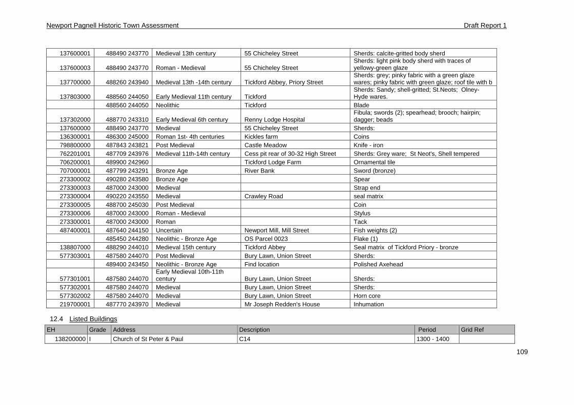
Newport Pagnell Historic Town Assessment Draft Report 1
109
137600001 488490 243770 Medieval 13th century 55 Chicheley Street Sherds: calcite-gritted body sherd
137600003 488490 243770 Roman - Medieval 55 Chicheley Street Sherds: light pink body sherd with traces of yellowy-green glaze
137700000 488260 243940 Medieval 13th -14th century Tickford Abbey, Priory Street Sherds: grey; pinky fabric with a green glaze wares; pinky fabric with green glaze; roof tile with b
137803000 488560 244050 Early Medieval 11th century Tickford Sherds: Sandy; shell-gritted; St.Neots; Olney-Hyde wares.
488560 244050 Neolithic Tickford Blade
137302000 488770 243310 Early Medieval 6th century Renny Lodge Hospital Fibula; swords (2); spearhead; brooch; hairpin; dagger; beads
137600000 488490 243770 Medieval 55 Chicheley Street Sherds: 136300001 486300 245000 Roman 1st- 4th centuries Kickles farm Coins 798800000 487843 243821 Post Medieval Castle Meadow Knife - iron 762201001 487709 243976 Medieval 11th-14th century Cess pit rear of 30-32 High Street Sherds: Grey ware; St Neot's, Shell tempered 706200001 489900 242960 Tickford Lodge Farm Ornamental tile 707000001 487799 243291 Bronze Age River Bank Sword (bronze) 273300002 490280 243580 Bronze Age Spear 273300003 487000 243000 Medieval Strap end 273300004 490220 243550 Medieval Crawley Road seal matrix 273300005 488700 245030 Post Medieval Coin 273300006 487000 243000 Roman - Medieval Stylus 273300001 487000 243000 Roman Tack 487400001 487640 244150 Uncertain Newport Mill, Mill Street Fish weights (2)
485450 244280 Neolithic - Bronze Age OS Parcel 0023 Flake (1) 138807000 488290 244010 Medieval 15th century Tickford Abbey Seal matrix of Tickford Priory - bronze 577303001 487580 244070 Post Medieval Bury Lawn, Union Street Sherds:
489400 243450 Neolithic - Bronze Age Find location Polished Axehead
577301001 487580 244070 Early Medieval 10th-11th century Bury Lawn, Union Street Sherds:
577302001 487580 244070 Medieval Bury Lawn, Union Street Sherds: 577302002 487580 244070 Medieval Bury Lawn, Union Street Horn core 219700001 487770 243970 Medieval Mr Joseph Redden's House Inhumation
12.4 Listed Buildings
EH Grade Address Description Period Grid Ref
138200000 I Church of St Peter & Paul C14 1300 - 1400
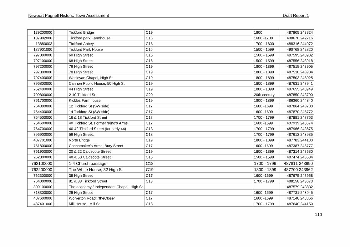
Newport Pagnell Historic Town Assessment Draft Report 1
110
139200000 I Tickford Bridge C19 1800 487805 243824
137902000 II Tickford park Farmhouse C16 1600 -1700 490670 242716
13880003 II Tickford Abbey C18 1700 - 1800 488316 244072
137901000 II Tickford Park House C16 1500 - 1599 490768 242320
797000000 II 60 High Street C16 1500 - 1599 487595 243932
797100000 II 68 High Street C16 1500 - 1599 487556 243918
797200000 II 76 High Street C19 1800 - 1899 487515 243905
797300000 II 78 High Street C19 1800 - 1899 487510 243904
797400000 II Wesleyan Chapel, High St C19 1800 - 1899 487503 243925
796800000 II Cannon Public House, 50 High St C19 1800 - 1899 487631 243941
762400000 II 44 High Street C19 1800 - 1899 487655 243949
709800000 II 2-10 Tickford St C20 20th century 487850 243790
761700000 II Kickles Farmhouse C19 1800 - 1899 486360 244840
764300000 II 12 Tickford St (SW side) C17 1600 -1699 487864 243780
764400000 II 14 Tickford St (SW side) C17 1600 -1699 487870 243772
764500000 II 16 & 18 Tickford Street C18 1700 - 1799 487881 243763
764600000 II 40 Tickford St. Former 'King's Arms' C17 1600 -1699 487939 243674
764700000 II 40-42 Tickford Street (formerly 44) C18 1700 - 1799 487966 243675
796900000 II 56 High Street. C18 1700 - 1799 487612 243935
487701000 II North Bridge C19 1800 - 1899 487783 244130
761800000 II Coachmaker's Arms, Bury Street C17 1600 -1699 487387 243777
761900000 II 20 & 22 Caldecote Street C19 1800 - 1899 487314 243580
762000000 II 48 & 50 Caldecote Street C16 1500 - 1599 487474 243534
762100000 II 1-4 Church passage C18 1700 - 1799 487811 243990
762200000 II The White House, 32 High St C19 1800 - 1899 487700 243962 762300000 II 38 High Street C17 1600 -1699 487675 243958
764000000 II 81 & 83 Tickford Street C18 1700 - 1799 488158 243673
809100000 II The academy / Independent Chapel, High St 487579 243832
818300000 II 29 High Street C17 1600 -1699 487731 243945
487600000 II Wolverton Road: "theClose" C17 1600 -1699 487148 243866
487401000 II Mill House, Mill St C18 1700 - 1799 487640 244150
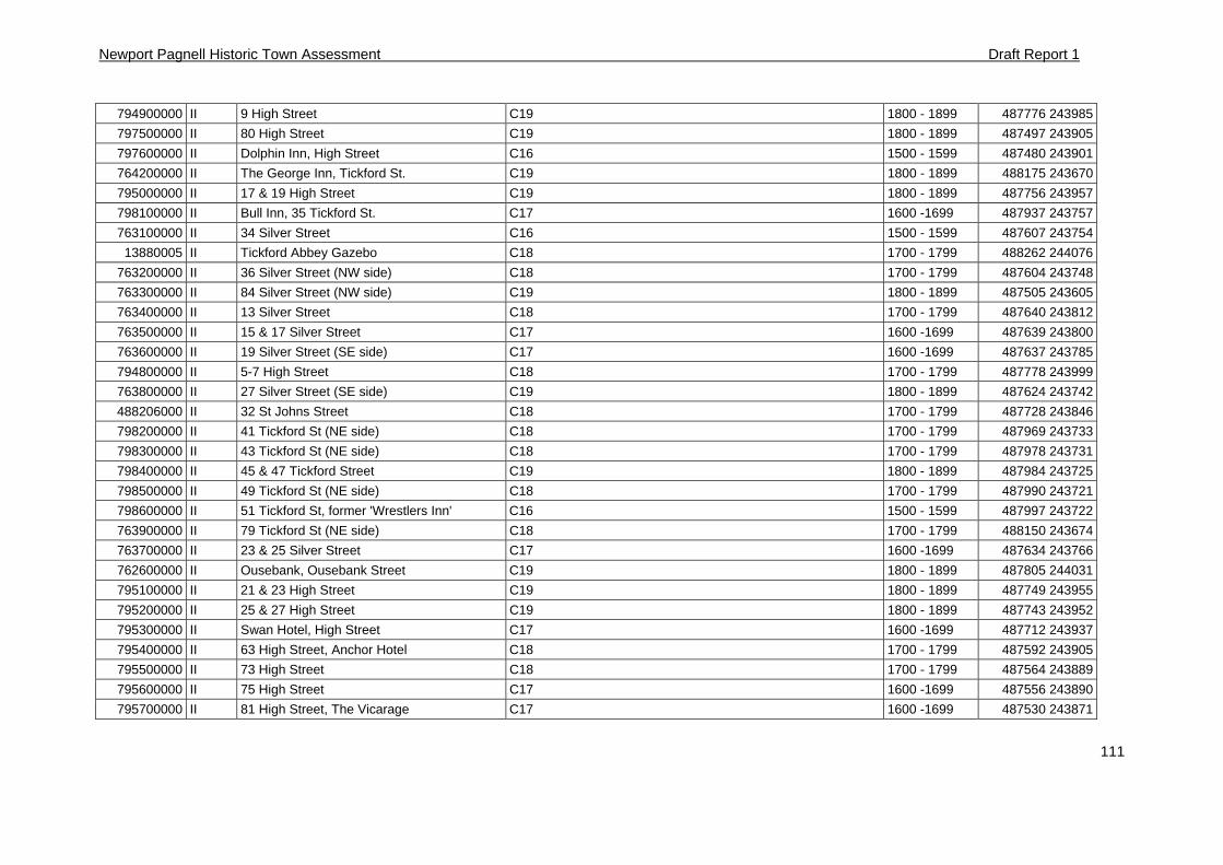
Newport Pagnell Historic Town Assessment Draft Report 1
111
794900000 II 9 High Street C19 1800 - 1899 487776 243985
797500000 II 80 High Street C19 1800 - 1899 487497 243905
797600000 II Dolphin Inn, High Street C16 1500 - 1599 487480 243901
764200000 II The George Inn, Tickford St. C19 1800 - 1899 488175 243670
795000000 II 17 & 19 High Street C19 1800 - 1899 487756 243957
798100000 II Bull Inn, 35 Tickford St. C17 1600 -1699 487937 243757
763100000 II 34 Silver Street C16 1500 - 1599 487607 243754
13880005 II Tickford Abbey Gazebo C18 1700 - 1799 488262 244076
763200000 II 36 Silver Street (NW side) C18 1700 - 1799 487604 243748
763300000 II 84 Silver Street (NW side) C19 1800 - 1899 487505 243605
763400000 II 13 Silver Street C18 1700 - 1799 487640 243812
763500000 II 15 & 17 Silver Street C17 1600 -1699 487639 243800
763600000 II 19 Silver Street (SE side) C17 1600 -1699 487637 243785
794800000 II 5-7 High Street C18 1700 - 1799 487778 243999
763800000 II 27 Silver Street (SE side) C19 1800 - 1899 487624 243742
488206000 II 32 St Johns Street C18 1700 - 1799 487728 243846
798200000 II 41 Tickford St (NE side) C18 1700 - 1799 487969 243733
798300000 II 43 Tickford St (NE side) C18 1700 - 1799 487978 243731
798400000 II 45 & 47 Tickford Street C19 1800 - 1899 487984 243725
798500000 II 49 Tickford St (NE side) C18 1700 - 1799 487990 243721
798600000 II 51 Tickford St, former 'Wrestlers Inn' C16 1500 - 1599 487997 243722
763900000 II 79 Tickford St (NE side) C18 1700 - 1799 488150 243674
763700000 II 23 & 25 Silver Street C17 1600 -1699 487634 243766
762600000 II Ousebank, Ousebank Street C19 1800 - 1899 487805 244031
795100000 II 21 & 23 High Street C19 1800 - 1899 487749 243955
795200000 II 25 & 27 High Street C19 1800 - 1899 487743 243952
795300000 II Swan Hotel, High Street C17 1600 -1699 487712 243937
795400000 II 63 High Street, Anchor Hotel C18 1700 - 1799 487592 243905
795500000 II 73 High Street C18 1700 - 1799 487564 243889
795600000 II 75 High Street C17 1600 -1699 487556 243890
795700000 II 81 High Street, The Vicarage C17 1600 -1699 487530 243871
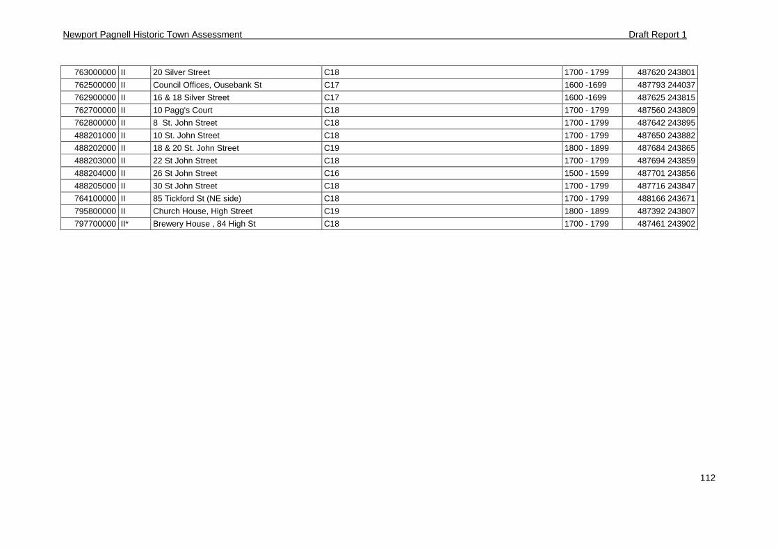
Newport Pagnell Historic Town Assessment Draft Report 1
112
763000000 II 20 Silver Street C18 1700 - 1799 487620 243801
762500000 II Council Offices, Ousebank St C17 1600 -1699 487793 244037
762900000 II 16 & 18 Silver Street C17 1600 -1699 487625 243815
762700000 II 10 Pagg's Court C18 1700 - 1799 487560 243809
762800000 II 8 St. John Street C18 1700 - 1799 487642 243895
488201000 II 10 St. John Street C18 1700 - 1799 487650 243882
488202000 II 18 & 20 St. John Street C19 1800 - 1899 487684 243865
488203000 II 22 St John Street C18 1700 - 1799 487694 243859
488204000 II 26 St John Street C16 1500 - 1599 487701 243856
488205000 II 30 St John Street C18 1700 - 1799 487716 243847
764100000 II 85 Tickford St (NE side) C18 1700 - 1799 488166 243671
795800000 II Church House, High Street C19 1800 - 1899 487392 243807
797700000 II* Brewery House , 84 High St C18 1700 - 1799 487461 243902
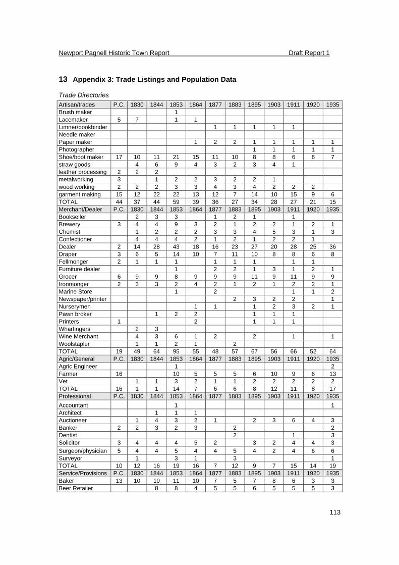
Newport Pagnell Historic Town Report Draft Report 1
113
13 Appendix 3: Trade Listings and Population Data
Trade Directories
Artisan/trades P.C. 1830 1844 1853 1864 1877 1883 1895 1903 1911 1920 1935Brush maker 1 Lacemaker 5 7 1 1 Limner/bookbinder 1 1 1 1 1 Needle maker Paper maker 1 2 2 1 1 1 1 1 Photographer 1 1 1 1 1 Shoe/boot maker 17 10 11 21 15 11 10 8 8 6 8 7 straw goods 4 6 9 4 3 2 3 4 1 leather processing 2 2 2 metalworking 3 1 2 2 3 2 2 1 wood working 2 2 2 3 3 4 3 4 2 2 2 garment making 15 12 22 22 13 12 7 14 10 15 9 6 TOTAL 44 37 44 59 39 36 27 34 28 27 21 15 Merchant/Dealer P.C. 1830 1844 1853 1864 1877 1883 1895 1903 1911 1920 1935Bookseller 2 3 3 1 2 1 1 Brewery 3 4 4 9 3 2 1 2 2 1 2 1 Chemist 1 2 2 2 3 3 4 5 3 1 3 Confectioner 4 4 4 2 1 2 1 2 2 1 Dealer 2 14 28 43 18 16 23 27 20 28 25 36 Draper 3 6 5 14 10 7 11 10 8 8 6 8 Fellmonger 2 1 1 1 1 1 1 1 1 Furniture dealer 1 2 2 1 3 1 2 1 Grocer 6 9 9 8 9 9 9 11 9 11 9 9 Ironmonger 2 3 3 2 4 2 1 2 1 2 2 1 Marine Store 1 2 1 1 2 Newspaper/printer 2 3 2 2 1 Nurserymen 1 1 1 2 3 2 1 Pawn broker 1 2 2 1 1 1 Printers 1 2 1 1 1 Wharfingers 2 3 Wine Merchant 4 3 6 1 2 2 1 1 Woolstapler 1 1 2 1 2 TOTAL 19 49 64 95 55 48 57 67 56 66 52 64 Agric/General P.C. 1830 1844 1853 1864 1877 1883 1895 1903 1911 1920 1935Agric Engineer 1 2 Farmer 16 10 5 5 5 6 10 9 6 13 Vet 1 1 3 2 1 1 2 2 2 2 2 TOTAL 16 1 1 14 7 6 6 8 12 11 8 17 Professional P.C. 1830 1844 1853 1864 1877 1883 1895 1903 1911 1920 1935
Accountant 1 1 Architect 1 1 1 Auctioneer 1 4 3 2 1 2 3 6 4 3 Banker 2 2 3 2 3 2 2 Dentist 2 1 3 Solicitor 3 4 4 4 5 2 3 2 4 4 3 Surgeon/physician 5 4 4 5 4 4 5 4 2 4 6 6 Surveyor 1 3 1 3 1 TOTAL 10 12 16 19 16 7 12 9 7 15 14 19 Service/Provisions P.C. 1830 1844 1853 1864 1877 1883 1895 1903 1911 1920 1935Baker 13 10 10 11 10 7 5 7 8 6 3 3 Beer Retailer 8 8 4 5 5 6 5 5 5 3
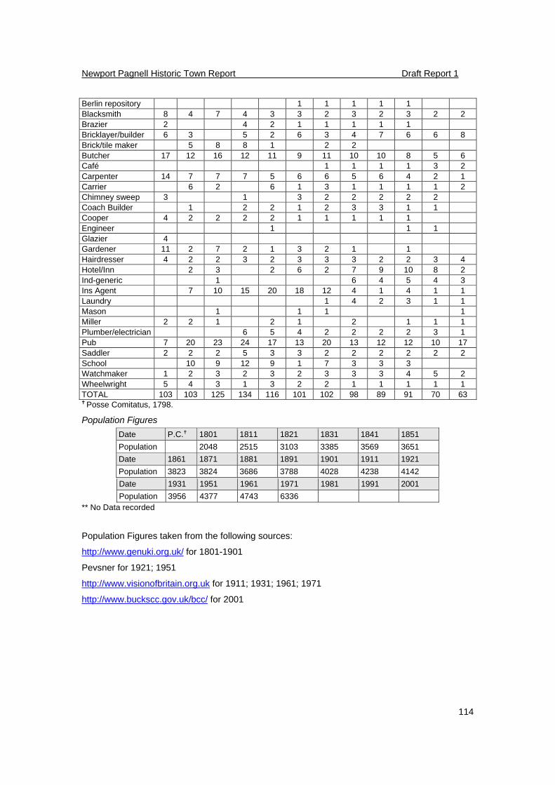
Newport Pagnell Historic Town Report Draft Report 1
114
Berlin repository 1 1 1 1 1 Blacksmith 8 4 7 4 3 3 2 3 2 3 2 2 Brazier 2 4 2 1 1 1 1 1 Bricklayer/builder 6 3 5 2 6 3 4 7 6 6 8 Brick/tile maker 5 8 8 1 2 2 Butcher 17 12 16 12 11 9 11 10 10 8 5 6 Café 1 1 1 1 3 2 Carpenter 14 7 7 7 5 6 6 5 6 4 2 1 Carrier 6 2 6 1 3 1 1 1 1 2 Chimney sweep 3 1 3 2 2 2 2 2 Coach Builder 1 2 2 1 2 3 3 1 1 Cooper 4 2 2 2 2 1 1 1 1 1 Engineer 1 1 1 Glazier 4 Gardener 11 2 7 2 1 3 2 1 1 Hairdresser 4 2 2 3 2 3 3 3 2 2 3 4 Hotel/Inn 2 3 2 6 2 7 9 10 8 2 Ind-generic 1 6 4 5 4 3 Ins Agent 7 10 15 20 18 12 4 1 4 1 1 Laundry 1 4 2 3 1 1 Mason 1 1 1 1 Miller 2 2 1 2 1 2 1 1 1 Plumber/electrician 6 5 4 2 2 2 2 3 1 Pub 7 20 23 24 17 13 20 13 12 12 10 17 Saddler 2 2 2 5 3 3 2 2 2 2 2 2 School 10 9 12 9 1 7 3 3 3 Watchmaker 1 2 3 2 3 2 3 3 3 4 5 2 Wheelwright 5 4 3 1 3 2 2 1 1 1 1 1 TOTAL 103 103 125 134 116 101 102 98 89 91 70 63 Posse Comitatus, 1798.
Population Figures
Date P.C. 1801 1811 1821 1831 1841 1851
Population 2048 2515 3103 3385 3569 3651
Date 1861 1871 1881 1891 1901 1911 1921
Population 3823 3824 3686 3788 4028 4238 4142
Date 1931 1951 1961 1971 1981 1991 2001
Population 3956 4377 4743 6336 ** No Data recorded
Population Figures taken from the following sources:
http://www.genuki.org.uk/ for 1801-1901
Pevsner for 1921; 1951
http://www.visionofbritain.org.uk for 1911; 1931; 1961; 1971
http://www.buckscc.gov.uk/bcc/ for 2001
Newport Pagnell Historic Town Report Draft Report 1
115
14 Appendix 4: Historical Consultancy Report
Produced by Kim Taylor-Moore of the University of Leicester
Background
The entry for Newport Pagnell in Domesday Book includes no mention of a market or tolls but its name clearly implies that it was a trading centre, or port, and there was almost certainly a mint there in the eleventh century and possibly as early as the tenth.i In Domesday Book it was assessed at five hides but its population is difficult to ascertain since, in addition to the five villeins and nine slaves enumerated, the presence of ‘other men who work outside the five hides’, ‘ men who live in the woodland’ and an unknown number of burgesses were also recorded. Buckingham apart, Newport was the only place in the county where burgesses were explicitly mentioned but its value, both before and after 1066 ( £24 and £20 respectively), was only about half of that of other places showing early signs of urbanisation such as Aylesbury, Wendover and Brill. Unlike these places, Newport was not royal demesne, the manor being held by William fitz Ansculf, who also held the neighbouring manor of Tickford and part of the vill of Caldecote, both of which later became part of the ecclesiastical and civil parish of Newport Pagnell.ii William fitz Ansculf held lands in other parts of the county, assessed at over 100 hides in total, all of which became part of the honour of Newport. By the beginning of the twelfth century the manor and honour had passed to Fulk Paynel, possibly William’s son-in-law, and both became part of his barony of Dudley. They remained in the Paynel family, from whom the town takes its name, passing via the female line to Ralph de Somery by 1207. The Paynel family were responsible for the founding of Tickford Priory, a cell of the Cluniac Abbey of Marmoutier, in the early twelfth century, and almost certainly built the castle which was known to have existed in the town. By 1240 there were two hospitals: the hospital of St John the Baptist and St John the Evangelist, located near to Tickford Bridge, and the leper hospital dedicated to St Margaret which lay ‘without Newport Pagnell’ - probably in the neighbouring parish of Lathbury.iii In the fourteenth century the manor and honour passed through several collateral lines of the de Somery family until, in 1435, it was inherited by James Ormond, earl of Ormond and Wiltshire. The manor changed hands several times during the Wars of the Roses but in 1485 Thomas Ormond, brother of James, regained possession and in 1542 his descendants granted Newport to the Crown in exchange for lands in Devon.iv Newport was free from suit at the county and hundred courts and the lord had his own pillory, tumbril and gallows. In 1245 there were fifty-three burgage tenements recorded in the town but there were few signs of corporate life, the borough merely being regarded as the urban part of the manor, its physical extent marked by four boundary stones. The borough court, known as the unbodmot, the portmote, and the market, which had been granted by charter in 1270 but which had certainly been in existence by 1187, when the monks at Tickford Priory were granted freedom from market tolls, were all in the lord’s hands. There seems to have been some development towards self-governance by 1380, however, when a grant of pontage was made to four named principal inhabitants of the town and the guild of St Mary had been formed before 1483. The guild met in the Saracen’s Head which had been granted to them ‘for the maintenance of the bridges, amendment of the highways and the relief of the poor’ and acquired other property which became part of the charitable foundation known as ‘Town Lands’. By 1479 it is clear that a bailiff, elected at the unbodmot, was acting as a representative of the townsmen in dealings with the lord and was farming the tolls of the market and fair.v Once in royal hands, the manor of Newport Pagnell was attached to the honour of Ampthill and leased out. In the early years of the seventeenth century the lessees, keen to maximise income, began to claim all the profits arising from the market and fair and to ignore the ‘right’ of the townsmen to elect their own bailiff to farm the same. A series of disputes followed in which the lords of the manor, although admitting that such a custom had arisen, questioned its validity as the townsmen had no charters to show. In 1632 the burgesses brought an action of trespass against the lord but before its conclusion they admitted defeat and ended their claim to corporate privileges. As a result the bailiff became an appointee of the lord and soon afterwards the borough courts seem to have ceased to function.vi
Newport Pagnell Historic Town Report Draft Report 1
116
In 1627 Newport Pagnell was sold to Sir Francis Annesley, a native of the town, whose descendants, the earls of Anglesey, held it until 1810.vii The position of Newport Pagnell on the main route from London to the east midlands, which had always been an important source of trade, led to it being occupied by both sides in the Civil War. The royalists began building fortifications in 1643 but retreated within a few months, to be replaced by the parliamentarians who based a garrison there, raising money from the eastern counties to pay for the fortifications and provisions. The garrison was disbanded in 1645 but a plan of 1644 showing the earthworks includes a basic map of the town and shows some of the buildings in High Street.viii In the eighteenth century Newport Pagnell continued to benefit from its position, becoming an important stopping place for coaches to the east midlands and the north including the regular London to Northampton coach. In its heyday thirty-three four-horse coaches passed through the town daily, but the trade had largely ceased by about 1840. A canal linking Newport Pagnell to the Grand Junction Canal at Great Linford opened in 1817 but was never very profitable, probably due to the six locks necessary on the stretch. In 1864 the canal was bought by the newly formed Newport Pagnell Railway Company, who closed it and built part of the railway to Wolverton over its route.ix The most important trade to the economy of the town, however, was lace. Lace traders were recorded in the town as early as 1611 and it quickly developed into the local centre for the industry. A lace market was held every Wednesday but great quantities were sold at the fairs and, later, much was exported to America. In the eighteenth century at least forty-five lace dealers were active in the town and the number of outworkers in the area must have been very high. The census taken in 1851, after the trade had suffered great decline, still records 316 lacemakers in Newport Pagnell.x
Medieval Records (to 1500)
Manorial records Newport Pagnell Extent (copy), 1272: CBS D/B 143 Account, with other manors, 1401-2: ERO D/DVo 13 Bailiff’s account roll, 1443-4: NRO FH 454 Minister’s accounts, with other manors, 1478-80: TNA:PRO DL29/643/10346 (translated and printed in F.W. Bull, A History of Newport Pagnell (Kettering, 1900), pp. 198-201) Minister’s accounts, with other manors, 1481-3: TNA:PRO DL29/643/10438 Tickford Survey, with other manors, 1272-3: TNA:PRO LR2/188 (f 115) Tickford Priory accounts, 1442-3: EC 46/359 Rental, lands in Chicheley and Little Crawley, 1481: CBS D/C 2/1 Court roll – view of frankpledge, 1400-1: CBS D/BASM 55/1 Court roll – view of frankpledge, 1407: CBS D/BASM 55/2 Caldecote View of frankpledge, 1310: BL Add Ch 11224 Hundred Rolls Entries for Newport are included in: Rotuli Hundredorum, 2 vols Record Commission (London,
1812), vol i, pp. 28-9, 40, 47; vol ii, p. 350. (The more useful part of the 1279-80 roll does not survive for the town).
Tax Records Assessments for Newport Pagnell generally include the settlements which had grown up at
Tickford, to the east of the town and at Marsh End to the south-west of the town as well as the borough itself. Caldecote is included with neighbouring Willen, rather than Newport. Containing assessments on named individuals Twentieth, 1327: TNA:PRO E179/242/4 (printed in A.C. Chibnall, Early Taxation Returns.
Newport Pagnell Historic Town Report Draft Report 1
117
Taxation of Personal Property in 1332 and later, BRS, 14(1966), pp. 94-5) Fifteenth and tenth, 1332: TNA:PRO E179/378/15 (damaged but is a duplicate of above) Two ninths and fifteenths and tax on wool, 1340 - TNA:PRO E179/77/9 rot 4 (including the chapelry of Little Linford) Containing communal assessments only Fifteenth and tenths: 1334: TNA:PRO E179/378/24 1336: TNA:PRO E179/378/27 1336: TNA:PRO E179/77/4 1337: TNA:PRO E179/77/6 & 7 1344: TNA:PRO E179/77/13 1346: TNA:PRO E179/77/14 & 15 1348: TNA:PRO E179/77/16 & 17 1352: TNA:PRO E179/77/18-21 1380: TNA:PRO E179/77/25 1388: TNA:PRO E179/77/27 1393: TNA:PRO E179/77/28 & 29 1395: TNA:PRO E179/77/30 1398: TNA:PRO E179/77/31 1431: TNA:PRO E179/77/52 1446 schedule of reductions: TNA:PRO E179/77/65 1449 schedule of reductions: TNA:PRO E179/77/66 (Assessments for 1332, 1336 and 1446 are included in: A.C. Chibnall, Early Taxation Returns. Taxation of Personal Property in 1332and later, BRS, 14 (1966), pp. 94-5, 100) Other Before 1220 carucage: TNA:PRO E179/239/241 1340 Levy of wool: TNA:PRO E179/77/8 & 11 Ecclesiastical records Probate Apart from wills proved in the PCC, which are not considered here, Newport Pagnell wills are to
be found amongst those proved in the courts of the archdeaconry of Buckingham and all existing from before 1660 are indexed in:
J. Hunt, R. Bettridge & A. Toplis, Index to Probate Records of the Archdeaconry Court of Buckingham 1483-1660 and of the Buckinghamshire Peculiars 1420-1660, BRS 32 (2001)
Two wills from 1496 and 1506 are included in F.W. Bull, A History of Newport Pagnell (Kettering, 1900), pp. 209-11.
Other records of the archdeaconry of Buckingham Miscellaneous registers 1483-1523: CBS D-A/We/1 (included in: E.M. Elvey (ed.), The Courts of the Archdeaconry of Buckingham 1483-1523, BRS, 19 (1975)) Visitation books, 1492-1788: CBS D-A/V Other Newport Pagnell records (not an exhaustive list) Survey of borough, 1245: Ch IPM, 29 Henry III no. 50 Charter granting market and fair, 1270: CChR, 1257–1300, p. 131 Deeds relating to 13th C (after 1291): BL Add. Ch. 56419-20 Quitclaim from John de Somery to St John’s Hospital, 1315-6: TNA:PRO C 148/62 Charter granting fair, 1327: CChR, 1327–41, p. 12 Transcript of charters and other evidences relative to the manors of Risborough and Newport Pagnell, 1344: TNA:PRO E 163/4/50
Newport Pagnell Historic Town Report Draft Report 1
118
Grant of a messuage in Tickford, paying yearly towards the lamp of St Peter in the chancel of Newport Pagnell, 1349: TNA:PRO E 40/179 Deeds relating to Newport Pagnell (and many other manors), 1356-1761: TNA:PRO C 103/39/2 Deed relating to messuage and 10 acres, 1365: CBS D/P 67 Grant of pontage, 1380: CPR, 1377-81, p.562 Grant of pontage, 1394: CPR, 1391-6, p. 372 Release of right in one third of the manor of Newport Pagnell, 1418-9: TNA:PRO E 210/3149 Conveyance of the third part of the manor of Newport Pagnell, 1408-9: TNA:PRO E 327/384 Deeds, 1448, 1473: BL Add. Ch. 72130; Eg. Ch. 2415-6 Release of right in manor of Newport Pagnell, 1493-4: TNA:PRO E 327/721 Early Modern Records (1500-1800) Manorial records Newport Pagnell Court roll (honour of Ampthill), 1509-47: TNA:PRO SC 2/153/1 Survey, with other manors, 1541: CBS D/BASM 55A/1 Survey of manor, with members, 1541-2: CBS D/U 2/18-9 Ministers accounts (honour of Ampthill), 1542-4: TNA:PRO SC 6/HENVIII/6070 Account roll, 1543-4: CBS AR 94/1980 Box 34/9/20 Court rolls (foreign courts, curiae portis and curiae umbodmote), 1544-7: TNA:PRO SC 2/155/20 Court rolls, Henry VIII?: TNA:PRO SC 2/155/21 Survey of boundaries of manor, 1608: CBS D/C 2/13 Survey, 1608: CBS: D/X 113/2/1; TNA:PRO LR 2/197 ff 273-7; LR 2/198 ff 143-6; LR 2/210 ff 288-401 (extracts printed in F.W. Bull, A History of Newport Pagnell (Kettering, 1900), pp. 49-53) Extracts from court roll, 1674: CBS D/B 135 Rent roll, 1692-9: CBS D/BASM 55A/2 Accounts of arrears (2), 1705-7: CBS D/BASM 55A/3-4 Quit rent accounts used in rent dispute, 1707-10: CBS D/B 136/1-2 Steward’s accounts with related papers used in rent dispute, 1721-30: CBS D/B 136/3-12 Account books of quit rents, 1759-99: CBS D/B 126-7 Rent books (2), 1760-1810: CBS D/B 128-9 Tickford Account roll: ‘Receipts to the house of Tykford’, before 1524: CBS D/BASM 55/14 Valuation of lands of the manor, 1531: CBS D/C 1/309 Survey, with other manors, 1541: CBS D/BASM 55A/1 Valuation of rents, with Chicheley, 1544: CBS D/C 2/2 Survey, with Newport Pagnell, 1608: TNA:PRO LR 2/210 ff 288-401 Presentments of jury, 1708: CBS D/BASM 55/18 Extracts from court rolls, 1739-1801 (non consec.): CBS D/BASM 55/19 Account of profits of court, 1790: CBS D/BASM 55/15 Court rolls, 1739, 1769, 1783, 1790,1794: CBS D/BASM 55/3-7 Minutes of court with suit roll, quit rents, and bill for food and drink at court, 1783: CBS D/BASM 55/8/1-2 Minutes of court with suit roll and quit rents, 1790: CBS D/BASM 55/9/1-2 Court roll (draft) with suit roll: CBS D/BASM 55/10 Caldecote
Newport Pagnell Historic Town Report Draft Report 1
119
Particular of manor, 17th C: CBS D/BASM 55B/1 Rental, 18th C: CBS D/BASM 55B/2 Query regarding revival of courts (lapsed for 100 years) with schedule of court rolls, 18th C: CBS D/BASM 55B/3 Tax records Hearth tax Three documents survive for Newport Pagnell relating to the 1662 tax: TNA/PRO E
179/80/349,351; 179/367/1 Part 2. A copy of the first document only is available on microfilm at CBS.
Ship money 1635: TNA:PRO E 179/244/1A & 2, E 179/273/5, E 179/275/2 Lay subsidies with records including names 1523: TNA:PRO E 179/78/92 (Marsh End and Tickford assessed separately) 1523: TNA:PRO E 179/78/99 (Marsh End and Tickford assessed separately) - (included in: A.C. Chibnall, Subsidy Roll for the County of Buckingham Anno 1524, BRS, 8 (1950), pp. 80-1) 1540: TNA:PRO E 179/78/156 1542: TNA:PRO E 179/78/124 1543: TNA:PRO E 179/78/159 1545: TNA:PRO E 179/78/140, 151-2 1549: TNA:PRO E 179/78/163-5 1549: Certificates of residence relating to subsidy: TNA:PRO E 179/69/70 1593: TNA:PRO E 179/79/220 1597: TNA:PRO E 179/79/234, 239 & 241 1606: TNA:PRO E 179/79/258 1610: TNA:PRO E 179/79/268 1621: TNA:PRO E 179/79/269 1624: TNA:PRO E 179/79/281 1628: TNA:PRO E 179/80/290 & 293 1641: TNA:PRO E 179/79/283 1663: TNA:PRO E 179/79/267 Part 6 Assessments where no names are recorded have not been included but can be found in TNA
‘E179 database’ at http://www.nationalarchives.gov.uk/e179 Parish records Registers Baptisms, 1558-1895; marriages, 1558-1967; burials, 1558-1964: CBS PR 153/1/1- 24 (An analysis of the occupations of those married at Newport Pagnell 1754-1800 is included in: D.
Mynard and J. Hunt, Newport Pagnell. A Pictorial History (Chichester, 1995), pp. xvii-xviii) Other Glebe terriers and inventory, 1601,1707, 1782: CBS PR 153/3/1 Deeds of messuage next to churchyard, 1758-1811: CBS PR 153/3/9 Draft churchwardens’ accounts, 1676: CBS PR 153/5/1 (translated and printed in F.W. Bull, A History of Newport Pagnell (Kettering, 1900), pp. 127-8) Removal orders, 1700-1815: CBS PR 153/13/209-315 Settlement certificates and examinations, 1672-1823: CBS PR 153/13/1-376 Apprenticeship indentures, 1712-1862: CBS PR 153/14/1-86 Bastardy papers, 1718-1783: CBS PR 153/15/1-14 Contract for farming the poor, 1739: CBS PR 153/16/1
Newport Pagnell Historic Town Report Draft Report 1
120
Charities – deeds and papers, 1596-1895: CBS PR 153/25/1-34 Quietus for debt re purchase of woods in Salcey Forest, 1643: CBS PR 153/28/1 Agreement re inclosure of the Common Pightell and building of brick kiln, 1687: CBS PR 153/28/2 Ecclesiastical records and returns of religion Probate Apart from wills proved in the PCC, which are not considered here, Newport Pagnell wills, post
1500, are to be found amongst those proved in the courts of the archdeaconry of Buckingham and all existing from before 1660 are indexed in:
J. Hunt, R. Bettridge & A. Toplis, Index to Probate Records of the Archdeaconry Court of Buckingham 1483-1660 and of the Buckinghamshire Peculiars 1420-1660, BRS 32 (2001)
For later periods indexes to probate records of the archdeaconry court of Buckingham are available at the CBS.
Other records of the archdeaconry of Buckingham Miscellaneous registers 1483-1523: CBS D-A/We/1 (included in: E.M. Elvey (ed.), The Courts of the Archdeaconry of Buckingham 1483-1523, BRS, 19 (1975) Visitation books, 1492-1788: CBS D-A/V (see also: E.R.C. Brinkworth (ed.), Episcopal Visitation Book for the Archdeaconry of Buckingham, 1662, BRS, 7 (1947)) Act Books of the Court of the Commissary of Buckingham, 1521-1836: CBS D-A/C/1-22 Misc items including churchwardens and some probate inventories, 1542-1851: CBS D-A/X Depositions of witnesses and defendants, 1578-1687: CBS D-A/C/23-4 Miscellaneous court papers, 1600-38: CBS D-A/C/25-28 Fee books and accounts, 1717-1863: CBS D-A/Fm/1-10 Other records relating to the parish Details of parish populations, number of dissenters etc can be found in various religious returns
and censuses. Entries for Buckinghamshire parishes appear in the following publications: A. Dyer and D.M. Palliser (eds.), The Diocesan Population Returns for 1563 and 1603, Records of Social and Economic History, N.S. 31 (2005) pp. 234-44; 359-67 A. Whiteman (ed.), The Compton Census of 1676 : a Critical Edition, Records of Social and Economic History, NS 10 (1986), p. 365-71 C.W. Foster, The State of the Church, Lincoln Record Society, 23 (1926), pp 443-6 J. Cornwall, An Elizabethan Census, BRS, 16 pt 4 (1959), pp 258-73 Military surveys, musters and other population listings Certificate of musters, 1522: A.C. Chibnall (ed.), The Certificate of Musters for Buckinghamshire in 1522, BRS, 17 (1973), pp 298-301 Muster roll, 1535: TNA:PRO E 101/58/16 and see R.T. Baldwin, The Certificate of Musters for Buckinghamshire, 1535 (unpub. transcript, PRO Library, 1989) Collection in aid of protestants in Ireland, 1642: J. Wilson, Buckinghamshire Contributions for Ireland 1642 and Richard Grenville’s Military Accounts 1642-1645, BRS, 21 (1983) Buckinghamshire Posse Comitatus 1798: CBS L/P/15&16 (printed in I.F.W. Beckett, The Buckinghamshire Posse Comitatus 1798, BRS,22 (1985)) Title Deeds Bull Deeds Over 200 pre 1800 deeds for properties in the town are included in the papers deposited by Bull,
Astley and Harding (CBS D/B) and transcriptions of all, by D.C. Mynard, are available on cd. Other deeds Deeds, 1624: BL Add. Ch. 46924 Deeds relating to Newport Pagnell (and many other manors), 1356-1761: TNA:PRO C 103/39/2 Various deeds, 17th C – 19th C: CBS DC13/13/3/1-16
Newport Pagnell Historic Town Report Draft Report 1
121
The BAS Collection at CBS also contains many deeds relating to properties in Newport Pagnell, 17th C – 19th C : CBS BAS Coll. See also the card index at CBS.
County records with Newport Pagnell entries For Newport Pagnell entries in the county quarter sessions, 1678-1733 see: W. le Hardy and G.L. Reckitt (eds), County of Buckingham Calendar to the Sessions Records, 1678-1733, 8 vols (Aylesbury, 1933-87). Indexes for later periods are available at CBS. Return of vintners, innholders and alehousekeepers in Bucks (transcript), 1577: CBS, D-X423/1.
(The full list of names can be found on-line, in the A2A catalogue). Other Newport Pagnell records Survey of property of Tickford priory including Newport tithes, freehold rents etc, from reign of Henry VIII, printed in G. Lipscomb, The History and Antiquities of the County of Buckingham, vol. 4 (London, 1847), pp. 294-6 Extracts from the register of Newport Pagnell Abbey, 16th C: BL Sloane 1301 Chancery case regarding shops and a messuage in Newport, 1529-32: TNA:PRO C 1/651/16 View of Account, 1547-52: TNA:PRO E 315/428/3 Commissioners for charitable uses – Newport hospital and ‘divers charities’, 1598-9: TNA:PRO C 93/1/10 Inquisition into copyhold lands of the manor (with other manors), 1599-1600: TNA:PRO E 178/460 Orders of the Court of Exchequer regarding disputes between townsmen and lords, 1615-32:
TNA: PRO E 125/12 f 360 et seq Inquisition as to a concealed mill, 1622-3: TNA:PRO E 178/3595 Papers relating to the parliamentary garrison, 1644-6: BL Add. 61681 ff 55, 89-91b, 111- 114b; Add. 61682 ff 1-150 passim Receipts and accounts for taxes for parliamentary garrison, 1645: BL Add. 40630 ff 172-206 passim Letter-book of Governor of Newport Pagnell, 1645: BL Eg. 3514 Return of writs: ad quod damnum - fair at Newport Pagnell, 1656: TNA:PRO C 202/40/4 Exchequer depositions regarding the Bull Inn, 1707-9: TNA:PRO E 134/6&7Anne/Hil7 A list of eighteenth century Newport Pagnell lace dealers, compiled from PCC wills, fire insurance records and a trade directory is printed in: D. Mynard and J. Hunt, Newport Pagnell. A
Pictorial History (Chichester, 1995), pp. xx-xxi Maps and pictures Plan of Civil War fortifications, 1644: included in Mynard and Hunt, Newport Pagnell, fig. 2, and see www.mkheritage.co.uk/nphs/civmap.html Plan showing course of Tickford Brook and adjoining lands, c1620: CBS D/C/2/18 Tracing of Inclosure Map, Port field, 1795: CBS IR/67 Inclosure map, Tickford field, 1808: CBS IR/67 2 R Map of Tickford Park and farms, 1808: CBS Ma/254/1 Proposed Canal, 1813: CBS P/VA 24 R Drawings of the church, 1819: BL Add. 36359 ff 4-8b Aquatint of Tickford Bridge by J. Hassell from his "Tour of the Grand Junction Canal, 1819" (also shows the old Hospital): CBS DC13/37/78 Trade Directories The Universal British Directory of Trade and Commerce Vol 4 (London, 1798) pp. 65-8 Local Newspapers
Newport Pagnell Historic Town Report Draft Report 1
122
No newspapers were printed in Buckinghamshire until the nineteenth century. The Northampton Mercury, first published in 1720, covered events in Newport Pagnell, such as the election of the Town Crier and watchman in 1784 and the death in 1786 of a ‘breeches maker who practised innoculation and ‘never lost a single patient’.xi
Modern Records (Post 1800) Due to the volume of records existing from this period only those relating to housing by-laws and
the installation of services are recorded in accordance with the ‘Brief for Historical Documentary Research’. A list of useful secondary sources covering the period is also included.
Housing by-laws and similar Newport Pagnell Urban District Council, with nine members, was formed in 1897. It replaced the
parish council, created by the Local Government Act 1894, which ‘had been found wanting’.xii It is not clear who effectively controlled the town prior to this date, so the main records of the likely bodies: the vestry, the Poor Law Board of Guardians, the trustees of the town’s bridges and the committee of the commonholders of Bury Field (one of the former common fields which remained unenclosed into the 20th century)xiii are included below.
Bridge Trustees minute books, toll books etc, 1809-59: CBS DC 13/39/1-11 Newport Pagnell Union Board of Guardians minute books, 1835-1948: Records of Bury Field Common Owners, 1846-1964: CBS DC 13/39/18-31 Newport Pagnell Parish Council minute book, 1894-7: CBS DC 13/39/34 Newport Pagnell Vestry minute book, 1875-1966: CBS PR 153/8/9 Parochial Sanitary Committee minute book, 1890-1897: CBS DC 13/39/32-3 Papers of Newport Pagnell Urban District Council 1897-1974: CBS DC13 (Includes minute books, town planning schemes, papers on development, bye-laws relating to housing, new streets etc, Catalogue at CBS and on www.a2a.org.uk) Installation of services Water In 1787 a water system was installed which supplied 102 houses. The Rural Sanitary Authority
raised a loan of £4000 for the construction of The Ash Hill Water Works, to serve the town, in 1887. They became operational the following year.xiv
Notebook containing a number of notes on the Newport Pagnell water supply, c.1910- 20: CBS DC3/10/74 Ash Hill Water Works: CBS DC13/37/50 Electricity No records have been found relating to the introduction of an electricity supply, other than those
relating to street lighting. Newport Pagnell electric lighting scheme, 1931: CBS DC13/10/81 Gas The Newport Pagnell Gas and Coke Co was formed by deed of co-partnership on 25 Mar 1837
and began supplying gas in 1838 from the works in Marsh End.xv In 1937 the company was taken over by the Northampton Gas Light Co.
Papers of Newport Pagnell Gas and Coke Co: National gas Archive (Transco plc) EM/NEP (copy of deed of partership also at CBS D/B/108) Misc. papers of Newport Pagnell Gas and Coke Co: CBS DC13/17/1-2; DC13/37/17-9 Papers of Northampton Gas Light Co: National gas Archive (Transco plc) EM/NOG Map showing existing supply areas of the Northampton and Newport Pagnell gas companies and the location of their respective works, 1936: NRO QS main series plans ref. 309 Telephone The telephone exchange opened in 1907 (see BT Archives Post Office Circulars 1907 p. 68) Useful secondary sources
Newport Pagnell Historic Town Report Draft Report 1
123
F.W. Bull, A History of Newport Pagnell (Kettering, 1900) D. Mynard and J. Hunt, Newport Pagnell. A Pictorial History (Chichester, 1995) – includes an analysis of occupations (>150) given in the 1851 census at pp. xix-xx. O. Ratcliff, History and Antiquities of the Newport Pagnell Hundreds (Olney, 1900), pp. 216-56 - includes a list of fires in the town and surrounding areas between 1855 and 1900 at pp. 251-2).
Key issues and recommendations for further study
Throughout the medieval period Newport Pagnell was undoubtedly the biggest town in north-east Buckinghamshire and knowledge of its development is crucial to an understanding of the whole area. Unfortunately the records surviving from the period are few and insufficient to build up a picture of the town’s early growth. In common with all Buckinghamshire towns along the Ouse, however, minister’s accounts survive from the fifteenth century and, in the case of Newport Pagnell, those for 1478-80 have been translated and published. Transcriptions of the remaining accounts particularly those from 1443-4 would give more local information and enable any major changes over the, admittedly short, time span to be seen. It may also enable high-level comparison with nearby towns. Newport’s connections with the lace industry were clearly early and important. Surviving records, many of which have been detailed in secondary literature, would enable a more thorough study to be made which should enable new light to be shed on the economic development of the town, the interaction of the new trade with earlier ones, particularly pastoral farming, and the town’s connections with its hinterland, where presumably many of the outworkers were based. The early nineteenth century appears to be a period when little is known about the governance of the town. The presence of organised groups of townsmen including the Bridge Trustees and the commonholders of Bury Field may make this period an interesting subject for a study in the growth of local democracy before the Local Government Acts. Notes
i R.H.M. Dolley and D.M. Metcalf, ‘The reform of the English coinage under Eadger’ in R.H.M. Dolley (ed.) Anglo-Saxon coins: studies presented to F.M. Stenton on the occasion of his 80th birthday 17 May 1960 (London, 1961), p. 145 ii DB I 143 b –c; 148 d iii W. Page (ed.), VCH Buckinghamshire, 4, pp. 414-6; J. Robinson, The Evolution of the Townscape of Medieval Newport Pagnell in Buckinghamshire, Bradwell Abbey Field Centre for the Study of Archaeology, Natural History and Environmental Studies Occasional Paper No. 2 (Milton Keynes, 1975), pp. 10-13 iv W. Page (ed.), VCH Buckinghamshire, 4, pp. 414-6 v W. Page (ed.), VCH Buckinghamshire, 4, pp. 412-4; 420-1 vi W. Page (ed.), VCH Buckinghamshire, 4, pp. 413-4 vii W. Page (ed.), VCH Buckinghamshire, 4, pp. 416; D. Mynard and J. Hunt, Newport Pagnell. A Pictorial History (Chichester, 1995), p. xii viii W. Page (ed.), VCH Buckinghamshire, 4, pp. 411-2; Mynard and Hunt, Newport Pagnell, p. xvi, fig. 2 ix F.W. Bull, A History of Newport Pagnell (Kettering, 1900), pp. 14-5,17,22 x W. Page (ed.), VCH Buckinghamshire, 4, pp. 412; Bull, History, p.17, 195-6; Mynard and Hunt, Newport Pagnell, pp. xx-xxii xi Bull, History, p. 12 xii Bull, History, pp. 20-1 xiii Bull, History, p. 179 xiv Bull, History, p. 23 xv Bull, History, p. 19