Embed Size (px)
Citation preview
hips DocumentationRelease 0.3.dev357
HiPS developers
Jul 24, 2018

User documentation
I About 3
II Installation 13
III Getting started 25
IV Reference/API 43
V Changelog 65
VI Develop 73
VII HiPS tile drawing 83
i

ii

hips Documentation, Release 0.3.dev357
This is the documentation page for hips. A Python astronomy package for HiPS : Hierarchical Progressive Surveys.
User documentation 1

hips Documentation, Release 0.3.dev357
2 User documentation

Part I
About
3

CHAPTER 1
Description
HiPS (Hierarchical Progressive Surveys) is a way to store large astronomical survey sky image and catalog datasets onservers (such as HiPS at CDS), that allows clients to efficiently fetch only the image tiles or catalog parts for a givenregion of the sky they are interested in. Similar to Google maps, but for astronomy (see the HiPS paper).
This is a Python package to fetch and draw HiPS data.
It was just started in summer of 2017 and isn’t stable or feature complete yet. Feedback and contributions welcome!
5

hips Documentation, Release 0.3.dev357
6 Chapter 1. Description

CHAPTER 2
Links
• Code : https://github.com/hipspy/hips
• Docs : https://hips.readthedocs.io
• Contributors : https://github.com/hipspy/hips/graphs/contributors
• Releases: https://pypi.python.org/pypi/hips
7

hips Documentation, Release 0.3.dev357
8 Chapter 2. Links
CHAPTER 3
Other resources
• GSoC 2017 blog by Adeel: https://adl1995.github.io
• HiPS at CDS (contains a list and preview of available HiPS data)
• HiPS paper
• HiPS IVOA recommendation
• A Jupyter widget for Aladin Lite: https://github.com/cds-astro/ipyaladin
• Small example HiPS datasets we use for testing and docs examples: https://github.com/hipspy/hips-extra
(If you have a HiPS-related webpage or tool or resource you’d like mentioned here, let us know!)
9

hips Documentation, Release 0.3.dev357
10 Chapter 3. Other resources
CHAPTER 4
Thanks
This package is being developed as part of Google Summer of Code 2017 program by Adeel Ahmad, with ThomasBoch (CDS, Strasbourg) and Christoph Deil (MPIK, Heidelberg) as mentors. We would like to thank Google, CDS,MPIK for their support!
If you’re interested, you should follow Adeel’s blog: https://adl1995.github.io/
Also: thanks to the Astropy team for developing and maintaining the affiliated package-template and the ci-helpers!The recently introduced cookie-cutter makes it even quicker to set up a new package like this one in a good, maintain-able way.
11

hips Documentation, Release 0.3.dev357
12 Chapter 4. Thanks

Part II
Installation
13


hips Documentation, Release 0.3.dev357
The hips package works with Python 3.6 or later, on Linux, MacOS and Windows.
Installing the latest stable version is possible either using pip or conda.
How to install the latest development version is desribed on the Develop page.
15

hips Documentation, Release 0.3.dev357
16
CHAPTER 5
Using pip
To install hips with pip from PyPI, run:
pip install hips --no-deps
Note: The --no-deps flag is optional, but highly recommended if you already have Numpy installed, since otherwisepip will sometimes try to “help” you by upgrading your Numpy installation, which may not always be desired.
17

hips Documentation, Release 0.3.dev357
18 Chapter 5. Using pip

CHAPTER 6
Using conda
To install hips with Anaconda from the conda-forge channel on anaconda.org simply run:
conda install -c conda-forge hips
19

hips Documentation, Release 0.3.dev357
20 Chapter 6. Using conda
CHAPTER 7
Check installation
To check if you have hips installed, where it was installed and which version you have:
$ python>>> import hips # doctest: +SKIP>>> hips.__version__ # doctest: +SKIP# -> prints which version you have>>> hips # doctest: +SKIP# -> prints where hips is installed
To see if you have the latest stable, released version of hips, you can find that version here:
• https://pypi.python.org/pypi/hips
• https://anaconda.org/conda-forge/hips
Next you could try running the examples at Getting started and see if you get the expected output.
It’s usually not necessary, but if you find that your hips installation gives errors or unexpected results for examplesthat should work, you can run the hips automated tests via:
python -c 'import hips; hips.test()'
For more information on automated tests, see the Develop page.
21

hips Documentation, Release 0.3.dev357
22 Chapter 7. Check installation
CHAPTER 8
Dependencies
The hips package has the following requirements:
• Python 3.6 or later!
• Numpy 1.11 or later
• Astropy 1.2 or later
• astropy-healpix 0.2 or later
• scikit-image 0.12 or later. (Older versions could work, but aren’t tested.)
• Pillow 4.0 or later. (Older versions could work, but aren’t tested.) Pillow is the friendly Python Imaging Library(PIL) fork, for JPEG and PNG tile I/O.
In addition, the following packages are needed for optional functionality:
• Matplotlib 2.0 or later. Used for plotting in examples.
• tqdm. Used for showing progress bar either on terminal or in Jupyter notebook.
• aiohttp. Used for fetching HiPS tiles.
We have some info at Why only Python 3? on why we don’t support legacy Python (Python 2).
23

hips Documentation, Release 0.3.dev357
24 Chapter 8. Dependencies

Part III
Getting started
25


hips Documentation, Release 0.3.dev357
This is a quick getting started guide for the Python hips package.
27

hips Documentation, Release 0.3.dev357
28
CHAPTER 9
Make a sky image
To draw a sky image from HiPS image tiles with the hips package, follow the following three steps:
1. Specify the sky image geometry you want by creating a WCSGeometry object:
from astropy.coordinates import SkyCoordfrom hips import WCSGeometry
geometry = WCSGeometry.create(skydir=SkyCoord(0, 0, unit='deg', frame='galactic'),width=2000, height=1000, fov="3 deg",coordsys='galactic', projection='AIT',
)
2. Specify the HiPS survey you want. You just need to provide a valid HiPS survey ID.
A good address that lists available HiPS data is http://aladin.u-strasbg.fr/hips/list
hips_survey = 'CDS/P/DSS2/red'
3. Call the make_sky_image function to fetch the HiPS data and draw it, returning an object of HipsDrawResult.By default a progress bar is shown for fetching and drawing HiPS tiles. For batch processing, this can be turnedoff by passing a keyword argument: progress_bar=False:
from hips import make_sky_imageresult = make_sky_image(geometry, hips_survey, 'fits')
Of course, you could change the parameters to chose any sky image geometry and available HiPS survey you like!
29

hips Documentation, Release 0.3.dev357
30 Chapter 9. Make a sky image
CHAPTER 10
Work with the result
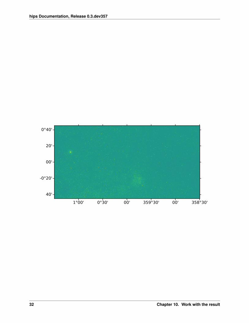
The HipsDrawResult object from the last section makes it easy for you to plot, save or analyse the sky image. Togenerate a quick-look plot of the sky image, with rectangles outlining the HiPS tiles that were fetched and drawn tocreate the sky image:
result.plot()
this will result in the following plot:
To save the sky image to a file:
result.write_image('my_image.fits')
To analyse the data, or make a publication-quality plot, you can get the sky image pixel data as a numpy.ndarray:
>>> result.image
and the sky image astropy.wcs.WCS mapping pixel to sky coordinates via:
>>> result.geometry.wcs
To print out summary information about the result:
>>> print(result)
The HipsDrawResult object also gives access to the HipsTile objects that were used for drawing the sky image, aswell as other things.
31
hips Documentation, Release 0.3.dev357
1°00' 0°30' 00' 359°30' 00' 358°30'
0°40'
20'
00'
-0°20'
40'
32 Chapter 10. Work with the result
CHAPTER 11
Plot using Astropy visualization toolkit
Astropy provides a framework for plotting astronomical images with coordinates. It builds on top of Matplotlib andprovides functionalities such as image normalization (scaling and stretching), smart histogram plotting, RGB colorimage creation from separate images. The framework also allows for customization of plotting styles.
The example below is for the FITS format and controls the stretch of the image through normalization. For FITS tiles,the data type is either int16 or float32:
import matplotlib.pyplot as pltfrom astropy.visualization.mpl_normalize import simple_norm
fig = plt.figure()ax = fig.add_subplot(1, 1, 1)im = ax.imshow(result.image, origin='lower', norm=norm, cmap='gray')fig.colorbar(im)
RGB tiles can be plotted in much the same way as above, however, it is uncommon to apply an extra stretch in thiscase. For jpg and png tiles, the data type is uint8.
Note: For png tiles, there are four channel i.e. RGBA. The alpha channel is used for controlling the transparency ofthe image.
The example provided here is trivial. Astropy provides numerous other features, customizability options, and in-depthexamples. Please see their documentation at: https://docs.astropy.org/en/stable/visualization
33
hips Documentation, Release 0.3.dev357
0 250 500 750 1000 1250 1500 1750 20000
200
400
600
800
1000
2000
4000
6000
8000
10000
34 Chapter 11. Plot using Astropy visualization toolkit

CHAPTER 12
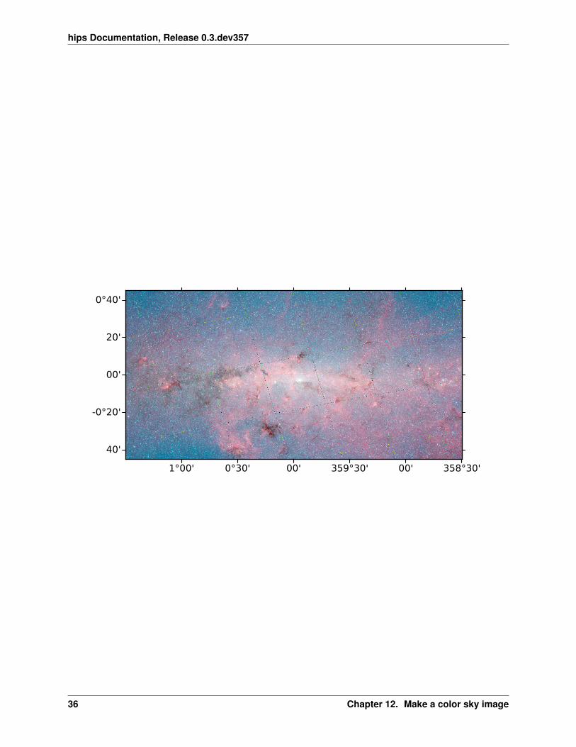
Make a color sky image
HiPS supports color images in jpg and png format. Making a color sky image works the same as the grayscale imageexample above, except that you get back a 3-dim Numpy array with (R, G, B) channels for jpg or (R, G, B, A)channels (A is transparency) for png.
Here’s an example using jpg and http://alasky.u-strasbg.fr/Fermi/Color:
35
hips Documentation, Release 0.3.dev357
1°00' 0°30' 00' 359°30' 00' 358°30'
0°40'
20'
00'
-0°20'
40'
36 Chapter 12. Make a color sky image
CHAPTER 13
HiPS data
We plan to implement functionality to manage HiPS data, i.e. download it and cache it on a local disk. This isn’tavailable yet, at the moment we simply use Python lists of HipsTile objects, which have a read method for a givenfilename and a fetch method for a given URL.
37

hips Documentation, Release 0.3.dev357
38 Chapter 13. HiPS data

CHAPTER 14
More advanced examples
This package is under heavy development, it’s changing quickly.
We’ll add advanced examples and detailed documentation once things have stabilised a bit.
For now, if you know Python, you can look at the code and tests to see what’s available: https://github.com/hipspy/hips
39

hips Documentation, Release 0.3.dev357
40 Chapter 14. More advanced examples
CHAPTER 15
What next?
That’s it, now you’ve seen the main features of the hips package. Note that there is API documentation explaining allavailable functions, classes and parameters.
If you have any questions, or find something not working or a missing feature, please get in touch by posting on ourGithub issue tracker.
41

hips Documentation, Release 0.3.dev357
42 Chapter 15. What next?

Part IV
Reference/API
43

CHAPTER 16
hips Package
A Python astronomy package for HiPS : Hierarchical Progressive Surveys.
At the moment a client for HiPS images, but other contributions (HiPS catalogs or HiPS image generation) welcome!
• Code : https://github.com/hipspy/hips
• Docs : https://hips.readthedocs.io
• License : BSD-3 (see licenses folder for license file)
16.1 Functions
fetch_tiles(tile_metas, hips_survey, . . . ) Fetch a list of HiPS tiles.healpix_to_hips(hpx_data, tile_width, base_path) Convert HEALPix image to HiPS.healpix_to_hips_tile(hpx_data, tile_width, . . . ) Create single hips tile from healpix data given a tile in-
dex.make_sky_image(geometry, . . . ) Make sky image: fetch tiles and draw.test([package, test_path, args, plugins, . . . ]) Run the tests using py.test.
16.1.1 fetch_tiles
hips.fetch_tiles(tile_metas: List[hips.tiles.tile.HipsTileMeta], hips_survey:hips.tiles.survey.HipsSurveyProperties, progress_bar: bool = True, n_parallel: int= 5, timeout: float = 10, fetch_package: str = ’urllib’) → List[hips.tiles.tile.HipsTile]
Fetch a list of HiPS tiles.
This function fetches a list of HiPS tiles based on their URLs, which are generated using hips_survey andtile_metas.
The tiles are then fetched asynchronously using urllib or aiohttp.
Parameterstile_metas : list
45
hips Documentation, Release 0.3.dev357
Python list of HipsTileMeta
hips_survey : HipsSurveyProperties
HiPS survey properties
progress_bar : bool
Show a progress bar for tile fetching and drawing
n_parallel : int
Number of tile fetch web requests to make in parallel
timeout : float
Seconds to timeout for fetching a HiPS tile
fetch_package : {‘urllib’, ‘aiohttp’}
Package to use for fetching HiPS tiles
Returnstiles : list
A Python list of HipsTile
Examples
Define a list of tiles we want:
from hips import HipsSurveyProperties, HipsTileMetafrom hips import fetch_tilesurl = 'http://alasky.unistra.fr/DSS/DSS2Merged/properties'hips_survey = HipsSurveyProperties.fetch(url)tile_indices = [69623, 69627, 69628, 69629, 69630, 69631]tile_metas = []for healpix_pixel_index in tile_indices:
tile_meta = HipsTileMeta(order=7,ipix=healpix_pixel_index,frame=hips_survey.astropy_frame,file_format='fits',
)tile_metas.append(tile_meta)
Fetch all tiles (in parallel):
tiles = fetch_tiles(tile_metas, hips_survey)
16.1.2 healpix_to_hips
hips.healpix_to_hips(hpx_data, tile_width, base_path, file_format=’fits’)Convert HEALPix image to HiPS.
Parametershpx_data : ndarray
Healpix data stored in the “nested” scheme.
tile_width : int
46 Chapter 16. hips Package
hips Documentation, Release 0.3.dev357
Width of the hips tiles.
base_bath : str or Path
Base path.
file_format : {‘fits’, ‘jpg’, ‘png’}
File format to store the hips in.
16.1.3 healpix_to_hips_tile
hips.healpix_to_hips_tile(hpx_data, tile_width, tile_idx, file_format) → hips.tiles.tile.HipsTileCreate single hips tile from healpix data given a tile index.
Parametershpx_data : ndarray
Healpix data stored in the “nested” scheme.
tile_width : int
Width of the hips tile.
tile_idx : int
Index of the hips tile.
file_format : {‘fits’, ‘jpg’, ‘png’}
File format to store the hips tile in.
Returnships_tile : HipsTile
Hips tile object.
16.1.4 make_sky_image
hips.make_sky_image(geometry: Union[dict, hips.utils.wcs.WCSGeometry], hips_survey: Union[str,_ForwardRef(’HipsSurveyProperties’)], tile_format: str, precise: bool = False,progress_bar: bool = True, fetch_opts: dict = None)→ hips.draw.ui.HipsDrawResult
Make sky image: fetch tiles and draw.
The example for this can be found on the Getting started page.
Parametersgeometry : dict or WCSGeometry
Geometry of the output image
hips_survey : str or HipsSurveyProperties
HiPS survey properties
tile_format : {‘fits’, ‘jpg’, ‘png’}
Format of HiPS tile to use (some surveys are available in several formats, so this extraargument is needed)
precise : bool
Use the precise drawing algorithm
16.1. Functions 47
hips Documentation, Release 0.3.dev357
progress_bar : bool
Show a progress bar for tile fetching and drawing
fetch_opts : dict
Keyword arguments for fetching HiPS tiles. To see the list of passable arguments, referto fetch_tiles
Returnsresult : HipsDrawResult
Result object
16.1.5 test
hips.test(package=None, test_path=None, args=None, plugins=None, verbose=False, pastebin=None, re-mote_data=False, pep8=False, pdb=False, coverage=False, open_files=False, **kwargs)
Run the tests using py.test. A proper set of arguments is constructed and passed to pytest.main.
Parameterspackage : str, optional
The name of a specific package to test, e.g. ‘io.fits’ or ‘utils’. If nothing is specified alldefault tests are run.
test_path : str, optional
Specify location to test by path. May be a single file or directory. Must be specifiedabsolutely or relative to the calling directory.
args : str, optional
Additional arguments to be passed to pytest.main in the args keyword argument.
plugins : list, optional
Plugins to be passed to pytest.main in the plugins keyword argument.
verbose : bool, optional
Convenience option to turn on verbose output from py.test. Passing True is the same asspecifying '-v' in args.
pastebin : {‘failed’,’all’,None}, optional
Convenience option for turning on py.test pastebin output. Set to 'failed' to uploadinfo for failed tests, or 'all' to upload info for all tests.
remote_data : bool, optional
Controls whether to run tests marked with @remote_data. These tests use online dataand are not run by default. Set to True to run these tests.
pep8 : bool, optional
Turn on PEP8 checking via the pytest-pep8 plugin and disable normal tests. Same asspecifying '--pep8 -k pep8' in args.
pdb : bool, optional
Turn on PDB post-mortem analysis for failing tests. Same as specifying '--pdb' inargs.
coverage : bool, optional
48 Chapter 16. hips Package
hips Documentation, Release 0.3.dev357
Generate a test coverage report. The result will be placed in the directory htmlcov.
open_files : bool, optional
Fail when any tests leave files open. Off by default, because this adds extra run time tothe test suite. Requires the psutil package.
parallel : int, optional
When provided, run the tests in parallel on the specified number of CPUs. If parallel isnegative, it will use the all the cores on the machine. Requires the pytest-xdist plugininstalled. Only available when using Astropy 0.3 or later.
kwargs
Any additional keywords passed into this function will be passed on to the astropy testrunner. This allows use of test-related functionality implemented in later versions ofastropy without explicitly updating the package template.
16.2 Classes
HipsDrawResult(image, geometry, tile_format, . . . ) HiPS draw result object (sky image and more).HipsPainter(geometry, . . . ) Paint a sky image from HiPS image tiles.HipsSurveyProperties(data) HiPS properties container.HipsSurveyPropertiesList(data) HiPS survey properties list.HipsTile(meta, raw_data) HiPS tile container.HipsTileAllskyArray(meta, raw_data) All-sky tile array container.HipsTileMeta(order, ipix, file_format, . . . ) HiPS tile metadata.WCSGeometry(wcs, width, height) Sky image geometry: WCS and image shape.
16.2.1 HipsDrawResult
class hips.HipsDrawResult(image: numpy.ndarray, geometry: hips.utils.wcs.WCSGeometry, tile_format:str, tiles: List[hips.tiles.tile.HipsTile], stats: dict)
Bases: object
HiPS draw result object (sky image and more).
Parametersimage : ndarray
Sky image (the main result)
geometry : WCSGeometry
WCS geometry of the sky image
tile_format : {‘fits’, ‘jpg’, ‘png’}
Format of HiPS tile
tiles : list
Python list of HipsTile objects that were used
stats : dict
Information including time for fetching and drawing HiPS tiles
16.2. Classes 49

hips Documentation, Release 0.3.dev357
Methods Summary
from_painter(painter) Make a HipsDrawResult from a HipsTilePainter.plot(show_grid) Plot the all sky image and overlay HiPS tile outlines.report() Print a brief report for the fetched data.write_image(filename, overwrite) Write image to file.
Methods Documentation
classmethod from_painter(painter: hips.draw.paint.HipsPainter) → hips.draw.ui.HipsDrawResultMake a HipsDrawResult from a HipsTilePainter.
plot(show_grid: bool = False) → NonePlot the all sky image and overlay HiPS tile outlines.
Parametersshow_grid : bool
Enable grid around HiPS tile boundaries
Uses ‘astropy.visualization.wcsaxes‘.
report()→ NonePrint a brief report for the fetched data.
write_image(filename: str, overwrite: bool = False) → NoneWrite image to file.
Parametersfilename : str
Filename
overwrite : bool
Overwrite the output file, if it exists
16.2.2 HipsPainter
class hips.HipsPainter(geometry: Union[dict, hips.utils.wcs.WCSGeometry], hips_survey: Union[str,hips.tiles.survey.HipsSurveyProperties], tile_format: str, precise: bool = False,progress_bar: bool = True, fetch_opts: dict = None)
Bases: object
Paint a sky image from HiPS image tiles.
Paint HiPS tiles onto a ky image using a simple projective transformation method. The algorithm implementedis described here: HiPS tile drawing.
Parametersgeometry : dict or WCSGeometry
An object of WCSGeometry
hips_survey : str or HipsSurveyProperties
HiPS survey properties
tile_format : {‘fits’, ‘jpg’, ‘png’}
50 Chapter 16. hips Package
hips Documentation, Release 0.3.dev357
Format of HiPS tile
precise : bool
Use the precise drawing algorithm
progress_bar : bool
Show a progress bar for tile fetching and drawing
fetch_opts : dict
Keyword arguments for fetching HiPS tiles. To see the list of passable arguments, referto fetch_tiles
Examples
>>> from astropy.coordinates import SkyCoord>>> from hips import WCSGeometry>>> from hips import HipsSurveyProperties>>> from hips import HipsPainter>>> geometry = WCSGeometry.create(... skydir=SkyCoord(0, 0, unit='deg', frame='icrs'),... width=2000, height=1000, fov='3 deg',... coordsys='icrs', projection='AIT',... )>>> url = 'http://alasky.unistra.fr/DSS/DSS2Merged/properties'>>> hips_survey = HipsSurveyProperties.fetch(url)>>> painter = HipsPainter(geometry, hips_survey, 'fits')>>> painter.draw_hips_order7>>> painter.run()>>> painter.image.shape(1000, 2000)
Attributes Summary
draw_hips_order Compute HiPS tile order matching a given imagepixel size.
image Computed sky image (ndarray).tile_indices Get list of index values for HiPS tiles.tiles List of HipsTile (cached on multiple access).
Methods Summary
draw_all_tiles() Make an empty sky image and draw all the tiles.make_tile_list()plot_mpl_hips_tile_grid() Plot output image and HiPS grid with matplotlib.projection(tile) Estimate projective transformation on a HiPS tile.run() Draw HiPS tiles onto an empty image.warp_image(tile) Warp a HiPS tile and a sky image.
16.2. Classes 51
hips Documentation, Release 0.3.dev357
Attributes Documentation
draw_hips_orderCompute HiPS tile order matching a given image pixel size.
imageComputed sky image (ndarray).
• The dtype is always chosen to match the tile dtype. This is uint8 for JPG or PNG tiles, and can bee.g. int16 or float32 for FITS tiles.
• The output shape is documented here: shape.
tile_indicesGet list of index values for HiPS tiles.
tilesList of HipsTile (cached on multiple access).
Methods Documentation
draw_all_tiles()Make an empty sky image and draw all the tiles.
make_tile_list()
plot_mpl_hips_tile_grid()→ NonePlot output image and HiPS grid with matplotlib.
This is mainly useful for debugging the drawing algorithm, not something end-users will call or need toknow about.
projection(tile: hips.tiles.tile.HipsTile) → skimage.transform._geometric.ProjectiveTransformEstimate projective transformation on a HiPS tile.
run()→ numpy.ndarrayDraw HiPS tiles onto an empty image.
warp_image(tile: hips.tiles.tile.HipsTile) → numpy.ndarrayWarp a HiPS tile and a sky image.
16.2.3 HipsSurveyProperties
class hips.HipsSurveyProperties(data: dict)Bases: object
HiPS properties container.
Parametersdata : dict
HiPS survey properties
52 Chapter 16. hips Package
hips Documentation, Release 0.3.dev357
Examples
>>> from hips import HipsSurveyProperties>>> url = 'http://alasky.unistra.fr/DSS/DSS2Merged/properties'>>> hips_survey_property = HipsSurveyProperties.fetch(url)>>> hips_survey_property.base_url'http://alasky.u-strasbg.fr/DSS/DSS2Merged'
Attributes Summary
astropy_frame Astropy coordinate frame (str).base_url HiPS access URLhips_frame HiPS coordinate frame (str).hips_order HiPS order (int).hips_service_url HiPS service base URL (str).hips_to_astropy_frame_mapping HIPS to Astropy SkyCoord frame string mapping.hips_version HiPS version (str).tile_format HiPS tile format (str).tile_width HiPS tile widthtitle HiPS title (str).
Methods Summary
fetch(url) Read from HiPS survey description file from remoteURL (HipsSurveyProperties).
from_name(name) Create object from Survey ID(HipsSurveyProperties).
make(hips_survey, _ForwardRef()]) Convenience constructor for from_stringclassmethod or existing object(HipsSurveyProperties).
parse(text, url) Parse HiPS survey description text(HipsSurveyProperties).
read(filename) Read from HiPS survey description file(HipsSurveyProperties).
tile_url(tile_meta) Tile URL on the server (str).to_string() Convert properties to stringwrite(path) Write properties to text file.
Attributes Documentation
astropy_frameAstropy coordinate frame (str).
base_urlHiPS access URL
hips_frameHiPS coordinate frame (str).
hips_order
16.2. Classes 53
hips Documentation, Release 0.3.dev357
HiPS order (int).
hips_service_urlHiPS service base URL (str).
hips_to_astropy_frame_mapping = {'ecliptic': 'ecliptic', 'equatorial': 'icrs', 'galactic': 'galactic'}HIPS to Astropy SkyCoord frame string mapping.
hips_versionHiPS version (str).
tile_formatHiPS tile format (str).
tile_widthHiPS tile width
titleHiPS title (str).
Methods Documentation
classmethod fetch(url: str) → hips.tiles.survey.HipsSurveyPropertiesRead from HiPS survey description file from remote URL (HipsSurveyProperties).
Parametersurl : str
URL containing HiPS properties
classmethod from_name(name: str) → hips.tiles.survey.HipsSurveyPropertiesCreate object from Survey ID (HipsSurveyProperties).
classmethod make(hips_survey: Union[str, _ForwardRef(’HipsSurveyProperties’)]) →hips.tiles.survey.HipsSurveyProperties
Convenience constructor for from_string classmethod or existing object (HipsSurveyProperties).
classmethod parse(text: str, url: str = None) → hips.tiles.survey.HipsSurveyPropertiesParse HiPS survey description text (HipsSurveyProperties).
Parameterstext : str
Text containing HiPS survey properties
url : str
Properties URL of HiPS
classmethod read(filename: str) → hips.tiles.survey.HipsSurveyPropertiesRead from HiPS survey description file (HipsSurveyProperties).
Parametersfilename : str
HiPS properties filename
tile_url(tile_meta: hips.tiles.tile.HipsTileMeta) → strTile URL on the server (str).
to_string()Convert properties to string
54 Chapter 16. hips Package
hips Documentation, Release 0.3.dev357
write(path)Write properties to text file.
Parameterspath : str or Path
Base path where to write the properties file.
16.2.4 HipsSurveyPropertiesList
class hips.HipsSurveyPropertiesList(data: List[hips.tiles.survey.HipsSurveyProperties])Bases: object
HiPS survey properties list.
Parametersdata : list
Python list of HipsSurveyProperties
Examples
Fetch the list of available HiPS surveys from CDS:
>>> from hips import HipsSurveyPropertiesList>>> surveys = HipsSurveyPropertiesList.fetch()
Look at the results:
>>> len(surveys.data)335>>> survey = surveys.data[0]>>> survey.title'2MASS H (1.66 microns)'>>> survey.hips_order9
You can make a astropy.table.Table of available HiPS surveys:
>>> table = surveys.table
and then do all the operations that Astropy table supports, e.g.
>>> table[['ID', 'hips_order', 'hips_service_url']][[1, 30, 42]]>>> table.show_in_browser(jsviewer=True)>>> table.show_in_notebook()>>> table.to_pandas()
Attributes Summary
DEFAULT_URL Default URL to fetch HiPS survey list from CDS.table Table with HiPS survey infos (Table).
16.2. Classes 55
hips Documentation, Release 0.3.dev357
Methods Summary
fetch(url) Fetch HiPS list text from remote location(HipsSurveyPropertiesList).
from_name(name) Return a matching HiPS survey(HipsSurveyProperties).
parse(text) Parse HiPS list text (HipsSurveyPropertiesList).read(filename) Read HiPS list from file
(HipsSurveyPropertiesList).
Attributes Documentation
DEFAULT_URL = 'http://alasky.unistra.fr/MocServer/query?hips_service_url=*&dataproduct_type=!catalog&dataproduct_type=!cube&get=record'Default URL to fetch HiPS survey list from CDS.
tableTable with HiPS survey infos (Table).
Methods Documentation
classmethod fetch(url: str = None) → hips.tiles.survey.HipsSurveyPropertiesListFetch HiPS list text from remote location (HipsSurveyPropertiesList).
Parametersurl : str
HiPS list URL
from_name(name: str) → hips.tiles.survey.HipsSurveyPropertiesReturn a matching HiPS survey (HipsSurveyProperties).
classmethod parse(text: str) → hips.tiles.survey.HipsSurveyPropertiesListParse HiPS list text (HipsSurveyPropertiesList).
Parameterstext : str
HiPS list text
classmethod read(filename: str) → hips.tiles.survey.HipsSurveyPropertiesListRead HiPS list from file (HipsSurveyPropertiesList).
Parametersfilename : str
HiPS list filename
16.2.5 HipsTile
class hips.HipsTile(meta: hips.tiles.tile.HipsTileMeta, raw_data: bytes)Bases: object
HiPS tile container.
This class provides methods for fetching, reading, and writing a HiPS tile.
56 Chapter 16. hips Package
hips Documentation, Release 0.3.dev357
Note: In HiPS, the pixel data is flipped in the y direction for jpg and png format with respect to FITS. In thispackage, we handle this by flipping jpg and png data to match the fits orientation, at the I/O boundary, i.e. infrom_numpy and to_numpy.
Parametersmeta : HipsTileMeta
Metadata of HiPS tile
raw_data : bytes
Raw data (copy of bytes from file)
Examples
Fetch a HiPS tile:
>>> from hips import HipsTile, HipsTileMeta>>> meta = HipsTileMeta(order=6, ipix=30889, file_format='fits')>>> url = 'http://alasky.unistra.fr/2MASS/H/Norder6/Dir30000/Npix30889.fits'>>> tile = HipsTile.fetch(meta, url)
The tile pixel data is available as a Numpy array:
>>> type(tile.data)numpy.ndarray>>> tile.data.shape(512, 512)>>> tile.data.dtype.nameint16
Attributes Summary
children Create four children tiles from parent tile.data Tile pixel data (ndarray).
Methods Summary
fetch(meta, url) Fetch HiPS tile and load into memory (HipsTile).from_numpy(meta, data) Create a tile from given pixel data.read(meta, filename) Read HiPS tile data from a directory and load into
memory (HipsTile).to_numpy(raw_data, fmt) Convert raw image bytes to Numpy array pixel data.write(filename) Write to file.
Attributes Documentation
childrenCreate four children tiles from parent tile.
16.2. Classes 57
hips Documentation, Release 0.3.dev357
dataTile pixel data (ndarray).
This is a cached property, it will only be computed once.
See the to_numpy function.
Methods Documentation
classmethod fetch(meta: hips.tiles.tile.HipsTileMeta, url: str) → hips.tiles.tile.HipsTileFetch HiPS tile and load into memory (HipsTile).
Parametersmeta : HipsTileMeta
Metadata of HiPS tile
url : str
URL containing HiPS tile
classmethod from_numpy(meta: hips.tiles.tile.HipsTileMeta, data: numpy.ndarray) →hips.tiles.tile.HipsTile
Create a tile from given pixel data.
Parametersmeta : HipsTileMeta
Metadata of HiPS tile
data : ndarray
Tile pixel data
Returnstile : HipsTile
HiPS tile object in the format requested in meta.
classmethod read(meta: hips.tiles.tile.HipsTileMeta, filename: str = None) → hips.tiles.tile.HipsTileRead HiPS tile data from a directory and load into memory (HipsTile).
Parametersmeta : HipsTileMeta
Metadata of HiPS tile
filename : str
Filename
static to_numpy(raw_data: bytes, fmt: str) → numpy.ndarrayConvert raw image bytes to Numpy array pixel data.
Parametersraw_data : bytes
Raw image bytes (usually read from file or fetched from URL)
fmt : {‘fits’, ‘jpg’, ‘png’}
File format
Returnsdata : ndarray
58 Chapter 16. hips Package
hips Documentation, Release 0.3.dev357
Pixel data as a numpy array
write(filename: str) → NoneWrite to file.
Parametersfilename : str
Filename
16.2.6 HipsTileAllskyArray
class hips.HipsTileAllskyArray(meta: hips.tiles.tile.HipsTileMeta, raw_data: bytes)Bases: hips.HipsTile
All-sky tile array container.
To quote from section 4.3.2 “Allsky preview file” of the HiPS IVOA working draft: “The tiles at low orders (0to 3) may be packaged together into a unique file called Allsky.”
This class implements that all-sky tile array format.
TODO: We’re sub-classing HipsTile here at the moment. This is weird! Probably the current HipsTile shouldbe renamed ImageIO or be split up into functions that do image I/O in the three supported formats?
TODO: We re-use the HipsTileMeta class to store order as well as other info like file_format and frame.Note that ipix doesn’t make sense for an AllSkyTileArray. Maybe there’s a better way to handle this withoutcode duplication?
Examples
Load an example existing HiPS all-sky image (unfortunately one has to pass a dummy ipix value here):
>>> from hips import HipsTileAllskyArray, HipsTileMeta>>> meta = HipsTileMeta(order=3, ipix=-1, file_format='jpg', frame='icrs')>>> url = 'http://alasky.unistra.fr/Fermi/Color/Norder3/Allsky.jpg'>>> allsky = HipsTileAllskyArray.fetch(meta, url)
Now you can extract tiles (e.g. for drawing):
>>> tile = allsky.tile(ipix=42)>>> tile.metaHipsTileMeta(order=3, ipix=42, file_format='jpg', frame='icrs', width=64)
TODO: add an example how to go the other way: combine tiles into an allsky image.
Attributes Summary
height Image pixel height (int)n_tiles Number of tiles in the image (int).n_tiles_in_row Number of tiles per tile row (int).tile_width Pixel width of a single tile (int).tiles Split into a list of HipsTile.width Image pixel width (int).
16.2. Classes 59
hips Documentation, Release 0.3.dev357
Methods Summary
from_tiles(tiles) Create all-sky image from list of tiles.tile(ipix) Extract one of the tiles (HipsTile)tiles_to_allsky_array(tiles) Combine tiles into an all-sky image.
Attributes Documentation
heightImage pixel height (int)
n_tilesNumber of tiles in the image (int).
n_tiles_in_rowNumber of tiles per tile row (int).
tile_widthPixel width of a single tile (int).
tilesSplit into a list of HipsTile.
This is called when using the all-sky image for drawing.
widthImage pixel width (int).
Methods Documentation
classmethod from_tiles(tiles: List[hips.tiles.tile.HipsTile]) → hips.tiles.allsky.HipsTileAllskyArrayCreate all-sky image from list of tiles.
tile(ipix: int) → hips.tiles.tile.HipsTileExtract one of the tiles (HipsTile)
A copy of the data by default. For drawing we could avoid the copy by passing copy=False here.
static tiles_to_allsky_array(tiles: List[hips.tiles.tile.HipsTile]) → numpy.ndarrayCombine tiles into an all-sky image.
16.2.7 HipsTileMeta
class hips.HipsTileMeta(order: int, ipix: int, file_format: str, frame: str = ’icrs’, width: int = 512)Bases: object
HiPS tile metadata.
Parametersorder : int
HEALPix order
ipix : int
HEALPix pixel number
file_format : {‘fits’, ‘jpg’, ‘png’}
60 Chapter 16. hips Package
hips Documentation, Release 0.3.dev357
File format
frame : {‘icrs’, ‘galactic’, ‘ecliptic’}
Sky coordinate frame
width : int
Tile width (tiles always have width = height)
Examples
>>> from hips import HipsTileMeta>>> tile_meta = HipsTileMeta(order=3, ipix=450, file_format='fits')>>> tile_metaHipsTileMeta(order=3, ipix=450, file_format='fits', frame='icrs', width=512)>>> tile_meta.skycoord_corners<SkyCoord (ICRS): (ra, dec) in deg[( 264.375, -24.62431835), ( 258.75 , -30. ),( 264.375, -35.68533471), ( 270. , -30. )]>>>> tile_meta.tile_default_url'Norder3/Dir0/Npix450.fits'>>> tile_meta.tile_default_path.as_posix()'Norder3/Dir0/Npix450.fits'
Attributes Summary
skycoord_corners Tile corner sky coordinates (SkyCoord).tile_default_path Tile relative filename path (Path).tile_default_url Tile relative URL (str).
Methods Summary
copy() An independent copy.
Attributes Documentation
skycoord_cornersTile corner sky coordinates (SkyCoord).
tile_default_pathTile relative filename path (Path).
tile_default_urlTile relative URL (str).
Methods Documentation
copy()An independent copy.
16.2. Classes 61
hips Documentation, Release 0.3.dev357
16.2.8 WCSGeometry
class hips.WCSGeometry(wcs: astropy.wcs.wcs.WCS, width: int, height: int)Bases: object
Sky image geometry: WCS and image shape.
Parameterswcs : WCS
WCS projection object
width, height : int
Width and height of the image in pixels
Examples
To create a WCSGeometry, you can create any WCS and choose an image shape (number of pixels):
from astropy.wcs import WCSfrom hips import WCSGeometrywcs = WCS(naxis=2)wcs.wcs.ctype[0] = 'GLON-AIT'wcs.wcs.ctype[1] = 'GLAT-AIT'wcs.wcs.crval[0] = 0wcs.wcs.crval[1] = 0wcs.wcs.crpix[0] = 1000wcs.wcs.crpix[1] = 500wcs.wcs.cdelt[0] = -0.01wcs.wcs.cdelt[1] = 0.01geometry = WCSGeometry(wcs, width=2000, height=1000)
See also WCSGeometry.create as a simpler (but also not quite as flexible) way to generate WCS and WCSGeometryobjects.
Attributes Summary
WCS_ORIGIN_DEFAULT Default WCS transform origin, to be used in all WCSpix <-> world calls.
celestial_frame Celestial frame for the given WCS (str).center_pix Image center in pixel coordinates (tuple of x, y).center_skycoord Image center in sky coordinates (SkyCoord).fits_header FITS header for the given WCS (Header).pixel_skycoords Grid of sky coordinates of the image pixels
(SkyCoord).
Methods Summary
create(skydir, width, height, fov, . . . ) Create WCS object for given sky image parameters(WCSGeometry).
Continued on next page
62 Chapter 16. hips Package
hips Documentation, Release 0.3.dev357
Table 17 – continued from previous pagecreate_from_dict(params) Create WCS object from a dictionary
(WCSGeometry).make(geometry, _ForwardRef()]) Convenience constructor for create_from_dict class-
method or existing object (WCSGeometry).pix_to_sky(x, y) Helper function to convert pix to sky coordinates.
Attributes Documentation
WCS_ORIGIN_DEFAULT = 0Default WCS transform origin, to be used in all WCS pix <-> world calls.
celestial_frameCelestial frame for the given WCS (str).
Calls wcs_to_celestial_frame.
center_pixImage center in pixel coordinates (tuple of x, y).
center_skycoordImage center in sky coordinates (SkyCoord).
fits_headerFITS header for the given WCS (Header).
pixel_skycoordsGrid of sky coordinates of the image pixels (SkyCoord).
Methods Documentation
classmethod create(skydir: astropy.coordinates.sky_coordinate.SkyCoord, width: int, height: int, fov:Union[str, astropy.coordinates.angles.Angle], coordsys: str = ’icrs’, projection:str = ’AIT’) → hips.utils.wcs.WCSGeometry
Create WCS object for given sky image parameters (WCSGeometry).
Parametersskydir : SkyCoord
Sky coordinate of the WCS reference point
width, height : int
Width and height of the image in pixels
fov : str or Angle
Field of view
coordsys : {‘icrs’, ‘galactic’}
Coordinate system
projection : str
Projection of the WCS object. To see list of supported projections visit: http://docs.astropy.org/en/stable/wcs/#supported-projections
16.2. Classes 63
hips Documentation, Release 0.3.dev357
Examples
>>> from astropy.coordinates import SkyCoord>>> from hips import WCSGeometry>>> skycoord = SkyCoord(10, 20, unit='deg')>>> geometry = WCSGeometry.create(... skydir=SkyCoord(0, 0, unit='deg', frame='galactic'),... width=2000, height=1000, fov='3 deg',... coordsys='galactic', projection='AIT',... )>>> geometry.wcsNumber of WCS axes: 2CTYPE : 'GLON-AIT' 'GLAT-AIT'CRVAL : 0.0 0.0CRPIX : 500.0 1000.0PC1_1 PC1_2 : 1.0 0.0PC2_1 PC2_2 : 0.0 1.0CDELT : -0.0015 0.0015NAXIS : 0 0>>> geometry.shapeShape(width=2000, height=1000)
classmethod create_from_dict(params: dict) → hips.utils.wcs.WCSGeometryCreate WCS object from a dictionary (WCSGeometry).
The extra options are passed to the create class method, it can take the following parameters:
• target
• width
• height
• fov
• coordsys
• projection
For detailed description, see the create class method’s docstring.
classmethod make(geometry: Union[dict, _ForwardRef(’WCSGeometry’)]) →hips.utils.wcs.WCSGeometry
Convenience constructor for create_from_dict classmethod or existing object (WCSGeometry).
pix_to_sky(x, y) → astropy.coordinates.sky_coordinate.SkyCoordHelper function to convert pix to sky coordinates.
64 Chapter 16. hips Package

Part V
Changelog
65


CHAPTER 17
0.3 (unreleased)
• no changes yet
67

hips Documentation, Release 0.3.dev357
68 Chapter 17. 0.3 (unreleased)
CHAPTER 18
0.2
Version 0.2 of hips was released on October 28, 2017.
• Change from using healpy to astropy-healpix. This means hips now works on Windows! [#109]
• Introduce asynchronous fetching of HiPS tiles [#106]
• Add progress bar support for fetching and drawing HiPS tiles [#105]
• Add reporting functionality for HipsPainter [#104]
• Fix tile splitting criterion [#101]
69

hips Documentation, Release 0.3.dev357
70 Chapter 18. 0.2
CHAPTER 19
0.1
This first version of the hips package was released on July 28, 2017. It contains a first implementation to fetch anddraw tiles.
This is a very early release, to get some users and feedback. Note that the API will change in the coming weeks, andyou can also expect new features, fixes and performance and usability enhancements.
The hips package started as a project developed as part of Google summer of code 2017, i.e. planning in early 2017and coding in June 2017.
71

hips Documentation, Release 0.3.dev357
72 Chapter 19. 0.1

Part VI
Develop
73

CHAPTER 20
Hello!
Want to contribute to the hips package?
Great! Talk to us by filing a Github issue any time (it doesn’t have to be a concrete feature request or bug report).
This package was created using the Astropy affiliated package template, and everything works pretty much as inAstropy and most affiliated packages.
We didn’t write any developer docs specifically for this package yet. For now, check out the Astropy core packagedeveloper docs, or just talk to us if you have any questions.
75

hips Documentation, Release 0.3.dev357
76 Chapter 20. Hello!
CHAPTER 21
Install development version
Install the latest development version from https://github.com/hipspy/hips :
git clone https://github.com/hipspy/hipscd hipspip install .
Then run the tests with either of these commands:
python -m pytest -v hipspython setup.py test -V
To run all tests and get a coverage report:
python setup.py test -V --remote-data --coverage
To build the documentation, do:
python setup.py build_docs
77

hips Documentation, Release 0.3.dev357
78 Chapter 21. Install development version
CHAPTER 22
Get the hips-extra test datasets
To run tests accessing files from hips-extra repository:
git clone https://github.com/hipspy/hips-extra.git
Developers must have it cloned on their system, otherwise some test cases will be skipped. This contains tiles fromdifferent HiPS surveys which are used by the drawing module. After this, the HIPS_EXTRA environment variable mustbe set up on their system. On UNIX operating systems, this can be set using
export HIPS_EXTRA=path/to/hips-extra
79

hips Documentation, Release 0.3.dev357
80 Chapter 22. Get the hips-extra test datasets
CHAPTER 23
Why only Python 3?
This package requires Python 3.6 or later.
It will not work with Python 2.7 or 3.5!
This was a choice we made when starting this package in summer of 2017, at a time when Jupyter had just made theirPython 3 only release and other packages we depend on (like Astropy) were about to drop support for legacy Python(Python 2).
Supporting only Python 3 means we e.g. get these benefits:
• async / await for asynchronous HiPS tile fetching (introduced in Python 3.5)
• Keyword-only arguments (introduced in Python 3.0)
• Type annotations (some only introduced in Python 3.6)
• f-strings (introduced in Python 3.6)
At the moment, the only Python 3.6 only feature we use are f-strings, so if several potential users that are on Python3.5 and can’t easily upgrade for some reason complain, we might consider supporting Python 3.5 in the next release.
81

hips Documentation, Release 0.3.dev357
82 Chapter 23. Why only Python 3?
Part VII
HiPS tile drawing
83


hips Documentation, Release 0.3.dev357
This section describes the HiPS tile drawing algorithm implemented in this package, to create a sky image for a givenWCS.
The original description was for the algorithm implemented in Aladin Lite, written by Thomas Boch. In the meantime,the algorithm implemented in this Python package has deviated a bit, they are no longer the same.
The implementation is based on numpy, astropy, healpy and scikit-image.
85

hips Documentation, Release 0.3.dev357
86
CHAPTER 24
Naive algorithm
This is a naive (one could also say: simple and fast) algorithm for drawing HiPS tiles using affine transformations,implemented in the HipsPainter class and usually executed by users via the high-level make_sky_image function.
First we compute and fetch the tiles that are needed for the given sky image:
1. The user specifies a WCSGeometry, which is a astropy.wcs.WCS as well as a width and height of the sky imageto compute.
2. Compute HiPS order corresponding to the requested image size/resolution. The attributes of HiPS propertiesneeded for this are hips_order (order at the tile level) and hips_tile_width (number of pixels for tile widthand height). If hips_tile_width is missing, a default value of 512 is assumed.
3. Compute the list of tiles corresponding to the image FoV. This is done by computing the HiPS tile HEALPixpixel index for every pixel in the sky image and then computing the unique set.
4. Fetch (HTTP calls or from a local cache) all tiles in the list.
Then we draw the tiles one by one using these steps:
1. For each tile, compute the world coordinates of the tile corner vertices, using healpy boundaries function.
2. For each tile, project vertices in image coordinates according to the requested WCS (performing ICRS to Galac-tic frame transformation if the HiPS and sky image aren’t in the same frame already).
3. We extend the tile by 1 pixel in all directions in order to hide “stitches” with other tiles drawing (TODO: notdone yet. needed?)
4. The four corners uniquely define a projective transform between pixel coordinates on the tile and the output skyimage. We use scikit-image to compute and apply that transform, which uses cubic spline interpolation underthe hood. Thus the output is always float data, even if the input was integer RGB image data.
At the moment, we simply initialise the output sky image with pixel values of zero, and then sum the sky images weget from each projected tile. This is inefficient, and can result in incorrect pixel values at the lines corresponding totile borders. We plan to implement a better (more efficient and more correct) way to handle that soon.
Note that any algorithm using interpolation is not fully conserving flux or counts. This might be a concern if you usethe resulting sky images for data analysis. It’s your responsibility to decide if using this method is appropriate for yourapplication or not!
87

hips Documentation, Release 0.3.dev357
88 Chapter 24. Naive algorithm
CHAPTER 25
Tile distortion issue
While the algorithm previously described works fine for HiPS tiles not distorted, it brings some astrometry offsetsfor distorted tiles. This distortion is strongly visible in the HEALPix scheme for tiles at the boundary between theequatorial zone and the polar cap.
An example of such distortions is shown in the example below (uncheck Activate deformations reduction algorithm toview the astrometry offsets): http://cds.unistra.fr/~boch/AL/test-reduce-deformations2.html
To overcome this problem, Aladin Desktop and Aladin Lite use the following recursive strategy: for tiles either toolarge (one edge is >300 pixels when projected) or too distorted (ratio of smaller diagonal on larger diagonal is smallerthan 0.7 and one of the diagonal is > 150 pixels when projected):
• We consider 4 children tiles, dynamically generated from the pixels of their father. Each children tile has a widthand height equal to half of its father’s width/height.
• For each children tile, we compute the world coordinates of its vertices, project them and either draw it if nottoo distorted or repeat the process by splitting again into 4 children tiles.
The recursion is limited by a maximum number of recursive steps (for 512x512 tiles, you are limited to a maximumof 9 steps as 2^9=512) and/or a maximum order (maximum order set arbitrarily at 19 in Aladin Desktop).
89

hips Documentation, Release 0.3.dev357
90 Chapter 25. Tile distortion issue
CHAPTER 26
Precise algorithm
Note: The precise algorithm isn’t implemented yet.
Contrary the previous algorithm which used affine transformations, the idea here for the drawing step is to scan theresult image pixels, and for each of them interpolate (Nearest neighbour or bilinear) the value, ie compute the indexesof nearest neighbour(s), retrieve the values of these pixels and merge them to determine the value of the target pixel.This is very similar to what reproject is doing.
One challenge is that one needs to know how to find the tile and pixel corresponding to a given HEALPix index.The correspondance between a HEALPix index and a pixel in a HiPS tile is given by a hpx2xy array (see methodcreateHpx2xy in class cds.tools.pixtools.Util from Aladin Desktop source code.)
91

hips Documentation, Release 0.3.dev357
92 Chapter 26. Precise algorithm
CHAPTER 27
WCS for FITS tiles
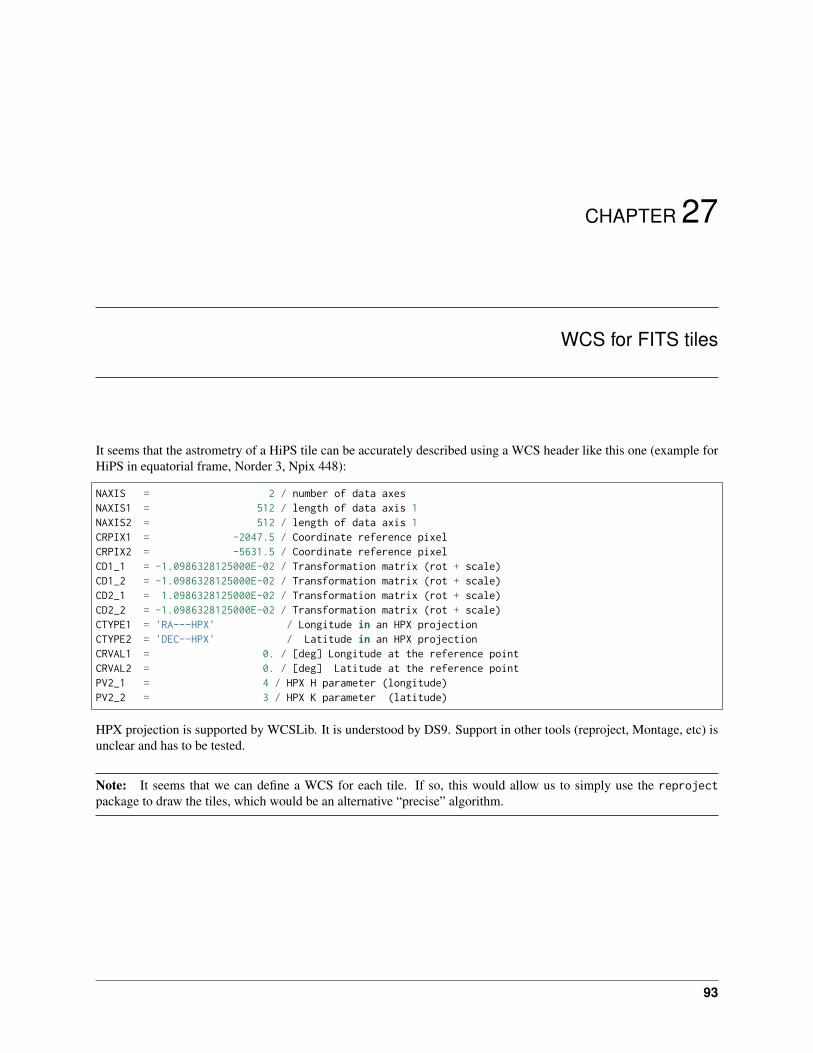
It seems that the astrometry of a HiPS tile can be accurately described using a WCS header like this one (example forHiPS in equatorial frame, Norder 3, Npix 448):
NAXIS = 2 / number of data axesNAXIS1 = 512 / length of data axis 1NAXIS2 = 512 / length of data axis 1CRPIX1 = -2047.5 / Coordinate reference pixelCRPIX2 = -5631.5 / Coordinate reference pixelCD1_1 = -1.0986328125000E-02 / Transformation matrix (rot + scale)CD1_2 = -1.0986328125000E-02 / Transformation matrix (rot + scale)CD2_1 = 1.0986328125000E-02 / Transformation matrix (rot + scale)CD2_2 = -1.0986328125000E-02 / Transformation matrix (rot + scale)CTYPE1 = 'RA---HPX' / Longitude in an HPX projectionCTYPE2 = 'DEC--HPX' / Latitude in an HPX projectionCRVAL1 = 0. / [deg] Longitude at the reference pointCRVAL2 = 0. / [deg] Latitude at the reference pointPV2_1 = 4 / HPX H parameter (longitude)PV2_2 = 3 / HPX K parameter (latitude)
HPX projection is supported by WCSLib. It is understood by DS9. Support in other tools (reproject, Montage, etc) isunclear and has to be tested.
Note: It seems that we can define a WCS for each tile. If so, this would allow us to simply use the reprojectpackage to draw the tiles, which would be an alternative “precise” algorithm.
93

hips Documentation, Release 0.3.dev357
94 Chapter 27. WCS for FITS tiles

Python Module Index
hhips, 45
95

hips Documentation, Release 0.3.dev357
96 Python Module Index
Index
Aastropy_frame (hips.HipsSurveyProperties attribute), 53
Bbase_url (hips.HipsSurveyProperties attribute), 53
Ccelestial_frame (hips.WCSGeometry attribute), 63center_pix (hips.WCSGeometry attribute), 63center_skycoord (hips.WCSGeometry attribute), 63children (hips.HipsTile attribute), 57copy() (hips.HipsTileMeta method), 61create() (hips.WCSGeometry class method), 63create_from_dict() (hips.WCSGeometry class method),
64
Ddata (hips.HipsTile attribute), 57DEFAULT_URL (hips.HipsSurveyPropertiesList at-
tribute), 56draw_all_tiles() (hips.HipsPainter method), 52draw_hips_order (hips.HipsPainter attribute), 52
Ffetch() (hips.HipsSurveyProperties class method), 54fetch() (hips.HipsSurveyPropertiesList class method), 56fetch() (hips.HipsTile class method), 58fetch_tiles() (in module hips), 45fits_header (hips.WCSGeometry attribute), 63from_name() (hips.HipsSurveyProperties class method),
54from_name() (hips.HipsSurveyPropertiesList method),
56from_numpy() (hips.HipsTile class method), 58from_painter() (hips.HipsDrawResult class method), 50from_tiles() (hips.HipsTileAllskyArray class method), 60
Hhealpix_to_hips() (in module hips), 46
healpix_to_hips_tile() (in module hips), 47height (hips.HipsTileAllskyArray attribute), 60hips (module), 45hips_frame (hips.HipsSurveyProperties attribute), 53hips_order (hips.HipsSurveyProperties attribute), 53hips_service_url (hips.HipsSurveyProperties attribute),
54hips_to_astropy_frame_mapping
(hips.HipsSurveyProperties attribute), 54hips_version (hips.HipsSurveyProperties attribute), 54HipsDrawResult (class in hips), 49HipsPainter (class in hips), 50HipsSurveyProperties (class in hips), 52HipsSurveyPropertiesList (class in hips), 55HipsTile (class in hips), 56HipsTileAllskyArray (class in hips), 59HipsTileMeta (class in hips), 60
Iimage (hips.HipsPainter attribute), 52
Mmake() (hips.HipsSurveyProperties class method), 54make() (hips.WCSGeometry class method), 64make_sky_image() (in module hips), 47make_tile_list() (hips.HipsPainter method), 52
Nn_tiles (hips.HipsTileAllskyArray attribute), 60n_tiles_in_row (hips.HipsTileAllskyArray attribute), 60
Pparse() (hips.HipsSurveyProperties class method), 54parse() (hips.HipsSurveyPropertiesList class method), 56pix_to_sky() (hips.WCSGeometry method), 64pixel_skycoords (hips.WCSGeometry attribute), 63plot() (hips.HipsDrawResult method), 50plot_mpl_hips_tile_grid() (hips.HipsPainter method), 52projection() (hips.HipsPainter method), 52
97

hips Documentation, Release 0.3.dev357
Rread() (hips.HipsSurveyProperties class method), 54read() (hips.HipsSurveyPropertiesList class method), 56read() (hips.HipsTile class method), 58report() (hips.HipsDrawResult method), 50run() (hips.HipsPainter method), 52
Sskycoord_corners (hips.HipsTileMeta attribute), 61
Ttable (hips.HipsSurveyPropertiesList attribute), 56test() (in module hips), 48tile() (hips.HipsTileAllskyArray method), 60tile_default_path (hips.HipsTileMeta attribute), 61tile_default_url (hips.HipsTileMeta attribute), 61tile_format (hips.HipsSurveyProperties attribute), 54tile_indices (hips.HipsPainter attribute), 52tile_url() (hips.HipsSurveyProperties method), 54tile_width (hips.HipsSurveyProperties attribute), 54tile_width (hips.HipsTileAllskyArray attribute), 60tiles (hips.HipsPainter attribute), 52tiles (hips.HipsTileAllskyArray attribute), 60tiles_to_allsky_array() (hips.HipsTileAllskyArray static
method), 60title (hips.HipsSurveyProperties attribute), 54to_numpy() (hips.HipsTile static method), 58to_string() (hips.HipsSurveyProperties method), 54
Wwarp_image() (hips.HipsPainter method), 52WCS_ORIGIN_DEFAULT (hips.WCSGeometry at-
tribute), 63WCSGeometry (class in hips), 62width (hips.HipsTileAllskyArray attribute), 60write() (hips.HipsSurveyProperties method), 54write() (hips.HipsTile method), 59write_image() (hips.HipsDrawResult method), 50
98 Index