Embed Size (px)
Citation preview

Hindu Kush Chitral
Geological map GIS data base
Generation of a 1:100000 Geological Map of Central Chitral (Hindu Kush, North Pakistan) by Means of GIS-Software MANFRED F. BUCHROITHNER1 and KIRSTEN ZIMMER1
3 Figures and 1 colour map
Content
Zusammenfassung 11 Abstract 11
1. Introduction 11 2. Geographical Setting 12 3. Geological Setting 12 4. Analog Geological Data Bases 13 5. Hard- and Software 13 6. Geological GIS and Map Production 15 7. Concluding Remarks 15
References 15
Erstellung einer Geologischen Karte von Zentral-Chitral (Hindukush, Nordpakistan) im Maßstab 1:100000 mittels GIS-Software
Zusammenfassung Von Zentral-Chitral (Nord-Pakistan) sind mittels Arclnfo sowohl eine geologische GIS-Datenbank als auch eine geologische Karte erstellt
worden. Sie beruht auf einer soliden topographischen Basis und weist eine stratigraphische Farbkodierung mit lithologischen Rastersignaturen auf. Der gesamte Herstellungsgang, die Vor- und Nachteile der verwendeten Software-Pakete sowie die geometrische und thematische Qualität der einzelnen Datenebenen werden beschrieben. Sie sind in ihrer Art die ersten des westlichen Himalaya-Systems.
Abstract Both, a geological GIS data base, a digital and an analog geological map of Central Chitral (Northern Pakistan), have been generated by
means of Arclnfo. The maps display a sound topographic basis, stratigraphic colour-coding and lithological raster signatures. Their production, the benefits and shortcomings of the software used, and the geometric and thematic quality of the data sets are described. They represent the first ones of the Western Himalayan System.
1. Introduction
Despite the fact that in general GIS applications have tre- (Voss and OCKMANN 1992). In 1993 the Geological Survey of mendously increased within the last decade, until recent years Austria (GBA) started with the GIS-based digital production of the establishment and use of GIS in geology proper was only their geological maps (JANOSCHEK et al. 1993, PASCHER et al. coming up quite hesitantly. This statement applies even more 1996), thus following the German Federal Office for Geology to less well-mapped remote areas. Even if geological GIS and Raw Materials (BGR) who had made this step shortly data bases have been set-up, so far the computer-based, before (Voss and OCKMANN 1992). Within the German speak-procedure-assisted generation of the highly complicated geo- ing domain, one significant approach has been made by logical maps of remote Asian areas using GIS software has STEIN (1995) who accomplished the incredible task of gener-not been materialised too often. ating geological, i. e. mainly lithological, signatures for 2478
By the end of the eighties digital cartography, soon based rock types. Her work served as a significant basis for the on layer-structured GIS data sets, began to enter geology present map generation.
Address of the authors 1 Manfred F. BUCHROITHNER and Kirsten ZIMMER, Institute for Cartography, University of Technology, D- 01062 Dresden, Germany

12 M. F. BUCHROITHNER, K. ZIMMER
2. Geographical Setting
Chitral, a mountain land situated between 35° and 37° North and 71° and 74° East, represents a portion of the Hindu Kush-Karakorum System. In administrative terms it belongs to the North-West Boundary Province of Pakistan. To the North the famous Afghan Wakhan Corridor separates it from the Republic of Tadjkistan and the Pamirs, to the Northeast the Hunza Valley forms the border to China. Since the 19th century or even earlier the map area, located at the border to Afghanistan and influenced by Russia, China and British India, represents a politically sensitive terrain.
Chitral trends in Northeast-Southwest direction, following a major valley system of approximately 300 km in length. It is characterized by a rather narrow, but in its lower course widening river valley (until north of Chitral town) and a narrow and well-structured central portion. In the higher parts of Chitral fertile valley bottoms reach up to approximately 3000 m. This is due to the intensive glacier coining of the main and the side valleys. The accompanying mountain ranges on both sides of the Chitral Valley reach up to 7000 m, culminating in the Tirich Mir (7706 m), the highest peak of the whole Hindu Kush Range. The major settlement and administrative and commercial centre of Chitral is Chitral Town with some 11 000 inhabitants (according to HASERODT 1989). The total population of Chitral amounts to approximately 200000 (around 1990).
The climate of Chitral is determined by its situation in a subtropical zone with arid summers, between Far East and Central Asia and the northern rim of South Asia. Major pre-cepitation occurs during winter and spring. In spring and summer the major valleys are frequently beaten by very strong adiabatic winds which can reach the intensity of sandstorms.
Vegetationwise Chitral shows a big variety. Oasis-like, tree-rich settlement patches in the major valleys are spotted within semi-desert terrain and artemisia steppes. Frequently the valley slopes are covered by stone oak and pine forests, in higher regions culminated by coniferous forests and a narrow zone of alpine meadows.
Geomorphologically Chitral is dominated by strong hypsometric alternations. In southern Chitral wide valleys with old valley fillings and extensive terraces are predominant, the side valleys are mainly V-shaped. Central Chitral, as already mentioned, shows narrow valleys with little widenings. The latter ones are frequently filled with extensive talus fans at the bottom of the mouths of the tributaries. They serve as the favourite settlement spots. North and Northeast Chitral is characterized by mainly U-shaped valleys. With a total area of approximately 1460 km2 Chitral shows a glacial coverage of about 10% (GRUBER 1977). Glacier surfaces are characterised by a thick scree coverage.
3. Geological Setting
Geologically, and in particular tectonically, Chitral and its surroundings are characterised by a suture zone between the Asian and Indian Plate. The southern continental margin of the Asian plate and the Cretaceous Kohistan Island Arc are colliding here. The resulting Middle Cretaceous Northern Suture runs as a wide melange zone along the north-south trending Shishi Valley. It contains green and calcareous schists, clastic material, metavulcanites and carbonatic rocks.
The lithological content of the Asian Plate in Chitral is determined by thick more or less metamorphic Palaeozoic to Lower
Fig. 1 Location map showing the geographic setting of the map area.
10 20 30 km

Generation of a 1:100000 Geological Map of Central Chitral (Hindu Kush, North Pakistan) by Means of GIS-Sofrware 13
Fig. 2 Outline of the three manuscript maps which provided the major basis for the Geological Map of Chitral (from north to south, with overlap areas): "Chitral und Umgebung" (KRIEGL 1991), "Ayun und Umgebung" (HEISS 1992), "Drosh und Umgebung" (BAUER 1994).
71°30' 72°00'
36°00'
35°30'
( V
***>.
AFGHA
NISTAN
"\
(
I \ \ 0 5 10 15 20 25 km
36°00'
35°30'
71°30' 72°00'
Mesozoic sedimentary series intruded by (Cretaceous to) Tertiary magmatites. The southern rim of this plate is basically formed by two tectonic units (Northwest Unit and Central Unit), which are separated by a steeply north-dipping fault, the Reshun Fault. It is also the border line between the Palaeozoic sediments and the Cretaceous carbonates (DESIO 1963, BUCHROITHNER und GAMERITH 1986).
The so-called Kohistan Island Arc is mainly formed by the Kohistan Batholith, an Upper Cretaceous Palaeocene gabbro-diorite to granite. This pluton intruded from south to north into various Palaeozoic to Lower Mesozoic formations. More details on the geology of the area can be taken from the three theses of KRIEGL (1991), HEISS (1992), and BAUER (1994) as well as from BUCHROITHNER and GAMERITH (1986) and PUDSEY et al. (1985). The geological map compiled by GAMERITH (1979) is old but not yet too much outdated and gives an excellent overview over the whole region of Gilgit, Chitral and the Wakkan.
4. Analog Geological Data Bases
The basis of the set-up of the present geological GIS is formed by three manuscript maps produced within the diploma thesis works of three students of the University of Graz, Austria: KRIEGE (1991), HEISS (1992), and BAUER (1995). Within a geological research program, which also led to the generation of a geological map of the highest massif of the Hindu Kush, the Tirich Mir (BUCHROITHNER & KOSTKA 1986, BUCHROITHNER and GAMERITH, 1986), a remote sensing-based geological mapping campaign (ct. KRONBERG 1985) has been performed, which resulted in a series of 1:50000 geological
maps. The outline of the three maps used within this project is given in Figure 2. The three map sheets are called "Chitral Town and Surroundings", 'Ayun and Surroundings" and "Drosh and Surroundings". Since our new map also displays a detailed topographic network and a geological source index, the individual sheet boundaries and overlap areas can be deduced in detail. The remote sensing imagery KRIEGL, HEISS, and BAUER used for geological mapping stems from space-borne stereoscopic photographs (Large Format Camera [LFC] stereo triplet and Handheld Space Shuttle Earth Observation Program - SSEOP - stereo photopairs), and non-stereoscopic spaceborne scanner data (Landsat MSS and SPOT XS). While the LFC photographs were taken in the panchromatic black-and-white mode, the handheld SSEOP images were full-colour.
5. Hard- and Software
In the following the hard- and software platforms used for the present project shall be briefly described. Since the entire GIS and map generation process has been carried out at the Institute for Cartography of the Dresden University of Technology, the computing facilities running there defined the peripheral conditions of the activities. In particular, the present work was performed on an XIL 220 workstation with 64 MB main memory and 4.5 GB disc memory. Based on the operating system SOLARIS 2.6 and the graphic user interface CDE, Arclnfo Version 7.1.1 was used. A 21-inch screen served as display. Digitising was done on a Calcomp A0 digitising table. Data transfer between the workstation and the other PCs used was performed by means of FTP
14 M. F. BUCHROITHNER, K. Z MMER
/Topographic maps / / Geological / / / / Geological maps / / Material for geo- / / 1 • 63 360 / / m a t l u s c n P t m a P s / / Satellite images / / as comparative / / logical cross-section / / ' // 1 :50 000 II II material / / and location maps /
1 1 1 1 1 I
' Definition and design of cartographic elements for thematic map contents;
design of geological cross-section, location maps, legends i (using Macromedia Freehand 5.0) J
~r Preparation of digitising material for
topographic hase-map elements in the form of blueprints of topomap sheets ,
\ Generation of TicCoverages
I
I Preparation of digitising copies for location
maps; import of geometry data from Macromedia Freehand 5.0 into Arclnfo ,
Digitising of all map elements
I Establishment of topology
Editing of digitised data
I Transformation into true map coordinates
Merging of coverages of same thematic content
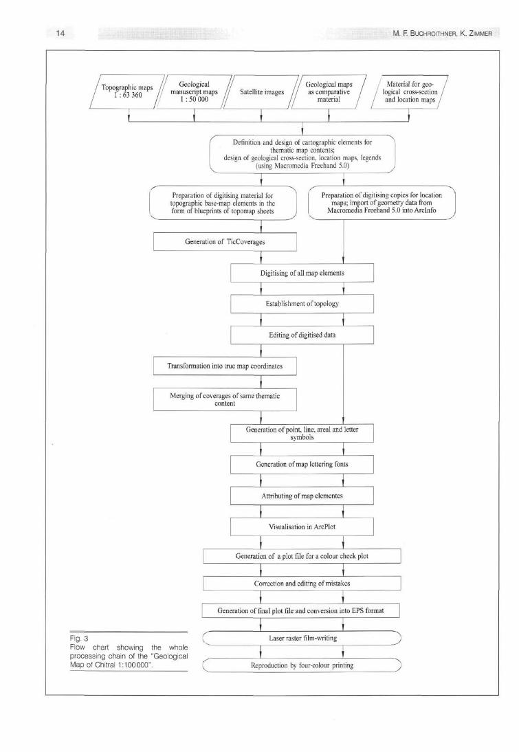
Fig. 3
I Generation of point, line, areal and letter
symbols
Generation of map lettering fonts
I Attributing of map elementes
I Visualisation in ArcPlot
Generation of a plot file for a colour check plot
I Correction and editing of mistakes
I Generation of final plot file and conversion into EPS format
Flow chart showing the whole processing chain of the "Geological Map of Chitral 1:100000". (
I Laser raster film-writing
I Reproduction by four-colour printing
)
) '

16 M. F. BUCHROilHNER, K. ZIMMER
BUCHROITHNER, M. F, 1989: Fernerkundungskartographie mit Satellitenaufnahmen - Digitale Methoden, Reliefkartierung, geowissen-schaftliche Applikationsbeispiele. Enzyklopädie „Die Kartographie und ihre Randgebiete". - (Ed. Arnberger, E.), IV/2, 523p., Franz Deuticke, Vienna.
BUCHROITHNER, M. F and GAMERITH, H., 1986: On the Geology of the
Tirich Mir Area, Central Hindu Kush (Pakistan). - Jahrbuch Geologische Bundesanstalt 1986, 128/3-4, 367-381, Vienna.
BUCHROITHNER, M. F. and KOSTKA, R., 1986: Die Kombination von terrestrischen und Fernerkundungsaufnahmen, gezeigt am Beispiel der Geologischen Karte des Tirich Mir-Gebietes (Hindukusch/ Pakistan). - Mitteilungen der Österreichischen Geographischen Gesellschaft, 128, 138-146, Vienna.
DESIO, A., 1963: A Review of the Geologie "Formations" of the Western Karakorum (Central Asia). - Riv. Ital. Paleont., LXIX, 475-501, Milano.
GAMERITH, H., 1979: Geologische Karte von Gilgit/ Chitral/ Wakkan (Nordpakistan und Ostpakistan) 1:250000. - Private Publication, Graz.
GRUBER, G., 1977: Gletscher und Schneegrenze in Chitral. - Frankfurter Wirtschafts- und Sozialkritische Schriften, 26, 97-139, Frankfurt am Main.
HASERODT, K., 1989: Hochgebirgsräume Nordpakistans im Hindukusch, Karakorum und Westhimalaja - Beiträge zur Natur- und Kulturgeographie. Beiträge und Materialien zur regionalen Geographie. 2, 233p., Institute for Geography, Berlin University of Technology
HEINE, E. and KosTkA, R., 1998: Probleme der Auswertung von GPS-Messungen: Referenz-Systeme und Positionierungen im Tibetischen Himalaya. - 31p., Academic Publishing, Graz.
HEISS, H.-P, 1992: Geologische Fernerkundung von ausgewählten Gebieten der Sulaiman Range und des Hindukusch, Pakistan. -Diploma Thesis, Institute for Geology and Paleontology, Faculty of Natural Sciences, University of Graz, 109p., 19maps.
JANOSCHEK, W, PASCHER, G. A. and STRAUSS, U. R., 1993: A Database
of the Content of Geological Maps (GEOMAP) and the Computer-Assisted Production of the Geological Map 1:50000 of Austria as a Major Part of the Austrian Geological Information System. - Geoin-formatics, 4/3, 239-244, Japan Soc. Geoinform., Kyoto.
KRIEGL, CH., 1991: Geologische Fernerkundung (semi)arider Gebirge in Pakistan (Sulaiman Range und Chitral) mit kosmischen Aufnahmen. - Diploma Thesis, Institute for Geology and Paleontology, Faculty of Natural Sciences, University of Graz 126p., 17maps.
KRONBERG, R, 1985: Fernerkundung der Erde - Grundlagen und Methoden des Remote Sensing in der Geologie. Ferdinand Enke Publishing House, Stuttgart, 393p.
PASCHER, G. A., LASCHEND, S. PUHM, E. and STÖCKL, W., 1996: Die
Digitale Geologische Karte von Österreich (GÖK) 1:50000, 1:200000 und 1:500000 - Datenbank und computergestützte Kartenproduktion. - Wiener Schriften zur Geographie und Kartographie, 9, 37-58, Vienna.
PUDSEY, C. J., SCHROEDER, R. and SHELTON, P W., 1985: Cretaceous (Aptian - Albian) Age for Island Arc Volcanics, Kohistan, N. Pakistan. - In: GUPTA, V. J. (Ed.), Contributions to Himalayan Geology. 3, 150-168, Hindustan Publishing Comp., Delhi.
STEIN, C, 1995: Erarbeitung eines Normierungsvorschlages für die Verwendung von Farbe und Signatur im geowissenschaftlichen Kartenwerk Sachsens. - Diploma Thesis, Institute for Cartography, Dresden University of Technology, 132p.
Voss, H.-H. and OCKMANN, M., 1992: Fundamentals of Digital Geological Maps: Elements, Interpretations, and Constraints. Geologisches Jahrbuch, A 122, 217-231, Hannover.
ZIMMER, K., 1998: Erstellung einer geologischen Übersichtskarte der Umgebung der Stadt Chitral (Hindukusch - Nordpakistan) im Maßstab 1:100000 aus drei geologischen Manuskriptkarten mittels GIS-Software. Diploma Thesis, Institute for Cartography, Dresden, University of Technologie, 101 p., 1 map.
Manuscript received: 23. 10. 1998 • Revised version received: 26. 08. 1999 •
Manuscript accepted: 21. 01. 2000 •


i',,if."-r-:)r .;l I CO ÜO0H .-.;il Mt::;-or Ccvrr.v CT :\il Norl- ::i'j:.l';r- •Mj. ir- :
6. Geological GIS and Map Production
All three manuscript maps mentioned in Section 4 have been digitised manually. In total, 4 classes of linear geological features (edges) and 27 classes of areal features, i.e. litho-logical (and glacial) units, have been discarded (cf. map legend).
Prior to that, however, a sound and geometrically valid topographic basis had to be generated. Due to the fact that no adequate recent maps were available, this was done using four sheets of the Topographic Map 1:63360 published by the Survey of India in 1928. The mediocre geometric accuracy of this map is described by HEINE and KOSTKA (1998). Since in Chitral there are only few jeepable roads and footpaths, the drainage network served as the main topographic reference. Thus, the complete surface hydrology, was digitised. For improved map visualisation, only the first four orders of the rivers have been used which corresponds to a reduction of the drainage density down to approximately one quarter of the initial data set. The reason for this is the significantly better legibility of the map. On the screen, however, the GIS user can display the complete high-density drainage network, if needed.
By means of a "rubber sheeting" with second order polynomials and an edge adjustment function of the Arclnfo software the four individual coverages of the topomap sheets were geometrically aligned and combined into one coverage for the topographic and the thematic layers. This resulted in a spatial accuracy of approx. 1.6 pixels, a value which can be considered excellent for this area. The ambiguities of the lithological boundaries and fault lines along the edges of the initial coverages were clarified by means of visual satellite image interpretation (cf. Section 4).
During the set-up of the topology using the module Arc an attribute table has been generated to which symbol numbers of the individual objects have been asigned using ArcEdit.
Since the geological GIS data base had been generated using Arclnfo, it was at hand to apply the core module Arc as well as ArcEdit, ArcPlot and the programming language AML for the map generation. For the map design Aldus Freehand 5.0, installed on various PCs, was used. This comprehends mainly the definition of the colours and signatures of the geological units, the draft of the legend and the geological cross-section, and the general layout of the small location maps.
For the actual cartographic modeling, the colour coding, and the whole lettering the module ArcPlot was used. It contains a marker edit, line edit, shade edit, and text edit menue for the definition of the cartographic representation for point, line, area, and text elements. As for the lithological units a combination of a stratigraphic colour coding following the international conventions and of petrographic raster signatures has been materialised.
The strange six-cornered shape of the map field proper and the map projection yielded some problems. The Arclnfo software is evidently not well-suited for irregular map shapes like the one of the Geological Map of Chitral. Moreover, the projection of the old one-inch maps of the Survey of India is not easily retrievable. (It is, by the way, not indicated on the map sheets.) According to HEINE and KOSTKA (1998) it is the Con-formal Conical Lambert Projection. By means of an exact indication both the geodetic and the geographic coordinates in the map's double frame a precise linking to adjacent geological map sheets is possible.
The geological faults and lineaments contained in KRIEGL'S, HEISS'S, and BAUER'S manuscript maps have been checked
and completed using the geological map of GAMERITH (1979) and additional - also stereoscopic - satellite image interpretation. The positioning of the geological-cross section is based on BAUER (1994). His thesis also provided the geometric basis for the design of the section by means of Macromedia FreeHand. This software easily allows the drawing and manipulation of curved (Bezier) lines. After final construction the geological profile was transferred into Arclnfo for attribution using ArcEdit. FreeHand was also used for the initial design of the location maps and the legend.
In Pakistan English is the official administrative language. In English you do not have diacritic signs. Thus, geographic names were written in a way following the official "Atlas of Pakistan" from 1985 and the British "Times Atlas of the World" edited by BARTHOLOMEW (1959).
The processing of the lettering was a particular problem, as the interested and careful map user can easily notice. Since Arclnfo is an excellent GIS, but by no means a real cartographic software, it needed a lot of efforts to reach a reasonable result. Those interested in details are kindly referred to the diploma thesis of Kirsten ZIMMER (1998).
The Separator menue of Arclnfo served for the transformation of the whole data set into a colour-separated EPS (Encapsulated PostScript) Format which allows the definition of resolution and raster size for the laser filmwriter. We used a resolution of 2540 dpi and a raster size of 175 Ipi. The final EPS file amounted to 44 MB. Printing has been accomplished in a four-colour mode, using a mat-white 135-g paper. The final size of the map as such is 469 mm x 558 mm, the printing format being 698.8 mm x 705 mm. The paper format is 720.8 mm x 727 mm. 1200 copies have been produced. Prior to printing, however, a full-size colour check-plot has been plotted and a Cromalin colour proofing been made, thus more or less following the schemes given by JANOSCHEK et al. (1993: Fig. 3) and PASCHER et al. (1996: Fig. 3). In this paper Fig. 3 displays a flow chart showing the generation of the map. The digital geodata base is archived at the Institute for Cartography of the Dresden University of Technology.
7. Concluding Remarks
Both the geological GIS data set of Central Chitral and its visualisation as a geological map have been generated using the software system Arclnfo. In this context they represent the first of their kind for the western Himalayan System.
Based on the internationally common stratigraphic colour coding and petrographic raster symbols (signatures), particular attention was put on an easily legible map design. This goal was quite hard to accomplish, since Arclnfo is not a real cartographic software. In any case, exploiting the possibilities of Arclnfo to the uttermost and making use of the more design-friendly Macromedia FreeHand package, a modern digital map data base and an appealing geological paper map have been produced.
References
BARTHOLOMEW, J. (Ed.), 1959: Times Atlas of the World. -Vol. II, 51 p., 48maps, The Times Publishing Comp. Ltd., London.
BAUER, R., 1994: Geologische Fernerkundung (semi)arider Gebirgs-regionen am Beispiel ausgewählter Gebiete der Sulaiman Range und des Hindukush (Pakistan). - Diploma Thesis, Institute for Geology and Paleontology, Faculty of Natural Sciences, University of Graz, 147p., 8maps.