Embed Size (px)
Citation preview
CCHHAAPPTTEERR 55 EEXXIISSTTIINNGG CCOONNDDIITTIIOONNSS
Wilbur Smith Associates Page 5-1
An inventory of the existing transportation infrastructure in Louisiana was conducted as an initial task in the development of the Louisiana Statewide Transportation Plan. This chapter provides an overview of the existing transportation system for all modes of transportation including the highway system, trucking, aviation, freight rail, ports and waterways, surface passenger transportation, bicycle and pedestrian facilities, and intelligent transportation systems.
HHIIGGHHWWAAYY SSYYSSTTEEMM Louisiana’s highway network is the 32nd largest in the nation, with the State highway system the 11th largest. The network is comprised of over 60,000 miles and more than 13,000 bridges under the jurisdiction of federal, state and local governments and entities. The 27.4 percent of highway network centerline mileage which are State-owned places Louisiana 10th nationally, while the 30 percent of total highway network lane mileage which are State-owned, places Louisiana 11th.
The network typically handles just under 41 billion miles traveled annually. While a larger percentage of total vehicle miles traveled is on rural roads and highways, the urban highway system is experiencing a greater percentage of vehicle miles traveled when compared to the highway mileage available. Of Louisiana’s 4,468,976 citizens, 2,759,120 are licensed drivers. The State ranks 47th nationally in the number of licensed drivers per 1,000 persons, at 617. Drivers averaged 14,915 miles traveled for 2000, placing Louisiana 28th nationally.
Figure 5.1 displays the existing highway network in Louisiana. The highway network consists of several Interstate highways including I-10, I-12, I-20, I-49, I-55 and I-59. Major US highways in Louisiana include US Routes 51, 61, 65, 71, 79, 80, 84, 90, 165, 167, 171, 190, 371 and 425.
Functional Classification
Functional classification of transportation facilities are designed to describe the hierarchical arrangement and interaction between various roadways. Classification is based on each roadway’s functional role in the overall network, including traffic movement and access. Louisiana’s highway network is classified in the following categories:
• Interstate • Other Freeway/Expressway • Other Principal Arterial • Minor Arterial • Collector • Local
Table 5.1 shows Louisiana’s highway network by functional classification and jurisdiction. As shown Louisiana’s highway network comprises over 60,000 miles of Interstate, Freeway, Arterial, Collector and Local roadways. Interstate and Principal Arterial roadways comprise 893 (1.2 percent) and 2,012 (3.5 percent) miles respectively. The majority of the total public roadway network is under Parish jurisdiction.

Existing Conditions
Page 5-2
Figure 5.1

Existing Conditions
Page 5-3
Table 5.1 Louisiana Highway Network
Functional Classification by Jurisdiction
State Parish City Total Interstate 893 0 0 893 Other Freeway/Expressway 45 0 0 45 Other Principal Arterial 1,801 64 102 1,967 Minor Arterial 2,532 218 518 3,268 Collector 8,723 326 858 9,907 Local 2,706 32,703 9,423 44,832 Total 16,700 33,311 10,901 60,912 Source: DOTD, US DOT – FHWA, Office of Highway Policy Information, 2000.
Interstate Highway System
Louisiana’s 893-mile Interstate system represents only 1.2 percent of the total highway network mileage, yet accounts for 25 percent of the total traffic volume. The Interstate network plays an integral role in the health of the State’s economy through the provision of freight and passenger transport facilities, and thus the maintenance and preservation of the system is a core objective of the State’s transportation planning initiatives.
As shown in Figure 5.2, traffic volume on Louisiana’s rural Interstate system is higher than the US average. Nearly 90 percent of the State’s rural Interstate network had ADT volumes of more than 10,000, as compared to less than 77 percent nationally. The largest ADT volume (20,000 and greater) is found on almost two-thirds of the State’s rural Interstate network.
Figure 5.2
Rural Interstate ADT Louisiana vs. US Average
Source: Highway Statistics, US DOT – FHWA, Office of Highway Policy Information, 2000.
0.0%
10.0%
20.0%
30.0%
40.0%
50.0%
Louisiana 2.1% 8.0% 26.5% 63.4%
US 10.4% 12.3% 29.5% 47.8%
<6,000 6,000-9,999 10,000-19,999
>20,000
Existing Conditions
Page 5-4
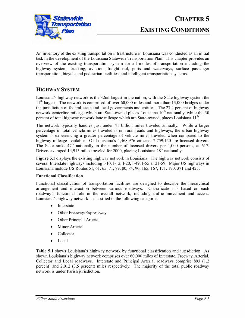
As shown in Figure 5.3, Louisiana’s urban Interstate system is not as heavily traveled when compared to the national average. ADT volumes of more than 60,000 vpd are found on roughly 21 percent of the State’s urban Interstate network, compared with 52 percent nationally. ADT volume between 35,000 and 59,999 provides the largest percentage of urban Interstate travel at close to 42 percent.
Figure 5.3 Urban Interstate ADT
Louisiana vs. US Average
0.00%
10.00%
20.00%
30.00%
40.00%
50.00%
Louisiana 7.47% 29.18% 42.35% 12.46% 8.54%
U.S. 4.28% 17.39% 25.93% 22.62% 29.78%
<15,000 15,000-34,999
35,000-59,999
60,000-99,999 >100,000
Source: Highway Statistics, US DOT – FHWA, Office of Highway Policy Information, 2000
National Highway System
Through the National Highway System Designation Act of 1995, up to 178,250 miles of national highway facilities may be designated as part of the National Highway System (NHS). The NHS will become the focal point of future federal interest due to the inclusion of the Interstate system and selected non-Interstate principal arterial routes. As of the Year 2000, the total mileage of the NHS open to traffic stood at 160,788. Louisiana’s portion as of this same date was 2,599 miles, or approximately 1.6 percent. The State’s Interstate portion of its NHS mileage is 34.3 percent, compared to the national average of 29 percent. Both statewide and nationally, the majority of the NHS is drawn from the non-Interstate principal arterial network.
Utilizing volume-service flow ratios of >0.80 as a determinant of system congestion, Louisiana’s National Highway System mileage parallels the total highway network mileage, in that congestion is disproportionately higher on the urban network. Just over one percent of the rural NHS network has a volume-to-service ratio greater than 0.80, while over 29 percent of the urban NHS network meets that congestion threshold.
Existing Conditions
Page 5-5
Rural vs. Urban
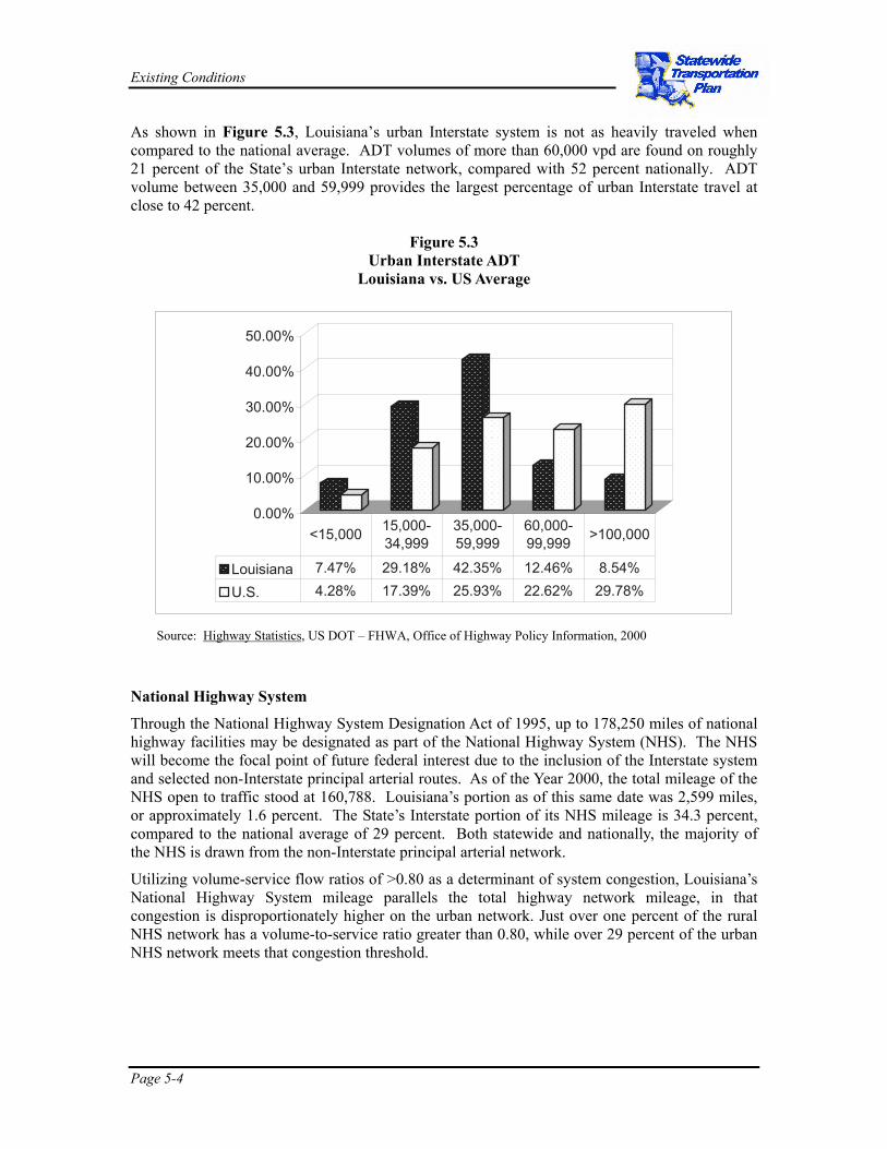
Figure 5.4 displays the percent of highway mileage and vehicle miles of travel along rural and urban highways. As shown, three-quarters of the highway network mileage and just over half of the traffic volume are in rural areas. While a greater proportion of highway mileage traveled is in rural areas, when comparing highway mileage to vehicle miles traveled, Louisiana’s travel patterns are placing a greater burden upon the urban highway network.
Figure 5.4 Percent of Highway Mileage and Vehicle Miles of Travel (VMT)
0.00%
20.00%
40.00%
60.00%
80.00%
VMT 54.27% 45.73%
Highway Mileage 77.11% 22.89%
Rural Urban
Source: Highway Statistics, US DOT – FHWA, Office of Highway Policy Information, 2000.
Bridges
The ratio of bridges to total highway miles places Louisiana 5th nationally. Due to the frequency with which bridges are observed throughout the State’s highway network, the condition of the highway bridge system is potentially at a higher priority within the highway network when compared to other states.
Louisiana’s 13,426 bridges rank it 20th nationally; 121 out of this total are movable, allowing for clearance of maritime traffic. Of the total number of bridges, 2,425 (18.1 percent) are structurally deficient, and 2,166 (16.1 percent) are functionally obsolete. The term structurally deficient means the bridge is in need of rehabilitation in order to carry loads for which it was originally designed. The term functionally obsolete means the bridge is structurally sound, yet in most cases with width and/or clearance restrictions. Of the 10,851 non-NHS bridges, 2,320 are structurally deficient, with 1,636 functionally obsolete. Of the 2,575 bridges on the National Highway System, 105 are structurally deficient, and 530 functionally obsolete.
Safety
Based on 2001 traffic crash data there were a total of 92,958 crashes along the State-maintained highway system in Louisiana. Of the total crashes, 693 were fatal (757 fatalities), resulting in
Existing Conditions
Page 5-6
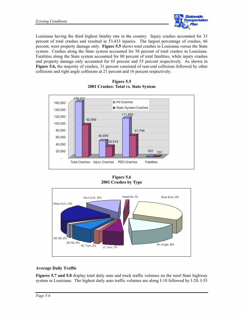
Louisiana having the third highest fatality rate in the country. Injury crashes accounted for 33 percent of total crashes and resulted in 53,433 injuries. The largest percentage of crashes, 66 percent, were property damage only. Figure 5.5 shows total crashes in Louisiana versus the State system. Crashes along the State system accounted for 58 percent of total crashes in Louisiana. Fatalities along the State system accounted for 80 percent of total fatalities, while injury crashes and property damage only accounted for 65 percent and 55 percent respectively. As shown in Figure 5.6, the majority of crashes, 31 percent consisted of rear-end collisions followed by other collisions and right angle collisions at 21 percent and 16 percent respectively.
Figure 5.5 2001 Crashes: Total vs. State System
Figure 5.6 2001 Crashes by Type
Average Daily Traffic
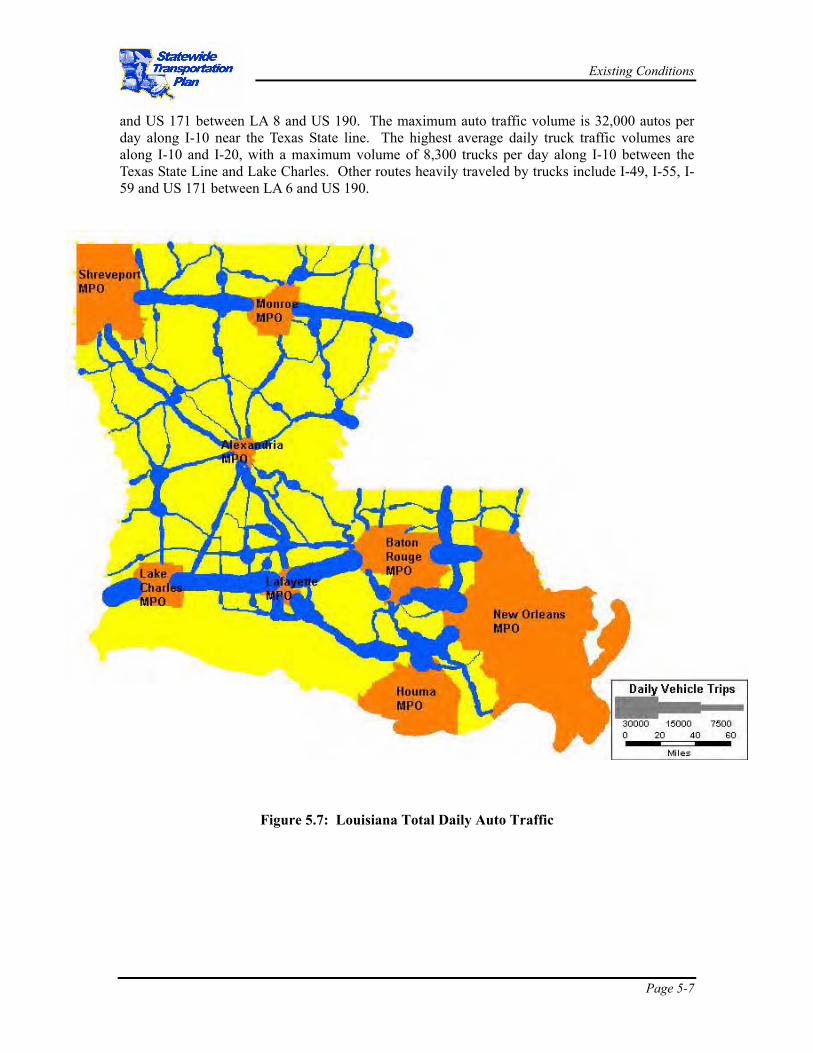
Figures 5.7 and 5.8 display total daily auto and truck traffic volumes on the rural State highway system in Louisiana. The highest daily auto traffic volumes are along I-10 followed by I-20, I-55
159,431
92,958
46,699
30,519
111,866
61,746
952 757
-
20,000
40,000
60,000
80,000
100,000
120,000
140,000
160,000
Total Crashes Injury Crashes PDO Crashes Fatalities
All Crashes
State System Crashes
Non-Coll., 12% Head-On, 1%
Rt. Angle, 16%Lt. Turn, 7%Rt. Turn, 2%
SD SS, 8%OD SS, 2%
Rear-End, 31%
Other Coll., 21%
Existing Conditions
Page 5-7
and US 171 between LA 8 and US 190. The maximum auto traffic volume is 32,000 autos per day along I-10 near the Texas State line. The highest average daily truck traffic volumes are along I-10 and I-20, with a maximum volume of 8,300 trucks per day along I-10 between the Texas State Line and Lake Charles. Other routes heavily traveled by trucks include I-49, I-55, I-59 and US 171 between LA 6 and US 190.
Figure 5.7: Louisiana Total Daily Auto Traffic

Existing Conditions
Page 5-8
Figure 5.8: Louisiana Total Daily Truck Traffic
0 20 40 60Miles
Daily Vehicle Trips
10000 5000 2500
ShreveportMPO
MonroeMPO
AlexandriaMPO
LakeCharlesMPO
BatonRougeMPO
New OrleansMPO
HoumaMPO
LafayetteMPO
Existing Conditions
Page 5-9
Level-Of-Service
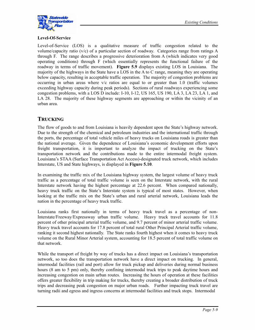
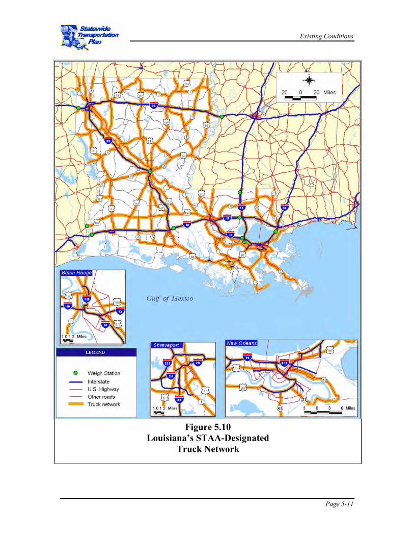
Level-of-Service (LOS) is a qualitative measure of traffic congestion related to the volume/capacity ratio (v/c) of a particular section of roadway. Categories range from ratings A through F. The range describes a progressive deterioration from A (which indicates very good operating conditions) through F (which essentially represents the functional failure of the roadway in terms of traffic movement). Figure 5.9 displays existing LOS in Louisiana. The majority of the highways in the State have a LOS in the A to C range, meaning they are operating below capacity, resulting in acceptable traffic operation. The majority of congestion problems are occurring in urban areas where v/c ratios are equal to or greater than 1.0 (traffic volumes exceeding highway capacity during peak periods). Sections of rural roadways experiencing some congestion problems, with a LOS D include: I-10, I-12, US 165, US 190, LA 3, LA 23, LA 1, and LA 28. The majority of these highway segments are approaching or within the vicinity of an urban area. TTRRUUCCKKIINNGG The flow of goods to and from Louisiana is heavily dependent upon the State’s highway network. Due to the strength of the chemical and petroleum industries and the international traffic through the ports, the percentage of total vehicle miles of heavy trucks on Louisiana roads is greater than the national average. Given the dependence of Louisiana’s economic development efforts upon freight transportation, it is important to analyze the impact of trucking on the State’s transportation network and the contributions made to the entire intermodal freight system. Louisiana’s STAA (Surface Transportation Act Access)-designated truck network, which includes Interstate, US and State highways, is displayed in Figure 5.10. In examining the traffic mix of the Louisiana highway system, the largest volume of heavy truck traffic as a percentage of total traffic volume is seen on the Interstate network, with the rural Interstate network having the highest percentage at 22.6 percent. When compared nationally, heavy truck traffic on the State’s Interstate system is typical of most states. However, when looking at the traffic mix on the State’s urban and rural arterial network, Louisiana leads the nation in the percentage of heavy truck traffic. Louisiana ranks first nationally in terms of heavy truck travel as a percentage of non-Interstate/Freeway/Expressway urban traffic volume. Heavy truck travel accounts for 11.8 percent of other principal arterial traffic volume, and 9.7 percent of minor arterial traffic volume. Heavy truck travel accounts for 17.8 percent of total rural Other Principal Arterial traffic volume, ranking it second highest nationally. The State ranks fourth highest when it comes to heavy truck volume on the Rural Minor Arterial system, accounting for 18.5 percent of total traffic volume on that network. While the transport of freight by way of trucks has a direct impact on Louisiana’s transportation network, so too does the transportation network have a direct impact on trucking. In general, intermodal facilities (rail and port) allow for truck pickup and deliveries during normal business hours (8 am to 5 pm) only, thereby confining intermodal truck trips to peak daytime hours and increasing congestion on main urban routes. Increasing the hours of operation at these facilities offers greater flexibility in trip making for trucks, thereby creating a broader distribution of truck trips and decreasing peak congestion on major urban roads. Further impacting truck travel are turning radii and egress and ingress concerns at intermodal facilities and truck stops. Intermodal
Existing Conditions
Page 5-10
Existing Conditions
Page 5-11
Figure 5.10 Louisiana’s STAA-Designated
Truck Network
Existing Conditions
Page 5-12
accessibility and mobility with respect to trucking will have a direct bearing on the efficiency of freight transport and subsequently contribute to the success of Louisiana’s economic development efforts. By creating a greater efficiency in truck travel through successful highway and intermodal planning, a positive impact on the State’s industrial recruitment and expansion efforts can be recognized. Truck Volumes
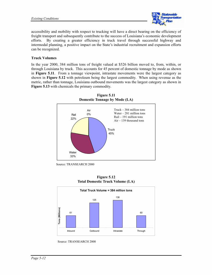
In the year 2000, 384 million tons of freight valued at $526 billion moved to, from, within, or through Louisiana by truck. This accounts for 45 percent of domestic tonnage by mode as shown in Figure 5.11. From a tonnage viewpoint, intrastate movements were the largest category as shown in Figure 5.12 with petroleum being the largest commodity. When using revenue as the metric, rather than tonnage, Louisiana outbound movements was the largest category as shown in Figure 5.13 with chemicals the primary commodity.
Figure 5.11 Domestic Tonnage by Mode (LA)
Source: TRANSEARCH 2000
Figure 5.12 Total Domestic Truck Volume (LA)
Source: TRANSEARCH 2000
Total Truck Volume = 384 million tons
61
125138
60
Inbound Outbound Intrastate Through
Tons
(Mill
ions
)
Truck45%
Water33%
Rail22%
Air0%
Truck – 384 million tons Water – 281 million tons Rail – 191 million tons Air – 139 thousand tons

Existing Conditions
Page 5-13
Figure 5.13 Total Domestic Truck Freight Value (LA)
Source: TRANSEARCH 2000
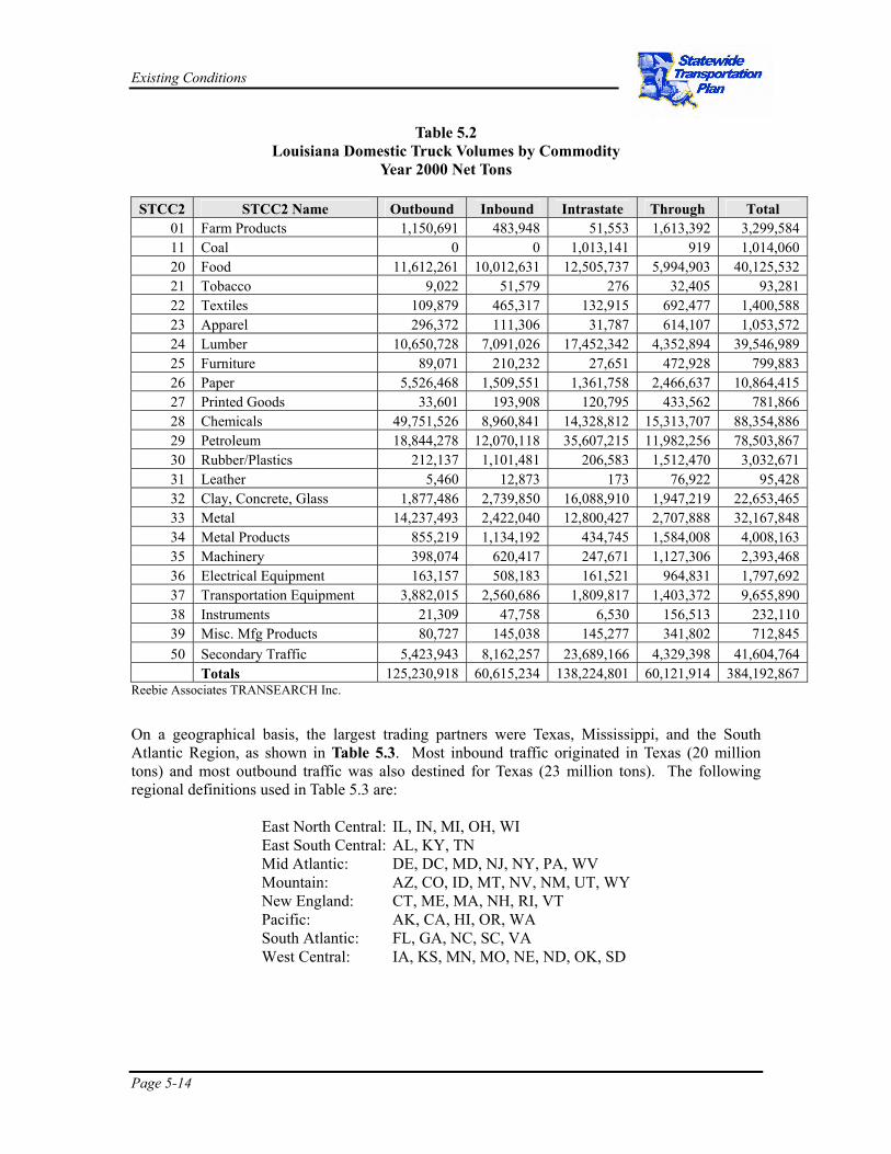
Table 5.2 breaks down the domestic truck tonnage by two-digit Standard Transportation Commodity Code (STCC) and traffic type. Chemicals (88 million tons) and petroleum (79 million tons) are the largest commodities, but also significant are secondary traffic (42 million tons), food (40 million tons), lumber (40 million tons), and metals (32 million tons). Secondary traffic refers to shipments from warehouses and distribution centers to the final customer, rather than direct shipments from factories. Chemicals are the largest outbound commodity, accounting for 40 percent of outbound truck tonnage. The two largest inbound commodities are petroleum (12 million tons) and food (10 million tons). The predominant intrastate truck movement is petroleum (36 million tons) followed by secondary traffic (24 million tons). The primary through traffic is also chemicals and petroleum.
$97
$172
$145
$112
Inbound Outbound Intra Through
Valu
e (B
illio
ns o
f $)
Total Truck Volume = $526 Billion
Existing Conditions
Page 5-14
Table 5.2 Louisiana Domestic Truck Volumes by Commodity
Year 2000 Net Tons
STCC2 STCC2 Name Outbound Inbound Intrastate Through Total 01 Farm Products 1,150,691 483,948 51,553 1,613,392 3,299,584 11 Coal 0 0 1,013,141 919 1,014,060 20 Food 11,612,261 10,012,631 12,505,737 5,994,903 40,125,532 21 Tobacco 9,022 51,579 276 32,405 93,281 22 Textiles 109,879 465,317 132,915 692,477 1,400,588 23 Apparel 296,372 111,306 31,787 614,107 1,053,572 24 Lumber 10,650,728 7,091,026 17,452,342 4,352,894 39,546,989 25 Furniture 89,071 210,232 27,651 472,928 799,883 26 Paper 5,526,468 1,509,551 1,361,758 2,466,637 10,864,415 27 Printed Goods 33,601 193,908 120,795 433,562 781,866 28 Chemicals 49,751,526 8,960,841 14,328,812 15,313,707 88,354,886 29 Petroleum 18,844,278 12,070,118 35,607,215 11,982,256 78,503,867 30 Rubber/Plastics 212,137 1,101,481 206,583 1,512,470 3,032,671 31 Leather 5,460 12,873 173 76,922 95,428 32 Clay, Concrete, Glass 1,877,486 2,739,850 16,088,910 1,947,219 22,653,465 33 Metal 14,237,493 2,422,040 12,800,427 2,707,888 32,167,848 34 Metal Products 855,219 1,134,192 434,745 1,584,008 4,008,163 35 Machinery 398,074 620,417 247,671 1,127,306 2,393,468 36 Electrical Equipment 163,157 508,183 161,521 964,831 1,797,692 37 Transportation Equipment 3,882,015 2,560,686 1,809,817 1,403,372 9,655,890 38 Instruments 21,309 47,758 6,530 156,513 232,110 39 Misc. Mfg Products 80,727 145,038 145,277 341,802 712,845 50 Secondary Traffic 5,423,943 8,162,257 23,689,166 4,329,398 41,604,764
Totals 125,230,918 60,615,234 138,224,801 60,121,914 384,192,867 Reebie Associates TRANSEARCH Inc.
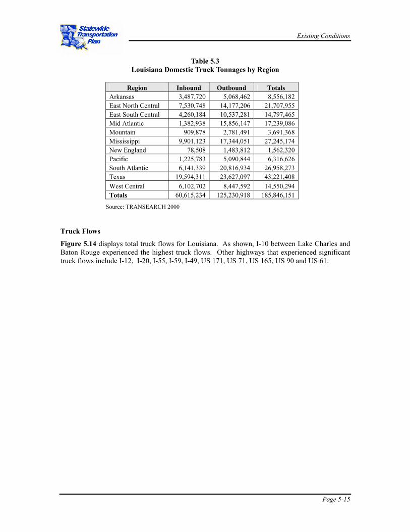
On a geographical basis, the largest trading partners were Texas, Mississippi, and the South Atlantic Region, as shown in Table 5.3. Most inbound traffic originated in Texas (20 million tons) and most outbound traffic was also destined for Texas (23 million tons). The following regional definitions used in Table 5.3 are:
East North Central: IL, IN, MI, OH, WI East South Central: AL, KY, TN Mid Atlantic: DE, DC, MD, NJ, NY, PA, WV Mountain: AZ, CO, ID, MT, NV, NM, UT, WY New England: CT, ME, MA, NH, RI, VT Pacific: AK, CA, HI, OR, WA South Atlantic: FL, GA, NC, SC, VA West Central: IA, KS, MN, MO, NE, ND, OK, SD
Existing Conditions
Page 5-15
Table 5.3 Louisiana Domestic Truck Tonnages by Region
Region Inbound Outbound Totals
Arkansas 3,487,720 5,068,462 8,556,182 East North Central 7,530,748 14,177,206 21,707,955 East South Central 4,260,184 10,537,281 14,797,465 Mid Atlantic 1,382,938 15,856,147 17,239,086 Mountain 909,878 2,781,491 3,691,368 Mississippi 9,901,123 17,344,051 27,245,174 New England 78,508 1,483,812 1,562,320 Pacific 1,225,783 5,090,844 6,316,626 South Atlantic 6,141,339 20,816,934 26,958,273 Texas 19,594,311 23,627,097 43,221,408 West Central 6,102,702 8,447,592 14,550,294 Totals 60,615,234 125,230,918 185,846,151
Source: TRANSEARCH 2000
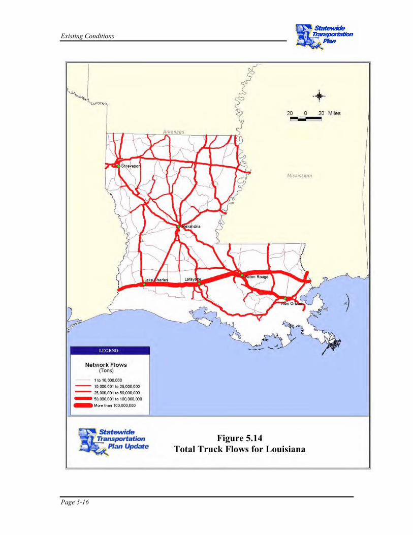
Truck Flows
Figure 5.14 displays total truck flows for Louisiana. As shown, I-10 between Lake Charles and Baton Rouge experienced the highest truck flows. Other highways that experienced significant truck flows include I-12, I-20, I-55, I-59, I-49, US 171, US 71, US 165, US 90 and US 61.
Existing Conditions
Page 5-16
Figure 5.14 Total Truck Flows for Louisiana

Existing Conditions
Page 5-17
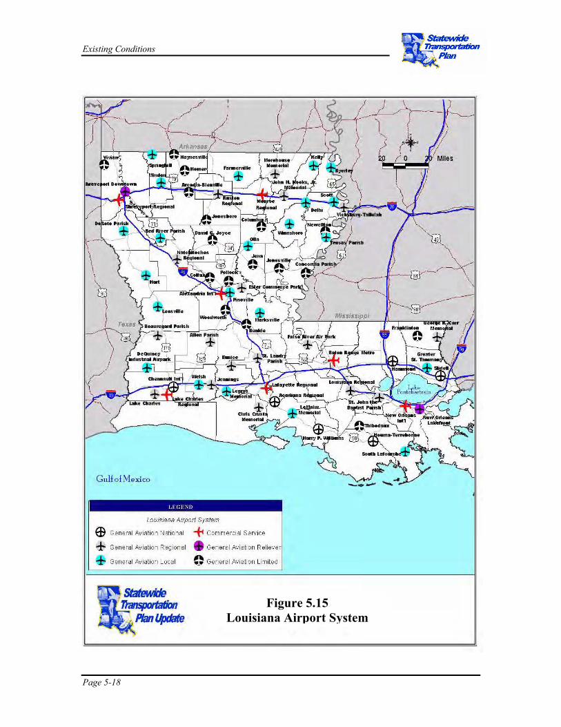
AAVVIIAATTIIOONN Louisiana has a broad system of airports throughout the State. There are 71 airports recognized by the Louisiana Department of Transportation and Development (DOTD) as system airports. These airports range in size and scope from large international airports serving commercial airlines to small turf strips accommodating aerial applicators and general aviation aircraft. These airports accommodate passenger, military, air cargo, and general aviation aircraft. There are 4,223 registered aircraft in the State and 7,254 registered pilots. Figure 5.15 identifies all public airports in the Louisiana system of airports.
There are several key issues in the aviation industry in Louisiana. These issues include runway development, development and retention of passenger service, development of international air service related to passengers and cargo, agricultural aviation issues, and whether a new, privately-financed, airport should be developed between Baton Rouge and New Orleans.
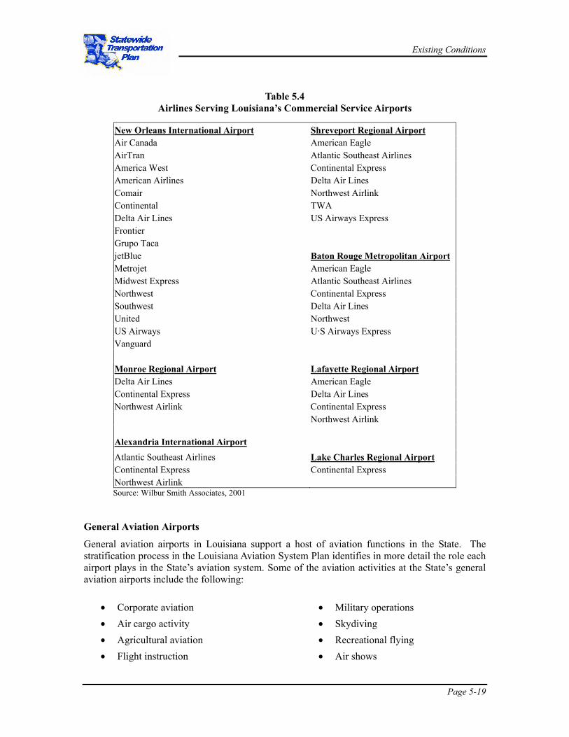
Current Air Service
Twenty-one passenger airlines serve Louisiana at seven commercial service airports. Table 5.4 identifies airlines serving Louisiana’s commercial service airports as of October, 2001. Air cargo is transported in and out of Louisiana on passenger aircraft and all-cargo aircraft. These aircraft are operated by airlines, all-cargo carriers, and integrated express operators.
Air cargo transport typically takes place at commercial service airports, but may on occasion occur on an ad hoc basis at general aviation airports. There are seven commercial service airports in the State:
• Alexandria International Airport
• Baton Rouge Metropolitan Airport
• Lake Charles Regional Airport
• Lafayette Regional Airport
• Louis Armstrong New Orleans International Airport
• Monroe Regional Airport
• Shreveport Regional Airport
Existing Conditions
Page 5-18
Figure 5.15 Louisiana Airport System
Figure 5.15 Louisiana Airport System
Existing Conditions
Page 5-19
Table 5.4
Airlines Serving Louisiana’s Commercial Service Airports
New Orleans International Airport Shreveport Regional Airport Air Canada American Eagle AirTran Atlantic Southeast Airlines America West Continental Express American Airlines Delta Air Lines Comair Northwest Airlink Continental TWA Delta Air Lines US Airways Express Frontier Grupo Taca jetBlue Baton Rouge Metropolitan Airport Metrojet American Eagle Midwest Express Atlantic Southeast Airlines Northwest Continental Express Southwest Delta Air Lines United Northwest US Airways U·S Airways Express Vanguard Monroe Regional Airport Lafayette Regional Airport Delta Air Lines American Eagle Continental Express Delta Air Lines Northwest Airlink Continental Express Northwest Airlink
Alexandria International Airport Atlantic Southeast Airlines Lake Charles Regional Airport Continental Express Continental Express Northwest Airlink Source: Wilbur Smith Associates, 2001
General Aviation Airports
General aviation airports in Louisiana support a host of aviation functions in the State. The stratification process in the Louisiana Aviation System Plan identifies in more detail the role each airport plays in the State’s aviation system. Some of the aviation activities at the State’s general aviation airports include the following:
• Corporate aviation • Air cargo activity • Agricultural aviation • Flight instruction
• Military operations • Skydiving • Recreational flying • Air shows

Existing Conditions
Page 5-20
• Medical evacuation • Organ transport • Forest firefighting • Real estate tours • Aerial photography
• Pipeline patrols • Oil rig support • Environmental mitigation • Civil Air Patrol • Search and rescue
There are 71 airports in the Louisiana Airport System Plan (LASP). Seven of these airports are commercial service airports and the remaining 64 are general aviation airports. Two of the general aviation airports are considered reliever airports. Reliever airports support aviation activity in large markets and are developed to encourage general aviation activity away from commercial service airports. The reliever airports and their associated cities include the following: • New Orleans Lakefront Airport New Orleans • Shreveport Downtown Airport Shreveport
Annual Passenger Enplanements
Table 5.5 displays annual passenger enplanements from 1991 to 2000. As shown the State’s market share of total US enplanements has decreased over the past nine years from 0.901 percent in 1991 to 0.890 percent in 2000. The average market share over the nine-year period is 0.893 percent.
Table 5.5 Annual Passenger Enplanements
Year
Louisiana All Airports
Enplanements
United States Total
Enplanements
Louisiana All Airports
Share Louisiana
Growth Rate 1991 4,405,968 489,154,800 0.901% - - 1992 4,478,490 510,598,100 0.877% 1.65% 1993 4,468,431 520,038,100 0.859% -0.22% 1994 5,035,873 562,059,200 0.896% 12.70% 1995 5,279,367 582,042,600 0.907% 4.84% 1996 5,490,944 613,637,400 0.895% 4.01% 1997 5,715,877 637,497,700 0.897% 4.10% 1998 5,879,754 649,125,600 0.906% 2.87% 1999 6,072,314 674,139,700 0.901% 3.27% 2000 6,287,718 706,106,300 0.890% 3.55%
Existing Conditions
Page 5-21
Air Cargo
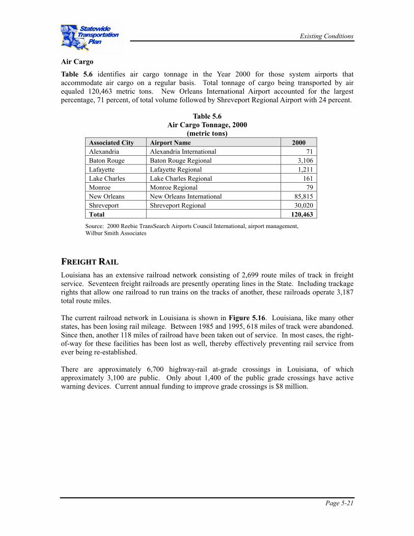
Table 5.6 identifies air cargo tonnage in the Year 2000 for those system airports that accommodate air cargo on a regular basis. Total tonnage of cargo being transported by air equaled 120,463 metric tons. New Orleans International Airport accounted for the largest percentage, 71 percent, of total volume followed by Shreveport Regional Airport with 24 percent.
Table 5.6
Air Cargo Tonnage, 2000 (metric tons)
Associated City Airport Name 2000 Alexandria Alexandria International 71 Baton Rouge Baton Rouge Regional 3,106 Lafayette Lafayette Regional 1,211 Lake Charles Lake Charles Regional 161 Monroe Monroe Regional 79 New Orleans New Orleans International 85,815 Shreveport Shreveport Regional 30,020 Total 120,463
Source: 2000 Reebie TransSearch Airports Council International, airport management, Wilbur Smith Associates
FFRREEIIGGHHTT RRAAIILL Louisiana has an extensive railroad network consisting of 2,699 route miles of track in freight service. Seventeen freight railroads are presently operating lines in the State. Including trackage rights that allow one railroad to run trains on the tracks of another, these railroads operate 3,187 total route miles. The current railroad network in Louisiana is shown in Figure 5.16. Louisiana, like many other states, has been losing rail mileage. Between 1985 and 1995, 618 miles of track were abandoned. Since then, another 118 miles of railroad have been taken out of service. In most cases, the right-of-way for these facilities has been lost as well, thereby effectively preventing rail service from ever being re-established. There are approximately 6,700 highway-rail at-grade crossings in Louisiana, of which approximately 3,100 are public. Only about 1,400 of the public grade crossings have active warning devices. Current annual funding to improve grade crossings is $8 million.

Existing Conditions
Page 5-22
Figure 5.16 Louisiana Rail System
Existing Conditions
Page 5-23
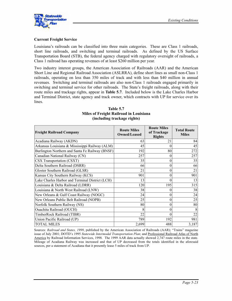
Current Freight Service
Louisiana’s railroads can be classified into three main categories. These are Class 1 railroads, short line railroads, and switching and terminal railroads. As defined by the US Surface Transportation Board (STB), the federal agency charged with regulatory oversight of railroads, a Class 1 railroad has operating revenues of at least $260 million per year.
Two industry interest groups, the American Association of Railroads (AAR) and the American Short Line and Regional Railroad Association (ASLRRA), define short lines as small non-Class 1 railroads, operating on less than 350 miles of track and with less than $40 million in annual revenues. Switching and terminal railroads are also non-Class 1 railroads engaged primarily in switching and terminal service for other railroads. The State’s freight railroads, along with their route miles and trackage rights, appear in Table 5.7. Included below is the Lake Charles Harbor and Terminal District, state agency and track owner, which contracts with UP for service over its lines.
Table 5.7 Miles of Freight Railroad in Louisiana
(including trackage rights)
Freight Railroad Company Route Miles Owned/Leased
Route Miles of Trackage
Rights
Total Route Miles
Acadiana Railway (AKDN) 63 21 84 Arkansas Louisiana & Mississippi Railway (ALM) 45 0 45 Burlington Northern and Santa Fe Railway (BNSF) 192 80 272 Canadian National Railway (CN) 257 0 257CSX Transportation (CSXT) 35 0 35Delta Southern Railroad (DSRR) 66 0 66Gloster Southern Railroad (GLSR) 21 0 21 Kansas City Southern Railway (KCS) 901 0 901 Lake Charles Harbor and Terminal District (LCH) 13 0 13Louisiana & Delta Railroad (LDRR) 120 195 315 Louisiana & North West Railroad (LNW) 38 0 38 New Orleans & Gulf Coast Railway (NOGC) 24 0 24 New Orleans Public Belt Railroad (NOPB) 25 0 25 Norfolk Southern Railway (NS) 80 0 80 Ouachita Railroad (OUCH) 8 0 8 TimberRock Railroad (TIBR) 22 0 22 Union Pacific Railroad (UP) 789 192 981 TOTAL MILES 2,699 488 3,187
Sources: Railroad and States, 1999, published by the American Association of Railroads (AAR); “Trains” magazine issue of July 2001; DOTD’s 1995 Statewide Intermodal Transportation Plan; and Professional Railroad Atlas of North America by Railroad Information Services, 1998. The 1999 AAR data actually showed 2,747 route miles in the state. Mileage of Acadiana Railway was increased and that of UP decreased from the totals identified in the aforesaid sources, per a statement of Acadiana that it presently lease 5 miles of track from UP.

Existing Conditions
Page 5-24
Class 1 Railroads
As shown in Figure 5.16, there are six Class 1 railroads serving Louisiana, operating over 2,526 miles of railroad, including trackage rights. New Orleans is a major interchange point or gateway for western railroads UP and BNSF and eastern railroads CSXT and NS. All of the Class 1 railroads connect in New Orleans, either individually or through the switching services of the New Orleans Public Belt Railroad. Likewise, they all serve the Port of New Orleans.
The traffic densities on these lines, shown in ranges of millions of gross ton-miles per mile (MGTM/M) for the most recent year available, appear in Figure 5.17 (MGTM/M is the common railroad measure of traffic activity on specific line segments). Lines handling more than 40 MGTM/M can be considered very busy lines. On the other hand, those handling less than 5 MGTM/M are known as light density lines, according to the Federal Railroad Administration (FRA).
Short Line & Switching and Terminal Railroads:
There are nine local or short line railroads in Louisiana, operating 661 miles of railroad, including trackage rights. There are two switching and terminal railroads in Louisiana, operating a total of 38 route miles of railroad.
Freight Traffic
Total rail freight traffic in Louisiana in 1999 was comprised of 119.4 million tons as shown in Table 5.8. Out of the total, 37.1 million tons originated in the State with destinations outside of the State, and 31.5 million tons terminated in the State from origins outside of the State. There were 4.9 million tons which originated and terminated within Louisiana; that is, freight traffic that remains within the State (intrastate traffic). Through traffic (traffic passing through without an origin or destination in Louisiana) accounted for 45.9 million tons. Together, the commodities shown in the table below account for almost 98 percent of all rail shipments to, from, within and through the State.
Table 5.8 Louisiana Freight Traffic, 1999
Commodity Tonnage
STCC Description Originat’g Terminat’g Intrastate Through Total % Total28 Chemicals or allied products 10,957,661 2,542,499 1,990,783 13,802,101 29,293,044 24.5%49 Hazardous materials 8,841,553 1,695,154 1,231,861 9,080,788 20,849,356 17.5%01 Farm products 476,869 6,585,678 8,630 2,124,069 9,195,246 7.7%46 Miscellaneous mixed shpmts. 4,072,584 3,738,181 640 1,326,799 9,138,203 7.7%11 Coal 4,242,394 4,739,836 8,982,230 7.5%26 Pulp, paper, or allied products 4,340,667 525,566 305,167 2,923,821 8,095,221 6.8%20 Food or kindred products 1,580,049 2,354,773 110,679 2,286,834 6,332,336 5.3%29 Petroleum or coal products 2,015,218 737,325 679,706 2,184,621 5,616,869 4.7%14 Non metallic minerals 97,805 4,020,622 7,920 503,674 4,630,022 3.9%24 Lumber or wood products 1,777,220 953,384 272,867 1,022,015 4,025,486 3.4%33 Primary metal products 794,816 358,637 15,332 2,338,365 3,507,150 2.9%32 Clay, concrete, glass, stone prod. 478,615 1,040,913 14,683 1,457,819 2,992,029 2.5%37 Transportation equipment 708,941 1,407,319 142,545 376,628 2,635,434 2.2%40 Waste or scrap materials 298,016 568,760 29,762 601,334 1,497,872 1.3%
All others 647,675 681,719 132,648 1,109,264 2,571,306 2.2% Total 37,087,690 31,452,924 4,943,223 45,877,968 119,361,805 100.0%
Source: STB Waybill Sample compiled by Wilbur Smith Associates.

Existing Conditions
Page 5-25
Figure 5.17 Louisiana Rail Line Density

Existing Conditions
Page 5-26
Commodities and Flows
In the aggregate (all movement types), chemicals or allied products comprise the largest commodity moving by rail (24.5 percent) in or through Louisiana. Hazardous materials are second at 17.5 percent (probably chemicals in large part). Three commodity types – farm products (grains including wheat, corn, and soybeans), mixed shipments (intermodal trailers and containers), and coal – each account for about 8 percent of rail totals. Pulp, paper, and allied products make up 6.8 percent of Louisiana rail traffic.
The significance of each commodity varies, however, by movement type. The following paragraphs elaborate on the differences.
Originating Traffic
The 37.1 million tons of commodities originating by rail in Louisiana, and terminating outside the State, are comprised principally by four groups:
• Chemicals or allied products (29.5 percent)
• Hazardous materials (23.8 percent)
• Pulp, paper, or allied products (11.7 percent)
• Miscellaneous mixed shipments (11.0 percent).
Together the commodity shipments above embrace more than three-fourths of the originating total. Other significant outbound commodities include petroleum or coal products at 5.4 percent, food or kindred products (e.g., frozen foods, beer, etc.) at 4.3 percent, and lumber and wood products at 4.8 percent.
Rail freight originating in Louisiana predominantly terminates in Texas, as shown in Figure 5.18. The next largest areas are California, Illinois, Georgia and Florida. Combined, these states account for 18.1 million tons or 48.7 percent of originating Louisiana volumes. The shipments to California are largely intermodal, chemicals and pulp/paper products. Traffic to Florida is mostly intermodal and hazardous material, as are the largest shipments to Illinois and Texas.
Terminating Traffic
Nine commodity types dominate tonnage terminating by rail in Louisiana and originating by rail outside the State. They are a diverse group, comprised of the following, which account for almost 88 percent of total terminating shipments.
• Farm products at 20.9 percent
• Coal at 13.5 percent
• Non-metallic minerals at 12.8 percent
• Miscellaneous mixed shipments (intermodal containers and trailers) at 11.9 percent
• Chemicals or allied products at 8.0 percent
• Food or kindred products at 7.5 percent
• Hazardous materials at 5.4 percent
• Transportation equipment at 4.5 percent
• Clay, concrete, glass or stone products at 3.3 percent
Existing Conditions
Page 5-27
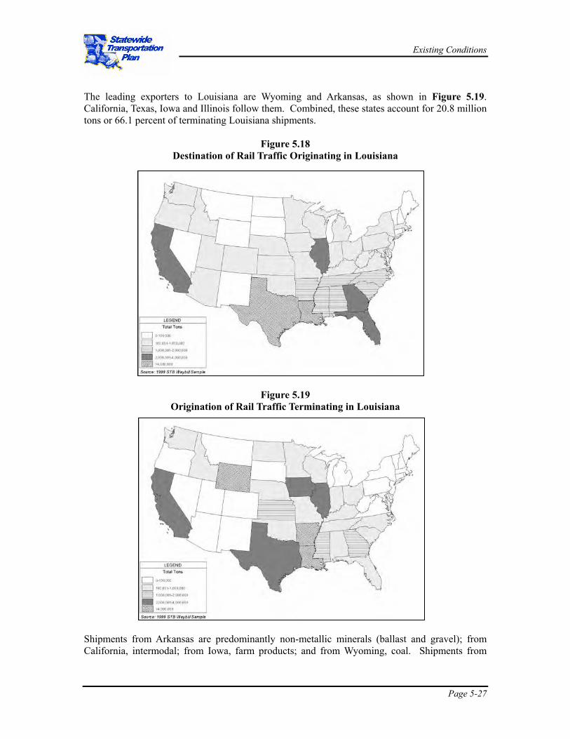
The leading exporters to Louisiana are Wyoming and Arkansas, as shown in Figure 5.19. California, Texas, Iowa and Illinois follow them. Combined, these states account for 20.8 million tons or 66.1 percent of terminating Louisiana shipments.
Figure 5.18 Destination of Rail Traffic Originating in Louisiana
Figure 5.19
Origination of Rail Traffic Terminating in Louisiana
Shipments from Arkansas are predominantly non-metallic minerals (ballast and gravel); from California, intermodal; from Iowa, farm products; and from Wyoming, coal. Shipments from

Existing Conditions
Page 5-28
Texas are more varied than from these other states, but over half are chemicals and hazardous materials.
Intrastate Traffic
Louisiana intrastate traffic – traffic that both originated and terminated in Louisiana – totaled 4.9 million tons in 1999. This sum is small compared to the other types of movements which is logical since rail is not conducive to short distance movements under most circumstances.
Through Commodities
Rail traffic passing through Louisiana from origins outside of the State and destined for delivery in states other than Louisiana comprise the largest rail traffic movement at 45.9 million tons.
Traffic History
As shown in Figure 5.20, total freight traffic in the 10 years between 1990 and 1999 increased 40 percent. Traffic volumes dropped slightly in 1997, presumably due to the service problems on the Union Pacific Railroad, but recovered in 1998. Growth over the following year topped 5.7 percent.
Figure 5.20 Louisiana Freight Traffic History
PPOORRTTSS && WWAATTEERRWWAAYYSS The network of ports and navigable waterways in Louisiana is an important component of the intermodal freight transportation infrastructure. In terms of physical infrastructure it includes the navigable waterways, shallow- and deep-draft ports and intermodal connections serving waterfront activities, and the vessel fleet operating on the network. On a functional basis, it can essentially be defined as two subsystems: an inland barge transportation system engaged primarily in domestic commerce; and a deep-draft ports system providing access to international markets through the Gulf of Mexico.
Navigable Network
Louisiana is located at the intersection of the two largest waterway networks, the Mississippi River System and the Gulf Intra-Coastal Waterway, comprising 86 percent of the national network in terms of length and 97 percent of the system’s overall tonnage. Therefore, the water transportation system provides accessibility to a large hinterland including states in the Midwest
020,000,00040,000,00060,000,00080,000,000
100,000,000120,000,000140,000,000
1990 1994 1995 1996 1997 1998 1999
Tons
Originat’gTerminat’gIntrastateThroughTotal Tons
Existing Conditions
Page 5-29
and the Gulf Coast. These highly developed transportation systems with heavy traffic are efficient modes of transportation with increasing economies of scale, especially for low-value, high-volume bulk cargoes. As a result, a large number of multinational businesses engaged in foreign commerce, petrochemical industries, shipbuilding and many other value-added industrial activities are located at the waterfront.
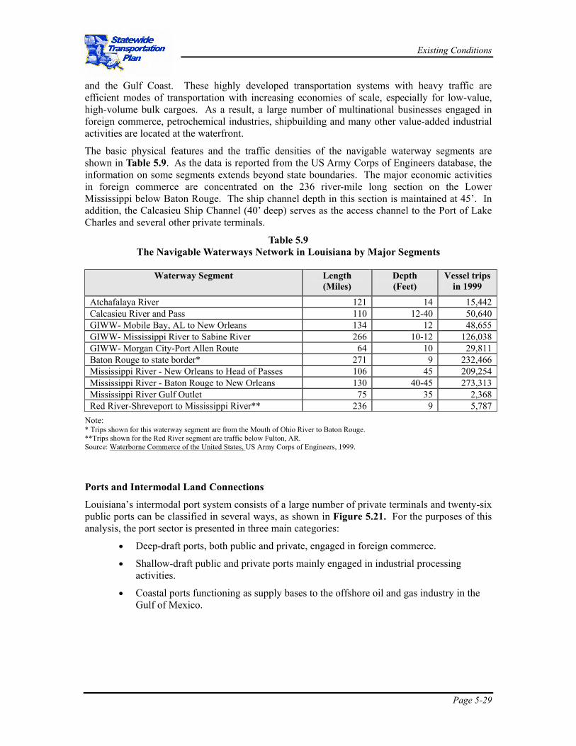
The basic physical features and the traffic densities of the navigable waterway segments are shown in Table 5.9. As the data is reported from the US Army Corps of Engineers database, the information on some segments extends beyond state boundaries. The major economic activities in foreign commerce are concentrated on the 236 river-mile long section on the Lower Mississippi below Baton Rouge. The ship channel depth in this section is maintained at 45’. In addition, the Calcasieu Ship Channel (40’ deep) serves as the access channel to the Port of Lake Charles and several other private terminals.
Table 5.9 The Navigable Waterways Network in Louisiana by Major Segments
Waterway Segment Length
(Miles) Depth (Feet)
Vessel trips in 1999
Atchafalaya River 121 14 15,442 Calcasieu River and Pass 110 12-40 50,640 GIWW- Mobile Bay, AL to New Orleans 134 12 48,655 GIWW- Mississippi River to Sabine River 266 10-12 126,038 GIWW- Morgan City-Port Allen Route 64 10 29,811 Baton Rouge to state border* 271 9 232,466 Mississippi River - New Orleans to Head of Passes 106 45 209,254 Mississippi River - Baton Rouge to New Orleans 130 40-45 273,313 Mississippi River Gulf Outlet 75 35 2,368 Red River-Shreveport to Mississippi River** 236 9 5,787
Note: * Trips shown for this waterway segment are from the Mouth of Ohio River to Baton Rouge. **Trips shown for the Red River segment are traffic below Fulton, AR. Source: Waterborne Commerce of the United States, US Army Corps of Engineers, 1999.
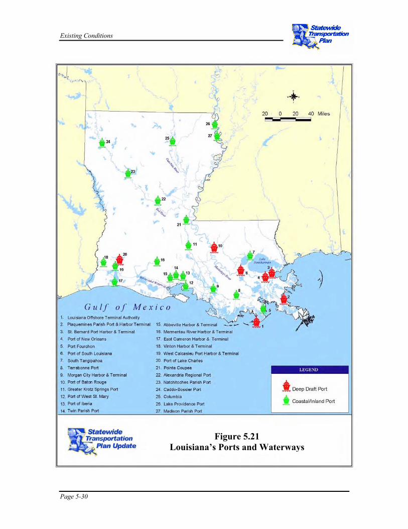
Ports and Intermodal Land Connections
Louisiana’s intermodal port system consists of a large number of private terminals and twenty-six public ports can be classified in several ways, as shown in Figure 5.21. For the purposes of this analysis, the port sector is presented in three main categories:
• Deep-draft ports, both public and private, engaged in foreign commerce.
• Shallow-draft public and private ports mainly engaged in industrial processing activities.
• Coastal ports functioning as supply bases to the offshore oil and gas industry in the Gulf of Mexico.
Existing Conditions
Page 5-30
Figure 5.21 Louisiana’s Ports and Waterways

Existing Conditions
Page 5-31
Deep Draft Ports
All maritime terminals on the Lower Mississippi River segment (including MRGO) and the Calcasieu Ship Channel fall into this category. In general, the navigable waterway segments with more than 25’ in depth are regarded as deep-draft port terminals. The five deep draft public ports located on the waterway segment from Baton Rouge to Head of Passes are among the largest in the nation in terms of tonnage handled. A large number of private terminals operating in each public port area are primarily responsible for this performance. The tonnage shown in Table 5.10 includes cargo handled at public as well as private terminals. The private sector contribution to the total tonnage comes from cargo such as grains and coal exports, as well as crude petroleum imports.
The privately owned and operated port terminals are typically dedicated to handle one type of cargo such as grains and coal export terminals and crude petroleum import terminals. These terminals are mostly under the management of multi-national firms with vertically integrated operations (e. g., grain buying at farm level, cleaning, blending for export and loading for shipping).
The cargo handling activities are highly automated using state of the art equipment, with scale economies. Consequent to the recent increases in steel imports, several mid-stream terminals exhibiting similar characteristics have developed, transferring cargo direct from ship to barges in large volumes.
The private sector operators also lease public port facilities, and manage bulk cargo terminals, general cargo and container berths at public ports. The role of public ports is mainly to function as ‘landlord’ ports supplying port facilities to the private sector and engaging in port marketing and promotion activities.
Table 5.10 Deep-Draft Ports in Louisiana, Tonnages Handled,
and National Ranking in 1999 (000 tons)
Port Total Imports Exports Rank South Louisiana 214,197 29,407 65,336 1 New Orleans 87,511 29,187 19,722 4 Baton Rouge 63,729 13,331 7,074 7 St. Bernard 538 191 347 --- Plaquemines 62,461 12,839 9,011 8 Lake Charles 50,742 27,001 3,751 13
Source: Waterborne Commerce of the United States, Part 5-National Summaries, US Army Corps of Engineers, 1999 Grain Export Elevators
During the 1990s farm products were responsible for more than one third of the total tonnage handled, about 79 million tons handled in 1999.
The grain exports from Louisiana are handled by land-based export elevators, by floating rigs located mid-river and by direct transfer from barges to ocean vessels. The essential difference is that the land-based elevators have the added capability of performing two important value-added activities: grain blending and grain storage.
Except for the public grain elevator at the Port of Lake Charles, all other grain export elevators are located on the Lower Mississippi River. The concentration of thirteen of them on a 75-mile

Existing Conditions
Page 5-32
stretch of the River is partly related to the fleeting operations of barges. The land-based grain elevators are complete facilities with long-term storage and highly automated grain-conveying systems.
Coal Terminals
Coal is a major commodity transported on the Lower Mississippi contributing on the average 10 to 12 percent of the total waterborne tonnage. The transportation of coal in Louisiana is primarily for three purposes: for local use at electric utilities and industrial plants, through traffic in transit from producing states to consumption states, and coal shipments for export.
Export volumes of coal in the 1990s were too low to utilize the full capacity of major coal export terminals. Fortunately, as the designs of these terminals are suitable for handling other dry-bulk cargos, a gradual diversification of the cargo base ensued from coal to pig iron, barite, cement, steel billets, etc. For example, IMT terminal, where the coal to other cargo ratio was 70:30 percent in the 1980’s, diversified its cargo base to a ratio of 45:55 in 1999, making the coal tonnage less than the other cargo.
Break-bulk and Neo-bulk Terminals
The container, break-bulk and neo-bulk cargos are broadly identified as general cargo. The differences among these categories are: container cargo is in standardized steel containers and measured in twenty-foot equivalent units (TEU); break-bulk cargo can be described as conventional packaged goods, and neo-bulk cargos are large consignments of loose cargo such as steel billets, steel wire coils, sawn timber etc. The classification is important from a cargo handling perspective as port infrastructure requirements and operations will be very different to the requirements for handling bulk cargo.
A functional classification of cargo handled by Louisiana ports in 1999 indicates that 8.6 percent of the tonnage handled falls into this category, with break-bulk and neo-bulk comprising close to 20 million tons, about equally divided between public and private terminals. The typical terminal design for handling general cargo consists of alongside a ship-berth, transit sheds and yard space for storage, and cranes and other cargo handling equipment. Five deep-draft ports in Louisiana (except Port of Plaquemine) have facilities to handle break-bulk and neo-bulk cargo. The Ports of New Orleans and Lake Charles handle more than 98 percent of the cargo. A substantial part of this cargo consists of steel billets and coils of wire directly transferred from ship to barges.
Large shipments of steel imports made in the latter part of the 1990’s contributed to rapid growth of neo-bulk cargo. Between 1992/1994 and 1997/1999 the tonnage handled doubled. In addition to the cargo that is handled at public terminals, several mid-river rigs also handle steel products. As most steel products need covered storage, the majority of the shipments are directly transferred from ship to barge or rail wherever possible. The break-bulk and neo-bulk terminals are multipurpose terminals that can adapt to a variety of operations.
Shallow-Draft Ports
There are twenty shallow-draft ports either located on inland waterways or on the coast serving mainly as industrial sites for water-related industries, and servicing the offshore oil and gas industry in the Gulf of Mexico. These ports vary in size, with Port Fourchon and the Port of Iberia generating large economic impacts as bases for the offshore oil and gas industry.
Most shallow-draft ports function as industrial parks for water related industries and facilitate diversification of the local economy and the creation of jobs in rural communities with limited opportunities. The performance evaluation of these ports cannot be gauged by a single index
Existing Conditions
Page 5-33
such as the volume of cargo tonnage handled or the amount of revenue generated. It requires a complex process of evaluation involving economic, social and regional growth factors.
Ports Serving OCS
Louisiana is the nation’s second largest producer of natural gas and third largest producer of crude oil among the 50 states. In terms of offshore oil and gas production, the Gulf of Mexico accounts for more than 90 percent of the US production. Three major public ports, Port Fourchon, Iberia and Morgan City and a large number of private terminals operate as supply bases to this fast growing offshore oil and gas industry in the State. Commercial fishing and recreational boating activities are much less important than other port activities. The rapid growth in oil and gas activities has imposed pressures on the limited public infrastructure facilities in the region. For example, southbound truck traffic to Port Fourchon has grown by 47 percent in a four-year period and inland waterway traffic by 24 percent. The cargo volumes handled at the port have increased by 127 percent in three years. According to the data maintained by the port, in 1999 the main access channel from the port to the Gulf was utilized by 56,918 vessel transits. Similar growth trends can be observed at the Port of Morgan City and at the Port of Iberia. SSUURRFFAACCEE PPAASSSSEENNGGEERR The Louisiana Department of Transportation and Development is working with both users and providers of our existing surface passenger transportation systems to develop a comprehensive and equitable transportation service delivery network that addresses this important component of the State’s overall transportation system. Surface passenger includes passenger rail, intercity bus and the local transit systems.
Private Intercity Motorcoach Carriers
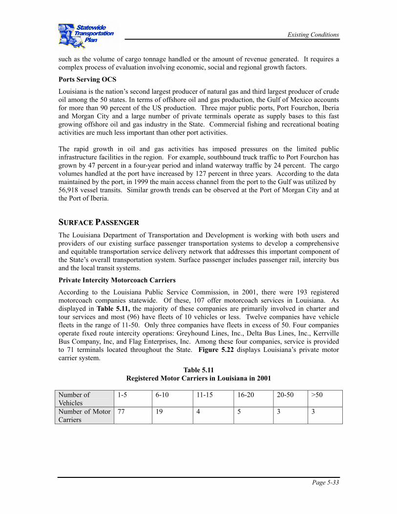
According to the Louisiana Public Service Commission, in 2001, there were 193 registered motorcoach companies statewide. Of these, 107 offer motorcoach services in Louisiana. As displayed in Table 5.11, the majority of these companies are primarily involved in charter and tour services and most (96) have fleets of 10 vehicles or less. Twelve companies have vehicle fleets in the range of 11-50. Only three companies have fleets in excess of 50. Four companies operate fixed route intercity operations: Greyhound Lines, Inc., Delta Bus Lines, Inc., Kerrville Bus Company, Inc, and Flag Enterprises, Inc. Among these four companies, service is provided to 71 terminals located throughout the State. Figure 5.22 displays Louisiana’s private motor carrier system.
Table 5.11 Registered Motor Carriers in Louisiana in 2001
Number of Vehicles
1-5 6-10 11-15 16-20 20-50 >50
Number of Motor Carriers
77 19 4 5 3 3
Existing Conditions
Page 5-34
Figure 5.22 Statewide Private Motor Carrier System (FY 00)

Existing Conditions
Page 5-35
Passenger Rail System
Current Amtrak Service
The State is served by three long distance Amtrak trains, centered on New Orleans: The Sunset Limited, The City of New Orleans and The Crescent. There currently is no commuter or intercity corridor service provided in the State, either by Amtrak or by other operators. Rail lines used for current and proposed Amtrak services are shown in Figure 5.23.
Proposed Services
Amtrak has evaluated a series of proposals that are designed to increase markets served and to improve the economic performance of its long distance routes. Termed the Network Growth Strategy (NGS), Amtrak has identified two proposals that affect service in Louisiana.
Crescent Star
Amtrak is pursuing plans to establish a new rail link between Meridian, Mississippi and Fort Worth, Texas. The service would involve splitting the Crescent at Meridian, and operating a segment of the train from Meridian to Dallas/Fort Worth via Jackson and Shreveport. The remainder of the Crescent would continue to New Orleans, as it presently does.
Sunset Limited
A second NGS proposal potentially affecting Louisiana is a long-range plan to reroute the Sunset Limited between Houston and El Paso to operate through Dallas, Fort Worth, Abilene, and Odessa instead of the current route through San Antonio and Alpine.
Gulf Coast High Speed Rail
The Transportation Equity Act for the 21st Century (TEA-21; Section 1103 (c)) directed the US Secretary of Transportation to designate federally recognized emerging high-speed rail corridors. The proposed Gulf Coast High Speed Rail Corridor was defined in an FRA and Louisiana funded study conducted in 1997 for the Southern Rapid Rail Transit Commission, a group representing the three states (LA, AL, MS) fostering high-speed rail travel in the Gulf Coast Region. This federally designated corridor (circa 1998) extends east/west between Houston, New Orleans, Gulfport/Biloxi, and Mobile with a possible future extension across the Florida panhandle to Jacksonville. It also extends northeasterly from New Orleans through Meridian, Tuscaloosa and Birmingham, ultimately connecting to the East Coast High Speed Rail Corridor extension in Atlanta.

Existing Conditions
Page 5-36
Figure 5.23 Lines with Passenger Rail Service

Existing Conditions
Page 5-37
Louisiana Rail Passenger Stations
Amtrak currently serves seven stations in Louisiana that account for almost 200,000 annual boarding and alighting passengers. Recent ridership data are shown in Table 5.12 below.
Table 5.12
Annual Amtrak Patronage For Louisiana Stations
Station 1999 2000 New Orleans 171,298 177,824 Hammond 9,078 11,178 Slidell 4,345 4,483 Lake Charles 2,352 2,320 Lafayette 2,591 2,215 New Iberia 1,062 1,060 Schriever 480 446
Source: Amtrak Quarterly Station Reports
Public Transit
The elderly, poor, and handicapped are considered the “non-auto, transportation disadvantaged” users. These are the most likely users of the states’ and nation’s non-auto, surface passenger transportation systems. Many elderly persons are retired, have low incomes, and suffer from physical disabilities. Automobile ownership is much lower among the poor than among higher-income groups. The handicapped as a group have lower employment rates, lower incomes, and are often afflicted by mobility problems. These represent the primary users of surface passenger transportation alternatives: transit, passenger rail, and intercity bus carriers. An overview of public transportation users in Louisiana and the US is provided in Table 5.13. Louisiana has a higher percentage of persons living in poverty, 19.6 percent, compared to the national average of 12.4 percent. The disabled population (ages 21-64) in the State comprised 22.1 percent of the population, which is slightly higher that the national average of 19.2 percent. The elderly comprised 11.6 percent of the State’s total population. Dependency on public transportation is far from uniform across geographical areas. The transit dependency of the transportation disadvantaged is much larger in the largest Metropolitan Statistical Areas (urban areas), but dramatically lower in rural areas or areas with lower density.
Table 5.13 Overview of Public Transportation Users, 2000
Louisiana USA Population 4,468,976 281,421,906 Below Poverty Line 851,113
(19.6%) 33,899,812 (12.4%)
Age 65 and Over 516,929 (11.6%)
34,991,753 (12.4%)
Disabled Population (age 21-64)
540,838 (22.1%)
30,553,796 (19.2%)
Mobility Impaired Aged 16-64 (1990 Census)
77,118 (2.99%)
3,793,697 (2.41%)

Existing Conditions
Page 5-38
Louisiana USA Households with no vehicle available
196,305 (11.9%)
10,861,067 (10.3%)
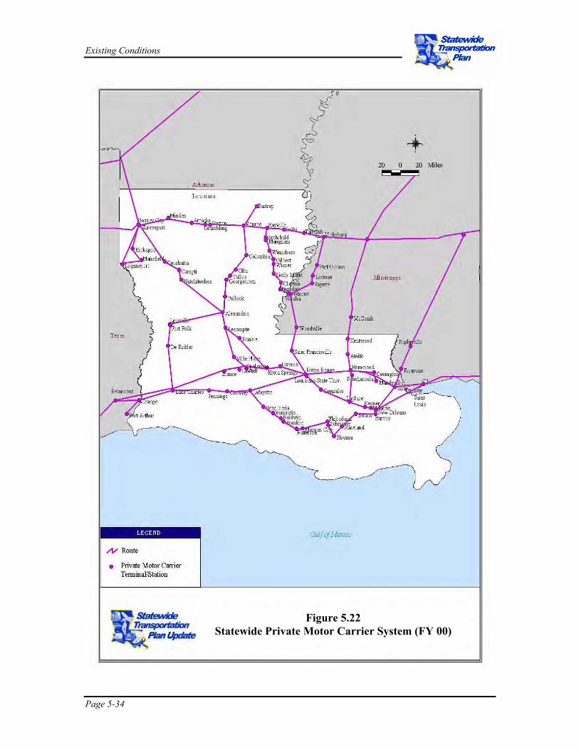
Public transit is provided in both urban and rural areas of the State. Currently 35 parishes have an urban and/or rural system, 10 parishes have an urban system, 29 parishes have a rural system and four parishes have both an urban and rural system. Twenty-nine parishes have no transit system. Urban systems include fixed route bus, streetcar (Orleans Parish only), and demand responsive services. There are currently 121 providers being funded by FTA funds for demand responsive services in both rural and elderly / disabled categories. One or more of these service types is present in all but 6 parishes within the State: Beauregard, Grant, Union, Vermon, West Caroll and Plaquemines. It was mutually agreed by both DOTD and consultant team that FY 1999 public transit data would be used throughout this report, as that is the most current year that includes all relevant data. The statewide public transportation system is displayed in Figure 5.24. BBIICCYYCCLLEE AANNDD PPEEDDEESSTTRRIIAANN Historically, bicycle and pedestrian modes have received comparatively little emphasis in Louisiana, as a result of the magnitude of needs in other modes. However, bicycling and walking are becoming more prominent modes, due in part to mandates from ISTEA and TEA-21 legislation to incorporate bicycle and pedestrian issues into statewide transportation planning.
In Louisiana, bicycle and pedestrian concerns are treated mainly as local issues; however, several initiatives at DOTD are enhancing the State’s role in bicycle and pedestrian planning. There are a number of opportunities to build upon these initiatives, through the development of policies related to bicycle and pedestrian improvements, expanding partnerships with other local and state organizations interested in bicycle and pedestrian concerns, and potential facilities improvements.
Existing Facilities
Several dedicated bicycle / pedestrian facilities are in place or under construction in Louisiana, mostly in the form of dedicated pathways. The Tammany Trace Trail, in St. Tammany Parish, is Louisiana’s first rail trail. A significant portion has already been completed, and the entire trail will be over 30 miles long when finished. The trail includes an innovative tunnel under a U.S. highway. A multi-use trail is also being constructed along the top of the Mississippi River levees in the New Orleans area. The paved trail will be 10 feet wide and presents a significant safety improvement for bicyclists, who previously had to use the adjacent River Road, which has a high volume of truck traffic and is prone to flooding. The trail will be approximately 40 miles long when complete, and will extend through several parishes. DOTD has also improved shoulders along existing roadways to create a better environment for bicyclists. Examples of shoulder improvements can be found along the roadways that comprise the Mississippi River Trail.
At the local level, many cities and towns have benefited from dedicated bicycle and pedestrian facilities funded through the federal Transportation Enhancements program.
Existing Conditions
Page 5-39
Figure 5.24 Statewide Public Transportation System
(FY 99)
with No Service
Existing Conditions
Page 5-40
IINNTTEELLLLIIGGEENNTT TTRRAANNSSPPOORRTTAATTIIOONN SSYYSSTTEEMMSS In recent years the DOTD has made significant progress towards a statewide, integrated approach to the implementation of Intelligent Transportation Systems (ITS) in Louisiana. The development of the Louisiana ITS program has been a coordinated effort involving numerous governmental transportation agencies. ITS is a tool for the active management of roadway operations. ITS is comprised of communication networks, computer monitoring and field control devices. These components include cameras, vehicle sensors, variable message signs, highway advisory radio communications, etc. that are common features of modern roadway networks. ITS components in conjunction with traffic management strategies are applied in an integrated manner to improve the operation and safety of transportation networks.
The Louisiana ITS program is a cooperative effort between federal, state, and local transportations agencies, the Metropolitan Planning Organizations (MPOs) and private organizations. The ITS program employs technology and process based initiatives to improve the overall operation of the State’s transportation system.
Louisiana transportation agencies are focusing their efforts in two distinct and overlapping ITS program applications. The first is traffic management systems to improve traveler mobility, reduce traffic congestion and improve transportation safety. Traffic management activities typically focus on, and have their greatest benefits in, major urban areas. The second is commercial vehicle operations (CVO). CVO ITS technologies are used to automate the permitting and documentation processes, increase the efficiency and effectiveness of vehicle and cargo inspections, and improve the overall safety of truck operations.
The framework for implementing ITS in the State is reflected in three ITS-related business plans sponsored by DOTD. They are:
• Louisiana ITS Business Plan
• Louisiana CVO/ITS Business Plan
• Louisiana CVISN Business Plan
Louisiana ITS Business Plan - 2000
Louisiana’s ITS Business Plan is broad in scope and provides a long-term strategic vision and program of projects to assist the State in integrating ITS applications into its surface transportation planning, operation and management activities. The Plan resulted from the combined efforts of state transportation and emergency service providers and the MPOs of Baton Rouge, New Orleans and Shreveport/Bossier City. The Plan identifies the State’s role in coordinating, planning, integrating, funding and deploying a statewide program of ITS initiatives to improve the safety and efficiency of the State’s existing and planned transportation network, and highlights a series of ITS initiatives to be undertaken by the State. The Plan builds upon and integrates local planning and deployment efforts to maximize the regional benefit of locally developed/funded projects.
Existing, Programmed or Planned ITS Installations
During development of the ITS Business Plan, a high-level review was conducted of existing ITS projects already in place and/or planned for near-term implementation. At that time, 36 ITS projects were already programmed in the Statewide Transportation Improvement Program (STIP), located in seven different urban areas. These projects included computerized traffic signal

Existing Conditions
Page 5-41
installation, a traffic management center, weigh-in-motion systems, roadway incident management, etc.
Louisiana CVO/ITS Business Plan - 2000
Truck freight movement in Louisiana is approximately 385 million tons per year. Trucks are used to transport almost 100 percent of goods to and from the State’s service and trade sectors which are responsible for 50 percent of total State employment.
The importance of the trucking industry is critical to maintaining the economic health of Louisiana. The State performs an essential role in commercial vehicle operations in three functional areas: regulatory and administrative, safety assurance and enforcement, and infrastructure/mobility provision and maintenance. To more effectively address the needs of the trucking industry, Louisiana is developing and implementing ITS technologies.
The State’s CVO/ITS Business Plan provides a long-term strategic vision and implementation program for meeting Louisiana’s Commercial Vehicle Operations/Intelligent Transportation Systems (CVO/ITS) needs.
The CVO/ITS Business Plan identifies a coordinated program of “no-tech,” low-tech and technology-based initiatives to achieve the following:
• Increase administrative productivity of both the state and private sector.
• Maximize commercial vehicle operational safety through improved compliance and targeted enforcement.
• Increase CVO productivity by improving the efficiency of freight movement.
Louisiana’s CVO/ITS Business Plan presents itself as a tool for change. The Plan provides a roadmap for changing the way that the State and motor carriers do business together, and a framework for implementing that change, with expected result of decreasing costs for both the State and industry, improving productivity and compliance, and decreasing unsafe/illegal carrier, vehicle and driver operations. Louisiana’s CVO/ITS Business Plan helps position the State to take advantage of and leverage the technologies being developed nationally through the federal Commercial Vehicle Information Systems and Networks (CVISN) program.
The Commercial Vehicle Information Systems Network is being developed by the FHWA to provide the information infrastructure required to support the safety assurance, credentials administration, electronic screening and carrier operations functions that make up the national ITS/CVO program. CVISN is not a new system or database, but rather a way for existing systems to exchange information electronically through standards developed in CVISN and commercially available communications systems.
Existing, Programmed or Planned ITS Installations
During development of the CVO/ITS Business Plan a high level review was conducted of existing projects already in place and/or planned for near-term implementation. At that time, 30 ITS projects were already programmed. Total cost for projects identified was approximately $32.4 million.
Louisiana CVISN Business Plan - 1999
Commercial Vehicle Information Systems and Networks (CVISN) is the collection of information systems and communications networks that support commercial vehicle operations (CVO).
Existing Conditions
Page 5-42
Owners and operators of these systems primarily are federal and state governments and private motor carriers. CVISN is focused on ways for existing and newly designed network systems to exchange information through the use of standards and available communications infrastructure. CVISN provides a framework “architecture” that enables transportation agencies and the motor carrier industry, to exchange information and conduct business transactions electronically. The goal of the CVISN program is to improve the safety and efficiency of commercial vehicle operations.
CVISN architecture is the commercial vehicle operation component part of the National Intelligent Transportation Systems (ITS) Architecture. The CVISN architecture for the Louisiana ITS program is consistent with the national ITS architecture and applicable standards. This is required by the Transportation Equity Act for the 21st Century (TEA-21) for ITS projects funded from the federal Highway Trust Fund. This includes standards for communications technologies to promote system compatibility, interoperability and efficiency.
The national CVISN program supports the exchange of CVO related information within and among states, between state regulatory agencies and individual motor carriers and federal regulators. The free-flow of information increases the effectiveness and efficiency of CVO credentialing, screening and safety assurance procedures. Guiding principles of the CVISN program include:
• Capturing regulatory, compliance and enforcement data at the source to increase the accuracy and timeliness of information.
• Making information that is currently "locked up" in state and national legacy systems (hardware and software systems managing credentialing, safety and screening programs) available to all authorized users from both roadside and desk-side locations.
• Development and implementation of open communication system and database standards that facilitate data exchange.
Louisiana is committed to improving the efficiency and effectiveness of commercial vehicle operations for both state agencies and motor carriers. The State has participated in the Federal Motor Carrier Safety Administration's (FMCSA) Intelligent Transportation Systems/Commercial Vehicle Operations (ITS/CVO) Mainstreaming Program and its partnership with FMCSA in the CVISN program stem from this commitment.
The State developed a CVISN program plan in 1999. The overriding purpose of the CVISN program is to apply proven technologies to:
• Improve the safety of commercial vehicles and drivers. • Improve motor carrier, vehicle and driver regulatory compliance. • Improve motor carrier and state productivity by reducing the number of
administrative steps, documentation, money, and person-hours required to ensure safety and compliance.
Existing Conditions
Page 5-43
Existing, Programmed or Planned ITS Installations
During development of the CVISN Business Plan, a review was conducted of existing projects already in place and/or planned for near-term implementation. At that time, 17 ITS projects were already identified for implementation. Total capital cost for projects was approximately $15.1 million with a total operating cost of $761,000 (as of December, 1999).