Embed Size (px)
Citation preview
H I G H W A Y R E S E A R C H B O A R D
Bulletin No. 16
xpreddwa^d l i l B R A R Y '
NOV 2 11957
'^t RESEARCH GO
C O M M I T T E E R E P O R T A N D T H R E E P A P E R S
PRESENTED AT T H E
TWENTY-SEVENTH ANNUAL MEETING
1948
HIGHWAY RESEARCH BOARD
1948
O F F I C E R S
Chairman , F . V . R E A G E L
Vicc-Chairman „ R. A. M O V E R
Director \ . . . . . . .R. W. C R U M
Associate Director ; . . . . . F R E D B U R G G R A F
E X E C U T I V E C O M M I T T E E
T H O M A S H . M A C D O N A L D Commissioner, Public Roads Administration
F R E D E R I C K . M . F E I K E R Chairman, Division of Engineering and Industrial Research, National Research Council
H A L H . H A L E Executive Secretary, American Association of State Highway Officials
R . H . B A L D O C K
P Y K E J O H N S O N
B U R T O N W . M A R S H
R O G E R L . M O R R I S O N
R . A. M O V E R
F . V . R E A G E L
C H A R L E S M . U P H A M
S T A N T O N W A L K E R
R . W . C R U M
2101 Constitution Avenue
State Highway Engineer, Oregon State Highway Commission, Salem, Oregon
President, Automotive Safety Foundation, 700 Hil l Building, Washington, D . C .
Director, Safety and Traffic Engineering Department, American Automobile Association, Mills Building, Washington, D. C .
Professor of Highway Engineering and Highway Transport, Department of Civil Engineering, University of Michigan, Ann Arbor, Michigan
Research Associate Professor of Highway Engineering, Iowa State College, Ames, Iowa
Engineer of Materials, Missouri State Highway Department, Jefferson City, Missouri
Engineer-Director, American Road Builders' Association, 1319 F Street, N . W., Washington, D . C .
Director of Engineering, National Sand and Gravel Association, Munsey Building, Washington, D.C.
E D I T O R I A L S T A F F
F R E D B U R G G R A F
P U B L I C A T I O N O F F I C E S
W. N . C A R E Y , J R .
Washington 25, D. C .
H I G H W A Y R E S E A R C H B O A R D
Bulletin No. 16
E X P R E S S W A Y S
COMMITTEE REPORT AND THREE PAPERS
PRESENTED AT THE TVENTY-SEVENTH ANNUAL MEETING
HiaiWAY RESEARCH BOARD
D I V I S K W OF ENdNEERING AND INDUS1BIAL RESEARCH
NATIONAL RESEARCH COUNaL
WASHINCrrW 2S, D. C . DECEMBER 1948
raPAKIWENT OF IBAFFIC AND OPERATIONS
Wilbur S. Smith, Oiairman Associate Director, Bureau of Hi^way T r a f f i c
Yale Ih ivers i ty
CCMMITTEE ON EFFECT OF CONTROLLED ACCESS EXPRESSWAYS ON URBAN AREAS
Charles M. Noble, Chatmuin State Highway Ehgineer
New Jersey State Highway Department Fred J . Hu^es, Secretory
Public Roads Administration Albany, N. Y.
W. T. Brooks, State Highway Engineer, Tennessee Department of Highways and Public Works Nathan Chemiack, Economist, The Port of New York Authority Sigvald Johannesson, Director, Division of Planning and Economics, New Jersey State
Hi^way Department Poy E. Jorgensen, Deputy Coimiissioner, Connecticut State Highway Department Guy Kelcey, Consulting Engineer, Newark, N. J. Alger F. Malo, Safety Engineer, Department of Street Railways, Detroit , Michigan Lawrence S. Waterbury, General Partner, Parsais, Brinckerhoff. Hall and MacDonald,
New York, N. Y. Norman A, Wilke, Engineer of Design, Cleveletnd Planning Office Hugo H. Winter, Engineer of Street and Parkway Design, Off ice of the City Engineer,
Los Angeles, California
TABLE OF CONTENTS
Page PROGRESS REPORT OF COMMITTEE ON EFFECT OF
CONTOOLLED ACCESS EXPRESSWAYS CSi URBAN AREAS, Charles M. Noble 1
PARKING AND TERMINAL FACILITIES, Nathan Cherniack 4
EFFECT (m CITY STBEETS OF STAGE CONSTOUCTIOV OF LIMITED ACCESS EXPRESSWAYS,
Fred H. Hughes 9
EXPRESSWAY ROUTE SELECTION AND VEHICULAR USAGE, R. M. Brown 12
111
P R O G R E S S R E P O R T O F C O M M I T T E E ON E F F E C T O F C O N T R O L L E D A C C E S S E X P R E S S W A Y S ON U R B A N A R E A S
CHARLES M. NOBIE, Chairman •State Highway Engineer, New Jersey State Highway Department
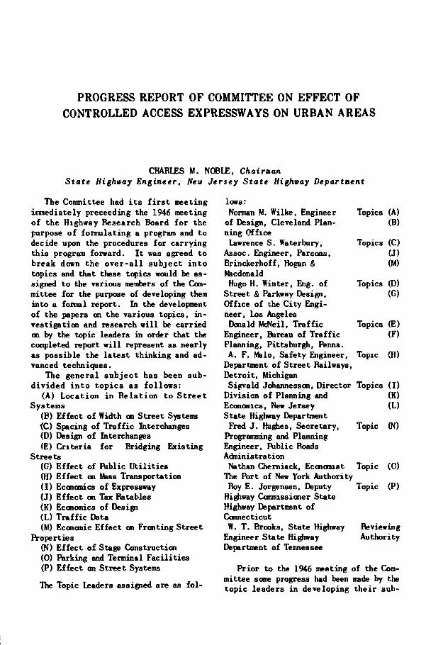
The Committee had i t s f i r s t meeting immediately proceeding the 1946 meeting of the Highway Research Board f o r the purpose of formulating a program and to decide upon the procedures for carrying th is program forward. I t was agreed to break down the o v e r - a l l subject i n t o topics and that these topics would be assigned to the various members of the Committee for the purpose of developing them into a formal report. In the development of the papers an the various topics, i n vestigation and research w i l l be carried on by the topic leaders in order that the completed report w i l l represent as nearly as possible the latest th inking and advanced techniques.
The general subjec t has been subd iv ided i n t o topics as f o l l o w s :
(A) Location i n Re la t ion to S t ree t Systems
(E) Effect of Width on Street Systems <C) Spacing of T r a f f i c Interchanges (D) Design of Interchanges (E) Cr i te r ia fo r Bridging Existing
Streets (G) Effec t of Riblic U t i l i t i e s (H) Effec t on Mass Transportation ( I ) Economics of Expressway (J) Ef fec t on Tax Ratables (K) Economics of Design (L) T r a f f i c Data (M) Economic Ef fec t on Frosting Street
IVoperties (N) Effec t of Stage Construction (0) Parking and Terminal Faci l i t ies (P) Effect on Street Systems
The Topic Leaders assigned are as f o l
lows: Norman M. Wilke, Engineer Topics (A)
of Design, Cleveland Plan- (B) ning Office
Lawrence S. Waterbury, Topics (C) Assoc. Engineer, Parsons, (J) Brinckerhoff, Hogan & (M) Macdonald Hugo H. Winter, Eng. of Topics (D)
Street & Parkway Design, (G) Office of the City Engineer, Los Angeles Donald Md^eil, T r a f f i c Topics (E)
Engineer, Bireau of T r a f f i c (F) Planning, Pittsburgh, Penna. A. F. Malo, Safety Engineer, Topic (H)
Department of Street Railways, Detroit , Michigan Sigvald J(^annessan, Director Topics ( I )
Division of Planning and (K) Eccncniics, New Jersey (L) State Highway Departmeit
Fred J . Hughes, Secretary, Topic (N) Programming and Planning Engineer, Riblic Roads Administration
Nathan Cherniack, Eccnonast Topic (0) The Port of New York Authority
Roy E. Jorgensen, Deputy Topic (P) Highway Connnissioner State Highway Department of Connecticut
W. T. Brooks, State Highway Reviewing Engineer State Highway Authority Department of Tennessee
Prior to the 1946 meeting of the Committee scoie progress had been made by the topic leaders i n developing the i r sub-
TRAFFIC AND OPERATIONS
j ec t s and papers were submitted by Hugo H. Winter, covering the two topics assigned him, namely, (D) Design of Interchanges, and (G) E f f e c t of Public U t i l i t i e s , and by Norman M. W i l k e , on h i s topics (A) Location i n Relation to Street Systems, and (B) E f f e c t o f Width on Street Systems. Papers were also subm i t t e d by S igva ld Johannesson on h i s topics ( I ) Economics of Expressway, (K) Economics of Design, and (L) T r a f f i c Data, and by Lawrence S. Waterbury on his assigned topics of (C) Spacing o f T r a f f i c Interchanges, (J) Ef fec t on Tax Ratables, and (M) Economic E f f e c t on F r o n t i n g S t r e e t P r o p e r t i e s .
These papers were discussed by the Committee in session and suggestions o f fered by the members.
Insofar as the procedures were concerned, i t was decided that during the year topic leaders would submit papers to the Secretary f o r preliminary review by the Chairman and then be circulated among the entire Comnittee membership for comments and suggestions. Such comnents to be sent to the Secretary fo r coordinatioi and transmission to the Reviewing Authori t y .
The Reviewing Author i ty w i l l peruse the or iginal paper together with the comments of Committee members and summarize the various suggestions and recommend revis ions i n the o r i g i n a l manuscript. Iliese recommendations w i l l be transmitted to the Secretary fo r d i s t r ibu t ion to the various authors. The o r i g i n a l author w i l l then revise his manuscript as appears j u s t i f i e d in the l i g h t of the com.-ments of the Committee members and the reconnendation o f the Reviewing Authori t y .
I n t h i s manner i t i s hoped tha t a great deal of ground can be covered in progressing the work of the Committee during the year and that a considerable amount of coordination and threshing out of con t rovers ia l issues may be accomplished, reserving to the Comnittee meetings such issues as can not wel l be resolved by correspondence. I t i s the ultimate aim of the Committee to submit a r epo r t on a l l of the above l i s t e d
topics as a coordinated whole for publ i -caticHi and dissemination to the membership of the Highway Research Board.
I t i s recognized by the Coonittee that many of the topics w i l l necessarily overlap into other Departments and Connittees of the Highway Research Board and i t i s the intention of the Committee to contact appropriate Department and Committee Chainnan where such subjects over-lap in order to avoid o f f e r i n g information in the report which would c o n f l i c t with the findings of other Connittees, and so as to take f u l l advantage of research conducted by such Committees. I t i s earnest ly requested that other Ccmnittees cooperate in t h i s coordinat ion i n order that the entire e f f o r t may merge in with the ac t iv i t i e s of the entire Highway Research Board.
As an a id t o u n i f o r m i t y and understanding the Ccnnittee w i l l use the d e f i n i t ions of highway and t r a f f i c terms a-dopted by the American Associat ion of State Highway O f f i c i a l s , Manual on Uniform T r a f f i c Cont ro l Devices and the Highway Research Board Committee on Highway Capacity.
During the past year the Librarian of the Headquarters S ta f f of the H i g ^ y Research Board has prepared an extensive bibliography covering the various topics being investigated by the Committee and th i s bibliography is appended hereto.
To date papers have been prepared on the fol lowing topics:
(A) Location in Rela- Norman M. Wilke t i cn to Street Systems
(B) Effect of Width on Street Systems
(C) Spacing of T r a f f i c Lawrence S. Interchanges Waterbury
(J) Effec t of Tax Ra tables (M) Economic Effec t on
Fronting Street Properties
(D) Design of Interchanges Hugo H. (G) Effec t of Public Winter
U t i l i t i e s ( I ) Economics of Expressway Sigvald Jo
hannesson (K) Economics of Design
NOBLE - COMMITTEE REPORT
( L ) T r a f f i c Data (N) E f f e c t o f Stage
Cons t ruc t ion (0) Parking and Ter
minal F a c i l i t i e s (P) E f f e c t on S t ree t
Systems
Fred J . Hughes
Nathan Chemi-ack
Boy E. Jorgen-sen
As an ind ica t ion of the progress of
the work of the Committee, two of the above reports are being presented at this meeting, namely, "Parking and Terminal F a c i l i t i e s " by Nathan Qierniack, Econcn-i s t , The Port o f New York A u t h o r i t y (Topic (0)) and "Effect of Stage Construct i o n " (Topic (N))by Fred J . Haghes, Programming and Planning Engineer, I\>blic Roads Adminis trat ion.
P A R K I N G AND T E R M I N A L F A C I L I T I E S
NATHAN CHERNIACK
Economist, The Port of New York Authority
Parking and terminal f a c i l i t i e s i n urban areas inc lude : (a) curb spaces along the e x i s t i n g s t ree t system; (b) o f f street f a c i l i t i e s such as public and pr ivate parking l o t s and garages; (c) parking f a c i l i t i e s w i t h i n commercial buildings for autos and trucks, ranging from recessed s t ree t l eve l truck t a i l board spaces w i t h i n bu i ld ing l i n e s , to large areas below or above street f loors , connected by ramps or elevators; and (d) such specialized terminals as union bus and truck terminals.
Vehicles that now u t i l i z e o f f s t r e e t parking and terminal f a c i l i t i e s a r r ive there f o r the most pa r t v i a e x i s t i n g street systems. Even where urban limited access expressways are avai lable, only portions of vehicles that use o f f s t r e e t parking and terminal f a c i l i t i e s a r r ive via expressways.
As more urban expressways are constructed and areas t r ibutary to expressways expand, increasing proportions of vehicles parking at i nd iv idua l parking and terminal f a c i l i t i e s w i l l a r r ive or depart via expressways. New parking and terminal f a c i l i t i e s w i l l then tend to be located as close to expressways as poss ib le i n order to reduce vehicle t ravel on exist ing street systems to a minimum. This growing intimacy between expressways and large individual parking and terminal f a c i l i t i e s i s bound to create serious t r a f f i c problems, p a r t i c u l a r l y i n the v i c i n i t y of t r a f f i c interchanges. Engineers must consequently provide f l e x ible designs for expressway interchanges that w i l l r e l i e v e i n e v i t a b l e t r a f f i c pressures as they arise, since some types of expansions cannot be connpletely envisaged when the expressways are being planned.
I t i s a commonly accepted fact that a
limited access expressway^lane can handle 3 to 5 times the t r a f f i c of a c i ty street lane. Or, in other words; one expressway lane can del iver enough t r a f f i c to keep 3 t o 5 s t ree t lanes busy absorbing the t r a f f i c , i f the t r a f f i c can be absorbed. (Juery: What happens i f the rate of d i f fusion on the street system in the v i c i n i t y of the expressway i s slowed down by the rate at which cars can be parked at large concentrated of f -s t ree t parking and terminal f a c i l i t i e s ' ' Answer: Chronic t r a f f i c backups on the expressway, when rush hour t r a f f i c i s a r r i v i n g in town.
Conversely several large ind iv idua l o f f s t r e e t parking and terminal f a c i l i t ies located i n a local area in the v ic i n i t y of an expressway entrance ramp may in a peak period deliver to the expressway entrance rastfi a flood of t r a f f i c far i n excess o f i t s a b i l i t y to absorb i t . In this case, too, thereiwould be chronic t r a f f i c congestion on the c i t y s t r ee t system, in peak periods, when t r a f f i c was leaving town.
Approximate locations and spacing of entrance and e x i t rairips are u s u a l l y determined by the vehicular volumes that originate in or are destined f o r one or more interchanges. More precise locations of interchanges can be determined by giving special consideration to i n d i vidual ex i s t ing and potent ia l o f f s t r e e t parking and terminal f a c i l i t i e s tha t would contribute substantial portions of t r a f f i c to speci f ic interchanges. Such o f f s t r e e t parking f a c i l i t i e s would also indicate the design types of entrance and e x i t ramps required. A number of these types are described in Mr. Winter's paper on expressway interchanges. For example, concentrations of parking f a c i l i t i e s in a local area would require that some interchanges be provided with more than merely
TRAFFIC AND OPERATIONS
an a c c e l e r a t i n g or d e c e l e r a t i n g l a n e . Some might requ ire a d j o i n i n g s e r v i c e s t r e e t s that could funct ion as r e s e r v o i r s , l i k e the p l a z a s of v e h i c u l a r bridges and tunne l s . I t must a l s o be borne in mind that while any given in ter change proper may have the capaci ty to d e l i v e r to the expressway a l l the peak period t r a f f i c of the surrounding o f f -street parking f a c i l i t i e s , the expressway i t s e l f at this point would have only the margin of i t s available unabsorbed t r a f -
expressway t r a f f i c delivered by the local interchanges.
In the selection of locations, determination of the number of interchanges, and the provision of extra widths of expressways proper, in given loca l areas, the essent ia l desideratum i s to maintain a proper balance in the capacities of (a) the expressway proper, (b) i t s l o c a l interchanges, (c) the local t r a f f i c l ight controlled street system in the v i c i n i t y of interchanges and (d) the rate of ab - .
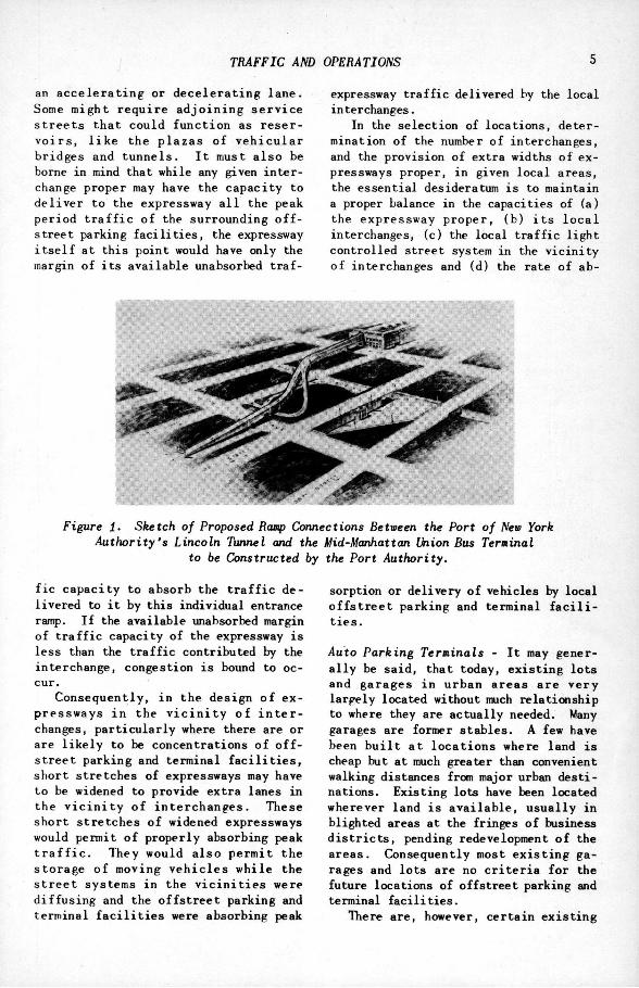
Figure 1. Sketch of Proposed Ramp Connections Between the Port of New York Authority's Lincoln Tunnel and the Mid-Manhattan Union Bus Terminal
to be Constructed by the Port Authority.
f i c capac i ty to absorb the t r a f f i c del ivered to i t by this individual entrance ramp. I f the available unabsorbed margin of t r a f f i c capacity of the expressway i s less than the t r a f f i c contributed by the interchange, congestion i s bound to occur.
Consequently, i n the design of expressways i n the v i c i n i t y of i n t e r changes, par t i cu lar ly where there are or are l i k e l y to be concentrations of o f f -s t ree t parking and terminal f a c i l i t i e s , short stretches of expressways may have to be widened to provide extra lanes in the v i c i n i t y of in t erchanges . These short s t re tches of widened expressways would permit of properly absorbing peak t r a f f i c . They would a l so permit the storage of moving v e h i c l e s whi le the s t r e e t systems in the v i c i n i t i e s were d i f fus ing and the o f f s t r e e t parking and terminal f a c i l i t i e s were absorbing peak
sorption or delivery of vehicles by local o f f s t r e e t parking and terminal f a c i l i t i e s .
Auto Parking Terminals - I t may genera l l y be sa id , that today, ex i s t ing lots and garages i n urban areas are v e r y largely located without much relaticxiship to where they are actual ly needed. Many garages are former s tables . A few have been b u i l t a t l oca t ions where land i s cheap but at much greater than convenient walking distances from major urban des t i nations. Exis t ing lots have been located wherever land i s a v a i l a b l e , u sua l ly in blighted areas at the fringes of business d i s t r i c t s , pending redevelopment of the areas . Consequently most e x i s t i n g garages and lo ts are no c r i t e r i a for the future locations of offstreet parking and terminal f a c i l i t i e s .
There are, however, certain ex i s t ing .
CHERNIACK - EXPRESSWAY TERMINALS
frrrrrnfpgnwmoRiTYBUSTtRMNiiwwrEisiMtBUBTRATO
CIZID
/ z z i r ~ T ] [
L u c
_ _ _ ^ n z i ? C 7 r i i [ U<gM MOTOR BUS ^^I»»1«L^
II • II - | i II •• II W I' 1 .11 1 II II :| ' ,„ L L J II II ZDil \, i. :| l>l i r —I'l
n r
Figure 2
parking f a c i l i t i e s which would require par t icular at tention in connection with the design of proposed urban expressways. They are the concentrations of parking in connection wi th places of public assembly, such as, large ballparks and stadia. Designs of expressway interchanges i n the i r v i c i n i t i e s require special study and treatment, i f chronic t r a f f i c congestion i s to be avoided.
With regard to future o f f s t r ee t parking f a c i l i t i e s , current thinking appears to favor municipally financed lo t s and garages. Where large publ ic parks o f wide boulevards are available, these are being suggested fo r underground municipal parking f a c i l i t i e s . In some c i t i e s l i ke Pi t tsburgh, f o r example, comprehensive plans have been prepared f o r a system of municipal ly financed and operated garages; those near the shopping areas for short time parkers and toward the fringes of the business d i s t r i c t f o r long time parkers. I t i s believed that these plans fo r large municipal parking and tenninal f a c i l i t i e s w i l l eventually materialise, then designs fo r interchanges i n t he i r v i c i n i t i e s should be f l e x i b l e enough to be constructed or enlarged i f and when, t r a f f i c to and from them develops.
I t i s the opinion of the author that, gradually, municipalities w i l l adopt zon
ing ordinances requiring new comnercial buildings to .provide o f f s t r e e t parking and truck berths. Should t h i s be the future trend, o f f s t r e e t parking f a c i l i t ies would once more become less concentrated, more diffused. I h i s gradual d i f fus ion of o f f s t r e e t parking f a c i l i t i e s should improve t r a f f i c conditions around expressway interchanges by spreading peak t r a f f i c loads by the travel time required between nearest and f a r t h e s t parking areas t r ibutary to individual expressway interchanges.
Bus TerninaZs - Interurban and i n t e r c i t y buses usually enter c i t i es from several directions via c i t y streets. Large buses t r a v e l l i n g a long narrow c i t y streets congest these streets out of a l l propor t ion to the number enter ing the c i t y . Where the number of buses are subs tant ia l , municipalities out of se l f protect ion w i l l eventually require them to use a union bus terminal . A union bus terminal would be so located as to be convenient to downtown o f f i ce s , shopping areas, theatres and hotels but also as close to urban expressways as possible so as to u t i l i z e c i t y streets to a minimum. Where munic ipa l i t ies are contemplating requi r ing one or more union bus terminals, expressway interchanges should be
TRAFFIC AND OPERATIONS
mmwL
UNION TOR TRUCK
TERMINAL N0.2 / : " k L I N G T O N
HOBOKEN
KEARNY NCWARK
JERSEY CITY
UNION OTOR TRUCK TERMINAL
Na3
NEWARK New roRK
BAY
MAJOR HIGHWAYS IN THE V I C I N I T Y OF
TWE PORT OF NEW YORK AUTHORITY UNION MOTOR TRUCK T E R M I N A L S
S C A L E I N M I L E S I 2 3 BAYONN
DCmRTUENT OF PORT OEVUOniENT NOVEMBER 24.1947
f igure 2
designed to give easy access to and from such bus terminals.
For example, the Port A u t h o r i t y ' s Union Bus Terminal \n mid-Manhattan w i l l be provided with special ramps ccnnecting the terminal w i th the north and south tubes of the Lincoln Tunnel. These ramps w i l l keep 85% o f the 2,500 d a i l y bus t r ips into the Union Bus Terminal entirel y o f f c i t y s t reets m the v i c i n i t y o f the t e r m i n a l . (A sketch o f the Por t Authority Union Bus Terminal and i t s ramp connections wi th the Lincoln Tunnel i s attached.)
Union Truck Terminals - I n to and out of most c i t i e s long haul, over-the-road t rac to r - t ra i l e r combinations haul f re ight da i l y . Individual operators' truck terminals are usually scattered throughout the c i t y . Many o f these t rucks and t r a i l e r s meander about on the narrow streets of c i t ies picking up and delivering small lo ts of f r e igh t . Whether moving or parking on these narrow streets, these oversized vehicles congest these
narrow streets out of a l l proportion to the numbers o f t r a c t o r - t r a i l e r combinations in relation to other t r a f f i c . Consequently, where t h i s type o f t r ac to r -t r a i l e r t r a f f i c i s growing, municipal i t ies w i l l eventually demand that over-the-road truck op-erators operate out of union truck terminals and that smaller trucks pick up and deliver their f re igh t w i t h i n the c i t i e s . Where union truck terminals are b u i l t , they would be located close to expressways. Lar§e tractor-t r a i l e r combinations would thus ar r ive via expressways and proceed to the Union Truck Terminal using c i t y streets to a minimum.
Where i t i s anticipated that a union truck terminal w i l l be constructed close to an expressway, interchanges i n the v i c i n i t y of the terminal should receive part icular at tention. Expressway in ter changes should be so designed as to be convenient fo r vehicles to enter and depart from the union truck tenninal with a minimum use of c i t y streets. The streets which trucks do use, however, should have
CHERNIACK - EXPRESSWAY TERMINALS
IMt POBT o r NSW YORK AUTHORITVS
UNION TERMINAL FREIGHT STATION N9 2 niHioii MOTon mucH icHynAu
LOCATION-HMttUTTAN H U H HOLLAND TUtMtL SIZE— T i m a H M . smicnmi WTMHOtf mam PLATram oocr
CAPAcmr—
Figure k
the capacity to absorb a l l trucks delivered to them by the expressway in peak [leriods. Interchanges should be designed to pass peak t r a f f i c ; the expressway should be able to absorb a l l trucks delivered thereto by the interchanges. The Port Author i ty i s now constructing two Union Truck Terminals, one in New York C i t y i n lower Manhattan, the other i n Newark, N. J . , and in se lec t ing t he i r locations has recognized these p r i n c i ples.
The truck terminal on Manhattan i s within 1/2 mile of the Holland Tunnel via which vehicu la r crossing most of the over-the-road trucks w i l l arrive at this union terminal. The Manhattan entrance and ex i t of the Holland Tunnel being so convenient to the lower Manhattan Ihion Truck Terminal , t rucks w i l l use c i t y streets to a minimum to reach i t . (See attached sketches which show location of the Port A u t h o r i t y ' s lower Manhattan Union Truck Terminal).
The Newark Terminal i s located close to the exis t ing New Jersey Route 25 and in the v i c i n i t y of proposed Route 100, the major a r t e r i a l routes via which most of the over-the-road trucks w i l l arr ive
at t h i s union t e r m i n a l . The i n t e r changes of the New Jersey routes w i l l be designed to give easy access to the Newark Truck Terminal and consequently there, also, trucks w i l l use the streets m the v i c i n i t y to a minimum. (The i l lus t ra t ions herein show the location of the Port Authori ty 's Newark Truck Termin a l ) .
TRUCK MOVEMENTS TO AND FROM UNION MOTOR TRUCK TERMINAL NO 3
Figure 5
E F F E C T ON C I T Y S T R E E T S OF S T A G E CONSTRUCTION
O F L I M I T E D A C C E S S E X P R E S S W A Y S
FRED J . HUGHES, Programning and Planning Engineer Division One, Public Roads Administration, Albany, New York
SYNOPSIS Stage construction proposals generally stem from a need to stretch available funds
t o secure early r e l i e f . This may be j u s t i f i e d in certain cases but should be accepted only as a last resort a f ter ccnsideration is given to the poss ib i l i t ies of f inding the added amounts (and, probably, sources) of funds so urgently needed to meet and keep pace with our highway requirements.
I f stage construction is necessary, comparisons between the advantages of obtain ing as a f i rs t -s tage operation a f a c i l i t y usable throughout most or a l l of i t s length, as contrasted to the more generally-used method of bui ld ing i t section by section, might be worthwhile. Gett ing work underway over an ent i re project might do much to establish and guarantee the route, avoid rights-of-way delays, encourage and influence re-zoning and other c i t y planning a c t i v i t i e s and resu l t in the e f f i c i e n t and non-c o n f l i c t i n g location of industries, housing and like developments in the urban area.
The primary purpose of urban expressways is , of course, to correct unsatisfactory t r a f f i c conditions an ex i s t ing c i t y s t reets . A good plan for stage construction may produce r e l i e f quickly where needed most and provide a preview of things to come which can help with financing and other problens. Contrariwise, a bad plan could add to the distress on c i t y streets and endanger the entire proposal. Therefore, the ef fects of proposals for stage construction on those streets should carry much weight when the merits of such proposals are evaluated. No set rules fo r determining these e f fec t s can be made because physical, economic and social conditions and t r a f f i c problems d i f f e r in each urban area. However, to assure that a stage construction proposal is sound and workable, a complete analysis of t r a f f i c flows and travel habits seem essent i a l . This analysis should be par t icular ly concerned with the probable e f fec t of the proposal on the loads on exis t ing streets (and intersections) and the potential advantages (or disadvantages) to t r a f f i c which w i l l remain on or be diverted to each street (temporarily or permanently) as wel l as to that accomnodated on the expressway.
For the purposes of this discussion, the term, "stage construction", i s construed as meaning the construction of an expressway to something less than the u l t imate planned improvement but to a stage where the f a c i l i t y or a portion of I t may be opened to and used by t r a f f i c . Our pa r t i cu la r in teres t i n the subject excludes stage construct ion practices such as the acquisition of rights-of-way, grading of the roadbed, or the construction of structures separately from and in advance of paving operations, since these operations do not produce a usable improvement.
Examples of stage construction of i n terest at this time are:
1. Placing a temporary rather than a
permanent pavement. 2. Paving less than the ul t i inate
width of roadway, or one roadway of an ul t imate divided highway.
3. Deferral of construction of grade separations.
4. Deferral of construction of interchanges, or construction of less than the ultimate interchange, for example, building two ramps of a four-ramp plan.
5. Deferral of construction of service roads.
6. Deferral of landscaping, ins ta l lat ion of l i gh t ing and other items not essential to a reasonably safe u t i l i z a t i o n of the improvement.
7. The progressive construction of an expressway by sections or un i t s over a
10 HUGHES - EFFECT ON CITY STREETS
period o f years. In t h i s case a constructed section mig^t be conplete wi th i n i t s l i m i t s but i t would cons t i tu te only one stage o f the construction required to make available the benefits of the ultimate improvement.
Proposals fo r stage construction a l most always stem from a need to stretch currently available funds so that t r a f f i c conditions may be inproved as quickly as possible and pr ior to the time when the entire expressway can be financed. Now, th i s reason f o r construct ing something less than a complete improvement may be a very good one and sometimes the only way to get a p ro jec t s t a r t e d . However, a word of caution seems i n order. Too ready acceptance of the need for improvis ing , by stage construction or otherwise, to overcome an apparent i n a b i l i t y to finance an improvement could well prolong beyond reason the time required to remedy the intolerable t r a f f i c conditions of our urban areas. Without a doubt, i t i s going to be necessary ( in general) to f i n d addit ional amounts (and, probably, new sources) o f funds to meet and keep pace wi th our highway requirements. We should be extremely reluctant to employ stage c o n s t r u c t i o n to s ide-s tep the c r i t i c a l issue of inadequate finances for overwhelming highway needs.
In case immediate construction of a complete improvement i s determined to be impossible, more consideration than i t of ten receives then might wel l be given to the f e a s i b i l i t y of i n i t i a t i n g ac t iv i ty over the en t i r e p r o j e c t as qu ick ly as possible. This might be done by u t i l i z ing one or more of the f i r s t s ix stage construction techniques previously mentioned instead of the more generally-used method of progressive construction of an improvement by sections which are complete in themselves. Getting work underway throu^out the length of the proposed expressway would establish and guarantee the route to be followed by the f a c i l i t y . I t might avoid s e r i o u s delays over rights-of-way. I t also might do much to encourage and influence zoning or re-zoning and other c i t y planning a c t i v i t i e s , and the e f f i c i e n t and n o n - c o n f l i c t i n g location of industries, housing, and l ike developments in the urban area.
A careful study and comparison of the advantages of obtaining as a f i rs t -s tage operation a f a c i l i t y usable throughout most or a l l of i t s length, as contrasted
to building i t section by section, might be highly i l luminat ing and possibly lead to a new concept of the value and f l e x i b i l i t y of stage construction.
However, regardless of a l l other considerations, i t must be kept in mind that the primary purpose of the improvement i s to correct, or at least, relieve unsatisf a c t o r y t r a f f i c c o n d i t i o n s on c i t y streets. Therefore, i t seems obligatory that the effects on those streets should be considered care fu l ly and should carry much w e i ^ t when decisions regarding the nature and extent of stage construction proposals are to be made. A good stage-construction plan might produce r e l i e f quickly where needed most and result i n a substant ia l measure of the desired improvement i n t r a f f i c condit ions being realized and enjoyed several years in advance o f what would otherwise be poss ib le . Also, a good plan f o r stage cons t r u c t i o n could provide a preview of things to come which might help materia l l y w i t h f inancing, r ights-of-way acq u i s i t i o n or other problems. On the other side of the ledger, however, a bad plan could add to the distress on c i t y streets and even endanger the entire proposal by presenting an unfavorable picture of the e f f e c t s of expressway cons t ruc t ion in an urban area.
The e f f e c t on c i t y s treets of stage construction of expressways w i l l depend on the particular physical, economic and soc ia l conditions and t r a f f i c problems exist ing in the urban areas to be entered or traversed as well as on the nature and extent o f each stage construction proposal. For t h i s reason, no set rules f o r evaluating the effects of stage construction can be determined with the idea that they may be applied to a l l proposals which may be advanced. Each case w i l l require intensive study, par t icular ly of the capacities of ex is t ing streets (and the i r intersections), the loads on them, the probable e f f e c t of the proposal on those capacities and loads, and the pot e n t i a l advantages (or disadvantages) i n service to t r a f f i c which w i l l remain on or be d ive r t ed to each s t ree t (tempor a r i l y or permanently) as well as to that accomnodated cn the expressway.
Ohe of the major problems encountered in planning urban expressway construction i s that of providing fo r the co l lec t ion and d i s t r i b u t i o n of t r a f f i c by means of the connecting street network. This pro-
8 TRAFFIC AND OPERATIONS 11
blem may be in tens i f ied when an expressway I S constructed by stages. To assure that a stage construction plan i s both worthwhile and workable, a con^lete analysis of t r a f f i c flows and t rave l habits seems essential. As a minimum, i t is bel i eved that answers to the f o l l o w i n g questions should be determined:
1. Which streets w i l l be benefited by the stage construction proposal and to what ex ten t '
2. Which streets w i l l be required to carry heavier loads than at present and are they capable of doing so?
3. W i l l interchanges to be b u i l t as part of the stage construction plan have adequate capacities?
4. I f I t i s planned to defer grade separations, what w i l l be the e f f e c t on the expressway and c i t y s t r ee t s ' W i l l they function with reasonable e f f ic iency or w i l l ba r r i e r s be created a t heavy cross- t raf f ic streets vdiich might n u l l i f y a l l other advantages?
5. I f a project i s to be constructed by sections, w i l l a par t icu lar section, when completed, be effect ive in providing t r a f f i c r e l i e f i n the area i n which i t i s
b u i l t ' What w i l l be the ( ^ r a t i o n a l behavior at I t s end points and can controls be established which w i l l permit t r a f f i c to traverse the remainder o f the route with reasonable ease u n t i l the entire improvement is completed'
CVice these questions and others suggested by them are answered, i t w i l l be possible to formulate a sound and e f f i cient stage construction plan rather than be compelled to go ahead on a hit-or-miss basis set up mostly with an eye on avai l able funds.
To summarize, i t i s recognized that stage construction may be necessary. I f so, however, the plan t o be fo l lowed should be based on comprehensive and comparative studies which w i l l insure i t is the best that can be devised, that i t w i l l bet ter , not worsen, t r a f f i c conditions, and that no unworkable situations or t r a f f i c bottle-necks w i l l be created by the temporarily curtailed construction program. Also, may I stress again the thought that stage construction should be a last resort rather than the f i r s t " out" when funds are scarce.
12
E X P R E S S W A Y R O U T E S E L E C T I O N AND
V E H I C U L A R U S A G E
R. M. BROWN, i 4 s s i s t o n t E n g i n e e r of Road Design. State Highway Commission of Indiana
SYNOPSIS
From experiences gained ui conducting three cooprehensiTe Origin and Destination Surveys f o r the State Highway Connission of Indiana and the subsequent preparation of T r a f f i c Survey and Highway Plan Reports, this paper presents the development of e f fect ive methods fo r the selection of urban expressway routes and the determination of the i r percent of usage by vehicles.
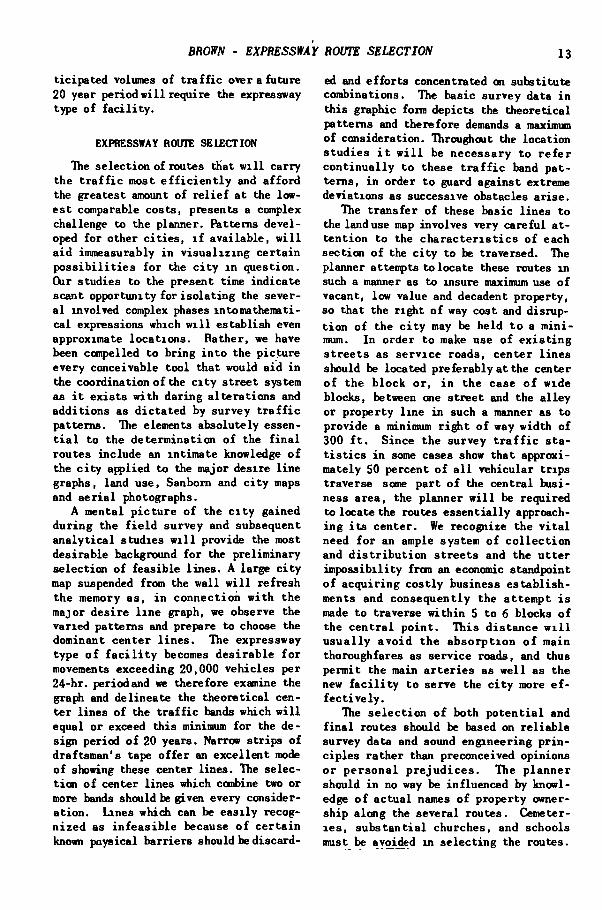
The selection of expressway routes, because of the intr icacies involved, cannot be expressed in mathematical terms, but rather must consider the major desire l ine graphs as the primary basis f o r selection coordinated wi th an intimate knowledge of the c i t y applied to land use, Sanborn and c i t y maps, aer ia l photographs and an intensive f i e l d reconnaisance.
The extent to which vehicles w i l l use the expressway is shown to depend on the "expressway distance" (the length of the expressway portion of the t r i p ) , the "access distance" (the length of c i t y streets used to enter and leave the expressway in connection with a t r i p ) , and the "adverse distance" (the increased distance required fo r the t r i p via the expressway as compared to a more direct route using the c i t y streets) . Speeds oa the expressway were assumed as twice those on c i t y streets. From these conceptions the expression
[ ' l ^ ' 2 ] X '3 P 100 where ' ~ Percent of expressway usage,
f l - Factor based on "expressway d i s t a n c e , " 2 ~ Factor based on "access d i s t ance , " and '3 - Factor based on "adverse distance",
provides a ra t ional method for computing the actual percent usage of expressway. Laborious calculations involved in the application of the formula are eliminated by the use of a graph or mechanical device developed m connection with the study.
The methods reported i n t h i s paper f o l - other engineers engaged i n t h i s f i e l d , low f r o m p e r s o n a l expe r i ence gained m The comple t ion o f the comprehensive conducting three comprehensive o r i g i n and o r i g i n and d e s t i n a t i o n survey and the d e s t i n a t i o n surveys f o r the Sta te Highway T r a f f i c Survey Report con ta in ing a l l the CkHnnission o f Indiana i n c i t i e s w i t h popu- basic data , t a b l e s , d e s i r e l i n e graphs, l a t i o n s between 120,000 and 400,000 and and kindred items brings the planner face the subsequent p r e p a r a t i o n o f a b a s i c to face imnediately w i t h t w o a l l important t r a f f i c Survey Report and a Highway Plan ques t i ons : Where shou ld the routes be Report f o r each c i t y . I n connection w i t h located^ How many vehicles w i l l use them? a l l o f t h i s work, i t has been our p rac t i ce For the purposes o f t h i s d i s c o u r s e , we t o review a l l a v a i l a b l e s i m i l a r r e p o r t s w i l l assume the c i t y i n ques t i on has a f o r o the r c i t i e s and seek the counsel o f popula t ion exceeding 100,000 and the an-
BROWN - EXPRESSWAY ROUTE SELECTION
tici cipated volumes o f t r a f f i c over a f u t u r e 20 year per iod w i l l require the expressway type o f f a c i l i t y .
EXPRESSWAY ROUTE SELECTION
The s e l ec t i on o f routes tKat w i l l ca r ry the t r a f f i c most e f f i c i e n t l y and a f f o r d the greatest amount o f r e l i e f a t the lowe s t comparable costs , presents a complex challenge to the planner. Patterns deve l oped f o r other c i t i e s , i f ava i l ab l e , w i l l a i d immeasurably i n v i s u a l i z i n g c e r t a i n p o s s i b i l i t i e s f o r the c i t y i n ques t i on . Q i r s tudies to the present time i n d i c a t e scant oppor tun i ty f o r i s o l a t i n g the severa l involved complex phases i n to mathematica l expressions which w i l l e s t ab l i sh even approximate l o c a t i o n s . Rather , we have been compelled to b r i n g i n t o the p i c t u r e every conceivable t o o l t ha t would a i d i n the coordinat ion o f the c i t y s t r e e t system as i t e x i s t s w i t h d a r i n g a l t e r a t i o n s and a d d i t i o n s as d i c t a t e d by survey t r a f f i c pa t te rns . The elements absolu te ly essent i a l t o the d e t e r m i n a t i o n o f the f i n a l rou tes inc lude an i n t i m a t e knowledge o f the c i t y appl ied to the major desire l i n e graphs, land use, Sanborn and c i t y maps and a e r i a l photographs.
A mental p i c t u r e o f the c i t y gained d u r i n g the f i e l d survey and subsequent a n a l y t i c a l s tudies w i l l provide the most des i rab le background f o r the p r e l i m i n a r y se lec t ion o f f ea s ib l e l i n e s . A large c i t y map suspended from the w a l l w i l l r e f r e s h the memory as , i n c o n n e c t i o n w i t h the major d e s i r e l i n e graph, we observe the va r ied pat terns and prepare to choose the dominant cen te r l i n e s . The expressway type o f f a c i l i t y becomes d e s i r a b l e f o r movements exceeding 20,000 veh ic les per 24-hr . per iod and we therefore examine the graph and de l inea te the t h e o r e t i c a l cent e r l i n e s o f the t r a f f i c bands which w i l l equal o r exceed t h i s minimum f o r the des ign per iod o f 20 years. Narrow s t r i p s o f d ra f t sman ' s tape o f f e r an e x c e l l e n t mode o f showing these center l i n e s . Tlie select i o n o f center l i n e s ^ i c h codibine two or more bands should be given every considera t i o n . Lines which can be e a s i l y recogn i z e d as i n f e a s i b l e because o f c e r t a i n known pnysical b a r r i e r s should be d i sca rd-
13
ed and e f f o r t s concentrated on subs t i tu t e combinat ions . The basic survey data i n t h i s graphic form depicts the t heo re t i c a l pat terns and the re fo re demands a maximum o f cons idera t ion . Throughout the l oca t ion s t u d i e s i t w i l l be necessary t o r e f e r c o n t i n u a l l y t o these t r a f f i c band p a t t e rns , i n order t o guard against extreme devia t ions as successive obstacles a r i s e .
The t r a n s f e r o f these basic l i n e s t o the land use map involves very c a r e f u l a t t e n t i o n t o the c h a r a c t e r i s t i c s o f each sec t ion o f the c i t y to be t raversed. The planner attempts to locate these routes i n such a manner as to insure maximum use o f vacant, low value and decadent p roper ty , so tha t the r i g ^ t o f way cost and d i s rupt i o n o f the c i t y may be he ld t o a m i n i mum. I n o rder t o make use o f e x i s t i n g s t r e e t s as s e r v i c e roads, cen te r l i n e s should be located p re f e r ab ly a t the center o f the b l o c k o r , i n the case o f wide blocks , between one s t r e e t and the a l l e y or p rope r ty l i n e i n such a manner as to provide a minimum r i g h t o f way w i d t h o f 300 f t . Since the survey t r a f f i c s t a t i s t i c s i n some cases show t h a t approx i mately 50 percent o f a l l veh icu la r t r i p s t raverse some p a r t o f the c e n t r a l bus i ness area , the planner w i l l be r equ i r ed to locate the routes e s s e n t i a l l y approachi n g i t s c e n t e r . We recognize the v i t a l need f o r an ample system o f c o l l e c t i o n and d i s t r i b u t i o n s t r e e t s and the u t t e r i m p o s s i b i l i t y from an economic standpoint o f a c q u i r i n g c o s t l y business e s t a b l i s h ments and consequen t ly the a t t e m p t i s made t o traverse w i t h i n 5 t o 6 blocks o f the c e n t r a l p o i n t . T h i s d i s t a n c e w i l l u s u a l l y a v o i d t he a b s o r p t i o n o f main thoroughfares as se rv ice roads, and thus pe rmi t the main a r t e r i e s as w e l l as the new f a c i l i t y t o serve the c i t y more e f f e c t i v e l y .
The s e l e c t i o n o f both p o t e n t i a l and f i n a l routes should be based on r e l i a b l e survey data and sound eng inee r ing p r i n c i p l e s r a t h e r than preconceived opinions o r p e r s o n a l p r e j u d i c e s . The p l a n n e r should i n no way be i n f l uenced by knowledge o f a c t u a l names o f p rope r ty ownersh ip a long the several rou tes . Cemeteri e s , s u b s t a n t i a l churches, and schools must be avoided i n s e l e c t i n g the routes .
14 TRAFFIC AND OPERATIONS
A v e r i t a b l e l a b y r i n t h o f l i n e s w i l l thus be developed from which the f i n a l system must be evolved.
An i n t e n s i v e e x a m i n a t i o n o f these l i n e s w i l l reveal c e r t a i n pat terns which have p o s s i b i l i t i e s o f d e f i n i t e considerat i o n f o r the u l t i m a t e r o u t e s . For the normal c i t y o f t h i s c l a s s , the system w i l l usua l ly require two major routes app r o x i m a t e l y a t r i g h t angles w i t h each o t h e r and, i n gene ra l , p a r a l l e l i n g the e x i s t i n g s t r e e t s . E n l a r g e d o b l i q u e a e r i a l photographs taken as an e s sen t i a l p a r t o f the survey w i l l prove an i n v a l u able a i d t o the s tudy and s e l e c t i o n o f the most d e s i r a b l e l i n e s . Sanborn maps p r o v i d e d e t a i l e d i n f o r m a t i o n f o r each block i n the c i t y . C i t y p l a t maps supply n e c e s s a r y s t r e e t , a l l e y , and b l o c k w i d t h s . A comprehensive coord ina t ion o f the a e r i a l photographs and maps by the p l a n n e r se rves t o e l i m i n a t e p o s s i b l e l i n e s and es tab l i sh several groups o f pot e n t i a l routes worthy o f exhaust ive examina t i on .
In preparat ion f o r f i e l d i n v e s t i g a t i o n these l i n e s are reproduced on combined sec t ions o f pho tos t a t i c reproductions o f Sanborn maps ( s c a l e 1 i n . ' 100 f t . ) . F i e l d maps prepared i n t h i s way he lp the i n v e s t i g a t o r t o i d e n t i f y an area q u i c k l y and serve as a cons tan t reminder o f the na tu re o f the area. A l t e r a t i o n s i n the l ines as d i c t a t ed by the f i e l d s tudies can l>e shown i n red on these maps f o r f u t u r e use i n the o f f i c e . L i b e r a l time should be a l l o t e d to t h i s reconnaisance i n order tha t the number o f p o t e n t i a l l i n e s can be r e duced t o the absolu te minimum f o r f i n a l c o n s i d e r a t i o n and comparat ive s t u d i e s . By f i e l d observations i n cou iec t ion w i t h our route studies i n South Bend-Mishawake, I n d i a n a w i t h a combined p o p u l a t i o n o f 140,000, we f i n a l l y ru l ed out a l l p a r a l l e l l i n e s w i t h the except ion o f a 2 -mi l e s e c t i o n which i n v o l v e d the a l t e r n a t e o f a c q u i r i n g e i t h e r a r e s t r i c t e d r a i l r o a d r i g h t - o f - w a y w i t h a minimum o f r e s iden t i a l property or adequate r i ^ t - o f - w a y i n a p a r a l l e l l oca t i on w i t h a greater amount o f r e s i d e n t i a l p roper ty . The coitf iarat ive s t u d y r e v e a l e d a s a v i n g i n c o s t o f 3100,000, and a l a r g e r percent o f v e h i c u l a r usage f o r the l a t t e r r o u t e . The
s e l e c t i o n o f the f i n a l routes i n p r e f e r ence t o a l t e rna t e p a r a l l e l l i n e s can, i n many cases, be determined by o f f i c e and f i e l d observa t ions o f the r e l a t i v e p r o per ty values, the advantages o f more adequate access p o i n t s , the a d a p t a b i l i t y o f e x i s t i n g s t r e e t s f o r se rv ice roads, the g r e a t e r p o t e n t i a l v e h i c u l a r usage, and the lesser cons t ruc t ion costs . For cases where uncer ta in ty e x i s t s , exhaustive comp a r a t i v e s tud ie s should be performed i n which the r e l a t i o n o f b e n e f i t s t o cos ts should be g iven f u l l c o n s i d e r a t i o n . I n our s t u d i e s up t o the p resen t t ime we have had no mtgor case i n which an ac tua l b e n e f i t - c o s t r a t i o s tudy was app l i ed t o the p re l iminary s e l ec t i on o f l i n e s . However, f o r the f i n a l routes, we have e v a l uated a n t i c i p a t e d b e n e f i t s i n monetary terms f o r t ime saved and r e d u c t i o n i n a c c i d e n t s .
I n general the d i r e c t representa t ives o f the s e v e r a l a f f e c t e d gove rnmen ta l u n i t s w i l l have co l labora ted i n the f i n a l stages o f the l i n e s e l e c t i o n t o give i n f o r m a l a p p r o v a l t o t h e f i n a l r o u t e s . Formal a p p r o v a l shou ld be ga ined i n a subsequent conference w i t h the respons i ble o f f i c i a l s . I t i s our l a t e s t p rac t i ce to arrange conferences w i t h the e d i t o r s o f the newspapers f o r a preview o f our p r o posed routes so tha t , i f possible , we gain t h e i r t e n t a t i v e approva l . I n a l l these conferences we request tha t plans exhibi-^ ted and discussed be he ld i n s t r i c t c o n f i dence pending approval o f the f i n a l r epor t a t some l a t e r d a t e . The acceptance o f t h i s phase o f the p r o j e c t by responsible o f f i c i a l s paves the way f o r the next v i t a l step i n the eva lua t ion o f the system, tha t o f d e t e r m i n i n g the expec ted v e h i c u l a r usage o f the f a c i l i t y .
VEHICULAR U5ACE OF THE EXPRESSWAY
L i deve lop ing the proper l o c a t i o n o f the expressway to serve the la rges t volume o f veh icu la r t r a f f i c , we are faced w i t h a number o f f ac to r s which in f luence i t s percent o f usage. The c i t y s t ree t s w i l l cont inue t o ca r ry a l l shor t t r i p s and others which c o u l d u t i l i z e the expressway f o r only a short distance ( less than one h a l f m i l e ) as w e l l as those t r i p s f o r which ad-
BROW - EXPRESSWAY ROUTE SELECTION 15
verse distance would be a p r o h i b i t i v e fac t o r . "Die expressway w i l l c a r r y v a r y i n g percentages o f a l l o the r types o f t r i p dependent on t h e i r course w i t h respect to the f a c i l i t y and the s e r v i c e a b i l i t y o f the e x i s t i n g s t r e e t system. O i our i n i t i a l p r o j e c t , t r a f f i c f lows were developed by an experienced recorder choosing a pe rcen t o f usage by persona l judgment . He was guided by an in t imate knowledge o f the c i t y , the assumption o f a 2 :1 speed r a t i o on the expressway as compared w i t h c i t y s t r e e t s and, f rom v i s u a l inspec t ion o f the map, by the r e l a t i v e dis tance v i a the expressway and n o m a l s t r e e t r o u t i n g . Hie recorder in t e rp re t ed the 2 :1 r a t i o t o mean tha t where the time v i a the expressway equa l l ed the time v i a a more d i r e c t rou te , 50 percent o f the t r i p s would use the expressway; and o n l y i n the case where the time v i a the expressway was one h a l f t h a t by any o the r rou te would 100 percent o f the t r i p s be considered to use i t . Between these l i m i t s p ropo r t i ona t e pe rcen tages o f expressway usage were determined dependent on the r e l a t i v e time r a t i o s .
We soon recognized t h a t t h i s method f a i l e d to i nc lude a l l f a c t o r s a f f e c t i n g the movements but ra ther that i t depended almost e n t i r e l y on the good judgment o f the engineer pe r fo rming the t a b u l a t i o n . In the preparat ion o f subsequent repor ts , i t was t h e r e f o r e decided to explore the p o s s i b i l i t i e s o f an e m p i r i c a l f o r m u l a which, regardless o f the recorder, would produce the same r e s u l t s . This research l ed us to the conclusion tha t percent o f usage i s governed by three p r i n c i p a l f a c to rs which we designated as F^, F2 and F3.
f J i n v o l v e s the d i s tance f o r which a g iven t r i p can use the expressway. F2 considers the r e l a t i o n s h i p between t h a t d i s t a n c e and the t o t a l l e n g t h o f t r i p .
i s concerned w i t h the ex t ra or adverse d i s t ance necessary t o reach and use the expressway.
A f t e r considerable d i scus s ion , t r i a l and experiment i t was determined t h a t r a t e d equal i n importance t o the combina t ion o f F j and F2 and, f u r t h e r , tha t F i was more important than Fn by a r a t i o o f 7 :3 . Optimum values o f 70, 30, and 100 respec t ive ly were there f o r t assigned and
the composite f a c t o r , F, f o r the u l t ima te percent o f usage set up as:
(F, + F , ) x F ,
100
The e s s e n t i a l d is tances p e r t i n e n t to p o t e n t i a l expressway t r i p s and necessary to develop formulae f o r the severa l f ac tors were:
a = Expressway distance, the length i n m i l e s o f the expressway p o r t i o n o f the t r i p .
b - Access d i s t a n c e , the l e n g t h i n mi les o f the c i t y s t r e e t p o r t i o n o f the t r i p .
c ' S t r ee t d i s tance , the t o t a l l ength o f t r i p i n mi les by the most advantageous route us ing only c i t y s t ree t s .
From these distances: a + 6 = t o t a l l eng th o f t r i p v i a the
expressway and o + 6 - c = Adverse distance - t; Factor F j r e f l e c t s on ly the i n f l u e n c e
which expressway d is tance exe r t s on the p e r c e n t o f usage. We r ecogn ized t h a t there w i l l be a c e r t a i n amount o f inconvenience i n e n t e r i n g and l e a v i n g an expressway, r e l a t i v e l y important f o r shor t b u t o f minor consequence f o r l o n g expressway d i s tances . D r i v e r s would tend to weight the bene f i t s against the inconveniences invo lved and would, i n va ry ing degrees, choose to use the expressway. I n l i g h t o f t h i s concept ion i t was our consensus tha t percent o f usage would be zero f o r t r i p s w i t h expressway distances o f less than one h a l f mi l e (when a = 5.4) as a s u f f i c i e n t d i s t a n c e by which the saving i n time would be ample to n u l l i f y the i n c o n v e n i e n c e s . For va lues o f F-^ between those p o i n t s , a parabol ic v a r i a t i o n w i t h ve r t ex a t the upper l i m i t (70 a t 5 .4 m i l e s ) was s e l e c t e d because i t provides a sharp r i s e i n values f o r the expressway distances near the lower l i m i t where i t i s apparent the rate o f increase would be grea tes t . Die d e t a i l e d d e r i v a t i o n o f Factor F i based on these assumpt i o n s i s r e c o r d e d i n A p p e n d i x A and d e v e l o p s the f o r m u l a :
F i •• - 2.8a2 + 30.24a - 11.65
16 TRAFFIC AND OPERATIONS
f o r values o f a, expressway dis tance, between 0.4 and 5.4 mi l e s . For lesser and grea ter values o f a, F^ r e t a i n s i t s r e s p e c t i v e minimum ( 0 ) and maximum ( 7 0 ) v a l u e s .
Fac to r sbows the e x t e n t t o which the access distance inf luences expressway usage. I t can best be v i s u a l i z e d by obs e r v i n g the r e l a t i o n o f the access d i s tance to the expressway distance when the o r i g i n and d e s t i n a t i o n o f the t r i p are located on opposite sides o f the expressway route . When these points are imnedia t e l y ad jacent to the expressway, i t i s the obvious and poss ib ly (mly d i r e c t route f o r the t r i p . As o r i g i n , d e s t i n a t i o n or both move away f rom the expressway, an i n c r e a s i n g number o f p a r a l l e l s t r e e t s w i l l p r e s e n t t o t he d r i v e r n u m e r o u s a l t e r n a t e ways t o n e g o t i a t e the t r i p w i t h o u t r e s o r t to the expressway. The greater the access dis tance becomes, the greater the p r o b a b i l i t y w i l l be tha t some o f these s t r e e t s , because o f t h e i r d i s tance from the expressway, w i l l be r e l a t i v e l y f r e e f r o m c o n g e s t i o n and w i l l t he re fo re minimize the expressway advantages. A r e l a t i o n was t h e r e f o r e e v a l u a t ed on the bas i s o f the r a t i o o f the expressway d i s t a n c e t o the t o t a l t r i p l e n g t h v i a the expressway. When t h i s r a t i o i s 1 : 1 , t h a t i s when the access d i s t ance (6) i s zero . Fac tor F2 has i t s optimum value ( 3 0 ) . Zero usage was assumed when t h i s r a t i o reached 1:10 on Uie premise t h a t pe rcen t o f usage would be n e g l i g i b l e when the t o t a l l ength o f t r i p was ten t imes the l e n g t h o f expressway w h i c h c o u l d be used. T h i s zero p o i n t could l o g i c a l l y have been taken where the r a t i o was zero (one to i n f i n i t y ) w i thou t m a t e r i a l l y a f f e c t i n g the net r e s u l t but we p re fe r r ed to r e s t r i c t our ca lcu la t ions to a f i n i t e l i m i t .
For values o f F^ between the s t a t e d l i m i t s a s t r a i g h t l i n e v a r i a t i o n was used on the premise t h a t usage w i l l vary a l most d i r e c t l y w i t h t h i s r a t i o . The det a i l e d d e r i v a t i o n o f Factor based on these assumptions i s shown i n Appendix B and develops the formula:
Factor F3 r e f l e c t s the e f f e c t o f adverse distance on the percent o f expressway usage. Adverse d i s t a n c e v i a t h e a d d i t i o n a l d i s t ance o f t r a v e l r e q u i r e d v ia the expressway as compared to tha t by the e x i s t i n g s t r e e t s . The speed on the expressway i s , i n every case, assumed to be tw ice t h a t on the e x i s t i n g s t r e e t s . I t i s our o p i n i o n t h a t the v a r i a b l e speeds d u r i n g the day r e s u l t i n g f r o m t r a f f i c volume changes w i l l a u t o m a t i c a l l y maintain t h i s average r a t i o o f 2 : 1 . For example we know t h a t increased v o l umes on the expressway imply the same on the c i t y s t r e e t w i t h a corresponding r e d u c t i o n o f speeds on both f a c i l i t i e s and under l i g h t t r a f f i c , speeds increase but l o g i c a l l y i n a p p r o x i m a t e l y the same r a t i o .
Oi the basis o f the 2 : 1 speed r a t i o , then, from a t heo re t i ca l s tandpoint , when the r a t i o o f the adverse distance to expressway distance ( v : a ) i s 1:2 ( 0 . 5 ) , the time r e q u i r e d v i a e i t h e r route would be the same, s ince , by d e f i n i t i o n :
(1) V = a + b - c
(via express- o . 6 _ . . _ c way route) M « 2 ~ 7 (via city
^ ^ >• street
when I,- 5 + b
route) (2)
F2 = 33.3 0 + 6
3.3
by substituting in equation (1) the value of c from equation (2)
v = a + b - - - b or 2
C o n d i t i o n s r e s u l t i n g i n e q u a l i t y o f time requirement f o r the two routes would seem to j u s t i f y an assumption o f 50 percent but from a p r a c t i c a l s t andpoin t we considered the expressway route somewhat less favorab le because o f more i n v o l v e d t u r n i n g movements and t h e r e f o r e a r b i t r a r i l y s e t the usage a t 40 percent f o r t h i s c o n d i t i o n . Oj)timum usage i s a t t a i n ed when the adverse d i s t a n c e i s z e ro , i . e . when the length o f t r i p i s the same v i a e i t h e r route . Hie parabol ic f u n c t i o n was selected to express the f u l l range o f F^ values w i t h i t s ve r t ex a t a value o f
100 when § = 0 and w i t h a v a l u e o f 40
BROWN - EXPRESSWAY ROUTE SELECTION 17
when ^ = 0 .5 . T l i i s choice fo l l owed from the c o n v i c t i o n t h a t the r a t e o f change should be a t a maximum below the c o n t r o l l i n g va lue o f 40 and s h o u l d decrease g r a d u a l l y as F3 approached i t s optimum v a l u e . Mathemat ica l p r o j e c t i o n gave a
zero value f o r F3 when ^ •» .645. The det a i l e d d e r i v a t i o n o f Factor F3 based on these assumpticns i s recorded i n Appendix C and develops the equation:
F3 = 100 - 240
Hie a p p l i c a t i o n o f the method to the Determination o f expressway usage by veh i c l e s IS very s imple and, f o r any des i r e d movement, requires the measurement o f the pr imary distances invo lved i n the fo rmula as p r e v i o u s l y d e f i n e d : ( 1 ) expressway dis tance a, (2) access dis tance 6; and (3) s t r e e t dis tance c. For each p o t e n t i a l expressway movement the recorde r , by means o f a f l e x i b l e tape, scales the b and c distances on a c i t y map upon which has been d e p i c t e d the expressway system i n c l u d i n g a l l s e r v i c e roads, entrances and e x i t ramps. Impor tan t c i t y thoroughfa res were g iven a d i s t i n c t i v e c o l o r t o a i d the r eco rde r i n s e l e c t i n g the most f avorab le rou tes . Distances a between a l l access po in ts o f the expressway were measured prev ious ly and shown i n a t a b l e t o e l i m i n a t e repeated measurements.
For example: Between two s p e c i f i c t r a c t s we have a movement o f 130 t r i p s w h i c h , by o b s e r v a t i o n , w o u l d i n v o l v e p o t e n t i a l expressway usage. S e l e c t i n g the access p o i n t s , c o n s u l t i n g the t a b l e f o r a and measuring 6 and c, we f i n d :
a = 6.0 b = 3.0 c » 8.0 v = a + 6 - c = 6 + 3 - 8 = 1.0 A p p l i c a t i o n i n the basic formula p r o
duces: [70 (o exceeds 5.4)+33.3 - 3 3]
100
[100 - 240 (^) ^ ]
C70 + 19] X 94 100
= 84
T r i p s on the expressway t h e r e f o r e would be 84 percent o f 130 <> 109 t r i p s they would app ly between the s e l e c t e d access p o i n t s . The remain ing 21 t r i p s would use the a v a i l a b l e c i t y s t r e e t s .
These f i n a l f o r m u l a e were r i g i d l y tes ted by a p p l y i n g them to a comprehens ive s e l e c t i o n o f a c tua l t r i p movements f rom the South Bend p r o j e c t . The per centages o f expressway use thus computed were observed i n each case to be so comp l e t e l y s a t i s f a c t o r y , tha t we have adopted t h i s method f o r a l l p r o j e c t s . I t has f a c i l i t a t e d g r ea t l y the mechanics o f t h i s phase o f the work and assured us o f cons i s t e n t accurate r e s u l t s .
Hie cumbersome work e n t a i l e d i n applyi n g these formulae to the c a l c u l a t i o n o f these fac tors was e l iminated by preparing a graphic ca l cu l a to r from which the three f a c t o r s cou ld be s e l e c t e d by u s i n g the p e r t i n e n t d i s t a n c e s i n v o l v e d i n the fonmi l ae . Figures 1 and 2 show the use o f t h i s device m . the de t e rmina t ion r e s p e c t i v e l y o f F a c t o r s Fj^, F2 and^F3. (Note: Figures 1, 2 and 3 are i n the back o f t h i s book.) Factor F j i s read d i r e c t l y as a stub item on the l e f t side o f the c h a r t . For value o = 6, F j = 70 ( F j = 70 f o r a l l values o f a above 5 . 4 ) .
For F2 , the v a l u e o f a + 6 on the p ivoted arm scale ( F i g . 4) i s brought to an i n t e r s e c t i o n w i t h the v e r t i c a l l i n e th rough the a v a l u e on the top s c a l e . The reading where the arm i n t e r s e c t s the upper arc i s the value f o r F2. For our example 0 + 6 = 9 i n t e r s e c t s 0 = 6 showing a value m the upper arc f o r F2 = 19. For F3, the value a on the p i v o t e d arm scale ( F i g . 5) i s brought t o an i n t e r s e c t i o n w i t h the v e r t i c a l l i n e through the V value on the top scale . The readi n g where the arm i n t e r s e c t s the lower arc i s the value f o r F3. For our examp l e , a = 6 i n t e r s e c t s v = 1 to produce F3 - 94. The r e c o r d e r c o m p l e t e s t h e c o m b i n a t i o n o f t h e f a c t o r s on a c a l c u l a t i n g m a c h i n e .
Since the development o f the described t o o l f o r d e t e r m i n a t i o n o f f a c t o r s , Mr. P. M. Cass idy o f the I n d i a n a D i s t r i c t O f f i c e o f the P u b l i c Boads A d m i n i s t r a t i o n , who had consul ted w i t h us on t h i s
18 TRAFFIC AND OPERATIONS
study, f u r t h e r i n t e r e s t e d h imse l f i n the p r o j e c t by developing a mechanical device from a se r ies o f nomographs designed and arranged to perform coo^ le t e ly the s o l u t i o n o f a l l equations i n c l u d i n g the addi t i o n s , s u b t r a c t i o n s and m u l t i p l i c a t i o n s i n v o l v e d . F i g u r e 3 i s a photograph o f the device depic ted to show how i t would solve the s ta ted example.
The operat ion o f the device i s as f o l lows: The l e f t s l i d i n g p o i n t e r i s moved to a equal 6.0, the r i g h t s l i d i n g poin ter IS moved to b equal 3 .0 , the s l i d e r on the tape near the center i s moved so t h a t c p o i n t s to 8.0 on the c s ca l e . S t r i n g 1 ( r evo lv ing about the l e f t p o i n t e r ) i s moved around to p o s i t i o n 1 so as t o touch the r i g h t po in te r i n which p o s i t i o n F2 i s determined (19) from where the s t r i n g crosses the d i a g o n a l F2 s c a l e . Nine teen i s then added mental ly to the value o f F i ( 7 0 ) wh ich i s g i v e n o p p o s i t e the a r e a d i n g (th\s a d d i t i o n which i s always very simple i s the only mental c a l c u l a t i o n required i n t h i s method) and t h i s sum (89) i s se t on the extreme l e f t hand sca le o f + F2 sca le . S t r i n g 1 i s then moved around t o p o s i t i o n 2 so t h a t i t passes through the va lue o f 1.0 on the v s c a l e ( 4 t h f r o m l e f t ) and the e x t e n s i o n o f t h i s l i n e through the i n t e r s e c t i o n w i t h the diagonal F3 scale gives the value o f F3 equal t o 94. I t w i l l be noted t h a t v was obtained d i r e c t l y by reading i n the l i t t l e , opening o f the s l i d e r on the tape. ( I t i s j u s t c o i n c i d e n c e t h a t s t r i n g 1 c rossed the va lue o f V equa l 1,0 a t t h i s p o i n t . ) . S t r i n g 2 i s then revolved ( t o p o s i t i o n 1) so t h a t i t i n t e r s e c t s the v e r t i c a l F3
scale , a t the r i g h t , a t reading o f 94 and the percent usage (84) i s read «*ere t h i s s t r i n g i n t e r s e c t s the " p e r c e n t u sage" scale near the center; then p l ac ing one's thumb on the s t r i n g a t the "percent usage" reading and r e v o l v i n g s t r i n g 2 around t o p o s i t i o n 2 so tha t i t in te r sec t s the'num-ber o f vehic les i n v o l v e d " sca le , f o r the given value o f 130 and which had been set t o s t a r t w i t h , the veh ic le usage i s then determined from the " vehicle usage" scale which reads 109 vehic les .
A ser ies o f examples run by the use o f graph and by the mechanical device revea l ed a sav ing o f approximate ly 20 seconds f o r each opera t ion by the l a t t e r method. The recorded time by the graph as 1 min . 20 sec. , by the mechanical device 1 min . A f t e r a per iod o f ac tual use o f the mechan ica l device, we a n t i c i p a t e the time per ope ra t i on can be reduced even below the 1 minute f i g u r e . The advantages i n add i t i o n to saving i n time inc lude a grea ter accuracy and e l i m i n a t i o n o f a c e r t a i n amount o f drudgery connected w i t h the f o r mer method. The device requires on ly one operator to determine and record the f lows i n l i e u o f two f o r the o ther method.
The se lec t ion o f expressway routes and the determinat ion o f t r a f f i c f lows thereon c o n s t i t u t e a most impor t an t p a r t o f the development o f a highway p l a n f o r the c i t y . The methods we have described are presen ted f o r the c o n s t r u c t i v e use and c r i t i c i s m o f a l l in te res ted engineers engaged i n t h i s f i e l d to the end tha t through the mutual ly shar ing o f accomplishments, the greates t progress w i l l f o l l o w .
19
APPENDIX A
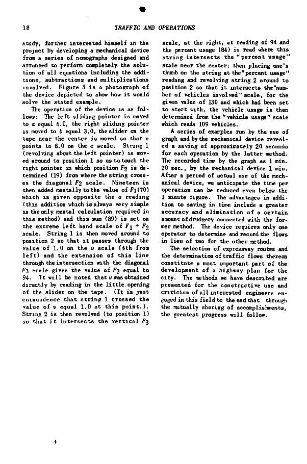
DERIVATION OF FORMULA FOR FACTOR f 1
1 1 was the general consensus o f those a s s o c i a t e d w i t h expressway " u s e " det e r m i n a t i o n s t h a t a f a c t o r t h a t would r e f l e c t on ly the expressway t r i p l e n g t h should have a value o f 0 when the l eng th was 0.4 m i l e and a value o f 100 when the l eng th was 5.4 m i l e s , and f o r lengths i n between the v a r i a t i o n shou ld be para b o l i c .
X • e.f.freiSiM'f Itn^th gf trip (m oi'il.t)
The curve i n d i c a t e d i n the diagram i s t he d e s i r e d curve based on the above c o n d i t i o n s , and the e q u a t i o n o f t h i s curve r e l a t ed to the X and Y axes i s the equation desi red. The basic mathematical expression f o r t h i s p a r t i c u l a r parabola r e f e r r e d t o the X' and Y' axes i s
y ' - k W )2
s o l v i n g t h i s e q u a t i o n f o r k when y' = -100 and x' • -S gives a value f o r ife " -4
there fore y' = -4 ( * ' )2
to change t h i s equation so as to refer to the and K axes instead o f the X' and Y' axes s u b s t i t u t e y - 100 f o r y ' , and x -5.4 f o r x ' , and the equa t ion becomes
y = -4*2 + 4 3 . 2 * - 1 6 . 6 4
This i s the basic equation which expresses i n percent the "use" o f die expressway inso fa r as the length a l o i e i s concerned.
As ind ica ted elsewhere the length f a c t o r c a r r i e s a weight o f on ly 70 i n r e l a t i o n to a w e i ^ t o f 30 f o r Factor i n the f i n a l d e t e r m i n a t i o n o f expressway usage, t h e r e f o r e v a l u e s i n the above equa t ion a re m u l t i p l i e d by 0.7 t o g i v e the p rope r v a l u e s t o F a c t o r F l . The e q u a t i o n then becomes
Fl - -2.8*2 + 30.24* - 11.65
or s ince d e s i g n a t i o n "a" i n s t ead o f ' X " i s used t o i n d i c a t e the l e n g t h o f expressway the e q u a t i o n becomes
f 1 '-i.Sc? + 30.24O - 11.65
Where a i s the expressway l e n g t h o f t r i p i n m i l e s .
20
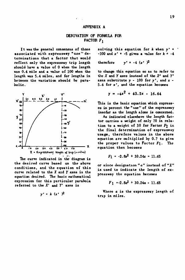
APPENDIX B
DERIVATICN OF FORMULA FOR FACTOR F2
I t was the general consensus o f those associated w i t h expressway " u s e " determi n a t i o n s , t h a t .a f a c t o r t h a t would r e f l e c t the e f f e c t o f t he d i s t a n c e the o r i g i n o r d e s t i n a t i o n was f rom the expressway could be expressed by the r a t i o t h a t the expressway d i s t a n c e was t o the t o t a l l e n g t h o f the t r i p and t h a t the v a l u e s c o r r e s p o n d i n g t o v a r i o u s r a t i o s s h o u l d be as f o l l o w s : 100% when the r a t i o was one, zero % when the r a t i o was 0 .1 and i n between values t o vary as a s t r a i g h t l i n e . The l i n e i n d i c a t e d i n the diagram a t the r i g h t i s the des i red l i n e , based on the above c o n d i t i o n s .
The g e n e r a l e q u a t i o n la y ' mx + d where n i s the s lope o f the l i n e and d the Y a x i s i n t e r c e p t
b u t « = l ^ a n d d = - ( . l ) 1 0 f i = - J | = l l 2 Q .9 .9 .9 9
s u b s t i t u t i n g , the equation becomes
y = (lOQx) _ (100) ( .9 ) ( 9 )
^ 4 ' ' H s Jb ^^ •» -1 u
X % ratio of etfrcsiw*^ teo lb of tr\p ^o total Icnath of trip.
As i n d i c a t e d elsewhere the F2 f a c t o r i n the f i n a l usage percentage determinat i o n should ca r ry a weight o f on ly 30 i n r e l a t i o n t o a w e i g h t o f 70 f o r the f a c t o r , t h e r e f o r e the above e q u a t i o n should be m u l t i p l i e d by 0.3 t o g ive the proper values t o f a c t o r F2 .
the equation f o r f a c t o r F2 then i s
f u r t h e r s u b s t i t u t i o n o f the value o f
tt
a + b - *
the equation becomes
v = 100 L a J -100 ' .9 (a+6) 9
or
F 2 = 3 2 LSLl (of 6)
20 9
F2 = 33.3
where a i s t h e expressway l e n g t h o f t r i p i n m i l e s and 6 i s the access d i s tance i n m i l e s .
21
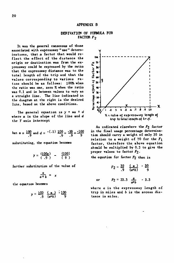
APPENDIX C
I t was the general consensus o f those associated w i t h expressway " u s e " de t e r mina t ions t h a t a f a c t o r t h a t would r e f l e c t usage r e l a t i n g the time v i a the expressway t o the time v i a the more d i r e c t rou te c o u l d be expressed by the r a t i o t h a t ob ta ined between the adverse d i s tance, and the length o f t r i p a c t u a l l y on the expressway, and t h a t the values t h a t these r a t i o s should i n d i c a t e would be as f o l l o w s : 100% when the r a t i o was 0, 40% when the r a t i o was and 0% when the r a t i o was . 6 4 5 .
ITie curve i n d i c a t e d i n the diagram i s the desired curve based on the above cond i t i o n s , and the equation f o r t h i s curve r e l a t e d t o the X and Y axes i s the des i r e d e q u a t i o n .
The basic mathematical expression f o r t h i s parabola which has i t s ver tex a t the i n t e r s ec t i on o f the X' and Y' axes i s
y' = ife(x')2
when y ' = -60 , x' = .5 and s u b s t i t u t i n g and s o l v i n g f o r k, k - -240 and the equat i o n becomes
y' = -240 (* ' )2
To change t h i s equation so as to r e f e r to the and y axes s u b s t i t u t e Y - 100 f o r
DERIVATION OF FORMULA FOR FACTOR f J
% 0
. .-10 • --ID > ^ •
• •40 ..M . . . .
X*
• -10 \ I \
. j \ . . 1 1 A—r->
y comes
X : ratio of adverse distance to dwlaticc of trip on e«pres9wa>f
and X f o r x ' , and the equat ion be-
y = 100 - 240x2
F u r t h e r s u b s t i t u t i o n o f the value o f -a
f o r * and the equat ion becomes t h a t f o r Factor f j which i s
f j = 100 240 ( V ) '
where a i s the expressway length o f t r i p i n miles and v i s the adverse distance i n mi les .
HIGHWAY RESEARCH BOARD
BULLETINS
Papers and progress reports on highway research o f i imedia te i n t e r e s t . I l l u s t r a t e d , paper b ind ing .
No. 1 S i l i c a t e o f Soda as a S o i l S t a b i l i z i n g Agent, by W. Derby leans and J . B. Page (1946) 21 pp 10.]
No. 2 R An Analysis o f General State Enabling L e g i s l a t i o n Dealing w i t h Automobile Parking F a c i l i t i e s , by David R. Levin (1947) 104 pp. ( t emporar i ly o u t - o f - p r i n t ) (
No. 3 Report o f Cionniittee on Highway Organizat ion and Admin i s t ra t ion i n c l u d i n g Aims and A c t i v i t i e s and Special Papers (1947) 23 pp :
No. 4 Report o f Committee on Land A c q u i s i t i o n and Control o f Highway Access and Adjacent Areas and Special Papers (1947) 42 pp 4
No. 5 Report o f Connittee on Conpaction o f Subgrades and Einbankments (1947) 23 pp ;
No. 6 Report o f (Committee on Uses o f Highway Planning Survey Data i n c l u d i n g Special Papers (1947) 40 pp 4
No. 7 An Analys is o f State & i a b l i n g L e g i s l a t i o n o f Special and Local Character Deal ing w i t h Automobile Parking F a c i l i t i e s , by David R, Levin (1947) 30 pp 2
No. 8 Design o f F l e x i b l e Pavements Using the T r i a x i a l Compression Test -
Kansas Method (1947) 63 pp 1
No. 9 Salary and Wage Pract ices o f State Highway Departments (1947 ) 51 pp (
No. 10 Report o f Comnittee on Land A c q u i s i t i o n and Control o f Highway
Access and Adjacent Areas and Special Papers (1948) 46 pp i
No. 11 The Polar ized H e a d l i ^ t System (1948) 40 pp e
No. 12 H i ^ a y Finance (1948) 69 pp 1
No. 13 The Appraisal o f Te r r a in Conditions f o r Highway Engineering
Purposes (1948 ) 99 pp M 1.5
No.14 S o i l Comnittee Reports and Special Papers (1948) t
No.15 Parking, Comnittee Report and Three P&pers (1948) 31 pp f
No. 16 Expressways, Comnittee Report and Three Papers (1948) 21 pp. 4
N A T I O N A L R E S E A R C H C O U N C I L
The National Research Council is a cooperative organization of the scientific men
of America. Its members include, however, not only scientific and technical men but
also business men interested in engineering and industry. It was established in 1916 by
, the National Academy of Sciences.
The Charter of the National Academy of Sciences, under a special act of the
Congress approved by President Lincoln in 1863, provides that "the Academy shall,
whenever called upon by any Department of the Government, investigate, examine,
experiment, and report upon any subject of science or art."
D I V I S I O N O F E N G I N E E R I N G A N D I N D U S T R I A L R E S E A R C H
O F F I C E R S A N D E X E C U T I V E C O M M I T T E E
Chairman F R E D F R I C K M . F E I K E R
Vice-Chairman H A R O L D K . W O R K
Executive Secretary Louis J O R D A N
L Y M A N J . BRIGGS, W I L L I A M B . K O U W E N H O V E N , T H O M A S H . M A C D O N A L D
H I G H W A Y R E S E A R C H BOARD
The Highway Research Board is organized under the auspices of the Division of
Engineering and Industrial Research of the National Research Council. Its purpose
is to provide a national clearing house for highway research activities and information.
The membership consists of 36 technical, educational, industrial, and governmental
organizations of national scope. Associates of the Board are firms, corporations, and
individuals who are interested in highway research and who desire to further its work.
The Board provides a forum for the discussion and publication of the results obtained
by individual research workers; organizes committees of experts to plan and suggest
research work and to study and correlate the results; publishes and otherwise disseminates
information; provides a research information service; and carries on fact finding
investigations. With the cooperation of the highway departments of the states and
Territories and the Public Roads Administration, the Highway Research Board conducts
a Highway Research Correlation Service, to aid the many highway research agencies to
correlate their work through personal visits, conferences, committee work, and dissemi
nation of pertinent information.
HIGHWAY
RESEARCH
BOARD
BULLETIN
11-20
NATIONAL RESEARCH COUNCIL