Embed Size (px)
Citation preview

1 | P a g e
15th September 2017
HIGHLIGHTS
• Further fieldwork at Anchor’s Walsh River/Aspiring project in Far North Queensland has discovered additional gold-silver epithermal veins in the Fluorspar epithermal camp. Follow up work is planned.
• Additional rock chip sampling at Doolan has demonstrated gold-bearing polymetallic quartz veins have potential to extend over a strike length of greater than 1 km.
• Native Title has been extinguished over a portion of the Gemini project (EL 6388) tenement and, subject to land access arrangements and regulatory approvals, the planned geophysical survey will be carried out later this year.
EXPLORATION UPDATE
Anchor Resources Limited ABN: 49 122 751 419 ASX Code: AHR Website: www.anchorresources.com.au

2 | P a g e
Figure 1: Location of Anchor projects in eastern Australia
Aspiring Project, EPM 19447 and Walsh River Project, EPM 25958 (Anchor 100%) Queensland – gold, silver, copper, lead & zinc The Aspiring and adjacent Walsh River tenements are located in the Chillagoe mining district, which forms part of the larger Hodgkinson Province in Far North Queensland. In late 2016 low sulphidation epithermal gold-silver mineralisation was discovered by Anchor at the Fluorspar Group of workings, and granite-related gold-silver-copper-lead mineralisation was verified in a greisen-sulphide alteration zone and a peripheral polymetallic vein at Doolan (see Anchor ASX Quarterly Activity Report dated 21 April 2017). The Fluorspar Group workings and Doolan greisen-sulphide alteration zone are within EPM 25958 (Walsh River) and located 33 km apart. Part of the Doolan mineral system is interpreted to extend into the adjoining EPM 19447 (Aspiring) tenement. The prospects

3 | P a g e
are genetically and geochemically different. The location of the Fluorspar and Doolan prospects is shown on Figure 2.
Figure 2: Location of Fluorspar and Doolan prospects Fluorspar Area Geological reconnaissance and rock chip sampling continued around the Fluorspar and Doolan prospect areas within EPM 25958 (Walsh River) during the current Quarter with a program of field work completed in July-August 2017. At Fluorspar, assay results from composite rock chip samples confirmed the discovery of a third quartz vein having epithermal textures and containing anomalous gold values, named Magnificent (after a historic mineral occurrence in the area). The vein system can be traced sporadically over a strike length of 1,100 metres with anomalous gold values >0.1g/t extending over a length of approximately 970 metres (Figure 3). The epithermal textured quartz vein is interpreted to have been emplaced along a structure informally named the Magnificent Fault. The Magnificent Fault strikes 340°N and has a probable sub-vertical dip. The exact width of the fault and epithermal quartz vein at surface cannot be determined with any confidence because of poor outcrop exposure. Rock chip samples collected from sporadic discontinuous sub-crop along the 1,100 metre long zone yielded numerous gold values ranging from to 0.21g/t Au to 0.87g/t Au (average 0.38g/t Au from a total of 14 samples). Silver values range from 0.14g/t Ag to 15.55g/t Ag (average 3.7g/t). Arsenic values are anomalous and range from 18ppm As to 1,920ppm As (average 254ppm As), with a number of samples >100ppm As. Lithium values are anomalous and range from 258ppm Li to 317ppm Li (average 292ppm Li). Base metal values (copper, lead and zinc) are not anomalous.

4 | P a g e
Figure 3: Magnificent epithermal quartz vein rock chip gold geochemistry
Textures in quartz are typical of formation in an epithermal environment and include lattice-bladed (pseudomorphic replacement of coarse carbonate), quartz vuggs lined with euhedral quartz crystals, encrustation, quartz replacing chalcedony, and growth zoning in coarser quartz grains and crystals. Porcelaneous quartz is also present. These textures are interpreted as indicative of the chalcedonic, vapour phase zone at, or near, the top of an epithermal vein system. Conceptually the combination of lattice-bladed and other epithermal quartz textures, anomalous gold, silver and arsenic geochemistry, very low copper, lead and zinc geochemical values, and strongly anomalous lithium values suggest higher grade gold and silver mineralisation could exist at depth where boiling has occurred in the hydrothermal system. Breccia textures with clay filled voids are evident in some epithermal quartz samples.

5 | P a g e
The epithermal quartz textures and geochemistry along the Magnificent epithermal quartz zone are similar to the Perseverance and Hiker gold anomalous epithermal quartz zones. The Magnificent Fault is sub-parallel to the Hiker Fault located 3.5 km to the east, and both these interpreted north-northwest trending structures are orthogonal to the main northeast trending regional Perseverance Fault (Figure 4).
Figure: 4 Fluorspar historic workings rock chip gold geochemistry and major structures
including the Perseverance, Hiker and Magnificent Faults Rock chip samples of vein quartz, invariably displaying a lattice-bladed texture, along the Perseverance Fault yielded low levels of gold (Figure 5) consistently assaying 0.1 Au to 1.0g/t Au, and up to 6.0g/t Au, (average 0.33g/t Au in 65 samples) over a strike length of >2 km. The Perseverance Fault is a northeast trending sub-vertical regional structure reported to be up to 2 metres wide in the old workings. Silver values range from 0.1g/t Ag to 62g/t Ag with numerous values assaying >5g/t Ag (average 5.9g/t Ag in 65 rock chip samples). The quartz is often associated with fluorite in the main epithermal vein and sometimes stibnite in other secondary epithermal veins emplaced along subsidiary sub-parallel structures to the main vein. The Perseverance Fault is interpreted to continue to the northeast and southwest beyond the extent of the current sampling program and is likely to be at least 3 km long.

6 | P a g e
Figure 5: Perseverance epithermal quartz vein rock chip gold geochemistry In June 2017 follow up reconnaissance work along the possible southwest extension to the Perseverance Lode discovered two, closely spaced, sub-parallel epithermal-style quartz veins 1.5 km southwest of the Perseverance Lode (Figure 6). This vein system, reported as the Hiker Reef, is orthogonal to the regional Perseverance Fault. Sampling of these veins yielded weakly anomalous gold and silver values up to 0.07g/t Au and 3.58g/t Ag from dump material adjacent to a shallow prospecting pit and 0.09g/t Au and 1.01g/t Ag from epithermal textured quartz 1 km to the north-northwest of the prospecting pit. A rock chip sample from the shorter, sub-parallel epithermal quartz vein assayed 0.05g/t Au and 0.86g/t Ag. Although gold values are low, the discovery of epithermal style quartz veins in the broader area suggests epithermal-style quartz veining is considerably more widespread than previously known. The epithermal quartz samples yielded high lithium values, ranging from 270 ppm to 600 ppm Li, with values consistently anomalous at levels similar to results from the gold-silver anomalous Perseverance Lode reported previously (see ASX announcement dated 6 June 2017).

7 | P a g e
Figure 6: Hiker Reef epithermal quartz vein rock chip gold geochemistry Epithermal quartz textures (lattice-bladed textures) were also identified at the Almaden antimony prospect (see Figure 4) which yielded an antimony value of 2.16% Sb and a gold value of 0.03g/t Au. Another quartz vein displaying epithermal textures was discovered approximately 1 km northwest of the Almaden antimony prospect. An anomalous gold value of 0.12g/t Au is reported from this vein together with an antimony value of 1.06% Sb. Stibnite and fluorite were noted in epithermal quartz vein material during sampling of this vein. Stibnite is coarse grained and abundant at one locality along the vein. The vein strikes 315°N and was traced discontinuously for approximately 230 metres. Vein width and dip could not be determined due to the sub-cropping nature of the quartz vein. Epithermal-style quartz veining is considerably more widespread than previously known and much of the quartz is anomalous in gold. These results are considered encouraging for further work. A further field visit incorporating additional geological reconnaissance and rock chip sampling will be carried out during October 2017. Doolan Area At Doolan, recent composite rock chip sampling of a scorodite (arsenic) stained quartz vein yielded high values for numerous metals, including gold up to 4.44g/t, silver up to 162g/t (5.2oz/t), copper up to 2.17%, lead up to 4.74%, arsenic up to 4.09%, bismuth up to 776ppm, and antimony up to 0.33% (Figure 7). These assay values are similar to

8 | P a g e
previously reported numbers (see ASX reports dated 25 January 2017, 20 April 2017, 6 June 2017, and 29 July 2017).
Figure 7: Doolan greisen-sulphide zone and polymetallic quartz vein rock chip gold geochemistry (from current program)
A review of open file company reports confirms the mesothermal quartz vein was partially tested by three widely spaced, shallow open percussion holes in 1984. No further drilling has been reported since this time. A summary of drill results is provided in Table 1. The quartz vein contains strongly anomalous to ore grade gold-silver-copper-lead-arsenic-bismuth-antimony geochemistry in selected composite rock chip samples. This quartz vein is one of numerous gold-bearing polymetallic quartz veins with similar geochemistry to a greisen-sulphide alteration zone central to the vein system. The quartz veins are found within a 2 km radius of the greisen-sulphide alteration zone suggesting the greisen-sulphide alteration zone and polymetallic veins are part of a larger mineral system. The Doolan greisen and polymetallic quartz vein geochemistry strongly supports a granite-related metal association and genesis. The greisen-sulphide alteration zone may be linked to a high level, shallowly buried cupola, temporally and genetically related to the intrusion of the late stage Bungabilly Granite, or possibly the nearby, but temporally later, Long Gully Granite. This geological setting is considered to offer potential for the development of a large mineral deposit.

9 | P a g e
Gemini Project, EL 8398 (Anchor 100%) NSW – gold, silver, copper, lead & zinc The Gemini project, in central west NSW, is a Cobar-style base metals target. The Blue Mountain prospect is the most advanced prospect in the Gemini project. It is near drill ready with the objective of discovering a Cobar-style copper-lead-zinc deposit. These types of deposits are high metal-bearing mineral systems and viable under a wide range of economic conditions. The next stage of exploration is a geophysical survey over the prospect to better define drill targets within a 2.2 km strong bedrock lead and copper geochemical anomaly. Anchor has received confirmation that the Department is satisfied that native title has been wholly extinguished over Lot 4034 DP 766507 and Merri Road and, subject to land access arrangements and statutory approvals being completed, exploration on that portion of the tenement will now proceed. The geophysical survey is now planned to be completed later this year with the aim of identifying sulphide bearing conductors that may indicate priority drill targets for Cobar-style copper, lead and zinc shoots. Both IP and EM surveys are under consideration with a final decision made following recommendations from the company’s consultants. The planned geophysical survey will cover the recently re-defined strong lead and copper bedrock RAB geochemical anomalies which extend over a strike length of about 2.2 km (Figure 8).

10 | P a g e
Figure 8: Blue Mountain prospect lead and copper bottom hole RAB geochemistry
Birdwood Project, EL 6459 (Anchor 100%) NSW Anchor has reviewed the prospectivity of the southern portion of the New England Orogen and concluded that the prospectivity for porphyry copper type systems in this area has been significantly reduced. Accordingly the Birdwood project’s tenement EL 6459 has been relinquished. This will enable Anchor to concentrate on its other more highly rated projects.

11 | P a g e
Ian L Price Managing Director Anchor Resources Limited Contact: +61 438 937 644 Email: [email protected] Competent Person Statement
The information relating to the Exploration Results and geological interpretation for the Blicks, Bielsdown, Birdwood, Gemini, Aspiring and Walsh River projects is based on information compiled by Mr Graeme Rabone, MAppSc, FAIG. Mr Rabone is Exploration Manager for Anchor Resources Limited and provides consulting services to Anchor Resources Limited through Graeme Rabone & Associates Pty Ltd. Mr Rabone has sufficient experience relevant to the assessment and of these styles of mineralisation to qualify as a Competent Person as defined by the “Australasian Code for Reporting of Exploration Results, Mineral Resources and Ore Reserves – The JORC Code (2012)”. Mr Rabone consents to the inclusion of the information in the report in the form and context in which it appears.

Reporting of Exploration Results – EPM 19447 (Aspiring) and EPM 25958 (Walsh River) Project, Queensland
JORC Code, 2012 Edition – Table 1 Report The following section is provided to ensure compliance with the JORC (2012) requirements for the reporting of Exploration Results for the Aspiring-Walsh River project.
Section 1 - Sampling Techniques and Data
Criteria JORC Code Explanation Commentary
Sampling techniques
• Nature and quality of sampling (e.g. cut channels, random chips, or specific specialised industry standard measurement tools appropriate to the minerals under investigation, such as down hole gamma sondes, or handheld XRF instruments, etc). These examples should not be taken as limiting the broad meaning of sampling.
• Include reference to measures taken to ensure sample representivity and the appropriate calibration of any measurement tools or systems used.
• Aspects of the determination of mineralisation that are Material to the Public Report. In cases where ‘industry standard’ work has been done this would be relatively simple (e.g. ‘reverse circulation drilling was used to obtain 1 m samples from which 3 kg was pulverised to produce a 30 g charge for fire assay’). In other cases more explanation may be required, such as where there is coarse gold that has inherent sampling problems. Unusual commodities or mineralisation types (e.g. submarine nodules) may warrant disclosure of detailed information.
• Rock chip samples were selected on the basis of lithology and visible mineralisation for standard analysis at a commercial laboratory to identify prospective areas where further work is warranted.
• Rock chip samples are representative of mineralisation styles and host lithology and collected in a consistent manner at each sample location. Each rock chip sample represents many sub-samples of visually similar material.
• Rock chip sampling is useful as a preliminary exploration tool for gold and base metal mineralisation to identify areas of interest for further investigation.
Drilling techniques • Drill type (e.g. core, reverse circulation, open-hole hammer, rotary air blast, auger, Bangka, sonic, etc) and details (e.g. core diameter, triple or standard tube, depth of diamond tails, face-sampling bit or other type, whether core is oriented and if so, by what method, etc).
• n/a.
Drill sample recovery
Drill sample recovery (continued)
• Method of recording and assessing core and chip sample recoveries and results assessed.
• Measures taken to maximise sample recovery and ensure representative nature of the samples.
• Whether a relationship exists between sample recovery and grade and whether sample bias may have occurred due to preferential loss/gain of fine/coarse material.
• n/a.
• n/a.
• n/a.

Criteria JORC Code Explanation Commentary
Logging
• Whether core and chip samples have been geologically and geotechnically logged to a level of detail to support appropriate Mineral Resource estimation, mining studies and metallurgical studies.
• Whether logging is qualitative or quantitative in nature. Core (or costean, channel, etc) photography.
• The total length and percentage of the relevant intersections logged.
• Rock chip samples are routinely qualitatively described by an experienced exploration geologist at the point of sample collection. Rock chip samples of high interest are collected for further petrographic investigation by a consultant.
• n/a.
• n/a.
Sub-sampling techniques and sample preparation
• If core, whether cut or sawn and whether quarter, half or all core taken.
• If non-core, whether riffled, tube sampled, rotary split, etc and whether sampled wet or dry.
• For all sample types, the nature, quality and appropriateness of the sample preparation technique.
• Quality control procedures adopted for all sub-sampling stages to maximise representivity of samples.
• Measures taken to ensure that the sampling is representative of the in situ material collected, including for instance results for field duplicate/second-half sampling.
• Whether sample sizes are appropriate to the grain size of the material being sampled.
• n/a.
• n/a.
• Rock chip samples are dried, crushed and pulverised in the laboratory prior to sample dissolution for assay.
• Field QAQC procedures involve the selection of samples representative of rock types in the area.
• Sampling is considered representative of the style of mineralisation present. No field duplicate rock chip samples have been collected.
• Sample size is considered appropriate given the style of mineralisation and previous success in discovering gold mineralisation in bedrock at this region.
Quality of assay data and laboratory tests
• The nature, quality and appropriateness of the assaying and laboratory procedures used and whether the technique is considered partial or total.
• For geophysical tools, spectrometers, handheld XRF instruments, etc, the parameters used in determining the analysis including instrument make and
• ALS, Townsville. ALS Geochemistry is a leading full-service provider of analytical geochemistry services to the global mining industry. ALS Geochemistry is accredited to ISO/IEC 17025:2005 and ISO 9001:2001 standards. Procedures for rock chip samples: crush to >70% passing -6mm then approximately 1kg pulverised to 85% passing 75 μm with gold determination on a 30 gram fire assay with ICP-AES finish (ALS Au-AA25 Method), and 48 other elements determined following a four acid “near total” digestion on a sample size of 1 gram with ICP-AES finish (ALS ME-MS61 Method). High grade assay results confirmed using ALS “ore grade” methods, including ALS Methods ME-OG62 for Ag, As, Cu and Pb, and ME-XRF1Sb for Sb.
• n/a.

Criteria JORC Code Explanation Commentary
model, reading times, calibrations factors applied and their derivation, etc.
• Nature of quality control procedures adopted (e.g. standards, blanks, duplicates, external laboratory checks) and whether acceptable levels of accuracy (i.e. lack of bias) and precision have been established.
• No company standards or blanks used. ALS run internal QAQC protocols. High grade gold values checked by re-assaying sample pulps using different methods.
Verification of sampling and assaying
• The verification of significant intersections by either independent or alternative company personnel.
• The use of twinned holes.
• Documentation of primary data, data entry procedures, data verification, data storage (physical and electronic) protocols.
• Discuss any adjustment to assay data.
• Graeme Rabone & Associates Pty Ltd supervised the rock chip sampling program.
• n/a.
• Primary data is recorded electronically into a hand held GPS unit and downloaded onto a PC each day. Data back-up is completed on a routine basis.
• No adjustments are made to assay data.
Location of data points • Accuracy and quality of surveys used to locate drill holes (collar and down-hole surveys), trenches, mine workings and other locations used in Mineral Resource estimation.
• Specification of the grid system used.
• Quality and adequacy of topographic control.
• Sample points located by GPS with a ±5 meter error.
• Anchor data is in MGA94 Zone 55.
• Coordinate information includes easting, northing and elevation.
Data spacing and distribution
• Data spacing for reporting of Exploration Results.
• Whether the data spacing and distribution is sufficient to establish the degree of geological and grade continuity appropriate for the Mineral Resource and Ore Reserve estimation procedure(s) and classifications applied.
• Whether sample compositing has been applied.
• Rock chip sampling is focused on old workings and outcrop in the vicinity of the old workings.
• Rock chip sampling is designed to establish the style of mineralisation present in the area and detection of large mineralised systems for potential further work.
• No sample compositing has been undertaken.
Orientation of data in relation to geological structure
• Whether the orientation of sampling achieves unbiased sampling of possible structures and the extent to which this is known, considering the deposit type.
• If the relationship between the drilling orientation and the orientation of key mineralised structures is considered to have introduced a sampling bias, this should be assessed and reported if material.
• Rock chip sampling along veins and structures used to determine potential of veins and structures to host mineralisation. Rock chip sampling also focused on hydrothermally altered rocks.
• n/a.
Sample security • The measures taken to ensure sample security. • Chain of custody is managed by Anchor staff. Samples are stored in a company vehicle which is locked at night. Samples are then delivered directly by Anchor staff to ALS (Townsville). Samples are submitted to the laboratory using a
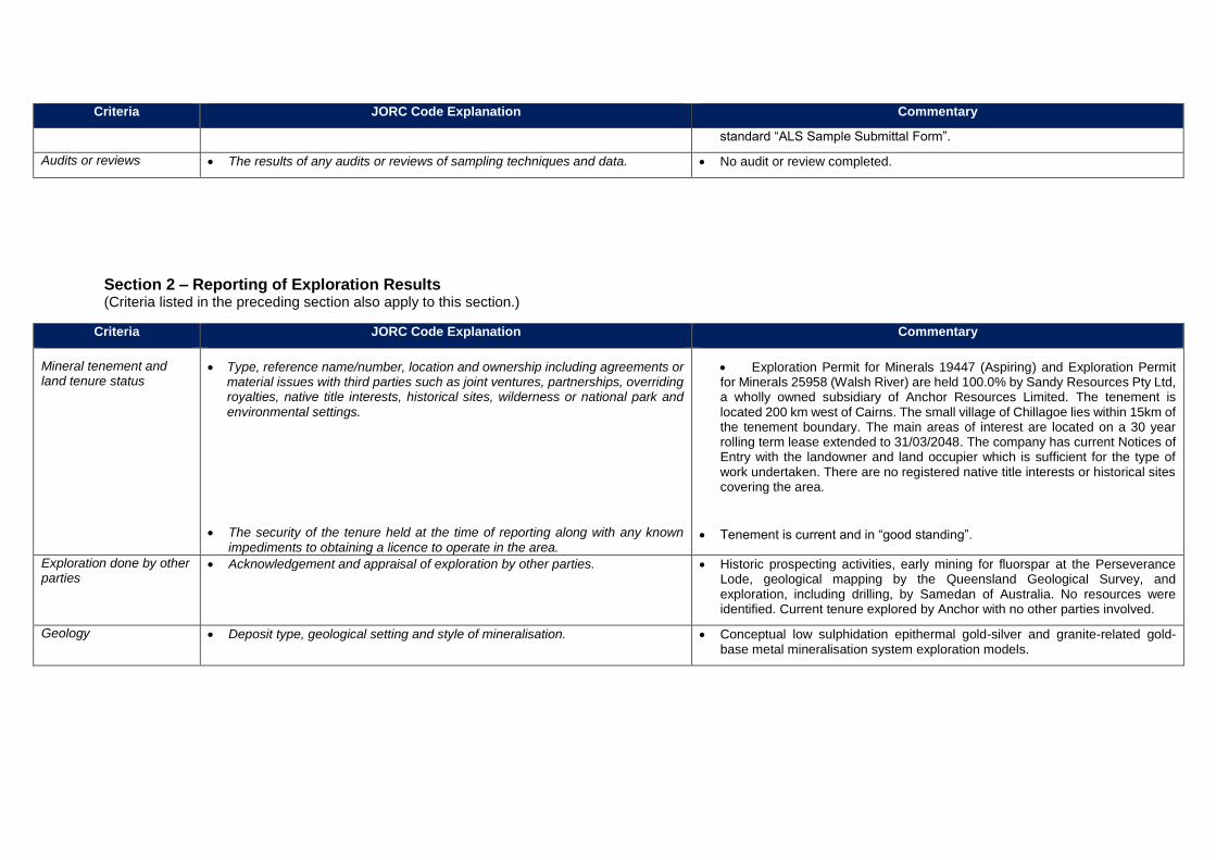
Criteria JORC Code Explanation Commentary
standard “ALS Sample Submittal Form”.
Audits or reviews • The results of any audits or reviews of sampling techniques and data. • No audit or review completed.
Section 2 – Reporting of Exploration Results
(Criteria listed in the preceding section also apply to this section.)
Criteria JORC Code Explanation Commentary
Mineral tenement and land tenure status
• Type, reference name/number, location and ownership including agreements or material issues with third parties such as joint ventures, partnerships, overriding royalties, native title interests, historical sites, wilderness or national park and environmental settings.
• The security of the tenure held at the time of reporting along with any known impediments to obtaining a licence to operate in the area.
• Exploration Permit for Minerals 19447 (Aspiring) and Exploration Permit for Minerals 25958 (Walsh River) are held 100.0% by Sandy Resources Pty Ltd, a wholly owned subsidiary of Anchor Resources Limited. The tenement is located 200 km west of Cairns. The small village of Chillagoe lies within 15km of the tenement boundary. The main areas of interest are located on a 30 year rolling term lease extended to 31/03/2048. The company has current Notices of Entry with the landowner and land occupier which is sufficient for the type of work undertaken. There are no registered native title interests or historical sites covering the area.
• Tenement is current and in “good standing”.
Exploration done by other parties
• Acknowledgement and appraisal of exploration by other parties. • Historic prospecting activities, early mining for fluorspar at the Perseverance Lode, geological mapping by the Queensland Geological Survey, and exploration, including drilling, by Samedan of Australia. No resources were identified. Current tenure explored by Anchor with no other parties involved.
Geology • Deposit type, geological setting and style of mineralisation. • Conceptual low sulphidation epithermal gold-silver and granite-related gold-base metal mineralisation system exploration models.
Criteria JORC Code Explanation Commentary
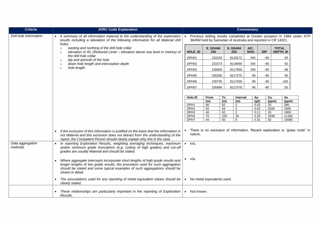
Drill hole Information
• A summary of all information material to the understanding of the exploration results including a tabulation of the following information for all Material drill holes: o easting and northing of the drill hole collar o elevation or RL (Reduced Level – elevation above sea level in metres) of
the drill hole collar o dip and azimuth of the hole o down hole length and interception depth o hole length.
• If the exclusion of this information is justified on the basis that the information is not Material and this exclusion does not detract from the understanding of the report, the Competent Person should clearly explain why this is the case.
• Previous drilling results completed at Doolan prospect in 1984 under ATP 3645M held by Samedan of Australia and reported in CR 14321.
HOLE_ID E_GDA94
Z55 N_GDA94
Z55 AZI_ MAG DIP
TOTAL_ DEPTH_M
DPH01 232193 8118172 345 -60 90
DPH02 231573 8118059 345 -60 92
DPH03 230600 8117958 345 -60 68
DPH05 230256 8117275 90 -90 50
DPH06 230735 8117409 90 -90 100
DPH07 230696 8117578 90 -90 50
Hole ID From To Interval Au Cu As
(m) (m) (m) (g/t) (ppm) (ppm)
DPH1 60 62 2 0.02 20 390
DPH2 52 54 2 0.02 2020 2500
DPH3 40 42 2 0.11 20 1800
DPH6 70 100 30 0.20 2938 11160
DPH7 44 50 6 0.31 82 10580
• There is no exclusion of information. Recent exploration is “grass roots” in nature.
Data aggregation methods
• In reporting Exploration Results, weighting averaging techniques, maximum and/or minimum grade truncations (e.g. cutting of high grades) and cut-off grades are usually Material and should be stated.
• Where aggregate intercepts incorporate short lengths of high grade results and longer lengths of low grade results, the procedure used for such aggregation should be stated and some typical examples of such aggregations should be shown in detail.
• The assumptions used for any reporting of metal equivalent values should be clearly stated.
• n/a.
• n/a.
• No metal equivalents used.
• These relationships are particularly important in the reporting of Exploration Results.
• Not known.

Criteria JORC Code Explanation Commentary
Relationship between mineralisation widths and intercept lengths
• If the geometry of the mineralisation with respect to the drill hole angle is known, its nature should be reported.
• If it is not known and only the down hole lengths are reported, there should be a clear statement to this effect (e.g. ‘down hole length, true width not known’).
• Geometry of mineralised zones currently not known.
• Down hole length, true width not known.
Diagrams
• Appropriate maps and sections (with scales) and tabulations of intercepts should be included for any significant discovery being reported. These should include, but not be limited to a plan view of drill hole collar locations and appropriate sectional views.
• Plan of work area shown in current report.
Balanced reporting
• Where comprehensive reporting of all Exploration Results is not practicable, representative reporting of both low and high grades and/or widths should be practiced to avoid misleading reporting of Exploration Results.
• Reporting of exploration results is balanced and comprehensive.
Other substantive
exploration data
• Other exploration data, if meaningful and material, should be reported including (but not limited to): geological observations; geophysical survey results; geochemical survey results; bulk samples – size and method of treatment; metallurgical test results; bulk density, groundwater, geotechnical and rock characteristics; potential deleterious or contaminating substances.
• Rock chip sampling used to identify areas of interest in stage 1 exploration. Soil sampling has proved to be a successful technique in locating gold and base metals in bedrock. Geological mapping and structural analysis are used in conjunction with soil geochemical results and are important attributes in selecting potential targets.
Further work
• The nature and scale of planned further work (e.g. tests for lateral extensions or depth extensions or large-scale step-out drilling).
• Diagrams clearly highlighting the areas of possible extensions, including the main geological interpretations and future drilling areas, provided this information is not commercially sensitive.
• Follow up work is planned to determine the prospectivity of the preliminary targets identified. Detailed geological mapping together with rock and soil sampling are planned.
• Insufficient work completed to determine possible mineralisation extensions however Doolan may extend into an area of transported overburden cover to the south. Other areas of interest in the Fluorspar area are subject to ongoing work and extensions to the Perseverance Fault are also subject to ongoing work.